Pierson Swamp Drain - Muskegon County, MI
33
Pierson Swamp Drain White River & Montague Townships, Muskegon County, Michigan PRELIMINARY ENGINEERING REPORT Brenda M. Moore Muskegon County Drain Commissioner Project No. 13031.00 December 2013
Transcript of Pierson Swamp Drain - Muskegon County, MI

Pierson Swamp Drain
White River & Montague Townships, Muskegon County, Michigan
PRELIMINARY ENGINEERING REPORT
Brenda M. Moore Muskegon County Drain Commissioner
Project No. 13031.00
December 2013

TABLE OF CONTENTS
PAGE
1.0 INTRODUCTION .................................................................................................. 2 2.0 EXISTING CONDITIONS ..................................................................................... 4 3.0 RECOMMENDATIONS ...................................................................................... 26 4.0 LEGAL DESCRIPTIONS ................................................................................... 27 APPENDICES
APPENDIX A – Exhibit A: Drainage District Boundary Exhibit APPENDIX B – Exhibit B: Proposed Lands to be Added Exhibit

Eng., Inc. 2
1.0 INTRODUCTION The Pierson Swamp Drain is an established County drain located in Sections 13, 14, 23 and 24 of White River Township and Sections 7 and 18 of Montague Township. The drain legally begins at Post Road, and the upper reaches of the main drain extend east to Lamos Road. The established branch drain extends north to Fruitvale Road. By resolution from White River Township, a petition was received by the Muskegon County Drain Commissioner (MCDC) dated April 15, 2013 for the cleaning out, relocating, widening, deepening, straightening, tiling, extending, improving, providing structures, adding lands, adding branches and a relief drain and/or relocating along a highway of the drain known and designated as the Pierson Swamp Drain (portions also referred to as Pierson Creek). The petition describes the establishment of the downstream portions of the waterway, from Post Road to White Lake, as a County drain.
The purpose of this Preliminary Engineering Report is to provide a summary of the existing conditions throughout the proposed Pierson Swamp Drain. The downstream (private) portions of the drain from Post Road to the outlet at White Lake were also inspected and included in the report. The main areas of concern within the drain system are the flashy stream flow conditions, existing culvert capacity and structural issues of the crossings, water quality, and heavy sediment loading into White Lake. The current Pierson Swamp Drain legally commences at Post Road and extends northerly to a point just south of Eilers Road where the drain branches off. The Pierson Swamp main drain runs east and northeasterly to Lamos Road. The drain continues into Montague Township where private branches extend to the north and east. The Pierson Swamp Branch Drain runs northerly (from the point just south of Eilers Road) to Fruitvale Road before heading easterly to Williams Road and its termination point. Several private branch drains feed into the County drain in these areas. The Pierson Swamp drain was legally established in 1904. Based on a review of the file, maintenance and/or construction have been performed on four (4) different occasions since establishment in 1904. In 1911 the main drain was cleaned out. In 1920 a branch drain was added and drain improvements performed. In 1937 drain work and maintenance was performed and in 1971 work was performed on the main drain and branch drain as well. The existing Drainage District boundary contains approximately 3,969 acres and is comprised of lands in White River and Montague Townships. The upper (northern) portions of the watershed, located within the existing District boundary, are composed primarily of agricultural and rural residential lands. The lower portions of the proposed Drainage District, currently private waterway, have a mix of forested, open field and wetland area with rural residential and dense single family residential lands along and near Lake Michigan and White Lake. A large land area in the southern half of the District is occupied with a golf course. The land area of the proposed Drainage District boundary contains approximately 5,968 acres. Approximately 60 percent of the proposed District is comprised of agricultural land. There are no adjacent Drainage Districts to the Pierson Swamp Drain Drainage District based on a review of MCDC records. The Pierson Swamp Drain is primarily open drain throughout with several roadway (culvert) crossings. The lands in the District are drained primarily by direct surface runoff and base flows from agricultural farm tiles into the open drain. The lower (southern) portions of the drain, south of Wilkes Road extended, include rather significant wetland complexes and forested areas.

Eng., Inc. 3
Eng., Inc. was asked to perform the following tasks in order to identify the Drainage District boundary and analyze the existing conditions of the Drain:
• Review the file and history of the drain system at the MCDC’s office. • Review and research existing record information (GIS, aerial photographs, topographic
information, etc.) • Review any documented drain complaint records, maintenance issues and any adjacent
District boundary or Drainage District information maps at the MCDC’s office. Review prior construction work as well.
• Identify the proposed Drainage District boundary and watershed areas for the Pierson
Swamp Drain. • Survey and inspect all road crossings/culverts in the Pierson Swamp Drain study area to
review culvert and stormwater conditions, low areas and potential drainage issues. • Inspect the entire length of both the existing and proposed branch drain system of the
Pierson Swamp Drain. • Inspect the downstream portion (private waterway) of the Pierson Swamp Drain to its
outlet into White Lake. • Provide an independent and unbiased assessment of the stormwater conditions within
the existing Drainage District and the proposed Drainage District boundary. • Compile all analysis in a Preliminary Engineering Report and summarize those findings
at a Board of Determination hearing.

2.0 EXISTING CONDITIONS The lands within the existing Pierson Swamp Drain Drainage District are primarily agricultural and rural residential lands. Increased development of the area to altering land uses (commercial or industrial) will most likely not occur based on current zoning classifications within the District. The lower portions of the proposed Drainage District (south of Post Road) are primarily forested and single family residential areas with a rather large wetland complex near Old Channel Trail. The area also has a golf course encompassing a significant area of land. The area could see some residential development in the future with Lake Michigan, White Lake and the golf course in close proximity. The roadway culverts along the main drain and branch drain were inventoried and visually inspected. The roadway crossings south of Hancock Road are all bridge crossings and appeared to be in fair condition with adequate capacity. The Hancock Road crossing (culvert) failed in January 2013 and has yet to be replaced. The Muskegon County Road Commission is currently reviewing materials and plans to expand the size of the crossing to adequately accommodate runoff from the upstream areas.
Failing timber culvert at W. Eilers Road
Private drain crossings, where landowners have installed culverts across the Drain, were found in a few locations. The location with the most system notable issues was located just north of Post Road where a 30-inch and 36-inch CMP culvert(s) have been placed across the drain centerline. The 30-inch culvert in this location has significant back fall. Both of the culverts were full of sediment and restricting flow through the drain. The restriction can ultimately lead to upstream flooding. There were also several small bridge crossings in the private branches of the upper watershed that can inhibit stream flow if not located above flood elevations. The crossings were in fair condition but the elevation of these structures is a concern.
The stream flow throughout the Drainage District appeared to be very flashy with water levels likely to fluctuate very quickly following rain events. The results of the high stream flow have eroded and deteriorated the banks of the drain in several locations leaving heavy sediment laden water. This type of erosion was observed during a site visit in April 2013 where it was noted that the east bank on the north end of the Post Road culvert had been pulled into the center of the drain following an approximately 2-inch (50% annual chance) rain event (see inset photo). This type of erosion reduces the capacity of the drain and contributes to drain sedimentation as well.Several of the aging culverts within the existing Drainage District boundary are in critical need of repair and/or replacement. A wooden culvert was inspected at Eilers Road that showed characteristics of structural damage as well. The existing CMP culvert at Ramthun Road was beginning to rust out and showed serious signs of deterioration. Evidence of erosion was observed along the banks and headwalls of culverts throughout the length of the Drain, specifically the upstream ends, along with perched culverts and sedimentation.
Eng., Inc. 4

Eng., Inc. 5
Culvert failure at Hancock Road
Lack of vegetative buffer strips between the farmland and the watercourse, including road ditches, was evident during multiple site visits in the northern portion of the Drainage District. Stormwater runoff across agricultural land ideally needs a lengthy vegetative buffer strip to filter out and settle sediment prior to entrance into open drains. The large expanse of open cropland in these areas generates significant amounts of sedimentation during runoff from routine rain events.
Flooding north of Ramthun Road
The high water levels and peak velocities have also put increased stress on roadway culverts and, in particular, the upstream headwalls of the culverts. The existing 11-foot diameter Corrugated Metal Pipe (CMP) culvert at Hancock Road failed on January 30, 2013 during heavy rainfall and snowmelt (approximately 1.10 inches of snowmelt over three days according to NOAA). The failed culvert has still not been replaced during preparation of this report and continues to increase sedimentation into White Lake as bank erosion and roadway sub grade continue to runoff into the stream. Heavy erosion on the upstream banks of the rusted out roadway culvert at Ramthun Road was also very apparent and is very close to damaging the gravel roadway surface if left without proper maintenance. The concrete block headwalls on the east (upstream) side of Lamos Road have also begun to show significant erosion from high water levels.
Flooding was also noted in several locations throughout the District. The most significant flooding was observed along Ramthun Road where large portions of farmland were under water during an April 2013 site inspection. Large areas of standing water were also observed in several locations along Fruitvale Road. The upper portions of the County Drain near Fruitvale Road appear to hold water in the open drain for extended periods of time and the Drain may need to be cleaned out to remain effective at transporting this water. Review of the Pierson Swamp Drain file at the MCDC office revealed that two (2) sedimentation basins have been constructed in recent history on the private branches of the drain in the upper portions of the Drainage District. The sedimentation basins are on private branches of the drain and cannot currently be cleaned out and/or maintained by the Drain Commissioner. Sedimentation basins need to be cleaned out on a regular basis to maintain their effectiveness.
Eng., Inc. 6
The following table lists the condition and survey summary of various areas along the Pierson Swamp main drain, branch drain and private waterway from Post Road to White Lake. Following this table is a series of pictures corresponding to some of the areas listed in the table. PIERSON SWAMP CONDITION SUMMARY: LOCATION DESCRIPTION ELEVATIONS
PIC #
COMMENTS
Ex. Private Waterway
Lifeguard Road Bridge looking downstream
Water ELEV = 577.14 1 Heavy Sediment Discharge
into White Lake Ex. Private Waterway
Lifeguard Road Bridge looking upstream
Water ELEV = 577.14 2 Large open channel with
heavy sediment Ex. Private Waterway
Old Channel Trail Bridge looking downstream
Water ELEV = 577.14 3 Open channel with shallow
banks
Ex. Private Waterway
Old Channel Trail Bridge looking upstream
Water ELEV = 577.14 4 Large wetland complex and
significant water storage area
Ex. Private Waterway
Hancock Road Culvert Failure Pipe Failure
Drain C/L=625.65 5
11-foot diamter CMP culvert failure with erosion
and sedimentation
Ex. Private Waterway
Hancock Road Culvert Failure Pipe Failure
Drain C/L=625.65 6
11-foot diamter CMP culvert failure with erosion
and sedimentation Ex. Private Waterway
Hancock Road Culvert Failure Pipe Failure
Drain C/L=625.65 7
Heavy sedimentation along the banks of channel
Pierson Main Drain
Post Road Culvert 11'x7' INV(N)=634.91 11'x7' INV(S)=633.66
8 11-foot by 7-foot HE RCP culvert with bag rip rap
Pierson Main Drain
Private Culverts north of Post Road
30" INV(N)=632.45 30" INV(S)=633.44 36" INV(N)=632.86 36" INV(S)=632.60
9 30-inch and 36-inch CMP private culverts restricting
flow
Pierson Main Drain
Private Culverts north of Post Road
30" INV(N)=632.45 30" INV(S)=633.44 36" INV(N)=632.86 36" INV(S)=632.60
10 30-inch and 36-inch CMP private culverts restricting
flow
Pierson Main Drain
Sedimentation and Erosion north of Post Road
N/A 11
banks pushed into centerline of drain due to
high stream flow and flashy conditions
Ex. Private Waterway
Sedimentation and Erosion south of Post Road
N/A 12 Sediment and erosion on
banks of drain Pierson
Main Drain Sedimentation between Post
Road and Old 99 Bridge N/A 13
Heavy sedimentation from April 18, 2013 rain event
Pierson Main Drain
Old 99 Bridge C/L ELEV= 635.00 14 Stream flow under the Old
99 Bridge Pierson
Main Drain Old 99 Bridge C/L ELEV=635.00 15
Stream flow and erosion near Old 99 Bridge
Pierson Branch Drain
West Eilers Road Culvert Ditch C/L(N)=639.77 Ditch C/L(S)=641.13
16 11-foot by 5-foot CMP
culvert in Good Condition (recent construction)
Pierson Branch Drain
West Eilers Road Culvert N/A 17 Stream flow south of West
Eilers Road
Pierson Main Drain
East Eilers Road Culvert Ditch C/L(N)=646.94 Ditch C/L(S)=647.96
18 Wood Culvert at East Eilers
Road in Poor Condition

Eng., Inc. 7
Pierson Main Drain
East Eilers Road Culvert Ditch C/L(N)=646.94 Ditch C/L(S)=647.96
19 Wood Culvert at East Eilers
Road in Poor Condition
Pierson Main Drain Lamos Road Culvert
N INV(E)=655.56 N INV(W)=656.09 S INV(E)=655.73 S INV(W)=655.99
20 Two (2) 6.5-foot by 9-foot CMP Culverts with concrete
block slope protection
Pierson Main Drain Lamos Road Culvert
N INV(E)=655.56 N INV(W)=656.09 S INV(E)=655.73 S INV(W)=655.99
21 Erosion on slope of culverts from high stream flow and
flashy conditions
Pierson Branch Drain
Ramthun Road Culvert
6'x8' INV(N)=644.83 Ditch C/L (N)=643.73 6'x8' INV(S)=644.04 Ditch C/L (S)=644.96
22 6-foot by 8-foot CMP
culvert with significant erosion and rusting
Pierson Branch Drain
Ramthun Road Culvert
6'x8' INV(N)=644.83 Ditch C/L (N)=643.73 6'x8' INV(S)=644.04 Ditch C/L (S)=644.96
23 South side of Ramthun
Road culvert
Pierson Branch Drain
Fruitvale Road Culvert
E 36" INV(N)=648.92 E 36" INV(S)=648.83 W 36" INV(N)=648.87 W 36" INV(S)=649.02
24 two (2) 36-inch RCP
culverts with standing water
Pierson Branch Drain
Fruitvale Road Culvert
E 36" INV(N)=648.92 E 36" INV(S)=648.83 W 36" INV(N)=648.87 W 36" INV(S)=649.02
25 North side of Fruitvale Road
showing standing water and sedimentation
Pierson Branch Drain
Fruitvale Road Driveway Culvert
48" INV(E)=651.90 48" INV(W)=651.51
26 48-inch CMP culvert in fair
condition
Pierson Branch Drain
Fruitvale Road Driveway Culvert
36"x60" C/L(E)=653.04 36"x60"
C/L(W)=652.10 27
36-inch rise by 60-inch span concrete culvert in fair
condition Pierson Branch Drain
Fruitvale Road Driveway Culvert
48" INV(E)=652.46 48" INV(W)=652.68
28 48-inch CMP culvert with
sedimenation in pipe
Private Branch Drain
Williams Road Culvert 18" INV(N)=655.35 29 18-inch RCP culvert from
north
Private Branch Drain
William Road & Fruitvale Road Culvert
24"x36" INV(E)=653.73 24"x36"
INV(W)=654.64 30
24-inch by 36-inch HE RCP culvert in good condition
Private Branch Drain
William Road & Fruitvale Road Culvert
N/A 31 Sedimentation in culvert
Pierson Main Drain
Farmland(s) north of Ramthun Road
N/A 32 Significant flooding
Pierson Main Drain
Stream Flow near Eilers Road
N/A 33 Heavy sedimentation and runoff following rain event
Pierson Main Drain
Stream Flow near Eilers Road
N/A 34 Heavy sedimentation and runoff following rain event
Pierson Branch Drain
Stream Flow south of Fruitvale Road
N/A 35 Standing water in
drainageway
Pierson Branch Drain
South side of Fruitvale Road west of Williams Road
N/A 36 Standing water in
farmlands

Eng., Inc. 8
PICTURE #1
Picture #1 shows the Lifeguard Road Bridge structure looking downstream towards White Lake (South).
PICTURE #2
Picture #2 looking upstream (north) from Lifeguard Road Bridge (note the heavy sedimentation).

Eng., Inc. 9
PICTURE #3
Picture #3 is looking downstream from the bridge structure on Old Channel Trail.
PICTURE #4
Picture #4 shows the large wetland complex just northeast of the Old Channel Trail bridge.
Eng., Inc. 10
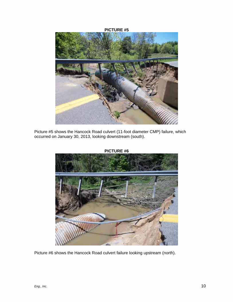
PICTURE #5
Picture #5 shows the Hancock Road culvert (11-foot diameter CMP) failure, which occurred on January 30, 2013, looking downstream (south).
PICTURE #6
Picture #6 shows the Hancock Road culvert failure looking upstream (north).

Eng., Inc. 11
PICTURE #7
Picture #7 shows heavy sedimentation on the banks south of the Hancock Road culvert failure.
PICTURE #8
Picture #8 shows an 11-foot by 7-foot horizontal elliptical pipe under Post Road. The culvert is guarded with bag riprap in fair condition.

Eng., Inc. 12
PICTURE #9
Picture #9 shows 30-inch and 36-inch CMP private culverts with considerable back fall, which restricts flow, installed across the drain approximately 150-feet north of Post Road.
PICTURE #10
Picture #10 is another photo of the two private culverts located approximately 150-feet north of Post Road which show considerable blockage causing significant reduction in capacity. The culverts have become an obstacle for stormwater flow.

Eng., Inc. 13
PICTURE #11
Picture #11 shows sediment being pulled toward the drain centerline just north of the Post Road culvert due to flashy water levels. The sediment will eventually make its way downstream to White Lake.
PICTURE #12
Picture #12 shows bank sedimentation and erosion south of Post Road.

Eng., Inc. 14
PICTURE #13
Picture #13 shows significant sedimentation during an April 18, 2013 rain event where stormwater came out of bank.
PICTURE #14
Picture #14 shows flow under the Old 99 Bridge looking west.

Eng., Inc. 15
PICTURE #15
Picture #15 shows the west side of the Old 99 Bridge where minor erosion has taken place along the banks.
PICTURE #16
Picture #16 shows the recent construction of an 11-foot by 5-foot CMP culvert structure at West Eilers Road looking south.

Eng., Inc. 16
PICTURE #17
Picture #17 shows stream flow from West Eilers Road looking north.
PICTURE #18
Picture #18 shows an aged wooden culvert at East Eilers Road looking south.

Eng., Inc. 17
PICTURE #19
Picture #19 is a closer look at the north side of the aged wooden culvert. The structure will need replacement in the near future as it shows signs of structural deformation.
PICTURE #20
Picture #20 shows two (2) 6.5-foot by 9-foot CMP culverts with concrete block slope protection on the west side (downstream side) of Lamos Road looking east.

Eng., Inc. 18
PICTURE #21
Picture #21shows the two (2) CMP culverts on the east side of Lamos Road (upstream side). The concrete block slope protection has started to fail due to high water levels and flashy stream conditions.
PICTURE #22
Picture #22 shows a 6-foot by 8-foot rusting CMP culvert on the north side (upstream side) of Ramthun Road. The culvert is starting to deteriorate and is experiencing significant erosion due to high water levels and flashy stream conditions.

Eng., Inc. 19
PICTURE #23
Picture #23 shows the culvert and stream flow on the south side (downstream side) of Ramthun Road looking north. The significant change in water elevation relative to the top of the culvert indicates possible structural issues.
PICTURE #24
Picture #24 shows two (2) 36-inch diameter RCP culverts at Fruitvale Road looking north with significant standing water.

Eng., Inc. 20
PICTURE #25
Picture #25 shows the culverts on the north side of Fruitvale Road. Standing water exists in this location for extended periods following rain events due to sedimentation in the Drain.
PICTURE #26
Picture #26 shows a perched 48-inch CMP driveway crossing along Fruitvale Road, looking east, in fair condition. However, the bottom 1/3 of the culvert has began to show signs of rust.

Eng., Inc. 21
PICTURE #27
Picture #27 shows a 36-inch rise by 60-inch span concrete culvert along Fruitvale Road, looking east, with natural bottom. The structure is in poor condition and appears to be constructed without a footing.
PICTURE #28
Picture #28 shows a 48-inch CMP driveway culvert along Fruitvale Road, looking east. The culvert has 18 inches of sediment in the bottom of the pipe and needs to be cleaned out.

Eng., Inc. 22
PICTURE #29
Picture #29 shows an 18-inch culvert at Williams Road and Fruitvale Road, looking east.
PICTURE #30
Picture #30 shows a 24-inch by 36-inch HE and 18-inch RCP culvert crossing at Williams Road, looking north.

Eng., Inc. 23
PICTURE #31
Picture #31 shows the 24-inch by 36-inch HE pipe at Williams Road, looking south. The pipe is 50 percent filled with sediment.
PICTURE #32
Picture #32 shows considerable flooding in the farmlands north of Ramthun Road between Old 99 Road and Lamos Road.

Eng., Inc. 24
PICTURE #33
Picture #33 shows the drain west of Eilers Road, looking west, following a significant rain event on April 18, 2013. Significant sedimentation exists in the drain and along the banks because of adjacent agricultural runoff with no buffer strips along the Drain and no upstream detention to limit flashy stormwater conditions.
PICTURE #34
Picture #34 shows runoff on the west side of Eilers Road and heavy sedimentation from the upper watershed due to agricultural runoff which lacks buffer strips.

Eng., Inc. 25
PICTURE #35
Picture #35 shows the Drain, looking south from Fruitvale Road. Water will stand in the drain for extended periods of time indicating existing grade issues and sedimentation.
PICTURE #36
Picture #36 shows standing water along the south side of Fruitvale Road to the west of Williams Road, looking west.

Eng., Inc. 26
3.0 RECOMMENDATIONS The following recommendations refer to drainage issues in areas within the proposed Pierson Swamp Drain Drainage District: RECOMMENDATIONS TO THE PIERSON SWAMP DRAIN:
• Establish a Drainage District boundary that includes tributaries of the existing private waterway from Post Road to the outlet at White Lake. The larger Drainage District will allow for more comprehensive care of the Pierson Creek watershed.
• Establish the private drain branches which are servicing more than one property in the northern portions of the Drainage District as legal County drains. These branches currently discharge to the County drain and are significant factors to sedimentation in the drain. The establishment of these branches as County drains will allow for early corrective measures to take place in the headwaters.
• Extend the legal limits of the County drain from Post Road to the outlet at White Lake. The extension of the drain will allow for a comprehensive analysis of all issues in the watershed discharging to White Lake from Pierson Creek.
• A complete culvert analysis and review at each roadway and private crossing should be performed to identify capacity or structural issues in more detail. This analysis should include modeling of the watershed to determine culvert capacity issues and adequacy of sizing and an analysis of culvert repair versus replacement.
• A complete evaluation of methodologies to decrease peak velocities and sedimentation in the system. The evaluation would also identify locations where bank stabilization and velocity reduction measures should be constructed.
• Identify potential areas for stormwater detention/retention and sedimentation basins to reduce flashy stream conditions and heavy sediment loading into White Lake.
• Work with agricultural property owners to identify locations where the vegetative buffer strip can be added, lengthened and/or expanded between their lands and open drainage ways (roadway ditches, private drains and County drains) to reduce sedimentation.
• The two (2) existing sedimentation basins (currently on private drain branches) should be cleaned out and maintained on a regular basis for effectiveness as a water quality measure.
• Review potential grant funding opportunities to improve water quality within the watershed and reduce sediment loading into White Lake. We understand that White Lake is an Area of Concern (AOC).
• Work with the Michigan DEQ and other stakeholders in reviewing the watershed to improve connectivity within the system (reduce the number of perched culverts) and integration of wetland areas as potential places for stormwater quantity mitigation and water quality improvement areas.
• Extend branches to relieve localized flooding in the District.

Eng., Inc. 27
3.0 LEGAL DESCRIPTIONS
Pierson Swamp Drain Drainage District Boundary Description PART OF SECTION 2, TOWNSHIP 11 NORTH, RANGE 18 WEST, WHITE RIVER TOWNSHIP, AND ALL OF SECTIONS 13 AND 26, TOWNSHIP 12 NORTH, RANGE 18 WEST, WHITE RIVER TOWNSHIP, AND PART OF SECTIONS 11,12,14,15,22,23,24, 25, 27, 35, AND 36, TOWNSHIP 12 NORTH, RANGE 18 WEST, WHITE RIVER TOWNSHIP, AND PART OF SECTIONS 7,8,17, 18, AND 19, TOWNSHIP 12 NORTH, RANGE 17 WEST, MONTAGUE TOWNSHIP, MUSKEGON COUNTY, MICHIGAN MORE PARTICULARLY DESCRIBED AS: BEGINNING AT A POINT ON THE WEST LINE OF SECTION 36 TOWNSHIP 12 NORTH, RANGE 18 WEST, WHITE RIVER TOWNSHIP, SAID POINT LYING 426 FEET SOUTH FROM THE NORTHWEST CORNER OF SAID SECTION 36, THENCE N54°51’E 1912 FEET, THENCE N44°51’E 1678 FEET, THENCE N 1°34’E 930 FEET, THENCE N51°10’W 1090 FEET, THENCE N 29°45’E 1136 FEET, THENCE N30°23’W 808 FEET, THENCE N46°20’E 1054 FEET, THENCE N77°51’E 565 FEET, THENCE N38°59’E 1845 FEET, THENCE N76°47’E 717 FEET, THENCE N85°37’E 182 FEET, THENCE S87°12’E 2284 FEET, THENCE N44°19’E 760 FEET, THENCE N2°27’E 1400 FEET, THENCE N20°27’E 596 FEET, THENCE N45°43’E 1444 FEET, THENCE N35°47’E 1274 FEET, THENCE N52°50’E 925.7 FEET MORE OR LESS TO THE EAST 1/4 CORNER OF SECTION 18, TOWNSHIP 12 NORTH, RANGE 17 WEST, THENCE NORTHERLY ALONG SAID EAST LINE OF SAID SECTION 18 A DISTANCE OF 264 FEET, THENCE N89°52’E 449 FEET, THENCE S57°07’E 1013 FEET, THENCE N85°55’E 1757 FEET, THENCE N81°54’E 913 FEET, THENCE N2°35’E 685 FEET, THENCE N50°31’W 1620 FEET, THENCE N5°10’E 669 FEET, THENCE N15°10’E 700 FEET, THENCE N42°W 395 FEET, THENCE N0°35’E 516 FEET, THENCE N87°35’W 376 FEET, THENCE N17°34’W 818 FEET, THENCE N68°02’W 759 FEET, THENCE N0°48’W 1008 FEET, THENCE N44°38’W 951 FEET, THENCE N39°34’W 1054 FEET MORE OR LESS TO A POINT ON THE EAST LINE OF SECTION 7, TOWNSHIP 12 NORTH, RANGE 17 WEST SAID POINT LYING 553 FEET SOUTHERLY FROM THE NORTHEAST CORNER OF SAID SECTION 7, THENCE N38°01’W 600 FEET, THENCE N88°30’W 135 FEET, THENCE S58°19’W 547 FEET, THENCE N87°55’W 358 FEET, THENCE S44°17’W 511 FEET, THENCE N69°29’W 437 FEET, THENCE N88°46’W 520 FEET, THENCE N78°34’W 636 FEET, THENCE S82°06’W 1211 FEET, THENCE S49°20’W 788 FEET, THENCE S16°43’W 360 FEET, THENCE N87°36’W 353 FEET, THENCE S0°45’W 313 FEET, THENCE S51°39’W 422 FEET, THENCE N87°22’W 293 FEET, THENCE S23°40’W 511 FEET, THENCE N88°42’W 445 FEET, THENCE N35°27’W 435 FEET, THENCE N79°22’W 450 FEET, THENCE S89°15’W 683 FEET, THENCE S1°04’W 282 FEET TO THE CENTER OF SECTION OF SECTION 12, TOWNSHIP 12 NORTH, RANGE 18 WEST, THENCE N86°59’W 589 FEET, THENCE S81°40’W 744 FEET, THENCE S0°56’W 1665 FEET. THENCE N67°41’W 631 FEET, THENCE N88°16’W 733.2 FEET MORE OR LESS TO A POINT ON THE WEST LINE OF SAID SECTION 12 SAID POINT LYING 1019 FEET NORTH FROM THE SOUTHWEST CORNER OF SAID SECTION

Eng., Inc. 28
12 , THENCE N73°34’W 1367 FEET, THENCE S1°11’W 1385 FEET, THENCE N89°09’W 1319.5 FEET MORE OR LESS TO THE SOUTH 1/4 CORNER OF SECTION 11, TOWNSHIP 12 NORTH, RANGE 18 WEST, THENCE N89°04’W 555 FEET, THENCE S3°03’W 1310 FEET, THENCE S38°42’W 847 FEET, THENCE S43°48’W 312 FEET, THENCE S1°19’W 768 FEET, THENCE N75°17’W 668 FEET, THENCE S89°25’W 635 FEET, THENCE S72°49’W 187 FEET, THENCE S 60°21’W 210 FEET, THENCE S3°27’E 626 FEET, THENCE S 37°11’W 428 FEET, THENCE S30°56’W 1594 FEET, THENCE S0°44’W 881 FEET, THENCE S80°53’W 498 FEET, THENCE S 2°50’W 630 FEET, THENCE S35°31’W 637 FEET, THENCE S 1°24’W 166 FEET, THENCE S84°20’W 121 FEET, THENCE S 0°03’W 1012 FEET, THENCE S4°42’W 433 FEET, THENCE S 53°56’W 233 FEET, THENCE S 0°12’W 651 FEET, THENCE S 12°25’E 397 FEET, THENCE S 45°31’W 271 FEET, THENCE S 55°47’W 732 FEET, THENCE S2°43’E 681 FEET, THENCE S7°24’E 1059 FEET, THENCE S16°08’E 1639 FEET, THENCE S28°44’E 449 FEET, THENCE S17°12’W 282 FEET, THENCE S11°52’E 1941 FEET, THENCE S19°50’E 1573 FEET, THENCE S 56°32’E 475 FEET, THENCE S20°36’E 375 FEET, THENCE S25°42’E 360 FEET, THENCE S23°02’E 1328 FEET, THENCE S29°12’E 372 FEET, THENCE S43°11’E 236 FEET, THENCE S 19°24’W 332 FEET, THENCE S10°30’E 456 FEET, THENCE S34°13’E 335 FEET, THENCE S18°10’E 71 FEET, THENCE S 8°17’W 250 FEET, THENCE S14°E 1687 FEET, THENCE S 40°11’E 226 FEET, THENCE S3°15’E 442 FEET, THENCE S 14°59’E 635 FEET, THENCE N79°51’E 602 FEET, THENCE S60°39’E 253 FEET, THENCE S52°10’E 186 FEET, THENCE N89°57’E 88 FEET, THENCE N15°51’E 526 FEET, THENCE N35°51’W 362 FEET, THENCE N1°45’E 641 FEET, THENCE N25°23’E 1273 FEET, THENCE N19°28’E 1161 FEET, THENCE N0°43’E 422 FEET, THENCE N 10°36’E 1340 FEET, THENCE N3°04’W 1320 FEET, THENCE N6°05’E 1088 FEET, THENCE N32°55’E 1292 FEET, MORE OR LESS TO THE POINT OF BEGINNING.
Pierson Swamp Drain, Main Drain and Branches First Order of Determination - Route and Course Descriptions
MAIN DRAIN THE ROUTE AND COURSE OF THE MAIN DRAIN ACROSS SECTION 2, TOWNSHIP 11 NORTH, RANGE 18 WEST, WHITE RIVER TOWNSHIP, AND ACROSS SECTIONS 35,26,23,24,13, TOWNSHIP 12 NORTH, RANGE 18 WEST WHITE RIVER TOWNSHIP, AND ACROSS SECTIONS 18 AND 7, TOWNSHIP 12 NORTH, RANGE 17 WEST, MONTEGUE TOWNSHIP, MUSKEGON COUNTY, MICHIGAN, MORE PARTICULARLY DESCRIBED AS BEGINNING AT A POINT A WHITE LAKE SAID POINT LYING 3950 FEET SOUTH AND 1630 FEET WEST FROM THE NORTHEAST CORNER OF SAID SECTION 2, THENCE ACROSS SAID SECTION 2 THE FOLLOWING SIX(6) COURSES; N25°E 150 FEET, N55°W 650 FEET, THENCE N15°W 765 FEET, THENCE N31°W 900 FEET, THENCE N10°W 1000 FEET, THENCE N39°E 1350 FEET, THENCE ACROSS SAID SECTION 35 THE FOLLOWING FIVE(5) COURSES; N27°E 760 FEET, N16°W 2100 FEET, N53°W 600 FEET, N24°W 1750 FEET, N5°E 550 FEET, THENCE ACROSS SAID SECTION 26 THE FOLLOWING

Eng., Inc. 29
SEVEN COURSES; N53°E 870 FEET, N33°E 1100 FEET, N15°E 525 FEET, N28°W 545 FEET, N60°E 900 FEET, N13°E 2030 FEET, N42°E 480 FEET, THENCE ACROSS SAID SECTION 23 THE FOLLOWING NINE(9) COURSES; N42°E 200 FEET, N40°W 825 FEET, N22°E 2000 FEET, N4°E 635 FEET, N49°E 300 FEET, N22°E 540 FEET, NORTH 470 FEET, N38°E 470 FEET, S75°E 743 FEET, THENCE ACROSS SAID SECTION 24 THE FOLLOWING FOUR(4) COURSES; S75°E 947 FEET, EAST 400 FEET, N68°E 600 FEET, N54°E 913 FEET, THENCE ACROSS SAID SECTION 13 THE FOLLOWING THREE(3) COURSES; N54°E 1260 FEET, N68°E 1000 FEET, N56°E 985 FEET, THENCE ACROSS SAID SECTION 18 THE FOLLOWING ELEVEN (11) COURSES; N56°E 800 FEET, S76°E 850 FEET, S2°E 565 FEET, N73°E 785 FEET, N54°E 700 FEET, N7°E 540 FEET, N73°W 300 FEET, N33°W 650 FEET, N81°W 650 FEET, N6°W 1200 FEET, N29°W 710 FEET, THENCE ACROSS SAID SECTION 7 THE FOLLOWING FIVE(5) COURSES; N29°W 450 FEET, N8°E 1020 FEET, N64°E 2500 FEET, N38°E 900 FEET, N63°E 1810 FEET TO THE POINT OF ENDING. BRANCH ONE BEGINNING AT A POINT ON THE MAIN DRAIN SAID POINT LYING 1744 FEET WEST AND 1705 FEET SOUTH FROM THE NORTHEAST CORNER OF SAID SECTION 26, THENCE N47°E 2400 FEET TO THE POINT OF ENDING. BRANCH TWO BEGINNING AT A POINT ON THE MAIN DRAIN SAID POINT LYING 1743 FEET WEST FROM THE NORTHEAST CORNER OF SAID SECTION 26 THENCE WEST 2200 FEET, THENCE NORTH 1320 FEET, THENCE S89°E 1340 FEET TO THE POINT OF ENDING. BRANCH THREE BEGINNING AT A POINT ON BRANCH TWO SAID POINT LYING 1331 FEET EAST AND 752 FEET NORTH FROM THE NORTHWEST CORNER OF SAID SECTION 26, THENCE S68°W 570 FEET, THENCE N51°W 300 FEET, THENCE N83°W 500 FEET TO THE POINT OF ENDING. BRANCH FOUR BEGINNING AT A POINT ON THE MAIN DRAIN SAID POINT LYING 729 FEET WEST AND 435 FEET SOUTH FROM THE NORTHEAST CORNER OF SAID SECTION 23, THENCE N 6°E 2885 FEET, THENCE N29°E 1035 FEET, THENCE NORTH 600 FEET, THENCE S87°E 700 FEET, THENCE N1°E 1345 FEET, THENCE S87°E 1410 FEET, THENCE NORTH 550 FEET, THENCE EAST 580 FEET TO THE POINT OF ENDING.

Eng., Inc. 30
BRANCH FIVE BEGINNING AT A POINT ON THE MAIN DRAIN SAID POINT LYING 2640 FEET WEST AND 315 FEET NORTH FROM THE EAST 1/4 CORNER OF SAID SECTION 18, THENCE N61°E 800 FEET, THENCE N5°E 800 FEET, THENCE N59°E 550 FEET, THENCE N15°E 950 FEET, THENCE N5°W 700 FEET, THENCE N42°E 540 FEET, THENCE N78°E 900 FEET TO THE POINT OF ENDING. BRANCH SIX BEGINNING AT A POINT ON BRANCH FIVE SAID POINT LYING 1922 FEET WEST AND 902 FEET NORTH FROM THE EAST 1/4 CORNER OF SAID SECTION 18, THENCE N87°E 560 FEET, THENCE N39°E 410 FEET, THENCE EAST 1730 FEET, THENCE N48°E 370 FEET, THENCE N83°E 1770 FEET TO THE POINT OF ENDING. BRANCH SEVEN BEGINNING AT A POINT ON BRANCH SIX SAID POINT LYING 1337 FEET EAST AND 1550 FEET NORTH FROM THE EAST 1/4 CORNER OF SAID SECTION 18, THENCE N34°E 1150 FEET TO THE POINT OF ENDING. BRANCH EIGHT BEGINNING AT A POINT ON BRANCH SIX SAID POINT LYING 625 FEET EAST AND 1250 FEET NORTH FROM THE EAST 1/4 CORNER OF SAID SECTION 18, THENCE S47°E 560 FEET, THENCE S73°E 650 FEET, THENCE S89°E 975 FEET TO THE POINT OF ENDING. BRANCH NINE BEGINNING AT A POINT ON BRANCH FIVE SAID POINT LYING 1400 FEET WEST AND 1780 FEET NORTH FROM THE EAST 1/4 CORNER OF SAID SECTION 18, THENCE N67°E 1560 FEET TO THE POINT OF ENDING. BRANCH TEN BEGINNING AT A POINT ON THE MAIN DRAIN SAID POINT LYING 2290 FEET WEST AND 45 FEET SOUTH FROM THE EAST 1/4 CORNER OF SAID SECTION 7, THENCE S70°E 2400 FEET TO THE POINT OF ENDING. BRANCH ELEVEN BEGINNING AT A POINT ON BRANCH TEN SAID POINT LYING 850 FEET WEST AND 480 FEET SOUTH FROM THE EAST 1/4 CORNER OF SAID SECTION 7, THENCE N47°E 1100 FEET TO THE POINT OF ENDING.