Phytolith-based palaeoenvironmental reconstructions - PalaeoWorks

Phytolith Analysis as a Palaeoecological
Tool for Reconstructing Mid-to Late-
Pleistocene Environments in the
Olorgesailie Basin, Kenya
OLORGESAILIE BASIN Photo by the author
Environmental & Geographical Sciences Department
By: Rahab N. Kinyanjui (KNYRAH001)
University of Cape Town
October 2011

ii
Dissertation Presented for the degree of Masters of Science (MSc.)
In the department of Environmental & Geographical Sciences Department
At the University of Cape Town
Cape Town, South Africa
By
Rahab N. Kinyanjui
University of Cape Town
October 2011
Revised February 2012
Supervisor: Michael Meadows (Prof.)
Head, Environmental & Geographical Science
Department
University of Cape Town, South Africa
Co-supervisor: Lindsey Gillson (Dr.)
Plant & Conservation Unit
Botany Department

iii
University of Cape Town, South Africa
Declaration
I know the meaning of plagiarism and declare that all of the work in the dissertation, save for that
which is properly acknowledged, is my own.
1. I know that plagiarism is wrong. Plagiarism is to use another’s work and pretend that
it is one’s own.
2. I have used the author-date convention for citation and referencing. Each contribution
to, and quotation in, this project thesis from the works of other people has been
attributed, and has been cited and referenced.
3. This thesis is my own work
4. I have not allowed, and will not allow, anyone to copy my work with intention of
passing it off as his/her own work.
5. I acknowledge that copying someone else’s assignment essay, or parts of it, is wrong,
and declare that this is my own work.
Signature

iv
Acknowledgements
This work would not have been a success if it were not for the great contribution and support of the
following great people. Thanks to all.
Thanks to my family and friends who have always been there for me, in times of high and low tides.
Special thanks to my dear husband Simon Wahome for his unconditional love: you stood by me and
ensured that my loving daughters, Angela and Clare, put up with my constant absence while away
from home. Thanks to you!
Special thanks to my two supervisors who tirelessly advised and guided me through my Msc. studies.
To Prof. Michael Meadows, for his dedicated supervision, patience and continued support and
positive criticisms that led to the realization of this thesis. To Associate Prof. Lindsey Gillson, who
not only acted as my mentor and friend during the entire period, but also had trust in me and
facilitated the financial support that covered all the expenses incurred during my academic endeavour,
travels and living expenses during my stay at the University of Cape Town. Thank you!
Thanks to the Olorgesailie project team for their generous support during my field work. My special
thanks go to Prof. Rick Potts, Director of Human Origins Program, National Museums of Natural
History, Smithsonian Institution, for his generous support both morally and financially through my
field work, travel and living expenses during my stay in Calgary and Washington DC. Thanks also to
Dr. Kay Behrensmeyer for her guidance in identifying and tracing the palaeosols from geological
trenches which she had described, and for her endurance in the heat of the day. Thank you!
Special thanks to Dr, Geoffrey Mwachala for the reference plant collection from Taita hills under
Earth watch Expedition Program and for botanical aspect of the entire plant specimens in this study.
Thank you!
Thanks to department of Archaeology, University of Calgary for accepting me as one of them and
offering me laboratory space and equipment used for processing the reference collection and also the
initial sediment test-samples. Special thanks to Dr. Julio Mercader for sharing with me his expertise
on methods used to process phytolith studied and his graduate students who made life tolerable in a
foreign country. Thank you!
Thanks to National Museums of Kenya, Earth sciences department, Palynology and Paleobotany
section for their enormous support that made it possible for completion of my analyses and writing.
My special thanks are extended to the Director General, Dr. Idle Farah; who had trust in me and never
hesitated to offer support whenever I needed it and spearheaded the institution support. Thanks to Mr.

v
Stephen Mathai for his continued encouragement. Special thanks are extended to Ms. Veronica
Muiruri who has been a wonderful colleague and friend both in the lab and fulfilling in my role as
mother to daughters while away from home and particularly for attending to my very personal
difficult situation. Thank you!
There are many people I would like to thank for their great contribution; specifically I would like to
thank Dr. Gatere George for statistical consultation, Dr. Mugambi George for editing the plates and
figures and Mr. Simon Kang'ethe for the maps. Very special thanks go to Prof. Timm Hoffman for the
precious time he took to proof-read this thesis. Thank you!
Last but not least, my appreciation goes to the three anonymous examiners for their honest and
positive criticism that further improved the quality of this thesis. Their comments and suggestions
have greatly contributed to the relevance of this research in the broader palaeocological discipline.
Thank you!

vi
Table of contents
DECLARATION................................................................................................................................ III
ACKNOWLEDGEMENTS ...............................................................................................................IV
TABLE OF CONTENTS ...................................................................................................................VI
LIST OF FIGURES ............................................................................................................................XI
LIST OF PLATES ............................................................................................................................ XII
LIST OF TABLES .......................................................................................................................... XIII
ABSTRACT ...................................................................................................................................... XIV
CHAPTER ONE: INTRODUCTION ............................................................................................... 14
1.1 INTRODUCTION ................................................................................................................... 14
1.2 RESEARCH OBJECTIVES .................................................................................................. 15
1.2.1 AIM AND OBJECTIVES .................................................................................................................................... 16
1.3 THESIS STRUCTURE .......................................................................................................... 17
CHAPTER TWO: OLORGESAILIE BASIN .................................................................................. 18
2.1 INTRODUCTION ................................................................................................................... 18
2.1.1 LOCATION AND GEOLOGY OF THE STUDY SITE ..................................................................................................... 18 2.1.2 CURRENT VEGETATION ................................................................................................................................... 18 2.1.3 CONTEMPORARY CLIMATE .............................................................................................................................. 20 2.1.4 GEO-ARCHAEOLOGY ...................................................................................................................................... 21
2.2 SUMMARY ............................................................................................................................. 23
CHAPTER THREE: LITERATURE REVIEW .............................................................................. 24
3.1 INTRODUCTION ......................................................................................................................... 24
3.2 PHYTOLITH ANALYSIS AS A PALAEOECOLOGICAL TOOL ........................................ 24
3.3 ENVIRONMENTAL RECORDS IN MAJOR HOMININ SITES IN EAST AFRICA ......... 25
3.3.1 PLIO-PLEISTOCENE ENVIRONMENTS.................................................................................................................. 26 3.3.2 PALAEOENVIRONMENTS WITHIN THE OLORGESAILIE BASIN ................................................................................... 29
3.4 CLIMATIC RECORDS IN THE RIFT VALLEY REGION DURING THE PLEISTOCENE
PERIOD ............................................................................................................................................... 30
CHAPTER FOUR: MATERIALS AND METHODS ..................................................................... 33
vii
4.1 INTRODUCTION ......................................................................................................................... 33
4.2 MATERIALS ................................................................................................................................ 34
4.2.1 REFERENCE COLLECTION ................................................................................................................................. 34 4.2.1.1 Sampling procedures ........................................................................................................................ 35
4.2.1.2 Extracting Phytoliths from modern plants ....................................................................................... 37
4.2.2 SOILS AND SEDIMENTS ................................................................................................................................... 38 4.2.2.1 Chronology and sampling procedures .............................................................................................. 38
4.2.2.2 Target palaeosol .............................................................................................................................. 40
4.2.2.3 Extracting phytoliths from sediments .............................................................................................. 42
4.2.3 MICROSCOPIC ANALYSIS ................................................................................................................................. 43
4.3 MORPHOLOGICAL CLASSIFICATION ................................................................................ 44
4.3.1 GRASS SHORT-CELL PHYTOLITHS....................................................................................................................... 44 4.3.1.1 Bilobates- ......................................................................................................................................... 45
4.3.1.2 Saddles- ............................................................................................................................................ 46
4.3.1.3 Towers- ............................................................................................................................................ 46
4.3.1.4 Crosses/ quadralobate ..................................................................................................................... 46
4.3.1.5 Trapeziform polylobate .................................................................................................................... 46
4.3.1.6 Rondels/Trapeziforms ...................................................................................................................... 47
4.3.1.7 Bulliforms ......................................................................................................................................... 47
4.3.2 EPIDERMAL APPENDAGES (OTHER SILICA CELL PHYTOLITHS) ................................................................................... 47 4.3.2.1 Hairs- ................................................................................................................................................ 47
4.3.2.2 Hair base- ......................................................................................................................................... 47
4.3.2.3 Trichomes/ scutiform- ...................................................................................................................... 47
4.3.2.4 Papillae/Achene- .............................................................................................................................. 48
4.3.2.5 Stomata- .......................................................................................................................................... 48
4.3.2.6 Tracheids and Schlereids- ................................................................................................................. 48
4.3.3 SILICA SKELETONS ......................................................................................................................................... 48 4.3.3.1 Silica skeletons spheroids/ellipsoid/polyhedral- .............................................................................. 48
4.3.3.2 Silica skeletons elongates/cylindrical- .............................................................................................. 48
4.3.4 HONEYCOMB ASSEMBLAGES ........................................................................................................................... 48 4.3.5 VARIABLE MORPHOTYPES ............................................................................................................................... 48
4.3.5.1 Cylindroids ........................................................................................................................................ 49
4.3.5.2 Parallelepiped .................................................................................................................................. 49
4.3.5.3 Ellipsoids........................................................................................................................................... 49
4.3.5.4 Spheroids .......................................................................................................................................... 49
4.3.6 UNDIFFERENTIATED CATEGORY ........................................................................................................................ 49 4.3.6.1 Irregular forms ................................................................................................................................. 49
4.4 DATA ANALYSES ....................................................................................................................... 63
viii
4.4.1 CORRESPONDENCE ANALYSIS/RECIPROCAL AVERAGING. ....................................................................................... 63 4.4.2 CLUSTER ANALYSIS ........................................................................................................................................ 64 4.4.3 TILIA DIAGRAMS ........................................................................................................................................... 64 4.4.4 GRASS SHORT-CELL PHYTOLITH INDICES ............................................................................................................. 64
4.4.4.1 Climate index (IC) .............................................................................................................................. 65
4.4.4.2 Aridity index (Iph) ............................................................................................................................. 65
4.4.5 DICOTYLEDON VERSUS POACEAE INDEX (D/PO) .................................................................................................. 66
4.5 SUMMARY ................................................................................................................................... 66
CHAPTER FIVE: RESULTS OF THE MODERN ANALOGUE REFERENCE ....................... 67
5.1 INTRODUCTION ......................................................................................................................... 67
5.2 DIFFERENTIAL PHYTOLITH PRODUCTION AMONG GRASS SUB-FAMILIES ........ 67
5.3 RELATIONSHIP BETWEEN PHYTOLITH MORPHOTYPES TO VEGETATION
TYPES .................................................................................................................................................. 68
5.3.1 CORRESPONDENCE ANALYSIS BETWEEN MORPHOTYPES AND PLANT SPECIES ............................................................. 68 5.3.2 CORRESPONDENCE ANALYSIS BETWEEN GRASS SPECIES AND CORRESPONDING MORPHOTYPES ...................................... 70 5.3.3 PHYTOLITH MORPHOTYPE-PLANT ASSOCIATIONS ................................................................................................. 72 5.3.4 SIGNIFICANCE OF RESULTS .............................................................................................................................. 74
5.4 SUMMARY ................................................................................................................................... 74
CHAPTER SIX: RESULTS OF THE FOSSIL PHYTOLITH ASSEMBLAGES ........................ 75
6.1 INTRODUCTION ......................................................................................................................... 75
6.2 FOSSIL PHYTOLITH ASSEMBLAGES: TEMPORAL CHANGES .................................... 76
6.2.1 GRASS SHORT CELL PHYTOLITH INDICES ............................................................................................................. 76 6.2.1.1 ~746-662 ka ..................................................................................................................................... 76
6.2.1.2 ~662-340 ka ..................................................................................................................................... 76
6.2.1.3 ~340-220 ka ..................................................................................................................................... 76
6.2.1.4 ~220-64 ka ....................................................................................................................................... 77
6.2.2 DICOTYLEDON VERSUS POACEAE MORPHOTYPES INDEX (D/PO) .............................................................................. 77
6.3 RECONSTRUCTING VEGETATION HISTORY ................................................................... 78
6.3.1 PHYTOLITH SPECTRA DURING THE PLEISTOCENE PERIOD (~746-64 KA) ................................................................... 78 6.3.1.1 Olorg. I (level 150-115) (~746 -662 ka) ............................................................................................ 78
6.3.1.2 Olorg. II (level 115-50) (~662-220 ka) .............................................................................................. 79
6.3.1.3 Olorg. III (levels 50-10) (~220-64 ka) ................................................................................................ 80
6.4 SPATIAL CHANGES DURING MID-PLEISTOCENE (~220-340 KA) ................................ 82
6.4.1 PHYTOLITH DIAGRAM FOR B05/04 (~340-220 KA) ........................................................................................... 82 6.4.1.1 B05-04 I ............................................................................................................................................ 82
6.4.1.2 B05-04 II. .......................................................................................................................................... 83

ix
6.4.2 PHYTOLITH DIAGRAM FOR OLT05/02 (~340-220 KA) ....................................................................................... 85 6.4.2.1 OLT05/02 I ........................................................................................................................................ 85
6.4.2.2 OLT05/02 II ....................................................................................................................................... 85
6.4.2.3 OLT05/02 III ...................................................................................................................................... 85
6.4.3 PHYTOLITH DIAGRAM FOR G08/01 (~340-220 KA) ........................................................................................... 88
6.5 SUMMARY ................................................................................................................................... 88
CHAPTER SEVEN: INTERPRETATION AND DISCUSSION ................................................... 89
7.1 INTRODUCTION ......................................................................................................................... 89
7.2 MODERN PHYTOLITH ANALOGUE ..................................................................................... 90
7.2.1 PHYTOLITHS AND THE ALTITUDINAL DISTRIBUTION OF PLANT SPECIES ....................................................................... 91 7.2.2 MULTIVARIATE ANALYSES ............................................................................................................................... 92
7.2.2.1 Phytolith production among grass sub-families............................................................................... 93
7.2.2.2 Correspondence analysis .................................................................................................................. 94
7.2.2.3 Cluster analysis ................................................................................................................................ 94
7.3 FOSSIL ASSEMBLAGES ........................................................................................................... 95
7.3.1 TEMPORAL VEGETATION CHANGES ................................................................................................................... 95 7.3.2 PHYTOLITH INDICES ....................................................................................................................................... 96
7.3.2.1 Grass short-cell phytoliths versus climate and aridity indices. ......................................................... 96
7.3.2.2 Dicotyledon versus Poaceae index (D/Po)......................................................................................... 97
7.3.3 SPATIAL VEGETATION CHANGES ....................................................................................................................... 97 7.3.4 SIGNIFICANCE TO HOMININ EVOLUTION AND HABITAT PREFERENCE ......................................................................... 98
CHAPTER EIGHT: SUMMARY AND CONCLUSIONS ........................................................... 100
8.1 INTRODUCTION ....................................................................................................................... 100
8.2 MODERN PHYTOLITH ANALOGUE ................................................................................... 100
8.2.1 MODERN PHYTOLITH ANALOGUE FROM PLANTS GROWING ALONG ALTITUDINAL GRADIENT ........................................ 100 8.2.2 RELATIONSHIP BETWEEN PHYTOLITH MORPHOTYPES AND VEGETATION TYPES .......................................................... 100
8.3 FOSSIL ASSEMBLAGES ......................................................................................................... 102
8.3.1 PHYTOLITH-BASED VEGETATION HISTORY OF THE OLORGESAILIE BASIN .................................................................. 102 8.3.2 PHYTOLITH INDICES ..................................................................................................................................... 103 8.3.3 SPATIAL VEGETATION HETEROGENEITY IN THE OLORGESAILIE BASIN ...................................................................... 103 8.3.4 PALAEOENVIRONMENTS OF EARLY HOMININS IN THE OLORGESAILIE BASIN ............................................................. 103 8.3.5 STRENGTHS AND LIMITATIONS ....................................................................................................................... 104 8.3.6 DIRECTIONS FOR FUTURE RESEARCH ............................................................................................................... 105
8.4 SUMMARY ................................................................................................................................. 105
REFERENCES .................................................................................................................................. 107

x
APPENDIX I: PLANT SPECIES PROCESSED FOR MODERN PHYTOLITH REFERENCE
............................................................................................................................................................ 122
APPENDIX II: NAMES OF PHYTOLITH MORPHOTYPES AND THEIR CODES ............. 126
APPENDIX III: OCCURRENCE OF VARIOUS MORPHOTYPES CATEGORIES IN THE
FOSSIL ASSEMBLAGE (RAW DATA). ....................................................................................... 128
APPENDIX IV: SUMMARY TABLE SHOWING DIAGNOSTIC GRASS SHORT-CELL
MORPHOTYPES AND THE SUPPORTING LITERATURE .................................................... 130

xi
List of Figures
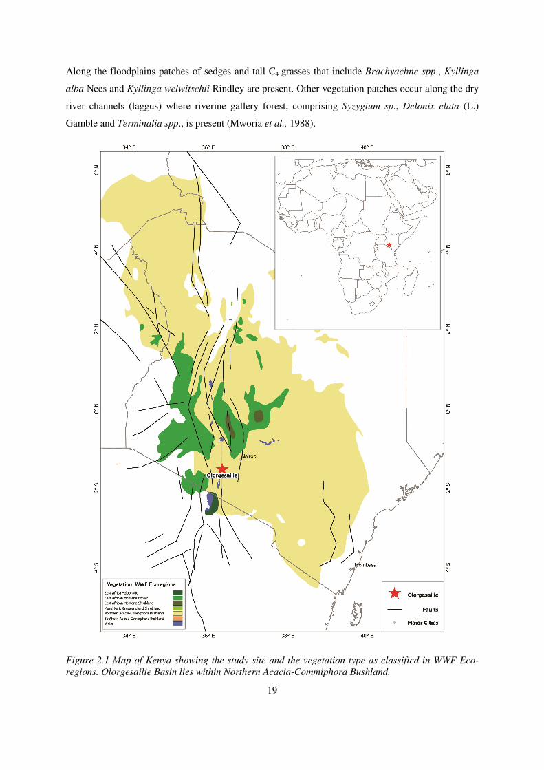
Figure 2.1 Map of Kenya showing the study site and the vegetation type as classified in WWF Eco-
regions. Olorgesailie Basin lies within Northern Acacia-Commiphora Bushland. ......................... 19
Figure 2.2 a. East African map showing the position of the July and January ITCZ, rift valley lakes
and study area; L. Turkana (1), L. Magadi (2), L. Natron (3), L. Victoria (4), L. Albert (5), L.
Tanganyika (6) and L. Malawi (7) (After Bergner et al., 2003). b. Map showing the distribution of
annual rainfall in Kenya, Olorgesailie receives 400-600 mm. ......................................................... 21
Figure 2.3 A Map showing Olorgesailie Formation in relation to other geological landforms (Deino
and Potts, 1992). .............................................................................................................................. 22
Figure 4.1 A geological trench (B05/04) showing samples taken (R19-R23) and the boundary between
Olorgesailie Formation and the Olkesiteti beds and geological marker tuff (225 ka) (Behrensmeyer
field notes). ...................................................................................................................................... 39
Figure 4.2 Reconstructed large-scale pattern of sediments accumulation through the past Million years
at the Olorgesailie Basin (after Behrensmeyer et al., 2002). ........................................................... 40
Figure 4.3 Olorgesailie Basin showing the three localities sampled for this study (Geological trenches
labelled in text boxes). ..................................................................................................................... 41
Figure 5.1 Graph showing the relative dominance of major grass morphotypes in four grass-sub-
families. See appendix II for the complete names of the morphotypes. .......................................... 68
Figure 5.2 shows a scatter plot obtained from correspondence analysis of 59 different phytolith
morphotypes (blue squares) identified from 69 plant species (red circles); Poaceae and non-
Poaceae families. ............................................................................................................................. 69
Figure 5.3 shows the scatter plot ordination obtained from correspondence analysis between grass
species (red circles) and corresponding grass short-cell phytoliths (blue squares). ........................ 71
Figure. 5.4 Cluster analysis dendrogram, wards linkage method and distance measure; Euclidean
Pythagorean, among phytolith morphotypes from all species combined. ....................................... 73
Figure 5.5 Cluster analysis dendrogram showing 27 grass morphotypes derived from 42 grass species.
......................................................................................................................................................... 73
Figure 6.1 Graph showing trend of grass phytolith indices over period between ~746 to~64 ka......... 77
Figure 6.2 Graph showing trend of dicot/ Poaceae index over a period between~746 to ~64 ka ......... 77
Figure 6.3 Phytolith diagram for Olorgesailie Basin. The abundance of each morphotype is expressed
as a percentage of the assemblage sum. ........................................................................................... 81
Figure 6.4 Phytolith spectra for Locality B. .......................................................................................... 84
Figure 6.6 Phytolith spectra for Locality G. ......................................................................................... 88

xii
List of plates
Plate 4.1- a) Bilobate panicoid type, b-c) bilobates convex outer margin short shaft, d-e quadralobate,
f) tower horned................................................................................................................................. 56
Plate 4.2-a-c) bilobate convex outer margin long shaft, d) bilobate concave outer margin short shaft,
e) saddle type, f) saddle squat. ........................................................................................................ 57
Plate 4.3-a) saddle ovate, b-c) tower wide, d) saddle plateau; e) epidermal crenate & saddle long at
top-right. .......................................................................................................................................... 58
Plate 4.4- a-b) tower wide, c) trapezoid polylobates, d) trapezoid e) saddles in situ; f) long cell sinuate
& bilobates convex outer margin long shaft. ................................................................................... 59
Plate 4.5-a) Irregular psilate; b) parallelepiped blocky psilate; c) long cells sinuate; d) spheroid
verrucate; e) silica skeletons elongate cells. .................................................................................... 60
Plate 4.6- a-b) Cyperus-silicified papillae; c) Cyperus-Achene type; d) Honeycomb assemblage; e)
spheroid echinate; f) spheroid psilate. ............................................................................................. 61
Plate 4.7 a-c) Schlereids; d-e) tracheids ................................................................................................ 62

xiii
List of Tables
Table 3.1 Environmental hypotheses of Hominin evolution (after Potts, 1998; Bobe and
Behrensmeyer, 2004)................................................................................................................26
Table 3.2 Summary of the vegetation reconstructed from major hominin sites in East Africa from
Plio-Pleistocene to early Pleistocene (Potts, 1998; Sikes, 1999; Albert et al., 2009)..............27
Table 3.3 Chronology of geological changes as inferred from Olorgesailie Formation (Potts,
1998).........................................................................................................................................30
Table 4.1 Plant species analysed, parts from which phytoliths were extracted, the site collected,
elevation range and habitats in which species is found in Kenya ............................................35
Table 4.2 Summary of major morph-types and the significance in this work.......................................44
Table 4.3 Phytolith Taxonomy, descriptors, corresponding figures and cited reference and codes used
for statistical analyses...............................................................................................................50
Table 8.1 Summary table of main morphotypes categories of significance in this study....................98

xiv
Abstract
Olorgesailie Basin is an important prehistoric locus and holds a prominent place in African
Quaternary research. It is located in the southern Kenya rift system (1˚ 35´S and 36˚ 27´E) and has
preserved numerous archaeological findings of the Acheulean, Sangoan and Middle Stone Age
occupations and most importantly, hominin cranium associated with the Acheulean hand axes.
Evidence of past vegetation has hitherto been scarce, because the arid / semi-arid conditions are not
conducive for preservation of organic plant microfossils. Phytolith analysis is used to reconstruct the
vegetation history and understand hominin habitat preference during mid-late Pleistocene (~746-64
ka).
A localised modern phytolith analogue is used to interpret the fossil assemblage. Descriptive analysis
identified fifty nine phytolith morphotypes which were categorised into three major groups; grass
short-cell phytolith, epidermal silicified appendages and sedge phytoliths. The identification and
classification was based on the International Code for Phytolith Nomenclature and other existing
literature.
In order to determine the significance of the identified morphotypes in interpreting fossil data, two
multivariate statistical analyses were performed on the database; Correspondence analysis
distinguished vegetation components according to a moisture gradient while Cluster analysis
identified unique morphotypes that were taxonomically affiliated to their parent plant species.
However, the analyses were not able to distinguish plants along the altitudinal gradient.
Fossil phytoliths derived from sixty palaeosol samples extracted from eight geological sections in
three localities of the Olorgesailie Basin, were identified and tallied to determine vegetation cover and
how this changed both spatially and temporarily during the mid-late Pleistocene period. Fossil
phytolith frequencies were plotted on TILIA diagrams against the available 40Ar/39Ar dates.
Correspondence analysis identified three vegetation components; grasslands, woody & herbaceous
and aquatic and identified moisture availability as the major underlying factor influencing the
morphotype clusters on the ordination space.
An additional cluster analysis of forty morphotypes derived from grasses confirmed the known
taxonomic affiliation of major grass short-cell phytoliths to four grass subfamilies (saddle ovate- C3
Arundinoideae, bilobate concave- and convex- outer margin short shaft and quadralobate-C4
Panicoideae, saddles-C4 Chloridoideae and bilobates convex outer margin long shaft-C4
Aristidoideae). From the non-grass category, achene and papillae phytolith morphotypes were
identified as belonging to the Cyperaceae.

xv
Palaeoenvironmental reconstruction based on fossil phytolith analyses suggested that vegetation cover
dominated was by tall moisture indicator grasses belonging to C3 Arundinoideae and C4 Panicoideae
sub-families during the mid-late Pleistocene period (~746-64 ka). Grass phytolith indices on the other
hand suggest warm and moist climates with subtle changes to dry and warm climates, while
dicotyledon versus Poaceae ratio suggest open-canopy vegetation structure dominated with
grasslands.
Palaeolandscapes bracketed between ~340 ka and 220 ka supported a heterogeneous vegetation cover
with the presence of riverine/riparian vegetation, open grasslands and wetlands (aquatics). This
suggests that the landscapes consisted of a mix of ecosystems that were ideal for early hominins
inhabiting the region during the mid-Pleistocene period.
This study demonstrates the potential of phytolith analysis as an important proxy in determining the
cover and composition of vegetation in the absence of other organic plant fossils. Although there were
limitations concerning the chronology of the available dates, the study has provided crucial
information for understanding the palaeoenvironments that existed in the Olorgesailie Basin and its
possible influence on the behaviour of early hominins during the Pleistocene period. This study offers
a base for other studies at archaeological sites which have limited preservation of organic plant
remains. The need for a clear chronology to aid in the interpretation of results is, however important.
Keywords: Olorgesailie; Phytolith; Correspondence Analysis; Cluster Analysis; Pleistocene;
Palaeoenvironments.

14
CHAPTER ONE: INTRODUCTION
1.1 INTRODUCTION
The Olorgesailie Basin (southern Kenyan Rift, 1˚ 35´S and 36˚ 27´E) is an important prehistoric locus
and holds a prominent place in African Quaternary research (Isaac, 1977; Potts, 1989; Deino and
Potts, 1990; Potts, 1994; 1998; Sikes et al., 1999). Hominin occupation in the area span the
Pleistocene epoch, and includes the Acheulean, Sangoan, and Middle Stone Age occupations. Since
the discovery of stone tools at the Olorgesailie Basin in 1942 by the Leakeys (Isaac, 1977), numerous
archaeological and geological studies have been carried out, the most remarkable being the geological
definition of the Olorgesailie formation (Isaac, 1977). Thereafter, from 1985 to the present, a team of
scientists from the Smithsonian Institution and the National Museums of Kenya, led by Prof. Rick
Potts, has been carrying out archaeological, geological and palaeoenvironmental studies on a
landscape scale with the aim of understanding in-depth human evolutionary history and how humans
interacted with the surrounding environment in the past (Potts et al., 1999; Sikes et al., 1999;
Behrensmeyer et al., 2002; Owen et al., 2008).
Although the geology and archaeology of the basin are well understood (Isaac, 1977; Potts, 1989;
1994; Potts et al., 1999) little is known of the palaeoenvironmental conditions that prevailed during
early human occupation (see Sikes et al., 1999; Owen et al., 2008). Attempts to investigate the
vegetation component of such palaeoenvironments are a step towards understanding the major drivers
of changes in the past ecosystems through time and across the landscape. This enables the separation
of changes due to climatic causes from those caused by anthropogenic activities, and provides an
indication of the habitat preferences of hominins at the time (Sikes et al., 1999). The study of plant
fossils, including pollen, has proved challenging due to poor preservation of organic plant remains
(Livingstone and Mworia, unpublished report with the National Museums of Kenya, Nairobi). In this
context, phytoliths provide an opportunity to investigate directly the vegetation context that existed in
the basin in the distant past.
Phytoliths are silica bodies that form as microscopic components of many vascular plants when
monosilicic acid from groundwater is precipitated as opaline silica in intra- and inter-cellular space
(Piperno, 1988). Deposition loci within the plant account for the variation in phytoliths morphologies
that are produced by specific plants. In addition, some phytoliths have shapes which are related to the
parent cell because they are deposited in the specialized silica accumulating cells of certain taxa
(Metcalfe, 1960; Piperno, 1988). Once the plants decompose, the silica bodies are released back to the

15
soils/sediments where they are preserved depending on environmental factors associated with the
deposition regime (Piperno, 2006).
Phytolith assemblages reflect the composition of different plant communities and, as such, may relate
to the different climatic conditions in which distinctive communities prevail (Bamford et al., 2006).
Climate plays a major role in determining how different vegetation types are distributed in different
ecosystems (Twiss et al., 1969) and varies along altitudinal gradients in relation to changes in
temperature and moisture (Tieszen et al., 1979; Mulholland, 1989; Mulholland and Rapp, 1992a).
Critically, phytolith spectra vary from one vegetation community to another. Furthermore, grass
phytoliths from grasslands growing under different climatic regimes also vary and therefore have been
used in phytolith research to trace sub-families and tribes associated with different moisture and
temperature regimes (Alexandre et al., 1997; Strömberg, 2004; Barboni et al., 2007; Barboni and
Bremond, 2009). Some studies have applied phytoliths to reconstruct grassland dynamics (Alexandre
et al., 1997; Strömberg, 2004; Thorn, 2004), to study vegetation canopies in terms of woody plant
density (Bremond et al., 2005a) as well as the vegetation context of human occupation (Mercader et
al., 2000; Bamford et al., 2006; Albert et al., 2009; Barboni et al., 2010).
This study applies the analyses of fossil phytolith assemblages extracted from palaeosols collected
from the Olorgesailie- and Post Olorgesailie- (Olkesiteti and Oltepesi beds) formations to determine
past vegetation cover and transition periods while relating the data to Hominin occupation and
behaviour within the basin as indicated by archaeological findings (for example, Potts, 1994; Potts et
al., 1999; Brooks et al., 2007).
1.2 Research objectives
The Olorgesailie Basin preserves human pre-history extending from the time immediately preceding
and including the evolutionary events that led to the transition of hominins from Homo erectus to
Homo sapiens in sub-Saharan Africa around 1.0 Ma-to ~0.6 Ma (Potts, 1989; Potts et al., 2004). It is
therefore a unique and important site in understanding human evolutionary history and, more
precisely, hominin-environment interactions. To understand the latter, it is important to know the
vegetation cover and associated palaeoenvironments that existed in the basin during this time period.
Although stable isotopic data from palaeosols (0.99 Ma) suggested that a mixed vegetation of woody
grasslands occurred across the landscape during the early Pleistocene (Sikes et al., 1999) changes in
vegetation cover in the region on temporal scale have not yet been established. Paleolimnological
studies, however, have indicated environmental fluctuations of wet and dry episodes on decadal-
centennial scale between early-mid Pleistocene (~1.2 Ma-~0.493 Ma) within the lake basin (Owen et

16
al., 2008). Against this background, this study examines the vegetation component of the past
environments of the basin, inferred directly from plant microfossils, in particular phytoliths. In
addition the research investigates both temporal and spatial vegetation changes and associated
climatic conditions during this important period of hominin evolution.
1.2.1 Aim and objectives
This project aims to establish the vegetation contexts of the Olorgesailie Basin and the surrounding
environments during the mid-late Pleistocene occupations. Trends in vegetation changes through the
said time period, as well as spatial heterogeneity, were investigated by extracting fossil phytoliths
from palaeosol strata of upper Members of the Olorgesailie Fm. and from Olkesiteti and Oltepesi
beds. The data were analysed to investigate the possible climatic conditions that prevailed during this
period and provide insights about the cover and the composition of environments within which early
hominins lived and interacted.
Fossil remains recovered from the site include mega fauna elements whose present habitats are
wooded grasslands, bushlands and forests. Given that the contemporary vegetation does not support
the existence of the large mammals, I therefore hypothesized that the vegetation has changed
significantly through time. In order to address the main question, the following objectives were
established;
a. To derive a modern phytolith analogue model from plants growing along an altitudinal/
climatic gradient represented by the Taita Hills (~1800 m a.s.l.), Olorgesailie Basin (~990 m
a.s.l.) and the Mt. Kenya region (> 2500 m a.s.l.).
b. To perform multivariate statistical analyses of the modern phytolith analogue to identify and
determine the extent to which certain morphotypes are related to particular vegetation types.
c. To establish changes in vegetation components over time during the relevant phases of the
Pleistocene period through fossil phytolith analysis thus enabling the key changes in woody
cover and riverine elements to be identified.
d. To interpret these changes in terms of changing temperatures and moisture conditions by
using climatic and aridity indices computed from C3/C4 grass short-cell phytolith proportions.
e. To examine the spatial variability of different vegetation types by comparing phytolith
assemblages from different locations within the basin.
f. To determine the significance of the reconstructed vegetation to hominin evolution and
habitat preference in the southern Rift Valley of Kenya.

17
1.3 Thesis structure
This chapter has provided a brief background and has highlighted the aims and objectives of the
study as well as the existing gaps in current knowledge that this research will address. Chapter 2
provides background information regarding the study site, including contemporary climate and
vegetation cover characteristics and the geological and archaeological context. Chapter 3 presents
a review of relevant palaeoenvironmental and paleoclimate literature of the East African region
in order to understand the context of past vegetation change as derived from phytolith analyses.
Chapters 4 and 5 outline the theories and methodologies applied to obtain both modern and fossil
phytolith data and summarises the technical approach used in the field and laboratory. These
chapters also describe the statistical analyses that were used to assess the modern phytolith
reference results in Chapter 6 and to interpret fossil phytolith assemblages derived from
palaeosols in chapter 7. Chapter 8 summarises and assesses the significance of the study in
relation to the aims and objectives. Appendices incorporate raw data and relevant information in
order to help the reader to further understand and interpret the research findings.

18
CHAPTER TWO: OLORGESAILIE
BASIN
2.1 INTRODUCTION
This chapter describes the geographical location of the study area, including physiographic, climatic,
geological and archaeological settings of the region.
2.1.1 Location and geology of the study Site
The Olorgesailie Basin (36˚ 27’E, 1˚ 34’S) is 150 km2 in extent. It is part of the “Gregory Rift”
(Gregory, 1921), and is located 110 km south west of Nairobi city, Kenya. The basin itself lies at 940-
1040 m above sea level. It was formed as a result of the tectonic upheavals in the area that
characterized the Cainozoic Era (Isaac, 1977; 1978; Potts, 1989; Behrensmeyer et al., 2002). Frequent
palaeo-physiogeographic changes have shifted deposition regimes and exposed sediments and their
fossil contents along the East Africa Rift Valley complex. The Olorgesailie Basin is one of many
such exposed localities (Isaac, 1977; 1978; see fig 2.1), and is one of the most important areas in
Africa for studies on human evolution and associated palaeoenvironments.
2.1.2 Current vegetation
The current vegetation is characterized as a semi-arid variant of the “Commiphora-Acacia” bushland
(White, 1983) also classified as Northern Acacia-Commiphora bushland (WWF Eco-regions; fig 2.1).
The dominant woody components in the bushland include Acacia tortilis (Forssk.) Hayne, A. Senegal
(L.)Willd., A. mellifera, Balanites spp. Grewia bicolor Juss., Grewia villosa Willd., Boscia coriacea
Pax, Salvadora persica L., Commiphora africana (A. Rich.) Engl., Terminalia sp. and C. campestris/
scheffleri Engl. The low shrubs constitute Sericocomopsis sp., Barleria sp., Aerva sp. and Indigofera
sp. Most of the trees are deciduous, and are only in leaf during and after the rainy season (Mworia et
al., 1988). The grasslands are dominated by the following species: Chloris roxburghiana Schult.,
Dactyloctenium bogdanii S. M. Phillips, Eragrostis cilianensis (All.) F. T. Hubb., Tetrapogon
cenchriformis (A. Rich.) W.D. Clayton and Sporobolus jacquemontii Kunth., all of which are C4
grasses.
The vegetation on the alluvial plains within the basin is relatively open compared to the surrounding
ridges and on Mt. Olorgesailie itself, and is mainly comprised of the C4 grasses that thrive well in hot
and dry climates. Mt. Olorgesailie and the surrounding ridges are characterised by bushes and small
deciduous trees dominated by Acacia mellifera, Commiphora campestris, C. africana and Terminalia
spp. (Mworia et al., 1988).
19
Along the floodplains patches of sedges and tall C4 grasses that include Brachyachne spp., Kyllinga
alba Nees and Kyllinga welwitschii Rindley are present. Other vegetation patches occur along the dry
river channels (laggus) where riverine gallery forest, comprising Syzygium sp., Delonix elata (L.)
Gamble and Terminalia spp., is present (Mworia et al., 1988).
Figure 2.1 Map of Kenya showing the study site and the vegetation type as classified in WWF Eco-
regions. Olorgesailie Basin lies within Northern Acacia-Commiphora Bushland.

20
2.1.3 Contemporary climate
East Africa lies within sub-tropical Africa, 20˚-30˚north and south of the equator. Its climate is
controlled largely by the sub-tropical high pressure cells as the Inter-Tropical Convergence Zone
(ITCZ) migrates from south to north, and vice versa following the sun’s Zenith point (fig 2.2a).
The passage of the ITCZ, a low pressure belt, northwards or southwards results in high rainfall belts
that correspond to the area of maximum insolation. The region influenced by the ITCZ lies between
the Tropic of Cancer in the Northern Hemisphere and Tropic of Capricon in the Southern
Hemisphere, approximately 23˚ 26’ 16” N/S (Hills, 1978). Climate variations due to latitude, distance
from the coast and topography are complex (Mutai and Ward, 2000; Marchant et al., 2006) and vary
strongly at the local scale.
Inter-annual rainfall variability in the region is influenced by disturbances in the monsoon and trade
winds, by changes in sea surface temperature (SST) and by large scale atmospheric weather patterns
(Mutai and Ward, 2000). Climates within the western part of East Africa are under the influence of
moist westerly winds originating from the South Atlantic through the Congo basin during the austral
winter (Kenworthy, 1966; Mutai and Ward, 2000).
Regions in the eastern rift valley are characterised by two rainy seasons which follow the equinoxes.
The long rains occur from March to June and short rains occur from October to December. Between
the two rainy seasons, two dry seasons occur which are described as being of short (July-September)
and long (December-February) duration (Sansom, 1954; Griffiths, 1958; 1972; Asani and Kinuthia,
1979). This bi-modal rainfall pattern is caused by the seasonal migration of the ITCZ (Kenworthy,
1966; Nicholson, 1996) and considerable local spatial variation results from moisture transported
from the Indian Ocean and/or from westerly winds from the Congo basin (Bergner et al., 2003, fig
2.2a). While the period of maximum rainfall follows the latitudinal position of the ITCZ with a time
lag of around four weeks, the maximum surface temperatures coincide with periods of maximum solar
radiation (Nicholson, 1996). Temporal rainfall anomalies are associated with the El Niño-Southern
Oscillation (ENSO); above average rainfall is associated with warm ENSO events while below
average rainfall is associated with cold ENSO events during the short rains. Mean rainfall totals are
highly spatially heterogeneous due to the topographical complexity of the region, resulting in varied
average annual rainfall in the highlands between 1000-1500 mm and, between 250-500 mm in the
lowlands (Griffiths, 1972; Mutai and Ward, 2000).
In the central Rift valley, the pattern is altered by the rain shadow effect of the mountain ranges
resulting in irregular rainfall during the long rainy season, March-May (Damnat and Taieb, 1995;
Mutai and Ward, 2000). The average rainfall around the Olorgesailie Basin is less than 500 mm per

21
annum (fig. 2.2b.) while the evapo-transpiration of the adjacent Lake Magadi is extremely high >2400
mm per annum (Damnat and Taieb 1995). This negative hydrological balance results in the formation
of an evaporite known as the trona crust (NaHCO3.Na2CO3.2H2O) which is mined from the lake for
economic purposes (Damnat and Taieb, 1995).
Figure 2.2 a. East African map showing the position of the July and January ITCZ, rift valley lakes
and study area; L. Turkana (1), L. Magadi (2), L. Natron (3), L. Victoria (4), L. Albert (5), L.
Tanganyika (6) and L. Malawi (7) (After Bergner et al., 2003). b. Map showing the distribution of
annual rainfall in Kenya, Olorgesailie receives 400-600 mm.
Variability in precipitation is one of the primary reasons for differences in natural vegetation, land
cover and land-use within the region (fig 2.2 b). For instance, agriculture is a prominent economic
activity in the highlands due to high annual rainfall, while in the lowlands, where the climate is arid to
semi-arid, the main economic activity is pastorlism.
2.1.4 Geo-archaeology
The Olorgesailie Basin is bounded by lavas associated with Mt. Olorgesailie, an extinct Pliocene
volcano to the south, and to the north, east and west, by faulted ridges and outcrops of the widespread
trachytes, phonolites and basalts (fig. 2.3), which were extruded during the subsiding trough of the
southern Kenya rift during the Plio-Pleistocene (Baker and Mitchel, 1976). The drainage system
within the basin is controlled by the gradual sloping of the rift floor from North to South over the last
million years (Behrensmeyer et al., 2002).

22
Figure 2.3 A Map showing Olorgesailie Formation in relation to other geological landforms (Deino
and Potts, 1992).
Three Formations have been identified within the Olorgesailie Basin according to their lithological
characteristics and stratigraphic position (Isaac, 1978); the Olorgesailie, Oltepesi and Olkesiteti
Formations. The Olorgesailie formation is comprised of a wide range of lacustrine, wetland/swampy,
fluvial and colluvial sedimentary facies that have an aggregate thickness of about 57-80m consisting
of Member 1 (oldest 900 ka) to Member 14 (youngest; 490 ka) (Isaac, 1977; 1978; Potts, 1989;
Behrensmeyer et al., 2002). The Formation has been dated by single-crystal of 40Ar/39Ar from 1200 ka
at the base of M-1 to 490 ka in Member 14 (Deino and Potts, 1990; 1992). The Oltepesi Formation,
on the other hand, consists of a distinctive suite of relatively fine-grained, buff-brown sands and silts,
re-worked tuffs and pumice gravels (Behrensmeyer et al., 2002).
Following an erosional unconformity, estimated to have occurred between 490 and 340 ka, sediments
that postdate the Olorgesailie Formation were deposited. These deposits mainly represent phases of
channel filling that were interspersed with periods of intensive fluvial down-cutting (Behrensmeyer,
2010 unpublished report). Although individual strata are difficult to trace over wide areas, the

23
sediments of the first two or more phases of channel filling (referred to as the Olkesiteti Fm.) preserve
a sequence of non-Acheulean and Middle Stone Age sites, which have been excavated in the basin in
Localities B and G (Brooks et al., 2007). Most of these sites, including the excavated areas sampled
for phytolith analysis in this study, underlie volcanic tephra with preliminary dates of 220 ka (Deino
and Potts, 1990; Potts, personal communication).
Acheulean hand axes are associated with the Legemunge beds, consisting of palaeosols and shallow
river channels (Isaac, 1977; Behrensmeyer et al., 2002). The highest concentration of archaeological
finds is in the upper Member 1 palaeosol (UM1p) with an altitude of 980 m a. s. l. This palaeosol age
has been established at 992±39 / 974±10 ka (Deino and Potts, 1990; 1992; see the map in fig. 2.3).
2.2 Summary
This chapter has presented the overview of the study site, the physiogeographical, geological and
archaeological settings which make Olorgesailie Basin an ideal site to investigate vegetation change
and spatial heterogeneity using phytolith analysis. Contemporary climates and vegetation cover is also
presented here to form a basis for comparison with the investigated past climates and vegetation
history. The following chapter provides a background to the literature of relevance to this study.

24
CHAPTER THREE: LITERATURE
REVIEW
3.1 INTRODUCTION
This chapter provides a background to literature pertaining to the study in two parts; 1) review of the
previous phytolith studies and their application in palaeoecological studies, particularly in Africa, and
2) review of human evolutionary studies undertaken in the East African region. Although the record
for Pleistocene environments is limited, the available information inferred from various proxies and
disciplines is reviewed here. Limnological and hydrological studies conducted in the Lake Naivasha
basin, located to the north of the Olorgesailie Basin in the central Kenyan Rift Valley is especially
relevant because the chronology established in those studies overlaps the dates for this study.
3.2 Phytolith analysis as a palaeoecological tool
Phytoliths are microscopic silica bodies produced by plants via the deposition of dissolved silica;
monosilicic acid [Si (OH) 4] within and between plants cells (Piperno, 1988, 2006; Pearsall, 1989;
Rapp and Mulholland, 1992a) during evapotranspiration. The degree to which plants produce
phytoliths is controlled by various factors which include: climatic conditions under which the plants
grow and mature, soil chemistry, soil water, plant developmental stage and the taxonomic affinity of
the plant (Piperno, 2006). Phytoliths, like pollen, are advantaged by various characters that qualify
them as index fossils (Faegri and Inversen, 1975; Moore and Webb, 1978). They preserve well under
oxidized conditions, hence are well preserved in dry environments where fossil pollen is absent
(Piperno, 2006). In addition, phytoliths have lower specific gravity ( than clastic silica, and
therefore can be successfully separated through heavy liquid floatation (Twiss et al., 1969; Rovner,
1971).
The history of phytolith studies has been summarised in various publications (see Mulholland and
Rapp Jr., 1992a; Sommer, 2003). Phytoliths were first recognised and described by Loeuwenhoek in
1675, in research relating phytoliths to plant anatomy and physiology, and they were subsequently
applied in reconstructing palaeoenvironments. The application of phytoliths in palaeocological studies
proved to be possible with systematic description of phytolith morphotypes, based on their anatomical
characteristics and their associations to various plant groups (Twiss et al., 1969).
Although most plants are thought to produce phytoliths, dicotyledons are known to be poor silica
accumulators while monocotyledons are regarded as the best accumulators; dicots in general produce
25
fewer phytoliths than monocots growing in the same environments (Piperno, 2006). More
importantly, grasses - being prolific silica accumulators - produce numerous distinctive phytoliths that
facilitate diagnosis beyond family level (Twiss, et al., 1969; Piperno and Pearsall, 1998; Mulholland
and Rapp, 1992b; Fahmy, 2008; Mercader et al., 2010) and have even proved to be potential tools in
grass systematics ( e.g. Ollendorf et al., 1988). Hence, phytoliths are more accurate for vegetation
reconstruction than grass pollen, which can only be distinguished to the family level. They also
provide gives valuable paleoclimate insights because of the association of various grass tribes with
specific moisture and temperature regimes.
Phytolith researchers apply both quantitative and qualitative analyses to clearly define and interpret
phytolith data for palaeocological purposes. In terms of climatic and vegetational aspects, estimates of
C3/C4 grass composition (grass phytolith indices) can provide information on possible climatic
conditions reflected in a given phytolith assemblage (Alexandre et al., 1997; Bremond et al., 2008),
while estimates of grasses/trees and shrub composition may help determine the relative extent of
closed or open habitats (Bremond et al., 2005a).
Apart from grasses, which are known to produce diagnostic morphotypes, other plants such as palms
and sedges which are usually associated with wetter habitats have proven useful in determining the
broad habitat characteristics of the area (Ollendorf, 1992; Runge, 1999; Piperno, 2001; Albert et al.,
2006; Barboni et al., 2010).
3.3 Environmental records in major hominin sites in East Africa
Detailed studies show that African climate and vegetation cover was highly variable from the early
Pliocene to the present. Research indicates that African climates at this time oscillated from warm and
humid to cool and dry episodes (deMenocal, 1995; deMenocal and Bloemendal, 1995). This resulted
in habitats varying between wooded vegetation to open savannah grasslands. It has been hypothesised
that this variability was an important factor driving the evolution and speciation of mammals
(Environmental Forcing Hypothesis; Bobe et al., 2002). Kingston et al. (1994) found the
palaeoenvironmental setting of the Kenyan rift was best described as “...a heterogeneous environment
with a mix of C3 and C4 plants that persisted for the last 15.5 Ma”. Other hypotheses based on
palaeoenvironmental changes, and associated with major fossil discoveries linked to human evolution
and their interactions with environmental context, are discussed and summarised by Potts (1998;
Table 3.1). Recent debate on the possible vegetation context in which Ardipithecus ramidus (Aramis
~4.4 Ma) interacted with the surrounding environments in Ethiopia (WoldeGabriel et al., 2009;
Cerling et al., 2010; White et al., 2010) is a perfect example that demonstrates the need for
paleovegetation data from African hominin sites.

26
3.3.1 Plio-Pleistocene environments
Regional palaeoenvironmental data linked to human evolutionary history have been studied from two
major sources; 1) Deep-sea sediment cores that contained a record of climate changes on both
regional (Maslin and Christen, 2007; Trauth et al., 2007) and global scales (deMenocal, 1995; 2004;
Scholz et al., 2007); and 2) Multi-disciplinary palaeoenvironmental analyses of major hominin sites
found predominantly in the African rift valley systems (see Vrba, 1995; White, 1995; Behrensmeyer
et al., 1997; Sikes et al., 1999; Albert et al., 2009; Bamford et al., 2006) which showed that, major
human evolution trajectories coincided with global climatic shifts (Potts, 1998). The interaction
between hominins and their surrounding environments, and the role of climate change in human
evolution have been discussed and summarised on millennial time-scales (Potts, 1998). Table 3.1
summarises the hypotheses relating to human evolutional and environmental change based on
different proxies (see Potts, 1998).
Table 3.1 Environmental hypotheses of hominin evolution (after Potts, 1998; Bobe and Behrensmeyer, 2004)
Hypothesis Theories (sources)
Savannah expansion
The expansion of grassland ecosystems in Africa coincides with important events of human evolution and major pulses of faunal turnover of mammalian taxa over a wide geographical scale (Vrba, 1985; Bobe et al., 2002; Bobe and Behrensmeyer, 2004). The idea links global climatic changes to faunal turnover and the emergence of the hominin Homo and Paranthropus (Vrba, 1985). The hypothesis was modified by linking shifts towards drier climates, and human evolution and migration on all time scales (deMenocal, 1995; Potts, 1998).
Turnover Pulse
Multiple episodes of high faunal turnover and increased number and abundance of grassland-adopted species, coincide with the appearance of Paranthropus, early Homo and Homo Erectus (Bobe and Behrensmeyer, 2004). Adaptation of bovid species to open grasslands, led to the evolution of new species (Vrba, 1995)
Variability selection
Fluctuating climates and environments, and not a directional trend, shaped human adaptation and evolution (Potts, 1996; 1998).
Great attention has been concentrated during the period when the genera Ardipithecus and
Australopithecus emerged in Africa about ~4.4 Ma and 3.6-1.2 Ma respectively as evidenced by
extensive studies in east African hominin sites, including those at Hadar and Middle Awash
(Ethiopia), Koobi-Fora (Kenya) and Olduvai Gorge (Tanzania) (WoldeGabriel et al., 1994; Asfaw et
al., 1999; Sikes et al., 1999; Blumenshine et al., 2003; Albert et al., 2006, 2009; Bamford et al., 2006;
White et al., 2006; 2010; Sikes and Ashley, 2007). In addition, recent studies from Olduvai Basin
studied phytoliths (among other proxies) to reconstruct palaeoenvironments associated with
Paranthropus boisei (Ashley et al., 2010).

27
A detailed chronology of human evolution with corresponding palaeoenvironments in East Africa (7.9
Ma-0.99 Ma) is presented in table 3.2 below (Albert et al., 2006; 2009; Bamford et al., 2006; Sikes et
al., 2007).
Table 3.2 Summary of the vegetation reconstructed from major hominin sites in East Africa from Plio-
Pleistocene to early Pleistocene (Bonnefille, 1984; Sikes et al., 1999 Albert et al., 2006; 2009) see detailed
references in (Potts, 1998).
Locality Age (Ma) Interpretation/ vegetation types Proxies
studied
Hypothesis /References
Olorgesailie ~0.99 Mixed vegetation, C4 grasslands and C3 plants
Stable isotopes from a single palaeosol
Adaptation to the mosaic (Sikes et al., 1999).
Olduvai Gorge
1.795-1.71
Gallery/riparian forests Plants microfossils & stable isotopes
Adaptation to fluctuations ( Bonnefille, 1984; Sikes, 1994)
Omo-Turkana 4.0-2.5 Dramatic floral change in gallery
forest.
Dry to wooded savannah and, gallery
forest
Plants
microfossils
Forest mosaic or fluctuations
Adaptation to mosaic
fluctuation (Bonnefille and
DeChamps, 1983)
Hadar 3.9-3.0 Forest/bush-open country-
grassy/plains-forest/bush
Fluctuation
(Bonnefille, 1995)
Laetoli 3.8-3.5 Open savannah with seasonal aridity
Woodland savannah
Adaptation to savannah
Adaptation to woodland
(Bonnefille and Riollet 1987).
Kanapoi 4.2-4.0 Mixed vegetation (C3 & C4 Plants)
Dry open vegetation
Forest-woodland
Mammalian
and isotopic
data
Adaptation to mosaic
Adaptation to Savannah
Adaptation to forest (Winkler,
1995; Leakey et al., 1995)
Aramis 4.4 Forest woodland Adaptation to forest (WoldeGabriel et al.,1994; White et al., 2010)
Tugen Hills 5.0-2.5 Mixed grassy woodland Mammalian and isotopic data
Adaptation to forest (Kingstone et al., 1994)
Kanam 6.1-3.5 Closed-open-closed vegetation Mixed vegetation (C3 & C4 Plants)
Fossil vertebrate and isotopic data
Fluctuation (Potts et al., 1997)
Lothagam 7.9-4.7 Mixed open woodland Mammalian and isotopic data
Adaptation to the mosaic (Leakey et al., 1996)
It is evident from table 3.2 that differences in methodological approach and hypotheses tested for each
hominin site has produced a wide range of results regarding vegetation structure and composition.
This can be partly attributed to the fact that most of the East African sites studied are preserved in

28
unstable fluvial sediments which are mainly localised resulting in differences in the proxies preserved
as well as the timeline recorded (Sikes, 1994). The application of a multi-proxy approach has proven
to be more accurate in reconstructing palaeoenvironments (Cerling et al., 2010; White et al., 2010),
yielding a more robust picture of vegetation change over time, on habitat scale/site specific scale.
Linking environmental findings across the landscape scale on a single sedimentary level within a site,
and across sites, would enable a more reliable synthesis of palaeoenvironmental reconstructions.
Synthesizing the available data from different localities within the East African region (Potts, 1998)
provides a clear chronological sequence of human evolutionary history and helps to identify the
remaining gaps that need to be addressed so as to fully understand hominin-environment interactions.
Geological studies from the Turkana basin suggest that during the Late Pliocene period (2.3-1.7 Ma),
the region underwent a series of major palaeogeographic changes which included the formation of rift
valley systems, uplifting of major volcanic landforms and the formation of the Rift Valley great lakes
(Feibel et al., 1991; Brown and Feibel, 1991; Feibel, 1999). During this time, paleontological and
archaeological evidence of patterns and spatial distribution of artefacts indicates that interactions
between toolmakers and the landscapes were altered, resulting in hominin tools being discarded in
different concentrations across diverse environments in the Turkana basin, as raw materials became
more or less available in response to changes in the river courses (Rogers et al., 1994). This is the
period when African Homo erectus (Homo ergaster, 1.88Ma) first appeared, and evidence of spatial
expansion of varied pattern of hominin activities were recorded (Potts, 1998). Ruff and Walker (1993)
concluded that the existence of H. ergaster may have marked a transition in climatic adaptation of
early hominins.
Records from Olduvai Gorge suggest that the basin was lake-dominated around 1.9-1.7 Ma (Walter et
al., 1991; Blumenshine and Masao, 1991; Bamford et al., 2006). Other multidisciplinary studies
suggest significant shifts of vegetation and climate over time, with wet, marshy woodland conditions
followed by dry conditions with sparse vegetation cover (Albert et al., 2009; Barboni et al., 2010).
Such climatic oscillations were also evidenced from the Turkana basin (Ruff and Walker, 1993). The
latter is further evidenced by the physiological characters of the Nariokotome skeleton (1.50-1.55 Ma)
whose body shape was linear, similar to modern humans living under a hot and dry climate and this
matches the arid and hot climate signalled in the Turkana and the Olduvai sequence at ~1.75 Ma (Ruff
and Walker, 1993).
Hominin fossils dated to the mid-Pleistocene period in Africa are rare, but one individual excavated
from the Olorgesailie Basin and identified as Homo erectus has been of great significance in
connecting human evolutionary clades in Africa (1.7-0.5 Ma). This individual is comparable to Asian
Homo erectus, which exhibits features that indicate morphological variations within Homo erectus

29
populations during this period that could probably be attributed to environmental instabilities (Potts et
al., 2004).
Previous studies have suggested that vegetation cover during the Pleistocene was more open and
characterised by a lower density of tree and shrub cover than the periods prior to 1 Ma, and that those
grasslands were persistent in the East African environments until perhaps as late as 600 ka (Potts,
1998, Bobe and Behrensmeyer, 2004). However, recent studies from the Koobi-Fora basin suggest an
earlier expansion of C4 grasslands between 2-1.75 Ma (Quinn et al., 2007) which concurs with a study
carried out from South African hominin sites (Lee-Thorp et al., 2007).
From the available literature, it is clear that the expansion and retreat of grasslands plays a major role
in defining changes in the environments in which hominins evolved (Bobe et al., 2002; Bobe and
Behrensmeyer, 2004). The evidence has been inferred mainly from carbon isotopic analysis, either
indirectly from herbivores or directly from soil organic carbon. However, very few isotopic data are
derived directly from grass remains, due to poor preservation of organic matter which is a major
challenge in most hominin sites. Further, it is impossible to identify grass pollen beyond family level,
making it difficult to distinguish grasses to sub families, tribes, sub-tribes or genus level which would
offer crucial information of the environmental and climatic conditions relating to the expansion of
grasslands (Metcalfe, 1960; Twiss et al., 1969; Twiss, 1992; Alexandre et al., 1997).
3.3.2 Palaeoenvironments within the Olorgesailie Basin
In the Olorgesailie Basin, initial paleovegetation studies have to date only been undertaken from the
upper Member 1-palaeosol of the Olorgesailie formation, dated to ~0.992 Ma (Sikes et al., 1997;
1999). Carbon isotopes (δ13C) indicate that the vegetation context for this palaeolandscape was
heterogeneous and consisted of wooded grasslands, and open savanna grasslands. Further, Oxygen
isotopes (δ 18 O) indicated local climates were cooler and wetter (Sikes et al., 1999) than present semi-
arid climates. In addition, research on hominin landscape use hypothesised that hominin-environment
interactions varied across the landscape according to the availability of food resources, raw materials
and security from predators in different vegetation elements. Such deductions are based on the
distribution pattern of artefacts and stone tools across the landscape (Potts et al., 1994, 1999).
Paleolimnological data (Owen et al., 2008) show high variability in water chemistry from fresh to
saline. The UM1p, in particular was dominated by swampy diatom floras, corresponding with the 1.1
-0.9 Ma high moisture phase recorded in rift valley lakes (Trauth et al., 2005).
Sedimentological studies revealed that the basin was subjected to two major geological processes;
first a tectonically stable deposition of lacustrine vs. sub aerial sediments (992-974 ka) (Trauth et al.,
2005) and second, a tectonically active basin characterised by erosional and depositional processes

30
(~974-780 ka) (Potts et al., 1999). The first phase was purely controlled by tectonic processes while
the second phase appears to have been a result of the combination of climatic fluctuations and tectonic
activity (Behrensmeyer et al., 2002). Table 3.3 gives a chronology of geological events recorded in
the Olorgesailie formation (~992-493 ka).
Table 3.3 Chronology of geological changes as inferred from the Olorgesailie Formation (Potts, 1998).
Members Age
Estimates
Environmental context/ major events
13-14 601-493 ka Two major environmental shifts are discussed to have caused “extensive and recurrent alteration
of the hydrology and the landscape”( Potts, 1998) and expansion of grasslands was recorded
(Sikes et al., 1997)
10-12 662-601 ka Disappearance-reappearance-expansion of the lake
8-9 780-662 ka
Three major shifts in deposition and hydrological regimes
6-7 974-780 ka Fluvial environment
Fluctuating lake margin
Stable vegetated environment
Soil formation in Upper Member 7
1-5 992-974 ka Lake establishment in M1
Lake margin fluctuation
Extensive studies have been undertaken on the archaeology of the basin which represent different
time periods (Potts, 1998; Potts et al., 1999; Brooks et al., 2007), but palaeoenvironmental studies are
scarce and have only been carried out on selected palaeosols of the Olorgesailie Formation. There are
no such studies from the post-Olorgesailie Formation (Olkesiteti and Oltepesi beds).
3.4 Climatic records in the rift valley region during the Pleistocene period
Multidisciplinary and multi proxy studies from the East African rift valley system suggest that the
climate in the Plio-Pleistocene to the Pleistocene period was influenced by major internal (tectonic)
and external (Orbital forcing) factors (Kingston et al., 2007; Lepre et al., 2007; Quinn et al., 2007;
Scholze et al., 2007; Trauth et al., 2007). The rift valley lakes show evidence of major global events
at 2.7 Ma (intensification of Northern Hemisphere Glaciations), 1.9 Ma (onset of Walker Circulation)
and ~1 Ma (Mid-Pleistocene Revolution) which was controlled by precessional forcing of moisture
availability in the tropics (Trauth et al., 2007).
Although signals and /or responses of climate change in the East African region vary greatly on a
regional scale due to differences in the driving factors (e.g. tectonic processes forcing in the northern
rift valley may differ from the southern forcing causing differential feedbacks), global climatic events

31
are well recorded across the region. Furthermore, when appropriate temporal and spatial scales are
considered, long-term and short-term processes have been identified with corresponding response
scale, i.e., global, regional or local responses (Maslin and Christensen, 2007). These feedbacks that
are well-documented from the East African rift valley are complex, as discussed below.
Strong evidence of extreme climate variability (extreme alternating wet and dry periods) may have
greatly influenced vegetation dynamics in the East African region during the Plio-Pleistocene (Lepre
et al., 2007; Maslin et al., 2007, 2009; Trauth et al., 2007), which in turn triggered the evolution of
hominins through the acquisition of adaptation traits (Potts, 2002).
Lithostratigraphic and sedimentological analyses from the Hadar formation, in Ethiopia show high
climate variability oscillating between warm and moist to extreme dry and cold phases ~3 Ma
(Campsiano and Feibel, 2007; Maslin and Christensen, 2007). Such dry episodes have been reflected
by the morphological features observed on Australopithecus afarensis and the associated faunal
remains which suggested arid open environments during the same period ~3 Ma (WoldeGabriel et al.,
1993; Campisano and Feibel, 2007) while in South Africa expansion of grasslands is evidenced
through isotopic analyses on the proportion of C3, mixed and C4 vegetation feeders (Lee-Thorp et al.,
2007).
Between 2.7-2.55 Ma, marked lake-level changes coinciding with Milankovitch precessional forcing
(23 ka- cycle), were suggested from Lake Baringo (central Kenyan rift valley) causing fragmentation
of biological communities, dispersal and then speciation of diatom flora (Kingstone et al., 2007).
Between 1.9-1.7 Ma, evidence from the Koobi-Fora formation suggests remarkable lake level
fluctuations in the Turkana basin, Kenya (Brown and Feibel, 1991; Lepre et al., 2007), while a short-
term wet episode has been recorded in the Shungura and Hadar formations in Ethiopia, Olduvai Gorge
in Tanzania and in the Olorgesailie Basin of Kenya, linked to the precessional orbital forcing. More
evidence from Olorgesailie, Naivasha and Elmentaita-Nakuru basins show the existence of large lakes
between 1.1-0.9 Ma, suggesting wetter conditions (Maslin and Christensen, 2007; Sikes and Ashley,
2007; Trauth et al., 2007; Owen et al., 2008).
Between 900-650 ka, records based on climate model analysis/time series, applied to benthic
(foraminifera) oxygen isotopes (δ18O) show intensification of glacial-interglacial climate cycles in
response to the obliquity orbital periodicities of 41 ka cycle around 600 ka (Muldelsee and
Stattegger,1997) resulting in the Mid-Pleistocene climate transition, known as the Mid-Pleistocene
Revolution (MPR). This global event impacted significantly on the African climate, leading to open
vegetation cover dominated by C4 grasslands in East Africa (Schefuβ et al., 2003), associated with
increased aridity.

32
Long lacustrine sediment records from Lake Malawi recorded extreme dry episodes between 135-75
ka, which were more severe than conditions in the Last Glacial Maximum (~18 ka ago) when the
water level of most of African great lakes was reduced (Lake Malawi, Lake Tanganyika and Lake
Bosumtwi) by at least 95% (Scholz et al., 2007). The climate then shifted to more stable but humid
conditions, evidenced by a rise in lake level which coincide with the reduction in precession
influenced climates and diminished orbital eccentricity at around 70 ka in the African tropics (Scholz
et al., 2007). This corresponds to findings from Lake Naivasha sediments during the last interglacial
(130-117 ka) and glacial (117-60 ka) cycles, which recorded high lake levels during 135 ka, 110 ka,
90 ka and 60 ka influenced by orbital oscillations (Trauth et al., 2001; 2003). This climate variability
is suggested to have played a major role in influencing human evolution in Africa (Trauth et al 2001;
Bobe and Behrensmeyer, 2004; Scholz et al 2007).
As indicated in Maslin and Christensen,(2007) ~80% (12 out of 15 specimens) of hominin species
found in East Africa date between 0.5-5.0 Ma, a period when East Africa experienced extremely
variable climates oscillating between wet and dry periods (Potts et al., 2004; White et al., 2006,
Maslin and Christensen, 2007). This further strengthens the evidence of variable climates as the major
driver of hominin evolution as evidenced by the emergence of Homo erectus in East Africa (Potts et
al., 2004; Lepre et al., 2007) graded as premodern Homo and hypothesized as closely related to the
modern Homo in the Linnaean hierarchy.
The literature and the evidence of past environmental changes suggest that drastic climate change
influenced the distribution of vegetation cover in East Africa, which consequently influenced the
occupants of these environments. However, the Olorgesailie Basin, a unique and important hominin
site with an excellent record of hominin activities, needs palaeoenvironmental data relating to
hominin specimens dating to 0.97-0.90 Ma (Potts et al., 2004). This information further bridges the
gap which remains in our understanding of hominin-environment-interactions in the South rift valley.
In this study phytolith analysis is undertaken for the mid-late Pleistocene palaeosols in order to
reconstruct the vegetation context of hominin activities. Use of fossil phytoliths not only indicates the
major vegetation components but also suggests the associated prevailing climatic conditions that
might have prevailed at the time (Alexandre et al., 1997; Bremond et al., 2008). In order to answer the
questions of this study, region-based phytolith data was collected and analysed using materials and
methods as presented in the following chapter.
33
CHAPTER FOUR: MATERIALS AND
METHODS
4.1 INTRODUCTION
The study of fossil phytolith assemblages as a proxy for reconstructing past vegetation and its likely
associated climatic correlates requires both quantitative and qualitative analyses, achieved by
analysing region-specific modern phytolith morphotypes (modern analogues). There are
methodological limitations of phytolith analysis due to multiplicity (whereby a single species
produces a range of phytolith morphotypes in different plant cells) and redundancy, (whereby
different plant species produce identical or indistinguishable phytolith morphotypes (e.g. Rovner
1971; Fredlund and Tieszen, 1994), but these challenges can be minimised in order to accurately
define and interpret phytolith-based palaeoecological data, by considering the following key factors:
1) a modern reference collection for the plants in the area under investigation; 2) a clear
understanding of the taphonomical processes to which the soils/sediment have been subjected; and 3)
phytolith composition derived from vegetation components known to thrive well under specific
climatic conditions.
The Olorgesailie deposits were formed under a variety of environmental conditions, including
terrestrial settings associated with soil formation, fluvial situations, swamps, lake marginal wetlands
and lakes of varying sizes, water depth and chemistry. It can be assumed that these different
environments have each been associated with different vegetation cover types and that the extent of
wetland habitats depends to some extent on regional climate as well as local hydrology and
topography. Therefore, the potential of phytolith analysis as a palaeoecological proxy is governed by
environmental factors and other factors outlined below:-
• Variation in phytolith production within plant species and among plant species,
• Differential preservation of plant taxa and their associated phytoliths (affecting the
interpretation of phytolith assemblages),
• Taxonomic significance of phytoliths,
• Dispersal mode and the possible extent to which phytoliths are transported from the source,
• Taphonomical issues (differential phytolith preservation and resistance to destruction in soils
and sediments).

34
This study places emphasis on the composition and frequency of phytoliths produced by grasses of
various tribes, and sedges, versus those produced by woody plants. This is because different phytolith
morphotypes are associated with specific grass tribes and also different grass tribes are associated
with contemporary climate and altitude, as observed in the field, making it possible to accurately
interpret past climatic conditions, which is a major question in this research project (Mulholland and
Rapp, 1992; Ollendorf, 1992; Twiss, 1992; Alexandre et al., 1997; Thorn, 2004; Barboni et al., 2007;
Bremond et al., 2008; Mercader et al., 2010; 2011) and understand how past human-environment
interactions developed (Piperno et al., 1990, Piperno, 1994; Kealhofer et al., 1999; Mercader et al.,
2000; Albert et al., 2005),. Distribution of grasses is highly controlled by climatic conditions,
specifically temperature gradient and soil moisture availability; C3 grasses [say which tribes, so that it
is consistent with the sentences below] thrive well under cool climates and in tropical Africa on high
altitudes >3000 m a.s.l. while C4 grasses thrive well in warm climates that could be either wet (e.g.
Panicoideae grasses) or dry (e.g. Chloridoideae grasses) (Twiss, 1992; Tieszen et al., 1979).
4.2 Materials
Materials collected and analysed in this study belonged to two major categories; modern plant
specimens for the reference collection and sediment samples for the fossil assemblages.
4.2.1 Reference collection
Plants differ greatly in their ability to produce phytoliths although many angiosperms, gymnosperms
and pteridophytes produce large quantities of phytoliths. Such ability is believed to be genetically
controlled and related to plant metabolic factors; consequently plants can either be silica accumulators
or non-accumulators (Piperno et al., 2002; Piperno, 2006). More importantly, plant species belonging
to the same family tend to have a similar silica accumulation pattern, hence similar phytolith
production (e.g., Bozarth, 1993a; Piperno, 1998; 2006; Blinnikov et al., 2002).
By creating a modern reference collection, an assessment of the potential of different plant species in
phytolith production may be established. For the species studied, information on the physiogeographic
distribution, ecological habitats and photosynthetic pathways (in the case of grasses) was considered
(Haines and Lye, 1983; Ibrahim and Kabuye, 1987; Agnew and Agnew, 1994; Beentje, 1994). In the
eastern Africa region, major Poaceae subfamilies are associated with particular environmental
conditions; C3 cool and moist (Pooideae), C3 moisture indicator grasses (Arundinoideae), C4 warm
and humid environments (Panicoideae) and C4 dry and hot environments (Chloridoideae,
Aristidoideae) (Fredlund and Tieszen 1994; 1997; Alexandre et al 1997; Bremond et al 2005 a, b;
2008; Barboni and Bremond, 2009). More so, different subfamilies produce higher percentages of
particular morphotypes (Twiss, et al., 1969); hence the relative abundance of each category within a

35
sample is indicative of which sub-family dominated the vegetation cover at the time of deposition
(Twiss, 1992; Alexandre et al., 1997; Barboni and Bremond, 2009). The relative composition of C3
versus C4 grasses can therefore give estimates of the prevailing climatic conditions (Alexandre et al.,
1997; Bremond et al., 2005a, b; 2008).
4.2.1.1 Sampling procedures
The selection of plants was based on both the contemporary vegetation in the region and the
archaeological data documented from the site, which included fossil remains of terrestrial mega-fauna
and fossil diatoms analysis indicative of environmental variability in the Pleistocene landscape (Potts
et al., 1999; Owen et al., 2008). Woody plants, grasses and sedges representing both C4 and C3 plants
species were sampled (Table 4.1). Plant identification was carried out at the Botany Department of the
National Museums of Kenya (Dr. Mwachala et. colleagues).
Random sampling of plant species representative of varied altitudinal range between 0-3000 m a.s.l
from the Taita hills, Olorgesailie Basin and Mt, Kenya was conducted. In all, 69 different plant
individuals were collected from two different vegetation types; the Olorgesailie Basin (~900-1100 m
a. s. l.) represented savannah vegetation types while the Taita hills (~0-1800 m a. s. l.) and Mt. Kenya
(>2500 m a. s. l.) regions represented dry and moist forest respectively.
Table 4.1 Plant species analysed, from which phytoliths were extracted, elevation range and habitats in which
the species are found in Kenya (Haines and Lye, 1983; Ibrahim and Kabuye, 1987; Agnew and Agnew, 1994;
Beentje, 1994).
Family Species Plant part Habitats/altitude range
Acanthaceae Acanthus eminence
stem, flowers, roots
Moist or dry forest, also among bamboo 1500-2800 m (Mt. Kenya)
Acanthaceae Barleria taitensis Complete Dry Acacia-Commiphora bush and Rocky bushland. 500-1050 m (Taita Hills)
Anarcadiaceae Rhus natalensis
stem, leaves, fruits
Dry forest margins, (semi-)evergreen bush land, thickets and wooded grasslands. 1050-2700 m (Mt. Kenya)
Anarcadiaceae Rhus vulgaris leaves, stem
Dry forest margins, (semi-)evergreen bush land, thickets and wooded grasslands 1200-2700 m (Mt. Kenya)
Anthericaceae Anthericum sp stem, roots 1980-2450 m (Mt, Kenya)
Asteraceae Vernonia brachycalyx
Leaves, Flowers
Dry forest edges ~1100 m (Olorgesailie)
Capparaceae n/a stem, leaves ~990 m (Olorgesailie)
Cyperaceae Cyperus sp Complete 930-2000 m (Olorgesailie)
Cyperaceae Cyperus papyrus Flower 650-2000 m (Olorgesailie) swampy areas
Cyperaceae Eleocharis sp Complete 950-1200 m (Olorgesailie) marshes at low altitudes
Cyperaceae Kyillinga sp
stem, leaves, flowers,
1140-1500 m (Mt Kenya) Moist soils, forest edges
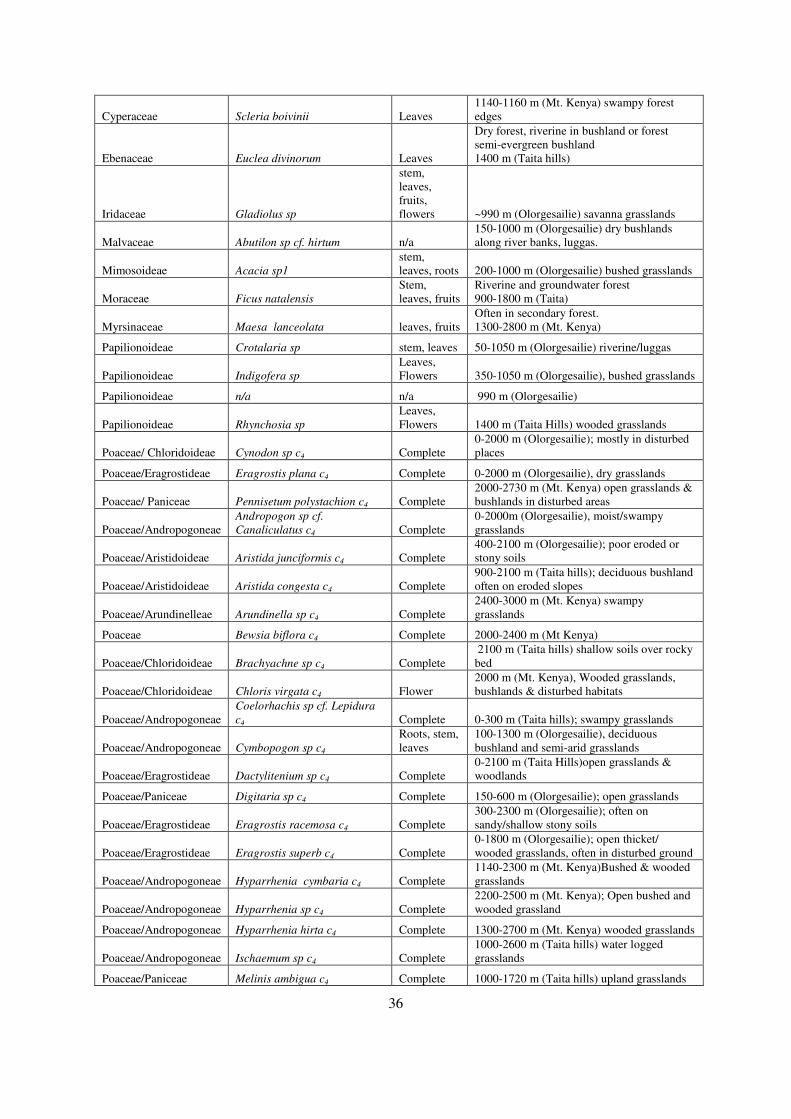
36
Cyperaceae Scleria boivinii Leaves 1140-1160 m (Mt. Kenya) swampy forest edges
Ebenaceae Euclea divinorum Leaves
Dry forest, riverine in bushland or forest semi-evergreen bushland 1400 m (Taita hills)
Iridaceae Gladiolus sp
stem, leaves, fruits, flowers ~990 m (Olorgesailie) savanna grasslands
Malvaceae Abutilon sp cf. hirtum n/a 150-1000 m (Olorgesailie) dry bushlands along river banks, luggas.
Mimosoideae Acacia sp1
stem, leaves, roots 200-1000 m (Olorgesailie) bushed grasslands
Moraceae Ficus natalensis
Stem, leaves, fruits
Riverine and groundwater forest 900-1800 m (Taita)
Myrsinaceae Maesa lanceolata leaves, fruits Often in secondary forest. 1300-2800 m (Mt. Kenya)
Papilionoideae Crotalaria sp stem, leaves 50-1050 m (Olorgesailie) riverine/luggas
Papilionoideae Indigofera sp
Leaves, Flowers 350-1050 m (Olorgesailie), bushed grasslands
Papilionoideae n/a n/a 990 m (Olorgesailie)
Papilionoideae Rhynchosia sp
Leaves, Flowers 1400 m (Taita Hills) wooded grasslands
Poaceae/ Chloridoideae Cynodon sp c4 Complete 0-2000 m (Olorgesailie); mostly in disturbed places
Poaceae/Eragrostideae Eragrostis plana c4 Complete 0-2000 m (Olorgesailie), dry grasslands
Poaceae/ Paniceae Pennisetum polystachion c4 Complete 2000-2730 m (Mt. Kenya) open grasslands & bushlands in disturbed areas
Poaceae/Andropogoneae Andropogon sp cf.
Canaliculatus c4 Complete 0-2000m (Olorgesailie), moist/swampy grasslands
Poaceae/Aristidoideae Aristida junciformis c4 Complete 400-2100 m (Olorgesailie); poor eroded or stony soils
Poaceae/Aristidoideae Aristida congesta c4 Complete 900-2100 m (Taita hills); deciduous bushland often on eroded slopes
Poaceae/Arundinelleae Arundinella sp c4 Complete 2400-3000 m (Mt. Kenya) swampy grasslands
Poaceae Bewsia biflora c4 Complete 2000-2400 m (Mt Kenya)
Poaceae/Chloridoideae Brachyachne sp c4 Complete 2100 m (Taita hills) shallow soils over rocky bed
Poaceae/Chloridoideae Chloris virgata c4 Flower 2000 m (Mt. Kenya), Wooded grasslands, bushlands & disturbed habitats
Poaceae/Andropogoneae Coelorhachis sp cf. Lepidura
c4 Complete 0-300 m (Taita hills); swampy grasslands
Poaceae/Andropogoneae Cymbopogon sp c4
Roots, stem, leaves
100-1300 m (Olorgesailie), deciduous bushland and semi-arid grasslands
Poaceae/Eragrostideae Dactylitenium sp c4 Complete 0-2100 m (Taita Hills)open grasslands & woodlands
Poaceae/Paniceae Digitaria sp c4 Complete 150-600 m (Olorgesailie); open grasslands
Poaceae/Eragrostideae Eragrostis racemosa c4 Complete 300-2300 m (Olorgesailie); often on sandy/shallow stony soils
Poaceae/Eragrostideae Eragrostis superb c4 Complete 0-1800 m (Olorgesailie); open thicket/ wooded grasslands, often in disturbed ground
Poaceae/Andropogoneae Hyparrhenia cymbaria c4 Complete 1140-2300 m (Mt. Kenya)Bushed & wooded grasslands
Poaceae/Andropogoneae Hyparrhenia sp c4 Complete 2200-2500 m (Mt. Kenya); Open bushed and wooded grassland
Poaceae/Andropogoneae Hyparrhenia hirta c4 Complete 1300-2700 m (Mt. Kenya) wooded grasslands
Poaceae/Andropogoneae Ischaemum sp c4 Complete 1000-2600 m (Taita hills) water logged grasslands
Poaceae/Paniceae Melinis ambigua c4 Complete 1000-1720 m (Taita hills) upland grasslands

37
Poaceae/Paniceae Melinis sp c4 Complete 1000-1720 m (Taita hills) grasslands
Poaceae/ Paniceae Melinis repens c4 Complete 930-2520 m (Mt, Kenya)wooded grasslands
Poaceae/ Paniceae Melinis nerviglumis c4 Complete 930-2520 m (Mt, Kenya) wooded grasslands
Poaceae/ Paniceae Oplismenus sp c4 Complete 0-2300 m (Mt. Kenya) forest
Poaceae/ Paniceae Panicum sp cf.eickii c4 Complete 2800 m (Mt. Kenya) Forest edges, swamp grasslands (uplands)
Poaceae/ Paniceae Panicum maximum c4 Complete 0-2400 m (Olorgesailie) wooded grasslands, forest edges
Poaceae/ Paniceae Pennisetum purpureum c4 Complete 0-2000 m (Mt. Kenya) Forest margins & riverine
Poaceae/Arundineae Phragmites mauritianus c3 Complete 0-1500 m (Taita hills), shallow water streams, river banks & lakes, and swampy places
Poaceae/Arundineae Phragmites australis c3 Complete
600-1500 m (Taita hills) shallow water streams, river & lake banks, in swampy places.
Poaceae/Andropogoneae Rottboellia sp c4 Complete 0-1700 m (Olorgesailie) flood plains
Poaceae/Andropogoneae Schizachyrium jeffreysii c4 Complete 0-900 m (Olorgesailie) wooded grasslands on moist places
Poaceae/Andropogoneae Schizachyrium sp c4 Complete 0-900 m (Olorgesailie) along stream banks
Poaceae/Paniceae Setaria sphacelata c4 Complete 0-3300 m (Mt. Kenya) grasslands & bushlands, stony hillside to river banks
Poaceae/Paniceae Setaria sp c4 Complete 0-3300 m (Mt. Kenya) Bushed-grasslands
Poaceae/Sporoboleae Sporobulus sp c4 Complete 1300-2600 m (Mt. Kenya) Deciduous bushlands
Poaceae/Sporoboleae Sporobulus africanus c4 Complete 1300-2600 m (Mt. Kenya), disturbed grounds/alongside paths
Poaceae/Sporoboleae Sporobulus consimilis c4 Complete 390-1950 m (Mt Kenya) flood plains and lake shores
Poaceae/Andropogoneae Themeda sp c4 Complete 0-3200 m (Mt. Kenya) open grasslands
Poaceae/Andropogoneae Themeda triadra c4 Complete 0-3200 m (Mt. Kenya) Deciduous bushland/wooded grasslands.
Poaceae/Paniceae Urochloa sp cf.
mosambicensis c4 Complete 0-650 m (Taita hills), Bush-grasslands on flood plains
Rubiaceae Canthium sp
Stem, leaves, fruits. 1700-2350 m (Mt. Kenya) upland forest
Rubiaceae Rubus sp
Leaves, Flowers 1950-2750 m (Mt. Kenya) upland forest
Rubiaceae Tarenna graveolens
Stem, leaves, fruits
Bushland, drier forest margins, thickets (often riverine), bushed grassland
Salvadoraceae Salvadora persica leaves, fruits
More often along laggus, lakes or wells; also in dry (Acacia) bushland and (wooded) grassland.
Tiliaceae Grewia fallax leaves Dry bushland or bushed grasslands, often in rocky sites near laggus or rivers.
4.2.1.2 Extracting Phytoliths from modern plants
The extraction of phytoliths from plant specimens followed a modified Albert and Weiner protocol
(after Mercader et al., 2009) which ensures both quantitative and qualitative data is obtained
(Strömberg, 2009). Although the determination of silica accumulation among plants is beyond the
scope of this research, the data base obtained can be used for future phytolith research.
Plant specimens were soaked in 5% Calgon solution overnight on an automatic shaker to loosen
unwanted material adhering to the specimens. They were then washed with distilled water through a

38
1mm sieve after which they were sonicated for 30min using a Fisher Scientific FS 60. The specimens
were then dried overnight at 100ºC, weighed and ashed in the muffle furnace at 500ºC for 12 hrs;
some woody specimens were ashed for up to 36hrs to achieve complete combustion.
The weight of the cooled dry ash was then recorded for each specimen to determine the proportion of
combustible carbon. The ash was transferred into test tubes where 10ml of equivolume solution of
Hydrochloric acid (HCl) and Nitric acid (HNO3) was added (at 3N)1. This was then boiled until the
residue formed a paste. The samples were then washed three times with distilled water each time
centrifuging at 3000 rpm for 5min. 10ml of Hydrogen peroxide (H2O2) was added to each sample,
which were then transferred into petri dishes, and placed on hot plate at 70ºC until the reaction ceased.
The samples were transferred back to the test tubes, washed with distilled water three times at 3000
rpm for 5min before drying in the oven at >100ºC. The resulting Acid Insoluble Fraction (AIF) was
weighed and stored in vials ready for slide mounting and analyses.
4.2.2 Soils and sediments
Phytolith preservation is highly dependent on taphonomical. In the Olorgesailie Basin, they include a
wide range of fluvial and colluvial depositional processes influenced by chemical and physical
weathering; such processes may be local, extra-local or regional to the basin (Isaac, 1977;
Behrensmeyer et al., 2002)..
4.2.2.1 Chronology and sampling procedures
The Olorgesailie Basin has been subjected to a variety of geological processes leading to four major
depositional phases in an ~120 m profile of sediments spanning the past million years, calibrated by
radiometric dating of volcanic ashes and pumices (Deino and Potts, 1990; 1992). The oldest of the
four phases of basin filling is represented by the Olorgesailie Formation which comprises sediments
~80 m in thickness dating between 992-493 ka (Deino and Potts, 1990). This formation consists of 14
Members that are well exposed across the southern part of the basin (Deino and Potts, 1990; Potts et
al., 1999; Behrensmeyer et al., 2002). Three samples collected from different palaeosols (~662-601
ka) in this formation were processed and analysed for phytoliths (fig 4.1 Geological section # B05/04;
225 ka tuff). Overlying the Olorgesailie formation are more localised deposits, ~40 m in thickness,
representing at least three episodes of valley cutting and filling that occurred between ~0.5 Ma and the
end of the late Pleistocene (fig 4.2). These deposits were identified as the Olkesiteti and Oltepesi beds
respectively (Isaac, 1978; Behrensmeyer et al., 2002).
1 1N means; 1g equivalent to 5 solutes per litre of solution.

39
Figure 4.1 A geological trench (B05/04) showing samples taken (R19-R23) and the boundary between
Olorgesailie Formation and the Olkesiteti beds and geological marker tuff (225 ka) (Behrensmeyer
field notes).

40
Unlike the Olorgesailie formation, where clear lateral correlation has been successfully carried out
through geological markers such as tuff, pumice (Deino and Potts, 1990) and chemical “fingerprints”
of the volcanic ashes (Behrensmeyer et al., 2002), the Olkesiteti and Oltepesi beds are more
complicated due to the alteration of their geomorphology by faulting and volcanic flows in the Late
Pleistocene (Baker and Mitchell, 1976). The Olkesiteti bed dates between ~340 -220 ka (Deino and
Potts, 1992) while the later Oltepesi deposits date to ~105-64 ka. The two beds form the post-
Olorgesailie formation referred to ‘The New Formation’ shown in fig 4.2 which currently is being
mapped (ongoing geological mapping by Behrensmeyer et al., 2010).
Figure 4.2 Reconstructed large-scale pattern of sediments accumulation through the past Million
years at the Olorgesailie Basin (after Behrensmeyer et al., 2002).
4.2.2.2 Target palaeosol
All samples were collected from stratigraphic intervals identified as palaeosols. Twenty six that were
vertically matched with chronological sequences from four geological sections in Locality B were
processed for phytolith analysis (see map in fig 4.3), these sections are described below from the
youngest deposits to the oldest,
A) Geological Section B08/05 (~3.5 m thick)
This section constitutes deposits including the dated tuff ~225 ka; of the New Formation. The base of
the deposit is on Olorgesailie formation M11; five samples were collected within a 2 m depth from the
dated tuff while seven samples were collected above the tuff ~2.5 m. One of the samples was
collected from palaeosol~ 3.5 cm from the 225 ka tuff.

41
B) Geological Section B06/04 (~2.5 m thick)
This section constitutes deposits of the New Formation; Olkesiteti and Oltepesi beds. All the deposits
are above the dated pumice gravel ~340 ka and below the volcanic tuff ~225 ka. Six samples were
collected from this section, three of which belong to the older Olkesiteti bed while the other three
belong to the younger Oltepesi bed which overlays the Olkesiteti bed midway along the sequence.
C) Geological Section B08/01 (~4 m thick)
This section is comprised mostly of Olkesiteti bed deposits including the dated volcanic tuff ~340 ka;
but all the three samples collected are older than this date.
D) Geological section B05/02 (~1.5 m thick)
This section constitutes sediments of the Olorgesailie Fm. Member 9 marker tuff) ~746 ka to M11’
(662 ka). Three samples were collected from this section.
The map in fig. 4.3 shows all the geological trenches sampled and the three localities as described by
Behrensmeyer (2001).
Figure 4.3 Olorgesailie Basin showing the three localities sampled for this study (Geological trenches
labelled in text boxes).
A) Locality B and Oltepesi Plains
Locality B contains mid-late Pleistocene archaeological material with a series of superimposed
channel fills dating from ~350-50 ka. The sequences of channel fills have been reconstructed on the

42
basis of a combination of lithological similarity, chemical correlations, stratigraphic superposition and
the available radiometric ages (Unpublished Behrensmeyer, 2010).
In this locality, the three formations, viz. the Olorgesailie formation (Members 8-14), the Olkesiteti
and the Oltepesi beds have been exposed by various geological processes. The uppermost tuffaceous
unit, which has been a major tracing marker of the Olkesiteti bed in the Olorgesailie Basin, dates to
~340 ka. The Olkesiteti in Locality B represents the interval between 320-220 ka. The other dated
markers include a green pumice tuff unit, a very distinctive deposit dated at 220 ka that correlates
with pumice rich tuffs in Oltepesi plains and Locality G (Behrensmeyer, 2008; Behrensmeyer et al.,
geological work in progress)
A total of forty two samples was obtained from Locality B, each weighing 20g, from six different
sections (B08/01, B06/04, B08/04, B05/04, B05/02 OLT’05/02) and one excavation site (BOK-1) see
example of a described geological trench in fig. 4.1. All of the sediment samples were collected from
identified palaeosol layers of each geological section. Thirty of these samples are closely related to
the Olorgesailie formation and Olkesiteti bed, while twelve samples were from the Oltepesi bed
(B08/05). Based on chronological representation, thirty three samples were selected and processed for
the analysis of fossil phytolith assemblages.
B) Locality G
A total of sixteen sediment samples were collected. Twelve of these were sampled vertically from
section G08/01 from identified palaeosols; two samples were obtained from a freshly dug excavation
pit, while two were collected from surface soil beneath each of two vegetation settings; wooded
grassland and open grassland as control samples.
4.2.2.3 Extracting phytoliths from sediments
Sediments were sieved through 500µm to separate larger particles. Two samples were then obtained
from each sieved sample, viz. one, from which 1g was obtained and placed in 10ml test tubes,
distilled water was added, vortexed and the pH value of each sample was measured (Basic perpHecT
log R pH, Orion 310); second, from which 5g was taken and placed in 50ml test tube and processed
following the protocol to attain the Acid Insoluble Fraction (AIF) and placed in 15ml centrifuge tube.
For each of these sub-samples an additional step using heavy floatation (heavy liquid; Sodium
Polytungstate (SPT)) which was previously prepared at a specific gravity of 2.4 was applied as
follows:-
• 5ml of sodium polytungstate (SPT) was added in the 15ml centrifuge tube that contains the
AIF. This was well mixed by vortexing and then centrifuged at 3000 rpm for 5minutes.

43
When separation was complete, the floating fraction containing lighter clay minerals was
transferred to a second tube, labelled (FF1) while the pellet, heavy fraction containing the
phytoliths and sand was left in the15ml tube and labelled as fraction 1(F1) – sand fraction and
heaviest phytolith types.
• 1ml of distilled water was then added to the floating fraction (FF1) using a precision pipette.
This was then well vortexed, mixed and then centrifuged at 3000 rpm for 5 minutes. The
floating fraction (FF2, lighter clay minerals) was then transferred to a third tube while the
heavy fraction 2, containing heavier phytoliths and coarse silt was left in the 15ml tube and
labelled (F2) – coarse silt fraction and heavier phytoliths types.
• 1ml of distilled water was then added to the floating fraction to FF2 using precision pipette,
vortexed and centrifuged at 3000 rpm for 5 minutes. The floating fraction, containing the
lightest clay minerals was then transferred to a 15ml tube and labelled FF3 while the heavy
fraction, containing fine silt and light phytoliths types was labelled as (F3).
• Some samples were fractionated four times due to the abundance of clay that made separation
difficult (F4). This protocol separated clay and other light mineral component from the
heavier sediments (sand and silty fraction), containing phytolith component. Larger phytolith
types are present in sand fraction (F2) and in the silt fraction (F3 and F4).
• Once fractions F1, F2, F3 and F4 were obtained, they were washed using distilled water, each
time centrifuging at 4500 rpm for 2-3 minutes until no traces of SPT remained in the sample
thereby ensuring the final weight was not affected by residual sodium polytungstate. The
samples were then dried on a hot plate for two days at 700C. The mass of each fraction was
measured using a high precision weighing balance (Sartorius GMBH model # 7073-02).
4.2.3 Microscopic analysis
Approximately 0.001g of the AIF and final fractions (F1, F2, and F3-for the sediment samples) for
each sample was mounted on a microscope slide using ‘Entellan New’ as the mounting medium. After
thoroughly mixing the aliquots with this medium, a cover slip was placed carefully, so as not to trap
any air bubbles and ensuring even spread of the sample. Slides containing the coarse silt and sand
fraction (F1, F2), were scanned entirely and all the phytoliths encountered were counted. For the
slides containing the fine silt fraction (F3) at least 250 phytoliths were counted with a few exceptions
where low concentrations were encountered. However, in all cases, all slides were scanned entirely to
locate rare-occurring, possibly diagnostic phytoliths (Strömberg, 2009).
Phytolith identification and counting was carried out on freshly mounted slides to ensure that the
sample was not dry and could be manipulated in three dimensions to optimise identification. This was
carried out on an Olympus BX52 microscope at x400 magnification. Viewing was undertaken under

44
polarized light, regular light microscopy and differential interference contrast (DIC) that enabled clear
microphotography using image processing software; Image-Pros plus 5.1 and Infinity Capture
software 2. Images were stored in the computer as TIFF/JPEG files from which some of the images
are presented in this work (Plates 4.1 and 4.2).
4.3 Morphological classification
The morphological identification and classification of phytoliths was based on various published
literature: grass short-cell phytoliths (Twiss et al., 1969; Mulholland and Rapp, 1992a; Piperno and
Pearsall, 1998; Thorn, 2008; ICPN, Madella et al., 2005; Fahmy, 2008; Barboni and Bremond, 2009;
Rossouw, 2009; Mercader et al., 2010), Woody (dicots) phytoliths were identified and described
based on (Runge, 1999; Albert, 1999; Albert et al., 2000; Albert and Weiner, 2001; ICPN, Madella et
al., 2005; Piperno, 2006; Mercader et al., 2009), and Cyperaceae morphotypes were identified and
described based on (Ollendorf, 1992; Piperno, 1988; Madella et al., 2005).
The morphotypes are named where possible, following palynological terms used for pollen
classification, adopted in the International Code of Phytolith Nomenclature 1.0 (ICPN, Madella et al.,
2005; cf. Piperno, 2006) to categorize phytoliths (see table 4.2).
Table 4.2 Palynological terms adopted to describe phytolith morphology (Madella et al., 2005)
Surface Descriptors Definition
Psilate Smooth surface
Scabrate With sculptural element < µm
Verrucate sculptural elements broad >1µm
Echinate spiny elements
Sinuate Wavy- a series of undulating lines/curves
Lobate Having lobes
The grass short-cell phytoliths are described and classified according to the dimension, shape, surface
outline and size into the following major categories (Table 4.3):
4.3.1 Grass short-cell phytoliths
These include silica cells derived from grass leaf epidermal cells and, include the bilobates (Twiss et
al., 1969; Rapp and Mulholland, 1992; Fredlund and Tieszen, 1994; Rossouw, 2009),

45
quadralobates/crosses (Twiss et al., 1969; Piperno, 2006), saddles (Twiss et al., 1969; Bremond et al.,
2008; Rossouw, 2009; Barboni and Bremond, 2009), rondels (Twiss et al., 1969; Fredlund and
Tieszen, 1994; Bremond et al., 2008), towers (Mercader et al., 2010) and trapeziform polylobates
(Bremond et al., 2008; Rossouw, 2009). These morphotypes may vary in shape depending on the
photosynthetic pathways exhibited by various species. Establishing the presence and frequencies of
various short-cell morphotypes within a grass species makes it possible to distinguish between C3 and
C4 grasses, and they are therefore especially useful as potential indicators of the climatic conditions
and environments in which the parent grasses grew (Tieszen et al., 1979; Twiss, 1992; Alexandre et
al., 1997; Rossouw, 2009). Determining the relationship between grass short-cell phytoliths and grass
taxonomy (Twiss et al., 1969; Twiss, 1992; Piperno and Pearsall, 1998) as well as ecological
affiliation (Barboni and Bremond, 2009) has facilitated division of grasses into five major extant grass
sub-families, as classified by the Grass Phylogeny working Group (GPWG) 2001 (after, Piperno
2006); Bambusoideae (C3 tall forest grasses), Arundinoideae (C3 tall grasses, wetlands grasses),
Festucoideae or Pooideae (C3 short grasses adapted in high elevation in the tropics, and temperate
regions), Panicoideae (C3/C4 tall grasses adapted to tropics, wet and warm climates) and
Chloridoideae ( C4 short grasses adopted in warm and dry climates) (Twiss, 1992; Alexandre et al.,
1997; Bremond, 2008). The ratios of grass short-cell phytoliths (rondel, trapeziform polylobate,
saddle, cross/quadralobate and bilobates) found in various grass subfamilies can provide information
on the relative dominance of C3 or C4 grasses (Brown, 1984; Thorn, 2004; Bremond et al., 2008)
while the ratios of the grass short-cell phytoliths to non-grasses phytoliths can provide information
regarding the relative dominance of grasslands versus woody vegetation (Alexandre et al., 1997;
Bremond et al., 2005a).
4.3.1.1 Bilobates-
These silica cells have two distinct lobes connected by shank/shaft (Madella et al., 2005). They are
located between the elongated epidermal cells of grass leaves (Twiss et al., 1969) and are more
abundant in Panicoideae grass sub-family (Twiss et al., 1969; Bremond et al., 2008; Rossouw, 2009)
however, they are also found in Chloridoideae and other subfamilies (Brown, 1984; Thorn, 2004;
Barboni and Bremond, 2009). Bilobate variants have been described and identified according to the
lobe outline and the size of the connecting shaft (bilobate convex, short and long shafts, bilobate
concave short and long shaft, bilobate flared short and long shaft, bilobate panicoid type (with convex
lobes, short but thick shaft appearing symmetrical on the plane) (Albert, 1999), bilobate flattened
short and long shaft and bilobates flared short and long (Fredlund and Tieszen, 1994). Such detailed
variation ensured that simple bilobates, i.e. those produced by Panicoideae grasses may be
distinguished from the complex bilobates produced by Chloridoideae and Bambusoideae grasses

46
(Fahmy, 2008; Piperno and Pearsall, 1998; Mercader et al., 2011) see examples in plates 4.1(a-c) and
4.2(a-d).
4.3.1.2 Saddles-
These silica cells have two opposite convex edges and two straight or concave edges (Thorn, 2004).
They vary both in terms of size and in the nature of the outline (Twiss et al., 1969; Fredlund and
Tieszen, 1994; Bremond et al., 2008; Mercader et al., 2010). They have been identified and described
according to their margin profile (Piperno and Pearsall, 1998; Mercader et al., 2010) and include;
saddle type; plate 4.2(e), saddle plateau; plate 4.3(d), saddle long; plate 4.3(e) saddle ovate; plate
4.3(a) and saddle squat; plate 4.2(f).
4.3.1.3 Towers-
These silica cells vary from circular to oval to rectangular morphotypes and are produced in large
quantities in Pooideae grasses but also found in Chloridoideae grasses (Twiss et al., 1969; Alexandre
et al., 1997; Piperno and Pearsall, 1998; Thorn, 2004; Barboni and Bremond, 2009). Towers
described here were previously variants of the rondel category, but have been recently described
separately by Mercader et al., (2010; 2011), with the aim of distinguishing rondels derived from the
Pooideae subfamily from those produced by Chloridoideae sub-family. In this study, the following
tower forms have been identified; tower wide; plate 4.3(b-c) comparable to rondel-flared tall, (Thorn,
2004), tower horned; plate 4.1(f) comparable to rondel-lobed base short, (Thorn, 2004; Barboni and
Bremond, 2009) and tower flat (rondel-flared short, Thorn, 2004). These forms have been described
in Piperno and Pearsall, (1998). Since these types have been confirmed in Panicoideae grasses
growing under humid and warm climates, they have strong palaeocological significance (Thorn, 2004;
Piperno, 2006).
4.3.1.4 Crosses/ quadralobate
Silica cells with four lobes may be either symmetrical or asymmetrical (Mulholland and Rapp, 1992
Madella et al., 2005). The symmetrical (with approximately equal basal minimal diameters) types
have been identified mainly from Panicoideae grasses (Twiss et al., 1969; Fredlund and Tieszen,
1994), while the asymmetrical types have been identified in various other grass sub-families
(Alexandre et al., 1997; Barboni and Bremond, 2009; Rossouw, 2009) plate 4.1(d-e).
4.3.1.5 Trapeziform polylobate
Silica bodies with more than two lobes, both symmetrical and asymmetrical, in which the maximum
number of lobes in either form is three, are either cylindrical or with a trapezoidal base and a lobate
47
plateau (Twiss et al., 1969; Thorn, 2004; Madella et al., 2005), elsewhere they have been classified
as crenates (Fredlund and Tieszen, 1998) plate 4.4(c).
4.3.1.6 Rondels/Trapeziforms
A grass short-cell morphotype described mainly from Pooideae grasses (Fredlund and Tieszen, 1994;
Bremond et al., 2008; Rossouw, 2009; Mercader et al., 2010). This category presents the most
challenges since they are produced in considerable amounts by other grass subfamilies (Bremond et
al., 2008). Notably, Frendlund and Tieszen (1994) described the rondel category into different sub-
types; conical, keeled and crenate. Plate 4.4(d).
4.3.1.7 Bulliforms
These silica bodies are derived from epidermal cells specialised for water storage within plants. They
are typically fan-shaped (Mulholland and Rapp, 1992; Madella et al., 2005) and are found in most
grasses, but are not diagnostic to any particular grass subfamily. Nevertheless, their abundance can be
used to indicate the degree of moisture stress to which grass species were subjected (Albert et al.,
1999). Previous studies indicate that bulliforms are direct indicators of grasses growing in high
humidity regimes (Piperno and Pearsall, 1998; Piperno, 2006) and therefore their abundance within an
assemblage may indicate high precipitation.
4.3.2 Epidermal appendages (other silica cell phytoliths)
4.3.2.1 Hairs-
Elongated outgrowths from mesophyll cells (Madella et al., 2005) with a wider base and a narrow
end; they can be unicellular or multicellular, smooth or armed, with or without appendices (Albert et
al., 1999).
4.3.2.2 Hair base-
These are silicified epidermal cells where the hair is attached to the epidermis; these forms are
commonly circular in outline with a radial structure and ornamented (Piperno, 1988; Albert et al.,
1999; Thorn, 2004; Piperno, 2006).
4.3.2.3 Trichomes/ scutiform-
Short forms with swollen bases and conical point (Mulholland and Rapp, 1992; Thorn, 2004) referred
as ‘shield shaped’ also see ‘lanceolate’ (Madella et al., 2005).

48
4.3.2.4 Papillae/Achene-
These are rounded cone-shaped morphotypes with a pointed apex morph-type and with satellites
(achene) or without (papillae). Papillae type are produced solely by Cyperaceae family, plate 4.6(a-b);
and can occur as individual cones or on platelets (Ollendorf, 1992; Piperno, 1988; 2006; Madella et
al., 2005) achene morphotypes; are silicified achene cells found in Cyperaceae inflorescence
(Ollendorf, 1992; Piperno, 2006) plate 4.6(c).
4.3.2.5 Stomata-
Silica cells formed within intercellular guard cells and subsidiary cells which are functionally
connected. In monocotyledons leaves, stomata are arranged in parallel rows while in reticulated
venation they are randomly arranged (Fahn, 1990; Madella et al., 2005; Piperno, 2006).
4.3.2.6 Tracheids and Schlereids-
Sclereid phytoliths form in vein-sheath parenchyma cells of leaves, occurring adjacent to xylem. They
are restricted to trees and shrubs and are valuable indicators of forest and wooded vegetation (Fahn,
1990; Albert, 1999; Madella et al., 2005) plate 4.7.
4.3.3 Silica skeletons
These are fossilised sections of epidermal tissue (Rosen, 1992; Albert, 1999). Different types have
been identified depending on the main cell patterns as follows:-
4.3.3.1 Silica skeletons spheroids/ellipsoid/polyhedral-
The main cell patterns are spheres and ellipsoid. They are identified mostly from woody and
herbaceous taxa (Rovner, 1971; Bozarth, 1992; Rosen, 1992; Albert, 1999).
4.3.3.2 Silica skeletons elongates/cylindrical-
Include silica skeletons jigsaw, silica skeletons long cell psilate, silica skeletons long cells verrucate
(Albert, 1999; Mercader et al., 2009), plate 4.5(e).
4.3.4 Honeycomb assemblages
These include honeycomb assemblages, honeycomb spheroids/ellipsoids and honeycomb elongates.
All these types are significant in indicating the presence of woody and herbaceous non-grass taxa
(Bozarth, 1992) plate 4.6(d).
4.3.5 Variable morphotypes
These are silica cells identified mostly from woody plants. Their identification and classification was
based on their geometrical characteristics (Albert, 1999; Mercader et al., 2009).

49
4.3.5.1 Cylindroids
Elongates and circular in cross-section. Depending on textural variation on the surface, the following
types are identified: cylindroid psilate, cylindroid verrucate, cylindroid crenate and cylindroid
scabrate (Albert et al., 2000).
4.3.5.2 Parallelepiped
Four-sided geometrical figure with parallel opposite sides (Albert, 1999). Described as ‘elongates’
e.g. (Rovner, 1971) or ‘parallelepipedal’ (Madella et al., 2005), plate 4.5(b).
4.3.5.3 Ellipsoids
‘A body with at least one set of parallel cross-sections resembling ellipses and the rest resembling
circles’ (Albert, 1999), which are further sub-divided into various types depending on variation in
their surface texture. These morphotypes have been identified in foliage, branches and twigs (Piperno,
1998; Runge, 1999) they are hence valuable indicators of woody taxa.
4.3.5.4 Spheroids
Globular shapes (Madella et al., 2005); body resembling a sphere in shape (Albert et al., 2000; 2009).
Like ellipsoids they are further subdivided into various types and are produced within dicots fruiting
organs, making them significant indicators of tree/shrubs components (Albert et al., 2000; Barboni et
al., 2007; Mercader et al., 2009). Other variants include ‘spheroid echinates’ which are derived from
Palmae family (Albert et al., 2009) therefore in fossil assemblages they would suggest high water
table, plate 4.6(e).
4.3.6 Undifferentiated category
These are silicified bodies that cannot be geometrically defined or anatomically placed. Identification
of this category was based on Albert (1999), and includes the following:-
4.3.6.1 Irregular forms
They are irregular bodies and are further subdivided into various types according to their surface
textures (Albert, 1999). They are important in determining phytolith production ability by plants and
also help in understanding the taphonomic characteristics of silica cells in terms of preservation
resilience in sediments plate 4.5(a).

50
Table 4.3 Phytolith taxonomy, descriptors, corresponding figures, cited references and statistical codes.
Categories-
1. Grass short-cell phytoliths
(ICPN 1.0 Madella et al., 2005).
Morphological description/
figures in plates 4.1-4.6
References Statistical
Codes
A) Bilobate
Silica bodies with two distinct
lobes connected with a shaft.
Formerly identified as dumbbell
(Twiss et al., 1969; Mulholland,
1989).
Thorn, 2004; Madella
et al., 2005; Mercader
et al., 2010.
a) Bilobate convex outer margin
short shaft/shank
Bilobate with rounded outer
edges/ lobes connected with
short shaft. <20mµ. Plate 4.1 (a-
c)
Piperno and Pearsall,
1998; Fahmy, 2008;
Mercader et al., 2010.
BXOMSS
b) Bilobate convex outer margin
long shaft/shank
Bilobates with rounded outer
edges/lobes connected with long
shaft >20mµ. Plate 4.2 (a-c)
Piperno, 2006; Fahmy,
2008; Mercader et al.,
2010.
BXOMLS
c) Bilobate concave outer margin
short shaft/shank
Bilobates with semi-rounded
outer edges connected with short
shaft <20mµ. Plate 4.2 (d)
Piperno, 2006; Fahmy,
2008; Barboni and
Bremond, 2009;
Mercader et al., 2010.
BCOMSS
d) Bilobate concave outer margin
long shaft/shank
Bilobate with semi-rounded
outer edges connected with long
shaft >20mµ
Fahmy, 2008; Barboni
and Bremond 2009;
Mercader et al., 2010.
BCOMLS
e) Bilobate flattened outer margin
short shaft
Bilobate with outer margins
squared, shaft<20 mµ
Piperno and Pearsall,
1998; Fahmy, 2008;
Mercader et al., 2010.
BOMFSS
f) Bilobate flattened outer margin
long shaft
Bilobates with outer margin
squared with shaft >20mµ
Piperno and Pearsall,
1998; Fahmy, 2008;
Mercader et al., 2010.
BOMFLS
g) Bilobate panicoid type Bilobate with semi-rounded
outer margin short but wider
shaft. Plate 4.1 (a)
Piperno and Pearsall,
1998; Fredlund and
Tieszen, 1994; Albert,
1999; Piperno, 2006.
BPT
h) Bilobate nodular Bilobate with extra lobe on
shank
Fahmy, 2008; Barboni
and Bremond, 2009;
BN

51
Mercader et al., 2010.
i) Bilobate outer margin flared short
shaft
Bilobates with asymmetrical
lobes and shaft <20mµ
Barboni and Bremond,
2009; Mercader et al.,
2010.
BOMFSS
j) Bilobate outer margin flared long
shaft
Bilobates with asymmetrical
lobes and shaft >20mµ
Barboni and Bremond,
2009; Mercader et al.,
2010.
BOMFLS
k) Bilobate notched, flared outer
margin short shaft
Bilobate with asymmetrical
lobes with nodes on the lobes,
shaft <20mµ
Barboni and Bremond,
2009; Mercader et al.,
2010.
BNOMFSS
l) Bilobate notched, flared outer
margin long shaft
Bilobate with asymmetrical
lobes with nodes on the lobes,
shaft >20mµ
Barboni and Bremond,
2009; Mercader et al.,
2010.
BNOMFLS
B) Saddles Silica bodies have two opposite
convex edges and two straight or
concave edges (Twiss et al.,
1969; Mulholland, 1989). Plate
4.2(e)
Twiss et al., 1969;
Thorn, 2004; Madella
et al., 2005.
SAD
a) Saddle long Saddles with long convex edges.
Plate 4.3(e)
Barboni and Bremond,
2009; Mercader et al.,
2010.
SADL
b) Saddle ovate Rondels rounded /rounds
(Piperno and Pearsall, 1998).
Plate 4.3(a)
Barboni and Bremond,
2009; Mercader et al.,
2010.
SADO
c) Saddle Plateau Saddles with short convex
edges. Plate 4.3(d)
Barboni and Bremond,
2009; Mercader et al.,
2010.
SADP
d) Saddle squat Saddle with side notches and
much longer. Plate 4.2(f)
Twiss et al., 1969;
Barboni and Bremond,
2009; Mercader et al.,
2010.
SADS
C) Crosse/quadralobate Silica bodies with four lobates,
symmetrical or asymmetrical.
Plate 4.1(d-e)
Twiss et al., 1969;
Mulholland and Rapp,
1992; Madella et al.,
2005; Barboni and
Bremond, 2009.
QCR

52
D) Polylobate Silica bodies with more than two
lobes
Twiss et al., 1969;
Thorn, 2004; Madella
et al., 2005.
PLY
E) Rondels/Trapeziforms Conical, keeled and pyramidal
morphotype described from
Pooideae subfamily.
Described as trapeziforms in
Bremond et al., 2008. Plate
4.4(b)
Twiss et al., 1969;
Fredlund and Tieszen,
1994; Madella et al.,
2005.
ROND
F) Towers Variants of rondel categories Mercader et al., 2010.
a) Tower horned Rondels with apex ends in one
or two outward apices/ top
truncated (Mercader et al.,
2010). Plate 4.1(f)
Barboni and Bremond,
2009; Mercader et al.,
2010.
TWH
b) Tower flat Rondel with tapering/flat apex
outline irregular, top flat. Plate
Barboni and Bremond,
2009; Mercader et al.,
2010.
TWF
c) Tower wide Rondel elliptical base/ tall body
with tapering/flat apex; its base
is at least three times wider than
the apex. Plate 4.3(b-c) and plate
4.4(a-b)
Barboni and Bremond,
2009; Mercader et al.,
2010.
TWW
G) Trapeziforms polylobate
Elongate body with trapezoidal
cross-section and wavy edges.
Plate 4.4(c).
Mercader et al., 2010. TABCR
2. Epidermal Appendages (Long
cells phytoliths)
A) Epidermal appendages Silicified mesophyll, epidermal
& Parenchyma cells
Albert, 1999; Piperno,
2005.
a) Hair base Silicified mesophyll cells with
radial outline
Albert, 1999; Mercader
et al., 2009.
HB
b) Hair Silicified elongated outgrowths
from mesophyll
Albert, 1999; Mercader
et al., 2009.
HR
c) Stomata Intercellular guard & subsidiary Mercader et al., 2009 STMT
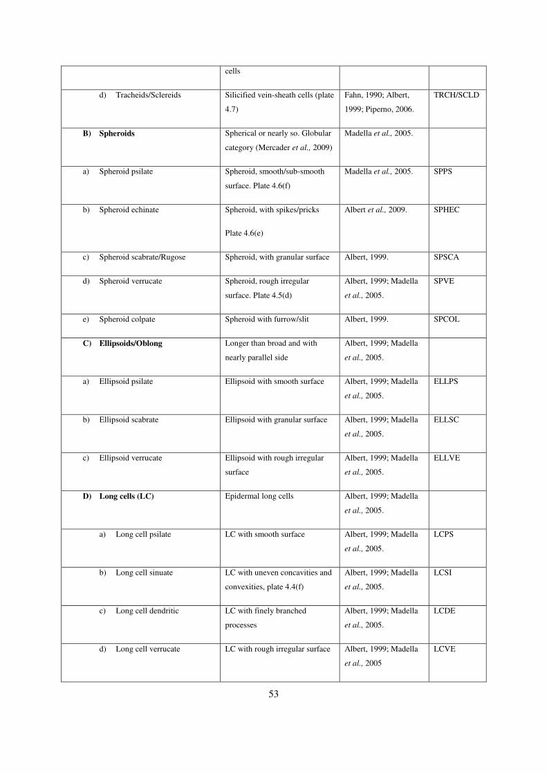
53
cells
d) Tracheids/Sclereids Silicified vein-sheath cells (plate
4.7)
Fahn, 1990; Albert,
1999; Piperno, 2006.
TRCH/SCLD
B) Spheroids Spherical or nearly so. Globular
category (Mercader et al., 2009)
Madella et al., 2005.
a) Spheroid psilate Spheroid, smooth/sub-smooth
surface. Plate 4.6(f)
Madella et al., 2005. SPPS
b) Spheroid echinate Spheroid, with spikes/pricks
Plate 4.6(e)
Albert et al., 2009. SPHEC
c) Spheroid scabrate/Rugose Spheroid, with granular surface Albert, 1999. SPSCA
d) Spheroid verrucate Spheroid, rough irregular
surface. Plate 4.5(d)
Albert, 1999; Madella
et al., 2005.
SPVE
e) Spheroid colpate Spheroid with furrow/slit Albert, 1999. SPCOL
C) Ellipsoids/Oblong Longer than broad and with
nearly parallel side
Albert, 1999; Madella
et al., 2005.
a) Ellipsoid psilate Ellipsoid with smooth surface Albert, 1999; Madella
et al., 2005.
ELLPS
b) Ellipsoid scabrate Ellipsoid with granular surface Albert, 1999; Madella
et al., 2005.
ELLSC
c) Ellipsoid verrucate Ellipsoid with rough irregular
surface
Albert, 1999; Madella
et al., 2005.
ELLVE
D) Long cells (LC) Epidermal long cells Albert, 1999; Madella
et al., 2005.
a) Long cell psilate LC with smooth surface Albert, 1999; Madella
et al., 2005.
LCPS
b) Long cell sinuate LC with uneven concavities and
convexities, plate 4.4(f)
Albert, 1999; Madella
et al., 2005.
LCSI
c) Long cell dendritic LC with finely branched
processes
Albert, 1999; Madella
et al., 2005.
LCDE
d) Long cell verrucate LC with rough irregular surface Albert, 1999; Madella
et al., 2005
LCVE

54
e) Long cell echinate LC with spiked surfaces Albert, 1999; Madella
et al., 2005.
LCECH
E) Parallelepiped (P) Tabular body with opposite
sides parallel to each other
Madella et al., 2005.
a) Parallepiped thin crenate With psilate texture and
scalloped edges
Albert, 1999; Madella
et al., 2005; Mercader
et al., 2010.
PPTCR
b) Parallepiped verrucate With rough irregular surface Albert, 1999; Madella
et al., 2005; Mercader
et al., 2010.
PPVE
c) Parallepiped dendritic With finely branched processes Albert, 1999; Madella
et al., 2005; Mercader
et al., 2010.
PPDT
d) Parallepiped thin psilate With smooth surface,
width<length
Albert, 1999; Madella
et al., 2005; Mercader
et al., 2010.
PPTP
e) Parallepiped blocky psilate With smooth surface, width
>length
Albert, 1999; Madella
et al., 2005; Mercader
et al., 2010
PPBP
f) Parallelepiped blocky scabrate With granular surface,
width>length
Albert, 1999; Madella
et al., 2005; Mercader
et al., 2010.
PPBS
g) Parallepiped facetate With scalloped edges Albert, 1999; Mercader
et al., 2010.
PPFC
F) Epidermal cells (EC) Silicified epidermal cells in-situ Albert, 1999; Mercader
et al., 2009.
a) Epidermal crenate EC with psilate texture and
scalloped edges
Albert, 1999; Mercader
et al., 2009.
EPC
b) Epidermal Jig-saw Thin epidermal cells with
puzzle-like out-line
Bozarth 1992; Albert,
1999; Mercader et al.,
2009.
EPJG
c) Epidermal polygonal Thin epidermal polygonal cells Albert, 1999; Mercader
et al., 2009.
EPPO
G) Honeycomb Assemblages Net-like-connected cells in situ Bozarth 1992; Albert, HYAS

55
Plate 4.6(d) 1999; Madella et al.,
2005.
a) Honeycomb elongates Network of elongates cells Albert, 1999; Madella
et al., 2005.
HYE
b) Honeycomb spheroids Network of circular/semi-
circular cells
Albert, 1999; Madella
et al., 2005.
HYSP
H) Silica skeletons (SC) Silicified sections of epidermal
cells
Bozarth, 1992; Rosen
1992; Albert, 1999.
a) Silica skeleton elongate cells SC with length>width. Plate
4.5(e)
Bozarth, 1992; Rosen
1992; Albert, 1999.
SSCEC
b) Silica skeleton spheroid cells SC cells circular Bozarth, 1992; Rosen
1992; Albert, 1999.
SSPEC
c) Silica skeletons
cylindroids/sinuous
SC elongate & circular cross
section
Bozarth, 1992; Rosen
1992; Albert, 1999;
Madella et al., 2005.
SSCCS
I) Irregular forms Silica bodies with no defined
shape/don’t belong to any of the
above category
Albert, 1999; Madella
et al., 2005.
IRRF
a) Irregular verrucate Irregular forms with rough
surfaces
Albert, 1999; Madella
et al., 2005.
IRRVE
b) Irregular scabrate Irregular forms with granulate
surface
Albert, 1999; Madella
et al., 2005.
IRRSC
c) Irregular psilate Irregular forms with smooth
surface. Plate 4.5(a)
Albert, 1999; Madella
et al., 2005.
IRRPS
3. Cyperaceae phytoliths
a) Papillae Hat-shaped silica bodies in
sedges. Plate 4.6(a-b)
Ollendorf, 1992;
Piperno, 2006
PAPL
b) Achene Cone shaped silica bodies in
sedges. Plate 4.6(c)
Ollendorf, 1992;
Piperno, 2006
ACHN

56
Plate 4.1- a) Bilobate panicoid type, b-c) bilobates convex outer margin short shaft, d-e quadralobate, f) tower horned

57
Plate 4.2-a-c) bilobate convex outer margin long shaft, d) bilobate concave outer margin short shaft, e) saddle type, f) saddle squat.

58
Plate 4.3-a) saddle ovate, b-c) tower wide, d) saddle plateau; e) epidermal crenate & saddle long at top-right.

59
Plate 4.4- a-b) tower wide, c) trapezoid polylobates, d) trapezoid e) saddles in situ; f) long cell sinuate & bilobates convex outer margin long shaft.

60
Plate 4.5-a) Irregular psilate; b) parallelepiped blocky psilate; c) long cells sinuate; d) spheroid verrucate; e) silica skeletons elongate cells.

61
Plate 4.6- a-b) Cyperus-silicified papillae; c) Cyperus-Achene type; d) Honeycomb assemblage; e) spheroid echinate; f) spheroid psilate.

62
Plate 4.7 a-c) Schlereids; d-e) tracheids

63
4.4 Data analyses
Phytolith were grouped into 59 morphotype categories, tallied for each plant specimen and the dataset
entered into an Excel spread sheet as raw data. The dataset was then normalized where all the types
which were below 2% of the total morphotypes tallied for each single plant were excluded. Using PC-
ORDTM software package, two forms of statistical procedures were conducted for morphotypes
derived from the modern reference collection (Peck, 2009). Simple statistical analyses such as bar
graphs were ran in excel to determine the general production pattern of grass short-cell phytoliths
among the four major grass sub-families in this study, namely C3 Arundinoideae, C4 Panicoideae, C4
Chloridoideae and C4 Aristidoideae.
4.4.1 Correspondence analysis/Reciprocal averaging.
Correspondence analysis [CA; reciprocal averaging (Hill, 1973)] is a multivariate ordination
technique used to identify similarities influencing groupings of elements/data within a specifically
constructed dataset. Principal Component Analysis (PCA) identifies maximum variance between
datasets (Greenacre, 1984).
In this study, correspondence analysis was carried out to evaluate the relationships between grass
phytoliths and known physio-geographical distributions (in this case, altitudinal distribution; Table
4.2), ecological habitats and the photosynthetic pathways of the Poaceae sub-families (Barboni and
Bremond, 2009). Additionally, to evaluate the potential of phytoliths derived from mixed vegetation
types, correspondence analysis was used on a dataset consisting of morphotypes tallied from all of the
plants analysed.
Different plant communities were classified on ordination space along the axes such that plants that
produced similar phytoliths composition were clustered close to each other, hence the analysis
distinguished phytolith morphotypes into vegetation components that require similar environmental
conditions, and especially moisture content which is relevant to palaeoenvironmental reconstruction
as discussed in the preceding chapters.
Further correspondence analyses helped to establish how well phytolith associations could estimate
the vegetation types and, though indirectly, infer possible environmental/climatic factors influencing
the distribution of morphotypes in a scatter plot. In the data matrix, plant specimens were treated as
samples (rows) with morphotypes as taxa (columns) before running correspondence analysis. The
statistical codes for both plants and the morphotypes categories are defined in table 4.3 of this chapter.

64
4.4.2 Cluster analysis
Cluster analysis is a statistical technique that groups data that are similar (but not identical) into one
cluster and those that are dissimilar into a different cluster (Hill, 1973). In order to identify principal
identifier-morphotypes, either singly or in associations, the raw data (modern reference) was run
through cluster analysis, with grasses as a separate dataset and then for all the plant species combined.
4.4.3 Tilia diagrams
For the fossil phytolith assemblages, the identified morphotypes were counted and the data presented
as A TILIA diagram composed of the assemblages from each level within the geological
profile/section, plotted against depth and the available age estimates.
The diagram consists of two parts: horizontal axis with various morphotypes and their frequencies
while the vertical axis shows depth and age. The change in percentages and composition of types
through time is assumed to be associated with changes in vegetation composition. These changes are
distinguished statistically using a constrained incremental sum-of-squares cluster analysis (CONISS)
which is a graphical component of the TILIA and TILIA GRAPH software (Grimm, 2007).
4.4.4 Grass short-cell phytolith indices
In order to understand vegetation cover changes in the Olorgesailie Basin, an additional proxy was
computed from the morphotype categories derived from grasses. The proportion of a grass subfamily
in the fossil assemblages was analysed by computing the proportion morphotypes derived from C3
grasses versus C4 grasses, in order to understand the associated environmental factors controlling
vegetation changes. Grass short-cell phytoliths identified from three major grass sub-families were
used in the analyses; C3 Pooideae, C4 Panicoideae and C4 Chloridoideae (Bremond et al., 2008).
Analysing selected grass short-cell phytoliths formed in grass leaf epidermal cells can be used to
distinguish C3 and C4 photosynthetic pathways (Twiss, 1992), therefore distinguishing major grass
sub-families (Twiss et al., 1969; Mulholland, 1989). C3 grasses occur in high latitudes and high
altitudes in the tropics under cool climates; trapeziform polylobate are the most typical in the
subfamily. C4 (Chloridoideae) grasses occur in arid and semi-arid regions under hot and dry climates;
saddles are the most typical morphotype in this sub-family. C4/C3 (Panicoideae) grasses contain both
photosynthetic pathways favoured by warm temperatures and moist climate; bilobates and
quadralobates are the most characteristic of Panicoideae grasses (Metcalfe, 1960; Twiss et al., 1969;
Tieszen et al., 1979; Piperno and Pearsall, 1998; Rossouw, 2009).
The selected grass short-cells phytoliths used in this analyses included the following for each grass
sub-family; Arundinoideae C3 grasses (rondel, saddle ovate), Panicoideae (bilobate panicoid type,

65
bilobate concave outer margin short shaft, bilobate convex outer margin short shaft, polylobates,
quadralobate/crosses, saddle long and tower horned); Chloridoideae (saddle, tower flat, bilobate outer
margin flattened long and Short shaft) and Aristidoideae (bilobate convex outer margin long shaft).
Additional grass sub-family was identified in the fossil assemblage: C3 Pooideae grasses (trapeziform
polylobates).
The key identifiers for the woody and herbaceous taxa in this study include; spheroid echinate (unique
identifier of Palmae family) (Albert et al, 2005; 2009), spheroid scabrate, sclereids, spheroid verrucate
and other irregular forms (representing the woody and herbaceous taxa) (Albert et al., 2005) and
achene (unique identifier of the Cyperaceae family) (Ollendorf, 1992).
Although individual phytolith types extracted from soils/sediments are not traceable to individual
grass taxa, the relative ratio of morphotypes unique to C3 and C4 sub-families may be traced to grass
sub-family and hence serve as climatic indices for interpreting paleoclimate of a region (Twiss, 1992).
Two indices; climate index (IC) and aridity index (Iph) (Bremond et al., 2008) were calculated using
grass short-cell phytoliths exclusively derived from grasses, with the aim of determining the
dominance of C3 relative to C4 grasses in the fossil assemblage in order to understand grassland
dynamics in the Olorgesailie Basin and the surrounding environs, as well as determine estimates of
climatic changes.
4.4.4.1 Climate index (IC)
This index refers to the total of selected grass short-cell phytoliths derived from the Pooideae grasses
(trapeziform polylobates) divided by the sum of selected grass short-cell phytolith types produced by
Pooideae, Chloridoideae (saddles,) and Panicoideae (Polylobates, crosses and bilobates outer margin
convex short shaft) grasses (Bremond et al., 2008; Barboni and Bremond, 2009).
IC= Pooideae morphotypes/ (Pooideae + Panicoideae +Chloridoideae) morphotypes
High IC ( 0.5) reflects grasslands dominated by Pooideae C3 grasses while low IC ( 0.4) reflects
grasslands dominated by Panicoideae and Chloridoideae C4 grasses. In Africa, IC increases with
elevation, hence decreasing temperatures (Bremond et al., 2008). Low IC indicates grasslands
dominated by C4 grasses, suggesting warm climates.
4.4.4.2 Aridity index (Iph)
This index refers to the ratio of total Chloridoideae (saddles) vs. the sum of C4 grasses (both
Chloridoideae and Panicoideae (bilobates concave/convex outer margin short shaft, crosses, and
polylobates) grass short-cell phytoliths. This is a useful indicator of the dominance of short C4 grasses

66
over tall C4 grasses which reflects trends in aridity –humidity at low elevations (Bremond et al.,
2005b; 2008).
Iph= (Chloridoideae Phytoliths)/ (Chloridoideae + Panicoideae) Phytolith types
High Iph indices, close to 1, indicate arid conditions while a low index close to zero indicate a humid
climate (Bremond et al., 2008).
4.4.5 Dicotyledon versus Poaceae index (D/Po)
This index is the ratio of diagnostic phytolith morphologies with taxonomic significance of tropical
woody plants versus grass short cell phytoliths diagnostic to grass subfamilies (Bremond et al., 2008).
Phytolith morphologies considered to calculate D/Po include; all spheroid variants except for spheroid
psilate for woody plants, while for Poaceae all diagnostic grass short cells phytoliths were considered.
D/Po= (Spheroid echinate + spheroid scabrate + spheroid verrucate)/ (saddle variants + rondels +
bilobates variants + Quadralobates/crosses + tower variants).
High D/Po indices, close to 1, indicate close-canopy vegetation dominated with woody plants/trees
while low indices will indicate open-canopy vegetation dominated with grasslands (Bremond et al.,
2009).
4.5 Summary
This chapter presented detailed information on the materials and methods used to collect statistically
viable data for both the modern phytolith analogue and the fossil assemblages analysed in this
research. Field methodologies and laboratory techniques were presented. Due to the magnitude of the
data, it was divided into two datasets i.e. the modern analogue and the fossil phytolith data. Results of
the modern analogue dataset are presented in the following chapter.

67
CHAPTER FIVE: RESULTS OF THE
MODERN ANALOGUE REFERENCE
5.1 INTRODUCTION
This chapter presents results of modern phytolith data obtained from sixty-nine plant species
representing 17 families, which were processed and analysed in order to provide a modern phytolith
analogue, for comparison with interpretation of fossil phytolith data from the Olorgesailie Basin
(chapter 6 of this study). Of the seventeen families, Poaceae and Cyperaceae family yielded distinct
morphotypes. The Poaceae produced short-cell phytoliths, Cyperaceae produced achene and papillae
morphotypes while woody and herbaceous taxa yielded mostly variable categories which included
irregular variants, spheroid variants and tracheids/schlereids types. In-situ silicified cells were
observed and classified in most of the studied specimens which dominated in woody and herbaceous
taxa. Appendix I shows the data sheet of the percentage occurrence of various phytolith morphotypes
identified in modern plant specimens.
5.2 Differential phytolith production among grass sub-families
Results from analysing the percentage abundance of grass short phytolith among four major
subfamilies shows that it is possible to identify major grass subfamilies through the analysis of the
abundance of various morphotypes, as well as the presence and/or absence of certain types (Fig 5.1).
In this study, Arundinoideae grasses produced predominantly 61% of saddle ovate (SADO), 13% of
both saddle long (SADL) and tower flat (TWF) while other morphotypes are rare (<3%) and saddles
(SAD) are completely absent.
Panicoideae grasses produce abundant bilobates types accounting for 53% of the total phytolith count,
with bilobates concave outer margin short shaft (BCOMSS) leading with 23%. Other abundant
morphotypes in this group include tower horned (TWHN) with 12%, quadralobate (QCR) with 6%
and polylobates (PLY) with 5%. Types that are rare to absent include saddle plateau (SADP), saddle
squat (SADS) and saddle ovate (SADO).
Chloridoideae grasses produced predominantly saddles (SAD) 31%, 12% tower flat (TWF), 10%
tower horned (TWHN) and 9% bilobates types except for the bilobates concave outer margin long
shaft (BCOMLS), which were absent. Other saddle variants account for 8%.

68
Aristidoideae grasses produced predominantly bilobates convex outer margin long shaft (BCXMLS)
58%, 19% saddle plateau (SADP) and 12% tabular crenate (TBCR). Other morphotypes were rare
accounting for <3%.
Chloridoideae rondels could not be distinguished from those produced by C3 grasses because tower
flat (TWF) were equally present in both subfamilies, accounting for 12% and 13% respectively.
Figure 5.1 Graph showing the relative dominance of major grass morphotypes in four grass-sub-
families. See appendix II for the complete names of the morphotypes.
5.3 Relationship between phytolith morphotypes to vegetation types
Sixty-nine different plant species belonging to 17 families were processed and analysed for modern
reference. Of the seventeen families, Poaceae and Cyperaceae yielded the most abundant distinct
phytolith types. It was possible to identify types found in-situ with their parent cells; however, most
morphotypes were disintegrated from the parent cell and were identified as described in Madella et
al., (2005). The herbaceous and woody taxa produced mainly the irregular forms, occasionally
producing spheroids and ellipsoids. Verrucate variants were the most dominant within these two taxa.
The cylindroids and parallelepiped types were also present. Analysis of non-grass morphotypes was
highly significant in characterising vegetation types. Ellipsoid verrucates (ELLVE) notably occurred
in abundance in Ficus natalensis for instance.
5.3.1 Correspondence Analysis between morphotypes and plant species
Correspondence analysis is a descriptive/exploratory statistical technique used to visualize the
association between two-way tables with some measure of correspondence between rows and

69
columns presented graphically in ordination space (Greenacre, 1984). In this study, correspondence
analysis (CA) was applied to investigate associations of various morphotype categories to the parent
plant species from which they were extracted and to determine whether the distribution of various
morphotypes on the scatter plot could be related to the possible underlying environmental factors. CA
therefore was used to identify underlying similarities within the modern analogue morphotypes
dataset by classifying plant species into different vegetation categories along the axes according to
possible taxonomic, climatic and ecological significance (Tieszen et al., 1979; Barboni et al., 2007;
Barboni and Bremond, 2009; Rossouw, 2009; Mercader et al., 2010; 2011).
In this analysis, plant species were categorised as samples (rows) while morphotypes were categorised
as species (columns).
CYPAP
CYPsp1
CYPsp2
CYPsp3
SCLbov
CYPsp4
ELOCsp
CYPsp5
ARISTjunARISTsp1
ERAGRrac
SPOROafr
SPOROcon
CHLORvir
CYNODsp
ERAGRsp
ERAGRsp1
CHLORsp
ERAGRsp2
ERAGsp3
ERAGsp4
BEW Sbi
DACTYsp
HYPARsp
SCHZjeff
MELamb
UNKW N
MELspp
COELsp
PENNpur
PENNpolMELrepTHEMDsp
PENNpol
BRACHNsp
HYPARsp1
SCHIZspp
THEMDsp1
ANDRsp
DIGsp
POA1
POA2
POA3
POA4
POA5
POA6
POA7
POA8
PHRAGmau
PHRAGaus
BARsp
ACANemn
RHUnat
VERbra
CAPPspINDGsp
CROTsp
ABTsp
FICnat
TARRgr
RUBsp
GREW fa
BCOMLS
BCOMSS
BCXMLS
BCXMSSBFOMLS
BFOMSS
BN
BNFMLS
BNFMSS
PB
BLL
CN
CV
CPB
CP
CSC
PLPS
PLSC
TRCD
SCLD
SSSL
SSCP
SSSEC
EPCR
EPJG
HYAS
SPVE
SPPS
SPHSC
ELLVE
EESC
ELLPS
DICSC
LCPS
LCVE
PAPL
HB
HR
STHR
PLY
QCR
ROND
SAD
SADL
SADP
SADO
SADS
TWF
TWHNTWW
EPROND
SCPR
PPEI
PBPSQ
PTP
PPCR
IRRVE
IRRFOR
INDT
0
0
20 40 60 80 100
10
20
30
40
50
60
70
80
Axis 1
Axis
2
I
II
III
Figure 5.2 shows a scatter plot obtained from correspondence analysis of 59 different phytolith
morphotypes (blue squares) identified from 69 plant species (red circles); Poaceae and non-Poaceae
families.
The results of correspondence analysis show the first axis (eigenvalue 0.778) explained 27.4% of the
total variance, while the second axis (eigenvalue 0.741) explained 9% of the total variance/inertia
(10.25). This analysis was run using both PCORD and CANOCO software. The two major axes

70
explain the correlation between plant species and major morphotype categories occurring in
abundance in the plant species. Furthermore, from the scatter plot indirect inference of the underlying
environmental conditions can be deduced, particularly in terms of moisture conditions versus
vegetation categories.
Plant species occurring under similar environmental conditions (as summarised in table 4.1) are
closely distributed in the ordination space making it possible to identify three vegetation components
(Fig 5.2). I) Aquatic vegetation (identified by Axis-1) comprising of Cyperaceae (Cyperus sp. 3,
Cyperus sp. 4, Cyperus papyrus and Eleocharis sp.). This component is strongly distinguished by
Papillae (PAPL) phytolith morphotype, identified only from these species and absent from other plant
species analysed. Surprisingly, three species of the genus Cyperus do not seem to be strongly
associated with the papillae morphotype. The axis distinguishes Cyperaceae (negatively) from other
herbaceous and woody taxa (positively). II) Woody taxa (Tarrena graveolens, Croton sp. Grewia
fallax. Indigofera sp. Capparaceae sp. and Rubiaceae sp. and the herbaceous component, including
Acanthaceae eminence, Vernonia brachiates and Barleria sp. The distribution of the woody taxa is
largely distinguished by the following morphotypes: schlereids (SCLD), tracheids (TRCD), spheroid
verrucate (SPVE), silica skeletons senso lato (SSSL) and ellipsoid psilate (ELLPS) while the
herbaceous taxa are characterised by irregular forms (IRRF) and long cell psilate (LCPS). III) The
Poaceae family (both C3 and C4 grasses) which is largely distinguished by the presence of grass short-
cell phytoliths and is comprised of Chloridoideae, Panicoideae, Aristidoideae and Arundinoideae sub-
families. Axis 2 distinguishes herbaceous and woody taxa negatively from grasses and sedges. This
could suggest woody and non-grass herbaceous taxa are generalists in relation to moisture content and
therefore do not show much correlation with the axis which is interpreted in this case to indicate
increasing moisture content on the x-axis (fig 5.2).
5.3.2 Correspondence analysis between grass species and corresponding
morphotypes
Correspondence analysis of 27 morphotype categories derived from 42 grass species evaluated the
relationship between short grass phytoliths and grass subfamilies. This approach determined the
potential of phytoliths to distinguish between C3 and C4 grass-sub-tribes, for the purpose of
determining the relationship between grass phytoliths and the underlying environmental/ climatic
factors. Grass species belonged to four main grass sub-families which are important in the area of
study namely, Panicoideae C4 (25 species), Chloridoideae C4 (11 species), Aristidoideae C4 (2
species), Arundinoideae C3 (2 species) and unidentified (12 species).

71
Results of the correspondence analysis (fig 5.3) show that the first axis (eigenvalue 0.762) explained
18.3% of the total variance and the second axis (eigenvalue 0.662) explained 15.4% of the total
variance (5.39).
ARISTjunARISTsp1
ERAGRrac
SPOROafr
SPOROcon
CHLORvir
CYNODsp
ERAGRspERAGRsp1
CHLORsp
ERAGRsp2
ERAGsp3
ERAGsp4
BEW Sbi
DACTYspHYPARsp
SCHZjeff
MELamb
UNKW N
MELspp
COELsp
PENNpur
PENNpol
MELrep
THEMDsp
PENNpol
BRACHNsp
HYPARsp1
SCHIZspp
THEMDsp1
ANDRsp
DIGsp
POA1
POA2
POA3POA4
POA5
POA6
POA7
POA8
PHRAGmau
PHRAGaus
BCOMLS
BCOMSS
BCXMLS
BCXMSS
BFOMLS
BFOMSS
BN
BNFMLS
BNFMSS
BLL
CN
CV
EPCR
SPPS
STHR
PLY
QCR
ROND
SAD
SADL
SADP
SADO
SADS
TWF
TWHN
SCPR
TBCR
0
0
10 20 30 40 50 60 70 80
20
40
60
80
100
Axis 1
Axis
2
I
II
III
Figure 5.3 shows the scatter plot ordination obtained from correspondence analysis between grass
species (red circles) and corresponding grass short-cell phytoliths (blue squares).
Three main principal groups are observed from the scatter plot (fig 5.3). I) Chloridoideae C4
subfamily are short grasses associated with hot and dry climates and are mainly found in low altitudes
in the tropics (Tieszen et al., 1969; Twiss, 1992; Rossouw, 2009). They included Cynodon sp.,
Eragrostis sp., Eragrostis racemosa, Andropogon sp. and Chloris virgata. This group is largely
influenced by the dominance of saddle (SAD) and saddle squat (SADS) morphotypes. II) Panicoideae
C4 sub-family are tall grasses associated with warm and moist climates and are distributed across a
range of altitudes up to 3050 metres (Tieszen et al., 1969; Twiss, 1992). They included Pennisetum
polystachion, Melinis repens, Melinis ambigua, Themeda sp., Schizachyrium jeffreysii and other
unidentified grasses. This group is largely influenced by the presence of quadralobate/crosses (QCR),

72
polylobates (PLY) and bilobates morphotypes, except for the bilobate outer margin convex long shaft
types (BCXMLS); and III) Arundinoideae C3 grasses which are associated with moist environments
and are mainly distributed in both high and low altitudes in wet environments including swamps and
along riverbanks. This includes Phragmites australis and P. mauritianus. It is worth noting that the
Aristidoideae C4 grasses appear to be negatively influenced by the same factors influencing the
distribution of the Arundinoideae C3 grasses on the scatter plot. They included Aristida juncformis
and A. congesta (Aristidoideae grasses). Morphotypes that correspond with the Arundinoideae grasses
included saddle ovate (SADO), tower flat (TWF) and saddle long (SADL) morphotypes while
Aristidoideae corresponds with saddle plateau (SADP) and bilobates outer margin convex long shaft
types (BCXMLS).
Axis 1 distinguishes Arundinoideae C3 grasses on its positive end from C4 grasses on the negative
end, indirectly reflecting increasing moisture along the x-axis while axis 2 distinguishes Panicoideae
from Chloridoideae grasses. This trend shows increased aridity along the x-axis. Notably,
Aristidoideae grasses appear on the same quadrant with Panicoideae grasses though on the extreme
end of the scatter plot. Since their ecological habitats are mainly very dry and disturbed grounds
(Ibrahim and Kabuye, 1987), their distribution on the scatter plot is not just influenced by moisture.
5.3.3 Phytolith morphotype-plant associations
Two datasets were run through cluster analysis: first, morphotypes derived from all the species
analysed and second, morphotypes derived from only the Poaceae family. Morphotypes with
increased distance measures showed the highest dissimilarities from other morphotypes in terms of
their occurrence among the plants analysed.
These outliers are discussed as the most likely unique identifier of the associated/parent plant species
(see fig. 5.4): papillae (PAPL) derived from Cyperaceae, saddle (SAD) derived from Chloridoideae C3
grasses, tower horned (TWHN) and bilobate outer margin concave short shaft (BCOMSS), derived
from Panicoideae C4 grasses and saddle ovate (SADO) identified mostly from Arundinoideae C3
grasses. A major cluster stands out comprising of bilobates outer margin concave long shaft
(BCOMLS), bilobates outer margin convex short shaft (BCXSS), polylobates (PLY) and tower flat
(TWF), all produced by the Panicoideae C4 sub-family. Cluster analysis showed that taxonomic
affiliation of phytolith morphotypes can be strongly observed for the Poaceae family but not for the
woody and herbaceous taxa. Morphotypes appearing in the middle of the dendrogram are referred to
as generalists.

73
Distance (Objective Function)
Information Remaining (%)
7.3E+00
100
4.7E+04
75
9.4E+04
50
1.4E+05
25
1.9E+05
0
BCOMLSBCXMSSPLYSTHRSCPRTWFBFOMLSSSSECELLVEHBLCPSPTPCSCSPVECPBTWWEPJGPBEESCHRHYASLCVETRCDSCLDELLPSPBPSQPLPSDICSCRONDEPRONDBFOMSSPPEICVSSSLSSCPIRRVESADSSPHSCFBLBNQCRBNFMLSBNFMSSEPCRTBCRSADLCNSADPPLSCIRRFORINDTSPPSBLLCPSADOBCXMLSTWHNBCOMSSSADPAPL
Figure. 5.4 Cluster analysis dendrogram, wards linkage method and distance measure; Euclidean
Pythagorean, among phytolith morphotypes from all species combined.
To further investigate the taxonomic affiliation of major grass short-cell phytoliths for grasslands
classification, cluster analysis was run for 27 morphotypes derived from grasses alone (fig 5.5).
Distance (Objective Function)
Information Remaining (%)
9.8E+01
100
2.9E+04
75
5.8E+04
50
8.6E+04
25
1.1E+05
0
BCOMLSBCXMSSBFOMLSRONDCVBFOMSSBLLBNPLYQCREPCRBNFMLSBNFMSSSPPSSADSTBCRSADLCNSADPSTHRSCPRSADOTWFBCXMLSTWHNBCOMSSSAD
Figure 5.5 Cluster analysis dendrogram showing 27 grass morphotypes derived from 42 grass
species.
The cluster analysis (fig 5.5) plots the following morphotype categories distinctively from the rest:
saddle (SAD) bilobates concave outer margin short shaft (BCOMSS), tower horned (TWHN),
bilobate convex outer margin long shaft (BCXMLS) and saddle ovate (SADO) which have been
earlier identified as dominant in; Chloridoideae, Panicoideae, Aristidoideae and Arundinoideae grass

74
sub-families respectively. Other morphotypes are treated as generalist in this case and they can only
suggest the presence of grasslands in a given assemblage, rather than any specific grassland type.
5.3.4 Significance of results
Correspondence analyses demonstrated the potential of using phytolith morphotypes to classify
vegetation types that require similar environmental conditions, therefore indirectly suggesting the
most probable environmental and/or climatic conditions associated with fossil phytolith assemblages
in palaeoecological research. Vegetation types grasslands, woody and herbaceous vegetation and
wetlands. Outlier morphotypes identified by cluster analysis showed the most dissimilarity, and hence
are the unique-identifiers for their corresponding parent plants. They included papillae (PAPL),
Saddle type (SAD), bilobates concave outer margin short shaft (BCOMSS), bilobate convex outer
margin long shaft (BCXMLS) and Saddle ovate (SADO).
5.4 Summary
This chapter has presented the results of the modern phytolith data analysed from sixty-nine
individual plants. The morphotypes that show a significant association (either taxonomically or
ecologically) with their parent plant are used in the analyses of fossil assemblage in the following
chapter.
75
CHAPTER SIX: RESULTS OF THE
FOSSIL PHYTOLITH ASSEMBLAGES
6.1 INTRODUCTION
This chapter presents the vegetation history through 662 ka, how it changed both temporally and
spatially, as well as the associated prevailing climatic conditions, as deduced from fossil phytolith
assemblages from geological sections in localities B, G and Oltepesi. The sediments were obtained
from the Olorgesailie Formation (992-493 ka), Olkesiteti Formation (~340-166 ka) and Oltepesi Beds
(~105-67 ka). The data presented here are derived from palaeosol layers in which absolute dates are
not available, but relative ages are provided from various geological markers dated using 40Ar/39Ar
technique unless otherwise stated (Deino and Potts, 1990). Therefore, the chronology is presented in
terms of different geological phases during the early-middle-late Pleistocene (~340-64 ka) based on
single crystal 40Ar/39Ar (Deino and Potts, 1990; 1992).
Phytoliths analysed from the Olorgesailie sediments achieved statistically sufficient quantities
required to give valuable information on the fossil plant assemblages that constituted the past
vegetation cover during the Pleistocene period. Notably, several grass short-cell phytoliths were
identified in the fossil assemblage which were absent in the modern analogue assemblages presented
in Chapter 5. This is significant because it enabled climatic indices to be calculated (see appendix II).
On one hand, some morphotypes identified in the modern analogue were rare to absent in the fossil
assemblage, probably due to poor preservation caused by silica dissolution (Piperno, 2006) e.g.
papillae types (PAPL). Unless otherwise stated the definition and interpretation of the fossil
assemblage is based on categories discussed in Chapter 5.
Two approaches were used to achieve the palaeocological research objectives. First, changes in
vegetation were reconstructed on a temporal scale spanning the mid-late Pleistocene (~760-64 ka).
Second, the spatial heterogeneity in vegetation in the Olorgesailie Basin was determined across the
palaeolandscape during the period between ~340-220 ka. In addition, grass phytolith indices are
analysed and presented in this chapter as estimates of the climatic conditions that prevailed during the
mid-late Pleistocene in the Olorgesailie Basin and their surrounding environments. Tree cover density
is determined by calculating the ratio of dicotyledon morphotypes versus grass short cell phytoliths
derived from the sediments.
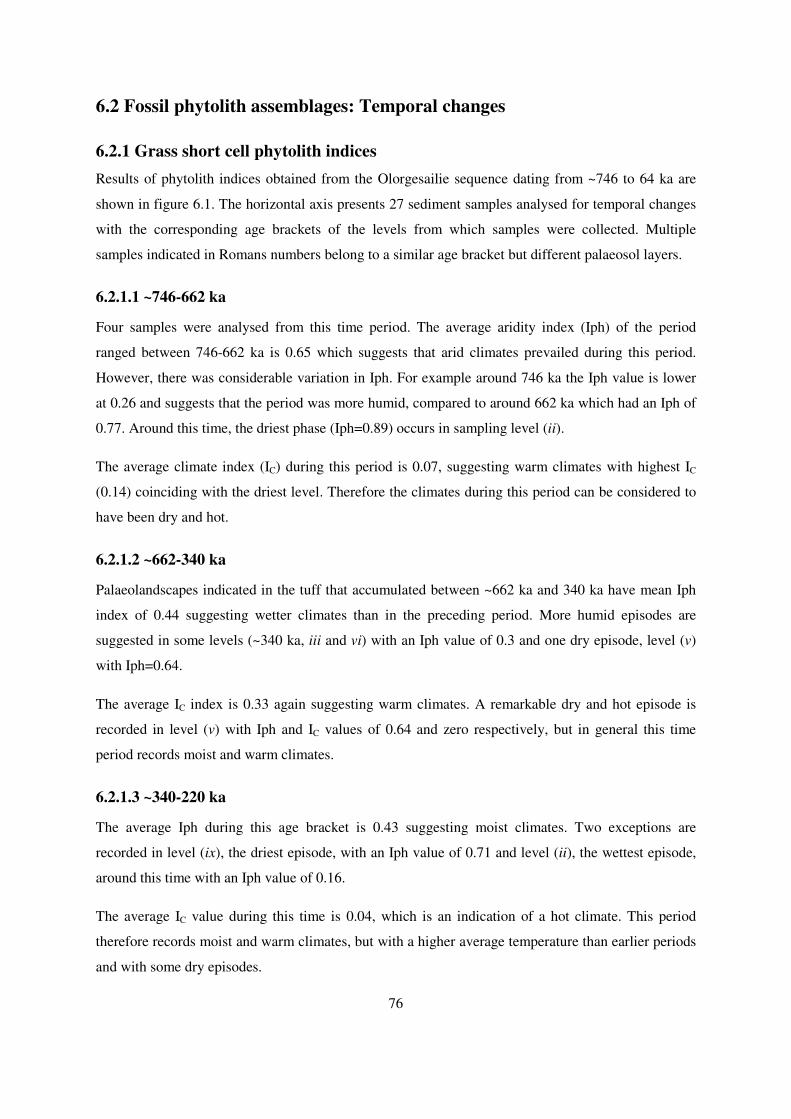
76
6.2 Fossil phytolith assemblages: Temporal changes
6.2.1 Grass short cell phytolith indices
Results of phytolith indices obtained from the Olorgesailie sequence dating from ~746 to 64 ka are
shown in figure 6.1. The horizontal axis presents 27 sediment samples analysed for temporal changes
with the corresponding age brackets of the levels from which samples were collected. Multiple
samples indicated in Romans numbers belong to a similar age bracket but different palaeosol layers.
6.2.1.1 ~746-662 ka
Four samples were analysed from this time period. The average aridity index (Iph) of the period
ranged between 746-662 ka is 0.65 which suggests that arid climates prevailed during this period.
However, there was considerable variation in Iph. For example around 746 ka the Iph value is lower
at 0.26 and suggests that the period was more humid, compared to around 662 ka which had an Iph of
0.77. Around this time, the driest phase (Iph=0.89) occurs in sampling level (ii).
The average climate index (IC) during this period is 0.07, suggesting warm climates with highest IC
(0.14) coinciding with the driest level. Therefore the climates during this period can be considered to
have been dry and hot.
6.2.1.2 ~662-340 ka
Palaeolandscapes indicated in the tuff that accumulated between ~662 ka and 340 ka have mean Iph
index of 0.44 suggesting wetter climates than in the preceding period. More humid episodes are
suggested in some levels (~340 ka, iii and vi) with an Iph value of 0.3 and one dry episode, level (v)
with Iph=0.64.
The average IC index is 0.33 again suggesting warm climates. A remarkable dry and hot episode is
recorded in level (v) with Iph and IC values of 0.64 and zero respectively, but in general this time
period records moist and warm climates.
6.2.1.3 ~340-220 ka
The average Iph during this age bracket is 0.43 suggesting moist climates. Two exceptions are
recorded in level (ix), the driest episode, with an Iph value of 0.71 and level (ii), the wettest episode,
around this time with an Iph value of 0.16.
The average IC value during this time is 0.04, which is an indication of a hot climate. This period
therefore records moist and warm climates, but with a higher average temperature than earlier periods
and with some dry episodes.

77
6.2.1.4 ~220-64 ka
Six samples were analysed from this time bracket. The average Iph value for this period is 0.39,
suggesting moist climates, while the average IC value is 0.02 which is an indication of hot climates.
The highest Iph value is 0.55 in level (iii), suggesting a period of mild aridity. The climates during
this period are therefore generally moist and warm.
Figure 6.1 Graph showing trend of grass phytolith indices over period between ~746 to~64 ka.
6.2.2 Dicotyledon versus Poaceae morphotypes index (D/Po)
Results obtained from calculating the ratio of phytolith morphotypes characteristic of dicotyledon
plants and the Poaceae family derived from Olorgesailie sequence (~746-64 ka) are shown in fig. 6.2
below.
Figure 6.2 Graph showing trend of dicot/ Poaceae index over a period between~746 to ~64 ka
The figure shows that D/Po index was high during the period bracket ~662-340 ka, with the highest
index of 0.55 recorded in the sample dating more than 340 ka (fig. 6.2). Low indices are recorded in

78
the sequence after ~340 ka, with the lowest index (0.4) occurring in the sediments younger than 340
ka.
6.3 Reconstructing vegetation history
Phytolith assemblages identified from a vertical profile matched chronologically from four geological
sections and correlated to the modern phytolith analogue, give an account of the vegetation changes of
the Olorgesailie Basin during the Pleistocene. In addition, the data are described concurrently with
climate indices computed earlier in the chapter. Data are presented as phytolith diagrams produced by
the TILIA and TILIA GRAPH programs 1.01 (Grimm, 2007); zones were identified using a
constrained incremental sum-of-squares cluster analysis (CONISS) which is a component integral to
the TILIA software (Grimm, 2007).
6.3.1 Phytolith spectra during the Pleistocene period (~746-64 ka)
Phytolith spectra and indices produced by the Tilia program indicate that vegetation cover was
dominated by grasslands during the Pleistocene period. The following is a description of the phytolith
diagram (Olorg) in terms of temporal changes in vegetation composition.
Three major phytolith zones were identified within the sequence and are greatly influenced by
variation in Poaceae composition and distribution throughout the profile (Fig 6.3). These zones
tentatively correspond to different stages of the Pleistocene period.
6.3.1.1 Olorg. I (level 150-115) (~746 -662 ka)
This zone represents deposits bracketed by volcanic tuff ~746 ka in M-9 of the Olorgesailie formation
and M-10 tuff ~ 662 ka. The zone is characterised by the presence of phytolith morphotypes of the
grass short-cell phytoliths contributed mainly by three grass sub-families (Arundinoideae, Panicoideae
and Chloridoideae), and the variable phytolith categories derived from non-Poaceae taxa; hence two
major taxa are represented: Poaceae, woody and herbaceous taxa including sedges (Fig 6.2). The zone
comprises two sub-zones distinguished by the relative proportions of the following phytolith
categories: Rondels (ROND), saddle long (SADL), bilobates convex outer margin short shaft
(BCXMSS), spheroid echinate (SPHEC), spheroid psilate (SPPS), irregular verrucate (IRRVE) and
irregular forms (IRRF). These combinations of morphotypes represent Arundinoideae C3 grasses
(wetlands grasses), Panicoideae C4 grass (typical of warm and moist conditions), palm (moist
conditions) and other woody & herbaceous taxa. Phytolith categories derived from Chloridoideae and
Aristidoideae C4 grasses are rare to absent in this zone accounting for <5%. The composition and
proportion of the above morphotypes in this zone indicate mixed vegetation: woody grasslands
dominated by moisture indicators such as Arundinoideae C3 and Panicoideae C4 grasses suggesting

79
wetter climates. C3 Pooideae grasses remain at low percentages throughout the zone suggesting warm
temperatures. There is a notable decrease of C4 Chloridoideae and Aristidoideae grasses from sub-
zone Ia to sub-zone Ib.
A) Sub-zone: Olorg Ia (level 150-140)
The sub--zone marks a slight decline in rondel morphotypes from ~15% to 10%, saddle long from 5%
to 2% while bilobates convex outer margin short shaft gradually increases from ~5% to 15%. The
sub-zone reflects grasslands comprised of C3 Arundinoideae and C4 Panicoideae grasses with some
herbaceous taxa present (spheroid echinate/palms, spheroid psilate and ellipsoid psilate).
B) Sub-zone: Olorg Ib (level 140-115)
The sub-zone is dominated by the rondel category ~20%, saddle long ~10% and palm-type ~10%, and
hence marks an expansion of C3 Arundinoideae grasslands while C4 grasses are rare to absent. Other
phytolith categories significant in this sub-zone include irregular forms, irregular verrucate and
achene (Cyperaceae), all suggesting vegetation cover consisting of grasslands with, woody and
herbaceous taxa. The sub-zone suggests mixed vegetation dominated by moisture indicator grasses
and with warm temperatures.
6.3.1.2 Olorg. II (level 115-50) (~662-220 ka)
This zone is dominated by phytolith categories derived from C3 grasslands and C4 Panicoideae
grasses. They include; rondel, saddle long and bilobates convex outer margin short shaft- all which
are ≥10%. Also present are bilobates flattened outer margin short shaft, scutiform/prickles and
spheroid psilate ~10%. Two sub-zones are influenced by relative dominance of grass short-cell
phytoliths as follows:-
A) Sub-zone: Olorg. IIa (levels115-90) (~662-340 ka)
The sub-zone is dominated by grass short-cell phytoliths indicative of C3 Arundinoideae and C4
Panicoideae grasses. Rondel morphotype increases from <5% (level 115) to 20% (level 100) before
declining to 5% (level 90). Saddle long increases from 5% (level 115) to 15% (level 105; 90). These
morphotypes are strong indicators of Arundinoideae grasses suggesting an expansion of C3 grasslands.
Also on the rise are bilobates convex outer margin short shaft derived from C4 Panicoideae grasses as
well as scutiform/prickle for undifferentiated grasses. Other morphotypes prominent in this sub-zone
include, bilobates convex outer margin long shaft (Aristidoideae type) (~10%) and bilobates flattened
outer margin short shaft (Chloridoideae grasses) (~10%). This sub-zone suggests that vegetation was
dominated by moisture indicator grasslands growing under warm climates.

80
B) Sub-zone: Olorg. IIb (levels 90-50) (~340-220 ka)
This sub-zone is dominated by morphotypes all derived from grass sub-families; rondels (15%),
bilobate convex outer margin short shaft (10%), scutiforms/prickles (15%) saddles (10%) and
spheroid psilate (10%). Other significant morphotypes (~5%) include C3 Pooideae grasses (trapezoid
polylobates) palms (spheroid echinate) and Cyperaceae (achene) which influences zonation in this
level. The climate seems relatively drier than sub-zone IIb.
6.3.1.3 Olorg. III (levels 50-10) (~220-64 ka)
The level marks two sub-zones characterised by the abundance of phytoliths in the samples. Some
samples did not yield a statistically significance phytolith count while others yielded high phytolith
counts, hence the occurrence of two sub-zones. The sub-zones are distinguished (Olorg IIIa &b) at
level 25, where palm morphotypes peaks at ~10% and the rondel category increases from 5% to 15%
while other grass morphotypes decrease, suggesting a wet episode at the boundary between the two
sub-zones. In the sub-zone Olorg IIIb, only one sampling level (10) records substantial phytolith
counts and shows a trend in the expansion of C4 grasses.

81
1015
20
2530
35
4045
5055
60
6570
7580
85
9095
100105
110
115120
125130
135
140145
150
Samplin
g level
s
662 ka
746 ka
340 ka
220 ka
64 ka
Rel
ative
Dates
(40A
r/39Ar)
Trapez
oid p
olylo
bate
20
RondelTabula
r cre
nate
Tower
wid
e
20
Saddle
long
Saddle
ova
te
Bilo
bate
panic
oid ty
pe
20
Bilo
bate
convex
outer m
argin
short
shaft
Tower
horn
ed
Quad
ralo
bate c
rosse
s
Bilo
bate
concave
oute
r mar
gin s
hort s
haft
Saddle
Saddle
squat
Bilo
bate
flare
d, short
shaf
t
Bilo
bate
flatte
ned oute
r mar
gin s
hort sh
aft
Bilo
bate
flatte
ned oute
r mar
gin lo
ng shaft
Bilo
bate
convex
outer m
argin
long s
haft
Saddle
pla
teau
Bilo
bate
notched/fl
ared o
uter m
argin
short
shaf
t
20Scu
tiform
/pric
kles
Bulli
form
Spheroid
ech
inate
/palm
type
20
Spheroid
psila
te
Trachei
ds/ S
chlere
ids
Spheroid
Scab
rate
Ellipso
id P
sila
te
20
Irreg
ular v
errucat
e
20
Irreg
ular f
orms
Cyl
indro
id s
cabra
te
Paral
lele
piped e
longat
e thin
sca
brate
Ach
eneIn
deter
min
able
sPhyto
lith z
one
Olorg IIIb
Olorg IIIa
Olorg IIb
Olorg IIa
Olorg Ib
Olorg Ia
Woody & herbaceous taxaUndiff. grasses
Chloridoideae/AristidoideaePanicoideaePooideae
Arundinoideae
0.20.40.60.81.01.21.41.61.82.02.22.42.62.8
Total sum of squares
CONISS
Figure 6.3 Phytolith diagram for Olorgesailie Basin. The abundance of each morphotype is expressed as a percentage of the assemblage sum.

82
6.4 Spatial changes during mid-Pleistocene (~220-340 ka)
As mentioned above, the Olorgesailie Basin has been subjected to a variety of geological processes
resulting in a variety of palaeolandscapes. In some areas, active erosion occurs while simultaneously
in other areas channel filling can take place (Behrensmeyer et al., 2002). These processes may have
affected the corresponding land cover, creating patches of micro-habitats across the landscape as
observed in the current vegetation distribution. Such microhabitats include the occurrence of riverine
vegetation along the river channels and marshy habitats on the flood plains dominated by
Arundinoideae C3 grasses, palms and sedges.
The fossil phytolith assemblages derived from three geological sections, each representing Localities
B, G and Oltepesi are considered for spatial analysis. These sections are correlated with two dated
geological markers: green pumice tuff at ~225 ka and 340 ka tuff. Section G08/01 is separated from
section B05/04 by the Mt. Olorgesailie outcrop and whose main sources of deposits are the main Ol
Keju Nyiro river channel in the east, and the Ol Keju Nyiro tributaries in the west. Further west is the
flood plain of the Ol Keju Nyiro river where Oltepesi deposits form (refer to the map in chapter 4, fig.
4.3).
The three localities have been subjected to different synergies controlled by the Ol Keju Nyiro river
channel systems. Localities B and G represent the high energy phase of the river systems and are
separated by Mt. Olorgesailie, while the Oltepesi plain represents a lower energy phase. Depending on
the exposed palaeosol layer in each locality, 5, 6 & 12 samples were analysed from G, B and Oltepesi,
respectively.
Comparison of the phytolith assemblages through the sedimentation sequence of the three trenches is
hereby presented.
6.4.1 Phytolith diagram for B05/04 (~340-220 ka)
The phytolith sequence from six samples is presented in the form of a TILIA diagram; phytolith
morphotypes are classified into their respective vegetation components for clear discussion. Two
zones are distinguished by CONISS, corresponding to variations in the major morphotypes derived
from Poaceae and non-Poaceae groups selected on the basis of their dominance within the samples
analysed (fig 6.4):
6.4.1.1 B05-04 I
This zone is characterised by the dominance of morphotypes derived from woody and herbaceous
taxa comprising irregular verrucate (25%), ellipsoid psilate (25%), irregular forms (18%), spheroid

83
scabrate (10%) and spheroid echinate (palm type) (10%) while grass phytoliths were notably rare to
absent except for undifferentiated grass phytoliths; scutiform/prickles category. This suggests a more
densely wooded landscape. Two sub-zones are identified by CONISS:-
A) B05-04 Ia
The sub-zone is represented by palaeosol close to 340 ka tuff, where grass short-cell phytoliths are
rare with <5% while three morphotypes from woody and herbaceous taxa are present with higher
proportions ranging from 10% to 18%. Palm phytoliths are absent in this sub-zone. Towards the sub-
zone boundary, grass short-cell phytolith morphotypes increase from 5% to 15% while those from
woody and herbaceous taxa are absent. Thus the zone suggests an initially woody phase but with the
landscape becoming more open and grass-dominated.
B) B05-04 Ib
Samples in this sub-zone consist of morphotypes derived from woody and herbaceous taxa, ranging
between 10% and 25% which is higher than the other samples. Grass short-cell morphotypes are rare
to absent in this sub-zone with rondels (5%) and saddle long (10%) mainly derived from C3
Arundinoideae grasses.
6.4.1.2 B05-04 II.
The zone is dominated by morphotypes derived from woody and herbaceous taxa ranging between
10% and 20%. Grass short-cell phytoliths present in this zone rondel category (15%) and
scutiform/prickles (15%).
Phytolith assemblages from this section indicate vegetation cover around locality B was dominated by
woody & herbaceous taxa. The occurrence of palm phytoliths in all samples except for one sample
(level 60, fig 6.4) indicates wetland ecosystems/marshy environments (Albert et al., 2009; Barboni et
al., 2010). There is a notable absence of grass short-cell phytoliths derived from C4 Chloridoideae and
Aristidoideae grasses in this section which is probably an indication of moist environments and a
more wooded landscape.

84
10
15
20
25
30
35
40
45
50
55
60
Sam
ples
~220 ka
~340 ka
Rel
ativ
e Dat
es (4
0Ar/
39A
r)
20
RondelSad
dle lo
ng
Bilo
bate
conve
x oute
r marg
in s
hort s
haft
Bilo
bate
flatte
ned o
uter
mar
gin s
hort s
haft
20
Scutifo
rm/p
rickle
s
Spheroid
ech
inat
e/palm
s
20
Spheroid
psi
late
Spheroid
Sca
brate
20
Ellipso
id P
sila
te
20
Irreg
ular
verr
ucate
20
Irreg
ular
form
s
Phy
tolit
h zo
ne
B05-04 II
B05-04 Ib
B05-04 Ia
Woody & herbaceous taxaPoaceae C3/C4
0.2 0.4 0.6 0.8 1.0
Total sum of squares
CONISS
Figure 6.4 Phytolith spectra for Locality B.

85
6.4.2 Phytolith diagram for OLT05/02 (~340-220 ka)
The TILIA diagram (fig. 6.5) presents the results of 12 samples collected from all the palaeosols in
Oltepesi locality. This sequence yielded more samples than expected since there were more palaeosol
layers than in the other geological sections. From this sequence, 33 morphotypes were identified and
classified into their respective vegetation components. Three major zones are distinguished as
follows:
6.4.2.1 OLT05/02 I
The zone is characterised by occurrence of the morphotypes derived from both Poaceae and non-
Poaceae taxa which include: rondels (10-15%), saddle long (5-10%), saddles (5-10%) and scutiform
/prickles (5-15%). However, there is a slight dominance of grass short-cell phytoliths over woody and
herbaceous taxa. Two sub-zones are classified through CONISS analysis as follows:
A) OLT05/02 Ia
Three samples presented in this sub-zone show a higher occurrence of grass short-cell phytoliths (fig
6.4): rondels (10%), saddle long (15%), bilobates convex outer margin short shaft (18%) as indicators
of Arundinoideae C3 grasses and Panicoideae C4 grasses which later decline. Other significant
morphotypes in this sub-zone included bilobates convex outer margin short shaft (Panicoideae),
saddles and bilobates flattened outer margin short shaft (Chloridoideae) and bilobates convex outer
margin long shaft (Aristidoideae) grasses.
B) OlT05/02 Ib
The sub-zone is characterised by rondel (20%), bilobates convex outer margin short shaft (20%) and
scutiform/prickles (20%). Morphotypes derived from C4 Chloridoideae & Aristidoideae are rare to
absent in the sub-zone.
6.4.2.2 OLT05/02 II
The zone is characterised by an abundance of short grass cell phytoliths but with a notable decline in
the rondel category (<5%); bilobate concave outer margin short shaft (15%), and C4 saddle category
slightly declining from 10% to 5%. The dominance of the following grass short-cell phytolith
(bilobates panicoid type, bilobates outer margin concave short shaft and saddle long) indicate
dominance in Panicoideae C4 grasses in this zone, i.e. an open landscape lacking woody elements.
6.4.2.3 OLT05/02 III
This zone comprises phytolith assemblages from three samples. Significant morphotypes include
rondels (20%), bilobates convex outer margin short shaft (10-20%), bilobates flattened outer margin
short shaft (10-20%) derived from both C3 and C4 grass subfamilies; spheroid echinate/palm

86
morphotype (10%). Other morphotypes present include spheroids and ellipsoids variants derived from
woody and herbaceous taxa and achene type from Cyperaceae.
The OLT05/02 sequence results suggest vegetation cover was characterised by sparsely wooded
grasslands comprising both C3 and C4 moisture indicator grass species. The general inference is that
vegetation cover between ~340-220 ka was dominated by wetland grasslands (Arundinoideae and
Panicoideae grasses).The presence of spheroid echinate (palm) and achene morphotypes further
indicates the occurrence of wetlands.

87
10
15
20
25
30
35
40
45
50
55
60
65
70
75
80
85
90
95
100
105
110
115
120
Sampl
es
~220 ka
~340 ka
Rel
ativ
e da
tes
(40A
r/39A
r)
Trape
zoid
pol
ylob
ate
20
Rond
elTow
er w
ide
Saddl
e lo
ng
Saddl
e ov
ate
Bilo
bate
panic
oid ty
pe
20
Bilo
bate
conv
ex o
uter m
argin
sho
rt s
haft
Tower
hor
ned
Qua
dralo
bate
cro
sses
Bilo
bate
conc
ave
outer
mar
gin s
hort
sha
ft
Saddl
e pl
atea
u
Bilo
bate
conv
ex o
uter m
argin
long s
haft
20
Saddl
eSad
dle
squat
Tower
flat
Bilo
bate
flare
d, s
hort s
haft
Bilo
bate
flatte
ned o
uter
mar
gin lo
ng s
haft
20B
ilobat
e fla
ttene
d oute
r m
argin
sho
rt s
haft
Bilo
bate
notch
ed/fl
ared
oute
r m
argin
shor
t shaf
t
20
Scutif
orm/p
rickl
es
Bulli
form
Bilo
bates
indet
er
Trach
eids
/scl
erei
ds
Sphero
id e
chin
ate
20
Sphero
id p
sila
te
Sphero
id S
cabr
ate
Ellipso
id s
cabr
ate
Ellipso
id P
sila
te
Cyl
indro
id C
rena
te
Cyl
indro
id s
cabr
ate
Irreg
ular
form
s
Paral
lele
piped
elo
ngate
thin
sca
brate
Ach
ene
Indet
erm
inab
les
Phyt
olith z
one
OLT05/02 Ia
OLT05/02 Ib
OLT05/02 II
OLT05/02 III
Woody & herbaceous taxaUndiff. grasses
Chloridoideae/AristidoideaePanicoideaePooideae
Arundinoideae
0.2 0.4 0.6 0.8 1.0 1.2
Total sum of squares
CONISS
Figure 6.5 Phytolith spectra for Oltepesi plains

88
6.4.3 Phytolith diagram for G08/01 (~340-220 ka)
Phytolith assemblages from five samples suggest stable vegetation. Since the samples did not vary
much in terms of morphotypes composition, no definite zones were classified by CONNISS (fig. 6.6).
Only 12 morphotypes achieved 2% of the total assemblages: grass short-cell phytoliths were the main
component. The phytolith sequence did not show significant temporal variation during the period
~340-220 ka except for level 50 where woody and herbaceous taxa dominate. The rest of the sequence
is dominated by grass short-cell phytoliths representing both C3 and C4 taxa. Although very few
morphotypes were considered in this sequence, it appears that the vegetation cover indicated was open
mixed grasslands with both C3 and C4 components.
10
15
20
25
30
35
40
45
50
sam
ples
~220 ka
~340 ka
Rela
tive
date
s (4
0Ar/3
9Ar)
Trap
ezoid
poly
lobate
20
Ronde
l
Tower
wid
e
Saddle lo
ng
Tower
horn
ed
Bilo
bate
conve
x oute
r marg
in s
hort s
haft
Bilo
bate
flatte
ned o
uter m
argin
sho
rt s
haft
Saddle
Bilo
bate
conve
x ou
ter m
argin
long s
haft
Scutiform
/pric
kles
Sphero
id S
cabra
te
Spheroid
psi
late
Woody & herbaceous taxaPoaceae C3/C4
0.00.00.10.10.10.10.10.20.20.20.20.20.30.3
Total sum of squares
CONISS
Figure 6.6 Phytolith spectra for Locality G.
6.5 Summary
This chapter has presented results of phytolith analysis of the fossil assemblages. Both temporal and
spatial vegetation cover changes provide significant results that are interpreted and discussed within
the context of the mid-late Pleistocene period in the following chapter. Their significance to hominin
behaviour that interacted with these environments in the Olorgesailie Basin is also discussed in the
following chapter.

89
CHAPTER SEVEN: INTERPRETATION
and DISCUSSION
7.1 INTRODUCTION
In this chapter, the results of phytolith data from both modern reference and fossil assemblages are
interpreted and discussed within the context of the Olorgesailie Basin as an important prehistoric site.
The significance of the results within the context of wider palaeocological studies is also discussed.
Phytolith analysis from three localities within the Olorgesailie Basin, in the southern part of the Rift
Valley in Kenya has proved to be of importance in reconstructing past vegetation changes, and as an
indirect proxy in determining the prevailing climatic conditions through the mid-late Pleistocene
(~740~60 ka). This is particularly useful in view of the basin’s archaeological and paleontological
richness, along with the absence of other organic plant fossils (such as pollen) that could yield insights
into the possible vegetation structure during the emergence and the persistence of the genus Homo.
The modern reference phytoliths from present-day vegetation along an altitudinal gradient played a
crucial role in identifying the possible vegetation cover of the palaeo-landscapes of the Olorgesailie
Basin. Multivariate analysis of the selected modern plants’ phytoliths showed a correlation between
phytolith morphotypes and contemporary vegetation types. Correlating the modern phytolith
analogues with known temperature and rainfall gradients associated with different plant assemblages,
enabled inferences to be made of the past climate-vegetation relationships as reflected by fossil
phytolith assemblages (Bremond et al., 2005a; 2005b).
Phytolith indices of climate (mainly temperature) and aridity, computed from selected grass short
phytoliths (Bremond et al., 2008) suggested the presence of warm and moist climates in the
Olorgesailie Basin and the surrounding environments during the mid-late Pleistocene. Analysis of
fossil phytolith assemblages through time suggest mainly open vegetation cover, dominated by
moisture-indicating C3 Arundinoideae and C4 Panicoideae grasses during the mid-late Pleistocene
(~740-64 ka). However, the presence of woody and non-Poaceae herbaceous elements suggest that
sparsely wooded thickets also existed in these landscapes particularly during the mid-Pleistocene
(746-662 ka) when the climate was more humid (Trauth et al., 2007).
The current study provides evidence of spatial variation in the vegetation across the landscape during
the period ~340-220 ka. Phytolith assemblages from different localities but particularly locality B
suggest the existence of micro-habitats most commonly associated with riverine vegetation. Locality
G and Oltepesi sequences on the other hand suggest vegetation dominated by grasslands.

90
The existence of patchy wooded habitats across the landscapes is also indicated in the fossil
assemblages. This included the presence of palms which are significant indicators of wetlands or
localities with a high water table (Albert et al., 2009). The presence of sedges in the Olorgesailie
Basin further suggests marshy environments were present in these palaeolandscapes. This, however,
contrasts with the current vegetation cover which is dominated by Chloridoideae (C4) short grasses
more commonly associated with semi-arid climates. Cyperaceae are still present along the water
bodies but no palms are seen within the vicinity of the basin.
The interpretation of the fossil assemblage results is based on the assumption that the Palaeosols are
chronologically placed and bracketed by the geological markers dated from the Olorgesailie Basin by
Deino and Potts, (1990) and the geological work currently in progress (unpublished ages by Deino et
al., 2010).
7.2 Modern phytolith analogue
Phytoliths derived from different plants were classified into different categories (Appendix I). Woody
and herbaceous taxa produced the most variable categories which included spheroid variants, ellipsoid
variants, tracheids, schlereids and silicified appendages. Individual woody and non-grass herbaceous
plants showed insignificant association with particular morphotypes, but as a vegetation component,
significant correlation with their morphotypes is generally deduced (Piperno, 2006). Morphotypes
derived from grasses and sedges showed significant correlation both taxonomic and ecological, with
grass short-cell phytoliths having the strongest correlation (Twiss, 1992; Barboni and Bremond, 2009;
Rossouw, 2009). Thus grass short-cell phytoliths played a crucial role to achieve the main goal of this
study.
Efforts made to describe various morphotypes, for instance saddle (SAD), saddle ovate (SADO),
saddle squat (SADS) and saddle long (SADL), further influenced the ordination of different grass
species (fig 5.3). Three grass sub-families were distinguished: Arundinoideae, Aristidoideae and
Chloridoideae, depending on which saddle type dominated.
The variants described in the saddle category for this study accords with other descriptions published
in the literature (Twiss et al., 1969; Thorn, 2004; Barboni et al., 2007; Barboni and Bremond, 2009;
Rossouw, 2009; Mercader et al., 2010; 2011). Saddle ovate (SADO) as “rondel with round base
(Piperno and Pearsall, 1998)” and saddle long (SADL) occurred more abundantly in Arundinoideae
grasses than in other taxa; saddle (SAD and saddle squat (SADS) predominated in Chloridoideae
grasses while saddle plateau (SADP) was more common in Aristidoideae than in other taxa (Piperno
and Pearsall, 1998; Piperno, 2006).
91
Results further showed that Chloridoideae grasses exhibited strong redundancy compared to other
grass sub-families as they produce most of the grass phytolith categories described in this study
although in varied quantities. However, the description of the tower category (Mercader et al., 2010),
(referred to as rondel in most publications) (Twiss et al., 1969; Madella et al., 2005; Barboni et al.,
2007; Barboni and Bremond, 2009) into three tower morphotypes was one way of dealing with the
challenges of redundancy and multiplicity (Rovner, 1983) which has been critical in interpreting grass
short-cell phytoliths (Piperno and Pearsall, 1998; Barboni and Bremond, 2009). For instance, tower
flat (TWF) was more dominant in Chloridoideae, tower horned (TWHN) dominated in Panicoideae
while tower wide (TWW) was insignificantly low in both sub-families. The tower category was rare
to absent in the Arundinoideae grasses and is therefore, a type that can be considered in future to
distinguish the rondels occurring in Arundinoideae, Pooideae and Chloridoideae grasses.
Description of the bilobates category to further discriminate between different grass sub-families was
successful. Although a high percentage (48%) of the bilobates were recorded in Panicoideae grasses,
the bilobates convex outer margin long shaft (BCXMLS) category was abundant (58%) in the
Aristidoideae grasses while absent in other subfamilies, hence distinguishing the Aristidoideae grasses
from other subfamilies. This bilobates category is easily separated from those in the Panicoideae
grasses (Piperno, 2006: Fahmy, 2008; Rossouw, 2009). Furthermore, bilobates outer margin flattened
both short and long shafts categories was common in Chloridoideae grasses, though their collective
percentage occurrence was insignificantly low ~9% and therefore their potential significance requires
further research.
Two Arundinoideae grasses were processed and analysed for this study. Saddle ovate (SADO) was
dominant (61%) in both suggesting that this category could be used as an indicator of the presence or
absence of Arundinoideae grasses in fossil phytolith assemblages.
For the mixed vegetation dataset, correspondence analysis can indirectly give estimates of the
vegetation types represented by phytolith assemblages, as well as an indication of the underlying
environmental and/or climatic factors, which are of great interest for palaeoecological research.
7.2.1 Phytoliths and the altitudinal distribution of plant species
Phytoliths derived from plants collected from three different ecological zones; Mount Kenya
(montane forest), Taita hills (dry forest) and the Olorgesailie Basin (savanna grasslands) showed no
significant trend with altitudinal change, but were instead significantly related to moisture content.
Similar results from Miombo (Brachystegia) woodland in Mozambique (Mercader et al., 2011)
showed no distinction between phytoliths collected from cool highland Miombo woodland with those
from Miombo woodlands from the dry lowlands. However, this seems to contradict previous studies

92
from Mount Kenya in East Africa (Tieszen et al., 1979) and other phytolith-based climate
reconstruction studies (Twiss, 1992; Fredlund and Tieszen, 1994). This contrast can be explained by
the fact that such studies (Tieszen et al., 1979; Twiss, 1992; Fredlund and Tieszen, 1994: Barboni and
Bremond, 2009) only analysed grass short-cell phytoliths, and the distribution of grasses is strongly
correlated with temperature and moisture gradients, and thus altitudinal gradient (Ibrahim and
Kabuye, 1987; Livingstone and Clayton, 1979; Tieszen et al., 1979; Barboni and Bremond, 2009;
Rossouw, 2009). The current study shows the analyses of modern plants and all of their corresponding
morphotypes indeed has potential significance in a palaeoecological context. Such a focus helps to
identify vegetation structure associated with different habitats such as grasslands, woody and
herbaceous and aquatic habitats, which is crucial for the reconstruction of palaeoenvironments in East
Africa (Alexandre et al., 1997; Barboni et al., 1999; Albert et al., 2006; 2009; Ashley et al., 2010).
7.2.2 Multivariate analyses
Woody and herbaceous taxa produced mainly the variable phytolith morphotypes (Bozarth, 1993;
Albert, 1999; Albert et al., 2000; Bremond et al., 2005a, Mercader et al., 2009) which included
spheroid variants (SPH-) ellipsoids (ELL-), irregular (IRR-), schlereids (SCLD) and tracheid (TRCH).
These morphotypes are key indicators of woody and non-grass herbaceous elements in a fossil
assemblage. Hence they are of great potential in palaeoecological reconstruction to distinguish past
vegetation canopies and structure, specifically the presence of woody elements/patches in the
landscape (Mercader et al., 2000; Albert et al., 2006; Barmford et al., 2006; Ashley et al., 2010a).
The achene (ACHN) and papillae (PAPL) morphotypes identifies the Cyperaceae family (Ollendorf,
1992) and hence indicates wetland and marshy environments (Ashley et al., 2010a; 2010b).
The description of grass short-cell phytoliths (Mercader et al., 2010) further beyond the International
Code for Phytolith Nomenclature 1.0 (ICPN, Madella et al., 2005) and the regional classification
scheme (Twiss et al., 1969), strengthened the morphological association of various morphotypes to
their respective sub-families as discussed below-
a) Bilobates
These morphotypes distinguished two grass subfamilies discussed in this study; Panicoideae and
Aristidoideae. Panicoideae grasses contributed largely bilobates concave/convex outer margin short
shaft (BCOMSS/BCXMSS) (Twiss et al., 1969; Mulholland, 1989; Madella et al., 2005) while
Aristidoideae grasses produced bilobates convex outer margin long shaft (BCXMLS) (Piperno, 2006;
Rossouw, 2009). Fossil assemblages dominated by BCOMSS/BCXMSS suggest moist grasslands
under warm climates while one dominated by BCXMLS suggests short grasslands under arid climates
and/or disturbed grounds (Tieszen et al., 1979; Ibrahim and Kabuye, 1987; Barboni and Bremond,
2009).

93
b) Saddles
Two saddle categories distinguished Chloridoideae and Arundinoideae grasses. Saddle-shaped (Twiss
et al., 1969; Madella et al., 2005; Rossouw, 2009) distinguished Chloridoideae while saddle ovate
(SADO) distinguished Arundinoideae grasses. A phytolith assemblage dominated by SAD indicates
arid- and semi- arid grasslands while SADO suggests wetlands/ marshy environments (Rossouw,
2009).
c) Towers
This category was initially classified as rondel category (Fredlund and Tieszen, 1994; Wallis, 2000)
but was described further with the aim of reducing the multiplicity and redundancy aspect of this
category (Mercader et al., 2010). Tower horned (TWHN) dominated in the Panicoideae grasses, tower
flat (TWF) in the Chloridoideae, and tower wide (TWW) in Arundinoideae grasses. Their variations
within fossil assemblages can be discussed accordingly, hence distinguishing grassland components
more accurately. This is a challenge that the rondel category has exhibited in other phytolith studies
(e.g. Piperno and Pearsall 1998; Kondo et al., 1994).
d) Rondels
These morphotypes refer to entirely circular and oval shaped phytoliths (Twiss et al., 1969; Piperno
and Pearsall, 1998; Barboni and Bremond, 2009). In this study they are predominantly produced by
the Arundinoideae grasses. Hence, a high occurrence in the fossil assemblage suggests a dominance
of Arundinoideae grasses associated with moist climates (see Ollendorf et al., 1988).
e) Other grass morphotypes
These are grass generalist morphotypes that occurred in all the grasses analysed. They included
bulliforms and scutiform/prickles which collectively identified the undifferentiated grasses. Their
dominance in an assemblage allowed the differentiation between different vegetation types. For
example, their abundance would indicate grass-dominated vegetation with a more open canopy
compared to an assemblage dominated by variable morphotypes. Abundance of the latter in an
assemblage would be associated with vegetation dominated by woody and herbaceous taxa and hence
a more closed canopy, such as riverine vegetation and/or wooded savanna depending on the presence
and dominance of other grass sub-families in the assemblage.
7.2.2.1 Phytolith production among grass sub-families
Phytolith production among grasses is variable. The relative abundance of short grass phytoliths (fig
5.1) showed Panicoideae grasses can be distinguished by a higher abundance of bilobates (BCOMSS/
BCXMSS) and TWHN while Arundinoideae grasses are characterized by a higher abundance of
SADO and TWW. Chloridoideae grasses on the other hand are associated with a higher abundance of

94
SAD and TWF while Aristidoideae grasses by higher abundance in BCXMLS (refer to appendix II for
morphotype names). The morphotypes were thus identified as key indicators of grass sub-families in
the fossil assemblages. The summary of these morphotypes is presented in appendix IV.
7.2.2.2 Correspondence analysis
Correspondence analysis (CA) grouped plant species on the basis of their phytolith compositions.
Three vegetation components were identified and classified in the ordination space according to the
affiliated environmental factors (fig 5.2). This indirectly identified moisture content as the major
environmental factor responsible for the distribution of modern plants and their corresponding
phytolith morphotypes.
The three vegetation components identified were grasslands, woody and herbaceous taxa and aquatic
taxa which can be differentiated by moisture availability. This trend is further suggested by results of
the correspondence analysis among grasses (fig 5.3); where Panicoideae (warm and humid) appear
separate from Chloridoideae and Aristidoideae (hot and dry). This is an indication of the influence of
moisture on the distribution of grasses and a result which is ecologically appropriate (Livingston and
Clayton, 1979; Tieszen et al., 1979; Twiss, 1992; Barboni and Bremond, 2009). This is important in
assessing the climatic conditions associated with fossil phytolith data (Alexandre et al., 1997;
Bamford et al., 2006, Piperno, 2006).
7.2.2.3 Cluster analysis
The unique phytolith morphotypes identified in this study were the major outliers in the cluster
analysis (Figs 5.4 and 5.5) namely: papillae (PAPL) in Cyperaceae, saddle (SAD) in Chloridoideae,
bilobate concave outer margin short shaft (BCOMSS) and tower horned (TWHN) in Panicoideae and,
saddle ovate (SADO) in Arundinoideae. A similar trend is observed in fig. 5.5: where the taxonomic
affiliation of grass short-cell phytoliths to the corresponding sub-family is meaningful. The results
match and corroborate earlier phytolith studies in Africa (Runge, 1995; Bremond et al., 2008; Barboni
et al., 2007; Barboni and Bremond, 2009; Rossouw, 2009; Mercader et al., 2010; 2011).
The analysis of grass short-cell phytoliths indicates evidence of multiplicity and redundancy i.e. the
occurrence of different morphotypes in one grass species and occurrence of certain morphotypes in
more than one grass tribe (Rovner, 1983; Piperno, 2006). This is a challenge faced by other phytolith
workers (e.g. Twiss et al., 1969; Rovner, 1983; Mulholland, 1989; Fredlund and Tieszen, 1994;
Piperno and Pearsall, 1998; Barboni and Bremond, 2009) as well as in the current study (see table
8.1). However, differential occurrences of various morphotypes in grasses contribute in identifying
grasslands dominated by different sub-families and which are associated with specific moisture and

95
temperature regimes (Tieszen et al., 1979; Fredlund and Tieszen, 1997; Barboni and Bremond, 2009;
Rossouw, 2009).
This study applied a region-based modern phytolith analogue as a proxy to meaningfully reconstruct
the vegetation cover of the Olorgesailie Basin both temporally and spatially, as well as in estimating
the associated climatic conditions during the mid-late Pleistocene (746-64 ka).
7.3 Fossil assemblages
Previous studies demonstrated the potential of phytolith analysis, not only as a palaeocological tool to
reconstruct vegetation history (Rovner, 1971; Piperno, 1988; 1989; Barboni et al., 1999; Ashley et al.,
2010) and grasslands dynamics (Alexandre et al., 1997; Rossouw, 2009), but also to determine
palaeoenvironmental climatic conditions associated with these changes (Bremond et al., 2005a:
2005b: Bremond et al., 2008; Barboni and Bremond, 2009; Rossouw, 2009). This is a key strength
evident in a range of studies which reconstruct palaeoenvironments of major prehistoric/hominin sites
in the East African region (Barboni et al., 1999; Albert et al., 2006; 2009; Barboni et al., 2010). Fossil
phytolith assemblages derived from selected palaeosols (see appendix III) were classified according to
vegetation types they represented in order to interpret vegetation changes and associated climates.
7.3.1 Temporal vegetation changes
The Olorgesailie phytolith sequence is characterised by an abundance of grass short-cell phytolith
categories, which are indicators of both C3 and C4 grasses. However, there is a notable rarity of
morphotypes derived from C4 short grasses (Chloridoideae and Aristidoideae) throughout the
sequence, which is a major component in the contemporary vegetation cover, suggesting that the mid-
late Pleistocene climates were wetter than present.
The presence of phytolith morphotypes derived from woody and herbaceous taxa (Olorg zone I; fig
6.3) is an indicator of mixed vegetation cover particularly during the mid-Pleistocene period (~746-
662 ka). However, the dominant vegetation cover was grassland (both C3 and C4 grasses), as reflected
by grass short-cell phytoliths >15% and non-Poaceae herbs while those indicating woody taxa,
including palm trees, remained rare throughout the sequence suggesting an open landscape with
scattered trees or patches of trees. This conclusion is based on the following selected morphotype
categories: rondel, saddle long, bilobates convex outer margin short shaft, scutiforms/prickles,
spheroid psilate, irregular verrucate and irregular forms (see fig 6.3).
Although achene morphotypes were not abundant, their presence in the sequence, particularly in
Olorg zones I&II, further indicates moist/aquatic environments during the mid Pleistocene period
particularly between ~746-662 ka. Such environments are suggested by the diatom flora indicating

96
shallow water environments around 493 ka (Owen et al., 2009) in the Olorgesailie Basin. This is
further corroborated by the fact that fresh water bodies or perhaps a high water table were present in
the basin, as evidenced by the occurrence of palms in the sequence (Albert et al., 2009).
Interestingly, the presence of Pooideae C3 grass phytoliths suggests cooler climates than present were
experienced in the basin during the Pleistocene period. However, the signature in the phytolith record
is insignificantly rare compared to other grasses, and hence cannot be relied on to interpret this as
indicating the glacial period that was experienced globally during the period (Mudelsee and
Stattegger, 1997).
Notable vegetation shifts from 340 ka suggest an episode of relatively wetter climate as evidenced by
the expansion of Arundinoideae and Panicoideae grasses on the landscape, while Chloridoideae
grasses declined significantly. These scenarios suggest that vegetation shifted from grasslands
dominated by C3 grasses to C4 Panicoideae. Such variability has been noted previously during the
Plio-Pleistocene (Sikes et al., 1994; Potts, 1998). Around ~100-64 ka, the expansion of
Arundinoideae C3 grasses occurred as well as an increase in the abundance of C4 Panicoideae grasses,
suggesting warm and moist conditions as indicated by aridity index of ~0.46 and climate index of
0.48. This period coincided with a phase of high lake levels in East and West African lakes around 70
ka and provides evidence of more humid conditions (Bergner and Trauth, 2004; Scholz et al., 2007;
Bergner et al., 2009).
Phytolith analysis therefore indicated that vegetation cover during the mid-late Pleistocene was
dominated by moist-loving grasslands with a sparse cover of woody elements.
7.3.2 Phytolith indices
In order to determine the climatic/ environmental conditions and vegetation structure of the
Olorgesailie Basin during the Plesitocene, results of three indices are discussed. These indices
include; climate index (IC), aridity index (Iph) and dicot/Poaceae index (D/Po) (Bremond et al., 2008).
7.3.2.1 Grass short-cell phytoliths versus climate and aridity indices.
Grass short-cell phytoliths are used to distinguish grasses beyond family level to their respective sub-
families (Metcalfe, 1960; Wallis, 2000), and to infer the associated climatic signals/ ecological
affiliation (Twiss, 1992; Fredlund and Tieszen, 1994; Barboni and Bremond, 2009; Rossouw, 2009)
in the fossil assemblages. Indices computed from selected grass short-cell phytoliths are examined
from the fossil assemblages; C3 Pooideae-trapeziform polylobate (cool climates) C4 Panicoideae –
bilobates and quadralobates (warm and moist) and C4 Chloridoideae grasses-saddles (warm and dry)

97
(Bremond et al., 2008) allowing estimates of paleoclimate in terms of temperature and moisture to be
discussed.
The current study shows that palaeoclimates in the Olorgesailie Basin were generally warm and
humid during the Pleistocene period corresponding with the general wet episodes suggested by high
lake levels in East Africa (Trauth et al., 2001; 2003; Bergner and Trauth, 2004), especially during the
late-Pleistocene (~139-133 ka). Previous studies suggest East Africa experienced regional climate
changes that were independent of the global glacial and interglacial cycles during the Pleistocene
(Marchant et al., 2006; Trauth et al., 2007). It is not surprising that the global glacial episode was not
recorded in this sequence, as local topography has a strong influence on precipitation in the region.
7.3.2.2 Dicotyledon versus Poaceae index (D/Po)
D/Po index suggest that the vegetation structure of the Olorgesailie Basin was dominated with open
grasslands during the Pleistocene period. However, the period between ~662-340 ka suggest
vegetation cover dominated with woody plants/trees, followed by expansion of open grasslands after
~220 ka to 64 ka (fig 6.2). This finding further explains the reason for early hominin settlement within
the Basin; the availability of forest resources.
7.3.3 Spatial vegetation changes
Phytolith data from three localities within the Olorgesailie Basin suggest a certain degree of
heterogeneity in vegetation cover across the palaeolandscape between ~340 ka to 220 ka. This is
indicated by the presence of mixed grasslands with varying tree cover although tree cover declined
significantly at one point. Locality B (B05/04) records a high dominance of morphotypes derived
from woody and herbaceous taxa ranging between 10%-25% while the highest occurrence of grass-
derived morphotypes is 15% (rondel category) (fig 6.5). Occurrence of palm phytolith (5%-10%) in
five out of six samples suggests marshy environments and/or freshwater sources (Albert et al., 2009;
Ashley et al., 2010; Barboni et al., 2010). The high occurrence of woody derived morphotypes
(irregular verrucate, spheroid scabrate), indicate wooded vegetation cover in Locality B during ~340
ka to 220 ka. Although grass phytoliths are not abundant in the sequence, the occurrence of grass
short-cell phytoliths indicative of Arundinoideae and Panicoideae grasses further suggest moist
environments in the locality.
Oltepesi plain (OLT05/02; fig 6.5) records the highest number of morphotypes compared with B05/04
and G08/01 (fig 6.4 & 6.6). However, only 10 morphotype categories were tentatively significant for
vegetation reconstruction since they recorded >10% occurrence of the total sum. Morphotypes derived
from grasses are more abundant than those derived from woody and herbaceous taxa, suggesting
vegetation cover dominated by grasses. However, there is little variation in the grass components, and

98
all the three subfamilies are represented throughout the sequence, suggesting the presence of mixed
grasslands, with both C3/C4 grasses. Other significant non-grass morphotypes in the sequence include
palm phytoliths and Cyperaceae (achene type) which suggest wet environments particularly around
~220 ka.
The Locality G sequence is dominated by grass short-cell phytoliths with the rondel category
recording a higher percentage (~15%) in four out of five samples. Only two morphotypes derived
from woody & herbaceous taxa are recorded in G08/01 sequence, which dominate in the oldest
sample (~340 ka of age; fig. 6.6). Palm phytoliths were not recorded in this sequence. Results from
G08/01 sequence are indicative of open grasslands as the main vegetation cover during this period.
There is great significance in the occurrence of different vegetation types that suggest a variety of
ecosystems within the basin. The presence of palms and sedges indicate the availability of fresh water
resources which justifies the occupation of hominins in the Olorgesailie Basin (Owen et al., 2008) or
presence of springs as suggested in Olduvai Gorge, Tanzania (Ashley et al., 2009; 2010a).
In conclusion, spatial analysis of phytolith assemblages showed vegetation heterogeneity across the
palaeolandscape during the time bracketed by 340-220 ka. Small scale spatial heterogeneity in
vegetation cover could be explained by the presence of river channel systems and/or wetlands across
the landscape that would create micro-habitats of riverine/ wetland vegetation within a grassland
dominated habitat.
7.3.4 Significance to hominin evolution and habitat preference
The results show that although climate changes were subtle, they influenced the existence of variable
vegetation components, specifically wooded patches and wetland environments that were
heterogeneous in the Olorgesailie Basin. Specifically, the density of woody cover varied temporally
and spatially and there was evidence of a habitat mosaic that included wetland ecosystems. As
suggested earlier, this vegetation complexity, in turn, would provide different resources and also
different challenges that may have influenced hominin occupation and behaviour during the
Pleistocene period. This is evidenced by the occurrence of clusters of high stone tools concentration
and barren areas where artefacts are rare to absent (Potts et al., 1999; 2004; Brooks et al., 2007). This
pattern can be explained best by the variability selection hypothesis (Potts, 1998) which suggests that
hominins deliberately exploited the landscape depending on the available resources. Consequently,
this led to the evolution of hominin behaviour and more specifically their interactions with the past
complex environments (Potts, 1998; Bobe et al., 2002; Ashley et al., 2010a; Barboni et al., 2010).
Vegetation heterogeneity across the Olorgesailie palaeolandscapes would have offered crucial
resources such as fresh water and raw materials as suggested by Owen et al., (2008) and which the

99
current study confirms. Hence, the basin offered ideal hominin habitats comparable to those of the
Olduvai Gorge in Tanzania (Sikes, 1994; Ashley, 2009). Further studies suggest that the vegetation
cover supported mega fauna as indicated by the fossil remains of both browsers and grazers excavated
from the site which included: Elephas reckii (extinct elephants), Theropithecus oswaldii (extinct
primate) and Equus oldowanyensis (extinct zebra) whose expected habitats are wooded/riverine
vegetation and tall grasslands (Bobe et al., 2002; Bobe and Behrensmeyer, 2004).
These fauna may have influenced the behaviour of hominins and their interaction with a spatially
heterogeneous environment, due to possible threats in terms of competition for resources and/or
predation. This may mean that that the hominins only foraged for resources in the localities where
there are high concentrations of stone tools and perhaps sought shelter elsewhere, within the uplands,
as suggested by Potts et al., (2004).

100
CHAPTER EIGHT: SUMMARY AND
CONCLUSIONS
8.1 INTRODUCTION
The thesis examined the potential of phytolith analysis as a palaeocological tool by analysing the
affiliation of modern phytolith analogues to an altitudinal gradient, through multivariate statistical
analyses. This approach identified phytolith morphotypes associated with different vegetation
components, as well as key phytolith morphotypes that have a strong taxonomic affinity with their
parent plants. Using the modern phytolith analogue to assist interpretation, vegetation changes were
reconstructed both temporally and spatially. Grassland, woody and riverine elements were identified
in the fossil assemblages. Furthermore, selected grass short-cell phytoliths were used to compute
climatic and aridity indices. These were then used to interpret climatic changes in the Olorgesailie
Basin through the mid-late Pleistocene (~746-64 ka) as well as temporal and spatial heterogeneity of
the vegetation. The results of this analysis were discussed in relation to the significance of the past
environments influence on hominin behaviour and their habitat preference in the southern Rift Valley
of Kenya.
8.2 Modern phytolith analogue
8.2.1 Modern phytolith analogue from plants growing along altitudinal gradient
The modern phytolith analogue did not distinguish between different plants along an altitudinal
gradient. This concurs with recent research undertaken from Miombo woodland in Mozambique
(Mercader et al., 2011). Future research needs to reconsider the analyses of grass short-cell phytoliths
derived from all grass sub-families, which show a strong relationship with ecological parameters (e.g.
Rossouw, 2009). The current study lacked the representation of C3 Pooideae grasses in the modern
plants that were analysed and this could have contributed to this setback.
8.2.2 Relationship between phytolith morphotypes and vegetation types
Correspondence analysis of modern phytolith assemblages distinguished three main vegetation
components: grasslands, woody and herbaceous taxa and aquatic taxa. Additionally, descriptive
analysis of grass short-cell phytoliths identified different morphotypes as key indicators of specific
grass sub-families (Twiss et al., 1969: Piperno and Pearsall, 1998; Piperno, 2006; Bremond et al.,
2008; Mercader et al., 2010), (see table 8.1).

101
Table 8.1 Summary table of main morphotype categories of significance in this study plus references to the
morphotypes described and corresponding environmental significance.
Dominance of phytolith
Morphotypes in an
assemblage
Vegetation types/ grass
components
Environmental/Climatic
conditions
Spheroid variants, silica
skeletons, ellipsoids, schlereid,
tracheids, parallelepiped and
irregular forms & verrucate
Woody and herbaceous vegetation
Not specified (Albert, 1999; Albert and Weiner, 2001; Mercader et al.,
2009; 2011)
Bilobates outer margin concave
short/long shaft bilobates outer
margin convex short shaft,
quadralobate, polylobates,
tower horned
Grasslands dominated by Panicoideae C4 grasses
Warm and moist climates (Twiss et al., 1969; Piperno and Pearsall, 1998; Barboni and Bremond, 2009; Mercader et al., 2010)
Bilobate convex outer margin
long shaft, saddle plateau
Grasslands dominated by Aristidoideae C4 grasses.
Hot and dry climates, mainly on open eroded places. (Ibrahim and Kabuye 1987); Piperno and Pearsall, 1998; Piperno, 2006; Rossouw, 2009)
Saddle, saddle squat, bilobates
outer margin flattened
short/long shaft
Grassland dominated by Chloridoideae C4 grasses
Hot and dry climates. (Twiss et al.,
1969; Piperno and Pearsall, 1998; Barboni and Bremond, 2009; Rossouw, 2009; Mercader et al., 2010)
Saddle ovate, tower flat, Grasslands dominated by Arundinoideae grasses
Moist environments-Aquatic environments (Rossouw, 2009; Mercader et al., 2010)
Papillae, achene Vegetation dominated by Cyperaceae
Aquatic environment (Haines and Lye, 1983; Ollendorf, 1992; Albert et al., 2006)
Correspondence analysis successfully grouped major phytolith categories into their respective
vegetation types: grasslands and woody & herbaceous types, including sedges which are moisture-
loving elements often associated with riparian or aquatic habitats. The main axis predicted moisture as
the major environmental factor influencing the association and groupings of phytolith morphotypes
and modern plants in ordination space. Cluster analysis identified the taxonomic affiliation of unique
morphotypes to their respective taxa; Papillae (PAPL) types are strongly identified with the
Cyperaceae, saddle type (SAD) with the Chloridoideae C4 grasses, bilobate concave outer margin
short shaft (BCOMSS) & Tower horned (TWHN) with Panicoideae C4 grasses, bilobate convex outer
margin long shaft (BCXMLS) with Aristidoideae C4 grasses and saddle ovate (SADO) and tower flat
(TWF) with Arundinoideae C3 grasses (refer to figs 5.3 & 5.4).
Although it is not possible to identify plants to the genus level using phytoliths, an accurate
identification of the dominant vegetation e.g. grassland or woodland may be achieved by recording
the dominance of the “variable morphotypes” (e.g. spheroid variants, ellipsoid variants, tracheids,
schlereids and irregular variants). This makes phytoliths a useful proxy for palaeoecological

102
investigations into landscape change. Using this approach one is able to distinguish closed-canopy
vegetation cover from open-canopy vegetation cover. This, in turn, can provide palaeoanthropological
insight into how early hominins interacted with their environment.
8.3 Fossil assemblages
8.3.1 Phytolith-based vegetation history of the Olorgesailie Basin
Using the modern phytolith analogue described above, to aid interpretation, fossil phytoliths derived
from Palaeosols of the sedimentary profile of the Olorgesailie formation and the Olkesiteti and
Oltepesi beds were used to investigate temporal changes in vegetation through the middle to late
Pleistocene (~746~64 ka), probably in response to changes in climate. Evidence of climate oscillation
between warm and moist, and dry and cold episodes has been inferred from fossil phytolith
assemblages elsewhere, (see Deino and Potts, 1990; Potts et al., 1999). These variable climates have
been recorded elsewhere within East Africa during the Plio-Pleistocene period (Bobe and
Behrensmeyer, 2004). During the mid-Pleistocene (900-600 ka) there was a dramatic expansion of
open vegetation dominated by C4 grasslands. These elements are thought to respond to increased
aridity of the Mid-Pleistocene Revolution (MPR) (Scheufβ et al., 2003).
Fossil phytolith assemblages showed that vegetation cover was highly dominated by moisture-loving
tall grasses, belonging to the Arundinoideae C3 and Panicoideae C4 grass sub-families. Also present
are phytoliths from woody and non-grass herbaceous taxa which indicated wooded vegetation.
Vegetation cover during the mid-late-Pleistocene therefore differed from contemporary vegetation
which is comprised predominantly of short grasslands belonging to the C4 Chloridoideae and
Aristidoideae grass sub-families that thrive well under hot and dry climates. The occurrence of palm
and Cyperaceae morphotypes indicates the presence of wetland/marshy environments (Albert et al.,
2009).
However, the occurrence of woody and herbaceous morphotypes is not consistent throughout the
sequence, and their absence at some points in the palaeorecord suggests some degree of variability in
environmental conditions, specifically more arid and/or hot periods when aquatic taxa declined. This
is consistent with the relative dominance of moisture-loving grasses versus arid grasses and, the
increase/decrease of riverine elements in the sequence suggesting environmental and/or climatic
variability from time to time. Similarly, limnological research from the Olorgesailie palaeolake basin
suggested variation in the composition and abundance of freshwater versus saline diatom flora, as a
result of variation in precipitation during the Pleistocene (Owen et al., 2008).

103
8.3.2 Phytolith indices
The climate and aridity indices suggested that warm and moist climates predominated in the
Olorgesailie Basin during the mid-late Pleistocene period (~746-64 ka). The well recorded cold
(glacial period) episode may have not impacted greatly on the vegetation in the basin, although the
presence of Pooideae grasses in the fossil assemblage may be indicative of cooler climates than were
present within the basin and the surrounding environments during the mid-late Pleistocene.
Climate index (Ic) showed insignificant changes throughout the Pleistocene, the average values are
considerably low (see fig 6.1) suggesting warm climates. This is because temperature is much less
variable over time in the tropics than in higher latitudes, where changes in temperature over time in
the tropics is negligible, unlike in higher latitudes, where changes in temperature throughout the
Pleistocene would be more significant.. The aridity index (Iph) is more significant in the tropics since
C4 grasslands have been prominent in the region throughout the Pleistocene.
D/Po index is a valuable proxy to determine tree cover density represented in a fossilized phytolith
assemblage. This study showed closed vegetation structure existed between ~662-340 ka in the
Olorgesailie Basin (see fig 6.2). Thereafter open vegetation structure dominated with grasslands has
been in existence up to present.
8.3.3 Spatial vegetation heterogeneity in the Olorgesailie Basin
Fossil phytolith assemblages from ~340 to ~220 ka show subtle changes in vegetation cover over
time. Phytoliths from woody and herbaceous taxa were found in different times and spaces during the
mid-Pleistocene (~340-220 ka) in the Olorgesailie Basin, suggesting a heterogeneous vegetation
assemblage with patchy and varying woody cover. The heterogeneity in vegetation cover across the
landscape is largely controlled by topography and local hydrology in the region which is
superimposed on regional climate, since evidence of different elements are found in the same time
period. Our findings are best explained in terms of a vegetation mosaic, comprised of grasslands and
riverine/riparian elements. This scenario still exists today.
8.3.4 Palaeoenvironments of early hominins in the Olorgesailie Basin
Phytolith data show that mixed grasslands persisted throughout the mid- Pleistocene in these
environments and they were probably dominated by C3 Arundinoideae and C4 Panicoideae grasses, as
indicated by the high and consistent occurrence of rondel, saddle ovate, bilobates and quadralobate
categories in the palaeosol sequence. The mixed vegetation structure of both C3 and C4 components
has a long history of dominance in the basin, as indicated by evidence from stable isotopes analyses
(Sikes et al., 1999). Furthermore, the current study shows that elements of arid short (C4 Aristidoideae
& Chloridoideae) and cool (C3 Pooideae) grasses remained rare.

104
The significant presence of both C4 and C3 grasses during the mid- Pleistocene suggests the existence
of varied habitats that were controlled by different climatic conditions and local hydrological and
topographic conditions. Furthermore, the occurrence of palm and sedge phytoliths suggests that
wetland environments and fresh water sources (Albert et al., 2009; Barboni et al., 2010) were present
in the region. The presence of such heterogeneous habitats is ideal for early hominins especially in
terms of the availability of crucial resources (e.g. raw materials, fresh water and nutritionally
important tubers) (Ashley et al., 2009). This finding is in accordance with the remains of extinct mega
fauna that have been excavated in association with KNM-OL 45500, including Theropithecus
oswaldii (wooded inhabitants), Equus sp. (Grazers), Otomys sp. (inhabit thick wet grasslands), suid
and elephantid (browsers), (Potts et al., 2004) which suggests that more woody elements were present
in the landscape than is the case today.
Therefore, the hominins that occupied the Olorgesailie Basin during the mid-late Pleistocene
interacted mostly with open environments dominated by grasslands and occasional woody and
herbaceous plants. These environments offered crucial resources like fresh water and food resources,
and heterogeneous vegetation cover, making it possible for the hominins to exploit these resources
differentially across the landscape. Such habitats may also have posed threats from other competitors
and predators. While hominins might have been forced to forage within these localities, they might
also have been able to seek refuge in the uplands as hypothesized2 by Potts et al., (2004). The dense
concentration and distribution pattern of the Acheulean artefacts preserved across the landscape which
is juxtaposed with relative scarcity of hominin remains (Potts, 1994; Potts et al., 1997; 2004) supports
this view.
8.3.5 Strengths and limitations
The analyses and interpretation of the phytolith data from the Olorgesailie Basin has offered great
potential in determining the vegetation cover during mid-late Pleistocene environments, both
temporally and spatially. This palaeoenvironmental reconstruction, which is based directly on the
evidence from plant microfossils, fills a gap that has not previously been fully addressed due to poor
preservation of other organic plant fossils, particularly fossil pollen. The data interpretation was based
on the published radiometric dates for geological markers directly or indirectly bracketing the
palaeosols analysed.
The relative dates used, therefore, were a major limitation to accurately reconstruct the chronology of
the palaeosols analysed due to the limited availability of radiometric age determinations, rendering a 2 Acheulean toolmakers entered the lowland to obtain food and water and left numerous stone tools
there, but died primarily in non-burial upland contexts.

105
more precise chronology elusive. Accordingly, the conclusions presented in this chapter are based on
the available dates.
8.3.6 Directions for future research
Obtaining accurate chronology of the palaeosol layers studied in this project would be necessary to
provide a clearer picture of the timing of major vegetation changes in the southern rift, which is a
critical region for understanding human evolution. A more finely resolved chronology would enable
closer correlation with other published palaeoclimate and palaeoecological data from East Africa,
where the analysis of sediments from the east African lakes has yielded data on climate change and
vegetation.
8.4 Summary
The analysis of fossil phytoliths as a sole proxy to reconstruct vegetation and palaeoenvironments
remains underutilised in East Africa. The current study establishes a region-based modern phytolith
analogue for the southern rift region that can be used and developed in the future, as phytolith work
progresses. The modern analogue reference collection which will be based at the National Museums
of Kenya is a tangible output from this study that will be a guide for future palaeoenvironmental
reconstruction.
This study demonstrates the invaluable strength of phytolith analysis as a palaeocological tool in arid
and semi-arid regions, where the preservation of organic plant remains is the biggest challenge. This
is of particular relevance to other prehistoric sites in East Africa (except for the Olduvai Gorge where
extensive phytolith work has been undertaken). Developing a regionally-based modern analogue has
increased the knowledge of the correlation between phytolith morphotypes, vegetation components
and the associated ecological and climatic conditions, especially the grass short-cell phytoliths, which
played a significant role in determining the palaeoclimate of the Olorgesailie Basin during the mid-
late Pleistocene.
Understanding the vegetation component of the past environments of the Olorgesailie Basin has added
value to the knowledge of early hominin behaviour and their interactions with the surrounding
environments. Analyses of fossil phytoliths from palaeosols of dated lithostratigraphic layers in the
Olorgesailie Basin provided evidence of variable vegetation cover that was dominated by both C3 and
C4 moisture indicator grasslands during the mid-late Pleistocene (~746-64 ka). Moist and warm
environments prevailed during this period though there were periods of aridity (~746-662 ka) when
woody and fresh water elements became scarce.

106
Vegetation cover varied both temporarily and spatially. The temporal variation was mainly due to
variation in precipitation, while heterogeneity across the landscape was mainly influenced by local
topography and hydrology that created microhabitats for wetland and riparian/riverine vegetation
elements.
The significance of this study to hominin evolution and habitat preference is that it provides crucial
information on the vegetation component of the surrounding environment, with which pre-modern
humans interacted. This further explains the possibility that the basin offered a variety of resources
but also threats to early hominins thus influencing their behaviour across the broader landscape;
especially forest resources would have attracted the settlement of early hominins in the Basin.

107
References
Agnew, A.D.Q., and Agnew, S., 1994. Upland Kenya Wild Flowers. A Flora of the Ferns and
Herbaceous Flowering plants of Upland Kenya. Pp.374. East Africa Natural History
Society, Nairobi.
Albert, R.M., 1999. Study of Ash Layers through Phytolith Analyses from the Middle Palaeolithic
levels of Kebara and Tabun Caves. PhD dissertation, (Faculty of Geography and
History, University of Barcelona, Spain.). Pp 227.
Albert, R.M., and Weiner, S., 2001. Study of phytoliths in prehistoric ash layers from Kebara and
Tabun caves using a quantitative approach. In: Meunier, J.D., Colin, F. (Eds.),
Phytolith: Applications in Earth sciences and Human History. A.A Balkema
Published, Lisse, Pp. 251-266.
Albert, R.M., Weiner, S., Bar-Yosef, O. and Meignen, L., 2000. Phytoliths in the Middle Palaeolithic
deposits of Kebara Cave, Mt, Carmel, Israel: study of the plant materials used for fuel
and other purposes. Journal of Archaeological Science 27: 931-947.
Albert, R.M., Bamford, M.K. and Cabanes, D. 2006. Taphonomy of Phytolith and macroplants in
different soils from Olduvai Gorge (Tanzania) and the application to Plio-Pleistocene
Palaeoanthropological samples. Quaternary International 148:78-94.
Albert, R.M., Bamford, M.K., and Cabanes, D., 2009. Palaeoecological significance of palms at
Olduvai Gorge, Tanzania, based on Phytolith remains. Quaternary International 193:
41-48.
Alexandre, A., Meunier, J.-D., Lézine, A.-M., Vincens, A. and Schwartz, D. 1997. Phytoliths:
indicators of grasslands dynamics during the late Holocene in intertropical Africa.
Palaeogeography, Palaeoclimatology, Palaeoecology 136: 213-229.
Alexandre, A. and Brémond, L. 2009. Comment on the Paper in Quaternary International:
“Methodological concerns for Analysis of phytolith assemblages: Does count size
matter?” (C.A.E. Strömberg). Quaternary International 193: 141-142.
Asani, G.C., and Kinuthia, J.H. 1979. Diurnal variation of Precipitations in East Africa-Nairobi,
Kenya. Metrological Department Research Report, 8.

108
Asfaw, B., White, T., Lovejoy, O., Latimer, B., Simpson, S. And Suwa, G. 1999. Australopithecus
garhi: A New Species of Early Homind from Ethiopia. Science 289: 629-635.
Ashley, G. M., Tactikos, J.C., Owen, R.B. 2009. Hominin use of trees and wetlands: Paleoclimate and
archaeology records from Olduvai Gorge (1.79-1.74 Ma). Palaeogeography,
Palaeoclimatology, Palaeoclimatology 272: 1-16
Ashley, G.M., Barboni, D., Dominguez-Rodrigo, M., Bunn, H.T., Mabulla, A.Z.P., Diez-Martin, F.,
Barba, R. and Baquedano, E. 2010a. A Spring and wooded habitats at FLK Zinj and
their relevance to origins of Human behaviour. Quaternary Research 74(3): 304-314
Ashley, G.M., Barboni, D., Dominguez-Rodrigo, M., Bunn, H.T., Mabulla, A.Z.P., Diez-Martin, F.,
Barba, R. 2010b. Paleoenviromental and Paleoecological reconstruction of a fresh
water oasis in Savannah grasslands at FLK North, Olduvai Gorge Tanzania.
Quaternary Research 74 (3): 333-343
Bamford, M.K., Albert, R.M., and Cabanes, D. 2006. Plio-Pleistocene macroplant fossil remains and
phytoliths from Lowermost Bed II in the eastern palaeolake margin of Olduvai
Gorge, Tanzania. Quaternary International 148:95-112
Barboni, D., Bonnefille, R., Alexandre, A. and Meunier, J. D.1999. Phytoliths as paleoenvironmental
indicators, West Side Awash Valley, Ethiopia. Palaeogeography, Palaeoclimatology,
Palaeoclimatology 152: 87-100.
Barboni, D., Bremond, L. and Bonnefille, R. 2007. Comparative study of modern phytolith
assemblages from inter-tropical Africa. Palaeogeography, Palaeoclimatology,
Palaeoclimatology 246: 454-470.
Barboni, D. and Bremond, L. 2009. Phytoliths of East African grasses: An assessment of their
environmental and taxonomic significance based on floristic data. Review of
Palaeobotany and Palynology 158: 29-41.
Barboni, D., Ashley, G.M., Dominguez-Rodrigo, M. and Bunn, H.T., Mabulla, A. Z.P and
Baquedano, E. 2010. Phytoliths infer locally dense and heterogeneous
paleovegetation at FLK North and surrounding localities during upper Bed I time,
Olduvai Gorge, Tanzania. Quaternary Research 74: 344-354
Baker, B.H. and Mitchel, J.G. 1976. Volcanic stratigraphic and geochronology of the Kedong-
Olorgesailie area and evolution of the South Kenya rift valley. Journal of Geological
Society London 132:467-484.

109
Beentjie, H.J., 1994. Kenya Trees, Shrubs and Lianas. National Museums of Kenya, Nairobi, Kenya.
Pp. 722.
Behrensmeyer, A.K., Todd, N.E., Potts, R. and McBrinn, G.E 1997. Late Pliocene faunal turnover in
the Turkana Basin, Kenya and Ethiopia. Science 278: 1589-1594
Behrensmeyer, A.K., Potts, R., Deino, A. and Ditch field, P. 2002. Olorgesailie, Kenya: a million
years in the life of a rift basin. In Renault, R.W. and Ashley, G. (Eds.), Sedimentation
in continental rifts. SEPM Specl. Publication, 73:99-106.
Behrensmeyer, A.K., Potts, R. and Deino, A. 2007. Cycles of erosion and deposition in the
Pleistocene Olorgesailie Basin of southern Kenya and their impact of
paleoanthopological record. Abstract with programs, Annual Meeting of the
Geological society of America, vol. 125 (2): 343.
Behrensmeyer, A.K. 2010. Revised Report on Locality B stratigraphy and Age relationship.
Unpublished field report Pp5.
Bergner, A, G.N. and Trauth, M.H.2004. Comparison of the hydrologic and hydrochemical evolution
of lake Naivasha (Kenya) during three highstands between 175 and 60 kyr BP.
Palaeogeography, Palaeoclimatology, Palaeoecology 125: 17-36.
Bergner, A.G.N., Trauth, M.H. and Bookhagen, B. 2003. Magnitude of precipitation/evaporation
changes in the Naivasha Basin (Kenya) during the last 150kyrs. Global Planetary
Change 36:117-135.
Bergner, A.G.N., Loutre, M.F. and Mélice, J.L. 2006. Equatorial insolation: from precession
harmonics to eccentricity frequencies. Clim. Past 2:131-136.
Bergner, A.G.N., Strecker, M.R., Trauth, M.H., Deino, A., Gasse, F., Blisniuk, P. and Dühnforth, M.
2009. Tectonic and climatic control on evolution of rift lakes in the Central Kenya
Rift, East Africa. Quaternary Science Reviews 28:2804-2816.
Birks, H.J.B., and Gordon, A.D. 1985. Numerical methods in Quaternary Pollen Analysis. Academic
Press, London.
Blinnikov, M. Busacca, A. and Whitlock, C. 2002. Reconstruction of the Late Pleistocene Grassland
of the Columbia Basin, Washington, USA, Based on Phytolith Records in Loess.
Palaeogeography, Palaeoclimatology, Palaeoecology 177:77-101.

110
Blumenshine, R.J., Masao, F.T. 1991. Living sites at Olduvai Gorge, Tanzania? Preliminary
landscape archaeology results in the basal Bed II lake margin zone. Journal of Human
Evolution 21: 451-462
Bobe, R., Behrensmeyer, A.K. and Chapman, R. 2002. Faunal Change, environmental variability and
late Pliocene hominin evolution. Journal of Human Evolution. 42. 475-497.
Bobe, R. and Behrensmeyer, A. K. 2004. The expansion of grassland ecosystems in Africa in relation
to mammalian evolution and the origin of the genus Homo. Palaeogeography,
Palaeoclimatology, Palaeoecology 207: 399-420.
Bonnefille, R. 1995. A reassessment of the Plio-Pleistocene pollen record of East Africa. In: Vrba,
E.S., Denton, G.H., Partridge, T.C. and Burcle, L.H. (eds.): Paleoclimate and
Evolution with Emphasis on Human Origins. New Haven: Yale University press. Pp
299-310.
Bonnefille, R. and DeChamps, R. 1983. Data on fossil flora. In J de Heinzelin (ed.): The Omo group:
Archives of the International Omo Research Expedition. Tervuren: Musée Royal de
l’Afrique Centrale, pp191-207.
Bonnefille, R. and Riollet, G. 1987. Palynological spectra from the upper Laeotoli Beds. In Leakey,
M.D. and Harris, J.M (eds.): Laeotoli: A Pliocene site in Northern Tanzania. Oxford:
Clarendon pp 52-61.
Bozarth, S.R.1992. Classification of Opal Phytoliths Formed in Selected Dicotyledons Native to the
Great Plains. In: Rapp, G. Jr. and Mulholland, S.C. 1992. Phytolith Systematics,
Emerging Issues: Advances in Archaeological and Museum Science 1:193-214.
Bozarth, S.R. 1993. Biosilicate Assemblages of Boreal forests and Aspen Parklands. In: Pearsall,
D.M. and Piperno, D.R. Current Research in Phytolith Analysis: Applications in
Archaeology and Paleoecology Pp. 95-105.
Bremond, L., Alexandre, A., Hély, C., and Guiot, J. 2005a. A Phytolith index as a proxy of tree cover
density in tropical areas: calibration with Leaf Area Index along a forest-savanna
transect in southeastern Cameroon. Global and Planetary Change 45 (4). 277-293.
Bremond, L., Alexandre, A., Hély, C., and Guiot, J. 2005b. Grass water stress estimated from
phytoliths in West Africa. Journal of Biogeography 32: (2). 311-327.

111
Bremond, L., Alexandre, A., Wooller, M. J., Hély, C., Williamson, D., Schäfer. P. A., Majule, A. and
Guiot, J. 2008. Phytolith indices as proxies of grass subfamilies on the East African
tropical mountains. Global and Planetary Change 61:209-224.
Brooks, A., Behrensmeyer, A.K., Yellen, Y., Deino, A., Sharp, W., and Potts, R., 2007. After the
Acheulean: stratigraphy, dating and archaeology of two new formations in the
Olorgesailie basin, southern rift. Paleoanthropology. Internet journal of the
paleoanthropology Society, P.A5
Brown, D. 1984. Prospects and Limits of a Phytolith Key for grasses in the Central United States.
Journal of Archaeological Science, 11: 221-243.
Brown, F., and Feibel, C.S., 1991. Stratigraphy, depositional environments, and palaeogeography of
Koobi Fora Formation. In: Harris, J.M. (Ed.), Koobi Fora Research Project, Vol. 3.
Clarendon Press, Oxford, Pp1-30.
Campisano, C.J. and Feibel, C.S. 2007. Connecting local environmental sequences to global climate
patterns: evidence from hominin-bearing Hadar Formation, Ethiopia. Journal of
Human Evolution 53: 515-527.
Cerling, T.E., Levin, N.E., Quade, J., Wynn, J.G., Fix, D.L., Kingstone, J.D., Klein, R.G. and Brown,
F.H. 2010. Comment on the Paleoenvironments of Ardipithecus ramidus. Science
328: 1105d. DOI:10.1126/science.1185274.
Damnati, B. and Taieb, M. 1995. Solar and ENSO signatures in laminated deposits from lake Magadi
(Kenya) during the Pleistocene/ Holocene transition. Journal of African Earth
Sciences 21(3): 373-382.
Deino, A., and Potts, R. 1990. Single-crystal 40Ar/39Ar dating of Olorgesailie Formation, southern
Kenya Rift. Journal of Geophysical Research 95: 8453-8470.
Deino, A. and Potts, R. 1992. Age-probability spectra for examination of single crystal 40Ar/39Ar
dating results: examples from Olorgesailie, southern Kenya rift. Quaternary
International 13-14:47-53.
deMenocal, P. 1995. Plio-Pleistocene African Climate. Science 270:53-59.
deMenocal, P.B., and Bloemendal, J. 1995. Plio-Pleistocene climatic variability in subtropical Africa
and the paleoenvironment of hominid evolution: a combined data-model approach.
112
In: Vrba, E.S., Denton, G.H., Partridge, T.C., and Burkle, L. H. Eds. 1995.
Paleoclimate and Evolution. Yale University Press, New Haven, Conn. Pp262-288.
deMenocal, P.B. 2004. African Climate Change and Faunal evolution during the Pliocene-
Pleistocene. Earth and Planetary Science Letters 220:3-24.
Faegeri, K., and Inversen. 1975. Textbook of Pollen Analysis, 3rd ed. Blackwell, Oxford. 295Pp.
Fahmy, A. G. 2008. Diversity of lobate phytoliths in grass leaves from Sahel region, West Tropical
Africa: Tribe Paniceae. Plant Systematics and Evolution 270: 1-23.
Fahn, A. 1990. Plant Anatomy 4th edn, Oxford: Pergamon Press.
Feibel, C.S., Harris, J.M. and Brown, F.H. 1991. Palaeoenvironmental context for the late Neogene of
the Turkana Basin. In: Harris, J.M. (Ed.): Koobi-Fora Research project, Oxford:
Clarondon. 3: 321-370.
Feibel, C.S. 1999. Basin Evolution, sedimentary dynamics, and hominid habitats in East Africa. In:
Bromage, T.G. and Schrenk, F. (Eds.), African Biogeography, Climate Change and
Human Evolution. Oxford University Press, Oxford, Pp.276-281.
Fredlund, G.G. and Tieszen, L.T. 1994. Modern Phytolith Assemblages from the North American
Great Plains. Journal of Biogeography 21:321-335.
Fredlund, G.G. and Tieszen, L.T. 1997. Calibrating Grass Phytolith Assemblages in Climatic Terms:
Application to Late Pleistocene Assemblage from Kansas and Nebraska.
Palaeogeography, Palaeoclimatology, Palaeoecology 136:199-211.
Greenacre, M.J. 1984. Theory and Applications of Correspondence Analysis. Academic press,
London.
Gregory, J.W. 1921. The Rift Valleys and Geology of East Africa. Seeley service, London.
Grimm, E.C. 2007. Tilia 1.01 and Tilia Graph. Illinois State University, Illinois.
Griffiths, J.F. 1958. Climatic Zones of East Africa. East African Agricultural Journal 23:179-185.
Griffiths, J.F. 1972. Climates of Africa, World survey of Climatology. 10:313-347.
Haines, R.W. and Lye, K.A. 1983. The sedges and Rushes of East Africa. A Flora of the Families
Juncaceae and Cyperaceae in East Africa-with a particular Reference to Uganda.
East Africa Natural History Society, Nairobi. Pp404.

113
Hart, D.M. 1988. The plant Opal content in the vegetation and sediment of swamp at Oxford Falls,
New South Wales, Australia. Australian Journal of Botany 36: 159-170.
Hill, I. D. 1973. “Algorithm AS 66: The Normal Integral” Applied Statistics, 22:424-427
Hills, R.C. 1978. The structure of the Inter-Tropical Convergence Zone in Equatorial Africa and its
relationship to East Africa rainfall. Transaction of the Institute of British
Geographers, New series 4 (3): 329-352.
Honaine, M. F., Zucol, A. F. And Osterrieth, M. L. 2006. Phytolith Assemblages and Systematic
Associations in Grassland species of South-Eastern Pampean Plains, Argentina.
Annals of Botany 98: 1155-1165.
Ibrahim, K.M. and Kabuye, C.H.S. 1987. An Illustrated Manual of Kenya Grasses. Food and
Agriculture Organisation of the United Nations. Rome, 1987. Pp765.
Isaac, G. L.1.1978. The Olorgesailie Formation: stratigraphy, tectonics and the paleogeographic
context of the middle Pleistocene archaeological sites. In: W.W. Bishop, Ed.
Geological Background to Fossil Man: Pp173-206. Edinburgh: Scottish Academic
Press.
Isaac, G. L. 1977. Olorgesailie, Archaeological studies of Middle Pleistocene Lake Basin in Kenya.
272pp University of Chicago press.
Kealhofer, L., Torrence, R. and Fullagar, R. 1999. Integrating Phytoliths within Use-Wear/Residue
Studies of Stone Tools. Journal of Archaeological Science 26:527-546.
Kenworthy, J.M. 1966. Temperature conditions in the tropical highland climates in East Africa. E.
Afr. Geogr. Rev. 4:1-11.
Kingstone, J.D., Marino, B.D. and Hill, A. 1994. Isotopic evidence for Neogene hominid
palaeoenvironments in the Kenya Rift Valley. Science 264:955-959.
Kingstone, J.D., Deino, A.L., Edgar, R.K., Hill, A. 2007. Astronomically forced climate change in the
Kenyan Rift Valley 2.7-2.55 Ma: implications for the evolution of early hominin
ecosystems. Journal of Human Evolution 53: 487-503.
Kondo, R., Childs, C. and Atkinson, I. 1994. Opal Phytoliths of New Zealand. Manaaki Press,
Lincoln, New Zealand.

114
Leakey, M.G., Feibel, C.S., McDougall, I. and Walker, A.C. 1995. New four-million-year-old
hominid species from Kanapoi and Allis Bay, Kenya. Nature 376:565-571.
Leakey, M.G., Feibel, C.S., Bernol, R.L., Harris, J.M., Cerling, T.E., Stewart, K.M., Storrs, G.W.,
Walker, A., Werdelin, L. and Winkler, A.J. 1996. Lothagam: A record of faunal
change in the late Miocene of East Africa. Journal of Vertebrate Palaeontology
6:556-570.
Lee-Thorp, J., Sphonheimer, M. and Luyt, J. 2007. Tracking changing environments using stable
carbon isotopes in fossils tooth enamel: an example from the South African hominin
sites. Journal of Human Evolution 53: 595-601.
Lepš, J. and Šmilauer, P., 2003. Multivariate Analysis of Ecological Data of Ecological Data Using
CANOCO. United Kingdom: University Press, Cambridge. Pp.269.
Lepre, C.J., Quinn, R.L., Joordens, J.C.A., Swisher III, C.C. and Feibel, C.S. 2007. Plio-Pleistocene
facies environments from the KBS Member, Koobi Fora Formation: Implications for
climate controls on the development of lake-margin hominin habitats in the northeast
Turkana Basin (northern Kenya). Journal of Human Evolution 53:504-524.
Livingstone, D.A and Clayton, W.D. 1979. An Altitudinal Cline in Tropical African Grass Floras and
its Paleoecological Significance. Quaternary Research, 13: 392-402.
Madella, M., Alexandre, A., and Ball, T. 2005. International Code for Phytolith Nomenclature 1.0.
Annals of Botany 96: 253-260.
Marchant, R.A., Mumbi, C., Behera, S., and Yamagata, T. 2006. The Indian Ocean Dipole- the
unsung driver of climatic variability in East Africa. African Journal of Ecology 45: 4-
16
Maslin, M. A., and Christensen, B., 2007. Tectonics, orbital forcing, global climate change, and
human evolution in Africa: introduction to the African paleoclimate special volume.
Journal of Human Evolution 53: 443-463.
Maslin, M.A., and Trauth, M.H., 2009. Plio-Pleistocene east African pulsed climate variability and its
influence on early human evolution, in “the first humans-origins of the genus Homo”.
In: Grine, F.E., Leakey, R.E., Fleagle, J.G. (Eds.), Vertebrate, Paleobiology and
Paleonthropology Series. Springer Verlag, Pp. 151-158.

115
Mercader, J., Runge, F., Vrydaghs, L., Doutrelepont, H., Ewango, C. E. N. and Tresseras, J. J. 2000.
Phytolith from Archaeological Sites in the Tropical Forest of Ituri, Democratic
Republic of Congo. Quaternary Research 54: 102-112.
Mercader, J., Bennett, T., Esselmont, C., Simpson, S. and Walde, D. 2009. Phytoliths in woody
plants from the Miombo woodlands of Mozambique. Annals of Botany 104(1): 91-
113.
Mercader, J., Astudillo, F., Barkworth, M., Bennett, T., Esselmont, C., Kinyanjui, R., Grossman-
Laskin, D., Simpson, S. and Walde, D. 2010. Grass and Sedge phytoliths from
Niassa, Mozambique. Journal of Archaeological Science 37 (8):1953-1967.
Mercader, J., Bennett, T., Esselmont, C., Simpson, S., Walde, D. 2011. Soil phytoliths from miombo
woodlands in Mozambique. Quaternary Research 75: 138-150.
Metcalfe, C.R. 1960. Anatomy of Monocotyledons. I. Gramineae. Oxford, Clarendon Press: 731Pp.
Moore, P.D. and Webb, J.A. 1978. An Illustrated guide to pollen analysis. Hodder and Stoughton,
133Pp.
Mudelsee, M. and Stattegger, K. 1997. Exploring the Structure of the Mid-Pleistocene revolution with
advance methods of time-series analysis. Geol. Rundsch. 86:499-511
Mulholland, S.C. 1989. Phytolith shape frequencies in North Dakota grasses: A comparison to general
patterns. Journal of Archaeological Science 16: 489-511.
Mulholland, S.C. and Rapp, G. Jr. 1992a. Phytolith Systematic: An Introduction. In: Rapp, G. Jr. and
Mulholland, S.C. 1992.Phytolith Systematics, Emerging Issues: Advances in
Archaeological and Museum Science 1:1-13.Plenum Press, New York.
Mulholland, S. C. and Rapp, G. Jr. 1992b.A morphological classification of grass silica-bodies. In
Rapp, G. Jr. and Mulholland, S.C. 1992. Phytolith Systematic, Emerging Issues:
Advances in Archaeological and Museum Science 1:65-89. Plenum Press, New York.
Mutai, C.C and Ward, M.N. 2000. East African rainfall and the tropical circulation/convection on
interseasonal to interannual timescales. American Meteorological Society. Journal of
Climate 13:315-3939.
Mworia, J., Dallmeijer, A. and Jacobs, B. 1988. Vegetation and Modern Pollen Rain at Olorgesailie,
Kenya. Utafiti 1(1): 1-22.

116
Mworia-Maitima, J. 1997. Prehistoric fires and land-cover change in western Kenya: evidences from
pollen, charcoal, grass cuticles and grass phytoliths. The Holocene 7-4: 409-417.
Mworia-Maitima, J. 1999. Preliminary Report on Preservation status of Organic plant remains in
Olorgesailie basin. Unpublished report at National Museums of Kenya.
Nicholson, S.E. 1996. A review of Climate Dynamics and Climate Variability in eastern Africa. In:
Johnson, T.C. and Odada, E.O. (Eds.) The Limnology, Climatology and
Paleoaclimatology of the East Africa Lakes. Gordon and Breach Publishers, The
Netherlands.
Ollendorf, A.L., Mulholland, S.C. and Rapp, G. Jr. 1988. Phytolith Analysis as a Means of Plant
Identification: Arundo donax and Phragmites communis. Annals of Botany 61:209-
214.
Ollendorf, A.L. 1992. Toward classification Scheme of Sedge (Cyperaceae) Phytoliths. In Rapp, G.
Jr. and Mulholland, S.C. 1992. Phytolith Systematics, Emerging Issues: Advances in
Archaeological and Museum Science 1:91-111. Plenum Press, New York.
Owen, R. B., Potts, R., Behrensmeyer, A. K. and Ditchfield, P. 2008. Diatomaceous sediments and
environmental change in the Pleistocene Olorgesailie Formation, southern Kenya rift
Valley. Palaeogeography, Palaeoclimatology, Palaeoclimatology 269: 17-37.
Pearsall, D.M. 1989. Paleoethnobotany: A Handbook of Procedures. Academic Press, San Diego.
Pearsall, D.M. and Dinan, E.H. 1992. Developing a Phytolith Classification System. In Rapp, G. Jr.
and Mulholland, S.C. 1992. Phytolith Sytematics: Emerging Issues, Advances in
Archaeological and Museums Science 1:37-64. Plenum Press, New York.
Peck, J.E. 2009. Using PC-ORDTM
for Multivariate Data Analysis.
Piperno, D.R.1988. Phytolith Analysis: An Archaeological and Geological Perspective. Academic
Press, San Diego. Pp 280.
Piperno, D.R. 1989. The Occurrence of Phytoliths in Reproductive Structures of Selected Tropical
Angiosperms and their Significance in Tropical Paleoecology, Paleoenthnobotany,
and Systematic. Review of Palaeobotany and Palynology 61:147-173.
Piperno, D.R., 1994. Phytolith and Charcoal Evidence for Prehistoric Slash-and-Burn Agriculture in
the Darien Rain Forest of Panama. The Holocene 4:321-325.

117
Piperno, D.R. 2001. Phytoliths. In: Smol, J.P., Birks, H.J.B. and Last, W.M. Tracking (Eds.)
Environmental Change Using Lake Sediments. Terrestrial, Algal, and Siliceous
Indicators. Vol.3: 235-251. Kluwer Academic Publishers, Dordrecht, Netherlands.
Piperno, D.R. 2006. Phytoliths: A Comprehensive guide for Archaeologists and Paleoecologists.
Pp238. Altamira Press, Oxford.
Piperno, D.R., Bush, M.B. and Colinvaux, P.A. 1990. Paleoenvironments and Human Occupation in
Late-Glacial Panama. Quaternary Research 33:108-116.
Piperno, D. R. and Pearsall 1998. The Silica Bodies of Tropical American Grasses: Morphology,
Taxonomy, and Implications for Grass Systematics and Fossil Phytolith
Identification. Smithsonian Contributions to Botany. 5. Pp 45.
Piperno, D.R., Holst, I., Wessel-Beaver, L. and Andres, T.C. 2002. Evidence for the Control of
Phytolith Formation in Curcubita Fruits by the Hard Rind (Hr) Genetic Locus:
Archaeological and Ecological Implications. Proceedings of the National Academy of
Sciences USA 99:10923-10928.
Potts, R.1989. Olorgesailie: new excavations and findings in Early and Middle Pleistocene contexts,
southern Kenya rift Valley. Journal of Human Evolution 18: 477-484.
Potts, R. 1994. Variables versus models in early Pleistocene hominid land use. Journal of Human
Evolution. 27: 7-24.
Potts, R., 1996. Evolution and climate variability. Science 273: 922-923.
Potts, R. 1998. Environmental Hypotheses of Hominin Evolution. Yearbook of Physical Anthropology
41:93-136.
Potts, R. 2002. Complexity and Adaptability in Human Evolution. In: Goodman, M. and Moffat, A.S.
(Eds.) 2002. Probing Human Origins, pp 33-57.
Potts, R., 2007. Environmental context of Pliocene human evolution in Africa. In: Bobe, R.,
Alemseged, Z., Behrensmeyer, A.K. (Eds.), Hominin Environments in the East
African Pliocene: An Assessment of the Faunal Evidence. Springer, New York, pp.
25–48.
Potts, R., Ditchfield, P., Hicks, J. and Deino, A.1997. Paleoenvironments of late Miocene and early
Pliocene strata of Kanam, western Kenya. American Journal of Physical
Anthropology 24:188-189.

118
Potts, R., Behrensmeyer, A. K., and Ditchfield, P. 1999. Paleolandscape variation and Early
Pleistocene hominid activities: Members 1and 7, Olorgesailie Formation, Kenya.
Journal of Human evolution 37: 747-788.
Potts, R., Behrensmeyer, A.K., Deino, A., Ditchfield, P., and Clark, J. 2004. Small Mid-Pleistocene
Hominin Associated with East African Acheulean Technology. Science 305: 75-78.
Quinn, R.L., Lepre, C.J., Wright, J.D. and Feibel, C.S. 2007. Paleogeographic variations of pedogenic
carbonate 13C values from Koobi Fora, Kenya: implications for floral compositions
of Plio-Pleistocene hominin environments. Journal of Human Evolution 53: 560-573
Rapp, G. Jr., and Mulholland, S.C. 1992. Phytolith Systematics: Emerging Issues. Advances in
Archaeological and Museums Science. Plenum Press, New York. Pp 350.
Rogers, M.J., Feibel, C.S. and Harris J.W.K. 1994. Changing Patterns of land use by Plio-Pleistocene
hominids in the Lake Turkana Basin. Journal of Human Evolution 27: 139-158.
Rosen, A.M. 1992. Preliminary Identification of Silica Skeletons from Near Eastern Archaeological
Sites: An Anatomical Approach. In: Rapp, G. Jr., and Mulholland, S.C. 1992 (Ed)
Phytolith Systematic: Emerging issues, Advances in Archaeological and Museum
Science. Plenum Press, New York 1: 129-147.
Rossouw, L. 2009. The application of fossil grass-phytolith analysis in the reconstruction of
Cainozoic environments in the South African interior, PhD dissertation, (Faculty of
Natural and Agricultural Sciences, University of the Free State, Bloemfontein) Pp
329.
Rovner, I. 1971. Potential of Opal Phytoliths for use in Paleoecological Reconstruction. Quaternary
Research 1:343-359.
Ruff, C.B. and Walker, A., 1993. Body size and body shape. In: Walker, A. and Leakey, R.E. (Eds.),
The Nariokotome Homo erectus Skeleton. Harvard University Press, Cambridge.
Pp.234-265.
Runge, F. 1995. The Opal Phytolith for Use in Paleoecological Reconstruction in the Humid Tropics
of Africa. Zeitschrift für Geomorphologie N.F. supplementbände 99:53-64.
Runge, F 1999. The Opal Inventory of Soils in Central Africa-Quantities, Shapes, Classification, and
Spectra. Review of Palaeobotany and Palynology 107:23-53

119
Sansom, H.W. 1954. The climate of East Africa based on Thornthwaite’s classification. E.Afri.
Meteorol. Dept. Mem. 3:1-49
Schefuβ, E., Schouten, S., Jansen, J.H.F. and Sinninghe Damsté, J.S., 2003. Africa vegetation
controlled by tropical sea surface temperatures in the mid-Pleistocene period. Nature
422: 418-421.
Scholz, C.A., Johnson, T.C., Cohen, A.S., King, J.W. Peck, J.A., Overpeck, J.T., Talbot, M.R.,
Brown, E.T., Kalindekafe, L., Amoako, P.L.O. Lyons, R.P., Shanahan, T.M.,
Castańeda, I.S., Heil, C.W., Forman, S.L., McHargue, L.R., Beuning, K.R., Gomez, J.
and Pierson, J. 2007. East African megadroughts between 135 and 75 thousand years
ago and on early-modern human origins. National Academy of Science of USA
(PNAS) 104 (42): 16416-16421.
Sikes, N.E., 1994. Early hominid habitat preference in East Africa: Paleosol carbon isotopic evidence.
Journal of Human Evolution 27:25-45.
Sikes, N.E., Potts, R. and Behrensmeyer, A.K., 1997. Isotopic study of Pleistocene palaeosols from
the Olorgesailie Formation, southern Kenya rift. Journal of Human Evolution 32:
A21-A21
Sikes, N. E., Potts, R. and Behrensmeyer, A.K., 1999. Early Pleistocene habitat in Member 1
Olorgesailie based on palaeosol stable isotopes. Journal of Human Evolution 37: 721-
746.
Sikes, N. E., and Ashley, G. M., 2007. Stable Isotopes of pedogenic carbonates as indicators of
paleoecology in the Plio-Pleistocene (Upper Bed I), western margin of Olduvai Basin,
Tanzania. Journal of Human Evolution 53: 574-594.
Somer, B.F. 2003. A Late Pleistocene and Holocene phytolith Record, Lower Salmon River Canyon,
Idaho. Unpublished MA thesis, (Department of Anthropology, University of Alberta,
Edmonton, Alberta). Pp 186.
Strömberg, C.A.E., 2004. Using Phytolith assemblages to reconstruct the origin and spread of grass-
dominated habitats in the great plains of North America during the late Eocene to
early Miocene. Palaeogeography, Palaeoclimatology, Palaeoecology 207:239-275
Strömberg, C.A.E., 2009. Methodological concerns for analysis of phytolith assemblages: Does count
size matter? Quaternary International 193: 124-140.

120
Thorn, V.C. 2004. Phytolith evidence for C4-dominated grassland since the early Holocene at Long
Pocket, northeast Queensland, Australia. Quaternary Research 61:168-180.
Tieszen, L.L., Senyimba, M.M., Imbamba, S.K. and Troughton, J.H. 1979. The distribution of C3 and
C4 grasses and carbon isotope discrimination along an altitudinal and moisture
gradient in Kenya. Oecologia 37:337-350
Trauth, M. H., Deino, A., and Strecker, M.R., 2001. Response of the East African climate to orbital
forcing during the last interglacial (130-117 ka) and the early last glacial (117-60 ka).
Geology 29: 499-502.
Trauth, M.H., Deino, A., Bergner, A.G.N., and Strecker, M. R., 2003. East African climate change
and orbital forcing during the last 175kyr BP. Earth Planetary Science Letters 206:
297-313.
Trauth, M. H., Maslin, M.A., Deino, A. and Strecker, M. R. 2005. Late Cenozoic Moisture History of
East Africa. Science 309: 2051-2053.
Trauth, M. H., Maslin, M., Deino, A., Strecker, M.R., Bergner, A.G.N., and Duhnforth, M., 2007.
High-and low-latitude forcing of Plio-Pleistocene East African climate and human
evolution. Journal of Human Evolution 53: 475-486.
Twiss, P.C., Suess, E. and Smith, R.M. 1969. Morphological Classification of Grass Phytoliths. Soil
Science Society of America Proceedings 33:109-115.
Twiss, P.C. 1983. Dust Deposition and Opal Phytoliths in the Great Plains. Transactions of the
Nebraska Academy of Science 11:73-82.
Twiss, C. 1992. Predicted World Distribution of C3 and C4 Grass Phytoliths. In: Rapp, G. Jr. and
Mulholland, S.C. 1992. Phytolith Systematics, Emerging Issues Advanced in
Archaeological and Museum Science 1:113-128. Plenum Press, New York.
Vrba, E.S., 1985. Environmental and evolution: Alternative causes of the temporal distribution of
evolutionary events. South Africa Journal of Science 81: 229-236
Vrba, E.S., 1995. The fossil record of African antelopes (Mammalia, Bovidae) in relation to human
evolution and paleoclimate. In: Vrba, E.S., Denton, G.H., Partridge, T.C., Burckle, L.
H. (Eds.), Paleoclimate and Evolution, with Emphasis on Human Origins. Yale
University Press, New Haven, Pp. 385-424.

121
Vrba, E.S. 2000. Major features of Neogene mammalian evolution in Africa. In Partridge, T.C. and
Maud, R.R. (Eds.) The Cenozoic of Southern Africa. Oxford University Press, New
York, Pp. 277-304.
Wallis, L.A. 2003. An Overview of Leaf Phytolith Production Patterns in Selected Northwest
Australian Flora. Review of Palaeobotany and Palynology 125:201-248.
Walter, R.C., Manega, P.C., Drake, R.E. and Curtis, G.H. 1991. Laser-Fusion 40Ar/39Ar dating of
Bed I, Olduvai Gorge, Tanzania. Nature 354: 145-149.
White, F., 1983. The vegetation Map of Africa- a Descriptive Memoir to Accompany the
UNESCO/AETFAT/UNSO vegetation map of Africa. U.N. (Eds.). Scientific and
Cultural Organization, Paris. 20: Pp.356.
White, T.D., 1995. African Omnivore: global climatic change and Plio-Pleistocene hominids and
suids. In: Vrba, E. S. Denton, G.H., Partridge, T.C., Burckle, L. H. (Eds.),
Paleoclimate and Evolution, with Emphasis on Human Origins. Yale University
Press, New Haven, Pp. 385-424.
White, T.D., WoldeGabriel, G., Asfaw, B., Gilbert, H., Haile-Selassie, Y., Hart, W.K., Hlusko, L.J.,
Howell, F.C., Kono, R.T., Lehmann, T., Louchart, A., Lovejoy, C.O., Renne, P.R.,
Saegusa, H., Vrba, E.S., Wesselman, H. and Suswa, G. 2006. Asa Issie, Aramis and
origin of Australopithecus. Nature 440: 883-889.
White, T.D., Ambrose, S.H., Suwa, G. And WoldeGabriel, G. 2010. Response to Comment on
Paleoenvironments of Ardipithecus ramidus. Science 328: 1105-e. DOI:
10.1126/science. 1185466.
Winkler, A.J. 1995. Small mammals from the early Pliocene at Kanapoi, West Turkana, northern
Kenya. Journal of Vertebrate Palaeontology 15(3): 60A.
WoldeGabriel, G., White, T.D., Suwa, G., Renne, P., deHeinzelin, J., Hart, W.K. and Helken G. 1994.
Ecological and temporal placement of early Pliocene hominids at Aramis, Ethiopia.
Nature 371:330–333.
WoldeGabriel, G., Ambrose, S.H., Barboni, D., Bonnefille, R., Bremond, L., Currie, B., DeGusta, D.,
Hart, W.K., Murray, A.M., Renne, P.R. Jolly-Saad, M.C., Stewart, K.M. and White,
T.D. 2009. The Geological, Isotopic, Botanical, Invertebrate and Lower Vertebrate
Surroundings of Ardipithecus ramidus. Science 326: 65e5.
DOI:10.1126/science.1175812.

122
Appendix I: Plant species processed for modern phytolith reference
The table shows all the species processed and analysed for modern phytolith analogue. It includes
plants family, photosynthetic pathway, genus-species name for the fully identified plant, plant’s code,
the %age occurrence of each phytolith morphotype category and their codes.

123
Family
C4/C3 path
way
Species
Species c
ode
BCOMLS
BCOMSS
BCXMLS
BCXMSS
BFOMLS
BFOMSS
BN BNFMLS
BNFMSS
PLYQCR
ROND
SAD SADL
SADPSADO
SADSTW
FTW
HN
TWW
EPROND
EPISAD
Cyperaceae Cyperus papyrus CYPAP 0.0 0.0 0.0 0.0 0.0 0.0 0.0 0.0 0.0 0.0 0.0 0.0 0.0 0.0 0.0 0.0 0.0 0.0 0.0 0.0 0.0 0.0
Cyperaceae Cyperus spp. CYPsp1 0.0 0.0 0.0 0.0 0.0 0.0 0.0 0.0 0.0 0.0 0.0 0.0 0.0 0.0 0.0 0.0 0.0 0.0 0.0 0.0 0.0 0.0
Cyperaceae Cyperus spp. CYPsp2 0.0 0.0 0.0 0.0 0.0 0.0 0.0 0.0 0.0 0.0 0.0 0.0 0.0 0.0 0.0 0.0 0.0 0.0 0.0 0.0 0.0 0.0
Cyperaceae Cyperus spp. CYPsp3 0.0 0.0 0.0 0.0 0.0 0.0 0.0 0.0 0.0 0.0 0.0 0.0 0.0 0.0 0.0 0.0 0.0 0.0 0.0 0.0 0.0 0.0
Cyperaceae Scleria boivinii SCLbov 0.0 0.0 0.0 0.0 0.0 0.0 0.0 0.0 0.0 67.8 0.0 0.0 0.0 0.0 0.0 0.0 0.0 0.0 0.0 0.0 0.0 0.0
Cyperaceae Cyperus spp. CYPsp4 0.0 0.0 0.0 0.0 0.0 0.0 0.0 0.0 0.0 0.0 0.0 0.0 0.0 0.0 0.0 0.0 0.0 0.0 0.0 0.0 0.0 0.0
Cyperaceae Eleocharis spp. ELOCsp 0.0 0.0 0.0 0.0 0.0 0.0 0.0 0.0 0.0 0.0 0.0 0.0 0.0 0.0 0.0 0.0 0.0 0.0 0.0 0.0 0.0 0.0
Cyperaceae Cyperus sp.1 CYPsp5 0.0 0.0 0.0 0.0 0.0 0.0 0.0 0.0 0.0 0.2 0.0 0.0 0.0 0.0 0.0 0.0 0.0 0.0 0.0 0.0 0.0 0.0
Poaceae C4 Aristida junciformis ARISTjun 0.0 0.0 67.1 0.0 0.0 0.0 0.0 0.0 0.0 0.0 0.0 0.0 0.0 0.0 3.8 0.0 0.0 0.0 0.0 0.0 0.0 0.0
Poaceae C4 Aristida sp1 ARISTsp1 0.0 6.3 48.7 3.7 0.3 0.0 2.4 0.0 0.0 0.0 0.0 0.0 0.0 0.0 33.4 0.0 0.0 3.2 0.0 0.0 0.0 0.0
Poaceae C4 Eragrostis racemosa ERAGRrac 0.0 9.3 0.0 0.0 0.0 0.0 0.0 0.0 0.0 0.0 0.0 0.0 60.2 0.0 0.0 0.0 9.7 0.4 0.0 0.0 0.0 0.0
Poaceae C4 Sporobulus africanus SPOROafri 0.0 0.0 0.0 0.0 0.0 0.0 0.0 23.7 30.6 4.0 13.3 0.0 0.0 0.0 5.4 0.0 0.0 6.5 7.6 0.0 0.0 0.0
Poaceae C4 Sporobulus consimilis SPOROcons 0.0 0.0 0.0 0.0 0.0 0.0 0.0 0.0 0.0 0.0 0.0 0.0 0.0 0.0 0.0 0.0 0.0 10.5 71.5 11.7 0.0 0.0
Poaceae C4 Chloris virgata CHLORvir 0.0 0.0 0.0 0.0 0.0 0.0 0.0 0.0 0.0 0.0 0.0 0.0 29.2 0.0 0.0 0.0 0.0 0.0 0.0 0.0 0.0 0.0
Poaceae C4 Cynodonteae CYNODsp 0.0 0.0 0.0 0.0 0.0 0.0 0.0 0.0 0.0 0.0 0.0 0.0 96.5 0.0 0.0 0.0 0.0 0.0 0.0 0.0 0.0 0.0
Poaceae C4 Eragrostis sp ERAGRsp 0.0 0.0 0.0 0.0 0.0 0.0 0.0 0.0 0.0 0.0 0.0 0.0 48.2 0.0 0.0 0.0 0.0 26.1 0.0 0.0 0.0 0.0
Poaceae C4 Eragrostis sp1 ERAGRsp1 0.4 6.8 0.0 0.4 0.0 0.0 0.0 0.0 0.0 0.0 0.2 0.0 15.5 0.0 0.0 0.0 0.0 23.2 0.0 0.0 0.0 0.0
Poaceae C4 Chloris sp CHLORsp 0.0 0.0 0.0 0.0 0.0 0.0 0.0 0.0 0.0 0.0 0.0 0.0 37.3 0.0 0.0 0.0 30.6 0.0 0.0 0.0 0.0 0.0
Poaceae C4 Eragrostideae1 ERAGRsp2 0.3 6.3 0.0 0.3 0.0 0.0 0.0 0.0 0.0 0.0 0.0 0.0 5.6 0.0 0.0 0.0 0.0 63.1 0.0 0.0 0.0 0.0
Poaceae C4 Eragrostideae2 ERAGsp3 0.0 0.0 0.0 0.0 0.0 0.0 0.0 0.0 0.0 0.0 0.0 0.0 80.8 0.0 0.0 0.0 18.3 0.0 0.0 0.0 0.0 0.0
Poaceae C4 Eragrostideae3 ERAGsp4 0.0 17.7 11.6 8.5 0.0 0.0 1.1 0.0 0.0 0.0 2.6 0.0 2.1 0.0 0.0 0.0 0.0 10.3 0.0 0.0 0.0 0.0
Poaceae C4 Bewsia biflora BEWSbi 0.0 0.3 0.0 0.0 0.0 0.0 0.0 0.0 0.0 0.0 0.0 0.0 0.0 0.0 0.0 0.0 0.0 17.1 0.0 0.0 0.0 0.0
Poaceae C4 Dactyloctenium spp. DACTYsp 0.0 0.0 0.2 6.3 0.0 0.0 0.0 0.0 0.0 0.0 1.5 0.0 17.1 7.3 0.0 2.2 8.3 2.0 0.0 0.0 9.8 9.0
Poaceae C4 Hyparrhenia spp. HYPARsp 2.3 31.9 0.0 0.0 0.3 0.3 0.0 0.0 0.0 0.0 2.6 0.0 0.0 0.3 0.0 0.0 0.0 1.3 30.0 1.3 0.0 0.0
Poaceae C4 Schizachyrium jeffreysii SCHZjeff 6.3 36.5 0.0 0.3 0.0 17.6 0.0 0.7 0.0 1.0 11.0 0.0 0.0 0.0 0.0 0.0 0.0 2.3 1.3 0.0 0.0 0.0
Poaceae C4 Melinis ambigua MELamb 14.4 16.4 0.0 16.4 1.0 1.4 4.1 0.0 9.2 12.3 6.2 0.0 0.0 0.0 0.0 0.0 0.0 0.0 0.0 0.0 0.0 0.0
Poaceae unknown UNKWN 4.7 34.7 0.0 2.9 0.0 2.1 0.0 0.0 0.0 2.6 0.5 0.0 0.0 0.0 0.0 0.0 0.0 0.0 0.0 0.0 0.0 0.0
Poaceae C4 Melinis spp. MELspp 5.4 19.4 0.0 0.8 0.0 0.0 9.7 0.0 0.5 25.8 6.4 0.0 0.0 0.0 0.0 0.0 0.0 0.0 0.0 0.0 0.0 0.0
Poaceae C4 Coelorachis COELsp 0.0 1.8 0.0 0.0 0.0 0.0 0.0 0.0 0.4 0.0 17.2 0.0 0.0 0.0 0.0 0.0 0.0 0.0 0.0 0.0 0.0 0.0
Poaceae C4 Pennisetum purpureum PENNpur 0.0 0.7 4.3 19.1 0.0 0.0 0.0 0.0 0.0 0.0 0.3 0.0 0.0 0.3 0.0 0.0 0.0 0.7 50.5 2.3 0.0 0.0
Poaceae C4 Pennisetum polystachion PENNpol 14.5 23.7 2.4 15.7 0.0 2.0 10.0 1.6 0.4 14.9 9.6 0.0 0.0 0.0 0.0 0.0 0.0 0.0 0.0 0.0 0.0 0.0
Poaceae C4 Melinis repens MELrep 0.0 72.1 2.1 15.7 0.0 0.7 0.0 0.0 0.0 1.1 3.2 0.0 0.0 0.0 0.0 0.0 0.0 0.0 0.0 0.0 0.0 0.0
Poaceae C4 Themeda spp. THEMDsp 13.9 43.2 2.4 3.1 1.4 1.4 0.0 0.0 0.0 0.0 4.2 0.0 0.0 0.0 0.0 0.0 0.0 12.9 3.1 0.0 0.0 0.0
Poaceae C4 Pennisetum polystachion PENNpol 5.3 6.4 2.0 1.4 0.0 0.0 9.5 17.9 0.6 9.2 15.4 0.0 0.0 0.0 0.0 0.0 0.0 0.0 0.0 0.0 0.0 0.0
Poaceae C4 Brachyachne spp. BRACHNsp 0.0 0.0 0.0 0.0 0.0 0.0 0.0 0.0 0.0 0.0 0.0 0.0 0.0 44.5 0.0 0.0 0.0 0.0 55.5 0.0 0.0 0.0
Poaceae C4 Hyparrhenia spp. HYPARsp1 5.4 14.9 1.2 10.8 2.5 3.3 4.6 0.0 0.0 0.0 6.2 0.0 0.0 0.0 0.0 0.0 0.0 0.0 48.5 0.0 0.0 0.0
Poaceae C4 Schizachyrium spp. SCHIZspp 39.3 19.8 2.3 5.7 0.4 3.8 0.4 1.1 0.4 0.0 0.0 0.0 0.0 0.0 0.0 0.0 0.0 0.0 26.3 0.0 0.0 0.0
Poaceae C4 Themeda spp. THEMDsp1 18.6 35.7 8.0 14.8 3.8 3.0 0.0 0.8 0.0 0.8 5.3 0.0 0.0 0.0 0.0 0.0 0.0 0.0 0.0 0.0 0.0 0.0
Poaceae C4 Andropon ANDRsp 0.0 0.0 0.0 0.0 0.0 0.0 0.0 0.0 0.0 0.0 0.0 0.0 59.0 0.0 0.0 0.0 0.0 6.0 0.0 0.0 0.0 0.0
Poaceae C4 Digitaria spp. DIGsp 0.0 0.2 0.0 0.0 0.0 0.0 0.0 0.0 0.0 0.0 0.0 8.8 2.5 8.8 0.0 4.9 1.4 11.8 8.3 0.0 14.8 0.7
Poaceae unknown POA1 12.7 15.8 2.1 1.4 0.0 4.8 0.0 0.3 0.0 0.0 0.3 0.0 0.0 0.0 38.5 0.0 0.0 0.0 0.0 0.0 0.0 0.0
Poaceae unknown POA2 1.7 24.9 3.0 33.9 0.0 6.4 8.2 2.1 6.0 4.7 3.9 0.0 0.0 0.0 0.0 0.0 0.0 0.0 0.9 0.0 0.0 0.0
Poaceae unknown POA3 28.2 42.4 0.4 5.5 0.0 2.4 2.0 0.4 0.0 0.0 5.1 0.0 0.0 0.0 0.0 0.0 0.0 0.0 0.8 0.0 0.0 0.0
Poaceae unknown POA4 19.6 47.3 0.0 22.8 0.0 0.0 4.6 0.7 0.0 0.0 0.7 0.0 0.0 0.0 0.0 0.0 0.0 0.0 0.0 0.0 0.0 0.0
Poaceae unknown POA5 5.9 43.0 0.0 26.6 0.0 3.8 0.0 0.0 0.0 0.0 5.5 0.0 0.0 0.0 0.0 0.0 0.0 8.9 0.0 0.0 0.0 0.0
Poaceae unknown POA6 0.3 2.2 67.1 2.9 0.0 0.0 0.0 0.0 0.0 0.0 0.0 0.0 0.0 0.0 18.8 0.0 0.0 2.6 0.0 0.0 0.0 0.0
Poaceae unknown POA7 23.1 30.4 0.0 10.4 2.0 1.0 15.4 8.0 0.0 0.0 5.4 0.0 0.0 0.0 0.0 0.0 0.0 0.0 0.0 0.0 0.0 0.0
Poaceae unknown POA8 30.4 21.8 33.9 1.2 4.7 0.4 3.9 0.0 0.0 0.8 1.6 0.0 0.0 0.0 0.0 0.0 0.0 0.0 0.0 0.0 0.0 0.0
Poaceae C3 Phragmites mauritianus PHRAGmau 0.0 0.0 0.0 0.0 0.0 0.0 0.0 0.0 0.0 0.0 0.0 0.0 0.0 4.7 0.0 71.1 0.0 1.2 0.0 0.0 0.0 0.0
Poaceae C3 Phragmites australis PHRAGaus 0.0 0.0 0.0 0.0 0.0 0.0 0.0 0.0 0.0 0.0 0.0 0.0 0.0 21.2 0.0 50.5 0.0 24.5 0.0 0.0 0.0 0.0
Acanthaceae C3 Barleria sp BARsp 0.0 0.0 0.0 0.0 0.0 0.0 0.0 0.0 0.0 0.0 0.0 0.0 0.0 0.0 1.6 0.0 0.0 0.0 0.0 0.0 0.0 0.0
Acanthaceae C3 Acanthus eminence ACANemn 0.0 0.0 0.0 0.0 0.0 0.0 0.0 0.0 0.0 0.0 0.0 0.0 0.2 0.0 0.0 0.0 0.0 0.0 0.0 0.0 0.0 0.0
Anarcadiaceae C3 Rhus natalensis RHUnat 0.0 0.0 0.0 0.0 0.0 0.0 0.0 0.0 0.0 0.0 0.0 0.0 0.0 0.0 0.0 0.0 0.0 0.0 0.0 0.0 0.0 0.0
Asteraceae C3 Vernonia brachaetus VERbra 0.0 0.0 0.0 0.0 0.0 0.8 0.0 0.0 0.0 0.0 0.0 0.0 0.0 0.0 0.0 0.0 0.0 0.0 0.0 0.0 0.0 0.0
Capparaceae C3 Capparaceae CAPPsp 0.0 0.0 0.0 1.3 0.0 0.0 0.0 0.0 0.0 0.0 0.0 0.0 0.0 0.0 0.0 0.0 0.0 0.0 0.0 0.0 0.0 0.0
Mimosoideae Acacia sp1 ACACsp1 0.0 0.0 0.0 0.0 0.0 0.0 0.0 0.0 0.0 0.0 0.0 0.0 0.0 0.0 0.0 0.0 0.0 0.0 0.0 0.0 0.0 0.0
Papilionoideae C3 Indigofera sp. INDGsp 0.0 0.0 0.0 0.0 0.0 0.0 0.0 0.0 0.0 0.0 0.0 0.0 0.0 0.0 0.0 0.0 0.0 0.0 0.0 0.0 0.0 0.0
Papilionoideae C3 Crotalaria sp CROTsp 0.0 0.0 0.0 0.0 0.0 0.0 0.0 0.0 0.0 0.0 0.0 0.0 0.0 0.0 0.0 0.0 0.0 0.0 0.0 0.0 0.0 0.0
Malvaceae C3 Abutilon sp. ABTsp 0.0 0.0 0.0 0.0 0.0 0.0 0.0 0.0 0.0 0.0 0.0 0.0 0.0 0.0 0.0 0.0 0.0 0.0 0.0 0.0 0.0 0.0
Moraceae C3 Ficus natalensis FICnat 0.0 0.0 0.0 2.1 0.0 0.0 0.0 0.0 0.0 0.0 0.0 0.0 0.0 0.0 0.0 0.0 0.0 0.0 0.0 0.0 0.0 0.0
Rubiaceae C3 Tarenna graveolens TARRgr 0.0 0.0 0.0 0.0 0.0 0.0 0.0 0.0 0.0 0.0 0.0 0.0 0.0 2.1 0.0 0.0 0.0 0.0 0.0 0.0 0.0 0.0
Rubiaceae C3 Rubus sp. RUBsp 0.0 0.0 0.0 0.0 0.0 0.0 0.0 0.0 0.0 0.0 0.0 0.0 0.0 0.0 0.0 0.0 0.0 0.0 0.0 0.0 0.0 0.0
Tiliaceae Grewia fallax GREWfa 0.0 0.0 0.0 0.0 0.0 0.0 0.0 0.0 0.0 0.0 0.0 0.0 0.0 0.0 0.0 0.0 0.0 0.0 0.0 0.0 0.0 0.0

124
Fam
ily
C4/C3 p
athw
ay
Species
Speci
es code
PB BLL CN CV SCPR
PLVE
TRCD
SCLD
PSB HYAS
HYEL
HYSP
SPECSPVE
SPPS
SPHSC
ELLV
E
Cyperaceae Cyperus papyrus CYPAP 0.8 0.0 0.0 0.0 0.0 0.0 0.0 0.0 0.0 0.0 0.0 0.0 0.0 0.0 2.1 0.0 0.0
Cyperaceae Cyperus spp. CYPsp1 7.9 0.0 0.0 12.3 0.0 0.0 0.0 0.0 0.0 0.0 0.0 0.0 0.0 0.0 0.7 0.0 0.0
Cyperaceae Cyperus spp. CYPsp2 0.0 0.0 0.0 0.0 0.0 0.0 0.0 0.0 0.0 0.0 0.0 0.0 0.0 0.0 0.0 0.0 0.0
Cyperaceae Cyperus spp. CYPsp3 0.0 0.0 0.0 0.0 0.0 0.0 0.0 0.0 0.0 0.0 0.0 0.0 0.0 0.0 0.0 0.0 0.0
Cyperaceae Scleria boivinii SCLbov 0.0 0.0 0.0 0.0 0.0 0.0 0.0 0.0 0.0 0.0 0.0 0.0 0.0 0.0 0.0 0.0 0.0
Cyperaceae Cyperus spp. CYPsp4 0.0 0.0 0.0 0.0 0.0 0.0 0.0 0.0 0.0 0.0 0.0 0.0 0.0 0.0 0.0 0.0 0.0
Cyperaceae Eleocharis spp. ELOCsp 0.0 0.0 0.0 0.0 0.0 0.0 0.0 0.0 0.0 0.0 0.0 0.0 0.0 0.0 0.0 0.0 0.0
Cyperaceae Cyperus sp.1 CYPsp5 0.0 0.0 0.0 2.0 0.4 0.0 0.0 2.2 0.0 1.3 0.0 1.6 0.0 3.1 4.3 0.0 0.0
Poaceae C4 Aristida junciformis ARISTjun 0.0 0.0 0.0 4.2 0.0 0.0 0.0 0.0 0.0 0.0 0.0 0.0 0.0 0.0 0.0 0.0 0.0
Poaceae C4 Aristida sp1 ARISTsp1 0.0 0.0 0.0 1.1 0.8 0.0 0.0 0.0 0.0 0.0 0.0 0.0 0.0 0.0 0.0 0.0 0.0
Poaceae C4 Eragrostis racemosa ERAGRrac 0.0 3.0 0.0 0.0 0.0 0.0 0.0 0.0 0.0 0.0 0.0 0.0 0.0 0.0 0.0 0.0 0.0
Poaceae C4 Sporobulus africanus SPOROafri 0.0 0.4 0.0 0.0 0.0 0.0 0.0 0.0 0.0 0.0 0.0 0.0 0.0 0.0 0.0 0.0 0.0
Poaceae C4 Sporobulus consimilis SPOROcons 0.0 0.0 0.0 0.4 0.0 0.0 0.0 0.0 0.0 0.0 0.0 0.0 0.0 0.0 0.0 0.0 0.0
Poaceae C4 Chloris virgata CHLORvir 0.0 0.0 43.3 0.0 0.0 0.0 0.0 0.0 0.0 0.0 0.0 0.0 0.0 0.0 0.0 0.0 0.0
Poaceae C4 Cynodonteae CYNODsp 0.0 0.0 0.0 0.0 0.4 0.0 0.0 0.0 0.0 0.0 0.0 0.0 0.0 0.0 0.0 0.0 0.0
Poaceae C4 Eragrostis sp ERAGRsp 0.0 9.9 0.0 0.0 5.3 0.0 0.0 0.0 0.0 0.0 0.0 0.0 0.0 0.0 0.0 0.0 0.0
Poaceae C4 Eragrostis sp1 ERAGRsp1 1.7 0.9 0.0 0.6 24.0 0.0 0.0 0.0 0.0 0.0 0.0 0.0 0.0 0.0 0.0 0.0 0.0
Poaceae C4 Chloris sp CHLORsp 0.0 0.0 0.0 0.3 1.5 0.0 0.0 0.0 0.0 0.0 0.0 0.0 0.0 0.0 22.6 0.0 0.0
Poaceae C4 Eragrostideae1 ERAGRsp2 0.0 0.0 0.0 0.0 7.0 0.0 0.0 0.0 0.0 0.0 0.0 0.0 0.0 0.0 4.3 0.0 0.0
Poaceae C4 Eragrostideae2 ERAGsp3 0.0 0.0 0.0 0.0 0.9 0.0 0.0 0.0 0.0 0.0 0.0 0.0 0.0 0.0 0.0 0.0 0.0
Poaceae C4 Eragrostideae3 ERAGsp4 0.0 0.8 0.0 0.0 15.1 0.0 0.0 0.0 0.0 0.0 0.0 0.0 0.0 0.0 7.1 0.0 0.0
Poaceae C4 Bewsia biflora BEWSbi 0.0 1.2 28.1 17.4 6.0 0.0 0.0 0.0 0.0 0.0 0.0 0.0 0.0 0.0 0.0 0.0 0.0
Poaceae C4 Dactyloctenium spp. DACTYsp 0.0 2.9 0.0 0.0 1.0 0.0 0.0 1.0 0.0 1.0 0.0 0.0 0.0 0.0 0.0 0.7 0.0
Poaceae C4 Hyparrhenia spp. HYPARsp 0.0 0.3 0.0 0.0 0.3 0.0 0.0 0.0 0.0 0.0 0.0 0.0 0.0 0.0 0.0 0.0 0.0
Poaceae C4 Schizachyrium jeffreysii SCHZjeff 0.0 0.0 0.0 1.0 0.0 0.0 0.0 0.0 0.0 0.0 0.0 0.0 0.0 0.0 1.3 0.0 0.0
Poaceae C4 Melinis ambigua MELamb 0.0 1.7 0.0 0.0 1.4 0.0 0.0 0.0 0.0 0.0 0.0 0.0 0.0 0.0 1.0 0.0 0.0
Poaceae unknown UNKWN 11.0 2.3 0.0 2.3 1.6 0.0 0.0 0.0 0.0 0.0 0.0 0.0 0.0 0.0 0.0 0.0 0.0
Poaceae C4 Melinis spp. MELspp 0.0 1.0 0.0 0.5 0.0 0.0 0.0 0.0 0.0 0.0 0.0 0.0 0.0 0.0 5.4 0.0 0.0
Poaceae C4 Coelorachis COELsp 0.0 0.0 0.0 0.0 48.1 0.0 0.0 0.0 0.0 0.0 0.0 0.0 0.0 0.0 1.4 0.0 0.0
Poaceae C4 Pennisetum purpureum PENNpur 0.0 3.7 0.0 0.0 0.3 0.0 0.0 0.0 0.0 0.0 0.0 0.0 0.0 0.0 0.0 0.0 0.0
Poaceae C4 Pennisetum polystachion PENNpol 0.0 0.0 0.0 0.0 0.0 0.0 0.0 0.0 0.0 0.0 0.0 0.0 0.0 0.0 0.0 0.0 0.0
Poaceae C4 Melinis repens MELrep 0.0 0.0 0.0 0.0 0.0 0.0 0.0 0.0 0.0 0.0 0.0 0.0 0.0 0.0 3.9 0.0 0.0
Poaceae C4 Themeda spp. THEMDsp 0.0 5.2 0.0 1.4 2.1 0.0 0.0 0.0 0.0 0.0 0.0 0.0 0.0 0.0 0.0 0.0 0.0
Poaceae C4 Pennisetum polystachion PENNpol 0.0 0.0 0.0 0.0 3.6 0.0 0.0 0.0 0.0 0.0 0.0 0.0 0.0 0.0 0.0 0.0 0.0
Poaceae C4 Brachyachne spp. BRACHNsp 0.0 0.0 0.0 0.0 0.0 0.0 0.0 0.0 0.0 0.0 0.0 0.0 0.0 0.0 0.0 0.0 0.0
Poaceae C4 Hyparrhenia spp. HYPARsp1 0.0 2.5 0.0 0.0 0.0 0.0 0.0 0.0 0.0 0.0 0.0 0.0 0.0 0.0 0.0 0.0 0.0
Poaceae C4 Schizachyrium spp. SCHIZspp 0.0 0.0 0.0 0.0 0.4 0.0 0.0 0.0 0.0 0.0 0.0 0.0 0.0 0.0 0.0 0.0 0.0
Poaceae C4 Themeda spp. THEMDsp1 0.0 0.8 0.0 0.0 1.5 0.0 0.0 0.0 0.0 0.0 0.0 0.0 0.0 0.0 0.0 0.0 0.0
Poaceae C4 Andropon ANDRsp 0.0 20.9 0.0 0.0 0.8 0.0 0.0 0.0 0.0 0.0 0.0 0.0 0.0 0.0 0.0 0.0 0.0
Poaceae C4 Digitaria spp. DIGsp 0.0 0.2 0.0 0.0 0.0 0.0 0.0 0.7 0.0 0.0 3.2 0.0 0.0 0.0 0.0 0.0 0.0
Poaceae unknown POA1 0.0 0.0 0.0 3.8 0.0 0.0 0.0 0.0 0.0 0.0 0.0 0.0 0.0 0.0 0.0 0.0 0.0
Poaceae unknown POA2 0.0 3.0 0.0 0.0 0.0 0.0 0.0 0.0 0.0 0.0 0.0 0.0 0.0 0.0 0.0 0.0 0.0
Poaceae unknown POA3 0.0 5.1 0.0 0.0 7.8 0.0 0.0 0.0 0.0 0.0 0.0 0.0 0.0 0.0 0.0 0.0 0.0
Poaceae unknown POA4 0.0 3.2 0.0 1.1 0.0 0.0 0.0 0.0 0.0 0.0 0.0 0.0 0.0 0.0 0.0 0.0 0.0
Poaceae unknown POA5 0.0 0.4 0.0 0.0 0.0 0.0 0.0 0.0 0.0 0.0 0.0 0.0 0.0 0.0 0.4 0.0 0.0
Poaceae unknown POA6 0.0 0.0 0.0 4.5 0.0 0.0 0.0 0.0 0.0 0.0 0.0 0.0 0.0 0.0 0.0 0.0 0.0
Poaceae unknown POA7 0.0 0.7 0.0 0.0 1.0 0.0 0.0 0.0 0.0 0.0 0.0 0.0 0.0 0.0 1.3 0.0 0.0
Poaceae unknown POA8 0.0 1.2 0.0 0.0 0.0 0.0 0.0 0.0 0.0 0.0 0.0 0.0 0.0 0.0 0.0 0.0 0.0
Poaceae C3 Phragmites mauritianus PHRAGmau 0.0 4.7 0.0 0.0 0.0 0.0 0.0 0.0 0.0 0.0 0.0 0.0 0.0 0.0 2.0 0.0 0.0
Poaceae C3 Phragmites australis PHRAGaus 0.0 0.4 0.0 0.0 0.0 0.0 0.0 0.0 0.0 0.0 0.0 0.0 0.0 0.0 2.9 0.0 0.0
Acanthaceae C3 Barleria sp BARsp 0.0 3.5 0.0 0.0 1.6 0.0 0.0 1.0 0.0 1.0 0.0 0.0 0.3 6.8 5.2 0.0 0.0
Acanthaceae C3 Acanthus eminence ACANemn 0.0 1.1 0.0 0.2 2.5 2.5 0.0 2.5 0.5 0.0 0.0 0.0 2.5 4.1 9.5 2.7 0.0
Anarcadiaceae C3 Rhus natalensis RHUnat 0.0 0.0 0.0 0.0 0.3 0.0 2.1 0.0 7.2 0.8 0.0 3.1 1.5 0.0 52.3 1.8 2.3
Asteraceae C3 Vernonia brachaetus VERbra 0.0 4.2 0.0 3.3 0.0 12.5 0.0 11.7 0.0 0.0 0.0 0.0 0.0 2.5 0.0 2.5 0.0
Capparaceae C3 Capparaceae CAPPsp 0.0 0.0 0.0 0.0 2.0 0.0 0.7 7.2 0.0 0.0 0.0 0.0 0.0 0.0 2.0 2.0 0.7
Mimosoideae Acacia sp1 ACACsp1 0.0 0.0 0.0 0.0 0.0 0.0 0.0 0.0 0.0 0.0 0.0 0.0 0.0 0.0 0.0 0.0 100.0
Papilionoideae C3 Indigofera sp. INDGsp 0.0 0.0 0.0 0.0 0.0 0.0 4.9 3.3 0.0 0.0 0.0 1.6 0.5 0.0 7.6 44.6 0.0
Papilionoideae C3 Crotalaria sp CROTsp 0.0 0.0 0.0 0.0 6.1 0.0 0.0 0.0 0.0 0.0 0.0 0.0 0.0 0.0 0.0 0.0 0.0
Malvaceae C3 Abutilon sp. ABTsp 0.0 42.1 0.0 0.0 0.0 0.0 0.0 0.0 0.0 0.0 0.0 0.0 0.0 0.0 0.0 0.0 0.0
Moraceae C3 Ficus natalensis FICnat 0.0 0.0 0.0 0.0 0.3 0.0 1.0 0.0 0.8 2.8 5.1 1.5 0.0 0.8 5.6 0.0 0.0
Rubiaceae C3 Tarenna graveolens TARRgr 0.0 0.7 0.0 0.0 4.8 0.0 0.0 0.0 0.0 0.0 0.0 0.0 0.7 2.1 4.1 6.2 0.0
Rubiaceae C3 Rubus sp. RUBsp 0.0 14.3 0.0 0.0 0.0 0.0 0.0 0.0 0.0 0.0 0.0 0.0 0.0 0.0 0.0 0.0 0.0
Tiliaceae Grewia fallax GREWfa 0.0 0.0 0.0 0.0 0.0 0.0 0.0 0.0 0.0 0.0 0.0 0.0 0.0 0.0 0.0 0.0 0.0
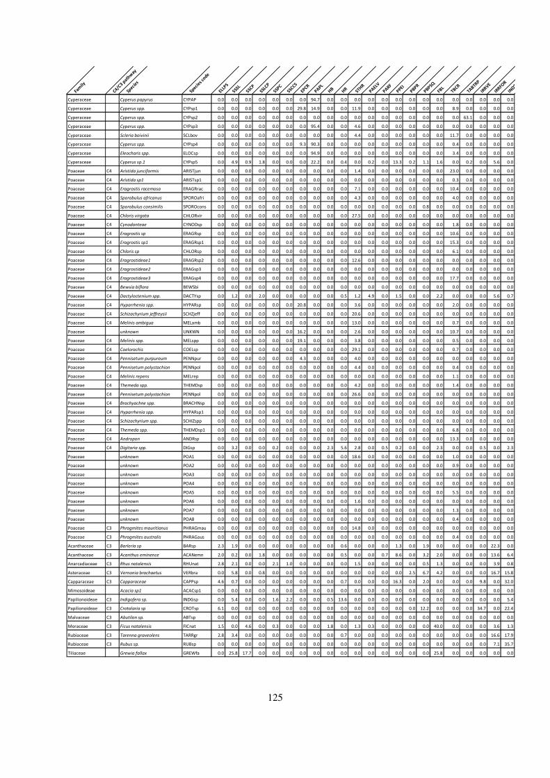
125
Fam
ily
C4/C3 p
athw
ay
Species
Species c
ode
ELLPS
SSSL
SSCP
SSLCP
SSPC
SSCCS
EPCRPAPL
HB
HR
STHR
PAELV
PARF
PPEIPBPR
PBPSQ
FBLTBCR
TABTR
P
IRRVE
IRRFO
R
INDT
Cyperaceae Cyperus papyrus CYPAP 0.0 0.0 0.0 0.0 0.0 0.0 0.0 94.7 0.0 0.0 0.0 0.0 0.0 0.0 0.0 0.0 0.0 0.0 0.0 0.0 0.0 0.0
Cyperaceae Cyperus spp. CYPsp1 0.0 0.0 0.0 0.0 0.0 0.0 29.8 14.9 0.0 0.0 11.9 0.0 0.0 0.0 0.0 0.0 0.0 8.9 0.0 0.0 0.0 0.0
Cyperaceae Cyperus spp. CYPsp2 0.0 0.0 0.0 0.0 0.0 0.0 0.0 0.0 0.0 0.0 0.0 0.0 0.0 0.0 0.0 0.0 0.0 0.0 63.1 0.0 0.0 0.0
Cyperaceae Cyperus spp. CYPsp3 0.0 0.0 0.0 0.0 0.0 0.0 0.0 95.4 0.0 0.0 4.6 0.0 0.0 0.0 0.0 0.0 0.0 0.0 0.0 0.0 0.0 0.0
Cyperaceae Scleria boivinii SCLbov 0.0 0.0 0.0 0.0 0.0 0.0 0.0 0.0 0.0 0.0 4.4 0.0 0.0 0.0 0.0 0.0 0.0 11.7 0.0 0.0 0.0 0.0
Cyperaceae Cyperus spp. CYPsp4 0.0 0.0 0.0 0.0 0.0 0.0 9.3 90.3 0.0 0.0 0.0 0.0 0.0 0.0 0.0 0.0 0.0 0.4 0.0 0.0 0.0 0.0
Cyperaceae Eleocharis spp. ELOCsp 0.0 0.0 0.0 0.0 0.0 0.0 0.0 94.9 0.0 0.0 0.0 0.0 0.0 0.0 0.0 0.0 0.0 3.4 0.0 0.0 0.0 0.0
Cyperaceae Cyperus sp.1 CYPsp5 0.0 4.9 0.9 1.8 0.0 0.0 0.0 22.2 0.0 0.4 0.0 0.2 0.0 13.3 0.2 1.1 1.6 0.0 0.2 0.0 5.6 0.0
Poaceae C4 Aristida junciformis ARISTjun 0.0 0.0 0.0 0.0 0.0 0.0 0.0 0.0 0.0 0.0 1.4 0.0 0.0 0.0 0.0 0.0 0.0 23.0 0.0 0.0 0.0 0.0
Poaceae C4 Aristida sp1 ARISTsp1 0.0 0.0 0.0 0.0 0.0 0.0 0.0 0.0 0.0 0.0 0.0 0.0 0.0 0.0 0.0 0.0 0.0 0.3 0.0 0.0 0.0 0.0
Poaceae C4 Eragrostis racemosa ERAGRrac 0.0 0.0 0.0 0.0 0.0 0.0 0.0 0.0 0.0 0.0 7.1 0.0 0.0 0.0 0.0 0.0 0.0 10.4 0.0 0.0 0.0 0.0
Poaceae C4 Sporobulus africanus SPOROafri 0.0 0.0 0.0 0.0 0.0 0.0 0.0 0.0 0.0 0.0 4.3 0.0 0.0 0.0 0.0 0.0 0.0 4.0 0.0 0.0 0.0 0.0
Poaceae C4 Sporobulus consimilis SPOROcons 0.0 0.0 0.0 0.0 0.0 0.0 0.0 0.0 0.0 0.0 0.0 0.0 0.0 0.0 0.0 0.8 0.0 0.0 0.0 0.0 0.0 0.0
Poaceae C4 Chloris virgata CHLORvir 0.0 0.0 0.0 0.0 0.0 0.0 0.0 0.0 0.0 0.0 27.5 0.0 0.0 0.0 0.0 0.0 0.0 0.0 0.0 0.0 0.0 0.0
Poaceae C4 Cynodonteae CYNODsp 0.0 0.0 0.0 0.0 0.0 0.0 0.0 0.0 0.0 0.0 0.0 0.0 0.0 0.0 0.0 0.0 0.0 1.8 0.0 0.0 0.0 0.0
Poaceae C4 Eragrostis sp ERAGRsp 0.0 0.0 0.0 0.0 0.0 0.0 0.0 0.0 0.0 0.0 0.0 0.0 0.0 0.0 0.0 0.0 0.0 10.6 0.0 0.0 0.0 0.0
Poaceae C4 Eragrostis sp1 ERAGRsp1 0.0 0.0 0.0 0.0 0.0 0.0 0.0 0.0 0.0 0.0 0.0 0.0 0.0 0.0 0.0 0.0 0.0 15.3 0.0 0.0 0.0 0.0
Poaceae C4 Chloris sp CHLORsp 0.0 0.0 0.0 0.0 0.0 0.0 0.0 0.0 0.0 0.0 0.0 0.0 0.0 0.0 0.0 0.0 0.0 6.1 0.0 0.0 0.0 0.0
Poaceae C4 Eragrostideae1 ERAGRsp2 0.0 0.0 0.0 0.0 0.0 0.0 0.0 0.0 0.0 0.0 12.6 0.0 0.0 0.0 0.0 0.0 0.0 0.0 0.0 0.0 0.0 0.0
Poaceae C4 Eragrostideae2 ERAGsp3 0.0 0.0 0.0 0.0 0.0 0.0 0.0 0.0 0.0 0.0 0.0 0.0 0.0 0.0 0.0 0.0 0.0 0.0 0.0 0.0 0.0 0.0
Poaceae C4 Eragrostideae3 ERAGsp4 0.0 0.0 0.0 0.0 0.0 0.0 0.0 0.0 0.0 0.0 0.0 0.0 0.0 0.0 0.0 0.0 0.0 17.7 0.0 0.0 0.0 0.0
Poaceae C4 Bewsia biflora BEWSbi 0.0 0.0 0.0 0.0 0.0 0.0 0.0 0.0 0.0 0.0 0.0 0.0 0.0 0.0 0.0 0.0 0.0 0.0 0.0 0.0 0.0 0.0
Poaceae C4 Dactyloctenium spp. DACTYsp 0.0 1.2 0.0 2.0 0.0 0.0 0.0 0.0 0.0 0.5 1.2 4.9 0.0 1.5 0.0 0.0 2.2 0.0 0.0 0.0 5.6 0.7
Poaceae C4 Hyparrhenia spp. HYPARsp 0.0 0.0 0.0 0.0 0.0 0.0 20.8 0.0 0.0 0.0 3.6 0.0 0.0 0.0 0.0 0.0 0.0 2.0 0.0 0.0 0.0 0.0
Poaceae C4 Schizachyrium jeffreysii SCHZjeff 0.0 0.0 0.0 0.0 0.0 0.0 0.0 0.0 0.0 0.0 20.6 0.0 0.0 0.0 0.0 0.0 0.0 0.0 0.0 0.0 0.0 0.0
Poaceae C4 Melinis ambigua MELamb 0.0 0.0 0.0 0.0 0.0 0.0 0.0 0.0 0.0 0.0 13.0 0.0 0.0 0.0 0.0 0.0 0.0 0.7 0.0 0.0 0.0 0.0
Poaceae unknown UNKWN 0.0 0.0 0.0 0.0 0.0 0.0 16.2 0.0 0.0 0.0 2.6 0.0 0.0 0.0 0.0 0.0 0.0 10.7 0.0 0.0 0.0 0.0
Poaceae C4 Melinis spp. MELspp 0.0 0.0 0.0 0.0 0.0 0.0 19.1 0.0 0.0 0.0 3.8 0.0 0.0 0.0 0.0 0.0 0.0 0.5 0.0 0.0 0.0 0.0
Poaceae C4 Coelorachis COELsp 0.0 0.0 0.0 0.0 0.0 0.0 0.0 0.0 0.0 0.0 29.1 0.0 0.0 0.0 0.0 0.0 0.0 0.7 0.0 0.0 0.0 0.0
Poaceae C4 Pennisetum purpureum PENNpur 0.0 0.0 0.0 0.0 0.0 0.0 4.3 0.0 0.0 0.0 4.0 0.0 0.0 0.0 0.0 0.0 0.0 0.0 0.0 0.0 0.0 0.0
Poaceae C4 Pennisetum polystachion PENNpol 0.0 0.0 0.0 0.0 0.0 0.0 0.0 0.0 0.0 0.0 4.4 0.0 0.0 0.0 0.0 0.0 0.0 0.4 0.0 0.0 0.0 0.0
Poaceae C4 Melinis repens MELrep 0.0 0.0 0.0 0.0 0.0 0.0 0.0 0.0 0.0 0.0 0.0 0.0 0.0 0.0 0.0 0.0 0.0 1.1 0.0 0.0 0.0 0.0
Poaceae C4 Themeda spp. THEMDsp 0.0 0.0 0.0 0.0 0.0 0.0 0.0 0.0 0.0 0.0 4.2 0.0 0.0 0.0 0.0 0.0 0.0 1.4 0.0 0.0 0.0 0.0
Poaceae C4 Pennisetum polystachion PENNpol 0.0 0.0 0.0 0.0 0.0 0.0 0.0 0.0 0.0 0.0 26.6 0.0 0.0 0.0 0.0 0.0 0.0 0.0 0.0 0.0 0.0 0.0
Poaceae C4 Brachyachne spp. BRACHNsp 0.0 0.0 0.0 0.0 0.0 0.0 0.0 0.0 0.0 0.0 0.0 0.0 0.0 0.0 0.0 0.0 0.0 0.0 0.0 0.0 0.0 0.0
Poaceae C4 Hyparrhenia spp. HYPARsp1 0.0 0.0 0.0 0.0 0.0 0.0 0.0 0.0 0.0 0.0 0.0 0.0 0.0 0.0 0.0 0.0 0.0 0.0 0.0 0.0 0.0 0.0
Poaceae C4 Schizachyrium spp. SCHIZspp 0.0 0.0 0.0 0.0 0.0 0.0 0.0 0.0 0.0 0.0 0.0 0.0 0.0 0.0 0.0 0.0 0.0 0.0 0.0 0.0 0.0 0.0
Poaceae C4 Themeda spp. THEMDsp1 0.0 0.0 0.0 0.0 0.0 0.0 0.0 0.0 0.0 0.0 0.0 0.0 0.0 0.0 0.0 0.0 0.0 6.8 0.0 0.0 0.0 0.0
Poaceae C4 Andropon ANDRsp 0.0 0.0 0.0 0.0 0.0 0.0 0.0 0.0 0.0 0.0 0.0 0.0 0.0 0.0 0.0 0.0 0.0 13.3 0.0 0.0 0.0 0.0
Poaceae C4 Digitaria spp. DIGsp 0.0 3.2 0.0 0.0 0.2 0.0 0.0 0.0 2.3 5.6 2.8 0.0 0.5 0.2 0.0 0.0 2.3 0.0 0.0 0.5 0.0 2.3
Poaceae unknown POA1 0.0 0.0 0.0 0.0 0.0 0.0 0.0 0.0 0.0 0.0 18.6 0.0 0.0 0.0 0.0 0.0 0.0 1.0 0.0 0.0 0.0 0.0
Poaceae unknown POA2 0.0 0.0 0.0 0.0 0.0 0.0 0.0 0.0 0.0 0.0 0.0 0.0 0.0 0.0 0.0 0.0 0.0 0.9 0.0 0.0 0.0 0.0
Poaceae unknown POA3 0.0 0.0 0.0 0.0 0.0 0.0 0.0 0.0 0.0 0.0 0.0 0.0 0.0 0.0 0.0 0.0 0.0 0.0 0.0 0.0 0.0 0.0
Poaceae unknown POA4 0.0 0.0 0.0 0.0 0.0 0.0 0.0 0.0 0.0 0.0 0.0 0.0 0.0 0.0 0.0 0.0 0.0 0.0 0.0 0.0 0.0 0.0
Poaceae unknown POA5 0.0 0.0 0.0 0.0 0.0 0.0 0.0 0.0 0.0 0.0 0.0 0.0 0.0 0.0 0.0 0.0 0.0 5.5 0.0 0.0 0.0 0.0
Poaceae unknown POA6 0.0 0.0 0.0 0.0 0.0 0.0 0.0 0.0 0.0 0.0 1.6 0.0 0.0 0.0 0.0 0.0 0.0 0.0 0.0 0.0 0.0 0.0
Poaceae unknown POA7 0.0 0.0 0.0 0.0 0.0 0.0 0.0 0.0 0.0 0.0 0.0 0.0 0.0 0.0 0.0 0.0 0.0 1.3 0.0 0.0 0.0 0.0
Poaceae unknown POA8 0.0 0.0 0.0 0.0 0.0 0.0 0.0 0.0 0.0 0.0 0.0 0.0 0.0 0.0 0.0 0.0 0.0 0.4 0.0 0.0 0.0 0.0
Poaceae C3 Phragmites mauritianus PHRAGmau 0.0 0.0 0.0 0.0 0.0 0.0 0.0 0.0 0.0 0.0 14.8 0.0 0.0 0.0 0.0 0.0 0.0 0.0 0.0 0.0 0.0 0.0
Poaceae C3 Phragmites australis PHRAGaus 0.0 0.0 0.0 0.0 0.0 0.0 0.0 0.0 0.0 0.0 0.0 0.0 0.0 0.0 0.0 0.0 0.0 0.4 0.0 0.0 0.0 0.0
Acanthaceae C3 Barleria sp BARsp 2.3 1.9 0.0 0.0 0.0 0.0 0.0 0.0 0.0 0.6 0.0 0.0 0.0 1.3 0.0 1.9 0.0 0.0 0.0 0.0 22.3 0.0
Acanthaceae C3 Acanthus eminence ACANemn 2.0 0.2 0.0 1.8 0.0 0.0 0.0 0.0 0.0 0.5 0.0 0.0 0.7 8.6 0.0 3.2 2.0 0.0 0.0 0.0 13.6 6.4
Anarcadiaceae C3 Rhus natalensis RHUnat 2.8 2.1 0.0 0.0 2.1 1.0 0.0 0.0 0.0 0.0 1.5 0.0 0.0 0.0 0.0 0.5 1.3 0.0 0.0 0.0 3.9 0.8
Asteraceae C3 Vernonia brachaetus VERbra 0.0 5.8 0.0 0.8 0.0 0.0 0.0 0.0 0.0 0.0 0.0 0.0 0.0 0.0 2.5 6.7 4.2 0.0 0.0 0.0 16.7 15.8
Capparaceae C3 Capparaceae CAPPsp 4.6 0.7 0.0 0.0 0.0 0.0 0.0 0.0 0.0 0.7 0.0 0.0 0.0 16.3 0.0 2.0 0.0 0.0 0.0 9.8 0.0 32.0
Mimosoideae Acacia sp1 ACACsp1 0.0 0.0 0.0 0.0 0.0 0.0 0.0 0.0 0.0 0.0 0.0 0.0 0.0 0.0 0.0 0.0 0.0 0.0 0.0 0.0 0.0 0.0
Papilionoideae C3 Indigofera sp. INDGsp 0.0 5.4 0.0 0.0 1.6 2.2 0.0 0.0 0.5 13.6 0.0 0.0 0.0 0.0 0.0 0.0 0.0 0.0 0.0 0.0 0.0 5.4
Papilionoideae C3 Crotalaria sp CROTsp 6.1 0.0 0.0 0.0 0.0 0.0 0.0 0.0 0.0 0.0 0.0 0.0 0.0 0.0 0.0 12.2 0.0 0.0 0.0 34.7 0.0 22.4
Malvaceae C3 Abutilon sp. ABTsp 0.0 0.0 0.0 0.0 0.0 0.0 0.0 0.0 0.0 0.0 0.0 0.0 0.0 0.0 0.0 0.0 0.0 0.0 0.0 0.0 0.0 0.0
Moraceae C3 Ficus natalensis FICnat 1.5 0.0 4.6 0.0 0.3 0.0 0.0 0.0 1.8 0.0 1.3 0.3 0.0 0.0 0.0 0.0 40.0 0.0 0.0 0.0 3.6 1.3
Rubiaceae C3 Tarenna graveolens TARRgr 2.8 3.4 0.0 0.0 0.0 0.0 0.0 0.0 0.0 0.7 0.0 0.0 0.0 0.0 0.0 0.0 0.0 0.0 0.0 0.0 16.6 17.9
Rubiaceae C3 Rubus sp. RUBsp 0.0 0.0 0.0 0.0 0.0 0.0 0.0 0.0 0.0 0.0 0.0 0.0 0.0 0.0 0.0 0.0 0.0 0.0 0.0 0.0 7.1 35.7
Tiliaceae Grewia fallax GREWfa 0.0 25.8 17.7 0.0 0.0 0.0 0.0 0.0 0.0 0.0 0.0 0.0 0.0 0.0 0.0 0.0 25.8 0.0 0.0 0.0 0.0 0.0

126
Appendix II: Names of phytolith morphotypes and their codes
Morphotypes names Morphotypes
codes Bilobate panicoid type BPT
Bilobate concave outer margin long shaft BCOMLS
Bilobate concave outer margin short shaft BCOMSS
Bilobate convex outer margin long shaft BXOMLS
Bilobate convex outer margin short shaft BXOMSS
Bilobate flattened outer margin long shaft BFOMLS
Bilobate flattened outer margin short shaft BFOMSS
Bilobate nodular MN
Bilobate flared, short shaft BFSS
Bilobate flared, long shaft BFLS
Bilobate notched/flared outer margin long shaft
BNFMLS
Bilobate notched/flared outer margin short shaft
BNFMSS
Trapezoids polylobates TPLY
Polylobate PLY
Quadralobate crosses QCR
Rondel ROND
Saddle SAD
Saddle long SADL
Saddle ovate SADO
Saddle plateau SADP
Saddle squat SADS
Tower flat TWF
Tower horned TWH
Tower wide TWD
Epidermal short cell (Rondels) EPDR
Epidermal Short cell(Saddles) EPDS
Epidermal short cell (Bilobate) EPIDB
b) Other morphotypes
Scutiform/prickles SCPR
Bulliform BLL
Carinate CR
Tracheids TRCH
Sclereids SCLD
Silica skeletons sensu lato SSSL
Silica skeleton with spheroids/ellipsoids cells
SSPEC
Silica skeleton jigsaw puzzle SSJP
Silica skeleton cylindroid cells sinuous SSCCS
Honey comb assemblage HYAS
Honeycomb elongates HYE
Honey comb spheroids HYSP
Spheroid echinate SPEC
Spheroid verrucate SPVE
Spheroid psilate SPPS

127
Spheroid Colpate SPCOL
Spheroid Scabrate SPSCA
Ellipsoid verrucate ELLVE
Ellipsoid scabrate ELLSC
Ellipsoid polylobates ELLPO
Ellipsoid Psilate ELLPS
Long cell wavy/polylobates LCWV
Papillae PAPL
Achene ACHN
Hair bases HB
Hair HR
Stomata STMT
Tabular Crenate TABCR
Parallepiped thin crenate PPTCR
Parallelepiped elongate verrucate PPEV
Parallepiped facetate PPFC
Parallepiped dendtric PPDT
Parallepiped elongate indeterminates. PPEL
Parallelepiped blocky psilate round heads PPBPR
Parallelepiped blocky scabrate PPBS
Parallelepiped thin psilate PPTP
Parallelepiped elongate thin scabrate PPELTS
Irregular Psilate IRRPS
Irregular scabrate IRRSC
Irregular verrucate IRRVE
Irregular forms IRRF
Indeterminable INDT
128
Appendix III: Occurrence of various morphotypes categories in the fossil assemblage (Raw data).

129
Tilia # 1 2 3 4 5 6 7 8 9 10 11 12 13 14 15 16 17 18 19 20 21 22 23 24 25 26 27
Sample # R35 R34 R33 R32 R31 R30 R29 R28 R27 R26 R25 R24 R15 R14 R13 R12' R12 R11 R10 R 8 R 9 R18 R17 R16' R16 R7 R6
Morphotype category
Tower wide (TWW) 11 13 8 5 7 14 6 13 5 20 26 40 10 9 7 22 15 40 18 15 13 2 9 17 10 30 24
Trapezoids Polylobate (TPLY) 0 0 0 0 0 0 0 0 3 1 0 7 5 4 0 3 8 8 2 0 0 0 0 6 1 1 3
Pooideae C3 grasses 61 139 39 27 25 43 15 70 66 28 120 147 104 114 34 131 194 119 97 26 70 36 55 73 72 104 123
Rondel (ROND) 50 126 31 22 18 28 8 57 58 7 92 100 89 101 27 106 171 70 77 11 57 34 46 50 61 73 96
Saddle ovate (SADO) 9 25 3 17 17 9 33 19 0 29 37 14 48 17 3 14 16 18 7 7 7 2 7 12 7 5 25
Tower flat (TWF) 11 7 0 13 3 13 5 1 9 12 32 17 6 5 0 6 4 14 6 0 9 0 8 10 9 1 9
Bilobate panicoid type (BPT) 19 24 1 45 11 29 9 14 11 11 36 17 10 32 2 42 16 23 46 12 3 3 0 1 15 24 6
Bilobate convex outer margin short shaft (BXOMSS) 42 106 21 49 31 34 29 46 46 15 64 128 74 88 11 151 172 60 53 36 27 11 8 25 81 59 41
Bilobate concave outer margin long shaft (BCOMLS) 3 11 0 21 5 1 6 6 0 6 24 8 9 10 0 10 11 27 7 0 3 0 0 0 2 3 3
Polylobate (PLY) 1 0 0 3 0 1 3 0 1 4 2 2 5 1 1 7 7 4 6 0 0 0 0 2 2 4 0
Tower horned (TWH) 10 19 6 5 12 19 10 16 6 23 33 20 18 5 7 9 16 28 12 12 15 0 13 10 9 8 9
Quadralobate crosses (QCR) 20 23 9 21 12 8 9 18 9 22 28 30 26 34 4 54 35 23 30 6 9 2 2 12 20 14 17
Bilobate concave outer margin short shaft (BCOMSS) 10 26 3 23 16 24 18 4 5 13 29 7 11 0 3 10 9 25 17 12 2 0 2 5 8 7 6
Saddle plateau (SADP) 7 36 8 27 13 29 10 15 2 17 45 38 7 23 8 25 27 18 15 4 6 3 7 14 14 17 19
Bilobate notched/flared outer margin long shaft (BNFMSS) 0 2 0 6 7 12 4 2 0 15 16 2 5 0 6 16 3 14 2 1 1 0 2 1 1 5 1
Bilobate convex outer margin long shaft (BXOMLS) 34 59 7 28 21 20 7 29 12 9 64 48 29 61 11 50 78 19 65 22 13 1 3 4 1 27 24
Saddle (SAD) 12 27 12 29 13 43 35 4 16 18 90 34 52 13 17 37 29 53 32 18 21 16 15 24 13 21 22
Saddle squat (SADSQ) 17 48 5 5 7 11 18 32 10 13 10 30 15 20 5 41 36 27 29 14 16 8 7 18 8 17 15
Bilobate flared, short shaft (BFSS) 14 18 0 45 19 22 3 2 6 0 24 16 4 1 0 5 17 14 22 6 1 2 0 2 1 6 4
Bilobate flared, long shaft (BFLS) 11 3 2 6 0 8 10 2 0 0 0 2 7 12 0 0 0 9 12 6 5 0 0 0 0 0 1
Bilobate flattened outer margin short shaft (BFOMSS) 52 53 12 68 26 47 29 26 17 18 66 51 60 81 29 77 71 67 66 28 10 8 6 17 28 34 29
Bilobate flattened outer margin long shaft (BFOMSS) 22 11 9 17 17 10 3 22 8 10 23 33 23 25 5 18 21 33 35 11 1 3 3 4 5 21 8
Bilobates indeter (BI) 22 14 4 22 8 4 2 10 1 9 14 5 6 8 2 5 7 15 8 2 0 1 0 4 0 8 5
Bilobate nodular (BN) 0 2 0 0 0 2 1 5 0 0 2 1 3 1 1 3 3 0 1 1 0 0 0 1 0 0 1
Scutiform/prickles (SCPR) 38 79 13 59 47 55 42 44 49 33 80 48 69 77 45 124 92 43 54 45 29 9 14 12 58 58 47
Bulliform (BLL) 8 13 5 13 8 10 8 7 8 7 28 25 23 21 8 21 12 12 10 14 19 20 32 10 13 16 26
Tracheids/ Schlereids (TRCH) 3 4 4 26 9 26 13 2 4 19 27 11 13 5 9 3 2 24 9 11 7 17 7 7 5 7 15
Mesophyl (MEPL) 0 0 0 0 2 0 0 0 0 0 0 0 3 2 0 1 15 0 0 0 2 1 1 0 5 0 0
Spheroid echinate (SPEC) 15 8 19 2 3 11 5 9 2 7 6 13 33 41 22 24 18 5 12 13 28 9 26 34 20 29 15
Spheroid verrucate (SPVE) 5 0 3 3 7 1 0 1 2 18 9 4 6 2 2 0 4 0 1 20 1 2 4 0 4 1 6
Spheroid psilate (SPPS) 28 46 11 8 21 10 9 59 16 19 51 73 89 121 22 52 46 31 62 88 72 17 24 38 56 90 60
Spheroid Scabrate (SPSCA) 11 30 10 14 29 13 10 17 23 8 18 19 45 40 7 17 13 15 27 59 30 21 13 47 35 25 18
Ellipsoid verrucate (ELLVE) 0 0 2 0 0 0 0 0 0 0 0 0 0 0 1 2 1 0 0 0 0 0 0 0 0 0 0
Irregular verrucate (IRRVE) 6 5 5 3 21 1 2 5 2 5 11 7 9 1 12 4 10 3 3 29 2 39 2 17 3 3 4
Irregular forms (IRRF) 1 1 2 7 9 7 26 5 16 8 11 4 0 0 0 0 11 12 0 17 3 30 7 74 7 11 3
Silica skeletons sensu lato (SSSL) 0 1 3 3 6 0 0 0 2 0 5 1 0 0 3 3 1 1 0 1 0 2 1 0 0 0 2
Honey comb elongate Psilate (HYEP) 0 1 0 2 0 0 0 0 0 4 0 0 0 0 0 0 0 0 2 0 0 0 0 0 0 0 0
Honey comb assemblage (HYAS) 0 0 0 0 5 1 0 0 4 0 1 2 0 0 1 0 4 3 3 0 0 0 0 0 1 3 1
Honeycomb elongates (HYE) 0 0 0 2 1 2 0 0 0 0 0 0 0 0 0 0 0 0 0 2 0 0 0 0 0 0 0
Honey comb spheroids (HYSP) 0 0 0 0 0 0 0 1 0 0 0 0 1 0 0 0 0 0 0 1 0 1 1 0 0 0 4
Long cell Psilate (LCPS) 1 0 1 0 0 3 0 4 0 1 3 1 1 0 2 0 0 0 2 3 0 2 0 4 1 0 0
long cell sinuate (LCSI) 0 0 0 0 2 0 0 0 0 0 2 0 0 0 0 0 0 0 0 0 1 0 0 0 0 0 0
Long cell dendritic (LCDE) 0 0 0 0 0 1 0 0 0 1 0 0 0 0 0 0 0 0 0 0 0 0 0 0 0 0 0
Long cell verrucate (LCVE) 0 0 2 0 1 1 0 0 0 0 2 0 0 2 0 0 0 0 0 0 0 1 1 0 0 0 1
Parallelepiped elongate verrucate (PPEV) 0 0 0 0 0 0 0 0 2 2 1 3 4 2 0 0 1 1 0 0 0 1 0 24 0 3 5
Parallelepiped thin psilate (PPTP) 0 0 1 0 0 2 0 3 6 11 10 3 0 0 3 1 1 0 0 4 2 3 2 11 4 1 0
Parallelepiped elongate thin scabrate (PPETS) 3 7 5 25 4 16 4 3 5 8 16 22 12 13 2 1 3 10 3 4 2 4 15 32 3 6 16
Hair (HR) 8 2 10 1 0 0 0 1 0 1 10 1 8 18 0 9 9 6 6 4 9 0 0 0 6 6 7
Papillae (PAPL) 1 0 0 0 0 1 0 2 0 0 0 6 5 0 1 0 0 3 2 1 0 0 0 0 0 3 1
Achene (ACHN) 21 18 7 7 7 1 3 20 15 1 10 6 39 33 13 13 14 39 10 24 10 1 13 11 17 14 5
Indeterminables 4 0 3 47 12 16 6 4 12 2 55 0 4 0 3 5 0 4 5 20 0 8 10 21 3 12 0

130
Appendix IV: Summary table showing diagnostic grass short-cell
morphotypes and the supporting literature
Grass sub-family Diagnostic Morphotypes/ Grass short-cell
phytoliths
Comparable previous studies
Pooideae Trapezoid polylobates
Tower wide
Barboni and Bremond, 2009
Roussouw, 2009
Arundinoideae Rondel
Saddle ovate
Tower wide
Piperno & Pearsall, 1998
Piperno, 2006; Fahmy, 2008
Mercader et al., 2010.
Panicoideae bilobates Panicoid type,
bilobates concave outer margin long shaft
bilobates convex outer margin outer margin
short shaft
Quadralobate
Tower horned
Fredlund & Tieszen 1994
Albert et al., 2005; Piperno, 2006
Fahmy, 2008
Mercader et al., 2010; 2011.
Chloridoideae bilobate flattened outer margins short/long
Saddle-shaped
Saddle squat
Tower flat
Piperno & Pearsall,1998
Fahmy, 2008
Mercader et al., 2010.
Aristidoideae Bilobates convex outer margin long shaft
Saddle plateau
Piperno and Pearsall, 1998
Piperno, 2006
Mercader et al., 2010
Undifferentiated grasses
Bulliforms
Prickle/scutiform
Madella et al., 2005
Mercader et al., 2010