Environmental Rehabilitation in a Rapidly Developing Urban Area

i
Initial Environmental Examination
January 2018
PHI: Integrated Natural Resources and Environmental Management ProjectRehabilitation and Improvement of Liguron Access Road
in Talakag, Bukidnon
Prepared by Municipality of Talakag, Province of Bukidnon for the Asian Development Bank.

ii
CURRENCY EQUIVALENTS (as of 30 November 2017 Year)
The date of the currency equivalents must be within 2 months from the date on the cover. Currency unit – peso (PhP)
PhP 1.00 = $ 0.01986 $1.00 = PhP 50.34
ABBREVIATIONS
ADB Asian Development Bank BDC Barangay Development Council BUB Bottom-Up Budgeting CDORB CNC CSC
Cagayan De Oro River Basin Certificate of Non-Coverage Construction Supervision Consultant
CSO Civil Society Organization DED Detail Engineering Design DENR Department of Environment And Natural Resources DILG Department of Interior and Local Government DSWD Department of Social Welfare and Development ECA Environmentally Critical Area ECC Environmental Compliance Certificate ECP Environmentally Critical Project EHSM Environmental Health and Safety Manager EIA Environmental Impact Assessment EIS Environmental Impact Statement EMB ESS
Environmental Management Bureau Environmental Safeguards Specialist
GAD Gender and Development IEE Initial Environmental Examination INREMP Integrated Natural Resources and Environment Management Project IP Indigenous People IROW Infrastructure Right of Way LIDASAFA LGU
Liguron-Dagundalahon-Sagaran Farmers Association Local Government Unit
LPRAT Local Poverty Reduction Action Team MKaRNP MKRNP MDC
Mt. Kalatungan Range Natural Park Mt. Kitanglad Range Natural Park Municipal Development Council
MPN Most Probable Number NAAQ National Ambient Air Quality Guidelines NCB National Competitive Bidding NECA Non-Environmental Critical Area NECP Non-Environmental Critical Project NIA National Irrigation Administration NPCO National Project Coordinating Office NRIMP National Road Improvement And Management Program

iii
NRM Natural Resources Management OMC Overhead, Contingencies And Miscellaneous And Contractor’s PAGASA Philippine Atmospheric Geophysical and Astronomical Services
Administration PDR Project Description Report PMIC Project Management Implementation Consultant PPCO Provincial Project Management
Offices PMO Project Management Office PMU Project Management Unit POs Peoples’ Organizations PSA Philippine Statistics Authority PWD Persons with Disability RC Reinforced Concrete RCPC Reinforced Concrete Pipe Culvert RPCO Regional Project Coordinating Offices REA Rapid Environmental Assessment ROW Right of Way SB Sangguniang Bayan SBD Standard Bidding Document SEMS Social and Environmental Management Systems SPMU Subproject Management Unit SPS SSS
Safeguard Policy Statement Social Safeguards Specialist
TA Technical Assistance TDS Total Dissolved Solids TOR Terms Of Reference TSP Total Suspended Particulates WMA WMC
Watershed Management Area Watershed Management Council
WMPCO Watershed Management And Project Coordination Offices

iv
WEIGHTS AND MEASURES
˚C – degree centigrade ha – hectare km – kilometer m – meter
m asl – meter above sea level mm – millimeter
mg/L – milligram per liter mg/Nm3 – milligram per normal cubic meter
ppt – parts per thousand μg/Nm3 – microgram per normal cubic meter
µS/cm – microSiemens/cm % – percent
NOTE
In this report, "$" refers to US dollars unless otherwise stated. This initial environmental examination is a document of the borrower. The views expressed herein do not necessarily represent those of ADB's Board of Directors, Management, or staff, and may be preliminary in nature. In preparing any country program or strategy, financing any project, or by making any designation of or reference to a particular territory or geographic area in this document, the Asian Development Bank does not intend to make any judgments as to the legal or other status of any territory or area.

v
TABLE OF CONTENTS
Page
I. EXECUTIVE SUMMARY .................................................................................................... 1 II. POLICY, LEGAL, AND ADMINISTRATIVE FRAMEWORK ................................................ 2 A. Environmental Clearance Requirements ............................................................................. 2
1. Government Environmental Laws, Regulations and Guidelines ....................................... 2 2. ADB Environmental Assessment Requirements .............................................................. 5
III. DESCRIPTION OF THE PROJECT .................................................................................... 6 A. Overview ............................................................................................................................. 6 B. Project Location .................................................................................................................. 6 C. Project Rationale ................................................................................................................. 7 D. Project Development Plan ................................................................................................... 8
1. Project Components ........................................................................................................ 8 2. Description of the Project Phases ...................................................................................10
E. Manpower Requirements ...................................................................................................11 F. Project Cost .......................................................................................................................11 G. Project Duration and Schedule ...........................................................................................12 IV. DESCRIPTION OF THE ENVIRONMENT ..........................................................................13 A. Elevation and Slope ...........................................................................................................13 B. Geology .............................................................................................................................13 C. Soils ...................................................................................................................................15 D. Land Classification .............................................................................................................16 E. Land Cover and Land Use .................................................................................................17 F. Climate ..............................................................................................................................19
1. Baseline Climate ............................................................................................................19 2. Climate scenario for Bukidnon Province in 2020 and 2050 .............................................20
G. Hydrology...........................................................................................................................21 H. Water Quality .....................................................................................................................22 I. Natural Hazards .................................................................................................................23 J. Biological Environment .......................................................................................................23 K. Socio-Economic Conditions ...............................................................................................24
1. Population ......................................................................................................................24 2. Population Density .........................................................................................................25 3. People’s Organization ....................................................................................................26 4. Education .......................................................................................................................26 5. Livelihood and Income ....................................................................................................27 6. Agriculture ......................................................................................................................28 7. Agroforestry and Plantation Areas ..................................................................................28 8. Fisheries .........................................................................................................................29 9. Health and Sanitation .....................................................................................................29 10. Tourism and Recreation ..............................................................................................30 11. Access to Safer Water and Electricity .........................................................................31 12. Communication ...........................................................................................................31 13. Road Access and Transportation ................................................................................32
V. ANTICIPATED ENVIRONMENTAL IMPACTS AND MITIGATION MEASURES ................32 A. Pre-Construction ................................................................................................................34

vi
1. Confirmation of no required resettlement, relocations, and compensation ......................34 2. Identification and prioritization of road section where re-gravelling will be done ..............34 3. Preparation of detailed engineering designs and programs of work ................................34 4. Recruitment of workers ...................................................................................................34
B. Construction .......................................................................................................................35 1. Construction materials acquisition, transport access, and storage system ......................35 2. Clearing and removal of obstructions .............................................................................35 3. Soil erosion ....................................................................................................................35 4. Ground surface leveling and gravelling of existing road ..................................................36 5. Civil works ......................................................................................................................36 6. Implementation of noise and dust control measure .........................................................36 7. Dust and noise from borrow pits .....................................................................................36 8. Implementation of spoil management and control measure ............................................37 9. Solid and liquid construction waste management system ...............................................37 10. Water quality ...............................................................................................................37 11. Construction drainage system .....................................................................................37 12. Workers health, safety and hygiene ............................................................................38 13. Traffic safety and management ...................................................................................38 14. Ecological environment (Flora and Fauna) ..................................................................38 15. Damaged to properties ...............................................................................................39 16. Concrete washout .......................................................................................................39 17. Use of Hazardous Substances ....................................................................................39 18. Public safety ...............................................................................................................39
C. Operation and Maintenance (O&M) Phase.........................................................................40 1. Operation of upgraded access road ................................................................................40
VI. INFORMATION DISCLOSURE, CONSULTATION, AND PARTICIPATION ......................40 A. Stakeholder Consultations .................................................................................................40 B. Information Disclosure .......................................................................................................43 VII. GRIEVANCE REDRESS MECHANISM .............................................................................44 VIII. ENVIRONMENTAL MANAGEMENT PLAN .......................................................................46 A. Implementation Arrangements ...........................................................................................46 B. Environmental Mitigation ....................................................................................................48 C. Environmental Monitoring ..................................................................................................58 IX. CONCLUSION AND RECOMMENDATION .......................................................................61 A. Conclusion .........................................................................................................................61 B. Recommendation ...............................................................................................................61

vii
LIST OF FIGURES
Figure 1: Location of the Proposed Rehabilitation and Improvement of the ................................ 7 Figure 2: Elevation and Slope of the Proposed Road Rehabilitation Project ..............................14 Figure 3: Land Classification Map of CDORB ...........................................................................17 Figure 4: Land Cover Map of the CDORB .................................................................................18 Figure 5: Record of tropical cyclones that passed through the region covering the influence watersheds during the period 1948 - 2009 (PAGASA) .........................19 Figure 6: Monthly rainfall based on CNCM3 model for 2020s and 2050s periods in Bukidnon Province ................................................................................................21 Figure 7: Subwatersheds of the Cagayan de Oro River Basin ...................................................22
LIST OF TABLES
Table 1: Summary List of ECP Types and ECA Categories ....................................................... 3 Table 2: Revised Guidelines for Coverage Screening and Standardized Requirements ............. 4 Table 3: Breakdown of cost estimates for the road rehabilitation and improvement project .......12 Table 4: Implementation Schedule ............................................................................................13 Table 5: Describes the geology inside the river basin ...............................................................14 Table 6: Soil Type Distribution inside the CDORB .....................................................................15 Table 7: Land Classification of CDORB ....................................................................................16 Table 8: Land Use/Land Cover of Talakag, Bukidnon ...............................................................18 Table 9: Projected monthly rainfall based on CNCM3 model with A1b and A2 scenarios for 2020s and 2050s periods in Bukidnon Province ....................................20 Table 10: Change anomalies of rainfall in Bukidnon Province based on CNCM3 model ...........21 Table 11: Members of Indigenous Tribe by Sex, by Barangay ..................................................24 Table 12: Population Density ....................................................................................................25 Table 13: Historical Enrolment, SY 2014-2015 ..........................................................................26 Table 14: Schools in the Influence Areas ..................................................................................26 Table 15: LGU Income ..............................................................................................................27 Table 16: Income per Capita .....................................................................................................27 Table 17: Sources of Income ....................................................................................................28 Table 18: Area Devoted to Agricultural Production ....................................................................29 Table 19: Existing Barangay Health Stations ............................................................................30 Table 20: Tourist Attractions by Municipality .............................................................................30 Table 21: Household Access to Potable Water .........................................................................31 Table 22: Households Served and Unserved by Electricity .......................................................31 Table 23: Assessment of Potential Environmental Impacts .......................................................33 Table 24: Summary of Stakeholder Views of the Road Rehabilitation and Improvement in Talakag .............................................................................................41 Table 25: Responsibilities for EMP Implementation ..................................................................46 Table 26: Environmental Impact Mitigation Plan ........................................................................48 Table 27: Environmental Monitoring Plan ..................................................................................59

viii
LIST OF APPENDIXES
Appendix 1: A Copy of the LGU Talakag Application for Tree Cutting Permit ............................63 Appendix 2: A copy of Barangay Officials Resolution of Support and No Objection To The Proposed Subproject ...........................................................64 Appendix 3: A copy of LIDASAFA Minutes of the Meeting and Resolution of Support to the Proposed Subproject .................................................................69 Appendix 4: Minutes/Attendance/Photos - Consultation Meeting with the IPs ...........................75 Appendix 5: Sangguniang Bayan Resolution ............................................................................80 Appendix 6: Minutes of the Public Consultation on July 7, 2017 ................................................82 Appendix 7: Grievance Intake Form ..........................................................................................87

1
I. EXECUTIVE SUMMARY
1. This Initial Environmental Examination has been prepared for the Rehabilitation and Improvement of Liguron Access Road in Talakag, Bukidnon. This Subproject is the rehabilitation and improvement of the existing access road with an estimated length of 2 km, width of 3 m, and shoulder of (0.5) meter on both sides. The main proponent of the project is the Local Government Unit of Talakag, Bukidnon assisted by Department of Environment and Natural Resources – Integrated Natural Resources and Environmental Management Project. The project implementation will be co-managed by the Municipal Planning and Development Coordinator and the Municipal Engineer. 2. The objective of the Rehabilitation and Improvement of Liguron Access Road is uplifting the quality of life of the people thru the provision of all-year-round easy and affordable access thereby improving the prompt delivery of basic services, increasing economic opportunities and conditions. The proposed access road will support the NRM project activities of the constituents. 3. The Subproject has been categorized by ADB as Environment Category B and this IEE was prepared consistent with the environmental assessment requirements of ADB’s Safeguard Policy Statement of 2009. The IEE was carried out through screening and analysis of various environmental parameters, field investigations, stakeholder consultations, and review of other road project reports in the Philippines. The IEE covers the general environmental profile of Talakag rural infrastructure subproject and includes an assessment of the potential environmental impacts during different subproject phases and formulation of corresponding mitigation measures. The IEE was prepared by the LGU of Talakag in cooperation with RPCO, PMU, WMCO and POs. 4. The total cost of the subproject is Seventeen Million Seven Hundred Eighty Thousand Seven Hundred Forty Three Pesos & 72/100 Centavos (Php 17,780,743.72). The project funding source is majority coming from the DENR - INREMP and LGU with a cost sharing of 80% and 20%, respectively. It will be assumed that the benefits of the subproject will be the reduction of travel time by 15 minutes, freight cost by 60%, passenger fare by 38% and availability of infrastructure support for NRM projects and other agricultural livelihood projects of the community.
5. Major land use along the road rehabilitation project is agriculture which is part of production forest. None of the subproject roads are located near or within ecologically sensitive areas. 6. The IEE, based on the screening of baseline environment and review of proposed civil works, has not identified any major environmental concerns due to proposed rehabilitation and improvement of Liguron access road given that all the proposed civil works are only asset preservation of existing roadway and are located within existing right of way. There will only be localized short-term impacts during construction activities due to implementation of civil works that will be addressed in the detailed design and through implementation of the mitigation and monitoring measures specified in the environmental management plan.
7. The IEE process included stakeholder participation and consultation to help LGUs achieve public acceptance of the subproject. A series of consultations with its influenced barangay (Liguron) of the local government of Talakag confirmed that the rehabilitation and improvement of the Liguron access road is essential for economic development.

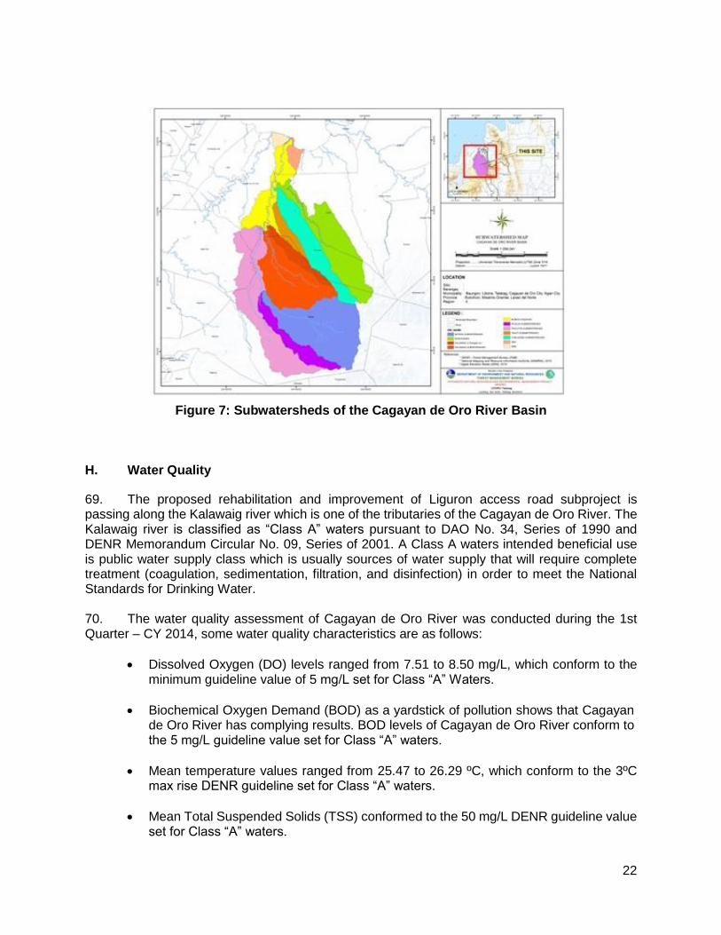
2
8. A grievance redress mechanism will be established by the LGU of Talakag prior to commencement of site works to ensure that complaints of affected persons and other stakeholders regarding the project’s environmental performance are promptly addressed. 9. The IEE includes an environmental management plan which details the mitigation measures, environmental monitoring activities, institutional responsibilities, and environmental management capacity building. The LGU through its Municipal Planning and Development Coordinator and the Municipal Engineer will ensure that relevant EMP provisions are included in bid and contract documents for detailed design, project supervision and civil works. During construction, they will closely conduct monitoring the contractor’s environmental performance and over-all EMP implementation. Semi-annual environmental monitoring reports will be submitted by LGU to ADB and such reports will be posted on ADB’s website for public disclosure. 10. The major positive impact of the project will be economic and better accessibility. The subproject will directly benefit people located within the barangay providing improved access and economic development. The subproject would also benefit the environment in terms of reduced soil erosion and landslides through slope stabilization measures and construction of retaining structures. Dust generation from the damaged roads will be reduced by the improvement of pavement. Health risk to the roadside communities and damage to the biological environment will be reduced due to pavement improvement and soil erosion control measures.
11. This Subproject will have overall beneficial impact and will have minor negative impacts that will be carefully monitored and adequately mitigated through implementation of the EMP.
II. POLICY, LEGAL, AND ADMINISTRATIVE FRAMEWORK
A. Environmental Clearance Requirements
1. Government Environmental Laws, Regulations and Guidelines
12. According to the EMB Memorandum Circular 005 - 2014, the environmental category of a project is decided based on the type of the project (whether it falls into ‘Environmental Critical Project’, ECP type), location of the project (whether it falls into ‘Environmental Critical Areas’, ECA category), and size of the project. A summary list of ECPs and ECA categories are presented in Table 1.

3
Table 1: Summary List of ECP Types and ECA Categories
A. List of ECPs
As declared by Proclamation No. 2146 (1981)
1. Heavy Industries – Non-ferrous Metal Industries, Iron and Steel Mills, Petroleum and Petro-chemical Industries including Oil and Gas, Smelting Plants
2. Resource Extractive Industries – Major Mining and Quarrying Projects, Forestry Projects (logging, major wood processing projects, introduction of fauna (exotic animals) in public and private forests, forest occupancy, extraction of mangrove products, grazing), Fishery Projects (dikes for/ and fishpond development projects)
3. Infrastructure Projects – Major Dams, Major Power Plants (fossil-fueled, nuclear fueled, hydroelectric or geothermal), Major Reclamation Projects, Major Roads and Bridges
As declared by Proclamation No. 803 (1996)
4. All golf course projects
B. List of ECA Categories - As declared by Proclamation No. 2146 (1981)
1. All areas declared by law as national parks, watershed reserves, wildlife preserves, sanctuaries
2. Areas set aside as aesthetic potential tourist spots
3. Areas which constitute the habitat of any endangered or threatened species of Philippine wildlife (flora and fauna)
4. Areas of unique historic, archaeological, or scientific interests
5. Areas which are traditionally occupied by cultural communities or tribes
6. Areas frequently visited and/or hard-hit by natural calamities (geologic hazards, floods, typhoons, volcanic activity, etc.)
7. Areas with critical slopes
8. Areas classified as prime agricultural lands
9. Recharged areas of aquifers
10. Water bodies characterized by one or any combination of the following conditions: tapped for domestic purposes; within the controlled and/or protected areas declared by appropriate authorities; which support wildlife and fishery activities
11. Mangrove areas characterized by one or any combination of the following conditions: with primary pristine and dense young growth; adjoining mouth of major river systems; near or adjacent to traditional productive fry or fishing grounds; areas which act as natural buffers against shore erosion, strong winds and storm floods; areas on which people are dependent for their livelihood.
12. Coral reefs characterized by one or any combination of the following conditions: With 50% and above live coralline cover; Spawning and nursery grounds for fish; Act as natural breakwater of coastlines
13. Based on their type, size and location the projects have been classified into 3 major groups:
• Group I (ECPs): ECPs in either ECAs or NECAs – Environmentally Critical Projects in either Environmentally Critical Areas or Non-Environmentally Critical Areas. These projects require the proponent to submit ‘Environmental Impact Statement’ report to secure ‘Environmental Compliance Certificate’ from DENR’s Environment Management Bureau (EMB). Table 2 gives the size of the road and bridge projects that fall in to Group 1.
• Group II (NECPs): NECPS in ECAs – Non Environmentally Critical Projects in Environmentally Critical Areas. These projects require proponent to submit either ‘Initial Environmental Examination’ Report or ‘Project Description Report ‘ based on the size of the project (Table 2) to secure either ECC or ‘Certificate of Non Coverage’.

4
• Group III (Non Covered Projects): NECPs in NECS – Non Environmentally Critical Projects in Non Environmentally Critical Areas. PDR required to be submitted for Enhancement Mitigation Projects for confirmation of benign nature of proposed activity, and CNC is required to be secured. All other projects shall be at the option of the proponent to prepare a PDR as a basis for CNC, should the proponent opt to secure one.
14. This subproject is an improvement of existing barangay road which falls under the group of Non-ECP. Given that the subproject is the rehabilitation of access road with no more than 50% increase in capacity, a Certificate of Non-coverage (CNC) was requested by the LGU to the Environmental Management Bureau (EMB) Region 10. This CNC application was released on May 29, 2017.
Table 2: Revised Guidelines for Coverage Screening and Standardized Requirements
Projects within the INREMP Menu of
Subprojects
Covered (Required to secure ECC) Not covered
(may secure CNC) Project size parameters /
Remarks CATEGORY A: ECP CATEGORY B: Non-ECP CATEGORY D
EIS EIS IEE Checklist Project Description
(Part I only)
3.1Dams, Water
Supply and Flood Control Project
3.1.1DAMS (including those for irrigation, flood control, water source and hydropower projects) including run-of-river type
≥ 25 hectares OR ≥ 20 million m3
>5 hectares but <25 hectares OR >5 million m3 but <20 million m3
≤5 hectares AND
≤5 million m3 NONE
Reservoir flooded/inundated area or/and water storage
capacity
3.1.2Irrigation projects (distribution system only)
NONE ≥1,000 hectares (service area)
>300 but <1,000
hectares ≤300 hectares Service area
3.1.3 Water Supply Projects (without dam)
NONE
With water source (e.g.
infiltration gallery, etc.) and water
treatment facilities including
desalination, reverse osmosis
(RO)
Level III (Distribution system only)
Level II / Level I Water refilling station
3.4 Roads and Bridges
3.4.2 Roads, widening, rehabilitation and/or improvement
NONE
>50% increase in capacity (or in
terms of length/width)
AND ≥20km, (length with no critical
slope) OR ≥10km (length with
critical slope)
>50% increase in
capacity (or in terms of
length/width) AND
>2km but <20km,
(length with no critical slope) OR
≥10km (length with critical
slope)
>50% increase in capacity (or in terms of length/width) BUT
≤ 2km increase in length

5
Projects within the INREMP Menu of
Subprojects
Covered (Required to secure ECC) Not covered
(may secure CNC) Project size parameters /
Remarks CATEGORY A: ECP CATEGORY B: Non-ECP CATEGORY D
EIS EIS IEE Checklist Project Description
(Part I only)
3.4.3 Bridges and viaducts (including elevated roads), new construction
≥10km ≥5km but <10km >50m but
<5km
≤50m Regardless of length for footbridges or for
pedestrian only
3.4.4 Bridges and viaducts (including elevated roads), rehabilitation and/or improvement
NONE
≥50% increase in capacity (or in
terms of length/width) OR
≥10km
>50% increase in
capacity (or in terms
length/width) but <total length of
10km
≤50% increase in capacity (or in terms of length/width) but ≤2km increase in
length
3.6 Buildings including Housing, Storage facilities and Other Structures
3.6.2 Storage facilities with no hazardous or toxic materials.
NONE ≥ 5 hectare >1 hectare
but <5 hectare
≤ 1 hectare
Total/gross floor area including
parking, open space and other areas
2. ADB Environmental Assessment Requirements
15. According to ADB guidelines, the process of determining a project’s environment category is to prepare a Rapid Environmental Assessment screening checklist, taking into account the type, size, and location of the proposed project. Based on ADB’s Safeguard Policy Statement 2009 (SPS 2009), a project is classified as one of the four (4) environmental categories (A, B, C or FI) as follows:
• Category A: Projects with potential for significant adverse environmental impacts that are irreversible, diverse or unprecedented. These impacts may affect an area larger than the sites or facilities subject to physical works. An environmental impact assessment is required.
• Category B: Projects judged to have some adverse environmental impacts, but of lesser
degree and/or significance than those for category A projects. Impacts are site-specific, few if any of them are irreversible, and in most cases mitigation measures can be designed more readily than for Category A projects. An initial environmental examination (IEE) is required.
• Category C: Projects likely to have minimal or no adverse environmental impacts. No
environmental assessment is required although environmental implications are still reviewed.
• Category FI: Projects are classified as category FI if they involve investment of funds to or through a financial intermediary. Where the FI’s investment have minimal or no adverse environmental risks. The FI project will be treated as Category C. All other FI’s must

6
establish and maintain an environmental and social management system and must comply with the environmental safeguards requirements specified in SPS 2009 if the FI’s subprojects have the potential for significant adverse environmental impacts.
16. According to Philippines environmental guidelines, the Project or Subproject can be considered as either under Group II or III while ADB has categorized the Project as environment Category B. Hence, this IEE has been prepared to meet the requirements of both the ADB and the government. Upon ADB’s receipt of the final IEE from the proponent, this will be publicly disclosed through posting on ADB’s website.
III. DESCRIPTION OF THE PROJECT
A. Overview
17. The general objective of the Rehabilitation and Improvement of Liguron Access Road is uplifting the quality of life of the people thru the provision of all-year-round easy and affordable access thereby improving the prompt delivery of basic services, increasing economic opportunities and conditions. The proposed access road will support the national resources management project activities of the constituents. 18. To ensure accessibility of communities of basic social services delivery, repair and maintenance of roads, spillways and drainage systems are among the infrastructure concerns identified by the community and specifically expressed in their Barangay Development Plans for specific funding assistance by the local government unit. B. Project Location
19. The municipality of Talakag belongs to the northern part of the Province of Bukidnon. It is the second largest municipality next to the municipality of Impasug-ong in terms of land area. Talakag lies within the grid coordinates 124°30” to 124°50 east longitude and 7°55” to 8°20” north latitude. It is a land-locked municipality. 20. The project is a rehabilitation and improvement of the existing barangay road with a length of 2 kilometers, width of 3 meters and shoulder of one (0.5) meter on both sides. The project starts at the provincial road at Barangay Liguron and ends at the Sitio Limonsod. The location of the project is shown in Figure 1. 21. Based on the environmental characterization of the project site done during the field reconnaissance survey, the project was not located in an environmentally critical area and the field data were supplemented with secondary information gathered from the DENR Regional Office and CENRO and other relevant data such as watershed management plan, environmental reports and feasibility studies undertaken by national and local agencies.

7
Figure 1: Location of the Proposed Rehabilitation and Improvement of the Liguron Access Road
C. Project Rationale
22. The proposed subproject is located within alienable and disposable (A&D) land and community-based forest management (CBFM) areas starting from Liguron proper to Sitio Limonsod. It is a 2.0 km access road network connecting the barangay influence area of Cosina. Limonsod is approximately 17.5 km away from the Central Business District (CBD). Currently, the people living in the barangay are using the said road to transport their farm produce to the market but they are faced with the challenge in mobility and accessibility to goods and services for their own consumption. Women who are the main seller and trader of the farm produce of their family transport their products to the market using motorcycles with a higher fare or walking to the municipal road. Children from Liguron who are going to school every day are also using the existing road. Senior citizens, persons with disability (PWDs), the riding public and people with health problems going to the basic public services like health centers, hospital, barangay halls, municipal hall, police stations and etc. are also using the existing road. 23. The main livelihood of the community within the influenced barangay is farming. However, these activities are very much affected by the poor condition of the road. During rainy season, the road becomes muddy and hardly passable. Based on the data above, health is an issue and they need access to more additional health services. The transport condition also makes the fare rates high so people tend to get their basic needs from unscrupulous businessmen engaged in trading or middlemen in the area. Also, quality of farm produce transported to the main market will be low if the road is rough. The lack of access also deprives them of the ability to take advantage of job opportunities. 24. During a series of consultations with the municipal and barangay officials, the major problem identified by the community was the poor access road. The farmers were forced to sell

8
their agricultural products to the traders who came into the area at low price they dictate to the farmers and deal with higher cost of transportation and hauling if they sell them to the market. 25. There will be many opportunities that this rehabilitated access road will bring foremost of which will be the ease of access. There will be additional income of the farmers brought by less time in transporting their produce and finish products, the increase of enrolment of elementary pupils from barangay Liguron, the decrease of maternal and infant mortality rate due to the increase of frequency of health personnel going to the area, and the decrease of transportation fare rates due to the reduction of vehicular operating cost Given that the residents in Brgy. Kidapawan which are mostly farmers, it will boost the socio-economic well-being of the barangay if these facilities are provided to them. Improvement of the road network in the barangay will lead to easy access in the upland area, the farmers’ community and to the established NRM subproject sites. As one of the basic support facility to achieve the goals of rehabilitating the forest and the watershed, the rehabilitation of the road will be essential. 26. Direct employment during the construction will increase. Labor, skilled and unskilled, will be from the barangay and women can also be employed. It may address some of the poverty situation as it decreases costs and prices and enhances trade and employment opportunities. Transportation indirectly alleviates poverty. The lack of access deprives them of the ability to take advantage of job opportunities and even of very basic social services. Reliable access to schools and health services for the poor contributes directly to their accumulation of human capital, which is a key factor in sustainable poverty alleviation in as much as jobs and basic social services are relatively highly valued by the poor. Thus, improvements in road transport, public or private, in Liguron access road would have powerful positive effects on the poorer parts of the population. D. Project Development Plan
1. Project Components
27. The proposed project is the Rehabilitation and Improvement of Liguron-Access Road. The existing road network has presently a width of 4 m with about 2,000 linear m in length. Its spillway at Station 0+190-0+215 needs flooring. Another spillway is to be installed at Station 0+618. There is also a need to install a cross drainage at Stations 0+050, 0+500, 0+760 and 1+020 in order to minimize water runoff. The rehabilitation and improvement activities will include Roadway Excavation (102), Excavation for Structure (103), Sub-grade Preparation (105), Aggregate Base Coarse (201), Concrete Works (Spillway, Wing Wall and Headwall), Pipe Culverts (500), Portland Cement Concrete Pavement (311), Grouted Riprap (505) and SPL-1 Carpentry Works. The quarry site for Base Coarse (201) is at Cagayan de Oro City which is approximately 36 kilometers away from Talakag proper and takes about 1 hour of travel time. The specifications for the scope of work are further described below using the DPWH Blue Book standards:
Item 102: Excavation This item shall consist of roadway and drainage and borrow excavation and the disposal of material in accordance with Specifications and in conformity with the lines, grades, and dimensions to be shown on the Plans or established by the Engineer. Excavated materials that are suitable will be used in the embankment to minimize hauling cost of filling materials. While unsuitable materials will be brought to the municipal waste disposal facility for covering materials. A bulldozer will be required for this work item.

9
Item 103: Structure Excavation
This item shall consist of the necessary excavation for foundation of culverts, under drains, and other structures not otherwise provided for in the Specifications using backhoe equipment. Except as otherwise provided for pipe culverts, the backfilling of completed structures and the disposal of all excavated surplus materials, shall be in accordance with these Specifications and in reasonably close conformity with the Plans or as established by the Engineer.
This item shall include necessary diverting of live streams, bailing, pumping, draining, sheeting, bracing, and the necessary construction of cribs and cofferdams, and furnishing the materials therefore, and the subsequent removal of cribs and cofferdams and the placing of all necessary backfill.
It shall also include the furnishing and placing of approved foundation fill material to replace unsuitable material encountered below the foundation elevation of structures. No allowance will be made for classification of different types of material encountered.
Item 105: Sub-grade Preparation
This item shall consist of the preparation of the subgrade for the support of overlying structural layers. It shall extend to full width of the roadway. Unless authorized by the Engineer, sub-grade preparation shall not be done unless the Contractor is able to start immediately the construction of the pavement structure. Grader and road roller equipments shall be required for this item. Item 201: Aggregate Base Course
This item shall consist of furnishing, placing, and compacting an aggregate base course on a prepared sub-base in accordance with Specifications and the lines, grades, thickness, and typical cross-sections shown on the Plans, or as established by the Engineer. Equipment requirements are grader and road roller.
Item 405: Structural Concrete
This item shall consist of furnishing, bending, placing, and finishing concrete in all structures except pavements in accordance with Specifications and conforming to the lines, grades, and dimensions shown on the Plans. Concrete shall consist of a mixture of Portland Cement, fine aggregate, coarse aggregate, admixture when specified, and water mixed in the proportions specified or approved by the Engineer. A concrete vibrator and concrete mixer will be required for this work item.
Item 500: Pipe Culverts and Storm Drains
This item shall consist of the construction or reconstruction of pipe culverts and storm drains, hereinafter referred to as “conduit” in accordance with Specifications and in conformity with the lines and grades shown on the Plans or as established by the Engineer.

10
Item 311: Portland Cement Concrete Pavement (PCCP)
This item shall consist of pavement of Portland Cement Concrete without reinforcement, constructed on the prepared base in accordance with Specifications and in conformity with lines, grades, thickness, and typical cross-section shown on the Plans. Equipment requirements are the concrete mixer, concrete vibrator, concrete cutter, bar cutter and water truck.
Item 505: Grouted Riprap
This Item shall consist of the furnishing and placing of riprap with or without grout as the case may be, with or without filter backing, furnished and constructed in accordance with this Specification and to the lines and grades and dimensions shown on the Plans.
2. Description of the Project Phases
a. Pre-Construction Phase/Pre-Development Phase
28. The pre-construction phase involves the social preparation (to include organizational strengthening, planning, identification and prioritization of community needs) of the community for the entry of the project to the site, conduct of pre-engineering activities covering detailed survey works to determine alignment of roads and canal systems, preparation of the detailed engineering plans and programs of work, ROW negotiation, recruitment of work force and initial sourcing and procurement of construction materials. These activities will be conducted by the proponent technical staff, partner line agencies, NGO service providers, community beneficiaries especially the Peoples’ organizations and contractors.
b. Construction/Development Phase
29. The construction phase involves the mobilization of construction equipment, construction workers and materials to the specific project site after which the longer period of actual construction work will commence. The construction phase will end with the demobilization of construction equipment, workers and other construction paraphernalia from the construction site. Majority of these activities will be undertaken by the contractor and community residents under the close supervision of the Subproject Management Unit.
c. Operation Phase and Maintenance Phase
30. This phase involves the actual maintenance of the rehabilitated access road during its expected economic life. Monitoring tools and parameters will be set forth in the MOA that the LGU and DENR will sign to ensure sustainability of the constructed facility. The specific monitoring items and parameters, location and frequency, monitoring responsibilities and sources of budget are presented in the EIAMMP.
d. Abandonment Phase
31. This phase is included in the project demobilization. The proponent does not intend to abandon any facilities and unserviceable equipment used during construction. The project location will not be abandoned in disorderly condition but instead restored for functional use.
11
Following the completion of the construction, the proponent will dismantle temporary shelters and the construction yard including unserviceable vehicles and equipment.
32. Wastes arising from the abandonment are expected to be minimal. These wastes could include small volumes of left over sand and gravel, re-bars and other steel materials (i.e., nails and welding roads) and lumber. E. Manpower Requirements
33. Construction activities will require hiring of skilled and unskilled manpower. It is assumed that some skilled, semi-skilled and unskilled manpower will be available in the area. Skilled manpower not available in the locality may be sourced from other nearby localities. Technical manpower will be a complementation of specialists to be provided by locally known engineering firms. 34. During the construction phase, a workforce consisting of contractual and regular laborers will be employed to carry out the construction of the proposed project. 35. The Contractor shall employ qualified and sufficient staff to carry out inspections, testing and monitoring for the project. F. Project Cost
36. The Subproject Cost as estimated has the total amount of Php 17,780,743.72 which includes the costs for the indirect cost and taxes aside from the direct cost (material + labor + equipment). Said direct cost has the amount of PhP 13,568,943.62. The overhead, contingencies and miscellaneous and contractor’s (OMC) profit will be 8% and 9% of the direct cost, respectively. Taxes will be in the fixed ratio of 12% as required by the government.
37. Following the agreed financing mix of the subproject, 80% of the total Subproject Cost as presented will be covered by the Project and the remaining 20% will be borne by the proponent LGU-Talakag as equity counterpart which will be appropriated by the Sangguniang Bayan (SB) from the Municipal Development Fund. The amount of equity counterpart based from the presented subproject cost above is Php 3,556,148.74.
38. The estimated cost of the proposed subproject is Seventeen Million Seven Hundred Eighty Thousand Seven Hundred Forty Three Pesos & 72/100 Centavos (Php 17,780,743.72). Breakdown of cost estimates is presented in Table 3.
12
Table 3: Breakdown of cost estimates for the road rehabilitation and improvement project
Description Amount (PhP) Percentage (%)
Material costs 6,790,885.62 38.19
Equipment costs 4,533,528.00 25.50
Labor costs 2,244,530.00 12.62
OCM 1,221,204.93 6.87
Profit 1,085,515.49 6.11
Tax 1,905,079.68 10.71
Total Project Costs 17,780,743.72 100.00
Grant 14,224,594.97 80
Equity 3,556,148.74 20
39. The source of fund for the project will come from National Government and Local Government Unit with a cost sharing of 80% and 20% respectively. The total project costs of Php 17,780,743.72 will be utilized for direct cost (materials, equipment and labor) with the amount of PhP 13,568,943.62, indirect cost (contractor’s’ profit and OCM) of PhP 2,306,720.42 and PhP 1,905,079.68 for taxes. 40. The Local Government of Talakag has the capacity to provide counterpart for INREMP. During the budgeting for 2017, the LGU has allocated a total of PhP 3,556,148.74 from its 2016 Local Development Fund as counterpart for the subproject. 41. Aside from the equity counterpart provided by the LGU of Talakag for the subproject, they also allocated some amount intended for the preparation of the project such as seminars, preparation of feasibility study (or subproject proposal document) and detailed engineering, survey of the project site and some evaluation by the personnel from different sectors who are involved in the implementation of the subproject. G. Project Duration and Schedule
42. After the conduct of technical assistance provided by NPCO, the LGU-SPMU started the preparation and completion of the SPD. The completed SPD will be submitted to NPCO for review and concurrence. When found substantial, it will be endorsed to the ADB for the request of NOL which is targeted on January 2018. During these stages, the DED is simultaneously being prepared by the LGU Engineering Unit and is expected to be final and complete on or before the time of the ADB NOL. The DED shall then be translated into a Bidding Document once the SPD is approved. 43. Procurement period may start in February 2018 and shall take 10 to 12 weeks to comply with the ADB Procurement Guidelines, thus the Subproject is expected to be awarded within the month of May 2018. Construction as indicated in the provided Bar Chart by the SPMU will take eight months or 240 calendar days which may start and end on May and December 2018 respectively. After the completion of construction works, the LGU will prepare the completion documents until January 2019 and the turn-over ceremonies shall also take place in the succeeding month (Table 4).

13
Table 4: Implementation Schedule
Subproject Milestones
2017 2018 2019
J F M A M J J A S O N D J F M A M J J A S O N D J F
SPD Preparation
SPD Review and Approval
DED Preparation
Procurement Stage
Construction Stage
Completion and Turn-over
O&M Activity
IV. DESCRIPTION OF THE ENVIRONMENT
A. Elevation and Slope
44. Two-thirds of the total land area of Talakag is generally mountainous and rolling. The upper portions of Mt. Kitanglad and Mt. Kalatungan cradle the main headwaters of Cagayan de Oro River. About one-third of the area is classified as arable lands with slope classification ranging from flat to gently sloping. The entire municipality elevation ranges from 500 to 2,800 m asl. About 67% of the municipality fall within the slope category of 18 - 50% and above. In particular, the proposed subproject has an elevation ranges from 606 to 690 m asl with an average slope of 1.6% (Figure 2). B. Geology
45. The Cagayan de Oro River Basin (CDORB) has very complex geologic evolution as it is underlain by different rock formations of varying ages and thickness. These rock formations were named, described and dated by Pacis in 1961, which were later updated through follow-up detailed geologic studies in some areas in 1990 by Mines and Geo-Sciences Bureau, DENR-10. The entire river basin area is dominated by Pliocene-quarternary which comprises 112,133 hectares or 81% (Table 5). 46. The CDORB is primarily composed of Pliocene – Quaternary geologic formation with 76,726 hectares in Talakag with 6,327 hectares in Baungon and 8,362 hectares in Libona. The barangays along the buffer zones of two protected such as Baylanan, Lirongan, Miarayon and San Vicente belongs to this kind of geology. Based on management plans, Mt. Kitanglad and Mt Kalatungan Mountaine Range are exposed to various geologic hazards owing to its location, tectonic cut and array of volcanic features. It is excluded from the list of active volcanoes in the

14
Philippines. However, the Philippine Institute of Volcanology and Seismology cautioned that this is no guarantee that it will not erupt in the future.
Figure 2: Elevation and Slope of the Proposed Road Rehabilitation Project
Table 5: Describes the geology inside the river basin
Description City/Municipality
Baungon Cagayan de
Oro City Iligan City Libona Talakag Total
Basement Complex (Pre-Jurassic)
0.41 0.41
Neogene 1,156.44 0.06 1,156.49
Pliocene-Pleistocene 2,986.87 3,972.92 606.78 4.84 4,965.81 2,537.22
Pliocene-Quaternary 6,327.29 692.36 25.01 8,361.74 76,726.45 112,132.84
Recent 2.55 5,711.84 5,714.38
Undifferentiated (Sedimentary & Metamorphic Rocks) 89.99
1,876.78
4,215.72
666.87 341.40 7,190.76
Grand Total 29,406.70 13,410.32 4,847.57 9,033.86 82,033.65 138,732.11
Source: Mines and Geosciences Bureau (MGB) – 10, 2004-2007 National Mapping and Resource Information Authority (NAMRIA), 2010
47. Pliocene -Pleistocene which compromises 9% of the total area of the river basin. It is usually found in the barangays nearby Bulanog-Pigcutin and Cagayan de Oro River such as Tagpangi, Tignapoloan, Bayanga, Mambuaya and Balulang of Cagayan de Oro City. Furthermore, Basement complex (Pre Jurassic), Neogene, Recent, Sedimentary and Metamorphic rocks compromises 10% of the river basin's area. 48. Gold deposits found mainly along the riverbeds, floodplains, upraised terraces and valleys of Bryg. Dansolihon of Cagayan de Oro and Gango in the municipality of Libona. Flourishing of

15
illegal hydraulic mining in the hinterland barangays of Cagayan de Oro City, has been blamed for exacerbating soil erosion, siltation, constriction of rivers and discoloration when heavy rainfall occurs. 49. White clay found in Barangay Tikalaan of Municipality of Talakag can be a source of livelihood of local settlers. Non-metallic minerals such as sand and gravel, clay, limestone and the like can be developed for construction materials and as input in support to agri-based industries. C. Soils
50. The soil of CDORB is predominantly Kidapawan Clay which account for 41% in CDORB and found usually in the Municipality of Talakag. It is followed by Mountain soil 24% and usually found in the barangays along the buffer zone of two protected areas. Adtuyon Clay compromises 23 % while the rest includes Jasaan silt loam; Jasaan clay loam, Bolinao Clay, San Manuel Loam, Matina Clay, Bantog Clay,and Alimodian Clay (Table 6). 51. Kidapawan Clay mostly found in Talakag has a slow permeability and infiltration rate (<0.15 cm/hr). It has a great disadvantage in agricultural land when high rainfall intensity occurs the farm will tend to overflow and also in the highly urbanized areas flooding will likely to occur. Moreover, it has high water available holding capacity (>18 cm/hr) which implies that it is less subject to leaching losses of nutrients or soil applied pesticides. Results on the samples collected at Brgy. Tikalaan, Lantud and San Rafael reveals that it has 2.48 - 4.14% of Organic Matter Content which is classified as medium according to Walkley-Black Method.
Table 6: Soil Type Distribution inside the CDORB
Soil Type
City/Municipality
Baungon Cagayan de
Oro City Iligan City Libona Talakag Total
Adtuyan clay 15,224.05 160.67 32.50 6,891.67 9,170.06 31,478.95
Alimodian clay 454.76 454.76
Bantog clay 179.58 179.58
Bolinao clay 987.38 1,309.33 6.37 2,303.08
Jasaan silt loam; Jasaan clay loam
866.70
9,689.60
1,340.97
202.41 12,099.67
Kidapawan clay; Kidapawan clay loam
6,185.18
54.03
1,532.50
49,168.75 56,940.47
Matina clay 720.08 720.08
Mountain soil (undifferentiated)
6,143.38
3,420.08
148.56
23,492.43 33,204.45
San Manuel loam 1,336.36 1,336.36
Umingan clay loam 14.71 14.71
Grand Total 29,406.70 13,410.32 4,847.57 9,033.86 82,033.65 138,732.11
52. In the mountains samples collected at Barangay Tagbak in Talakag, result shows that it has a sufficient (5.84 %) to low (1.66 %) organic matter content. The low result of organic matter implies that use of fertilizer, pesticide, and tillage practices are rampant. It has also an acidity level of 4.72- 5.79 classified as very strongly acid to strong acid. The elevation where the soil is very strongly acidic is above 1000 masl such as mountain soil in Brgy. Tagbak in Talakag. Basically, wet climates have a greater potential for acidic soils.

16
D. Land Classification
53. The extent of Alienable and Disposable lands within the river basin comprises 47% of its total area covering 65,212.89 hectares while, Forestlands is 41,921.41hectares (30.22%). National parks of Mt. Kitanglad and Mt. Kalatungan have area coverage of 31, 594.81 hectares which comprises 22.77% within the river basin area. 54. It can be observed that the Municipality Talakag has the largest area of jurisdiction at 82,034 ha or 59% of the entire river basin (Table 7). This is followed by the Municipality of Baungon at 29,406 ha representing 21 % of the basin area. The included area inside Iligan City has only 3% or 4,847 ha of the entire river basin. 55. In terms of ratio between Alienable and Forest Lands, the City of Iligan has the highest percentage of forest (95%) over A & D lands (5%) (Figure 3). This due to the fact that the City’s included area in the basin is in its upstream and therefore comprising mainly of forest lands. But for the rest of the LGUs inside the CDORB, it is the Muncipality of Talakag which has the bigger percentage of forest lands than A & D at the ratio of 42 to 58. This is followed by Baungon which has 53% forest lands and the City of Cagayan de Oro at 34%. Overall, the CDO river basin has 53 % forestlands while the remaining 47% is A&D lands. This ratio of forest lands versus A&D could not be considered is suitable for the basin whose geomorphology is generally mountainous. Under a situation where rugged uplands occupy a sizable area of the basin, a larger forestland should be more appropriate to provide more forest cover as an adaptation strategy against flooding.
Table 7: Land Classification of CDORB
City/Municipality
Land Classification
Grand Total Area
Coverage (%)
Alienable and
Disposable (A&D)
Area Coverage
(%)
Forestland (FL)
Area Coverage
(%)
Baungon 13,871.02 21.27 15,535.69 21.13 29,406.70 21.20
Cagayan de Oro City 8,851.39 13.57 4,558.93 6.20 13,410.32 9.67
Iligan City 242.35 0.37 4,605.22 6.26 4,847.57 3.49
Libona 7,648.45 11.73 1,385.41 1.88 9,033.86 6.51
Talakag 34,599.69 53.06 47,433.96 64.52 82,033.65 59.13
Grand Total 65,212.89 100.00 73,519.22 100.00 138,732.11 100.00 Source: DENR - Forest Management Bureau (FMB), 2010 Land Evaluation Party (LEP) National Mapping and Resource Information Authority (NAMRIA), 2010

17
Figure 3: Land Classification Map of CDORB
E. Land Cover and Land Use
56. The land cover distribution of the municipality of Talakag is presented in Table 8. About 22% (31,013 hectares) of the basin is devoted to annual crop while only 17% (23,152 ha) is covered with open canopy forests. Grassland and Wooded Grasslands areas cover only of 4% (6,083 ha) and 11% (15,708 ha) of the basin, respectively (Figure 4). 57. The total forest cover of Talakag constituted of 28.7 percent or 39,341 ha, a larger portion of which (59 %) is open forest at 23,152 ha. Closed canopy forests cover a total of 16,189 ha comprising 11.7% of the basin area. Essentially, the forested portions of the basin are limited to the Muncipality of Baungon and Talakag which was situated in the upstream portion of the CDORB. 58. Other land covers such as grasslands, shrubs, and wooded grasslands have combined area about 30% of the basin area. Percentage of these unproductive lands with a total 28,464 ha (67%) are mostly located in Talakag. Notably, most of the grasslands and shrubs in Talakag characterized the dominant land cover of the headwaters of the CDORB located in the Municipality - specifically inside the Batang subwatershed.

18
Table 8: Land Use/Land Cover of Talakag, Bukidnon
Land Cover Talakag Area Coverage (%)
Annual Crop 9,025.04 11.00
Built-up 233.60 0.28
Closed Forest 15,650.78 19.08
Grassland 4,932.77 6.01
Inland Water 560.15 0.68
Open Forest 13,819.42 16.85
Perennial Crop 14,280.93 17.41
Shrubs 14,166.84 17.27
Wooded grassland 9,364.12 11.41
Total 82,033.65 100.00 Source: DENR - Forest Management Bureau (FMB), 2010
59. The proposed road rehabilitation project is traversing within the agricultural lands, grassland, and forest land. However, it must be noted that the road rehabilitation is based on the existing road access with about 38 trees would be affected during the construction. The sub-project construction includes extraction of Gmelina (14 trees), Falcata (9 trees), Manguim (1 tree), Jacktruit (7 trees), and Marang (7 trees). The LGU of Talakag has already facilitated the execution of the owners’ waivers to those crops that are affected by the road access widening as well as application of the tree cutting permit to the DENR-CENRO Talakag in Bukidnon. 60. Below is the map showing the land cover of Talakag within the CDORB.
Figure 4: Land Cover Map of the CDORB

19
F. Climate
1. Baseline Climate
61. The province of Bukidnon climate falls under Type III and IV of the Modified Corona’s Climate Classification System (Agpaoa et al., 1975). The western portion is classified under Type III which is characterized by a short dry season, usually from February to April, and Type IV climate in the eastern part, characterized by an almost evenly distributed rainfall during the whole year.
62. Records from PAGASA show that total annual average rainfall for the period of 1981-2010 is 1,703.3 mm. Further, PAGASA reveals that from June to November, which is rainy season, the average rainfall per month is 184.43 mm. From December to May, which is dry season, the average rainfall per month is 95.66 mm. 63. Meanwhile, the area has an annual mean temperature of 26.8 °C while the average relative humidity is 81%. The hottest months are April, May, and June while the coldest months are December, January, and February. These observations were obtained from the nearest PAGASA station in Lumbia Airport.
64. The southwest and the northeast monsoon systems influenced the rainfall pattern that is responsible for the tropical storms that batter the entire region during the rainy season. The southwest monsoon sets in during late May and peaks during the months of November and December (Figure 5). The northeast monsoon then comes in during late October and intensifies in January and February. Overall, the area is seldom visited by storms and/or typhoons. From 1948 to 2009, only one tropical storm and one typhoon passed through the Province of Bukidnon, which affected the area. On average, the area is visited by 2 typhoons per year. It is during January and October when a number of cyclones would cross the watersheds whereas the remaining months are almost free of tropical cyclones.
Figure 5: Record of tropical cyclones that passed through the region covering the
influence watersheds during the period 1948 - 2009 (PAGASA)

20
2. Climate scenario for Bukidnon Province in 2020 and 2050
65. PAGASA-DOST projected the climate changes using the CNCM3 model scenarios. Based on projections, the province will be affected by changes in rainfall in various seasons, and increasing occurrences of extreme events in 2020 and 2050. The projected monthly rainfall change in 2020 and 2050 under the CNCM3 model scenario in the province are presented in Table 9. 66. The simulated monthly rainfall ranges from 71 mm to 626 mm. The mean monthly rainfall of two scenarios (A1B and A2) was significantly different from each period. The driest month, April, still sees below 150 mm of precipitation per month. The wettest months are November and December with a monthly mean of more than 300 mm (Figure 6). 67. In particular, the monthly precipitation fluctuated each month for two periods. However, the most distinct changes are predicted to be in the 2050s period under A2 scenario where most likely longer dry months. Other periods closely followed the trends and patterns. Overall, a decrease of annual rainfall was predicted in each scenario for two periods as much as 40% compared to the observed scenario (Table 10).
Table 9: Projected monthly rainfall based on CNCM3 model with A1b and A2 scenarios for 2020s and 2050s periods in Bukidnon Province
Month Observed A1B A2
2020 2050 2020 2050
Jan 295.5 335.7 160.6 290.1 206.9
Feb 224.1 390.4 106.1 116.9 197.6
Mar 190.4 200.0 106.4 196.5 191.0
Apr 148.3 66.5 108.6 132.9 99.5
May 208.9 304.0 261.9 176.5 98.9
Jun 278.9 167.5 311.1 271.7 71.2
Jul 337.7 146.6 368.8 335.8 97.0
Aug 378.4 391.4 412.0 208.6 128.5
Sep 236.4 226.6 271.6 333.4 176.2
Oct 273.2 132.8 271.8 366.6 207.6
Nov 314.2 456.9 304.8 274.4 285.5
Dec 436.7 626.2 351.5 382.4 204.8
Total 3322.7 3444.6 3035.1 3085.9 1964.5
Min 148.3 66.5 106.1 116.9 71.2
Max 436.7 626.2 412.0 382.4 285.5
SD 82.21 161.18 107.73 89.91 63.93
Ave 276.9 287.1 252.9 257.2 163.7

21
Figure 6: Monthly rainfall based on CNCM3 model for 2020s and 2050s periods in
Bukidnon Province
Table 10: Change anomalies of rainfall in Bukidnon Province based on CNCM3 model
Month A1B A2
2020 2050 2020 2050
Jan 13.6 -45.7 -1.8 -30.0
Feb 74.2 -52.6 -47.8 -11.8
Mar 5.0 -44.1 3.2 0.3
Apr -55.1 -26.8 -10.4 -32.9
May 45.5 25.4 -15.5 -52.7
Jun -39.9 11.5 -2.6 -74.5
Jul -56.6 9.2 -0.5 -71.3
Aug 3.4 8.9 -44.9 -66.0
Sep -4.2 14.9 41.0 -25.5
Oct -51.4 -0.5 34.2 -24.0
Nov 45.4 -3.0 -12.7 -9.1
Dec 43.4 -19.5 -12.4 -53.1
Total 3.7 -8.7 -7.1 -40.9
G. Hydrology
68. The Kalatungan Mountain Range manifest an irregular radial drainage pattern. Parallel straight streams flow from the upper slopes of the generally east-northeast to west-southwest trending range. The volcanic range is drained by the upper reaches of a number of rivers; the Bangahan, Kidanguin, Aglayan, Sagayanan, and Babayawan Rivers drain the southwest area of the range. These rivers flow towards the central areas to the western boundaries of the Municipality of Pangantucan, continue down towards Kalilangan, and unload in the Maridugao River that flows toward the Cotabato Valley. On the northwest of the range, the Batang, Bulanog, Pigcutin, and Sagayon Rivers flow generally towards the north (Figure 7).
0.0
100.0
200.0
300.0
400.0
500.0
600.0
700.0
Jan Feb Mar Apr May Jun Jul Aug Sep Oct Nov Dec
Mo
nth
ly R
ain
fall
(mm
)
Observed 2020 (A1B) 2050 (A1B) 2020 (A2) 2050 (A2)
22
Figure 7: Subwatersheds of the Cagayan de Oro River Basin
H. Water Quality
69. The proposed rehabilitation and improvement of Liguron access road subproject is passing along the Kalawaig river which is one of the tributaries of the Cagayan de Oro River. The Kalawaig river is classified as “Class A” waters pursuant to DAO No. 34, Series of 1990 and DENR Memorandum Circular No. 09, Series of 2001. A Class A waters intended beneficial use is public water supply class which is usually sources of water supply that will require complete treatment (coagulation, sedimentation, filtration, and disinfection) in order to meet the National Standards for Drinking Water. 70. The water quality assessment of Cagayan de Oro River was conducted during the 1st Quarter – CY 2014, some water quality characteristics are as follows:
Dissolved Oxygen (DO) levels ranged from 7.51 to 8.50 mg/L, which conform to the minimum guideline value of 5 mg/L set for Class “A” Waters.
Biochemical Oxygen Demand (BOD) as a yardstick of pollution shows that Cagayan de Oro River has complying results. BOD levels of Cagayan de Oro River conform to the 5 mg/L guideline value set for Class “A” waters.
Mean temperature values ranged from 25.47 to 26.29 ºC, which conform to the 3ºC max rise DENR guideline set for Class “A” waters.
Mean Total Suspended Solids (TSS) conformed to the 50 mg/L DENR guideline value set for Class “A” waters.

23
Turbidity of Cagayan de Oro River ranged from 1 to 7 NTU. There is no turbidity guideline value set for Class “A” Waters.
Mean TDS levels of Cagayan de Oro River ranged from 94 mg/L to 880 mg/L, which conformed to the 1,000mg/L guideline value set for Class “A” waters.
pH values of all Cagayan de Oro River ranged from 8.09 to 8.33 and still conformed to the guideline pH range of 6.5-8.5 set for Class “A” waters.
Fecal coliform in all Cagayan de Oro River stations exhibit high values which are beyond the 100MPN/100mL guideline value for Class “A” waters.
I. Natural Hazards
71. The Cagayan River has its headwaters in the Kalatungan mountain range found in the central part of the province of Bukidnon. It traverses the municipalities of Talakag, Baungon, Libona, and Pangantucan of Bukidnon and finally empties into Macajalar bay in Cagayan De Oro City. In essence, rainfalls in the province of Bukidnon will greatly contribute to the significant amount of discharges which exposure of Cagayan De Oro and other neighboring towns and cities. 72. For instance, Tropical Storms Sendong and Pablo occurred in the month of December for two consecutive years (2011-2012). Flashfloods occurred when water from the eight (8) major rivers within the municipalities of Bukidnon; Iligan City of Lanao del Norte; Municipality of Bubong of Lanao del Sur and the ARMM, flows downstream to the stream channels and low lying areas. There was a substantial increased in water level and flow rates. The Cagayan River water level at Cabula Bridge, Barangay Lumbia during the event was measured at 9.86 m, higher by 7.86 m from its normal level of 2.0 m staff gage reading. This record is thrice higher than recorded during the January 2009 flood event. 73. Topography has been identified as one of the main reasons behind the devastating effect of TS Sendong. Flood carrying logs, heavy rocks and plenty of mud, as observed by the residents, is an indication that the water came from the mountains in neighboring towns and provinces in Northern Mindanao, reason behind the very fast occurrence of flooding. It is also perceived the influence coastal flooding especially in the areas near the Macajalar Bay. J. Biological Environment
74. Mt. Kalatungan is an important habitat of flora and fauna. Also, it is a host of major river system within Cagayan de Oro River Basin where it is also a major water source of households in Cagayan de Oro and neighboring municipalities. While, Mt. Kitanglad serves as a natural habitat of different endemic faunal species includes the mighty king of the sky Philippine Eagle (Pithecophaga jeferryii). In partrticular, the Protected Area Suitability Assessment (PASA) of MKRNP and MKaRNP caters various species of flora comprises mostly of the family Araucariaceae, Fagaceae, Podocarpaceae, Delineaceae, Meliaceae and Dipterocarpaea including grasses, shrubs palms and herbs with a total of 105 species in which 57 are trees and 62 are economically important species majority are with medicinal uses. Since, a variety of floral species have medicinal use, it have been used by local community as a source of traditional

24
medicine. Moreover, MKRNP and MKaRNP accommodate a variety of faunal species with 20 species of mammals, 6 are reptiles, 47 avifauna, 21 insects, 7 fishes and 4 species of crustaceans and amphibian. 75. Several studies were conducted in Mt. Kitanglad which revealed the importance of Mt. Kitanglad since it is a habitat of endangered, critically endangered, endemic, vulnerable, threatened and near threatened (MKRNP Management Plan 2011). In contrary, according to the Mt. Kalatungan Range Natural Park General Management Plan (2011 – 2018) that no full blown biodiversity assessment has been conducted aside from the Initial Protected Area Plan (IPAP), academic and Non – Government Organization (NGOs) research, Biodiversity Monitoring System (BMS) of the Protected Area Superintendent (PASu). 76. MKRNP and MKaRNP offer several unique attractions that could possibly jumpstart an eco – tourism activities within such as trekking, falls in various locations, and a lush flora and fauna, and the sighting of the Philippine Eagle within the two PAs.
77. Nonetheless, there are few (less than 40 trees) at the easement and right of way on the proposed rehabilitation and improvement access road subproject. The DENR-CENRO Talakag issued a certification, dated April 28, 2017, regarding the request of the LGU Talakag for the cutting of affected trees along easement of the road that needs to be cut (Appendix 1). It must also be noted that the alignment of the proposed subproject is about 11 km away from the Mt. Kalatungan Range Buffer Zone and 12 km away from Mt. Kitanglad Range Natural Park. Further, there are no endangered and critically endangered species of flora and fauna along the proposed project area. K. Socio-Economic Conditions
1. Population
78. The Municipality has a total population of 71,644 as of the 2015 census of the Philippine Statistics Authority (PSA) with a growth rate of 6.73% based on the data from the years 2010-2015.
79. Majority of the Talakag population are IPs, based on ethnic classification. Their total number is 65,146. Of this, 4,575 or 7.02% reside within the road influence area (Barangays Liguron and Cosina) as reflected in Table 11.
Table 11: Members of Indigenous Tribe by Sex, by Barangay
Barangay number of members
Members of indigenous tribe*
Magnitude* Proportion**
Total Male Female Total Male Female Total Male Female
TALAKAG 65,146 33,133 31,393 37,906 19,380 18,526 58.19 58.49 59.01
Basak 1,319 661 636 942 480 462 71.42 72.62 72.64
Baylanan 1,277 664 599 1,147 604 543 89.82 90.96 90.65
Cacaon 1,994 1,016 957 810 409 401 40.62 40.26 41.9
Colawingon 919 486 429 644 353 291 70.08 72.63 67.83
Cosina 3,227 1,614 1,599 3,026 1,514 1,512 93.77 93.8 94.56
Dagumbaan 2,393 1,209 1,169 4 2 2 0.17 0.17 0.17

25
Table 11: Members of Indigenous Tribe by Sex, by Barangay
Barangay number of members
Members of indigenous tribe*
Magnitude* Proportion** Total Male Female Total Male Female Total Male Female
TALAKAG 65,146 33,133 31,393 37,906 19,380 18,526 58.19 58.49 59.01
Dagundalahon 1,350 674 670 1,297 645 652 96.07 95.7 97.31
Dominorog 5,344 2,807 2,477 2,186 1,157 1,029 40.91 41.22 41.54
Lapok 1,861 915 946 1,783 872 911 95.81 95.3 96.3
Indulang 3,712 1,981 1,707 2,325 1,243 1,082 62.63 62.75 63.39
Lantud 1,725 898 826 1,593 831 762 92.35 92.54 92.25
Liguron 1,348 684 653 108 64 44 8.01 9.36 6.74
Lingi-on 1,284 653 617 559 277 282 43.54 42.42 45.71
Lirongan 3,269 1,632 1,619 3,186 1,593 1,593 97.46 97.61 98.39
Santo Niňo 2,664 1,329 1,268 235 120 115 8.82 9.03 9.07
Miarayon 2,725 1,342 1,376 2,075 1,013 1,062 76.15 75.48 77.18
Barangay 1 (Pob.)
839 440 372 41 21 20 4.89 4.77 5.38
Barangay 2 (Pob.)
1,107 549 558 371 195 176 33.51 35.52 31.54
Barangay 3 (Pob.)
1,151 561 577 340 166 174 29.54 29.59 30.16
Barangay 4 (Pob.)
791 385 406 335 149 186 42.35 38.7 45.81
Barangay 5 (Pob.)
2,491 1,206 1,230 573 285 288 23 23.63 23.41
Sagaran 1,469 779 685 1,406 740 666 95.71 94.99 97.23
Salucot 1,327 704 623 1,284 682 602 96.76 96.88 96.63
San Antonio 3,357 1,693 1,569 543 283 260 16.18 16.72 16.57
San Isidro 5,929 2,986 2,855 1,310 662 648 22.09 22.17 22.7
San Miguel 2,631 1,328 1,273 2,581 1,311 1,270 98.1 98.72 99.76
San Rafael 2,795 1,423 1,370 2,777 1,413 1,364 99.36 99.3 99.56
Tagbak 1,548 796 746 1,251 646 605 80.81 81.16 81.1
Tikalaan 3,300 1,718 1,581 3,174 1,650 1,524 96.18 96.04 96.39 Source: CBMS Census 172 – 9292 *Members of indigenous tribe **Number of members of Indigenous tribe over total members
2. Population Density
80. With the population of 71,644 in 2015 and land area of 94,798.59, the overall population density of the municipality is 1 person per hectare. On the other hand, the two (2) barangays have an average population density of 1.0 person per hectare based on the total population of 4,553 and a total land area of 5,281 (Table 12).
Table 12: Population Density
Barangay Population Land area Density
Total Male Female
Liguron 1,337 684 653 2,667 1
Cosina 3,216 1,614 1,602 2,614 1
Total 4,553 2,298 2,255 5,281 1

26
Source: CBMS 2014
3. People’s Organization
81. There is only one existing people’s organization (PO) named Liguron-Dagundalahon-Sagaran Farmers Association (LIDASAFA), within the influence area. Duly registered with the CDA, this group has 60 members, 10 of whom are women. LIDASAFA is a beneficiary of INREMP NRM projects tasked to undertake 30 ha of reforestation, 20 ha of agroforestry and another 20 ha of commercial tree plantation. The said PO is also implementing other NRM projects of the DENR. The Liguron Access Road is a gateway to majority of the NRM sites of LIDASAFA.
4. Education
82. Talakag has an extensive primary, elementary and secondary school system. Established are 2 school districts, Talakag District I (northern part) with 3 primary schools. There are also 15 complete elementary schools and 3 secondary schools of which 2 are private schools. Talakag SPED center caters to children with special physical difference like the visually, auditory, and mentally-retarded. A tertiary school is in operation, the Bukidnon State University (BSU) External Studies Campus at Talakag Central School.
83. Based on the Historical Enrolment (Table 13) record of the subproject area for SY 2014-2015, it appears that almost all school enrolments have increasing trend except for Liguron. Nevertheless, over-crowded classes in many schools are apparent. The student-teacher ratio is marked at an average of 45:1. In Cosina Elementary School, barely 8 teachers are catering to 354 pupils from all grade levels. The average number of pupils per classroom is 55. Most of the existing school buildings are generally in poor condition. It is expected that the demand on the increase in enrolment among school age children, additional teaching force and the provision of more functional school buildings within the road influence area can be addressed by the implementation of the proposed subproject.
Table 13: Historical Enrolment, SY 2014-2015
Name of School 2014 2015
Liguron P/S 255 239
Cosina E/S 385 391 Source: Talakag SEP 2014
84. Table 14 shows the schools found within the influence areas.
Table 14: Schools in the Influence Areas
School Barangay Ownership
Liguron P/S Liguron Public
Cosina E/S Cosina Public
Source: Talakag SEP 2014

27
5. Livelihood and Income
85. Determining the Internal Revenue Allotment (IRA) and locally-sourced income of the municipalities within CDORB is important as they provide assistance for the developments in the river basin area. Among the three municipalities in Bukidnon, Talakag has the largest with Php157, 307,254.00 in the year 2013 (Table 15).
Table 15: LGU Income
Municipality Income 2013 Average Income for the Last (3) Years (2010-2012) 2013
% IRA Local Total IRA Local Total
Baungon
77,696,005
6,586,880.05
84,282,885.05
67,636,964.00
7,690,075.19
75,327,039.19 2%
Libona
86,325,243
9,570,858.95
95,896,101.95
75,071,149.67
11,142,297.15
86,213,446.82 3%
Talakag
146,231,448
11,075,806.00
157,307,254.00
120,651,414.36
6,475,414.48
127,126,828.84 4%
Cagayan de Oro City
871,745,848
1,107,223,544.00
1,978,969,392.00
846,631,943.67
808,935,736.04
1,655,567,679.71 56%
Iligan City 782,162,233
343,848,773.00
1,126,011,006.00
798,958,910.67
276,708,909.50
1,075,667,820.17 32%
Source: Local Governance Performance Management System (blgs.gov.ph), MPDO/CPDO
86. Income per Capita will measure how much a person earns in a given area. As shown in the Table 16, Iligan City has the highest Income per Capita which proposes higher living conditions and economic productivity.
Table 16: Income per Capita
Municipality/ City Income 2013 (Php'000) (IRA and Local Source)
Population per Municipality/ City (2013 Projection)
Income per Capita (pesos per person)
Baungon 84,282,885.05 34,940 2,412
Libona 95,896,101.95 41,387 2,317
Talakag 157,307,254.00 73,982 2,126
Cagayan de Oro 1,978,969,392.00 651,929 3,036
Iligan City 1,126,011,006.00 338,265.83 3,329
Source: LGPMS, NEDA (population projection)
87. In the Province of Bukidnon, agriculture is the main source of livelihood. This applies to
the municipalities of Talakag, Libona and Baungon. The most common activity in Baungon is
farming as the municipality is noted as a major supplier of agricultural crops like cassava and
corn. Average household income for farm workers is P50, 000.00 per annum and Php28, 000.00
per annum for off-farm workers. Fishermen in Libona get an average household income of Php20,
800.00. Other sources of livelihood are livestock and poultry. Table 17 lists the major sources of
income and agricultural products in each municipality and city.

28
Table 17: Sources of Income
Municipality Two (2) Major
Source of Income
Major Agricultural & Forest Products
Average HH Income
Baungon Agriculture, Forest products
Cassava, Corn, Lumber, Furniture and Construction
8,373.33/monthly- Farm workers- 50,000; Off-farm workers- 28,000
Libona Agriculture, Livestock and Poultry
Pineapple, corn farming, mango, broiler 20,800/annum - (Fishermen)
Talakag Agriculture, Agri-industrial
Banana, corn, high-valued vegetables 7,099.5/monthly
Cagayan de Oro City Commercial and Service Centers Corn, Rice, Vegetables 176,552/annum
Iligan City (Panoroganan& Rogongon)
Farming and Crop Production Coffee, Falcata
10,000 and above (2%); 5,000-10,000 (62.76%); 4,999 and below (35.16%)
Source: Municipal/ City CLUP
88. There are 186 households or 35.16% of the total households in Barangay Panoroganan
categorized as below poverty thresholds. They receive an average monthly income of about Php
4,999.00 and below. The 332 households (62.76%) belong to the average or middle class citizens,
receiving monthly incomes of about Php 5,000 to Php 10,000. Only 11 households (2.08%) belong
to well-off families receiving monthly incomes of Php 10,000 and above. Most of the income of
the households came from their coffee farm products.
89. Household income indicates the families’ spending power. Low-income households are in
a different situation than middle or high income households. Their income level will determine if
the family is living in poverty and thus would need livelihood and other sources of employment.
6. Agriculture
90. The Municipal Comprehensive Land Use Plan (MCLUP) of Talakag reveals that it is essentially an agricultural community. Majority of the entire population is dependent on farming as their major source of livelihood. Of the 32,760.45 ha of A & D lands, 13,473.43 ha are devoted and planted to crops, 227.88 ha are built-up and only 1.36 ha are classified under special uses.
91. About 70 ha are devoted to NRM projects to be undertaken by the Liguron-Dagundalahon-Sagaran Farmers Association (LIDASAFA). Thirty (30) ha are targeted for agroforestry, while the remaining 40 ha will be used for reforestation and commercial tree plantation. Majority of the NRM projects of LIDASAFA can be reached through the Liguron Access Road.
7. Agroforestry and Plantation Areas
92. Banana is the dominant crop planted in almost all areas of the municipality, particularly in Cosina and Liguron. Banana plantations cover 2,800 ha or 28.7% of the total land area. The fruits
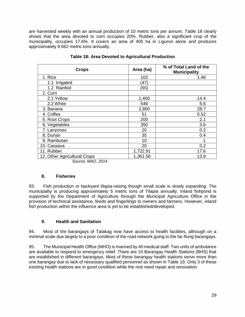
29
are harvested weekly with an annual production of 10 metric tons per annum. Table 18 clearly shows that the area devoted to corn occupies 20%. Rubber, also a significant crop of the municipality, occupies 17.6%. It covers an area of 405 ha in Liguron alone and produces approximately 8.662 metric tons annually.
Table 18: Area Devoted to Agricultural Production
Crops Area (ha) % of Total Land of the
Municipality
1. Rice 102 1.46
1.1 Irrigated (47)
1.2 Rainfed (55)
2. Corn
2.1 Yellow 1,400 14.4
2.2 White 546 5.6
3. Banana 2,800 28.7
4. Coffee 51 0.52
5. Root Crops 200 2.1
6. Vegetables 350 3.6
7. Lanzones 20 0.2
8. Durian 35 0.4
9. Rambutan 10 1
10. Cassava 20 0.2
11. Rubber 1,722.91 17.6
12. Other Agricultural Crops 1,361.56 13.9 Source: MAO, 2014
8. Fisheries
93. Fish production or backyard tilapia-raising though small scale is slowly expanding. The municipality is producing approximately 5 metric tons of Tilapia annually. Inland fishpond is supported by the Department of Agriculture through the Municipal Agriculture Office in the provision of technical assistance, feeds and fingerlings to owners and farmers. However, inland fish production within the influence area is yet to be established/developed.
9. Health and Sanitation
94. Most of the barangays of Talakag now have access to health facilities, although on a minimal scale due largely to a poor condition of the road network going to the far-flung barangays. 95. The Municipal Health Office (MHO) is manned by 40 medical staff. Two units of ambulance are available to respond to emergency relief. There are 10 Barangay Health Stations (BHS) that are established in different barangays. Most of these barangay health stations serve more than one barangay due to lack of necessary qualified personnel as shown in Table 19. Only 3 of these existing health stations are in good condition while the rest need repair and renovation.

30
Table 19: Existing Barangay Health Stations
Base of BHS No. of Rural Health
Midwives No. of Barangays
Served Current Condition
1. San Isidro 1 1 Needs Repair
2. Sa Antonio 1 2 Good
3. Sto. Nino 1 3 Undergoing Const. of New Building
4. Liguron 1 3 Needs Renovation
5. Cosina 1 3 Good
6. Indulang 1 3 Good
7. Dominorog 1 1 Needs Renovation
8. Tagbak 1 3 Undergoing Renovation
9. Miarayon 1 3 Needs Renovation
10. Tikalaan 1 2 Needs Renovation Source: Talakag SEP, 2014
10. Tourism and Recreation
96. The municipality of Talakag is gifted with a natural beauty of scenic mountains, enthralling waterfalls and beautiful plantations. The municipality has identified several potential tourist spots. These areas are still underdeveloped and its access roads still need consideration. Table 20 includes the existing and potential tourist spots in the municipality.
Table 20: Tourist Attractions by Municipality
Tourist Attraction Specific Location Status
Municipality of Talakag
Minda Mora Falls SitioBitaog, Lantud Accessible
Tikalaan Falls Tikalaan Accessible
Miarayon Region Miarayon Accessible
Durian Peace Treaty Site Tikalaan Accessible
Sagayon Canyon Inside Mt. Kalatungan Accessible
Balaon Canyon San Isidro Accessible
Cagayan River Across the Municipality Accessible
Kiarig Falls San Antonio Accessible
Lantud Bat Cave Lantud Accessible
Bulao Cold Spring San Isidro Accessible
Wanggilan Lagoon San Antonio Accessible
Golden Hills Tagbak Accessible Source: Municipal/City CLUP

31
11. Access to Safer Water and Electricity
97. Access to water supply within the river basin is important as it provides the households their drinking water, water for agriculture, and household uses. The Municipality of Baungon has more households with access to potable water while Talakag has the least with only 47%. Access to safe-water may avoid water-borne diseases and minimize other health problems (Table 21).
Table 21: Household Access to Potable Water
Households with Access to Potable Water
Municipality Number of
Households % Households
Talakag 5,175 46.97%
Baungon 5,949 93%
Libona 5,272 83.04%
Source: City/Municipality CLUP
98. In 2013, the municipality of Libona determined 7,049 households served by electricity. On the other hand, unserved households in Talakag and Baungon are greater than served households (Table 22).
Table 22: Households Served and Unserved by Electricity Households Served and Unserved by Electricity
TALAKAG (2008)
Number of Households
Served 4,452
Unserved 7,762
BAUNGON (2008)
Served 3,997
LIBONA (2013)
Served 7,049
Unserved 2,617 Source: City/Municipality CLUP
12. Communication
99. In terms of communication, a lot of facilities and services are available in the municipalities most significantly in the urban and urbanizing areas. Access to Internet is now trouble-free with the entry of Globe and SMART providers. Thus, cellular phones are the most common tool for communication. Postal service office is also present in each Poblacion manned by a post master and the letter carrier. Due to modern technology, there is an observed downward trend of inflow and outflow of mails and letters. Table below shows the summarized list of communication facilities.
32
13. Road Access and Transportation
100. Access and mobility are restricted in the watershed areas, especially during the wet season when many roads become impassable for motorized traffic. Improved access reduces costs of transactions, facilitates business and investment, and improves connectivity to health and social service providers. 101. Cagayan de Oro City, being the center of trade and commerce in Northern Mindanao, provides good transportation facilities to the neighboring regions. Laguindingan airport is approximately 40 kilometers from the city which has flights to nearby cities like Cebu, Davao and Manila. Aside from the Port of Cagayan de Oro, several private ports are also present namely, Cagayan de Oro Oil Mill, Cagayan Corn Products, Corp., Del Monte Phils., Inc., General Milling Corporation, and Carlos A. Gothong Inc. Cagayan de Oro City is the nearest city from the municipalities of Talakag, with the distances of 36 kilometers. The common public transportation vehicles are jeepneys, public vans and single motors commonly called habal-habal. 102. Based on the municipal CLUP of Talakag, there are a total of 106 public land transportation vehicles. 52 units of these PUJ cover the urban areas of the municipality. Vehicles such as jeepneys, vans, motorelas, tricycles, and cargo trucks rove around. In rural areas, animals such as horses, cows and carabaos are still used as means of transportation to move goods from one barangay to another.
V. ANTICIPATED ENVIRONMENTAL IMPACTS AND MITIGATION MEASURES
103. The IEE, based on the screening of baseline environment and review of proposed civil works, has not identified any major environmental concerns due to proposed rehabilitation and improvement of Liguron access road given that all the proposed civil works are only asset preservation of existing roadway and are located within existing right of way. There will only be localized short-term impacts during construction activities due to implementation of civil works that will be addressed in the detailed design and through implementation of the mitigation and monitoring measures specified in the environmental management plan. These construction related impacts can be mitigated by 1) the contractors’ work practices, especially those related to the systematized demolition procedure consistent with approved standard safety requirements; 2) cooperation by the local authorities with the contractor in terms of use of public space and utilities; 3) project management’s strict enforcement of the correct construction practices and standards; 4) the incorporation of the mitigation measures identified in the IEE into the bid documents and specifications; and 5) close monitoring of the contractor’s implementation of the required mitigation measures. 104. The potential environmental impacts resulting from implementation of civil works are expected to be minor and likely short-term since the improvement works will not involve widening and alignment adjustments (Table 23). Detailed environmental mitigation measures have been prepared for all the identified impacts and presented in the environmental management plan under Chapter VIII.

33
Table 23: Assessment of Potential Environmental Impacts
Potential Environmental Impacts or Values the Subproject construction would likely create:
Excavati
on
/
Str
uctu
re
Excavati
on
A
gg
reg
ate
Base C
ou
rse
Su
b-g
rad
e
Pre
pa
rati
on
Co
nc
rete
Pavem
en
t
Str
uctu
ral
Co
nc
rete
Pip
e C
ulv
ert
an
d
Sto
rm D
rain
s
Gro
ute
d R
ipra
p
Land surface disturbance – surface scrapping, top soil erosion, and vegetative clearing
moderate minor minor minor minor minor minor
Affects temporal water regime: decrease water quantity and quality and flow regularity or seasonality due to altered drainage patterns, water way configuration, sedimentation, turbidity, as well as river flow diversion
minor minor minor minor minor minor minor
Altered or impaired hydrology of the immediate area: increase peak and flood flows and irregular streamflow
minor minor minor minor minor minor minor
Decrease in downstream natural resources’ economic and social values/uses
minor minor minor minor minor minor minor
Decrease site’s attraction in terms of losing some geological or geomorphological values, particularly those of known local, national or international nature conservation importance
minor minor minor minor minor minor minor
Vegetation loss affecting rare species habitats, particularly of known local, national or international nature conservation importance
minor none none none none none none
Adverse impact on local and transient fauna species (those species whose range may include the project site), particularly those of known local, national or international nature conservation importance.
minor none none none none none none
Bio-invasion of new strain of pests, weeds or rare diseases
none none none none none none none
Frequent incurrence and increased intensity of grassfire
none none none none none none none
Contamination of the immediate and/or broader environment cause by the storage or use of chemicals needed for the construction works
minor minor minor minor none none none
Air particulate emissions which may cause atmospheric / environmental pollution impacting on human health and livelihood at local or larger scale during construction phase
moderate moderate moderate moderate moderat
e minor minor
Excessive solid waste accumulation during infrastructure construction
minor minor minor minor minor minor minor
Increase in noise and/or vibration during construction
minor minor minor minor minor minor minor
Unnatural lighting effects that may impact upon flora and fauna, or deplete the sense of naturalness of the area
none none none none none none none
Natural landscape fragmentation and discontinuity
none none none none none none none
Adverse impact on land use and the amenity values of adjacent or downstream areas (including the integrity of agricultural land, or other industry that the local community may depend on)
minor minor minor minor minor minor minor
Adverse impact on existing or potential recreational value and quality of known traditional experience associated to site natural setting
minor minor minor minor minor minor minor
Adverse impact or alter on-sites’ visual value and its surrounding area -from different vantage points
minor minor minor minor minor minor minor
Rating: None= no adverse impact; Minor= slight negative impact and momentary; Moderate=slight negative impact for a year but not damaging enough to cause ecological, health and economic disturbance.

34
105. During operation, the project is expected to benefit the environment and socio- economic conditions of the subproject areas through increased delivery of agricultural products, increased tourism, improved access and economic development, reduced dust due to asset preservation, improved road safety due to installation of safety signs, and others. 106. Environmental impacts and proposed mitigation measures during subproject pre-construction, construction and operation phases are described under Chapter VIII. Detailed environmental mitigation measures have been prepared for all the identified impacts and presented in the environmental management plan. A. Pre-Construction
1. Confirmation of no required resettlement, relocations, and compensation
107. This will be undertaken prior to the commencement of any civil works. The proponent shall conduct consultation meetings with directly affected barangays and concerned POs’, and information awareness campaign regarding subproject location.
2. Identification and prioritization of road section where re-gravelling will be done
108. Identification and prioritization of road sections will be give information and participation of the community, particularly women and marginalized sectors. A subproject site validation will be facilitated to ensure that the INREMP validation process on subproject implementation is being complied with and hold consultative meetings with balanced representation of men and women and affected persons on the subproject components and management plan.
3. Preparation of detailed engineering designs and programs of work
109. The detailed engineering designs and programs of work for the subproject will be prepared by the LGU for the completion of the proposed upgraded access road. The detailed designs shall include the identification of spill management prevention and emergency response plans for all construction sites, locate aggregate borrow pits and rock supply areas away from human settlements with fencing and access barriers, and specific plan to notify and provide them schedule to minimize disruption to normal commercial and residential activities. 110. The LGU with assistance from TA-PMIC will ensure that relevant provisions of the EMP in terms of implementation of environmental mitigation measures, monitoring activities, supervision and reporting are included for civil works and construction supervision.
4. Recruitment of workers
111. The potential impact of the subproject will be hiring of skilled local workers and other unskilled jobs. A robust “local first” hiring policy will be designed and be implemented in coordination with local officials and community leaders especially at the barangay and municipal levels. The Contractor will be required to follow the “local first” hiring policy.

35
B. Construction
1. Construction materials acquisition, transport access, and storage system
112. The contractors will source construction materials under their own arrangements. Uncontrolled sourcing of such materials could lead to environmental impacts such as the loss of topsoil or the disfigurements of the landscape from borrow pits. Earthen embankments and material stockpiles will be susceptible to erosion, particularly during the rains and re-suspension of dust during the dry seasons. 113. Local roads will be damaged during transportation of borrow materials and by the construction equipment. These roads include those which are leading to the project site. In order to reduce impact on all borrow sites, contractors will water the local roads close to the settlements used by the borrow trucks. As much as possible, contractors will not make use of productive agricultural land. In case this is unavoidable, the contractor will obtain consent from the land owner and will restore the site to its original condition after completion of civil works.
2. Clearing and removal of obstructions
114. The contractor will initiate clearing and removal of obstructions on the existing road which would result to have minor damage landscape. Affected trees will be removed during site preparation and ground clearing. Again, the DENR-CENRO Talakag issued a certification, dated April 28, 2017, regarding the request of the LGU Talakag for the cutting of affected trees along easement of the road that needs to be cut. The CENRO is currently verifying the submitted documents and eventually conducting actual inspection and inventory of the affected trees. 115. There are no encroachments of any residential houses or dwellings, businesses, or institutional structures found along the right of way of the proposed rehabilitation of access road. There are no house/ dwelling structures found on these areas other than fences made of light indigenous materials, mostly of bamboo sticks. The owners have waived their right to any claim and/ or compensation as evidenced in the signed waivers. 116. The contractor will not use or permit the use of wood as a fuel for the execution of any part of the works, including but not limited to the extent practicable shall ensure that fuels other than wood are used for cooking.
3. Soil erosion
117. Soil erosion and unstable side slopes susceptible to landslides are noticed along subproject road. The impact of soil erosion and unstable side slope are increased run off and sedimentation causing a greater flood hazard to the downstream, loss of topsoil affects the growth of vegetation that causes ecological imbalances, and development of unsightly cuts and fills that have been riddled by uncontrolled erosion and gullying. Construction activities should be taken up only during dry season. 118. During operation, silt load in the river is expected to be minor due to slope protection structures installed. The contractor will also be required to make additional measures to minimize erosion and landslides during construction phase such as 1) minimize damage and cutting of

36
surrounding vegetation during slope formation, 2) prevent erosion and protect the cut slope with temporary drainage as soon as practicable after cutting, and 3) If new erosion occurs accidentally, back fill immediately to restore original contours.
4. Ground surface leveling and gravelling of existing road
119. During ground surface leveling and gravelling of existing road, the potential impacts would be minor and short-termed to the terrestrial resources as well as to the quality of surface water in the river. The contractor will be required to do the following: 1) the construction site should be located away from forested or plantation areas, 2) all construction fluids such as oils, and fuels should be stored and handled away from forested and plantation areas, 3) no waste of any kind is to be discarded on land or in forests/plantations, 4) erosion channels must be built around aggregate stockpile areas to contain rain-induced erosion, 5) earthworks should be conducted during dry periods, 6) no waste of any kind is to be thrown in surface waters, 7) no washing or repair of machinery near surface waters, 8) pit latrines to be located away from surface waters, 9) no unnecessary earthworks in or adjacent to water courses, 10) no aggregate mining from rivers or lakes, and 11) minimize the use of heavy equipment at steep slopes.
5. Civil works
120. Since the subproject will mainly involve concrete pavement (with no road widening and realignments), main impacts on land during construction are from air pollution, land and water contamination, and traffic and access problems. The contractor will apply stated mitigating measures during concrete pavement and stone masonry activities such as 1) piling of aggregates at sites should be used/or removed promptly, or covered and placed in non-traffic areas, and 2) all spills should be cleaned immediately and handled as per hazardous waste management plan, and according to government regulations.
6. Implementation of noise and dust control measure
121. During construction, air quality is likely to be degraded by exhaust emissions from the operation of construction equipment, and dust generated from haul roads, unpaved roads, exposed soils and material stock piles. 122. In order to mitigate these, the following will be implemented: 1) regularly apply wetting agents to exposed soil and construction roads, 2) cover or keep moist all stockpiles of construction aggregates, and all truckloads of aggregates, 3) minimize the time for excavations and exposed soil are left open or exposed, 4) backfill immediately after work is completed, 5) restrict working time between 7:00 am and 5:00 pm, 6) maintain equipment in proper working condition, 7) replace unnecessarily noisy vehicles and machinery, 8) vehicles and machinery to be turned off when not in use, and 9) construct temporary noise barriers around excessively noisy activity areas if possible.
7. Dust and noise from borrow pits
123. Noise and dust may be generated from borrow pits. The contractor will ensure the following mitigating measures: 1) provision of noise control measures to comply with national
37
standards, watering of the earth roads close to the settlements, use covered truck, 2) secure appropriate environmental permits, 3) the borrow and material dumping sites must be access controlled to keep away unauthorized entry of people, grazing cattle and any other stray animals, and 4) protective gear like ear plugs will be provided to operating personnel if they are exposed to noise levels beyond threshold limits.
8. Implementation of spoil management and control measure
124. The contractor will ensure that there will be no contamination of land and surface waters from excavated spoils, and construction wastes. The uncontaminated spoils will be disposed of in municipal or provincial designated sites, which must never be in or adjacent surface water. On the other hand, suspicious contaminated soil will be tested, and disposed of in designated sites identified as per government regulations.
9. Solid and liquid construction waste management system
125. Solid and liquid construction wastes management system will be facilitated to avoid contamination of land and surface water from the construction wastes. The management of general solid and liquid wastes of construction will follow government regulations to include covering, collecting, handling, transporting, recycling, and disposing waste created from construction activities and the work force. A schedule of solid and liquid waste pickup and disposal will be established and followed to ensure construction sites are as clean as possible. All solid wastes will be separated and recyclables be donated to the barangay. There will be no site-specific landfills established by the contractors. All solid waste will be collected and removed from the work camps and disposed in local waste disposal sites.
10. Water quality
126. The subproject has potential impacts on water quality due to washing of equipment (i.e. vehicles and concrete mixers), and leakage and spills from discharge from worker camps to the water resources. To mitigate, there should be a 1) set up proper and adequate sanitary facilities, 2) ensure strict observance of proper waste handling and disposal and proper sanitation including by the contractors and its workers, 3) provide wastewater treatment facility (e.g., septic tank), and 4) trucks and other vehicle maintenance should be strictly controlled to prevent the discharge of waste into the river system. Wastewater from the construction works containing high concentration of suspended solids should be treated through sedimentation tanks.
11. Construction drainage system
127. The contractor shall construct drainage systems to facilitate drainage and rain water natural channels. The contractor will also provide adequate short-term drainage away from construction sites to prevent ponding and flooding.

38
12. Workers health, safety and hygiene
128. Construction sites are likely to have public health impacts. Contractors will ensure that no untreated wastewater is discharged in the river and that no site-specific landfills will be established at the construction camps. There will be a potential for diseases to be transmitted, exacerbated by inadequate health and safety practices. The contractor will therefore be required to recruit or designate a health and safety officer to address such concerns in the work sites and liaise/work with the nearby communities. 129. Mitigation measures include: 1) proper fencing, protective barriers, and buffer zones should be provided around all construction sites, 2) sufficient signage and information disclosure, and supervisors and night guards should be placed, 3) worker and public safety guidelines should be followed, 4) provide adequate sanitation and waste disposal at construction sites, 5) the contractor will not hire children and pregnant women, 6) standing water suitable for disease vector breeding should be filled in, 7) worker education and awareness seminars for construction hazards should be given at the beginning of the construction phase. A construction site safety program should be developed and distributed to workers, 8) appropriate safety clothing, footwear, gloves, hard hats, eye protection and other PPE should be mandatory for all construction workers, 9) adequate medical services must be on site or nearby all construction site, 10) drinking water must be provided at all construction sites, 11) sufficient lighting be used during necessary night work, and 12) all construction sites should be examined daily to ensure unsafe conditions are removed.
13. Traffic safety and management
130. Throughout the construction period, the contractor should ensure that affected people are provided adequate and safe access to properties (structures, land, etc.). The contractor is responsible for ensuring that all construction vehicles observe speed limits on the construction sites and to provide adequate signage, barriers, and flag persons for traffic control. Sign postings such as ‘men working’, ‘Keep left/right’, ‘construction ahead’, and ‘speed limit’, should be used for traffic management and road safety. As much as possible, road works will be confined to one half of the road width at each section to provide access to pedestrian and vehicles during construction works.
14. Ecological environment (Flora and Fauna)
131. Access road rehabilitation work will directly cause minor degradation of the local ecology through the clearance of small areas of vegetation (mainly ipil-ipil and coconut) at major work sites. A short-term impact on ecology along the rehabilitated road is likely to occur in worksites during the construction period due to minor vegetation clearance. Vegetative cover stripped from the locations described above will be kept for slope protection. 132. Meanwhile, the potential impacts from construction worker camps are poaching of edible animals and birds of the locality in spite of prohibitions. The contractors’ will be responsible for providing adequate knowledge to the workers regarding the protection of fauna. In short, all workers will be prohibited from hunting wild animals.

39
15. Damaged to properties
133. Another potential impact during construction is damaged to properties (structures, irrigation, farmland) and access roads due to civil works, transport of materials and other project-related activities. To address this impact, the contractor will immediately repair and/or compensate for any damage that it causes to properties (houses, farmlands, aquaculture ponds, irrigation canals, and others), community facilities such as water supply, power supply, communication facilities and the like. Access roads used for transport of construction materials and other construction-related activities will be maintained by the Contractor in at least in their pre-project condition for the duration of construction.
16. Concrete washout
134. The discharge of cement-laden water and slurry during concrete mixing may contaminate water resources and damage productive land in the surrounding areas. To mitigate possible effects of cement-laden water and slurry, the Contractor shall 1) collect and retain all the concrete washout water and solids in leak proof containers, so that this does not reach the soil surface and then migrate to surface waters or into the ground water, 2) recycle the collected concrete washout water and solids, and/or 3) use of a washout pit made with a plastic lining that can be dug into the ground or built above grade.
17. Use of Hazardous Substances
135. Storage and use of fuel, lubricant and other toxic and hazardous chemicals will have potential impacts on soil surface and groundwater contamination. To address this impact, vehicle maintenance and refueling will be confined to areas in construction sites designed (with concrete flooring, drainage leading to oil and water separator, etc.) to contain spilled lubricants and fuels. Spill waste will be disposed to sites approved by the concerned government agency and following national regulations. Adequate precaution will be taken to prevent oil/lubricant/ hazardous substances contamination of channel beds. Spillage if any will be immediately cleared with utmost caution to leave no traces. All areas intended for storage of hazardous materials will be quarantined and provided with adequate facilities to combat emergency situations such as fire, spills, etc. in compliance with all the applicable statutory stipulation. The personnel in-charge of these sites will be properly trained and these areas will be access controlled and entry will be allowed only under authorization. Hazardous wastes will be collected, stored, transported and disposed consistent with national regulations to ensure that these will not cause pollution of surrounding areas.
18. Public safety
136. `Some of the mitigation measures that should be implemented are as follows: To mitigate this impact, the following should be addressed by the Contractor: 1) installation of sturdy fencing around excavation areas and construction sites, 2) provision of proper signage and lighting at night at the periphery of the construction site to warn and direct traffic and pedestrians, 3) deployment of security personnel in hazardous areas to restrict public access, 4) imposition of speed limits for construction vehicles along residential areas and where there are other sensitive receptors, and 5) orientation of drivers on safe driving practices to minimize accidents and to prevent spill of hazardous substances and other construction materials during transport.

40
C. Operation and Maintenance (O&M) Phase
1. Operation of upgraded access road
137. The operation of the Rehabilitation and Improvement of Liguron Access Road will have potentials impacts both positive and negative to the area. The negative impacts will directly involve the increased risk of accident or injury, air pollution and noise, and unplanned urbanization. However, the positive impacts will mainly focus on increased delivery of agricultural products, provide access to natural resources management project sites, and open for tourism businesses. To mitigate these impacts, the LGU of Talakag and other concerned agencies shall initiate and implement the following: 1) set speed limit when passing through populated area, 2) provide appropriate warning signs and lighting, 3) regular removal of debris, logs and other materials along drainage canals to avoid clogging, 4) regular vegetation control along run-off area to ensure free flow, 5) ensure that existing environmental management policies are effectively implemented and proper coordination involves different agencies, 6) adherence to land use and zoning regulations, and 7) promote tourism in the area through advertisement from the local and nationwide venue.
VI. INFORMATION DISCLOSURE, CONSULTATION, AND PARTICIPATION
A. Stakeholder Consultations
138. The IEE process included stakeholder participation and consultation to help LGUs achieve public acceptance of the Subproject. The proposed project will involve the participation of the local community in the project influence area where better access to basic services will be enjoyed, more economic opportunities can be availed of, and their living conditions will be improved. 139. The main beneficiaries of the subproject are the farmers at Barangay Liguron, and the partner PO which is the LIDASAFA which is mainly composed of IPs, since they are the major users of the road for the transport of their farm products and access to the NRM sites to enhance their NRM activities and projects. Other beneficiaries will be the community within Barangay Liguron particularly along the Sitio of Limonsod. They will have ease of access and transport going to schools, municipal hall, health center, etc., and will also save them time and transportation cost. As a result, the Barangay Officials and the LIDASAFA issued Resolutions of Support as a manifestation of their support and no objection to the proposed subproject on March 28, 2017 and April 25, 2017, respectively (Appendices 2 and 3) 140. On April 25, 2017, the Sangguniang Bayan of Talakag issued a resolution reaffirming the interest of the local government unit of Talakag and authorizing the chief executive to apply, negotiate, avail grant financing from the INREMP of the DENR thru municipal development fund office, and undertake other acts necessary to effect implementation of the rehabilitation and improvement of Liguron access road (Appendix 4). 141. For Indigenous Peoples, a consultation meeting with the Liguron Tribal Council, the LGU and the INREMP personnel was held in Liguron last May 24, 2017 (Appendix 5). During the

41
forum, the proposed subproject was thoroughly discussed by all concerned parties and they resolved that the Rehabilitation and Improvement of Liguron Access Road is within an existing ancestral domain claim taking into account that there is a pending CADT application in the NCIP. No IPs residing within the influence area will be adversely affected by the proposed project. A resolution of consent (Appendix 3) was then passed and approved by the Liguron Tribal Council to manifest their overwhelming support to the RI Subproject. 142. Another public consultation was conducted on July 17, 2017 by the proponent with technical assistance of consultant which they presented the subproject description, proposed civil works, and anticipated environmental impacts and their mitigation measures (Appendix 6). The consultations went very well and effective and the discussions were documented. The results of the consultation were positive, with local people considering that the road will bring significant economic benefits to the barangays and increase trade flows. Concerns on the subproject mainly revolved on its construction phase which can be mitigated. No long term negative environmental impact assessed by the participants. Majority of the respondents cited ease of transport as one of the direct benefits of the road; majority of them as well are not anticipating any negative impact of the subproject to the environment though one of the respondents mentioned that the road might be a corridor for illegal loggers to access the forest land so he suggested an intensified barangay patrolling during the operation phase of the access road. 143. At the end of the meeting, the participants were given questionnaires to express their views and concerns of the subproject. Details of the consultations and issues raised during these consultations are given in Table 24. 144. With the involvement of the LGU in the subproject activities of INREMP particularly in the implementation of rural infrastructure support facilities, they dedicated time and effort in participating with orientation, consultation, planning and training activities. Indeed, a municipal resolution was crafted affirming the interest of the local government unit to apply, negotiate, avail financing grant from the INREMP of the DENR thru the municipal development fund office, and undertake other acts necessary for the effective implementation of the proposed subproject.
Table 24: Summary of Stakeholder Views of the Road Rehabilitation and Improvement in Talakag
Date: July 17, 2017
Venue: Barangay Hall, Liguron, Talakag
Number of Participants: 66
Participating agencies/institutions: POs, local residents, LGU
Questions Responses
Benefits from the road rehabilitation expressed by on-site and off-site stakeholders
The following are the responses of the participants when asked what benefits they’re expecting to gain from the subproject:
In case of forest fires, fire responders could easily reach the area and put off the fire
Ease of product transport from farm to market, the subproject road will serve as a shortcut thus minimizing delivery travel time of goods
Save in Transportation Cost
Monitoring of forest resources would be easier. BLGU committed to be stricter with environment and natural resources protection initiatives.
Beneficiaries Response Project Management Team Response

42
Table 24: Summary of Stakeholder Views of the Road Rehabilitation and Improvement in Talakag
Date: July 17, 2017
Venue: Barangay Hall, Liguron, Talakag
Number of Participants: 66
Participating agencies/institutions: POs, local residents, LGU
Questions Responses
Pre- construction phase issues
No issues were identified in this phase (Findings: Pre-construction phase)
No issues were identified in this phase
Construction phase issues
The contractor may accidentally spill diesel in nearby lots while refueling their heavy vehicles.
The contractor embanking the excavated soil anywhere by the road.
Concrete/ cement improper handling
Contractor washing their equipment on the nearby water surface.
PO Suggestion/s:
BLGU and MLGU to request to the contractor to properly dispose waste, preferably outside the barangay. In addition, BLGU and POs to put up signage for proper waste disposal
Request the contractor, whoever it may be, to excavate slowly and cautiously and embank the soil immediately to road sections that need to be filled.
POs should take the initiative to put up canals alongside the road so that runoff from the road construction will not directly go to the rice fields
PO and BLGU would ensure that the contractor will not mix cement near the ricefield and/or the water surface nearby. Contractor should be advised to have their own mixing board. Contractor should also be advised to concrete one line at a time so as not to hinder transport of goods and services
Facilitator’s Suggestion/s:
Engr. Tingson also suggested that PO members should remain watchful during the course of subproject implementation.
Reinforce signage on proper cleaning of materials, equipment
Operation and maintenance phase issues
Improper waste disposal on the road as there will be increase of people passing by
Possible increase of vehicles utilizing the road, that may result to incidence because vehicle riders may increase their speed since the road
PO member suggested that maintenance activities should be regularly conducted. Canals should also be cleaned regularly
Another PO member suggested that road safety signs such as speed limits should be put up along the road.

43
Table 24: Summary of Stakeholder Views of the Road Rehabilitation and Improvement in Talakag
Date: July 17, 2017
Venue: Barangay Hall, Liguron, Talakag
Number of Participants: 66
Participating agencies/institutions: POs, local residents, LGU
Questions Responses
would already be in a good condition.
Improved condition of road provides opportunity for illegal loggers to access forestry resources
A barangay kagawad said that BLGU should allot budget for maintenance of road.
Plant trees along the road to provide shade
Barangay to monitor activities within its jurisdiction which is easier because of improved road facility.
Facilitator’s Suggestion/s:
Engr. Tingson suggested that each PO should be responsible of cleaning the canals.
Suggested impact mitigation measures
Aside from the anticipated issues and its corresponding mitigations/ responses mentioned on the previous table, the TA-PMIC also identified potential issues and mitigation measures that the subproject might face. These issues and measures are all captured on the Environmental Impact Mitigation Plan of Talakag.
B. Information Disclosure
145. After study completion, the IEE documenting the mitigation measures and consultation process will be submitted to ADB for posting on their website, DENR-FMB, the Municipality of Talakag, Bukidnon and the affected Barangay office, the Provincial Environmental and Natural Resource Officer, and DENR regional office, which will make them available to the public. More informal and vigorous level of disclosure and consultation will be done during implementation through:
• The preparation and dissemination of a brochure in local languages, explaining the affected peoples’ entitlements and the procedures for obtaining compensation for temporary disturbances, trees, crops, and land for construction camps and recording grievances; and
• Setting up a formal grievance redress committee with a representation from the affected people. Field consultant in association with the Contractor will be responsible for managing the effective grievance redress program.

44
VII. GRIEVANCE REDRESS MECHANISM
146. The Local Government Unit of Talakag has properly conducted the consultations with the different stakeholders of the sub-project site. However, it still has to make room for possible issues, concerns, or grievances and disputes arising from the communities in relation to the project implementation. Thus, it sets up a Grievance Redress Mechanism to provide a venue for resolving grievances and disputes even at the lowest level. This will be done to resolve disputes as early and as quickly as possible before it escalates to an unmanageable level.
147. Since, the community consultations were conducted smoothly and no adverse or violent reactions have been noted, there are only minor grievances that are anticipated which may arise due to the project implementation, which are listed below:
a. Road accessibility related grievances – This may include complaints from communities
using the roads under repair or construction due to temporary obstruction, which may cause delay in travel time and other inconveniences of the travelling public.
b. Construction related grievances – Community members may demand to be hired as part of the labor force in the project construction/implementation. This may also include complaints of community members regarding noise, drainage, and etc.
c. Indigenous Peoples related grievances – may come from IPs residing within the influence areas concerned with potential effects to ecological and social resources of their area/abode.
148. If case grievances and disputes do arise, there are existing groups in the area which can be tapped to form part of the GRM. In fact, different active groups exist in the area such as the Barangay Development Council (BDC) with its Lupon which is mainly in-charge of settling disputes related to barangay administration, and the IP Chieftain and IP Mandatory Representative, which also takes care of resolving disputes relating to the indigenous people residing in the Barangay Liguron. 149. A subproject-specific grievance redress mechanism will be established at the PPCO to receive, evaluate and facilitate the complaints/grievances of affected persons on the sub-project’s environmental performance. This mechanism will be disclosed to the host communities before start of civil works. 150. The grievance redress committee (GRC) will be chaired by the PPCO head. Members will include the following: (i) designated GRM officer of PPCO, (ii) contractor’s highest official at the site such as the Construction Manager or the Construction Superintendent; and (iii) barangay chairperson. For the quick filing of complaints, the GRC will use the attached grievance intake form (Appendix 7). The PPCO's GRM officer will be responsible for registration of grievances and communication with the aggrieved party. 151. The steps to be followed in filing complaints and the procedures for redress are the following:
(i) complainant will provide the background and file the complaint verbally or in writing to the PPCO, and the PPCO's GRM officer will assist the complainant in filling-up the

45
grievance intake form; (ii) within 2 working days, the GRM Officer, contractor’s representative, and
complainant will discuss if the complaint can be resolved without calling for a GRC meeting;
(iii) within 3 days of lodging the complaint, the PPCO's GRM officer will provide the complainant a written feedback on the process, steps and timeframe for resolving the complaint.
(iv) if the complaint cannot be resolved, a GRC meeting with the complainant will be called within 5 working days;
(v) the GRC will have 15 working days to resolve the complaint; (vi) the complainant will receive feedback from the PPCO's GRM officer within 5 working
days after the various steps of the GRM are completed; and (vii) if unsatisfied with the decision, the existence of the GRC will not impede the
complainant's access to the Government's judicial, administrative remedies or through concerned government agencies (e.g., Community Environment and Natural Resources Office and Provincial Environment and Natural Resources Office of DENR, Regional offices of the Environmental Management Bureau, etc.)
151. The GRC will receive, follow-up and prepare monthly reports regarding all complaints, disputes or questions received about the Project and corresponding actions taken to resolve the issues. These reports will be included in the semi-annual environmental monitoring reports to be submitted to ADB. Grievance Among IPs
152. Giving primacy to the traditional conflict resolution system, grievances will be handled following the procedure outlined below. In resolving disputes among the indigenous peoples, the determination or decision is usually reached through dialogue and consensus. There may be several conflict resolution sessions according to the specific tribe’s customary laws before the dispute may be resolve. Thus, there is no clear definite timeline on when the conflict or dispute should be settled at the level of the clan and the Council of Elders.
a. Dispute/grievance will be resolved first among the members of the clan; b. If the said grievance/dispute is not resolved at the clan level, this will be brought to the
level of the Council of Elders (COE); and c. If still unresolved at the COE level, the said dispute/grievance will be submitted to the
NCIP Regional Hearing Officer (RHO), for resolution, where the decision will be final and executory. The dispute/ grievance will be heard and adjudicated in accordance with the Rules on Pleadings, Practice and Procedures before the NCIP.

46
VIII. ENVIRONMENTAL MANAGEMENT PLAN
A. Implementation Arrangements
154. Institutions responsible for executing and monitoring the implementation of the EMP are presented in Table 25.
Table 25: Responsibilities for EMP Implementation Agency Responsibilities
LGU of Talakag, Bukidnon Executing agency with overall responsibility for project construction and operation
Ensure that sufficient funds are available to properly implement the EMP
Ensure that Project implementation complies with Government environmental policies and regulations
Ensure that the Project, regardless of financing source, complies with the provisions of the EMP and ADB Safeguard Policy Statement 2009
Obtain necessary environmental approval(s) from the Environmental Management Bureau and/or other concerned government agencies prior to commencement of civil works
Ensure that tender and contract documents for design, supervision and civil works include the relevant EMP requirements
Establish an environmental grievance redress mechanism, as described in the IEE, to receive and facilitate resolution of affected peoples’ concerns
Submit semi-annual monitoring reports on EMP implementation to ADB.
Existing ADB Project Management Office
Project management office with direct responsibility for the implementation of civil works, engineering designs and project coordination.
Ensure that EMP design measures are incorporated in the detailed design
Ensure that EMP provisions are strictly implemented and monitored during various project phases (design/pre-construction, construction and operation) to mitigate environmental impacts to acceptable levels
Include relevant provisions of the EMP in the bid and contract documents for design, civil works and supervision.
PPMO and WMPCO Closely monitor contractor’s environmental performance and over-all implementation of the EMP
Prepare semi-annual environmental monitoring reports on status of EMP implementation for submission to ADB
Based on the results of EMP monitoring, identify environmental corrective actions and prepare a corrective action plan, as necessary, for submission to ADB
Responsible for coordinating with EMB, Local Government Units (LGU), and other concerned agencies related to environmental aspects for maintaining project`s compliance with environmental permits.

47
Table 25: Responsibilities for EMP Implementation Agency Responsibilities
TA – PMIC and NPCO Engage environment specialists who will undertake supervision and monitoring of EMP implementation and contractor’s environmental performance
As part of day-to-day project supervision, closely supervise and monitor the contractor’s implementation of mitigation measures specified in the EMP
Assist PMU and WMPCO in preparing semi-annual environmental monitoring reports on status of EMP implementation. Such report will include results of ambient environmental monitoring to be conducted by the contractors.
Contractors Recruit qualified environmental and safety officer to ensure compliance with environmental statutory requirements, contractual obligations and EMP provisions
Provide sufficient funding and human resources for proper and timely implementation of required mitigation and monitoring measures in the EMP
Implement additional environmental mitigation measures, as necessary, to avoid, minimize and/or compensate for adverse impacts due to construction works and related activities performed by the contractor.
EMB – DENR Review and approve environmental assessment reports required by the Government
Undertake monitoring of the project’s environmental performance based on their mandate
ADB Conduct periodic site visits to assess status of EMP implementation and over-all environmental performance of the Project
Review environmental monitoring reports submitted by the executing agency to ensure that adverse impacts and risks are properly addressed
Publicly disclose through posting on ADB’s website environmental monitoring reports, corrective action plans, new or updated IEE (if any) prepared by the executing agency during project implementation

48
B. Environmental Mitigation
155. Table 26 presents environmental mitigation measures to address anticipated adverse impacts of the Subproject. The EMP also shows responsibilities for implementation of mitigation measures and corresponding supervision and monitoring.
Table 26: Environmental Impact Mitigation Plan Project
Component/Activity Potential
Environmental Impacts
Mitigation Measures Institutional Responsibilities Cost Estimates
Implementation Monitor
Pre-Construction Phase
1. Confirmation of no required resettlement, relocations, and compensation
No negative environmental impacts
Conduct community consultations and meetings with barangay officials, concerned POs, affected persons, indigenous peoples, ensuring that there is equal representation of women.
Conduct information awareness campaign regarding subproject location.
SPMU
NCIP shall be involved in the implementation of mitigation measures
PPMO
2. Identification and prioritization of road and canal alignment, conduct topographic survey and Right of Way (ROW) negotiation
Subproject siting posing adverse impact on the environment and immediate surroundings
Lack of information and/or low participation of the community, particularly women, indigenous peoples and marginalized sectors
ROW conflict between and among land owners
Subproject site validation with following conditions: Ensure that the validation
process as per DENR NCIP-MOA on INREMP implementation is being complied with
Hold consultative meetings with balanced representation of men and women, indigenous peoples and affected persons on the subproject components and management plan
During the subproject conceptualization and initial design stage and even prior to finalization of design, the proponent LGU shall invite representatives from all sectors of the community, including the indigenous peoples and equal representation of women, for the conduct of orientation. The aim is to generate reactions and comments for integration into final subproject design
Involve barangay officials, indigenous peoples and affected households in ROW negotiation
Secure the waiver of rights to any claim/ compensation if there are any claimants.
SPMU
NCIP shall be involved in the implementation of mitigation
PPMO
3. Preparation of detailed
Work with proponent LGU RI Engineer for the completion of
SPMU
PPMO

49
engineering designs and programs of work for the subproject
Minimize negative environmental impacts
the proposed upgraded access road detailed designs and to ensure the following measures are included:
Identification of spill management prevention and emergency response plans for all construction sites;
No disturbance or damage to cultural objects and landmarks;
No or minimal encroachment into agriculture or forested lands.
Locate aggregate borrow pits and rock supply areas away from human settlements with fencing and access barriers;
No or minimal disruption to village water supplies along access roads, utilities, and electricity with contingency plans for unavoidable disruptions;
For local residents: include specific plan to notify and provide them schedule to minimize disruption to normal commercial and residential activities
4. Recruitment of workers
Gender discrimination and tendency to recruit outsiders
Hire local workers as much as possible, and give equal privilege for women and indigenous peoples to get involved in selected tasks appropriate for them.
During recruitment of construction workers, the Contractor shall ensure that qualified community members, to include the indigenous peoples and equal representation of women are given priority in recruitment of workforce; this will be stipulated in the contract documents..
Contractor SPMU
PPMO
NCIP
Part of the Contractor’s
contract
Construction Phase
Implement construction materials acquisition, transport access, and storage system
Pollution, injury, interrupted usual road use, disrupted access, noise
Procure construction
materials from sources
with valid environmental
clearances, i.e. for sand,
gravel and timber from
those with valid DENR-
MGB/EMB permits.
All borrow pits and
quarries should be
approved by Municipal
Engineering Division.
Select pits and quarries in areas with low gradient and as close as possible to construction the sites.
Required aggregate
Contractor SPMU
PPMO
Part of the Contractor’s
contract

50
volumes must be carefully calculated prior to extraction to prevent wastage.
Pits and quarries should not be located near surface waters, forested areas, critical habitat for wildlife, or cultural objects and landmarks.
If aggregate quarrying from fluvial environments is required small streams and rivers should be used, and dry alluvial plains preferred.
All topsoil and overburden removed should be stockpiled for later restoration.
All borrow pits and quarries should have a fence perimeter with signage to keep public away.
After use pits and quarries should be dewatered and permanent fences installed with signage to keep public out, and restored as much as possible using original overburden and topsoil.
Unstable slope conditions in/adjacent to the quarry or pit caused by the extractions should be rectified with tree planting.
Define & schedule how materials are extracted from borrow pits and rock quarries, transported, and handled & stored at sites.
Define and schedule how fabricated materials such as steel, wood structures, and scaffolding will be transported and handled.
All aggregate loads on trucks should be covered.
Clearing and removal of obstructions
Damage or loss of vegetation and landscape
Contact PENRO/CENRO for advice on how to minimize damage to vegetation
Restrict vegetation removal to within RoWs.
Within RoWs, minimize land cover removals, and install protective physical barriers around trees.
All RoWs to be re-vegetated and landscaped after construction completed.
Consult PENRO/CENRO to determine the most successful restoration strategy and techniques.
Secure tree cutting permit from DENR and PCA.
Secure waiver of right to any claim and/ or compensation from claimants.
Contractor SPMU
PPMO
Part of the Contractor’s
contract

51
Implement soil erosion control measures
Land erosion Berms, and plastic sheet fencing should be placed around all excavations and earthwork areas.
Earthworks should be conducted during dry periods.
Maintain a stockpile of topsoil for immediate site restoration following backfilling.
Protect exposed or cut slopes with planted vegetation and have a slope stabilization protocol ready.
Re-vegetate all soil exposure areas immediately after work is completed.
minimize damage and cutting of surrounding vegetation during slope formation,
prevent erosion and protect the cut slope with temporary drainage as soon as practicable after cutting, and
If new erosion occurs accidentally, back fill immediately to restore original contours.
Contractor SPMU
PPMO
Part of the Contractor’s
contract
Civil works: ground surface levelling and gravelling of existing road
Degradation of terrestrial and aquatic resources and decreased water quality
All construction sites should be located away from forested or plantation areas as much as possible.
All construction fluids such as oils, and fuels should be stored and handled away from forested and plantation areas.
No waste of any kind is to be discarded on land or in forests/plantations.
Protective berms, plastic sheet fencing, or silt curtains should be placed between all earthworks and nearby surface waters.
Erosion channels must be built around aggregate stockpile areas to contain rain-induced erosion.
Earthworks should be conducted during dry periods.
All construction fluids such as oils, and fuels should be stored and handled with extra care away from surface waters.
No waste of any kind is to be thrown in surface waters.
No washing or repair of machinery near surface waters.
Pit latrines to be located away from surface waters.
No unnecessary earthworks in or adjacent to water courses.
Contractor SPMU
PPMO
Part of the Contractor’s
contract

52
No aggregate mining from rivers or lakes.
Implement noise and dust control
Dust and noise Regularly apply wetting agents to exposed soil and construction roads.
Cover or keep moist all stockpiles of construction aggregates, and all truckloads of aggregates.
Minimize the time for excavations and exposed soil are left open or exposed. Backfill immediately after work is completed.
As much as possible, restrict working time between 07:00 and 17:00, in particular, activities such as pile driving, etc.
Maintain equipment in proper working condition
Replace unnecessarily noisy vehicles and machinery.
Vehicles and machinery to be turned off when not in use.
Construct temporary noise barriers.
Contractor SPMU
PPMO
Part of the Contractor’s
contract
Dust and noise from borrow pits
Air and noise provision of noise control measures to comply with national standards, watering of the earth roads close to the settlements, use covered truck,
secure appropriate environmental permits,
the borrow and material dumping sites must be access controlled to keep away unauthorized entry of people, grazing cattle and any other stray animals, and
protective gear like ear plugs will be provided to operating personnel if they are exposed to noise levels beyond threshold limits.
Contractor SPMU
PPMO
Part of the Contractor’s
contract
Implement spoil management and control measure
Contamination of land and surface waters from excavated spoil, and construction waste
Uncontaminated spoil to be disposed of in government –designated sites, which must never be in or adjacent surface waters. Designated sites must be clearly marked and identified.
Spoil must not be disposed of on sloped land, near cultural property or values, ecologically important areas, or on/near any other socially or ecologically sensitive feature.
Where possible spoil should be used at other construction sites, or disposed in spent quarries or borrow pits.
A record of type, estimated volume, and source of
Contractor SPMU
PPMO
Part of the Contractor’s
contract

53
disposed spoil must be recorded.
Uncontaminated spoil to be disposed of in government –designated sites, which must never be in or adjacent surface waters. Designated sites must be clearly marked and identified.
Spoil must not be disposed of on sloped land, near cultural property or values, ecologically important areas, or on/near any other socially or ecologically sensitive feature.
Where possible spoil should be used at other construction sites, or disposed in spent quarries or borrow pits.
A record of type, estimated volume, and source of disposed spoil must be recorded.
Contaminated spoil disposal must follow government regulations including handling, transport, treatment (if necessary), and disposal.
Suspected contaminated soil must be tested, and disposed of in designated sites identified as per government regulations.
Before treatment or disposal contaminated spoil must be covered with plastic and isolated from all human activity.
Implement solid and liquid construction waste management system
Contamination of land and surface waters from construction waste
Management of general solid and liquid waste of construction will follow government regulations to include covering, collecting, handling, transporting, recycling, and disposing waste created from construction activities and the work force.
Disposal areas for solid and liquid waste must be determined by the government.
Disposal of waste should be catalogued for type, estimated weigh, and source.
Construction sites should have large garbage bins.
A schedule of solid and liquid waste pickup and disposal must be established and followed that ensures construction sites are as clean as possible.
Solid waste should be
Contractor SPMU
PPMO
Part of the Contractor’s
contract

54
separated and recyclables be sold to buyers in the community.
Hazardous Waste
Collection, storage, transport, and disposal of hazardous waste such as used oils, gasoline, paint, and other toxics must follow government regulations.
Wastes should be separated (e.g., hydrocarbons, batteries, paints, organic solvents)
Wastes must be stored above ground in closed, well labeled, ventilated plastic bins in good condition, away from construction activity areas, all surface water, water supplies, and cultural and ecological sensitive receptors.
All spills must be cleaned up completely with all contaminated soil removed and handled with by contaminated spoil sub-plan.
Water quality Water and soil set up proper and adequate sanitary facilities,
ensure strict observance of proper waste handling and disposal and proper sanitation including by the contractors and its workers,
provide wastewater treatment facility (e.g., septic tank), and
trucks and other vehicle maintenance should be strictly controlled to prevent the discharge of waste into the river system. Wastewater from the construction works containing high concentration of suspended solids should be treated through sedimentation tanks.
Contractor SPMU
PPMO
Part of the Contractor’s
contract
Implement construction drainage system
Loss of drainage and rain water natural channels
Provide adequate short-term drainage away from construction sites to prevent ponding and flooding.
Prevent borrow pits and quarries to be filled with water. Pump periodically to infiltration areas or nearby water courses.
Install temporary storm drains or ditches for construction sites
Ensure connections among surface waters (ponds, streams) are maintained or enhanced to sustain existing storm water storage
Contractor SPMU
PPMO
Part of the Contractor’s
contract

55
capacity.
Protect surface waters from silt and eroded soil.
Workers health, safety and hygiene
Land and people proper fencing, protective barriers, and buffer zones should be provided around all construction sites,
sufficient signage and information disclosure, and supervisors and night guards should be placed,
worker and public safety guidelines should be followed,
provide adequate sanitation and waste disposal at construction sites,
the contractor will not hire children and pregnant women,
standing water suitable for disease vector breeding should be filled in,
worker education and awareness seminars for construction hazards should be given at the beginning of the construction phase. A construction site safety program should be developed and distributed to workers,
appropriate safety clothing, footwear, gloves, hard hats, eye protection and other PPE should be mandatory for all construction workers,
adequate medical services must be on site or nearby all construction site,
drinking water must be provided at all construction sites,
sufficient lighting be used during necessary night work, and
all construction sites should be examined daily to ensure unsafe conditions are removed.
Contractor SPMU
PPMO
Part of the Contractor’s
contract
Traffic safety and management
Land and people All construction vehicles observe speed limits on the construction sites and to provide adequate signage, barriers, and flag persons for traffic control. Sign postings such as ‘men working’, ‘Keep left/right’, ‘construction ahead’, and ‘speed limit’, should be used for traffic management and road safety. As much as possible, road works will be confined to one half of the road width at each section to provide access to pedestrian and vehicles during construction works.
Contractor SPMU
PPMO
Part of the Contractor’s
contract

56
Ecological environment (Flora and Fauna)
Land poaching of edible animals and birds of the locality in spite of prohibitions.
providing adequate knowledge to the workers regarding the protection of fauna.
all workers will be prohibited from hunting wild animals.
Contractor SPMU
PPMO
Part of the Contractor’s
contract
Damaged to properties
Land The contractor will immediately repair and/or compensate for any damage that it causes to properties (houses, farmlands, aquaculture ponds, irrigation canals, and others), community facilities such as water supply, power supply, communication facilities and the like. Access roads used for transport of construction materials and other construction-related activities will be maintained by the Contractor in at least in their pre-project condition for the duration of construction.
Contractor SPMU
PPMO
Part of the Contractor’s
contract
Concrete washout Soil and water contamination
The Contractor shall 1) collect and retain all the concrete washout water and solids in leak proof containers, so that this does not reach the soil surface and then migrate to surface waters or into the ground water, 2) recycle the collected concrete washout water and solids, and/or 3) use of a washout pit made with a plastic lining that can be dug into the ground or built above grade.
Contractor SPMU
PPMO
Part of the Contractor’s
contract
Use of Hazardous Substances
People, land and water
Vehicle maintenance and refueling will be confined to areas in construction sites designed (with concrete flooring, drainage leading to oil and water separator, etc.) to contain spilled lubricants and fuels. Spill waste will be disposed to sites approved by the concerned government agency and following national regulations. Adequate precaution will be taken to prevent oil/lubricant/ hazardous substances contamination of channel beds. Spillage if any will be immediately cleared with utmost caution to leave no traces. All areas intended for storage of hazardous materials will be quarantined and provided with adequate facilities to combat emergency situations such as fire, spills, etc. in compliance with all the applicable statutory stipulation. The personnel in-charge of these sites will be properly trained and these areas will be access controlled and entry will
Contractor SPMU
PPMO
Part of the Contractor’s
contract
57
be allowed only under authorization. Hazardous wastes will be collected, stored, transported and disposed consistent with national regulations to ensure that these will not cause pollution of surrounding areas.
Public safety People installation of sturdy fencing around excavation areas and construction sites,
provision of proper signage and lighting at night at the periphery of the construction site to warn and direct traffic and pedestrians,
deployment of security personnel in hazardous areas to restrict public access,
imposition of speed limits for construction vehicles along residential areas and where there are other sensitive receptors, and
orientation of drivers on safe driving practices to minimize accidents and to prevent spill of hazardous substances and other construction materials during transport.
Operation and Maintenance (O&M) Phase
Operation of upgraded access road
Increased risk of accident or injury, air pollution and noise. Obstruction of run-off along drainage canals causing run-off overflow leading to erosion of the road. Exploitation of natural resources in the area. Unplanned urbanization Increased delivery of agricultural products Tourism
• Set speed limit when passing through populated area
• Provide appropriate warning signs and lighting
• Regular removal of debris, logs and other materials along drainage canals to avoid clogging
• Regular vegetation control along run-off area to ensure free flow
• Ensure that existing environmental management policies are effectively implemented and proper coordination involves different agencies.
• Adherence to land use and zoning regulations
• Promote tourism in the area through advertisement from the local and nationwide venue.
LGU of Talakag
WMPCO PPMO DENR
Part of the proponent obligation
Conduct of O & M organizational and coordination meetings
Lack of participation of indigenous peoples, women or other marginalized sectors in sub-project operation and maintenance Lack of knowledge on prohibitions and obligations of community
Sustain involvement of Ips, women and marginalized sectors thru conduct of regular meetings on O and M concerns with O and M committees and organizations.
Conduct O and M
orientation to community in native dialect
LGU of Talakag
WMPCO PPMO DENR
Part of the proponent obligation

58
C. Environmental Monitoring
156. Table 27 presents the environmental monitoring activities to be undertaken during various project phases. Monitoring of the contractor’s environmental performance in terms of implementation of mitigation measures during construction phases shall be undertaken by the community at the barangay level, and ESS. The ESS shall be assisted by TA-PMIC in preparing semi-annual environmental monitoring reports. Such report will be submitted by the proponent to ADB and will be publicly disclosed on ADB’s website. The monitoring reports shall describe in detail the status of EMP implementation and compliance issues as well as corrective actions, if any. 157. The ESS during project implementation will be required to organize a community level environmental monitoring. Prior to commencement of site works, the ESS and SSS shall undertake consultations with affected residents, barangay and/or officials to encourage them to participate in the community level environmental monitoring program. The locals shall be allowed to freely participate during the environmental monitoring to be conducted by the LGU together with SSS and ESS. The SSE, ESS and WMPCO shall provide orientation on how to undertake monitoring using the Environmental Monitoring Framework shown below:
COMMUNITY LEVEL CONSTRUCTION MONITORING FORM
Subproject Name:
Location:
Reporting Period:
Impact/ Mitigation Measures Compliance Attained (Yes, No,
or Partial)
Comment on Reasons for Partial or Non-Compliance
1
2
3
members on the proper use of completed facilities

59
n
Recommendation/s:
Signature:
Date:
Table 27: Environmental Monitoring Plan
Activities Location Means of
Monitoring Frequency of Monitoring
Responsible Unit
Monitoring Cost
Pre-Construction
Completion of the Subproject Documents
Final location of the subproject
Review of the SPD Prior to issuance of NOL
SPMO, WMPCO, PPCO with SSS and ESS, ADB
INREMP Project Cost
Completion of detailed engineering design in accordance with EMP requirements
Final location of the subproject
Review of detailed design documentation
Prior to approval of detailed design
SPMO, WMPCO, PPCO with SSS and ESS, ADB
INREMP Project Cost
Completion of social and environmental safeguards
Final location of the subproject
Confirm IEE report and disclosed to the public
Prior to issuance of NOL
SPMO, WMPCO, PPCO with SSS and ESS, ADB
INREMP Project Cost
Establishment of grievance redress mechanism
Final location of the subproject
Confirm GRM is established and disclosed to the public
Prior to start of site works
SPMO, WMPCO, PPCO with SSS and ESS
INREMP Project Cost
Construction
Implementation of construction phase environmental mitigation measures specified in IEE EMP
As indicated in IEE EMP for specific mitigation measures (e.g., subproject road, borrow sites, construction/
Site visit, ocular inspections, interviews with local residents, coordination with concerned barangay/s
Monthly and as part of regular project supervision Random checks and to validate complaints
SPMU, WMPCO, PPMO, NCIP with SSS and ESS
INREMP Project Cost

60
workers’ camps, air and noise, water contamination and others)
158. The NPCO shall submit the following environmental reporting documentation to ADB:
Environmental Monitoring Reports: Semi-annual environmental monitoring reports will be submitted by NPCO to ADB. The report, which will be prepared by ESS with assistance for TA-PMIC, will provide the following information:
Background/Context of the monitoring report (adequate information on the project, including physical implementation progress of project activities, scope of monitoring report, reporting period, and the monitoring requirements including frequency of submission as agreed upon);
Compliance with applicable government laws, regulations and requirements;
Changes in project scope and adjusted safeguard measures, if applicable;
Monitoring parameters/indicators and methods based on the monitoring plan/program in the EMP;
Monitoring results compared against the objectives of safeguards or desired outcomes documented (e.g. environmental impacts avoided or minimized, etc.);
If noncompliance or any major gaps identified, include a corrective action plan;
Records on disclosure of monitoring information to affected communities;
Summary of environmental mitigations and compensation measures implemented;
Identification of key issues, or complaints from affected people, or recommendations for improvement;
Monitoring adjustment measures recommended based on monitoring experience/trends and stakeholders response;
Information about actual institutional arrangement for implementing the monitoring program/plan provided or adjusted, as may be required;
Proposed items of focus for the next report and due date.
Project Completion Report: One (1) year after completion of the construction, the NPCO through its ESS shall submit a Project Completion Report which will include the overall environmental performance of the Subproject.

61
IX. CONCLUSION AND RECOMMENDATION
A. Conclusion
159. The present IEE reviewed the general environmental profile of the subproject, covering about 2.0 km roads and screened them to assess potential impacts. The IEE reveals that no major negative environmental impacts are likely to occur due to the construction activities and normal operations after the proposed rehabilitation. Implementation of appropriate mitigation measures during construction and operation phases will minimize the negative impacts of the Project to acceptable levels. To ensure that these mitigation measures are implemented and negative impacts avoided, the measures will be included in the civil works bid and contract specifications of the Project. 160. Rural infrastructures like roads project, arguably are vital structures needed to spur economic development in Liguron, Talakag, Bukidnon with full potentials and opportunities owing to its varied development and natural resources. 161. The project will play a vital role to help increase local income as it brings about a significant change in the standards of living among people in the rural areas. Transportation cost of goods and services will be decreased, travel time in transporting farm products to market will be lessened, agricultural production in the area will improve as farmers are encouraged to adopt diversified farming using appropriate technologies. As a result, the rehabilitation and improvement of Liguron Access Road will greatly contribute to the increase of local income of Barangay Liguron and its adjacent barangays. 162. Hence, this Subproject will have overall beneficial impact and will have minor negative impacts that will be carefully monitored and adequately mitigated through implementation of the EMP. B. Recommendation
163. The project aims to provide easy movement of the inhabitants, especially the Indigenous Peoples, services, goods and information needed for municipal-wide development through efficient transportation facilities and equipment. The proposed access road will support the NRM project activities of the IPs. 164. The project will have a direct benefit of savings in transportation cost of agricultural and non - agricultural products, savings of passenger transportation expense and increase Net Value Added from the agricultural production as more farmlands will be utilized due to access to market and trade and the corollary increase in agricultural productivity growth, because of the availability of appropriate technologies to farmers. In addition, indirect will also be experienced especially people who are near the project site. Some of the indirect benefits is creation of jobs in the influence areas and improve economic situation of the influence barangays, good transportation for all women and children in going to public premises like schools, market and hospitals and increase farm produce and increase number of cultivated lands near the road.

62
165. It is highly recommended that implementation of which should be considered as topmost priority over the other proposed projects of the municipality giving due emphasis that the road is primarily built to bring about a significant change in the social and economic well-being of the community without prejudice to endanger the environment, especially to the IPs, women and other vulnerable groups of the community.

63
Appendix 1: A Copy of the LGU Talakag Application for Tree Cutting Permit

64
Appendix 2: A copy of Barangay Officials Resolution of Support and No Objection To The Proposed Subproject

65

66

67
Consultation with the barangay residents of Liguron, Talakag, Bukidnon. March 28, 2017

68
Consultation with the barangay residents of Liguron, Talakag, Bukidnon. March 28, 2017

69
Appendix 3: A copy of LIDASAFA Minutes of the Meeting and Resolution of Support to the Proposed Subproject
Minutes/LIDSAFA Resolution/Attendance/Photos (Consultation with LIDASAFA)

70

71

72

73

74
Consultation with the POs on April 25, 2017 in Liguron, Talakag, Bukidnon

75
Appendix 4: Minutes/Attendance/Photos - Consultation Meeting with the IPs
76
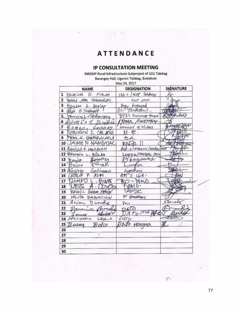
77

78
Consultation meeting with the IP in Barangay Liguron, Talakag, Bukidnon. May 24, 2017

79

80
Appendix 5: Sangguniang Bayan Resolution

81
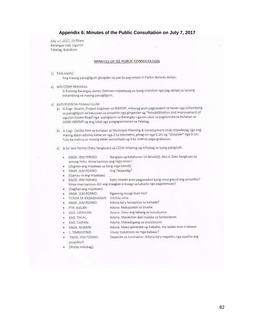
82
Appendix 6: Minutes of the Public Consultation on July 7, 2017

83

84

85

86

87
Appendix 7: Grievance Intake Form
Name of Project, Subproject and Location
Project (indicate name of project) welcomes complaints, suggestions, comments and queries regarding the project implementation and its stakeholders. We encourage persons with grievance to provide their name and contact information to enable us to get in touch with you for clarification and feedback. Should you choose to include your personal details but want that information to remain confidential, please inform us by writing/typing "(CONFIDENTIAL)" above your name. Thank you.
Contact Information
Name Gender □ Male □ Female
Home Address
Age
Phone No.
City/Province Email
Complaint/Suggestion/Comment/Question Please provide the details (who, what, where and how) of your grievance below:

88
How do you want us to reach you for feedback or update on your comment/grievance?
Portion to be filled in by PPCO staff (designated Grievance Redress Mechanism Officer):
Date received:
Received through:
__ In person __ mail __ email __ fax __ phone __ sms
Name of staff who received comment/ complaint
Position of staff:
Type of Grievance:
Remarks
Signature of staff

89
Updates on the case:
Date: Update Updated by (Name, Signature and Designation)