Phaedon C. Kyriakidis Curriculum Vitaephaedon/cv.pdf · 2012-15 Professor, Dept. of Geography,...
29
1 Department of Civil Engineering and Geomatics Cyprus University of Technology Achilleos 1 Bldg., 1st Floor 2-8 Saripolou Str., 3036 Lemesos, CYPRUS Tel: +(357) 25002542 Fax: +(357) 25002769 [email protected] www.cut.ac.cy/ceg/ Phaedon C. Kyriakidis Curriculum Vitae Last update: October 2015 Education 1999 • Ph.D.: Department of Geological & Environmental Sciences, Stanford University, U.S.A. Specialization: Geostatistics in the Earth Sciences. Thesis advisor: Prof. Andr´ e G. Journel. 1994 • B.Sc. (Ptychion): Department of Geology, Aristotelian University of Thessaloniki, Greece. Professional Appointments 2015- • Professor, Dept. of Civil Engineering and Geomatics, Faculty of Engineering and Tech- nology, Cyprus University of Technology, Cyprus 2015- • Adjunct Professor, Dept. of Geography, University of California Santa Barbara, U.S.A. 2012-14 • Vice Chair & Graduate Advisor, Dept. of Geography, University of California Santa Barbara, U.S.A. 2012-15 • Professor, Dept. of Geography, University of California Santa Barbara, U.S.A. 2010-12 • Director of Graduate Studies Program in: Geography and Applied Geo-Informatics, Dept. of Geography, University of the Aegean, Greece. 2010- • Professor of Spatial Analysis, Dept. of Geography, University of the Aegean, Greece (on leave of absence). 2009-10 • Instructor on short-term contract at the Professorial level (presidential decree 407/1982), Dept. of Geography, University of the Aegean, Greece. 2008-09 • Vice Chair & Graduate Advisor, Dept. of Geography, University of California Santa Barbara, U.S.A. 2005-12 • Associate Professor, Dept. of Geography, University of California Santa Barbara, U.S.A. – on leave-of-absence (without salary) from September 2009 to December 2012. 2001-13 • Faculty Staff, Earth Sciences Division, Berkeley National Laboratory, U.S.A. 2001-05 • Assistant Professor, Dept. of Geography, University of California Santa Barbara, U.S.A. 1999-00 • Post-doctoral Fellow, Earth Sciences Division, Berkeley National Laboratory, U.S.A. 1994-99 • Graduate Research Assistant, Dept. of Geological & Environmental Sciences, Stanford University, U.S.A. 1997 • Visiting Graduate Research Assistant (June-August), National Center for Geographic Information and Analysis (NCGIA), University of California Santa Barbara, U.S.A. 1996 • Visiting Graduate Research Assistant (June-August), Earth and Environmental Sci- ences Division GeoAnalysis (EES-5) Group, Los Alamos National Laboratory, U.S.A.
Transcript of Phaedon C. Kyriakidis Curriculum Vitaephaedon/cv.pdf · 2012-15 Professor, Dept. of Geography,...

1
Department of Civil Engineering and GeomaticsCyprus University of TechnologyAchilleos 1 Bldg., 1st Floor2-8 Saripolou Str., 3036 Lemesos, CYPRUS
Tel: +(357) 25002542Fax: +(357) 25002769
[email protected]/ceg/
Phaedon C. KyriakidisCurriculum Vitae
Last update: October 2015
Education
1999 • Ph.D.: Department of Geological & Environmental Sciences, Stanford University, U.S.A.Specialization: Geostatistics in the Earth Sciences. Thesis advisor: Prof. Andre G. Journel.
1994 • B.Sc. (Ptychion): Department of Geology, Aristotelian University of Thessaloniki, Greece.
Professional Appointments
2015- • Professor, Dept. of Civil Engineering and Geomatics, Faculty of Engineering and Tech-nology, Cyprus University of Technology, Cyprus
2015- • Adjunct Professor, Dept. of Geography, University of California Santa Barbara, U.S.A.2012-14 • Vice Chair & Graduate Advisor, Dept. of Geography, University of California Santa
Barbara, U.S.A.2012-15 • Professor, Dept. of Geography, University of California Santa Barbara, U.S.A.2010-12 • Director of Graduate Studies Program in: Geography and Applied Geo-Informatics,
Dept. of Geography, University of the Aegean, Greece.2010- • Professor of Spatial Analysis, Dept. of Geography, University of the Aegean, Greece
(on leave of absence).2009-10 • Instructor on short-term contract at the Professorial level (presidential decree
407/1982), Dept. of Geography, University of the Aegean, Greece.2008-09 • Vice Chair & Graduate Advisor, Dept. of Geography, University of California Santa
Barbara, U.S.A.2005-12 • Associate Professor, Dept. of Geography, University of California Santa Barbara, U.S.A.
– on leave-of-absence (without salary) from September 2009 to December 2012.2001-13 • Faculty Staff, Earth Sciences Division, Berkeley National Laboratory, U.S.A.2001-05 • Assistant Professor, Dept. of Geography, University of California Santa Barbara, U.S.A.1999-00 • Post-doctoral Fellow, Earth Sciences Division, Berkeley National Laboratory, U.S.A.1994-99 • Graduate Research Assistant, Dept. of Geological & Environmental Sciences, Stanford
University, U.S.A.1997 • Visiting Graduate Research Assistant (June-August), National Center for Geographic
Information and Analysis (NCGIA), University of California Santa Barbara, U.S.A.1996 • Visiting Graduate Research Assistant (June-August), Earth and Environmental Sci-
ences Division GeoAnalysis (EES-5) Group, Los Alamos National Laboratory, U.S.A.

2
Honors, Distinctions & Awards
2015 • Best poster award: “Delineating water quality regions from remotely sensed data usingtextural information” (co-authored with Vasios and Kitsiou), and presented at the ThirdInternational Conference on Remote Sensing and Geoinformation of Environment (RSCy2015), on March 16-19 2015, in Paphos, Cyprus.
2014 • Best paper award: “Efficient simulation of (Log)Normal Random Fields for Hydrogeolog-ical Applications” (co-authored with Gaganis), published in Mathematical Geosciences,45(6): 531-556. Selected as the best paper for 2013 (out of a total of 48 publishedpapers); see the related announcement of the International Association for Mathemat-ical Geosciences (IAMG) in the November 2014 issue of Mathematical Geosciences,46(8): 1035-1037, DOI 10.1007/s11004-014-9572-8, as well as in the biannual IAMGNewsletter No. 89 (Winter 2014).
2012 • National (Greek) competition in scientific research excellence “Aristeia”: Advances inGeostatistics for Environmental Characterization and Natural Resources Management wasselected for funding (e250, 000) in the 1st Greek national competition in scientific researchexcellence, “Aristeia”, administered by the Greek General Secretariat for Research andTechnology. This proposal was one of the 206 proposals selected for funding out of a total of
1497 proposals submitted. It also was one of the 14 proposals (out of the 206 retained) that was
funded as interdisciplinary – Primary disciplinary field: 01. Mathematics, Statistics, Informatics
and Computer Science; Secondary disciplinary field: 10. Energy and the Environment.
2010 • Best paper award: “Geostatistical Regression for Areal Data” (co-authored with Nagle),and published in the proceedings of the 9th International Symposium on Spatial AccuracyAssessment in Natural Resources and Environmental Sciences, Leicester, UK, July 20-23.
1999 • Exemption (until 2003) from the obligatory military services of Greece due to distinguishedscientific activities abroad.
1997 • First place in written competition on Statistics in Geology organized by the NationalScholarship Foundation of Greece.
1994 • Honors degree from the Department of Geology of the Aristotelian University of Thessa-loniki, Greece. Highest GPA in graduating class, and among the five highest GPAs in theDepartment’s history.
Research Interests
Geostatistics, Geocomputation, Geoinformatics• Development of geostatistical and geocomputation methodologies for: (a) quantifying and
interpreting spatial and/or spatiotemporal patterns in geographical variables, (b) integratingspatial and/or spatiotemporal data of different resolution and reliability, (c) modeling un-certainty in the spatiotemporal distribution of geographical variables, and (d) propagatingefficiently uncertainty in the spatiotemporal distribution of environmental model parametersto model predictions.
• Application of the above methodologies of spatiotemporal data analysis and modeling to Ge-ographic Information Science, as well as Earth, Environmental and Social Sciences.
• Development and application of geostatistical methodologies for mineral resources assessmentand reservoir characterization.

3
Grants & Contracts
2014-19 • Demonstrating an Effective Marine Biodiversity Observation Network in the SantaBarbara Channel. PI: Miller, Co-PIs: Carlson, Lafferty, Rassweiler, Reed, Kyriakidis,Siegel, Iglesias-Rodriguez, Manjunath, Love, Thompson, Hildebrand, McCauley. Fund-ing sources: NASA, NOAA. This project is funded as part of the US National Oceano-graphic Partnership Program federal funding opportunity “FY2014 Demonstration of aU.S. Marine Biodiversity Observation Network (Marine BON)”, with an overall budgetof approximately $6, 000, 000 over 5 years.
2013-15 • Collaborative Research: Thermal Controls on Ecosystem Metabolism and Function:Scaling from Leaves to Canopies to Regions. PI: Roberts, Co-I: Kyriakidis. Fundingsource: National Science Foundation (NSF). Amount: $255, 000. This project is part
of a larger collaborative project involving Oregon State, Harvard, UPenn, UC Irvine, and
UC Santa Barbara, led by Prof. Still at Oregon State, and funded by NSF’s MacroSystems
Biology program with an overall budget of approximately $1, 008, 000 over 2 years.
2012-15 • Advances in Geostatistics for Environmental Characterization and Natural ResourcesManagement. PI: Kyriakidis. Funding source: Greek General Secretariat for Researchand Technology. Amount: e250, 000.
2007-11 • A Geostatistical Framework for Geospatial Data Analysis and Modeling Across MultipleSpatial and Temporal Scales. PI: Goodchild, Co-PI: Kyriakidis. Funding source:National Geospatial-Intelligence Agency (NGA). Amount: $450, 000.
2008-09 • Modeling Soil Moisture in California Across Multiple Scales. PI: Chadwick, Co-PIs:Roberts & Kyriakidis. Funding source: Kearney Foundation of Soil Science ($88, 951).
2007-09 • Remote Assessment of Giant Kelp Dynamics – The Engineer of California’s Near-ShoreEcosystems. PI: Siegel, Co-I: Kyriakidis. Funding source: National Aeronautics andSpace Administration (NASA). Amount: $859, 049.
2005-06 • Intra-urban Industrial Location Under Institutional and Accessibility Constraints: AnEmpirical Approach. PI: Sweeney, Co-PI: Kyriakidis. Funding source: National Sci-ence Foundation (NSF). Amount: $100, 000.
2004-06 • A Geostatistical Framework for Downscaling Spatial Data. PI: Kyriakidis. Fundingsource: National Science Foundation (NSF). Amount: $125, 002.
2004-06 • An Integrated, Dynamic and Predictive Model of Wildfire Risk in Southern CaliforniaUsing MODIS Imagery. PI: Kyriakidis, Co-PI: Schneider. Funding source: NationalAeronautics and Space Administration (NASA). Amount: $48, 000.
2004-07 • Strategic Enhancement of NGA’s Geographic Information Science Infrastructure PI:Goodchild, Co-I: Kyriakidis. Funding source: National Geospatial-Intelligence Agency(NGA). Amount: $693, 000.
2004-05 • Instructional Improvement Grant: An Integrated Software Environment for EnhancedGeographic Education. PIs: Sweeney and Kyriakidis. Funding source: AcademicSenate University of California Santa Barbara. Amount: $24, 000.
2003-05 • A Systems Approach to the Visualization of Spatial Uncertainty. PI: Kyriakidis.Funding source: National Science Foundation. Amount: $69, 951.
2002-03 • Sub-County Population and Household Projections for SCAG Sub-Regions, Cities, andUnincorporated Areas to 2025. PI: Sweeney, Co-PI: Kyriakidis. Funding source:Southern California Association of Governments (SCAG). Amount: $74, 937.
2001 • Junior Faculty Research Incentive Award. PI: Kyriakidis. Funding source: AcademicSenate, University of California Santa Barbara. Amount: $5, 000.
4
Publications
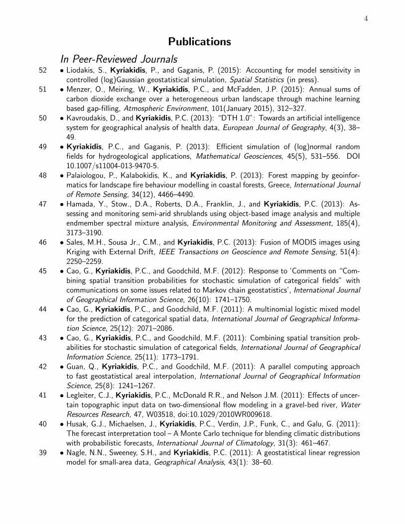
In Peer-Reviewed Journals52 • Liodakis, S., Kyriakidis, P., and Gaganis, P. (2015): Accounting for model sensitivity in
controlled (log)Gaussian geostatistical simulation, Spatial Statistics (in press).51 • Menzer, O., Meiring, W., Kyriakidis, P.C., and McFadden, J.P. (2015): Annual sums of
carbon dioxide exchange over a heterogeneous urban landscape through machine learningbased gap-filling, Atmospheric Environment, 101(January 2015), 312–327.
50 • Kavroudakis, D., and Kyriakidis, P.C. (2013): “DTH 1.0”: Towards an artificial intelligencesystem for geographical analysis of health data, European Journal of Geography, 4(3), 38–49.
49 • Kyriakidis, P.C., and Gaganis, P. (2013): Efficient simulation of (log)normal randomfields for hydrogeological applications, Mathematical Geosciences, 45(5), 531–556. DOI10.1007/s11004-013-9470-5.
48 • Palaiologou, P., Kalabokidis, K., and Kyriakidis, P. (2013): Forest mapping by geoinfor-matics for landscape fire behaviour modelling in coastal forests, Greece, International Journalof Remote Sensing, 34(12), 4466–4490.
47 • Hamada, Y., Stow., D.A., Roberts, D.A., Franklin, J., and Kyriakidis, P.C. (2013): As-sessing and monitoring semi-arid shrublands using object-based image analysis and multipleendmember spectral mixture analysis, Environmental Monitoring and Assessment, 185(4),3173–3190.
46 • Sales, M.H., Sousa Jr., C.M., and Kyriakidis, P.C. (2013): Fusion of MODIS images usingKriging with External Drift, IEEE Transactions on Geoscience and Remote Sensing, 51(4):2250–2259.
45 • Cao, G., Kyriakidis, P.C., and Goodchild, M.F. (2012): Response to ’Comments on “Com-bining spatial transition probabilities for stochastic simulation of categorical fields” withcommunications on some issues related to Markov chain geostatistics’, International Journalof Geographical Information Science, 26(10): 1741–1750.
44 • Cao, G., Kyriakidis, P.C., and Goodchild, M.F. (2011): A multinomial logistic mixed modelfor the prediction of categorical spatial data, International Journal of Geographical Informa-tion Science, 25(12): 2071–2086.
43 • Cao, G., Kyriakidis, P.C., and Goodchild, M.F. (2011): Combining spatial transition prob-abilities for stochastic simulation of categorical fields, International Journal of GeographicalInformation Science, 25(11): 1773–1791.
42 • Guan, Q., Kyriakidis, P.C., and Goodchild, M.F. (2011): A parallel computing approachto fast geostatistical areal interpolation, International Journal of Geographical InformationScience, 25(8): 1241–1267.
41 • Legleiter, C.J., Kyriakidis, P.C., McDonald R.R., and Nelson J.M. (2011): Effects of uncer-tain topographic input data on two-dimensional flow modeling in a gravel-bed river, WaterResources Research, 47, W03518, doi:10.1029/2010WR009618.
40 • Husak, G.J., Michaelsen, J., Kyriakidis, P.C., Verdin, J.P., Funk, C., and Galu, G. (2011):The forecast interpretation tool – A Monte Carlo technique for blending climatic distributionswith probabilistic forecasts, International Journal of Climatology, 31(3): 461–467.
39 • Nagle, N.N., Sweeney, S.H., and Kyriakidis, P.C. (2011): A geostatistical linear regressionmodel for small-area data, Geographical Analysis, 43(1): 38–60.

5
Publications
38 • Yoo, E.-H., Kyriakidis, P.C., and Tobler, W. (2010): Reconstructing population densitysurfaces from areal data: A comparison of Tobler’s pycnophylactic interpolation methodand area-to-point Kriging, Geographical Analysis, 42(1): 78–98.
37 • Yoo, E.-H., and Kyriakidis, P.C. (2009): Area-to-point Kriging in spatial hedonic pricingmodels, Journal of Geographical Systems, 11(4): 381–406.
36 • Zhang, J., Kyriakidis, P.C., and Kelly, R. (2009): Geostatistical approaches to conflationof continental snow data, International Journal of Remote Sensing, 30(20): 5441–5451.
35 • Goodchild, M.F, Zhang, J., and Kyriakidis, P.C. (2009): Discriminant models of uncertaintyin nominal fields, Transactions in GIS, 13(1): 7–23.
34 • Park, N.-W., and Kyriakidis, P.C. (2008): Geostatistical integration of different sources ofelevation and its effect on landslide hazard mapping, Korean Journal of Remote Sensing,24(5): 453–462.
33 • Yoo, E.-H., and Kyriakidis, P.C. (2008): Area-to-point prediction under boundary condi-tions, Geographical Analysis, 40(4): 355–379.
32 • Schneider, P., Roberts, D.A., and Kyriakidis, P.C. (2008): A VARI-based relative greennessfrom MODIS data for computing the Fire Potential Index, Remote Sensing of Environment112(3): 1151–1167.
31 • Liu, X., Kyriakidis, P.C., and Goodchild, M.F. (2008): Population density estimation usingregression and area-to-point residual Kriging, International Journal of Geographical Infor-mation Science 22(4): 431–447.
30 • Legleiter, C., and Kyriakidis, P.C. (2008): Spatial prediction of river channel topographyby Kriging, Earth Surface Processes and Landforms 33(6): 841–867.
29 • Boucher, A., Kyriakidis, P.C., and Cronkite-Ratcliff, C. (2008): Geostatistical solutions forsuper-resolution land cover mapping, IEEE Transactions on Geoscience and Remote Sensing,46(1): 272–283.
28 • Zhang, J., Goodchild, M., and Kyriakidis, P. (2007): A conceptual framework for categor-ical mapping and error modeling, Acta Geodaetica et Cartographica Sinica, 3(8): 296–301.
27 • Sales, M.H., Souza Jr., C.M., Kyriakidis, P.C., Roberts, D.A., and Vidal, E. (2007): Im-proving spatial distribution estimation of aboveground forest biomass with geostatistics: Acase study of Rondonia, Brazil, Ecological Modelling, 205(1-2): 221–230.
26 • Ekstrom, M., Kyriakidis, P.C., Chappell, A., and Jones, P. (2007): Spatiotemporal stochas-tic simulation of monthly rainfall patterns in the United Kingdom (1980-1987), Journal ofClimate, 20(16): 4194–4210.
25 • Boucher, A., and Kyriakidis, P.C. (2007): Integrating fine scale information in super-resolution land cover mapping, Photogrammetric Engineering & Remote Sensing, 73(8):913–921.
24 • Legleiter, C., and Kyriakidis, P.C. (2006): Forward and inverse transformations betweenCartesian and channel-fitted coordinate systems for meandering rivers, Mathematical Geol-ogy, 38(8): 927–958.
23 • Yoo, E.-H., and Kyriakidis, P.C. (2006): Area-to-point Kriging with inequality-type data,Journal of Geographical Systems, 8(4): 357–390.
22 • Boucher, A., and Kyriakidis, P.C. (2006): Super-resolution land cover mapping with indi-cator geostatistics, Remote Sensing of Environment, 104(3): 264–282.
6
Publications
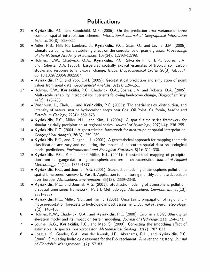
21 • Kyriakidis, P.C., and Goodchild, M.F. (2006): On the prediction error variance of threecommon spatial interpolation schemes, International Journal of Geographical InformationScience, 20(8): 823–855.
20 • Adler, P.B., Hille Ris Lambers, J., Kyriakidis, P.C., Guan, Q., and Levine, J.M. (2006):Climate variability has a stabilizing effect on the coexistence of prairie grasses, Proceedingsof the National Academy of Sciences, 103(34): 12793–12798.
19 • Holmes, K.W., Chadwick, O.A., Kyriakidis, P.C., Silva de Filho, E.P., Soares, J.V.,and Roberts, D.A. (2006): Large-area spatially explicit estimates of tropical soil carbonstocks and response to land-cover change, Global Biogeochemical Cycles, 20(3), GB3004,doi:10.1029/2005GB002507.
18 • Kyriakidis, P.C., and Yoo, E.-H. (2005): Geostatistical prediction and simulation of pointvalues from areal data, Geographical Analysis, 37(2): 124–151.
17 • Holmes, K.W., Kyriakidis, P.C., Chadwick, O.A., Soares, J.V. and Roberts, D.A. (2005):Multi-scale variability in tropical soil nutrients following land-cover change, Biogeochemistry,74(2): 173–203.
16 • Washburn, L., Clark, J., and Kyriakidis, P.C. (2005): The spatial scales, distribution, andintensity of natural marine hydrocarbon seeps near Coal Oil Point, California, Marine andPetroleum Geology, 22(4): 569–578.
15 • Kyriakidis, P.C., Miller, N.L., and Kim, J. (2004): A spatial time series framework forsimulating daily precipitation at regional scales, Journal of Hydrology, 297(1-4): 236–255.
14 • Kyriakidis, P.C. (2004): A geostatistical framework for area-to-point spatial interpolation,Geographical Analysis, 36(3): 259–289.
13 • Kyriakidis, P.C., and Dungan, J.L. (2001): A geostatistical approach for mapping thematicclassification accuracy and evaluating the impact of inaccurate spatial data on ecologicalmodel predictions, Environmental and Ecological Statistics, 8(4): 311–330.
12 • Kyriakidis, P.C., Kim, J., and Miller, N.L. (2001): Geostatistical mapping of precipita-tion from rain gauge data using atmospheric and terrain characteristics, Journal of AppliedMeteorology, 40(11): 1855–1877.
11 • Kyriakidis, P.C., and Journel, A.G. (2001): Stochastic modeling of atmospheric pollution, aspatial time series framework. Part II: Application to monitoring monthly sulphate depositionover Europe, Atmospheric Environment, 35(13): 2339–2348.
10 • Kyriakidis, P.C., and Journel, A.G. (2001): Stochastic modeling of atmospheric pollution,a spatial time series framework. Part I: Methodology, Atmospheric Environment, 35(13):2331–2337.
9 • Kyriakidis, P.C., Miller, N.L., and Kim, J. (2001): Uncertainty propagation of regional cli-mate precipitation forecasts to hydrologic impact assessment, Journal of Hydrometeorology,2(2): 140–160.
8 • Holmes, K.W., Chadwick, O.A., and Kyriakidis, P.C. (2000): Error in a USGS 30m digitalelevation model and its impact on terrain modeling, Journal of Hydrology, 233: 154–173.
7 • Journel, A.G., Kyriakidis, P.C., and Mao, S. (2000): Correcting the smoothing effect ofestimators: A spectral post-processor, Mathematical Geology, 32(7): 787–813.
6 • Loague, K., Gander, G.A., Van der Kwaak, J.E., Abrahams, R.H., and Kyriakidis, P.C.(2000): Simulating hydrologic response for the R-5 catchment: A never ending story, Journalof Floodplain Management, 1(2): 57–83.

7
Publications
5 • Kyriakidis, P.C., and Journel, A.G. (1999): Geostatistical space-time models, MathematicalGeology, 31(6): 651–684.
4 • Kyriakidis, P.C., Deutsch, C.V., and Grant, M.L. (1999): Calculation of the normal scoresvariogram for truncated Gaussian lithofacies simulation: Theory and FORTRAN code, Com-puters & Geosciences, 25(2): 161–169.
3 • Kyriakidis, P.C., Shortridge, A.M., and Goodchild, M.F. (1999): Geostatistics for conflationand accuracy assessment of digital elevation models, International Journal of GeographicalInformation Science, 13(7): 677–708.
2 • Wahlstrom, E., Loague, K., and Kyriakidis, P.C. (1999): Hydrologic response: Kaho’olawe,Hawaii, Journal of Environmental Quality, 28: 481–492.
1 • Loague, K., and Kyriakidis, P.C. (1997): Spatial and temporal variability in the R-5 infil-tration data set: Deja vu and rainfall-runoff simulations, Water Resources Research, 33(12):2883–2895.
In Peer-Reviewed Conference Proceedings18 • Liodakis, S.C., Kyriakids, P.C., and Gaganis, P. (2015): Efficient uncertainty propagation
of lognormal hydraulic conductivity in a three dimensional hydrogeological model of flowand transport on very large regular grids, in: Proceedings of the 17th Annual Conference ofthe International Association for Mathematical Geosciences (IAMG 2015), September 5-13,2015, Freiberg (Saxony), Germany.
17 • Vasios, G.K., Kyriakidis, P.C., and Kitsiou, D. (2015): Measurement aggregation effects onthe spatial statistics of sea surface temperature (SST) and chlorophyll (Chl-a) over the NorthAegean, in: Proceedings of the 14th International Conference on Environmental Science andTechnology (CEST 2015), September 3-5, Rhodes, Greece.
16 • Liodakis, S., Kyriakidis, P.C., and Gaganis, P. (2015): Efficient uncertainty analysis ina three dimensional hydrogeological model of flow and transport, in: Proceedings of the14th International Conference on Environmental Science and Technology (CEST 2015),September 3-5, Rhodes, Greece.
15 • Mwenda, K., Kyriakidis, P., and Lopez-Carr, D. (2015): Exploring HIV prevalence esti-mates using fine-scale population estimates: Evidence from three Tanzanian districts, in:Proceedings of the 19th European Colloquium on Theoretical and Quantitative Geography(ECTQG2015), Bari, Italy, 3-7 September 2011. Draft also published in: Plurimondi. AnInternational Forum for Research and Debate on Human Settlements, 7(15), in press.
14 • Lopez-Carr, D., Mwenda, K.,M., Pricope, N.G., Kyriakidis, P.C., Jankowska, M.M., Weeks,J., Funk, C., Husak, G., and Michaelsen, J. (2015): A spatial analysis of climate-relatedchild malnutrition in the Lake Victoria basin, in: Proceedings of the 2015 InternationalGeoscience and Remote Sensing Symposium (IGARSS 2015), July 26-31, Milan, Italy.
13 • Kyriakidis, P.C., Vasios, G., and Kitsiou, D. (2015): Delineating sea surface water qual-ity regions from remotely sensed data using textural information, in: Hadjimitsis, D.,Themistocleous, K., Michaelides, S., and Papadavid, G. (Eds.), Proceedings of SPIE 9535,Third International Conference on Remote Sensing and Geoinformation of the Environment(RSCy2015), 95351W (June 19, 2015); doi:10.1117/12.2192565.

8
Publications
12 • Vasios, G.K., Kyriakidis, P.C., and Kitsiou, D. (2015): Incorporating multivariate spa-tial association information for delineating sea water quality regions over the Aegean, in:Proceedings of the 11th Panhellenic Symposium on Oceanography and Fisheries: AquaticHorizons Challenges and Perspectives, pp 889-892, May 13-17, Mytilene, Lesvos, Greece.
11 • Kyriakidis, P.C., Kitsiou, D., and Kavroudakis, D. (2013): Multivariate variogram andmadogram: Tools for quantifying diversity/dissimilarity in spatiotemporal data, in: E. Pardo-Iguzquiza, C. Guardiola-Albert, J. Hereida, L. Moreno-Merino, J.J. Duran, J.A. Vargas-Guzman, Editors, Mathematics of Planet Earth, Proceedings of the 15th Annual Conferenceof the International Association for Mathematical Geosciences, Madrid, Spain, September2013, Lecture Notes in Earth System Sciences, Springer, pp. 235–238.
10 • Zargli, E., Liodakis, S., Kyriakidis, P., and Savvaidis, A. (2013): Classification of topog-raphy using DEM data and its correlation with the geology of Greece, First InternationalConference on Remote Sensing and Geoinformation of the Environment (RSCy2013), editedby: Diofantos G. Hadjimitsis, Kyriacos Themistocleous, Silas Michaelides, George Papa-david, Proc. of SPIE Vol. 8795, doi: 10.1117/12.2028801, Paphos, Cyprus, April 2013.
9 • Maina, I., Siapatis, A., Kavadas, S., Kyriakidis, P., Georgakarakos, S., and Somarakis, S.(2012): Geographic Information Systems and Generalized Additive Models for predictingpotential spawning habitats of anchovy (in Greek), in Proceedings of the 10th PanhellenicSymposium of Oceanography and Fisheries, Athens, Greece, May 2012.
8 • Kavroudakis, D., and Kyriakidis, P.C. (2011): Towards an artificial intelligence health deci-sion support system, in: Proceedings of the 17th European Colloquium on Theoretical andQuantitative Geography (ECTQG2011), Harokopeio University, Athens, Greece, September2-5, 2011.
7 • Kyriakidis, P.C. (2011): Popular cartographic areal interpolation methods viewed from ageostatistical perspective, in Proceedings of the 25th International Cartographic Conference,Paris, France, July 2011.
6 • Papakonstantinou, A., Varsamis, D., Soulakellis, N., and Kyriakidis, P.C. (2011): InsetMapper: A tool for scale selection and inset placing configuration of multiple insets inisland cartography, in Proceedings of the 25th International Cartographic Conference, Paris,France, July 2011.
5 • Cao, G., Kyriakidis, P.C., and Goodchild, M.F. (2009): Prediction and simulation in cat-egorical fields: A transition probability combination approach, in: Proceedings of the 17thACM SIGSPATIAL International Conference on Advances in Geographic Information Sys-tems, Seattle, Washington, November 2009.
4 • Zhang, J., Goodchild, M.F., Kyriakidis, P.C., and Rao, X. (2006): Categorical mappingand error modeling based on the discriminant space. in: J. Gong, and J. Zhang (Eds.),Proceedings of SPIE – Volume 6420, Geoinformatics 2006: Geospatial Information Science,64201H.
3 • Kyriakidis, P.C. (2005): Sequential spatial simulation using Latin hypercube sampling, in:O. Leuangthong, and C.V. Deutsch (Eds.), Geostatistics Banff 2004: Seventh InternationalGeostatistics Congress, Quantitative Geology and Geostatistics, 14(1): 65–74, Kluwer Aca-demic Publishers, Dordrecht, The Netherlands.
9
Publications
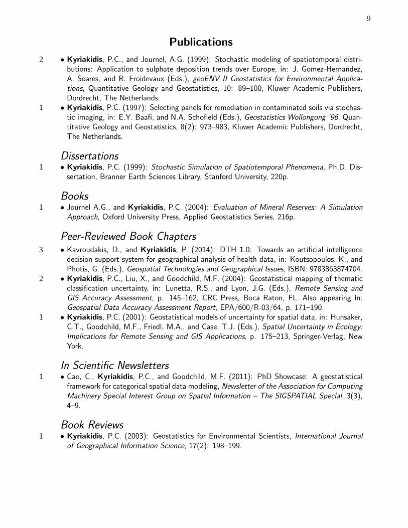
2 • Kyriakidis, P.C., and Journel, A.G. (1999): Stochastic modeling of spatiotemporal distri-butions: Application to sulphate deposition trends over Europe, in: J. Gomez-Hernandez,A. Soares, and R. Froidevaux (Eds.), geoENV II Geostatistics for Environmental Applica-tions, Quantitative Geology and Geostatistics, 10: 89–100, Kluwer Academic Publishers,Dordrecht, The Netherlands.
1 • Kyriakidis, P.C. (1997): Selecting panels for remediation in contaminated soils via stochas-tic imaging, in: E.Y. Baafi, and N.A. Schofield (Eds.), Geostatistics Wollongong ’96, Quan-titative Geology and Geostatistics, 8(2): 973–983, Kluwer Academic Publishers, Dordrecht,The Netherlands.
Dissertations1 • Kyriakidis, P.C. (1999): Stochastic Simulation of Spatiotemporal Phenomena, Ph.D. Dis-
sertation, Branner Earth Sciences Library, Stanford University, 220p.
Books1 • Journel A.G., and Kyriakidis, P.C. (2004): Evaluation of Mineral Reserves: A Simulation
Approach, Oxford University Press, Applied Geostatistics Series, 216p.
Peer-Reviewed Book Chapters3 • Kavroudakis, D., and Kyriakidis, P. (2014): DTH 1.0: Towards an artificial intelligence
decision support system for geographical analysis of health data, in: Koutsopoulos, K., andPhotis, G. (Eds.), Geospatial Technologies and Geographical Issues, ISBN: 9783863874704.
2 • Kyriakidis, P.C., Liu, X., and Goodchild, M.F. (2004): Geostatistical mapping of thematicclassification uncertainty, in: Lunetta, R.S., and Lyon, J.G. (Eds.), Remote Sensing andGIS Accuracy Assessment, p. 145–162, CRC Press, Boca Raton, FL. Also appearing In:Geospatial Data Accuracy Assessment Report, EPA/600/R-03/64, p. 171–190.
1 • Kyriakidis, P.C. (2001): Geostatistical models of uncertainty for spatial data, in: Hunsaker,C.T., Goodchild, M.F., Friedl, M.A., and Case, T.J. (Eds.), Spatial Uncertainty in Ecology:Implications for Remote Sensing and GIS Applications, p. 175–213, Springer-Verlag, NewYork.
In Scientific Newsletters1 • Cao, C., Kyriakidis, P.C., and Goodchild, M.F. (2011): PhD Showcase: A geostatistical
framework for categorical spatial data modeling, Newsletter of the Association for ComputingMachinery Special Interest Group on Spatial Information – The SIGSPATIAL Special, 3(3),4–9.
Book Reviews1 • Kyriakidis, P.C. (2003): Geostatistics for Environmental Scientists, International Journal
of Geographical Information Science, 17(2): 198–199.

10
Publications
In Conference Proceedings (not peer-reviewed)
accepted after extended abstract review
17 • Kavroudakis, D., Vasios, G. Kyriakidis, P. (2014): Quantification of multivariate(dis)similarity in geospatial data with the use of Free/Open source software (in Greek), in:Proceedings of the 8th Panhellenic Conference of the Hellenic Association for GeographicalInformation Systems (HellasG.I.s), Athens, Greece, December 11-12, 2014.
16 • Kyriakidis, Ph., Polydoropoulos, I., and Kizos, Th.: Global and local indicators of multivari-ate spatial association: A case study of accessibility between islands of the North and SouthAegean prefectures and Attica, 10th International Congress of the Hellenic GeographicalSociety, Thessaloniki, Greece, October 2014.
15 • Liodakis, S., Kyriakidis, Ph., and Gaganis, P.: Latin hypercube simulation of hydraulicconductivity fields for efficient parameter uncertainty assessment in flow and transport prob-lems, 10th International Congress of the Hellenic Geographical Society, Thessaloniki, Greece,October 2014.
14 • Ravulaparthy, S., Goulias, K.G., Sweeney, S., and Kyriakidis, P.C. (2013): Exploring thespatial and temporal patterns of business concentration and dispersion: A case study ofanalysis for County of Santa Barbara, in proceedings of: 52nd Annual Meeting of WesternRegional Science Association, Santa Barbara, CA, February 24-27, 2013.
13 • Kalabokidis, K., Palaiologou, P., and Kyriakidis, P.C. (2010): Forest fire fuels mappingby geoinformatics for fire behavior modeling, in: D.X. Viegas (Ed.), Proceedings of the 6th
International Conference on Forest Fire Research, Coimbra, Portugal, November 2010.12 • Kyriakidis, P.C., and Cao, G. (2010): Generating fine resolution area class maps subject to
coarser resolution data constraints, in: R.S. Purves, and R. Weibel (Eds.), GIScience 2010:Extended Abstracts Volume of the 6th International Conference on Geographic InformationScience, Zurich, Switzerland, September 2010.
11 • Kyriakidis, P.C., and Nagle, N.N. (2010): Geostatistical regression for areal data, in: N.Tate, and P. Fisher (Eds.), Proceedings of the 9th International Symposium on SpatialAccuracy Assessment in Natural Resources and Environmental Sciences, Leicester, UK, June2010.
10 • Cao, G., and Kyriakidis, P.C. (2008): Combining transition probabilities in the predictionand simulation of categorical fields, in: J. Zhang, and M.F. Goodchild (Eds.), Proceedingsof the 8th International Symposium on Spatial Accuracy Assessment in Natural Resourcesand Environmental Sciences, Shanghai, China, June.
9 • Zhang, J., Kyriakidis, P.C., and Kelly, R. (2008): Geostatistical approaches to conflationof continental snow data, in: J. Zhang, and M.F. Goodchild (Eds.), Proceedings of the8th International Symposium on Spatial Accuracy Assessment in Natural Resources andEnvironmental Sciences, Shanghai, China, June 2008.
8 • Boucher, A., and Kyriakidis, P.C. (2006): Geostatistical solutions for super-resolution landcover mapping, in: Proceedings of the 2006 Annual Conference of the Remote Sensing andPhotogrammetry Society, Cambridge, UK, September 2006.
7 • Kyriakidis, P.C. (2006) Towards a systems approach to the visualization of spatial uncer-tainty, in: M. Caetano, and M. Painho (Eds.), Proceedings of the 7th International Sym-posium on Spatial Accuracy Assessment in Natural Resources and Environmental Sciences,Lisbon, Portugal, July 2006.
11
Publications
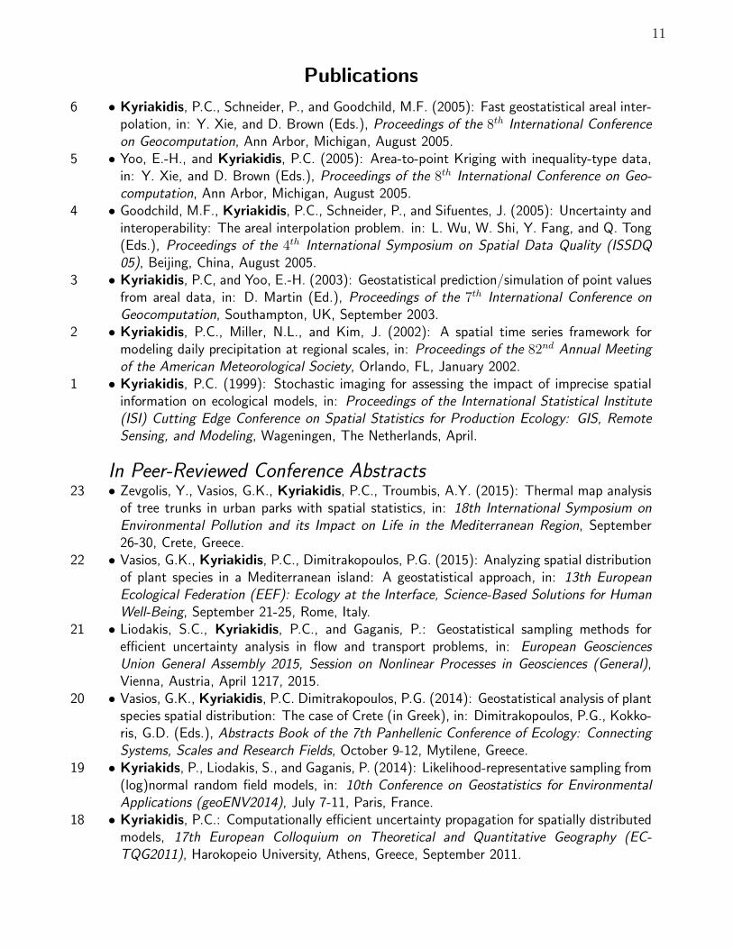
6 • Kyriakidis, P.C., Schneider, P., and Goodchild, M.F. (2005): Fast geostatistical areal inter-polation, in: Y. Xie, and D. Brown (Eds.), Proceedings of the 8th International Conferenceon Geocomputation, Ann Arbor, Michigan, August 2005.
5 • Yoo, E.-H., and Kyriakidis, P.C. (2005): Area-to-point Kriging with inequality-type data,in: Y. Xie, and D. Brown (Eds.), Proceedings of the 8th International Conference on Geo-computation, Ann Arbor, Michigan, August 2005.
4 • Goodchild, M.F., Kyriakidis, P.C., Schneider, P., and Sifuentes, J. (2005): Uncertainty andinteroperability: The areal interpolation problem. in: L. Wu, W. Shi, Y. Fang, and Q. Tong(Eds.), Proceedings of the 4th International Symposium on Spatial Data Quality (ISSDQ05), Beijing, China, August 2005.
3 • Kyriakidis, P.C, and Yoo, E.-H. (2003): Geostatistical prediction/simulation of point valuesfrom areal data, in: D. Martin (Ed.), Proceedings of the 7th International Conference onGeocomputation, Southampton, UK, September 2003.
2 • Kyriakidis, P.C., Miller, N.L., and Kim, J. (2002): A spatial time series framework formodeling daily precipitation at regional scales, in: Proceedings of the 82nd Annual Meetingof the American Meteorological Society, Orlando, FL, January 2002.
1 • Kyriakidis, P.C. (1999): Stochastic imaging for assessing the impact of imprecise spatialinformation on ecological models, in: Proceedings of the International Statistical Institute(ISI) Cutting Edge Conference on Spatial Statistics for Production Ecology: GIS, RemoteSensing, and Modeling, Wageningen, The Netherlands, April.
In Peer-Reviewed Conference Abstracts23 • Zevgolis, Y., Vasios, G.K., Kyriakidis, P.C., Troumbis, A.Y. (2015): Thermal map analysis
of tree trunks in urban parks with spatial statistics, in: 18th International Symposium onEnvironmental Pollution and its Impact on Life in the Mediterranean Region, September26-30, Crete, Greece.
22 • Vasios, G.K., Kyriakidis, P.C., Dimitrakopoulos, P.G. (2015): Analyzing spatial distributionof plant species in a Mediterranean island: A geostatistical approach, in: 13th EuropeanEcological Federation (EEF): Ecology at the Interface, Science-Based Solutions for HumanWell-Being, September 21-25, Rome, Italy.
21 • Liodakis, S.C., Kyriakidis, P.C., and Gaganis, P.: Geostatistical sampling methods forefficient uncertainty analysis in flow and transport problems, in: European GeosciencesUnion General Assembly 2015, Session on Nonlinear Processes in Geosciences (General),Vienna, Austria, April 1217, 2015.
20 • Vasios, G.K., Kyriakidis, P.C. Dimitrakopoulos, P.G. (2014): Geostatistical analysis of plantspecies spatial distribution: The case of Crete (in Greek), in: Dimitrakopoulos, P.G., Kokko-ris, G.D. (Eds.), Abstracts Book of the 7th Panhellenic Conference of Ecology: ConnectingSystems, Scales and Research Fields, October 9-12, Mytilene, Greece.
19 • Kyriakids, P., Liodakis, S., and Gaganis, P. (2014): Likelihood-representative sampling from(log)normal random field models, in: 10th Conference on Geostatistics for EnvironmentalApplications (geoENV2014), July 7-11, Paris, France.
18 • Kyriakidis, P.C.: Computationally efficient uncertainty propagation for spatially distributedmodels, 17th European Colloquium on Theoretical and Quantitative Geography (EC-TQG2011), Harokopeio University, Athens, Greece, September 2011.

12
Publications
17 • Kyriakidis, P.C.: Latin hypercube sampling of Gaussian random fields on very large regulargrids, Spatial Statistics 2011 – Mapping Global Change, University of Twente, Enschede,The Netherlands, March 2011.
16 • Cao, G., Kyriakidis, P.C., and Goodchild, M.F.: Prediction and simulation in categoricalfields: A transition probability combination approach, IAMG’09: Annual Meeting of theInternational Association for Mathematical Geosciences, Stanford, CA, August 2009.
15 • Legleiter, C.J., McDonald, R., Kyriakidis, P.C., and Nelson, J.M.: Effects of uncertaintopographic input data on two-dimensional modeling of flow hydraulics, habitat suitability,and bed mobility, American Geophysical Union, Fall Meeting 2009, San Francisco, CA,December 2009.
14 • Kyriakidis, P.C.: Perspectives on geostatistical downscaling, Invited keynote presentation:geoENV 2008: 7th International Conference on Geostatistics for Environmental Applications,Southampton, UK, September 2008.
13 • Kyriakidis, P.C., Nagle, N.N., and Goodchild, M.F.: Geostatistical alternatives for in-corporating covariates in areal interpolation, Geocomputation 2007, National Center forGeocomputation, Maynooth, Ireland, September 2007.
12 • Legleiter, C.J., Wydzga, M.A., Faulkenberry, K., Encinas, D., Kyriakidis, P.C., and Thomas,D.: Morphologic response of a restored, gravel-bed reach of the Merced river to sustainedhigh flows, 2006 CALFED Science Conference, Sacramento, CA, October 2006.
11 • Schneider, P., and Kyriakidis, P.C.: Improving spatial support interoperability in GIS usinggeostatistics: An areal interpolation toolbox, GIScience 2006, 4th International Conferenceon Geographic Information Science, Munster, Germany, September 2006.
10 • Schneider, P., Roberts, D.A., and Kyriakidis, P.C.: Using MODIS data as the remotesensing input to the Fire Potential Index, American Geophysical Union, Fall Meeting 2006,San Francisco, CA, December 2006.
9 • Holmes, K.W., Kyriakidis, P.C., Chadwick, O.A., Matricardi, E., Soares, J., and Roberts,D.A.: Environmental controls on multi-scale soil nutrient variability in the tropics: Theimportance of land-cover change, American Geophysical Union, Fall Meeting 2003, SanFrancisco,CA, December 2003.
8 • Kyriakidis, P.C, and J. Zhang, J.: A geostatistical framework for accuracy assessment ofremotely sensed land-cover information, 7th International Conference on Geocomputation,Southampton, UK, September 2003.
7 • Washburn, L., Kyriakidis, P.C., Yoo, E.-H., and Clark, J.: Spatial scales and distributionof hydrocarbon seeps near Coal Oil Point, California, Annual meeting of the AmericanAssociation of Petroleum Geologists, Salt Lake City, UT, May 2003.
6 • Rogan, J., Kyriakidis, P.C., and Stow, D.: Evaluation of thematic change map classifica-tion using geostatistical methods, 2nd International Conference on Geographic InformationScience, Boudler, CO, September 2002.
5 • Fabrikant, S.I., and Kyriakidis, P.C.: Geovizualization of large databases and spatial un-certainty, invited presentation in the session on Visualization Technology and GeographicalInformation Science sponsored by the University Consortium on Geographic InformationScience (UCGIS), Joint Statistical Meetings, New York, NY, August 2002.
4 • Kyriakidis, P.C., Liu, X., and Goodchild, M.F.: A probabilistic framework for improved ac-curacy assessment of thematic classification, Remote Sensing and GIS Accuracy AssessmentSymposium, U.S. Environmental Protection Agency, Las Vegas, NV, December 2001.

13
Publications
3 • Kyriakidis, P.C.: Graduate deformation of conditional stochastic simulations for dynamicvisualization of spatial uncertainty, GIScience 2000: 1st International Conference on Geo-graphic Information Science, Savannah, GA, October 2000.
2 • Kyriakidis, P.C.: Stochastic imaging for assessing the impact of imprecise spatial infor-mation on ecological models, invited keynote presentation, International Statistical Institute(ISI) Cutting Edge Conference on Spatial Statistics for Production Ecology: GIS, RemoteSensing, and Modeling, Wageningen, The Netherlands, April 1999.
1 • Kyriakidis, P.C.: Geostatistical models for integrating indirect (soft) data into spatial un-certainty assessment, American Geophysical Union (AGU) Chapman-Soil Science Society ofAmerica (SSSA) Outreach Conference: Applications of GIS, Remote Sensing, Geostatistics,and Solute Transport Modeling to the Assessment of Non-point Source Pollutants in theVadose Zone, Riverside, CA, October 1997.
In Conference Abstracts (not peer-reviewed)13 • Cao, G., Clarke, K., Goodchild, M., Wang, S., and Kyriakidis, P.: A spatial multinomial
logistic mixed model for mapping thematic classification uncertainty, 108th Annual Meetingof the Association of American Geographers, New York, NY, February 2012.
12 • Guan, Q., Kyriakidis, P.C., and Goodchild, M.F.: Speeding up geostatistical areal inter-polation using parallel computing technology, 107th Annual Meeting of the Association ofAmerican Geographers, Seattle, Washington, April 2011.
11 • Cao, G., Kyriakidis, P.C., and Goodchild, M.F.: Transition probability-based geostatisticalmethods for modeling categorical spatial data, 106th Annual Meeting of the Association ofAmerican Geographers, Washington, DC, April 2010.
10 • Cao, G., and Kyriakidis, P.C.: An approach for combining spatial transition probabilities inthe prediction and simulation of categorical fields, 105th Annual Meeting of the Associationof American Geographers, Las Vegas, NV, March 2009.
9 • Schneider, P., Roberts, D.A., and Kyriakidis, P.C.: Evaluation of MODIS time-series forwildfire susceptibility assessment in southern California, 103rd Annual Meeting of the Asso-ciation of American Geographers, San Francisco, CA, April 2007.
8 • Yoo, E.-H., and Kyriakidis, P.C.: Area-to-point coKriging in spatial hedonic pricing models,103rd Annual Meeting of the Association of American Geographers, San Francisco, CA, April2007.
7 • Nagle, N., Sweeney, S., and Kyriakidis, P.C.: Change of support and the regression analysisof areally aggregated data, 102nd Annual Meeting of the Association of American Geogra-phers, Chicago, IL, March 2006.
6 • Quan, Q., Kyriakidis, P.C., and Goodchild, M.F.: Parallel computing for geostatistical arealinterpolation, 102nd Annual Meeting of the Association of American Geographers, Chicago,IL, March 2006.
5 • Yoo, E.-H., and Kyriakidis, P.C.: Extension of a geostatistical framework for reconstructingpopulation density surfaces, 102nd Annual Meeting of the Association of American Geogra-phers, Chicago, IL, March 2006.
4 • Kyriakidis, P.C. (2005): A Geostatistical Framework for area-to-point spatial interpolation,101st Annual Meeting of the Association of American Geographers, Denver, CO, April 2005.

14
Publications
3 • Schneider, P., Goodchild, M.F., Kyriakidis, P.C., Guan, Q., Hastings, J., and Rice, M.:A framework for areal interpolation and its applications for geospatial data interoperabilityin a distributed GIS environment, 101st Annual Meeting of the Association of AmericanGeographers, Denver, CO, April 2005.
2 • Kyriakidis, P.C.: A systems approach to the visualization of spatial uncertainty, CentennialAnnual Meeting of the Association of American Geographers, Philadelphia, PA, March 2004.
1 • Kyriakidis, P.C.: On the use of interpolation in spatial analysis, 98th Annual Meeting ofthe Association of American Geographers, Los Angeles, CA, March 2002.
In Proceedings of Research Unit Meetings5 • Boucher, A., and Kyriakidis, P.C. (2006): Super-resolution land cover mapping with indi-
cator geostatistics, in: Proceedings of the 19th Annual Meeting of the Stanford Center forReservoir Forecasting, Stanford University, CA, May 2006.
4 • Liu, Y., Jiang, Y., and Kyriakidis, P.C. (2006): Calculation of average covariance usingFast Fourier Transform (FFT), in: Proceedings of the 19th Annual Meeting of the StanfordCenter for Reservoir Forecasting, Stanford University, CA, May 2006.
3 • Kyriakidis, P.C., Journel, A.G., and Mao, S. (1999): Correcting the smoothing effect ofestimators: A spectral post-processor, in: Proceedings of the 12th Annual Meeting of theStanford Center for Reservoir Forecasting, Stanford University, CA, May 1999.
2 • Kyriakidis, P.C. (1998): Stochastic modeling of spatiotemporal distributions: Applicationto monitoring sulphate deposition over Europe, in: Proceedings of the 11th Annual Meetingof the Stanford Center for Reservoir Forecasting, Stanford University, CA, May 1998.
1 • Kyriakidis, P.C. (1997): Stochastic models for spatiotemporal phenomena: A review and aproposal, in: Proceedings of the 10th Annual Meeting of the Stanford Center for ReservoirForecasting, Stanford University, CA, May 1997.
Presentations
In Meetings & Workshops• Kyriakidis, P: A geostatistical framework for studying the modifiable area unit and ecolog-
ical inference problems, 8th Conference of the Hellenic Society for Geographical InformationSystems, Athens, Greece, December 2014.
• Lopez-Carr D., Bookhagen, B., and Kyriakidis, P.: A Vision for Geography: Dynamic In-tegration of Human and Physical Sciences in Space and Place, 76th Annual Meeting of theAssociation of Pacific Coast Geographers, Lake Tahoe, CA, September 2013.
• Kyriakidis, P.C.: Spatial uncertainty and decision making. Vespucci Institute: Synthesiz-ing Population, Health, and Place, Wrigley Marine Science Center, University of SouthernCalifornia, Catalina Island, CA, April 2013.
• Kyriakidis, P.C.: Applications of geostatistics in hydrocarbon research: Data integration, geo-model development and uncertainty. Hydrocarbon Prospecting, Research and Exploitation,Aristotle University of Thessaloniki, Greece, March 2012.

15
Presentations
• Sales, M.H., Souza, C., Kyriakidis, P.C., Roberts, D.A., and Vidal, E.J.: Estimating above-ground forest biomass using geostatistics: A case study of Rondonia, southern Brazilian Ama-zon. LBA-ECO 9th Science Team Meeting, Sao Paulo, Brazil, November 2005.
• Goodchild, M.F., Kyriakidis, P.C., Schneider, P., Guan, Q., and Rice, M.: Improving spatialsupport interoperability: A computationally fast, geostatistical approach and its GIS imple-mentation, Army Research Office Principal Investigator Research Review Meeting, US ArmyCorps of Engineers Topographical Engineering Center, Ft. Belvoir, VA, September 2005.
• Goodchild, M.F., Kyriakidis, P.C., Schneider, P., Guan, Q., and Rice, M.: Improving spatialsupport interoperability: A computationally fast, geostatistical approach and its GIS imple-mentation, National Geospatial-Intelligence Agency Academic Research Program Symposium(NARP), National Academy of Sciences, Washington, D.C., September 2005.
• Goodchild, M.F., Kyriakidis, P.C., Schneider, P., Rice, M., Guan, Q., and Hastings, J.:Improving spatial data interoperability: A framework for geostatistical support-to-support in-terpolation, U.S. Army Research Office Principal Investigator Research Review Meeting, USArmy Corps of Engineers Topographical Engineering Center, Ft Belvoir, VA, February 2005.
• Kyriakidis, P.C.: Some geostatistical concepts for interoperability, NCGIA Specialist Meetingon Spatial Webs, Santa Barbara, CA, December 2004.
• Goldsberry, K., Fabrikant, S.I., and Kyriakidis, P.C.: The influence of classification choiceon animated choropleth maps, Annual Meeting of the North American Cartographic Society,Portland, Maine, October 2004.
• Loague, K., and Kyriakidis, P.C.: R-5 revisited, again: A closer look at the spatial and tempo-ral variability in an infiltration data set for a small rangeland catchment, invited presentation,Workshop on Scale Problems in Hydrology, Schlob Krumbach, Austria, June 1996.
Seminars & ColloquiaAll presentations are given by Kyriakidis, unless otherwise noted
• Efficient uncertainty assessment methods in spatially distributed hydrogeological models offlow and transport, (presented by Liodakis, S.), in: Space-Time Stochastic Models and theirApplications, Scientific Workshop, Geostatistics Laboratory, School of Mineral Resources En-gineering, Technical University of Crete, September, 2015
• Efficient simulation of (log)normal random fields for hydrogeological applications, Departmentof Mathematics and Statistics Seminar Series, University of Cyprus, Nicosia, Cyprus, November2013.
• Dynamic visualization of spatial uncertainty with geostatistics, Geomatics Seminar Series, De-partment of Civil, Environmental and Geomatic Engineering, Swiss Federal Institute of Tech-nology (ETH), Zurich, Switzerland, September 2011.
• Recent developments in reconstructing attribute surfaces from areal data, Postgraduate Col-loquium Series, Department of Geography, Harokopion University, Athens, Greece, May 2011.
• An overview of geostatistical modeling concepts, Colloquium Series, Department of GeomaticsEngineering, Inha University, Incheon, South Korea, September 2010.
• Super-resolution simulation of land cover patterns, GISLERS Summer School: Bridging GIS,Landscape Ecology and Remote Sensing for Landscape Planning, Centre for Geoinformatics,University of Salzburg, Salzburg, Austria, July 2009.
• Some geostatistical approaches for downscaling spatial data, Colloquium Series, Departmentof Geography, San Diego State University, San Diego, December 2008.

16
Presentations
• Geostatistical super-resolution land cover mapping from coarse class fractions, ColloquiumSeries, Department of Geography, University of Colorado, Boulder, March 2008.
• Geostatistical approaches for super-resolution land cover mapping, National Center for Geo-computation Seminar Series, National Center for Geocomputation, Maynooth, Ireland, Febru-ary 2008.
• Evaluation of recoverable mineral reserves: A geostatistical simulation approach, Director’sSeminar Series, Greek Geological Institute, Athens, Greece, May 2006.
• Geostatistical super-resolution land cover mapping, Post-Graduate Seminar Series on Geogra-phy and Applied Geographic Information Science, Department of Geography, University of theAegean, Greece, May 2006.
• Areal interpolation from an inverse problem perspective: Geostatistical solutions and somewell-known particular cases, Colloquium on Geographic Information Science, Department ofGeography, University of Zurich, Switzerland, May 2006.
• Super-resolution land cover mapping with indicator geostatistics, Brown-Bag Seminar, Depart-ment of Geography, University of Zurich, Switzerland, May 2006.
• Schneider, P., Kyriakidis, P.C., Goodchild, M.F., Guan, Q., and Rice, M.: Applications ofgeostatistics for improving spatial support Inter-operability of GIS, Joint Colloquium of theUniversity of Redlands Master’s of GIS Program and the Environmental Systems ResearchInstitute (ESRI), Environmental Systems Research Institute, Redlands, CA, October 2005.
• On the role of geostatistics in spatial analysis, Geographic Science Seminar ”Why Space Mat-ters”, Department of Geological and Environmental Sciences, Stanford University, CA, May2005.
• Spatial analysis of areal data: The geostatistical alternative, NCGIA Brown-Bag Seminar,Department of Geography, UCSB, October 2003.
• Area-to-point spatial interpolation using geostatistics, Quantitative Methods in Social SciencesColloquium, UCSB, April 2003.
• Changing spatial resolution using geostatistics, NCGIA Brown-Bag Seminar, Department ofGeography, UCSB, November 2002.
• Dynamic visualization of spatial uncertainty via gradual deformation of conditional stochasticsimulations, Department of Geography Colloquium Series, UCSB, February 2001.
• On the role of geostatistics in geographical information science, Department of GeographyColloquium Series, UCSB, January 2000.
• Geostatistics for environmental applications, Earth Sciences Division Colloquium Series, Berke-ley National Laboratory, May 1999.
• Modern geostatistics: A comprehensive framework for environmental risk assessment, DonaldBren School of Environmental Science and Management Colloquium Series, UCSB, February1999.
• Geostatistical space-time models and their application to monitoring sulphate deposition, Hy-drogeology Seminar Series, Department of Geological and Environmental Sciences, StanfordUniversity, January 1999.
• Stochastic space-time models for sulphate deposition, Earth Sciences Division Colloquium,NASA-Ames Research Center, January 1999.
• Beyond summary statistics for assessing accuracy in digital elevation models, NCGIA BrownBag Seminar, Department of Geography, UCSB, August 1997.

17
Presentations
• Geostatistical space-time models, NCGIA Brown-Bag Seminar, Department of Geography,UCSB, July 1997.
• Stochastic imaging for spatial uncertainty assessment and integration of secondary (soft) in-formation, NCGIA Brown-Bag Seminar, Department of Geography, UCSB, May 1997.
• Selecting panels for remediation in contaminated soils via stochastic imaging, Environmentaland Earth Sciences Division Colloquia, Sandia National Laboratory, July 1996.
• Selecting panels for remediation in contaminated soils via stochastic imaging, Environmentaland Earth Sciences Division Colloquia, Los Alamos National Laboratory, July 1996.
Posters• Liodakis, S.C., Kyriakidis, P.C., and Gaganis, P.: Geostatistical sampling methods for efficient
uncertainty analysis in flow and transport problems, in: European Geosciences Union Gen-eral Assembly 2015, Session on Nonlinear Processes in Geosciences (General), Poster SessionNP1.3/HS2.3.16, Uncertainty, Sensitivity Analysis and Efficient Diagnostics in Geosciences,Vienna, Austria, April 1217, 2015.
• Kyriakidis, P.C., Vasios, G.K., and Kitsiou, D.: Delineating sea surface water quality re-gions from remotely sensed data using textural information, Third International Conferenceon Remote Sensing and Geoinformation of Environment (RSCy 2015), Paphos, Cyprus, March2015.
• Menzer, O., Meiring, W., Kyriakidis, P.C., and McFadden, J.P.: Post processing of CO2 fluxmeasurements from and urban landscape, Fall Meeting of the American Geophysical Union,San Francisco, CA, December 2013.
• Prentice, S.E., Kyriakidis, P., Bookhagen, B., Chadwick, O.A.: Soil-landscape modelingof coastal California hillslopes using terrestrial LIDAR: AGU Chapman Conference on Soil-Mediated Drivers of Coupled Biogeochemical and Hydrological Processes Across Scales, Tuc-son, AZ, October, 2013.
• Schneider, P., Roberts, D.A., and Kyriakidis, P.C.: Using MODIS data as the remote sens-ing input to the Fire Potential Index, Fall Meeting of the American Geophysical Union, SanFrancisco, CA, December 2006.
• Holmes, K.W., Kyriakidis, P.C., Chadwick, O.A., Matricardi, E., Soares, J., and Roberts,D.A.: Environmental controls on multi-scale soil nutrient variability in the tropics: The im-portance of land-cover change, American Geophysical Union, Fall Meeting 2003, San Fran-cisco,CA, December 2003.
• Holmes, K.W., Kyriakidis, P.C., Chadwick, O.A., Matricardi, E., Soares, J., and Roberts,D.A.: Impact of land-cover change on soil nutrient levels at multiple spatial scales, 7th LBA-ECO Science Team Business Meeting, Fortaleza, Ceara, Brazil, November 2003.
• Holmes, K.W., Kyriakidis, P.C., Chadwick, O.A., Matricardi, E., Soares, J., Roberts, D.A.:Controls on plant-available soil nutrients in the tropics at multiple spatial scales, 5th Conferenceof the Commission on Pedometrics of the International Union of Soil Sciences, Reading, UK,September 2003.
• Rogan, J., Kyriakidis, P.C., and Stow, D.: Evaluation of thematic change map classificationusing geostatistical methods, 2nd International Conference on Geographic Information Science,Boudler, CO, September 2002.
18
Presentations
• Holmes, K.W., Kyriakidis, P.C., Matricardi, E., Batista, G.T., Chadwick, O.A.: Modelingregional soil patterns based on lithology and topographic attributes, LBA-Ecology InternationalScience Meeting, Manaus, Brazil, July 2002.
Scientific Recognition
Citations to Published WorkWeb Sc. • Number of citations = 1399. Number of citations not including self-citations = 1355.
h-index = 20. Search date: September 13, 2015.Scopus • Number of citations = 1479. h-index = 22. Number of citations excluding self
citations of all (co)authors = 1438. h-index = 22. Search date: September 13,2015.
Scholar • Number of citations = 2310. h-index = 26. Search date: September 13, 2015.
Keynote Speaker2008 • Perspectives on geostatistical downscaling, geoENV 2008: 7th International Confer-
ence on Geostatistics for Environmental Applications, Southampton, UK, September8-10.
2006 • Towards a systems approach to the visualization of spatial uncertainty, 7th InternationalSymposium on Spatial Accuracy Assessment in Natural Resources and EnvironmentalSciences, Lisbon, Portugal, July 5-7.
1999 • Stochastic imaging for assessing the impact of imprecise spatial information on ecolog-ical models, International Statistics Institute (ISI) Cutting Edge Conference on SpatialStatistics for Production Ecology, GIS, Remote Sensing, and Modeling, Wageningen,The Netherlands, April 19-21.
2002 • Plenary discussant: Spatial Analysis and Modeling (SAM) Specialty Group of the As-sociation of American Geographers (AAG), 98th Annual Meeting of the Association ofAmerican Geographers, Los Angeles, CA, March 19-23.
Research Distinctions• See also section on Honors, Distinctions & Awards on page 2.
2012 • Advancement to 2nd evaluation stage of European program IDEAS: Research pro-posal entitled Geostatistical Population Disaggregation (e1, 022, 520) advanced tothe 2nd stage of evaluation (but was not selected for funding in the final evaluation)in the Advanced Grants competition of the program IDEAS administered by the Eu-ropean Research Council (ERC). The proposal was submitted to the Social Sciences &
Humanities panel, and was the 1st Greek proposal to advance to the 2nd stage of evaluation
for this panel since the commencement of the program in 2007.
Editorial Boards2014- • Geographical Analysis , Wiley, Associate Editor
2012- • Spatial Statistics , Elsevier, Member of Editorial Board

19
Scientific Recognition
2007- • International Journal of Geographical Information Science , Taylor & Francis, Mem-ber of Editorial Board
Scientific Committees & Panels2006-07 • Encyclopedia of GIS : Field Editor for the field of Spatial Uncertainty and Impreci-
sion in the encyclopedia edited by S. Shekhar and H. Xiong, and published in 2007 bySpringer
2005-06 • UCGIS GI S&T Body of Knowledge : Advisory board member for the Model Cur-riculum Project for Geographic Information Science & Technology, sponsored by theUniversity Consortium for Geographic Information Science (UCGIS)
• NSF Geography & Regional Science DDRI panelist : Panel member for the Doc-toral Dissertation Research Improvement grants awarded by the Geography & RegionalScience Program of the National Science Foundation (NSF)
Offices in Professional Organizations2015- • Board member of HellasGIS, the Hellenic Geographic Information Systems Society2004-07 • Board member of the Spatial Analysis and Modeling (SAM) specialty group of the
Association of American Geographers (AAG)
Invited Visits2014 • Visiting Scholar (June 09-16) to the Department of Geography of the University of
Southampton, UK, under the auspices of the Erasmus Mundus MSc Program “Geo-Information Science for Environmental Modelling and Management”, hosted by Prof.Peter Atkinson
Post-Doctoral Researchers
2013 • Dr. Dimitris Kavroudakis Geographer, PhD University of Sheffield, UK. Funding source:Greek General Secretariat of Research and Technology.
2008 • Dr. No-Wook Park: Senior researcher from the (South) Korea Institute of Geoscience andMineral Resources (KIGAM). Funding source: Fellow of the (South) Korea Research Foun-dation from January 2008 through August 2008. Current affiliation: Assistant Professor,Department of Geomatics Engineering, Inha University, South Korea.
Teaching
UCSB Catalog CoursesGeog 279 • Seminar in Geostatistics: Advanced Topics in Spatial Statistics (Graduate, elec-
tive, 3 units). Quarters taught: Winter 2007, 2005, 2004, 2003. As Geog 276C:Winter 2002, 2001. Catalog course description: Research frontiers in geostatistics,and innovative application of spatial statistics to the analysis of geographical data.

20
Teaching
Geog 278 • Practice of Geostatistical Modeling of Spatial Data (Graduate, elective, 5 units).Quarters taught: Winter 2014, Fall 2012, 2008, 2007, 2006, 2005, 2004, 2003.As Geog 276A: Fall 2002, 2001. Catalog course description: Practice of geostatis-tics on large environmental data sets using MATLAB. Methods for modeling spatialpatterns, integrating spatial data across multiple spatial scales, and simulating com-plex spatial distributions.
Geog 210C • Analytical Methods in Geography III (Graduate, compulsory, 4 units).Quarters taught: Spring 2015, 2014, 2013, 2012, 2009, 2008, 2007, 2005,2004. As Geog 274: Spring 2003, 2002, 2001. Catalog course description:Overview of key concepts in spatial statistics, including measures of spatialassociation and models for spatial regression, point processes and random fields.Geostatistical methods for analysis and interpolating continuous and area (lattice)data.
Geog 210B • Analytical Methods in Geography II (Graduate, compulsory, 4 units).Quarters taught: Winter 2014, 2013, 2008. Catalog course description: Sta-tistical principles and practice of analyzing geographical data. Topics includebivariate and multiple regression and other multivariate techniques. Emphasis onexploratory data analysis and graphical techniques.
Geog 172 • Intermediate Geographical Data Analysis (Undergraduate, compulsory, 5 units).Quarters taught: Spring 2015, Fall 2012, Winter 2007, 2005, 2004, 2003, 2002.Catalog course description: Statistical analysis of geographical data. Topics includespatial auto-correlation, multiple regression in a spatial context, and introductorymethods for the statistical analysis of point, area (lattice) and continuous spatialdata. Lab includes the use of statistical software for carrying out analyses of variousspatial data types.
Courses at the University of the AegeanGeo-A-101 • Spatial Analysis (Graduate, compulsory, 5 units). Semesters taught: Winter:
2011, 2010, 2009
Geo-A-255 • Health-related Applications of Spatial Analysis (Graduate, elective, 3 units).Semesters taught: Spring 2012, 2011, 2010
Geo-301 • Spatial Statistics (Undergraduate, compulsory, 5 units). Semesters taught: Win-ter 2011, 2010, 2009
Geo-240 • Multivariate Analysis (Undergraduate, elective, 3 units). Semesters taught:Spring 2012, 2011, 2010
Invited Presentations in Short CoursesAug 2015 • Spatial Analysis Applications in Health, in: Nutrition and Biodiversity as Tools of
Well-Being, Summer School organized by the University of the Aegean, and heldat Molyvos, Lesvos, Greece.

21
Teaching
Jun 2012 • (1) Geostatistical Downscaling Concepts, (2) Geostatistical Simulation and SpatialUncertainty, (3) Space-Time Geostatistics, in: Statistical Analysis of GeospatialData for Environmental Studies, Summer School organized by the MediterraneanAgronomic Institute of Zaragoza and the International Center for Advanced Mediter-ranean Agronomic Studies (IAMZ-CIHEAM), and held at Zaragoza, Spain (threelectures during one of the fifteen days of the summer school)
Jul 2003 • (1) Principles of Spatial Stochastic Simulation, (2) Geostatistical Space-Time Mod-els, (3) Geostatistical Integration of Spatial Data, in: Spatio-Temporal StatisticalAnalysis of Multi-Platform Optical Ocean Color Observations, Summer School or-ganized by the School of Marine Sciences of the University of Maine (sponsored bythe National Science Foundation initiative “Collaborations in Mathematical Geo-sciences”), and held at the Darling Marine Center, Walpole, Maine (three, 1-day,short courses)
Feb 2003 • Geostatistics for Environmental Applications, National Center for Ecological Anal-ysis and Synthesis, Santa Barbara, California (1-day short course)
May 1998 • Geostatistics Software Library, Stanford Center for Reservoir Forecasting, Stanford,California (5-day short course with Prof. Journel)
May 1999 • Geostatistics Software Library, Stanford Center for Reservoir Forecasting, Stanford,California (5-day short course with Prof. Journel)
Aug 1997 • Introduction to Geostatistics, National Center for Geographic Information and Anal-ysis, Santa Barbara, California (3-day short course)
Graduate Student Committees
Ph.D. CommitteesChair of Committee (∗∗), Co-Chair of Committee (∗)
P. Palaiologou • University of the Aegean, Geography Department (2015): Behavior Fore-casting Design and Impact Assessment of Forest Fires Using Geoinformatics(in Greek)
Laura Harrison • UCSB Department of Geography (2014): Impacts of Climate Variability onSurface Energy and Water Budget in Sub-Saharan Africa
S. Ravulaparthy • UCSB Department of Geography (2013): Spatial Perspectives in BusinessEstablishment Behavioral Modeling: A Case-Study Analysis in Santa BarbaraCounty
Y. Yuan • UCSB Department of Geography (2013): Characterizing Human Mobilityfrom Mobile Phone Usage
O. Roussou • University of the Aegean, Geography Department (2013): Spatial Analysisof Fuel Distribution for Fire Management (in Greek)
Papakonstantinou • University of the Aegean, Geography Department (2011): Geo-Visualizationand Scale Issues: Scale Selection and Integration via the Development ofComputational Methods and Geoinformatics (in Greek)
Yupeng Li • Department of Civil and Environmental Engineering, University of Alberta(2011): Improved Facies Modeling with Multivariate Spatial Statistics
22
Graduate Student Committees
Guofeng Cao* • UCSB Geography (2011): A Geostatistical Framework for Categorical SpatialData Modeling. Current employment: Assistant Professor, Department ofGeosciences, Texas Tech University, U.S.A.
Kyle Cavanaugh • UCSB Geography (2011): Variability of Giant Kelp Forests in Southern Cal-ifornia: A Remote Assessment of Kelp Biomass and the Drivers of KelpDynamics
Seth Peterson • UCSB Geography (2011): Fire Risk in CaliforniaKris Kuzera • Joint SDSU/UCSB Ph.D. Program (2011): Climate and Climate Change and
Infectious Disease Risk in Thailand: A Spatial Study of Dengue HemorrhagicFever Using GIS and Remotely-Sensed Imagery
Yuki Hamada • Joint SDSU/UCSB Ph.D. Program (2010): Characterizing Conditions ofCalifornia Sage Scrub Communities in Mediterranean Type Ecosystems UsingRemote Sensing
Linna Li • UCSB Geography (2010): Design of a Conceptual Framework and Ap-proaches for Geo-Object Data Conflation
Carl Legleiter • UCSB Geography (2008): Characterizing the Spatial Structure of River Mor-phology and Hydraulics: Remote Mapping and Geostatistical Modeling ofDynamic Fluvial Systems
Ph. Schneider • UCSB Geography (2008): Modeling Spatial Patterns of Wildfire Suscepti-bility in Southern California: Applications of MODIS Remote Sensing Dataand Mesoscale Numerical Weather Models
Kerry Halligan • UCSB Geography (2007): Mapping Forest Canopy Fuels in Yellowstone Na-tional Park Using Lidar and Hyperspectral Data
Jared Aldstadt • Joint SDSU/UCSB Ph.D. Program (2007): Spatial/Spatiotemporal Analysisof Dengue Virus Transmission and Aedes aegypti Abundance
Mark Janikas • Joint SDSU/UCSB Ph.D. Program (2006): Comparative Regional IncomeDynamics: Clustering, Scale, and Geocomputation
Eun-Hye Yoo** • UCSB Geography (2006): A Geostatistical Framework for Downscaling Spa-tial Data. Current Employment: Assistant Professor, Department of Geog-raphy, State University of New York (SUNY) at Buffalo
Matthew Clark • UCSB Geography (2005): An Assessment of Hyperspectral and Lidar RemoteSensing for the Monitoring of Tropical Rain Forest Trees
Carlos Sousa Jr. • UCSB Geography (2005): Mapping and Spatiotemporal Characterization ofDegraded Forests in the Brazilian Amazon Through Remote Sensing
Rich. Middleton • UCSB Geography (2005): Geographical Distillation: Application of the p-Median, Traveling Salesman, and Regionalization Problems
Gregory Husak • UCSB Geography (2005): Methods for the Statistical Evaluation of AfricanPrecipitation
Nicholas Nagle* • UCSB Geography (2005): Continuous Field Statistical Methods for SpatialAnalysis in the Social Sciences. Current Employment: Assistant Professor,Department of Geography, University of Tennessee at Knoxville, USA
Mingjie Chen • UCSB Bren School of Environmental Science and Management (2005):Stochastic Multiphase Flow in Heterogeneous Porous Media
Xiaohang Liu • UCSB Geography (2003): Estimation of the Spatial Distribution of UrbanPopulation Using High Spatial Resolution Satellite Imagery
23
Graduate Student Committees
Karen Holmes • UCSB, Geography (2003): Regional Effects of Deforestation on Soil Biogeo-chemistry in the Southwestern Amazon
M.Sc./M.A. CommitteesChair of Committee (∗∗)
J.-H. Kim • UCSB Department of Geography (2015): Harvesting Geospatial Intelligencefrom Geotagged Social Media Data: A New Type of Early Warning SystemAgainst North Korea
P. Karabasis • ** University of the Aegean, Department of Geography (2015): Spatiotem-poral Analysis of Vineyard Extent (and Corresponding Agricultural Produc-tion) as a Function of Biophysical and Climatic Factors in Greece (in Greek)
K. Lagkou • University of the Aegean, Department of Geography (2015): Methods forForest Ecosystems Management and Fire Danger using Geoinformatics (inGreek)
S. Meerdink • UCSB Department of Geography (2014): Linking Seasonal Foliar Chemistryto VSWIR-TIR Spectroscopy Across California Ecosystems
K. Mwenda** • UCSB Department of Geography (2014): Decision-Making Under SpatialUncertainty in Downscaled Population Estimates: An Assessment of HIVPrevalence in Tanzania (Co-chaired with David Lopez-Carr)
L. Katikas • ** University of the Aegean, Department of Geography (2014): Simulationof Hydraulic Conductivity Random Fields with the Latin Hypercube Method,and its Evaluation Using Simulation of Flow and Mass Transport (in Greek)
I. Polydoropoulos • ** University of the Aegean, Department of Geography (2014): Spatial Anal-ysis of Accessibility to Islands of the North and South Aegean (in Greek)
B. Rastogi • UCSB Department of Geogaphy (2013): Characterizing Spatial and Tempo-ral Patterns of Cloud Cover and Fog Inundation for the Northern ChannelIslands of California
S. Prentice • UCSB Department of Geography (2013): Soil-Landscape Modeling ofCoastal California Hillslopes Using Terrestrial LIDAR
Stergiopoulos • University of the Aegean, Department of Geography (2013): GeostatisticalAnalysis of the Impact of Errors in Digital Terrain Models of Scale 1:5000(HAGS) and ASTER on the Hydrologic Basin Response (in Greek)
G. Limitsios** • University of the Aegean, Department of Geography (2013): Spatial PointPattern Analysis in Archaeology: The Case of Archaeological Sites of PediadaHeraklion (in Greek)
G. Daras • University of the Aegean, Department of Geography (2012): Analysis andModeling of Terrace Distribution and Abandonment in Lesvos Island (inGreek)
Giannakopoulos • University of the Aegean, Department of Geography (2012): Evaluation ofthe Primary Health Care System in Lesvos (in Greek)
I. Maina** • University of the Aegean, Department of Geography (2011): The Use ofGeographical Information Systems and Generalized Additive Models for thePrediction of Potential Spawning Fields of Anchovy and Sardinella (in Greek)
E. Hatzi • Aegean Geography (2011): Landslide Phenomena in Lesvos Island (Greece):Manifestation, Human Interventions, Impacts Confrontation (in Greek)

24
Graduate Student Committees
C. Ntegianni** • Aegean Geography (2011): Analysis of the Spatiotemporal Distribution ofSea Surface Temperature in the Aegean Archipelago Using Data from theMODIS Aqua Sensor (in Greek)
Z. Kavakli** • Aegean Geography (2011): Contribution of Geostatistics to the Delineationof Eutrophication Zones (in Greek)
M. Mihelakaki** • Aegean Geography (2011): Geostatistical Study of the Covariation of Chloro-phyll and Sea Surface Temperature from Satellite Images (in Greek)
S. Liodakis** • Aegean Geography (2011): The Contribution of Geostatistics to EstimatingFire Ignition and Spread Probability: The Case of Western Attica (in Greek)
S. Lappas • Aegean Geography (2011): Extraction of Morphotectonic Characteristics viaGIS: The Case of Lesvos (in Greek)
H. Papazoglou • Aegean Geography (2011): Management and Restoration of the AmaliPeninsula in Lesvos for Reducing Fire Danger via Geoinformatics (in Greek)
P. Kypriotellis • Aegean Geography (2011): Operational Evaluation of the Web GIS ”VIR-TUAL FIRE” for Forest Fire Management in Lesvos (in Greek)
K. Stefanidou** • Aegean Geography (2011): Uncertainty Propagation of Wind Measurementsin Fire Behavior Simulations (in Greek)
B. Rozakis • Aegean Geography (2011): Design and Development of a GeoInformationSystem for Supporting Real Estate Services (in Greek)
Josh Bader • UCSB Geography (2011): Degree by ExaminationMarcio Sales** • UCSB Geography (2010): Estimating Interpolation Uncertainty of Forest
Biomass Stocks and Carbon Emissions from Deforestation in the Brazil-ian Amazon Using Inventory Data and Geostatistics. Current Employment:Statistics Analyst, Instituto do Homem e Meio Ambiente da Amazonia (IMA-ZON), Brazil
Diego Pedreros • UCSB Geography (2009): The Effects of El Nino in Agricultural WaterBalance in Guatemala
Keely Roth • UCSB Geography (2009): A Combined Lidar and Hyperspectral RemoteSensing Analysis for Mapping Forest Biomass
Kathleen Rose • UCSB Geography (2009): Degree by ExaminationNate Isbell • UCSB Geography (2009): Procedures to Identify ”Low Hanging Fruit”
Spoke-and-Hub Airline Routes Ripe for Conversion to Point-to-Point Op-erations
Ben Holland** • UCSB Geography (2006): Developing Alternative Null Hypothesesfor Testing the Significance of Global Indices of Spatial Association.Current Employment: Geospatial Analyst, SPADAC Inc., McLean, Virginia
Kirk Goldsberry • UCSB Geography (2004): Stabilizing Rate of Change in Thematic MapAnimations
Mich. Robinson • UCSB Geography (2004): The Effects of Lake Hydrology and Bootstrappingof Reservoir Inflow on Reservoir Capacity
Barry Hooper • UCSB Geography (2003): Spatial and Temporal Analysis of Controls on SoilCarbon Dioxide Flux at the Hillslope Scale in California Oak Savanna
Nicholas Matzke • UCSB Geography (2003): Remote Sensing and Geostatistical Analysis ofAnthropogenic Biomass Burning and Forest Degredation in Madagascar

25
Graduate Student Committees
Nicholas Nagle • UCSB Geography (2002): A Point-based Regression Analysis of IndustrialLocation
Service
At UCSBChair of Committee (∗∗)
2012-14 • Vice Chair (Dept. of Geography)2012-14 • Graduate Advisor (Dept. of Geography)2008-09 • Vice Chair (Dept. of Geography)2008-09 • Graduate Advisor (Dept. of Geography)2008 • Land Use Land Cover Change (LULCC) Faculty Recruitment Committee (Dept. of
Geography)2005-08 • Colloquium Committee** (Dept. of Geography)2005-08 • Diversity Committee (Dept. of Geography)2004-05 • Curriculum Committee (Dept. of Geography)2002-08 • Alternate delegate of the Department of Geography and UCSB to the University Con-
sortium for Geographic Information Science (UCGIS)2002-04 • Computer Committee (Dept. of Geography)
At the University of the AegeanChair of Committee (∗∗)
2011-12 • Faculty Representative of University Professors at the Senate of The University of theAegean
2010-12 • Director of Graduate Studies Program in: Geography and Applied GeoInformatics(Dept. of Geography)
2011-12 • Strategic Research Committee (Dept. of Geography)2011-12 • Internal Evaluation Committee (Dept. of Geography)2011 • Geoinformatics in the Social Sciences Faculty Recruitment Committee (Dept. of Ge-
ography)2011 • Undergraduate Program Committee (Dept. of Geography)
Personnel Reviewer – External Evaluator2015 • Apr. 2015: Evaluation of Dr. Reinhard Furrer for promotion to tenured Associate Pro-
fessor (Extraordinarius) at the Institute of Mathematics, University of Zurich, Switzer-land
2013 • Nov. 2013: Evaluation of Dr. Thomas Hansen (along with two other candidates) forpromotion to Associate Professor in Computational Geoscience at the National SpaceInstitute, Technical University of Denmark
• Sept. 2013: Evaluation of Dr. Stefan Leyk for promotion to Associate Professor inGIScience, Department of Geography, University of Colorado Boulder
26
Service
Membership in Scientific Committees2015 • Spatial Statistics 2015: Emerging Patterns: 3rd Conference on Spatial Statistics
• 1st Conference on Geographical Information Systems and Spatial Analysis in Agricul-ture and Environment, Athens, Greece
2014 • GIScience 2014 : 8th International Conference on Geographic Information Science• geoEnv 2014 : 10th Conference on Geostatistics for Environmental Applications
2013 • Spatial Statistics 2013: 2nd Conference on Spatial Statistics• RSCy 2013 : First International Conference on Remote Sensing and Geoinformation of
the Environment, Paphos, Cyprus• 1st Conference on Spatial Analysis, Harokopeion University, Athens, Greece
2012 • GIScience 2012 : 7th International Conference on Geographic Information Science• geoEnv 2012 : 9th European Conference on Geostatistics for Environmental Applica-
tions2011 • ECQTG 2011: 17th European Colloquium on Theoretical and Quantitative Geography
• Spatial Statistics 2011 - Mapping Global Change: 1st Conference on Spatial Statistics2010 • GIScience 2010: 6th International Conference on Geographic Information Science
• Spatial Accuracy 2010: 9th International Symposium on Spatial Accuracy Assessmentin Natural Resources and Environmental Sciences
2009 • IAMG 2009: 2009 Annual Conference of the International Association for MathematicalGeosciences
• StatGIS 2009: GeoInformatics for Environmental Surveillance Conference• IGARSS 2009: 2009 IEEE International Geoscience and Remote Sensing Symposium• ASCE/EWRI KSTAT-3 Standard: Consultant to the ASCE/EWRI’s Standards Com-
mittee for the development of a Standard Guideline for the geostatistical estimationand block-averaging of homogeneous and isotropic saturated hydraulic conductivity
2008 • Spatial Accuracy 2008 : Member of Scientific and Organizing Committees for the 8thInternational Symposium on Spatial Accuracy Assessment in Natural Resources andEnvironmental Sciences
• IGARSS 2008: 2008 IEEE International Geoscience and Remote Sensing Symposium• geoENV 2008: 7th European Conference on Geostatistics for Environmental Applica-
tions2006 • geoENV 2006: Member of Scientific and Organizing Committees for the 6th European
Conference on Geostatistics for Environmental Applications• Spatial Accuracy 2006: 7th International Symposium on Spatial Accuracy Assessment
in Natural Resources and Environmental Sciences2004 • Geostatistics Banff 2004: 7th International Geostatistics Congress
• geoENV V: 5th European Conference on Geostatistics for Environmental Applications• Environmental Soil-Landscape Modeling : Member of Scientific Committee for book
edited by S. Grunwald, and published by CRC Press2003 • Geodynamics: Member of Scientific Committee for book edited by P.M. Atkinson,
G.M. Foody, S.E. Darby, and F. Wu, and published by CRC Press1999 • Assessment of Non-Point Source Pollution in the Vadose Zone: Member of Scientific
Committee for book edited by D.L. Corwin, K. Loague, and T.R. Ellsworth, and pub-lished by AGU Press

27
Service
1998 • geoENV II: 2nd European Conference on Geostatistics for Environmental Applications
Sessions Chaired in Scientific Conferences2014 • December 2014: Session Θ: Spatial Analysis (Part A), in 8th Panhellenic Conference
of HellasGIs (Hellenic Society for Geographical Information Systems), December 11-12,National Technical University, Athens, Greece
• October 2014: (a) Session S.5: Spatial Data Analysis: Methodological Contributionsand Applications, (b) Session G.20: Spatial Analysis & Modeling, in 10th InternationalCongress of the Hellenic Geographical Society, October 22-24, Aristotle University ofThessaloniki, Greece
Refereeing2015 • International Journal of Geographical Information Science, IEEE Transactions on Geo-
science and Remote Sensing, two (2) proposals submitted to the Swiss National ScienceFoundation, Computers & Geosciences,
2014 • Geographical Analysis, Computers & Geosciences, Spatial Statistics, InternationalJournal of Geographical Information Science, International Journal of Climatology,Journal of Applied Remote Sensing, Advances in Meteorology, IEEE Transactions onGeoscience and Remote Sensing, Proposal submitted to the Austrian Science Fund,Proposal submitted to the Kuwait Foundation for the Advancement of Sciences, Envi-ronment and Planning B, Transportation Letters, Southern African Institute of Miningand Metallurgy, Environmental Science and Pollution Research
2013 • Mathematical Geosciences, Remote Sensing of Environment, International Journalof Geographical Information Science, Spatial Statistics, Computers & Geosciences,Stochastic Environmental Research and Risk Assessment, International Journal of Re-mote Sensing, International Journal of Climatology, IEEE Transactions on Geoscienceand Remote Sensing, Geographical Analysis, Computers Environment and Urban Sys-tems
2012 • International Journal of Geographical Information Science, Water Resources Research,Geographical Analysis
2011 • Remote Sensing of Environment, International Journal of Applied Earth Observationand Geoinformation, Computers & Geosciences, US National Science Foundation (1proposal submitted to the Geography and Spatial Sciences Program), InternationalJournal of Geographical Information Science, Cartography and Geographic InformationScience, Environment and Planning B, Journal of Geographical Systems, EuropeanJournal of Soil Science, Computers Environment and Urban Systems, Transactions inGIS
2010 • Computers & Geosciences, Chaos, Solitrons & Fractals, Geographical Analysis, Inter-national Journal of Geographical Information Science
2009 • Canadian Journal of Forest Research, Geographical Analysis, International Journal ofGeographical Information Science, European Journal of Soil Science, Stochastic Envi-ronmental Research and Risk Assessment, IEEE Geoscience and Remote Sensing Let-ters, US National Science Foundation (Division of Earth Sciences, Instrumentation andFacilities Program), Computers & Geosciences, Ecology, Mathematical Geosciences

28
Service
2008 • Water Resources Research, Geographical Analysis, IEEE Transactions on Geoscienceand Remote Sensing, Mathematical Geosciences, Computers Environment and UrbanSystems, Geography Compass, National Commission of Scientific Research of Chile,International Journal of Remote Sensing
2007 • Remote Sensing of Environment, Journal of the American Water Resources Associ-ation, IEEE Transactions on Geoscience and Remote Sensing, Journal of Hydrology,International Journal of Geographical Information Science, Journal of Hydrologic En-gineering, Professional Geographer, Mathematical Geology
2006 • International Journal of Geographical Information Science, US National Science Foun-dation (1 proposal submitted to the Geography and Regional Science Program), Pho-togrammetric Engineering and Remote Sensing, Water Resources Research, Geograph-ical Analysis
2005 • US National Science Foundation (1 proposal submitted to the Hydrology Program and1 proposal submitted to the Science and Engineering Information Integration and Infor-matics Program), Annals of the Association of American Geographers, EnvironmentalScience & Technology, Journal of Geographical Systems, Atmospheric Environment,Journal of Environmental Management, Computers & Geosciences, Mathematical Ge-ology
2004 • Ecology, Society of Petroleum Engineers Journal, American Chemical Society (proposalsubmitted to the Petroleum Research Fund), US National Science Foundation (pro-posal submitted to the Measurement, Modeling, and Statistics Program), InternationalJournal of Geographical Information Science, Annals of the Association of AmericanGeographers, Photogrammetric Engineering & Remote Sensing, Geographical Analysis
2003 • Environmental Science & Technology (2 manuscripts), Stochastic Environmental Re-search & Risk Assessment (2 manuscripts), US National Science Foundation (2 pro-posals submitted to the Collaborations in Mathematical Geosciences), InternationalJournal of Remote Sensing, Geographical Analysis, International Journal of Geograph-ical Information Science (2 manuscripts), Computational Statistics & Data Analysis,Remote Sensing of Environment, Journal of Environmental Management
2002 • Photogrammetric Engineering and Remote Sensing (2 manuscripts), EnvironmentalScience & Technology, Computers & Geosciences (2 manuscripts), Geographical Anal-ysis, Environmental and Ecological Statistics, International Journal of GeographicalInformation Science, US National Science Foundation (proposal submitted to the Ge-ography & Regional Science Program)
2001 • Journal of Hydrometeorology, Remote Sensing of Environment, Environmental Science& Technology, International Journal of Geographical Information Science, UNESCOEncyclopedia of Life Support Systems, Journal of Hydrology, Annals of the Associationof American Geographers
2000 • Stochastic Environmental Research & Risk Assessment, Geographical Analysis, In-ternational Journal of Geographical Information Science, Computers & Geosciences,Mathematical Geology, Canadian Journal of Forest Research
1999 • Mathematical Geology, Ecological Applications

29
Membership in Professional Organizations
2001- • Association of American Geographers (AAG)1999-2006 • American Geophysical Union (AGU)1997- • International Association for Mathematical Geology (IAMG)1994- • Geotechnical Chamber of Greece