PGM2016: A new geoid model for the Philippines
35
United Nations/Nepal Workshop on the Applications of Global Navigation Satellite Systems Kathmandu, Nepal December 12-16, 2016 Ronaldo Gatchalian, Chief Geodesy Division National Mapping and Resource Information Authority Philippines PGM2016: A new geoid model for the Philippines
Transcript of PGM2016: A new geoid model for the Philippines

United Nations/Nepal Workshop on the Applications of Global Navigation
Satellite Systems
Kathmandu, Nepal December 12-16, 2016Ronaldo Gatchalian, Chief Geodesy Division
National Mapping and Resource Information Authority
Philippines
PGM2016: A new geoid model for the
Philippines

Presentation Outline
Introduction
Part 1 (PGM2014)
Airborne Gravity Survey
Gravimetric Geoid Computation
Geoid processing results
GNSS data comparison and final geoid
Part II (PGM2016)
Re-computation of the Philippine Geoid
NAMRIA
Page 2

IntroductionNAMRIA
Page 3
Vertical coordinates (Heights) of
points are referred to a
coordinate surface called Vertical
datum
The geoid is the universal choice
of a vertical datum; it is an
equipotential level surface of the
oceans at equilibrium

IntroductionNAMRIA
Page 4
With the advent of GNSS, it
has become much easier to
estimate MSL elevation H
using a geoid model
A geoid model is a surface
(N) which describes the
theoretical height of the
ocean and the zero-level
surface on land

IntroductionNAMRIA
Page 5
The

IntroductionNAMRIA
Page 6
In the Philippines, determination of H was
normally conducted thru geodetic leveling
From 2007 to 2012, 22,851 Benchmarks
were established nationwide
Applying a geoid model in GNSS surveys
will eliminate the establishment of
Benchmarks

IntroductionNAMRIA
Page 7
The first attempt of computing a
preliminary gravimetric geoid for
the Philippines is through the
Natural Resources Management
Development Project (NRMDP)
in 1991
Land gravity data and
altimetrically-derived anomalies
at sea and OSU89A to degree
and order 360 (reference global
model) were used. Biases
between the gravimetric N and
GNSS/Leveling were found
ranging from 2-6 m nationwide

IntroductionNAMRIA
Page 8
On October 28, 2014 with the assistance of Denmark Technical University (DTU-
Space) and National Geospatial Intelligence Agency (NGIA), a preliminary geoid
model i.e., Philippine Geoid Model 2014 (PGM2014) has been computed for the
country to update the EGM2008 using the data from:
- land gravity
- airborne gravity
- marine satellite altimetry
- gravity data from the GOCE release 5
with an accuracy of 0.30meters

Airborne Gravity Survey
Part INAMRIA
Page 9
Cessna Grand Caravan
aircraft was used in the
airborne operations from
March 6 to May 23, 2014

Airborne Gravity SurveyNAMRIA
Page 10
Flight track elevations
of the airborne gravity
survey on the left and
the free-air anomalies
at altitude, right
Mean altitude for all
flights was 3185m

Airborne Gravity SurveyNAMRIA
Page 11
Gridded free-air
anomalies (left)
Differences between
airborne data and
EGM08 amounting to
more than 130mGal
over SE Mindanao
(right)

Gravimetric Geoid ComputationNAMRIA
Page 12
The PGM2014 is computed by the GRAVSOFT system, a set
of Fortran routines developed by DTU-Space and Niels Bohr
Institute, University of Copenhagen
The remove- restore technique was used in computing the
geoid where a spherical harmonic earth geopotential model
(EGM/GOCE combination) is used as a base

Gravimetric Geoid ComputationNAMRIA
Page 13

Gravimetric Geoid ComputationNAMRIA
Page 14
Gravimetric Geoid ComputationNAMRIA
Page 15
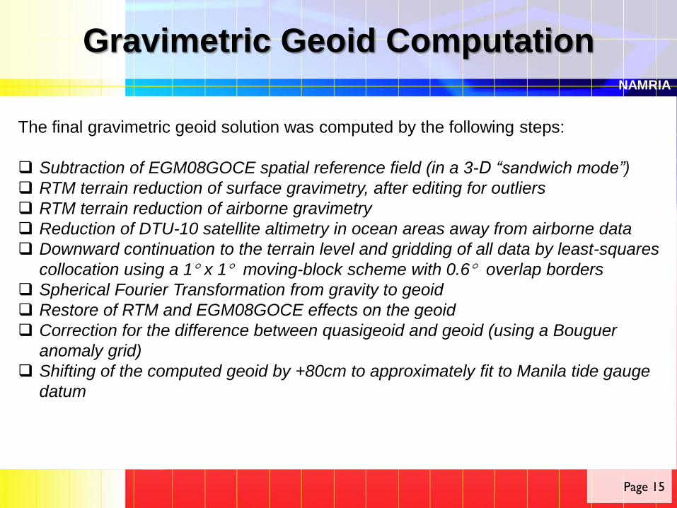
The final gravimetric geoid solution was computed by the following steps:
Subtraction of EGM08GOCE spatial reference field (in a 3-D “sandwich mode”)
RTM terrain reduction of surface gravimetry, after editing for outliers
RTM terrain reduction of airborne gravimetry
Reduction of DTU-10 satellite altimetry in ocean areas away from airborne data
Downward continuation to the terrain level and gridding of all data by least-squares
collocation using a 1 x 1 moving-block scheme with 0.6 overlap borders
Spherical Fourier Transformation from gravity to geoid
Restore of RTM and EGM08GOCE effects on the geoid
Correction for the difference between quasigeoid and geoid (using a Bouguer
anomaly grid)
Shifting of the computed geoid by +80cm to approximately fit to Manila tide gauge
datum

Gravimetric Geoid ComputationNAMRIA
Page 16
The preliminary Philippine
Geoid Model 2014 (PGM2014)
Contour interval 5m

Gravimetric Geoid ComputationPlots of the used and processed data
NAMRIA
Page 17
Low-pass filtered mean elevation surface;
used as reference in RTM terrain
reductions (Elevation in meters)

Gravimetric Geoid ComputationPlots of the used and processed data
NAMRIA
Page 18
NAMRIA land gravity data (1261 points)
and the airborne gravity data after terrain
and EGM-reduction
Some outliers (>50mgal) were deleted in
the geoid processing
1mgal = 0.10mm

Gravimetric Geoid ComputationPlots of the used and processed data
NAMRIA
Page 19
The LS -Collocation downward continued
merged grid

Geoid Processing ResultsIntermediate results
NAMRIA
Page 20
The final geoid covers the region 4-22N, 112-128E, and has a resolution of
0.025 x 0.025 (1.5’ x 1.5’)
The airborne and surface gravity data were gridded by spatial least squares
collocation (gpcol1, using covariance parameters √C0 = 18 mgal, D= 6km,
T=30km)
A priori errors assumed were 2 mGal for both the airborne data and the surface
data (averaged in 0.025 blocks), and 5 mGal for DTU-10. The collocation
downward continuation was done in 1 x 1 blocks, with 0.6 overlaps
For the spherical FFT transformation of gravity to geoid, 3 reference bands were
used
Final geoid restore statistics Unit: meters Mean Std.dev. Min. Max.
Reduced geoid (after spherical FFT) 0.00 0.25 -1.61 2.88
RTM restore effects (computed by
FFT)
0.00 0.04 -0.23 0.74
Final gravimetric geoid statistics 39.06 18.36 -9.02 76.43

Geoid Processing ResultsPrimary data grids
NAMRIA
Page 21
Left: Reduced geoid (after spherical FFT transformation); right: RTM terrain
effect on the geoid

Geoid Processing ResultsPrimary data grids
NAMRIA
Page 22
Bouguer anomaly grid,
derived from the reduced
data
Used for the geoid-
quasigeoid estimation

GNSS data Comparison and Final geoidNAMRIA
Page 23
A set of 190 GNSS data in ITRF2005 levelling
benchmarks was used to compare with the final
geoid (Fitted to GNSS-Leveling to preserve the
existing vertical datum)
These GNSS data showed large errors relative to
the geoid (up to 2m), with large outliers in some
regions likely due to levelling and GNSS errors
The rms fit is 0.5 m; it is therefore not possible to
use these data for validation of the geoid
At right are the offset values and the geoid
correction surface for a fitted geoid, gridded with
80 km correlation length, and GNSS-levelling
apriori error of 10 cm

GNSS data Comparison and Final geoidNAMRIA
Page 24
Differences between the PGM2014
and EGM2008
Large improvements are seen,
especially in the south

Re-computation of the geoid
Part IINAMRIA
Page 25
To improve a geoid model, Professor Forsberg recommended to:
Carefully analyse the levelling network for adjustment errors
Revisit connections and antenna height errors of GNSS data
Erroneous points (geoid outliers) must be resurveyed by gravity,
levelling and GNSS
New GNSS-fitted version of the geoid must be computed as new
batches of GNSS-Levelling data, additional gravity surveys in major
cities and GNSS users height problem reports comes in

Re-computation of the geoidNAMRIA
Page 26
In 2015, the GNSS-levelling data was re-analysed, corrected, and
outliers deleted
Reprocessing of gravity data and Densification of land gravity stations
was conducted in some major cities of the country (2214 points to date)
With the help of Professor Forsberg, NAMRIA started the re-computation
of the Philippine Geoid

Re-computation of the geoidNAMRIA
Page 27
In this re-computation, the airborne and
satellite data processing results were left
as it is. Only the densified land gravity
data were reprocessed and quality
controlled
Figure shows the new plots of the land
and airborne gravity data. Significant
improvements can be seen in the land
data (thicker dots). Most dots are in green
(near zero), some yellows and light blue
(i.e., >25mGals difference in mountainous
regions)

Re-computation of the geoidNAMRIA
Page 28
101 out of the 190 GNSS/Levelling
data on BMs were left after cleaning
up for outliers and use as validation
points. After fitting the new
GNSS/Levelling, the standard
deviation now is 0.054m with a
minimum and maximum offset value of
-0.124m and 0.169m respectively
Figure shows the offset values and the
new geoid correction surface for the
ITRF-fitted PGM2016
More points will be added to the
GNSS/Levelling data as the re-
adjustment of the levelling network
progresses

Re-computation of the geoidNAMRIA
Page 29
The PGM2014 was re-computed
to the new PGM2016 (Figure at
right) using additional land
gravity stations combined with
the same airborne and satellite
gravity data
More land gravity data (up to
41,000) will be added from 2017
until 2020 in order to refine the
Philippine geoid

Re-computation of the geoidNAMRIA
Page 30
Figure shows the differences between
the new PGM2016 and PGM2014
There are N value differences in some
parts of the country as big as 0.30m

NAMRIA
THANK YOU
Salamat Po
Page 31

NAMRIA
Page 14
The latest GOCE spherical harmonic model (“Direct” Release 5 model),
complete to degree and order 280 was used to update EGM08 field in the
following way:
EGM08 used unchanged in spherical harmonic orders 2-80, and from
200 up
GOCE R5 direct model used in band 90-180
A linear blending of the two models done in bands 80-90 and 180-200
The mixed spherical harmonic model (EGM08/GOCE) has been used to
spherical harmonic degree N = 720, corresponding to a resolution of 15’ or
approximately 28km (only 15’ mean gravity data are assumed to be
underlying EGM08)

NAMRIA
Page 15

NAMRIA
Page 16

GNSS data Comparison and Final geoidNAMRIA
Page 29
The PGM2014 files are given as GRAVSOFT grids, and can be
interpolated by the GUI program grid_int
These are provided to NAMRIA as part of the computations, along with
the general software and geoid job setups