PFR for proposed Sand Mining Project of Area 711.0 ha on...
16
PFR for proposed Sand Mining Project of Area 711.0 ha on Son river of District- Bhojpur of State- Bihar Consultant-Ascenso Enviro Pvt. Ltd. Page 1 of 16 PRE-FEASIBILITY REPORT
Transcript of PFR for proposed Sand Mining Project of Area 711.0 ha on...
PFR for proposed Sand Mining Project of Area 711.0 ha on Son river of District- Bhojpur of State-Bihar
Consultant-Ascenso Enviro Pvt. Ltd. Page 1 of 16
PRE-FEASIBILITY REPORT
PFR for proposed Sand Mining Project of Area 711.0 ha on Son river of District- Bhojpur of State-Bihar
Consultant-Ascenso Enviro Pvt. Ltd. Page 2 of 16
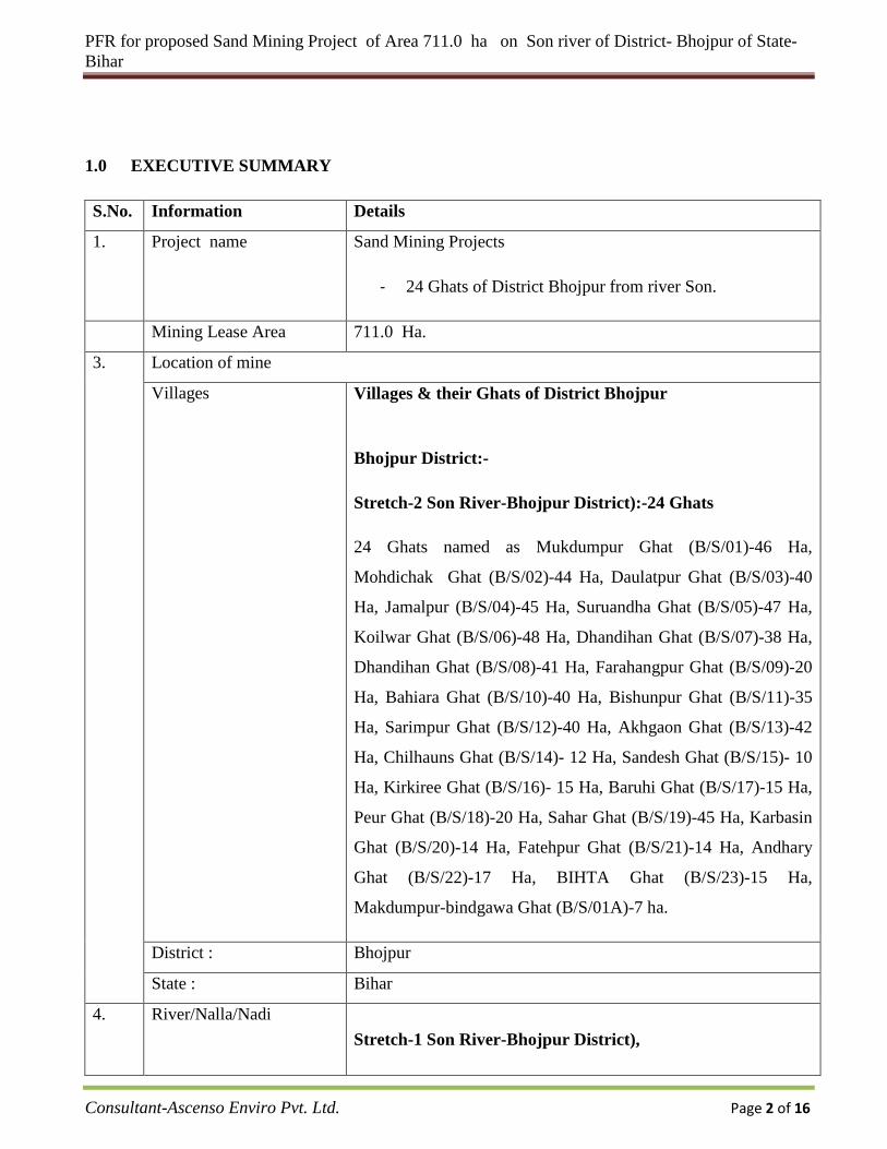
1.0 EXECUTIVE SUMMARY
S.No. Information Details
1. Project name Sand Mining Projects
- 24 Ghats of District Bhojpur from river Son.
Mining Lease Area 711.0 Ha.
3. Location of mine
Villages Villages & their Ghats of District Bhojpur
Bhojpur District:-
Stretch-2 Son River-Bhojpur District):-24 Ghats
24 Ghats named as Mukdumpur Ghat (B/S/01)-46 Ha,
Mohdichak Ghat (B/S/02)-44 Ha, Daulatpur Ghat (B/S/03)-40
Ha, Jamalpur (B/S/04)-45 Ha, Suruandha Ghat (B/S/05)-47 Ha,
Koilwar Ghat (B/S/06)-48 Ha, Dhandihan Ghat (B/S/07)-38 Ha,
Dhandihan Ghat (B/S/08)-41 Ha, Farahangpur Ghat (B/S/09)-20
Ha, Bahiara Ghat (B/S/10)-40 Ha, Bishunpur Ghat (B/S/11)-35
Ha, Sarimpur Ghat (B/S/12)-40 Ha, Akhgaon Ghat (B/S/13)-42
Ha, Chilhauns Ghat (B/S/14)- 12 Ha, Sandesh Ghat (B/S/15)- 10
Ha, Kirkiree Ghat (B/S/16)- 15 Ha, Baruhi Ghat (B/S/17)-15 Ha,
Peur Ghat (B/S/18)-20 Ha, Sahar Ghat (B/S/19)-45 Ha, Karbasin
Ghat (B/S/20)-14 Ha, Fatehpur Ghat (B/S/21)-14 Ha, Andhary
Ghat (B/S/22)-17 Ha, BIHTA Ghat (B/S/23)-15 Ha,
Makdumpur-bindgawa Ghat (B/S/01A)-7 ha.
District : Bhojpur
State : Bihar
4. River/Nalla/Nadi Stretch-1 Son River-Bhojpur District),
PFR for proposed Sand Mining Project of Area 711.0 ha on Son river of District- Bhojpur of State-Bihar
Consultant-Ascenso Enviro Pvt. Ltd. Page 3 of 16
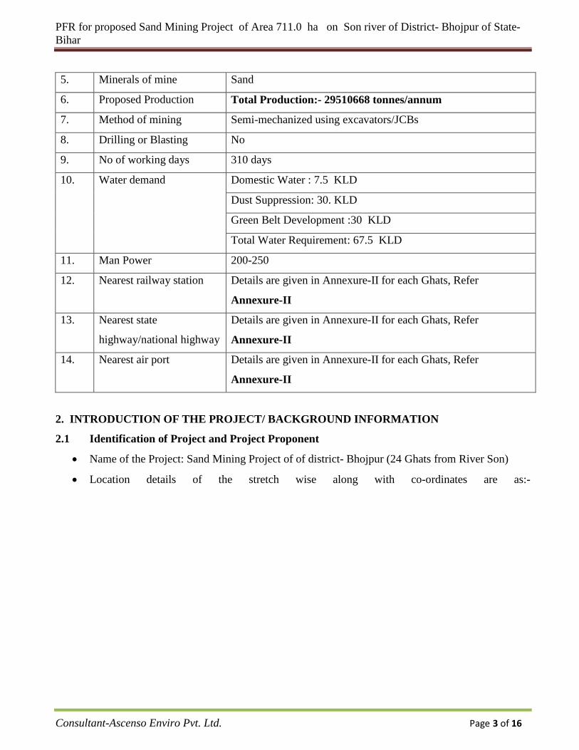
5. Minerals of mine Sand
6. Proposed Production Total Production:- 29510668 tonnes/annum
7. Method of mining Semi-mechanized using excavators/JCBs
8. Drilling or Blasting No
9. No of working days 310 days
10. Water demand Domestic Water : 7.5 KLD
Dust Suppression: 30. KLD
Green Belt Development :30 KLD
Total Water Requirement: 67.5 KLD
11. Man Power 200-250
12. Nearest railway station Details are given in Annexure-II for each Ghats, Refer
Annexure-II
13. Nearest state
highway/national highway
Details are given in Annexure-II for each Ghats, Refer
Annexure-II
14. Nearest air port Details are given in Annexure-II for each Ghats, Refer
Annexure-II
2. INTRODUCTION OF THE PROJECT/ BACKGROUND INFORMATION
2.1 Identification of Project and Project Proponent
• Name of the Project: Sand Mining Project of of district- Bhojpur (24 Ghats from River Son)
• Location details of the stretch wise along with co-ordinates are as:-
PFR for proposed Sand Mining Project of Area 711.0 ha on Son river of District- Bhojpur of State-Bihar
Consultant-Ascenso Enviro Pvt. Ltd. Page 4 of 16
DETAILS OF DISTRICT BHOJPUR ON SON RIVER
SI.No. Distt. Name of river Name of the Ghat Lat (N) Long.(E) Area( Ha.) Geological Reserve in
Tones
Minable reserve in
Tonnes Annual production
B/S/01 BHOJPUR SON MUKDUMPUR
25°39'20.95"N 84°48'29.34"E
46 2663400 2464705 1782044 25°39'6.09"N 84°48'32.67"E 25°39'2.06"N 84°47'59.79"E 25°39'23.06"N 84°48'3.16"E
B/S/02 BHOJPUR SON MOHDICHAK
25°38'29.74"N 84°48'55.33"E
44 2547600 2359194 1887355 25°38'29.81"N 84°48'30.95"E 25°38'8.83"N 84°48'31.07"E 25°38'8.87"N 84°48'55.25"E
B/S/03 BHOJPUR SON DAULATPUR
25°37'44.98"N 84°48'30.54"E
40 2316000 2084400 1875960 25°37'33.63"N 84°48'30.63"E 25°37'33.63"N 84°47'50.06"E 25°37'44.99"N 84°47'50.00"E
B/S/04 BHOJPUR SON JAMALPUR
25°37'14.08"N 84°48'36.45"E
45 2605500 2395283 191622 25°36'59.89"N 84°48'36.26"E 25°36'59.64"N 84°48'6.14"E 25°37'13.87"N 84°47'53.20"E
B/S/05 BHOJPUR SON SURUANDHA
25°35'2.90"N 84°48'38.30"E
47 2721300 2500336 2000269 25°34'44.54"N 84°48'24.72"E 25°34'44.58"N 84°47'59.67"E 25°35'2.99"N 84°48'4.90"E
B/S/06 BHOJPUR SON KOILWAR
25°34'41.87"N 84°48'30.79"E
48 2779200 2580093 2064074 25°34'25.55"N 84°48'32.19"E 25°34'25.10"N 84°47'54.24"E 25°34'41.68"N 84°47'58.46"E
B/S/07 BHOJPUR SON DHANDIHAN
25°33'54.94"N 84°47'28.60"E
38 2200200 2002477 1601982 25°33'47.38"N 84°47'43.02"E 25°33'26.43"N 84°47'17.97"E 25°33'36.11"N 84°47'10.18"E
B/S/08 BHOJPUR SON DHANDIHAN
25°33'15.34"N 84°46'45.61"E
41 2373900 2173514 1738811 25°33'7.62"N 84°46'58.64"E 25°32'49.98"N 84°46'42.90"E 25°33'0.88"N 84°46'24.01"E
B/S/09 BHOJPUR SON FARAHANGPUR
25°32'39.42"N 84°46'30.20"E
20 1158000 1018554 814843 25°32'39.45"N 84°46'12.12"E 25°32'21.86"N 84°46'9.02"E 25°32'21.86"N 84°46'17.76"E
B/S/10 BHOJPUR SON BAHIARA
25°31'47.48"N 84°45'40.26"E
40 2316000 2099021 1679217 25°31'39.48"N 84°46'0.34"E 25°32'15.84"N 84°46'12.18"E 25°32'16.53"N 84°46'5.33"E
PFR for proposed Sand Mining Project of Area 711.0 ha on Son river of District- Bhojpur of State-Bihar
Consultant-Ascenso Enviro Pvt. Ltd. Page 5 of 16
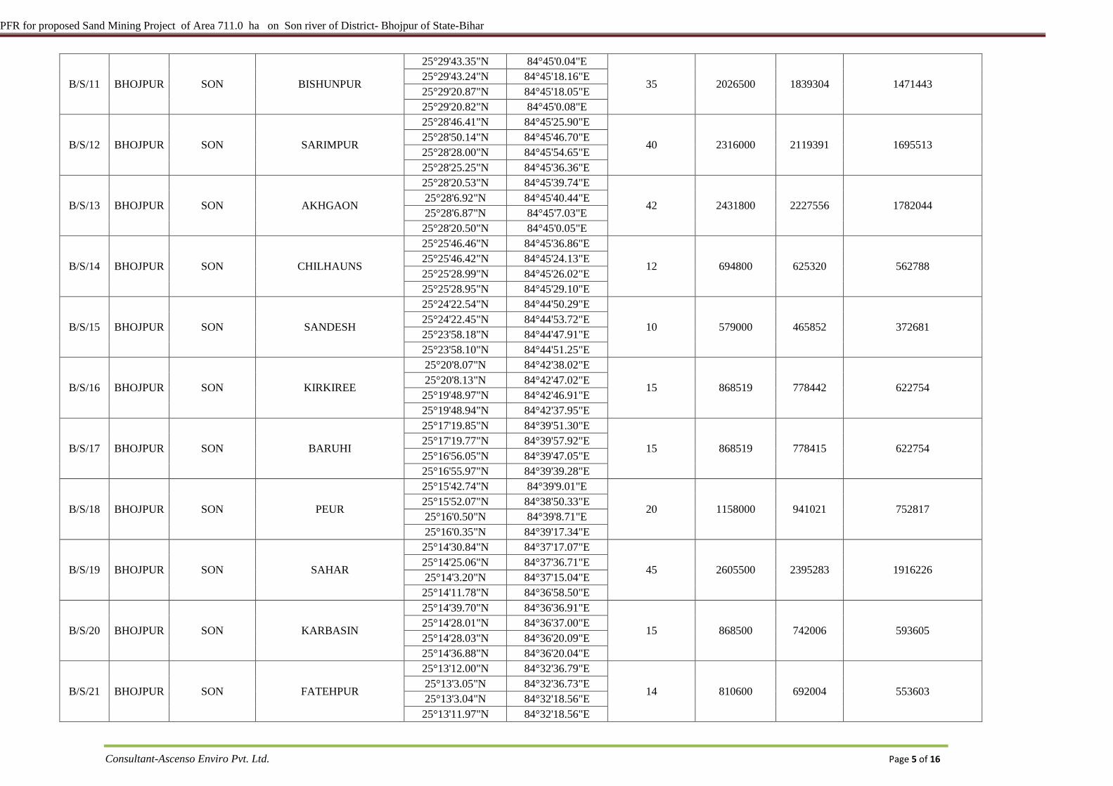
B/S/11 BHOJPUR SON BISHUNPUR
25°29'43.35"N 84°45'0.04"E
35 2026500 1839304 1471443 25°29'43.24"N 84°45'18.16"E 25°29'20.87"N 84°45'18.05"E 25°29'20.82"N 84°45'0.08"E
B/S/12 BHOJPUR SON SARIMPUR
25°28'46.41"N 84°45'25.90"E
40 2316000 2119391 1695513 25°28'50.14"N 84°45'46.70"E 25°28'28.00"N 84°45'54.65"E 25°28'25.25"N 84°45'36.36"E
B/S/13 BHOJPUR SON AKHGAON
25°28'20.53"N 84°45'39.74"E
42 2431800 2227556 1782044 25°28'6.92"N 84°45'40.44"E 25°28'6.87"N 84°45'7.03"E 25°28'20.50"N 84°45'0.05"E
B/S/14 BHOJPUR SON CHILHAUNS
25°25'46.46"N 84°45'36.86"E
12 694800 625320 562788 25°25'46.42"N 84°45'24.13"E 25°25'28.99"N 84°45'26.02"E 25°25'28.95"N 84°45'29.10"E
B/S/15 BHOJPUR SON SANDESH
25°24'22.54"N 84°44'50.29"E
10 579000 465852 372681 25°24'22.45"N 84°44'53.72"E 25°23'58.18"N 84°44'47.91"E 25°23'58.10"N 84°44'51.25"E
B/S/16 BHOJPUR SON KIRKIREE
25°20'8.07"N 84°42'38.02"E
15 868519 778442 622754 25°20'8.13"N 84°42'47.02"E 25°19'48.97"N 84°42'46.91"E 25°19'48.94"N 84°42'37.95"E
B/S/17 BHOJPUR SON BARUHI
25°17'19.85"N 84°39'51.30"E
15 868519 778415 622754 25°17'19.77"N 84°39'57.92"E 25°16'56.05"N 84°39'47.05"E 25°16'55.97"N 84°39'39.28"E
B/S/18 BHOJPUR SON PEUR
25°15'42.74"N 84°39'9.01"E
20 1158000 941021 752817 25°15'52.07"N 84°38'50.33"E 25°16'0.50"N 84°39'8.71"E 25°16'0.35"N 84°39'17.34"E
B/S/19 BHOJPUR SON SAHAR
25°14'30.84"N 84°37'17.07"E
45 2605500 2395283 1916226 25°14'25.06"N 84°37'36.71"E 25°14'3.20"N 84°37'15.04"E 25°14'11.78"N 84°36'58.50"E
B/S/20 BHOJPUR SON KARBASIN
25°14'39.70"N 84°36'36.91"E
15 868500 742006 593605 25°14'28.01"N 84°36'37.00"E 25°14'28.03"N 84°36'20.09"E 25°14'36.88"N 84°36'20.04"E
B/S/21 BHOJPUR SON FATEHPUR
25°13'12.00"N 84°32'36.79"E
14 810600 692004 553603 25°13'3.05"N 84°32'36.73"E 25°13'3.04"N 84°32'18.56"E 25°13'11.97"N 84°32'18.56"E
PFR for proposed Sand Mining Project of Area 711.0 ha on Son river of District- Bhojpur of State-Bihar
Consultant-Ascenso Enviro Pvt. Ltd. Page 6 of 16
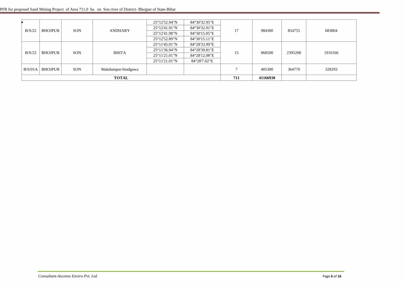
•
B/S/22 BHOJPUR SON ANDHARY
25°12'52.94"N 84°30'32.95"E
17 984300 854755 683804 25°12'41.91"N 84°30'32.91"E 25°12'41.98"N 84°30'15.05"E 25°12'52.89"N 84°30'15.11"E
B/S/23 BHOJPUR SON BIHTA
25°11'45.01"N 84°28'33.99"E
15 868500 2395208 1916166 25°11'36.94"N 84°28'39.81"E 25°11'21.01"N 84°28'12.08"E 25°11'21.01"N 84°28'7.02"E
B/S/01A BHOJPUR SON Makdumpur-bindgawa 7 405300 364770 328293
TOTAL 711 41166938
PFR for proposed Sand Mining Project of Area 711.0 ha on Son river of District- Bhojpur of State-Bihar
Consultant-Ascenso Enviro Pvt. Ltd. Page 7 of 16
Total Production from all the Ghtas of 29510668 tonnes/annum (Semi-Mechanically) Name and address of the Project Proponent: M/s. Broad-son Commodities Pvt. Ltd. Himanshu complex, Bank road, New Koilvar Chouk, District-Bhojpur ( Ara), State-Bihar 2.2 Brief description of nature of the project
The project is open cast mining of minor mineral in the form of Sand. 29510668 tonnes/annum
(Mechanical), Total Production:- 29510668 tonnes/annum .Sand will be excavated. Entire process of
excavation will be semi-mechanized.
The project has been proposed by M/s. Broad-son Commodities Pvt. Ltd.. The project proponent had
obtained mining permission for District- Bhojpur, attached as Annexure-I.
2.3 Need for the Project and Its Importance to the Country or Region
Sand is used widely in the construction industry. It is mixed with cement and other ingredients to create
mortar for building. It is also used in agriculture, as sandy soils are ideal for crops such as watermelons,
peaches and peanuts. Sand is also used in Aquaria as it makes a low cost aquarium base material.
2.4 Demands-Supply Gap
Creation of huge infrastructure as being envisaged by Government of India particularly in road and
housing sector requires basic building raw materials. Thus the demand for Sand is ever growing with
the growth of the infrastructure sector in our country. The requirement for the mineral is always high in
the nearby cities and towns. Therefore there is always a good demand of the mineral in the domestic
market.
2.5 Imports vs. Indigenous Production
The demand in the domestic market is high for Sand. Mineral is available in abundant quantity in
allotted area and can be excavated indigenously. Vast quantities of sand are available in river ghats..
Therefore import of sand is not required.
PFR for proposed Sand Mining Project of Area 711.0 ha on Son river of District- Bhojpur of State-Bihar
Consultant-Ascenso Enviro Pvt. Ltd. Page 8 of 16
2.6 Export Possibility
There is no proposal to export the mineral as the minerals excavated, cater to the indigenous demand
and the development is a never ending process.
2.7 Domestic/ Export Markets
a) DOMESTIC MARKET
There is always an ever increasing demand of these minerals in the domestic market.
b) EXPORT MARKET
The proposed mining activity is for indigenous consumption only for real state, road making etc. So no
export will be envisaged.
2.8 Employment Generation (Direct and indirect) due to the project
The total direct manpower requirement for the proposed mining operation will be around 200-250.
Indirect employment is also expected due to the associated activities.
3 PROJECT DESCRIPTION
3.1 Type of Project Including Interlinked and Interdependent Projects, If Any.
The proposed project for excavation of Sand is an independent project in which minerals excavated will
be directly sold in the local markets. It does not involve interlinked and interdependent project.
3.2 Location
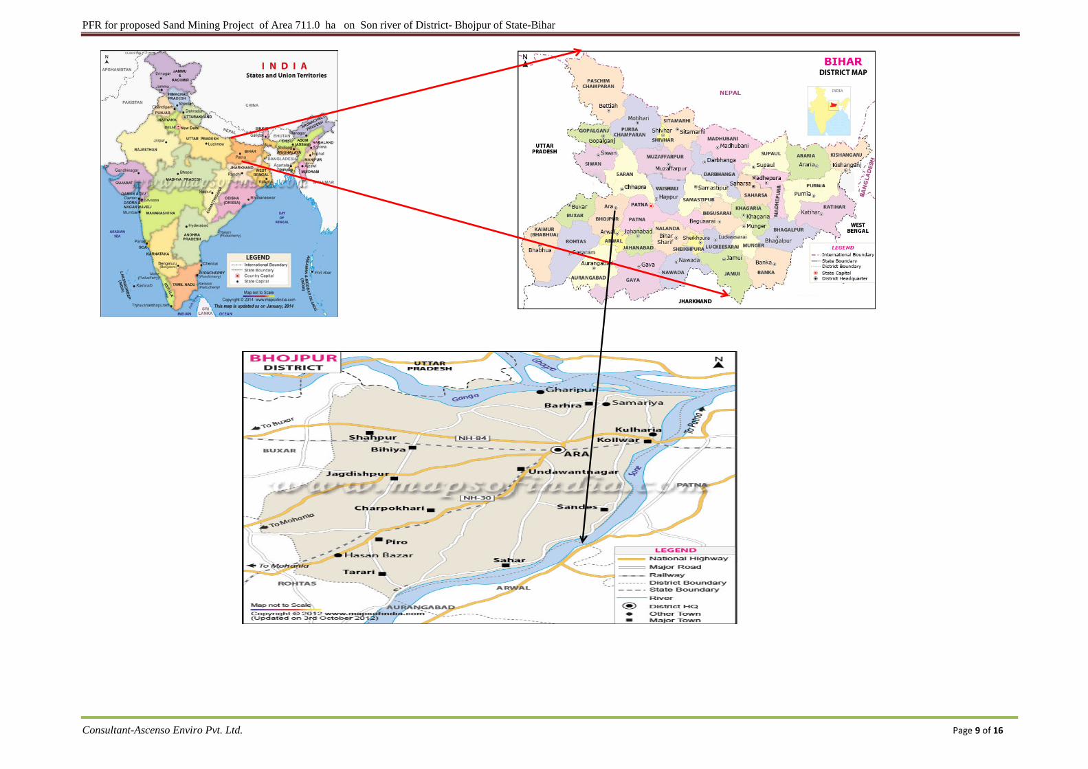
The mining lease area is located on 106 Ghats of different rivers of District- Bhojpur of State-Bihar.
Composite map showing project sites is attached as Annexure III. The vicinity map of the mine
location is given below:
PFR for proposed Sand Mining Project of Area 711.0 ha on Son river of District- Bhojpur of State-Bihar
Consultant-Ascenso Enviro Pvt. Ltd. Page 9 of 16
PFR for proposed Sand Mining Project of Area 711.0 ha on Son river of District- Bhojpur of State-Bihar
Consultant-Ascenso Enviro Pvt. Ltd. Page 10 of 16
3.3 Details of alternate sites considered and the basis of selecting the proposed site,
Particularly the environment considerations gone into should be highlighted.
Mineral location is site specific as well as the lease has been allotted in the particular sand bearing area.
Hence no alternative site is examined for mining. The land has been allocated by government for the
mining only. As there is potential of Sand in large amount, so the mining will help to use a resource for
beneficial purposes.
3.4 Size or magnitude of operation
The proposed mine has lease over an area of 711.0 ha. The maximum rated capacity of the project will
Approx. Total Production – 29510668 tonnes/annum mechanically.
3.5 Project description with process details
This is an open-cast mining project, confined to excavation of Sand from the proposed site. The
operation will be semi-mechanized using Excavators/JCB .The mineral- sand will be collected in its
existing form. Excavation will be carried out only up to a depth of 3 m (Maximum) below ground level
or above water level, whichever is less. Excavation of Sand material will be done only during the day
time and completely stopped during the monsoon season.
3.6 Raw Material Required Along With Estimated Quantity, Likely Source, Marketing Area
of Final Product/s, Mode of Transport of Raw Material and Finished Product
No raw material will be required in the proposed project. The operation involves only the excavation of
Sand in its existing form and transported to the end users/ market.
3.7 RESOURCE OPTIMIZATION/ RECYCLING AND REUSE
Minerals are generally depleting asset once mined; but minerals like Sand will be replenished naturally.
Thus a scientific approach will be taken up for excavation of mineral with systematic method.
3.8 AVAILABILITY OF WATER, ITS SOURCE, ENERGY/ POWER REQUIREMENT
AND SOURCE
3.8.1 Water Requirement
Activity Water requirement (KLD) Dust suppression 30
Domestic 7.5
Green Belt Development 30
PFR for proposed Sand Mining Project of Area 711.0 ha on Son river of District- Bhojpur of State-Bihar
Consultant-Ascenso Enviro Pvt. Ltd. Page 11 of 16
Total 67.5
Thus total water requirement will be 67.5 KLD. This water will be supplied from private tankers.
3.8.2 POWER
All the activities will be carried out using diesel based machines. The material will be excavated and
loaded directly into tractors by the workers themselves. The operation will be done only from sun rise to
sun set. So there is no power requirement for the mining activity.
3.9 QUANTITY OF WASTES TO BE GENERATED (LIQUID AND SOLID) AND
SCHEME FOR THEIR MANAGEMENT/ DISPOSAL
3.9.1 Solid Waste Generation & its Disposal
Only bio-degradable solid waste will be generated.
3.9.2 Liquid Effluent
Portable Bio-Toilet shall be provided for the workers at the site. The sewage generated from the toilet
provided for the mine workers shall be collected and treated by the inbuilt process of DRDO patented
Bio technology using specially cultured anaerobic bacteria
4 SITE ANALYSIS
4.1 Connectivity
Refer Annexure II for connectivity details of each Ghats.
4.2 LANDFORM, LANDUSE AND LAND OWNERSHIP
The proposed activity is to take place in the river bed of Son river. The land form is mostly river bed
and non-forest land. The entire land is Government land.
Moreover there will be no change in land use as the mining will be confined to the river bed, which will
get replenished naturally with the continuous flow of water.
4.3 TOPOGRAPHY
The topography of study area is fluvial in origin. It is developed by the silt deposited by river Son, &
Gandak both are major tributary of River Ganga. Gandak mixes with Ganga from north direction while
son mixes from south direction. Eastern embankment of Son River is relatively higher than western
side. Major alluvial features including Pond, Riverine Island, Marsh Land, Large Sand Marsh etc. other
important smaller drainage include Punpun river, Pachanua Nadi, Banas Nadi, Dhoi Nadi, Morhar Nadi,
Dardha Nadi, Siroka Nadi, Kumhari Nadi etc. The major man made drainages include Jamrohi
distributary, Karath distributary, Sakla Distributary, Amauna Distributary, Ara Canal, Gaharuan
Distributary, Sikraut Distributary, Garhan subdistributary, Jaitpur Distributary, Panwar Distributary,
PFR for proposed Sand Mining Project of Area 711.0 ha on Son river of District- Bhojpur of State-Bihar
Consultant-Ascenso Enviro Pvt. Ltd. Page 12 of 16
Kuri Distributary, Koilwar Distributary, Bichhiaon Distributary, Asni Distributary, Danapur
Distributary, Patna Distributary, Kurkuri Distributary, Dariyapur Distributary, Murka Distributary,
Paliganj Distributary, Adampur Distributary, Patna Canal, Rewa Distributary, Manjhauli Distributary,
Fatehpur Distributary, Katea Distributary, Kakila Distributary, Lathan Distributary, Tar Distributary,
etc. Almost each and every village is having its pond. General slope pattern is from South-West to
North-East in Son flood plain while from North-west to south east in Gandak Plain.
4.4 EXISTING LAND USE PATTERN AND SHORTEST DISTANCES FROM FORESTS,
WATER BODIES, ECO-SENSITIVE AREAS, ETC.
The mine lease area is flat. There is no forest land or agriculture land in the mine lease area. The entire
mining lease lies within the inactive channel of the bed of Son river, The existing land use pattern is
dominated by agriculture which is followed by forests and barren land. The detailed land use pattern
will be studied during baseline study.
4.5 EXISTING INFRASTRUCTURE
The site has no existing infrastructure, except for connecting road for transportation.
4.6 SOIL CLASSIFICATION
The farming situations in the district are mainly dependent as soil, topography and irrigation systems prevalent in the area. The district has mainly four types of soils ranging from moderately well drained to poorly drained, acidic to slightly alkaline and medium to heavy textured. From the farming point of view only four types of soils may be recognized as light to heavy in texture.
4.7 CLIMATIC DATA FROM SECONDARY SOURCES
The district by and large is homogenous. It is of moderate type characterized by quite hot summers
to moderately cold winters. The day temperature generally ranges from 21.1 ºC in January to 38.7
ºC in May and night temperature from 7.3 ºC in December to 27.7 ºC in June. The summer begins in
April and peaks in June/July with the temperature soaring up to 43 °C till the moisture laden
monsoon wind bring some much-needed relief to the parched fields. The rains last through August
& September and continue into early October.
The normal annual rainfall in the district is around 1076 mm. The timely and well-distributed rainfall
during Kharif and Rabi has a deciding influence on the land use and cropping pattern of the district.
PFR for proposed Sand Mining Project of Area 711.0 ha on Son river of District- Bhojpur of State-Bihar
Consultant-Ascenso Enviro Pvt. Ltd. Page 13 of 16
4.8 SOCIAL INFRASTRUCTURE AVAILABLE
Mine lease area is within 10-15 Km from their respective towns. Detail of Social Infrastructure for each
ghat attached in Annexure II.
5 PLANNING BRIEF
5.1 Planning Concept
Mining will be done as per the guidelines of Bihar Mineral Policy, and guidelines of Bihar Minor
Mineral Concession Rules (amended thereof)
This is an open-cast mining project. Excavation of minerals will be carried out only up to a depth of 3
meter and 5 meter of safety zone will be left all around the lease area. Thus the lease area falling within
this stability zone will be left as no mining area.
5.2 Population projection
The project will employ most of the workers from nearby villages except for supervisory staff. Thus
there will no increase in population due to the project. However, few people from other area may
migrate in this area for employment directly and indirectly for business opportunities.
Population projection as per last three decades population growth rate and addition in the existing
population by the proposed project will be included in final EIA.
5.3 Land use planning (Break up along with green belt, etc.)
Mining will be done in slices starting from the topmost level progressively advancing downwards. The
area so excavated will get filled up due to sediment inflow during monsoon.
Plantation will be done near the civic amenities or road sides in consultation with the local
authorities/Government body. It is not feasible to plant trees in the lease area. Native plant / tree
species will be planted in consultation with gram panchayat and local forest officials..
5.4 Assessment of Infrastructure Demand (Physical & Social)
Infrastructure like evacuation road, site services will only be required. Only local villagers from nearby
villages will be employed for the mining activity. Thus no housing facility is proposed.
5.5 Amenities/Facilities
The following facilities/amenities will be extended by the mine management:
• Direct and indirect Employment, most of which most will be from nearby villages depending
upon the suitability of persons required for the job.
PFR for proposed Sand Mining Project of Area 711.0 ha on Son river of District- Bhojpur of State-Bihar
Consultant-Ascenso Enviro Pvt. Ltd. Page 14 of 16
• Arrangements for safe and healthy working conditions & temporary rest shelters.
• Provision of Drinking water.
• Provision of PPE.
• First-Aid facilities and Health check-up camps for the workers.
• Conducting medical camps for workers and nearby villagers at regular interval.
6 PROPOSED INFRASTRUCTURE
6.1 Industrial Area (Processing Area)
No industrial area is proposed.
6.2 Residential Area (Non Processing Area)
As the local people will be given employment, no residential area/ housing are proposed.
6.3 Green Belt
It is proposed to plant local trees and bushes along the river banks and along haul road in consultation
with the local authority/ Govt. body.
6.4 Social infrastructure
• Road facility (existing roads will be maintained regularly) • Employment opportunity • Medical camps • Social awareness camps, • Donations to schools • Secondary employment opportunities • Formation of self-help groups for the women in nearby villages
6.5 Connectivity
Lease area is well connected to an un-metalled road which further joins the respective metaled roads.
Details of connectivity from each Ghats are given in Annexure II.
6.6 Drinking Water Management
Water required for drinking purpose will be obtained through tankers/or by private tankers. 6.7 Sewerage System
Portable Bio-Toilet shall be provided for the workers at the site. The sewage generated from the toilet provided for the mine workers shall be collected and treated by the inbuilt process of DRDO patented Bio technology using specially cultured anaerobic bacteria
PFR for proposed Sand Mining Project of Area 711.0 ha on Son river of District- Bhojpur of State-Bihar
Consultant-Ascenso Enviro Pvt. Ltd. Page 15 of 16
6.8 Industrial Waste Management
Not applicabl
6.9 Solid Waste management
Only bio- degradable solid waste will be generated.
6.10 Power Requirement & Supply/Source.
All the activities will be carried out using diesel based machines. The material will be excavated and
loaded directly into tractors by the workers themselves. The operation will be done only from sun rise to
sun set. So there is no power requirement for the mining activity.
7 REHABILITATION AND RESETTLEMENT (R&R) PLAN
The mine area is inactive channel of river bed, so rehabilitation and resettlement plan is not required
8 PROJECT SCHEDULE & COST ESTIMATES
8.1 Likely date of start of construction and likely date of completion.
The project will commence once Environmental Clearance and other necessary certificates are obtained
from the respective departments.
8.2 Estimated project cost along with analysis in terms of economic viability of the project
Sr. No. Description Cost in Crores
1 Cost of infrastructure, vehicles, Manpower & site amenities etc.
1.5
2 Equipment’s & Machineries 1.5.
3 Site amenities 0.5
4 Environnemental Protection 1.0
5 Miscellaneous 0.5
TOTAL Rs. 5.0 Crores
The total cost of project would be around Rs. 5.0 crores
9.0 ANALYSIS OF PROPOSAL (FINAL RECOMMENDATIONS)
The Project will bring economic benefits to the state by the way of Royalty for mineral.
Achieving a huge infrastructure as being envisaged by Government of India particularly in road and
housing sector requires basic building materials. Sand is one of primary building material required for
PFR for proposed Sand Mining Project of Area 711.0 ha on Son river of District- Bhojpur of State-Bihar
Consultant-Ascenso Enviro Pvt. Ltd. Page 16 of 16
the purpose. The mining activities as proposed are the backbone of all construction and infrastructure
projects as the raw material for construction is available only from such mining. Sand excavated is in
high demand at the local market for real estate industry.
This project operation will provide livelihood to the poorest section of the society/economically
backward population and tribal in the area. It provides employment to the people residing in vicinity
directly or indirectly. The mine management will also help nearby villages by providing aid to school,
conducting medical and social awareness camps, helping in formation of self-help groups, etc. Thus the
project will bring about socio-economic improvement of the area and will prove beneficial to the area.
**********