Pfizer Sites Rezoning - Welcome to NYC.gov · Pfizer Sites Rezoning ... The EIS will consider the...
50
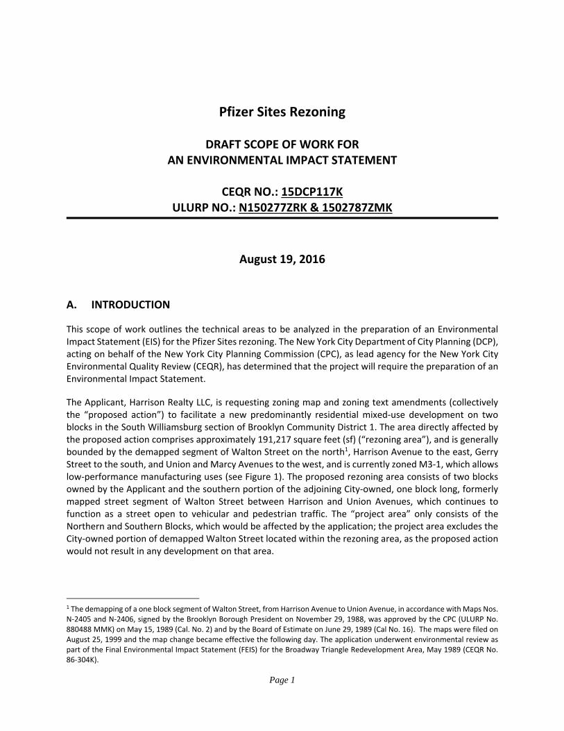
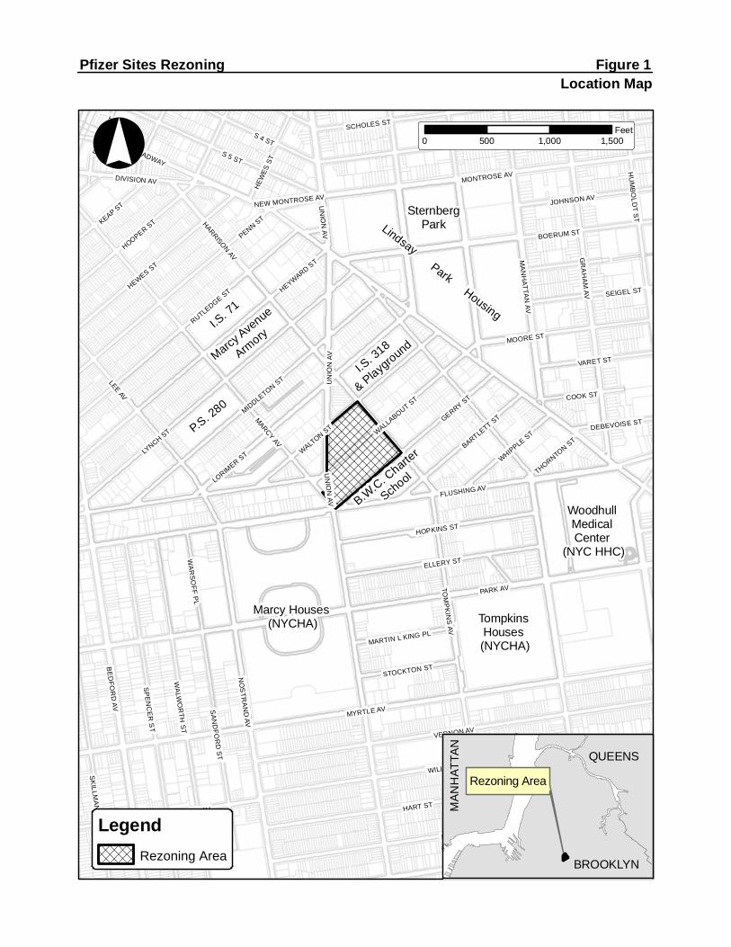
Page 1 Pfizer Sites Rezoning DRAFT SCOPE OF WORK FOR AN ENVIRONMENTAL IMPACT STATEMENT CEQR NO.: 15DCP117K ULURP NO.: N150277ZRK & 1502787ZMK August 19, 2016 A. INTRODUCTION This scope of work outlines the technical areas to be analyzed in the preparation of an Environmental Impact Statement (EIS) for the Pfizer Sites rezoning. The New York City Department of City Planning (DCP), acting on behalf of the New York City Planning Commission (CPC), as lead agency for the New York City Environmental Quality Review (CEQR), has determined that the project will require the preparation of an Environmental Impact Statement. The Applicant, Harrison Realty LLC, is requesting zoning map and zoning text amendments (collectively the “proposed action”) to facilitate a new predominantly residential mixed‐use development on two blocks in the South Williamsburg section of Brooklyn Community District 1. The area directly affected by the proposed action comprises approximately 191,217 square feet (sf) (“rezoning area”), and is generally bounded by the demapped segment of Walton Street on the north 1 , Harrison Avenue to the east, Gerry Street to the south, and Union and Marcy Avenues to the west, and is currently zoned M3‐1, which allows low‐performance manufacturing uses (see Figure 1). The proposed rezoning area consists of two blocks owned by the Applicant and the southern portion of the adjoining City‐owned, one block long, formerly mapped street segment of Walton Street between Harrison and Union Avenues, which continues to function as a street open to vehicular and pedestrian traffic. The “project area” only consists of the Northern and Southern Blocks, which would be affected by the application; the project area excludes the City‐owned portion of demapped Walton Street located within the rezoning area, as the proposed action would not result in any development on that area. 1 The demapping of a one block segment of Walton Street, from Harrison Avenue to Union Avenue, in accordance with Maps Nos. N‐2405 and N‐2406, signed by the Brooklyn Borough President on November 29, 1988, was approved by the CPC (ULURP No. 880488 MMK) on May 15, 1989 (Cal. No. 2) and by the Board of Estimate on June 29, 1989 (Cal No. 16). The maps were filed on August 25, 1999 and the map change became effective the following day. The application underwent environmental review as part of the Final Environmental Impact Statement (FEIS) for the Broadway Triangle Redevelopment Area, May 1989 (CEQR No. 86‐304K).
Transcript of Pfizer Sites Rezoning - Welcome to NYC.gov · Pfizer Sites Rezoning ... The EIS will consider the...
Page 1
Pfizer Sites Rezoning
DRAFT SCOPE OF WORK FOR AN ENVIRONMENTAL IMPACT STATEMENT
CEQR NO.: 15DCP117K ULURP NO.: N150277ZRK & 1502787ZMK
August 19, 2016
A. INTRODUCTION
This scope of work outlines the technical areas to be analyzed in the preparation of an Environmental Impact Statement (EIS) for the Pfizer Sites rezoning. The New York City Department of City Planning (DCP), acting on behalf of the New York City Planning Commission (CPC), as lead agency for the New York City Environmental Quality Review (CEQR), has determined that the project will require the preparation of an Environmental Impact Statement.
The Applicant, Harrison Realty LLC, is requesting zoning map and zoning text amendments (collectively the “proposed action”) to facilitate a new predominantly residential mixed‐use development on two blocks in the South Williamsburg section of Brooklyn Community District 1. The area directly affected by the proposed action comprises approximately 191,217 square feet (sf) (“rezoning area”), and is generally bounded by the demapped segment of Walton Street on the north1, Harrison Avenue to the east, Gerry Street to the south, and Union and Marcy Avenues to the west, and is currently zoned M3‐1, which allows low‐performance manufacturing uses (see Figure 1). The proposed rezoning area consists of two blocks owned by the Applicant and the southern portion of the adjoining City‐owned, one block long, formerly mapped street segment of Walton Street between Harrison and Union Avenues, which continues to function as a street open to vehicular and pedestrian traffic. The “project area” only consists of the Northern and Southern Blocks, which would be affected by the application; the project area excludes the City‐owned portion of demapped Walton Street located within the rezoning area, as the proposed action would not result in any development on that area.
1 The demapping of a one block segment of Walton Street, from Harrison Avenue to Union Avenue, in accordance with Maps Nos. N‐2405 and N‐2406, signed by the Brooklyn Borough President on November 29, 1988, was approved by the CPC (ULURP No. 880488 MMK) on May 15, 1989 (Cal. No. 2) and by the Board of Estimate on June 29, 1989 (Cal No. 16). The maps were filed on August 25, 1999 and the map change became effective the following day. The application underwent environmental review as part of the Final Environmental Impact Statement (FEIS) for the Broadway Triangle Redevelopment Area, May 1989 (CEQR No. 86‐304K).
TompkinsHouses(NYCHA)
Marcy Houses(NYCHA)
P.S. 280
I.S. 71
MarcyAve
nue
Armory
I.S. 318
& Playground
SternbergPark
WoodhullMedicalCenter
(NYC HHC)
B.W.C. Charte
r
School
ParkHousing
Lindsay
MARCYAV
PARK AV
THR
OO
PAV
MYRTLE AV
FLUSHING AV
HART ST
LYNCH ST
LORIMER
ST
VERNON AV
PULASKI ST
BE
DFO
RD
AVLEE
AV
S 5 ST
HARRISONAV G
RA
HA
MAV
TOM
PK
INS
AV
WALLABOUT ST
PENN ST
SP
EN
CE
RS
T
BOERUM ST
NO
STR
AN
DAV
WILLOUGHBY AV
HEYWARD ST
DE KALB AV
MESEROLE ST
WA
LWO
RTH
ST
MONTROSE AV
MIDDLETON
ST UN
ION
AVRUTLEDGE ST
WALTON
ST
MA
NH
ATTAN
AV
GERRY ST
HOOPER ST
HEWES ST
ELLERY ST
S 4 ST
MOORE ST
KEAP ST
HOPKINS ST
SK
ILLMA
NS
T
HU
MB
OLD
TS
T
SA
ND
FOR
DS
T
SCHOLES ST
BARTLETT ST
SEIGEL ST
VARET ST
BROADWAY
JOHNSON AV
COOK ST
DIVISION AV
WHIPPLE ST
WA
RS
OFF
PL
RO
DN
EY
ST
STOCKTON ST
MARTIN L KING PL
DEBEVOISE ST
THORNTONST
NEW MONTROSE AV
HEW
ESST
UN
ION
AV
WILLOUGHBY AV
UN
ION
AV
°
Pfizer Sites Rezoning Figure 1Location Map
Legend
0 500 1,000 1,500Feet
Rezoning Area
BROOKLYN
QUEENS
MA
NH
TATA
N
Rezoning Area

Pfizer Sites Rezoning Draft Scope of Work for an EIS
Page 2
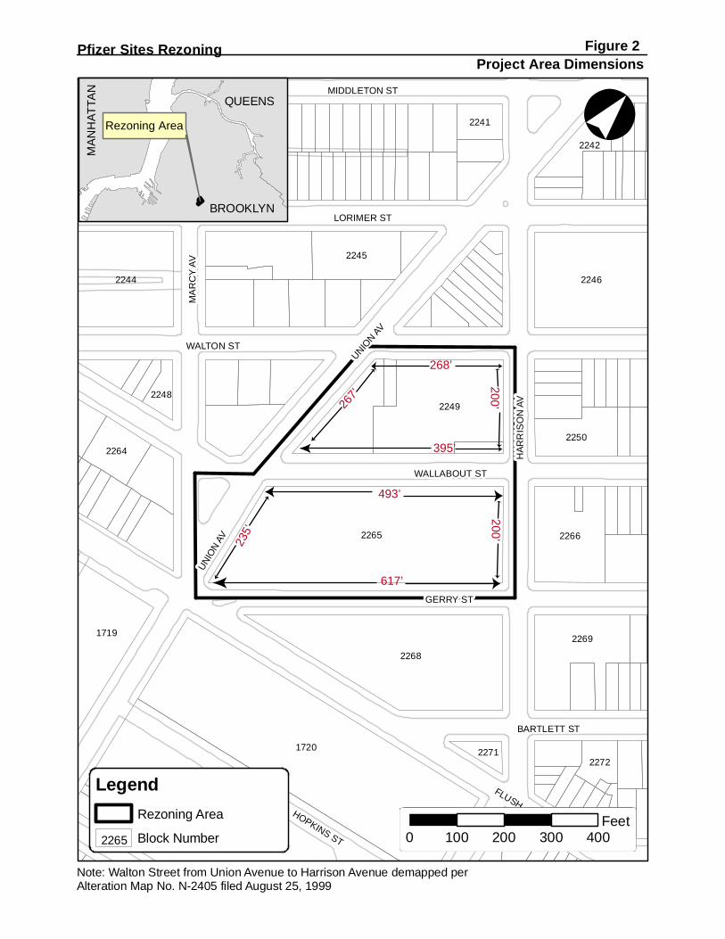
The two blocks owned by the Applicant consist of a 71,322 sf “Northern Block” (Block 2249, Lots 23, 37, 41, and 122), bounded by the demapped segment of Walton Street, Harrison Street, Wallabout Street, and Union Avenue, and the 111,044‐sf “Southern Block” (Block 2265, Lot 14) bounded by Wallabout Street, Harrison Street, Gerry Street, and Union Avenue (combined comprised the “project area”).
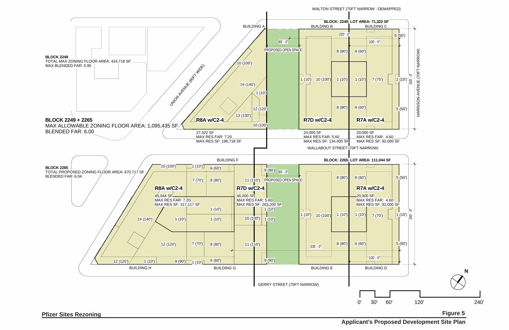
The proposed action would rezone the current M3‐1 zoning district to R7A, R7D, and R8A, and would have a C2‐4 commercial overlay on the entire Northern and Southern Blocks. As a result, both blocks would be split into R7A/C2‐4, R7D/C2‐4, and R8A/C2‐4 districts. An R7A district would be mapped for the portion within 100 feet of Harrison Avenue. An R7D district would be mapped for the portion more than 100 feet from Harrison Avenue and including the areas extending up to 335 feet from Harrison Avenue on the Southern Block and up to 220 feet from Harrison Avenue on the Northern Block. An R8A district would be mapped for the portion more than 335 feet from Harrison Avenue on the Southern Block and more than 220 feet from Harrison Avenue on the Northern Block. In addition, a C2‐4 commercial overlay would be mapped over the underlying districts, covering the entirety of the Northern and Southern Blocks. The proposed zoning text amendment to Appendix F of the Zoning Resolution would designate the rezoning area as a Mandatory Inclusionary Housing Area (MIHA), which would require a share of residential floor area be provided as affordable housing pursuant to the MIH program. Pursuant to the proposed zoning and MIH designation, the Applicant intends to develop housing and local retail and a 26,000‐sf privately‐owned, publicly‐accessible open space on these blocks. The open space would be provided pursuant to a legal instrument such as a Restrictive Declaration (RD) recorded against the property. As identified in the Land Use Review application, pursuant to the proposed action, the Applicant proposes to develop the project area with a development program consisting of 1,146 DUs, of which at least 287 DUs, occupying 25 percent of the floor area excluding non‐residential ground floor space, would be inclusionary housing affordable units, and 64,807 gsf of local retail space. The development would be required to provide 405 accessory parking spaces. The Applicant’s development would also include 26,000 sf of publicly‐accessible open space, provided in midblock corridors on each block measuring 65 feet wide by 200 feet long and aligned on a north‐south axis parallel to Harrison Avenue. The Applicant’s development would consist of eight buildings featuring streetwalls and setbacks, reaching a maximum height of 140 feet (14 stories). As discussed below, RWCDS With‐Actions conditions would be nearly identical to the Applicant’s proposed development, with only two relatively minor differences: (1) residential program; and 2) building heights. The Applicant’s development would have 1,146 DUs, instead of 1,147 DUs, the share of affordable housing would be 25 percent instead of 30 percent, and as a result of those changes, the accessory parking for the Applicant’s development would be 405 spaces instead of 427. The Applicant’s development program would have a maximum building height of 140 feet, as compared to 145 feet for the RWCDS. This is due to the RWCDS providing qualifying ground floor uses that allow maximum building heights to be 5 feet taller than otherwise permitted (the Applicant’s development would not meet the qualifying ground floor criteria). The retail and publicly‐accessible open space programs in the Applicant’s development would be the same under the RWCDS. The EIS will consider the reasonable worst‐case development scenario (RWCDS) for the proposed action; as noted above there are minor differences between the Applicant’s proposed development and the RWCDS. The environmental review will consider that the Applicant would develop up to approximately 1,147 dwelling units (DUs), of which approximately 803 DUs would be market rate units and 343 DUs (occupying 30 percent of the total floor area, exclusive of ground floor non‐residential floor area per Zoning Resolution (ZR) Section 23‐952) would be affordable housing units, with approximately 64,807 gsf

Pfizer Sites Rezoning Draft Scope of Work for an EIS
Page 3
of local retail space and 427 accessory self‐park parking spaces on two blocks. As a condition for allowing a change in use for the project area, the development would include 26,000 sf (0.60 acres) of dedicated publicly‐accessible open space, in a 65‐foot wide, midblock linear corridor with 13,000 sf on each block. The RWCDS With‐Action would consist of eight buildings featuring streetwalls and setbacks, reaching a maximum height of 145 feet (14 stories). This document provides a description of and the need and purpose for the proposed action, the resulting projected development and includes task categories for all technical areas to be analyzed in the EIS.
B. REQUIRED PUBLIC APPROVALS AND REVIEW PROCEDURES The Applicant is seeking two City Planning Commission (CPC) actions, a zoning map amendment and a zoning text amendment, which collectively define the “proposed action”.
(1) Zoning map amendment, pursuant to ZR 71‐10, to
Replace an existing M3‐1 low‐performance manufacturing zoning district with R7A, R7D and R8A contextual residential zoning districts for an approximately 191,217 sf area; and
Map new C2‐4 commercial overlays on the entire rezoning area.
(2) Zoning text amendment, pursuant to ZR 23‐933, to amend Appendix F of the Zoning Resolution (ZR) to apply the Mandatory Inclusionary Housing program to the proposed rezoning area in Brooklyn Community District 1, Map 4.
Both of these are discretionary actions; the zoning map amendment is subject to the Uniform Land Use Review Procedure (ULURP) and the zoning text amendment is subject to public review with requirements similar to ULURP. These actions are subject to environmental review under the State Environmental Quality Review Act (“SEQRA”) and the City Environmental Quality Review (“CEQR”).
City Environmental Quality Review (CEQR) and Scoping
The proposed action requires environmental review pursuant to CEQR procedures. An Environmental Assessment Statement (EAS) was completed on August 19, 2016. The New York City Department of City Planning (NYCDCP), acting as lead agency on behalf of the City Planning Commission (CPC), determined that the proposed action may potentially result in significant adverse environmental impacts, thus requiring that an EIS be prepared.
The CEQR scoping process is intended to focus the EIS on those issues that are most pertinent to the proposed action. The process also allows other agencies and the public a voice in framing the scope of the EIS. This scoping document sets forth the analyses and methodologies which will be utilized to prepare the EIS. During the period for scoping, those interested in reviewing the Draft Scope may do so and give their comments to the lead agency. The public, interested agencies, Brooklyn Community Board 1, and elected officials are invited to comment on the Draft Scope, either in writing or orally, at a public scoping session to be held on Wednesday, September 21, 2016 at 6:00 PM at Intermediate School 318, 101 Walton Street, Brooklyn, NY 11206. Comments received during the public scoping session, and written comments received up to 10 days after the session (until 5:00 P.M. on Wednesday, October 5, 2016), will be considered and incorporated as appropriate into a final scope of work. The lead agency will oversee

Pfizer Sites Rezoning Draft Scope of Work for an EIS
Page 4
preparation of a Final Scope of Work, which will revise the extent or methodologies of the studies, as appropriate, in response to comments made during scoping. The draft EIS (DEIS) will be prepared in accordance with the Final Scope of Work for an EIS.
Once the lead agency is satisfied that the DEIS is complete, the document will be made available for public review and comment. It is anticipated that the DEIS will accompany the land use application for the zoning map and text amendments. Publication of the DEIS and issuance of the Notice of Completion signal the start of the public review period. During this time the public may review and comment on the DEIS, either in writing and/or at a public hearing that is convened for the purpose of receiving such comments. A public hearing will be held on the DEIS to afford all interested parties the opportunity to submit oral and written comments. The record will remain open until Wednesday, October 5, 2016, to allow additional written comments on the DEIS. At the close of the public review period, a Final EIS (FEIS) will be prepared that will incorporate all substantive comments made on the DEIS, along with any revisions to the technical analysis necessary to respond to those comments. The FEIS will then be used by the decision makers to evaluate project impacts and proposed mitigation measures before deciding whether to approve, modify or disapprove the requested discretionary actions.
C. DESCRIPTION OF PROPOSED ACTION
Existing Conditions Rezoning Area As described previously, the 191,217 sf rezoning area includes two blocks owned by the Applicant (project area) and the southern portion of an adjoining City‐owned one block long formerly mapped street segment in the southeastern portion of Brooklyn Community District 1. Table 1 summarizes existing conditions in the proposed rezoning area. The 71,322‐sf Northern Block has approximately 200 feet of frontage along Harrison Avenue, approximately 445 feet of frontage along Wallabout Street, approximately 267 feet of frontage along Union Avenue, and approximately 268 feet of frontage along the City‐owned demapped Walton Street (see Figure 2). The 111,044‐sf Southern Block also has approximately 200 feet of frontage along Harrison Avenue, approximately 617 feet of frontage along Gerry Street, approximately 235 feet of frontage along Union Avenue, and approximately 493 feet of frontage along Wallabout Street (see Figure 2). The 8,851‐sf southern half of demapped Walton Street area is 35 feet wide. This City‐owned property’s northern boundary is approximately 238 feet long and its southern boundary is approximately 268 feet long. Although no longer formally a mapped street it continues to operate as the southern half of a 70‐foot wide, one‐way eastbound right‐of‐way open to vehicles and pedestrians with posted City parking regulations. Both of the blocks of the project area are zoned M3‐1 and contain no existing buildings. Each block is enclosed by chain‐link fencing. The Northern Block includes remnants of a former subway entrance within the property line near the intersection of Union Avenue and Walton Street. The Northern Block is covered by grass and vegetation and the Southern Block is entirely paved. The Northern Block is vacant with no active use, although it is currently being used for temporary equipment/vehicle storage. The Southern Block is striped with parking spaces and it is currently being used for temporary parking/vehicle storage
1720
1725
2265
2268
2246
2249
2244
2269
2266
1719
2245
22502264
2242
2241
2272
1722
2240
2248
2271
°Pfizer Sites Rezoning Figure 2
Project Area Dimensions
LegendRezoning Area
Block Number2265
Note: Walton Street from Union Avenue to Harrison Avenue demapped perAlteration Map No. N-2405 filed August 25, 1999
Rezoning Area
BROOKLYN
QUEENSM
AN
HAT
TAN
493’
617’
268’
395’
267’
200’23
5’200’
H
MA
RC
YAV
UNION
AV
HAR
RIS
ON
AV
WALTON ST
FLUS
LORIMER ST
GERRY ST
MIDDLETON ST
WALLABOUT ST
HOPKINS ST
BARTLETT ST
UNIO
NAV
0 100 200 300 400Feet
Pfizer Sites Rezoning Draft Scope of Work for an EIS
Page 5
construction equipment and supplies.2 On the Northern Block there is a curb cut on Wallabout Street and in addition in many locations along the block the curb is in deteriorated condition. On the Southern Block there are curb cuts for driveways with gates on Wallabout Street and Gerry Street. Table 1. Summary of Proposed Rezoning Area Existing Conditions
Addresses Northern Block: 164‐174 Harrison Ave.; 30‐44 Union Ave.; 233‐247 Wallabout St.; 60 Walton St. Southern Block: 1‐57 Gerry St.; 176‐190 Harrison Ave.; 2‐28 Union Ave.; 322‐356 Wallabout St.
Block and Lots Northern Block: Block 2249, Lots 23, 37, 41, 122 Southern Block: Block 2265, Lot 14
Lot Area
Northern Block: 71,322 sf (1.64 acres) Southern Block: 111,044 sf (2.55 acres) Total Project Area: 182,366 sf (4.19 acres) Southern Portion of Demapped Walton Street Area: 8,851 sf (0.20 acres) Total Rezoning Area: 191,217 (4.39 acres)
Zoning M3‐1
Uses Northern Block: Vacant (temporarily equipment/vehicle storage) Southern Block: Vacant (temporarily construction vehicle/equipment storage) Demapped Walton Street Area: Functions as part of a street open to traffic
Ownership Northern & Southern Blocks: An affiliate of the Applicant Demapped Walton Street Area: City of New York
Public Transit Access Subway: Flushing Ave. Station (G) adjacent to project area; Lorimer St. Station (J, M) approximately 0.2‐mile walk from project area Bus: B46 (Broadway); B48 (Lorimer St.); B57 (Flushing Ave.)
The streets bounding the project area include Harrison Avenue on the east and Gerry Street on the south, which are both 70 feet wide (mapped width) and operate with two‐way traffic, and Union Avenue on the west, which is 80 feet wide and also operates with two‐way traffic. Wallabout Street, which separates the Northern and Southern Blocks, is 70 feet wide and operates with two‐way traffic although Wallabout Street east of Harrison Avenue operates one‐way westbound and Wallabout Street west of Marcy Avenue operates one‐way eastbound. The public sidewalks adjoining the project area are approximately 15 to 20 feet wide. The topography of the project area is generally flat. The site is located in the coastal zone boundary and is partly within a designated “shaded X” zone on the Federal Emergency Management Agency (FEMA) 2013 Preliminary Flood Insurance Rate Map (FIRM), indicating an area of moderate to low‐risk flood hazard with an annual probability of flooding of 0.2 percent to 1 percent, usually defined as the area between the limits of the 100‐year and 500‐year floods. The portion of the site outside the shaded X zone is located above the 500‐year floodplain and considered an area of minimum flood hazard. The rezoning area blocks were previously owned by Pfizer which housed its main plant at 630 Flushing Avenue (Block 1720, Lot 1), two blocks to the south. Pfizer operated pharmaceutical production facilities and related operations on several sites in the area beginning with its founding at a building at the corner of Harrison Avenue and Bartlett Street in 1849. Pfizer ceased its manufacturing operations at the main building in 2008. In the 1950s Pfizer began using portions of the Northern Block, which had been previously occupied by a mix of residential, commercial, industrial, and institutional buildings, for parking
2 Given the transient nature of these activities, this description represents a “snapshot in time” and these conditions may change to other temporary activities or the blocks may be unoccupied as the proposed action proceeds through the public review process.
Pfizer Sites Rezoning Draft Scope of Work for an EIS
Page 6
and warehousing activities. The Northern Block has been a vacant lot since the early 1990s. The Southern Block was partly occupied by Pfizer operations by the late nineteenth century and by the mid‐twentieth century the entire block was used by Pfizer. Uses of the site by Pfizer over the years included laboratories and manufacturing facilities. Operations on the block ended in 1989 and the buildings on the site were demolished by the mid‐1990s.
Surrounding Area and Context The project area is located near the southeastern edge of Williamsburg, an area historically dominated by Pfizer and other industrial uses but in recent years has experience a substantial amount of residential redevelopment as traditional industrial uses have declined. Nearby neighborhoods include the northern part of Bedford‐Stuyvesant, which has a concentration of large‐scale public housing developments, and the western part of Bushwick, an area that historically has had a mix residential, commercial, and industrial uses that has also been experiencing a trend of residential redevelopment of former industrial properties.
Purpose and Need for Proposed Action
The area surrounding the project area has experienced a significant trend of residential, mixed‐use, and neighborhood‐oriented institutional development in recent years, including both market‐rate and affordable housing residential developments, some with ground floor retail or community facility uses. As this area of Williamsburg and nearby areas of Bedford‐Stuyvesant and Bushwick have transformed, traditional industrial uses have declined substantially, as evidenced by their lack of active use of the project area blocks for more than 20 years. The Applicant believes that the proposed action would improve the condition of the project area and surrounding neighborhood by redeveloping large vacant properties with new mixed‐use buildings that would complement existing uses in the area. Overall, the Applicant believes that the proposed action would be consistent with and would advance the ongoing land use trends and address demand for housing and retail space in this area of the City. Under existing zoning regulations, uses permitted as‐of‐right in the project area include Use Groups 6‐14, and 16‐18, which include heavy manufacturing and industrial uses up to 2.0 FAR and certain commercial uses. With the proposed zoning map amendment, residential (Use Groups 1 and 2) and community facility uses (Use Groups 3 and 4), which are prohibited by the existing zoning, would be permitted. In addition, local retail uses (Use Groups 5‐9 and 14), would be permitted on the ground floor within the commercial overlay areas. This would allow for local retail and service uses that can be used by residents located in the project area and others present in the surrounding area, thereby reinforcing the pedestrian‐oriented character of this redeveloping neighborhood. The proposed zoning map amendment from M3‐1 to R7A, R7D, and R8A with C2‐4 commercial overlays, together with the proposed zoning text amendment designating the project area a MIHA, would facilitate the residential, commercial, and open space development in the Applicant’s proposal.
Pfizer Sites Rezoning Draft Scope of Work for an EIS
Page 7
The Proposed Action
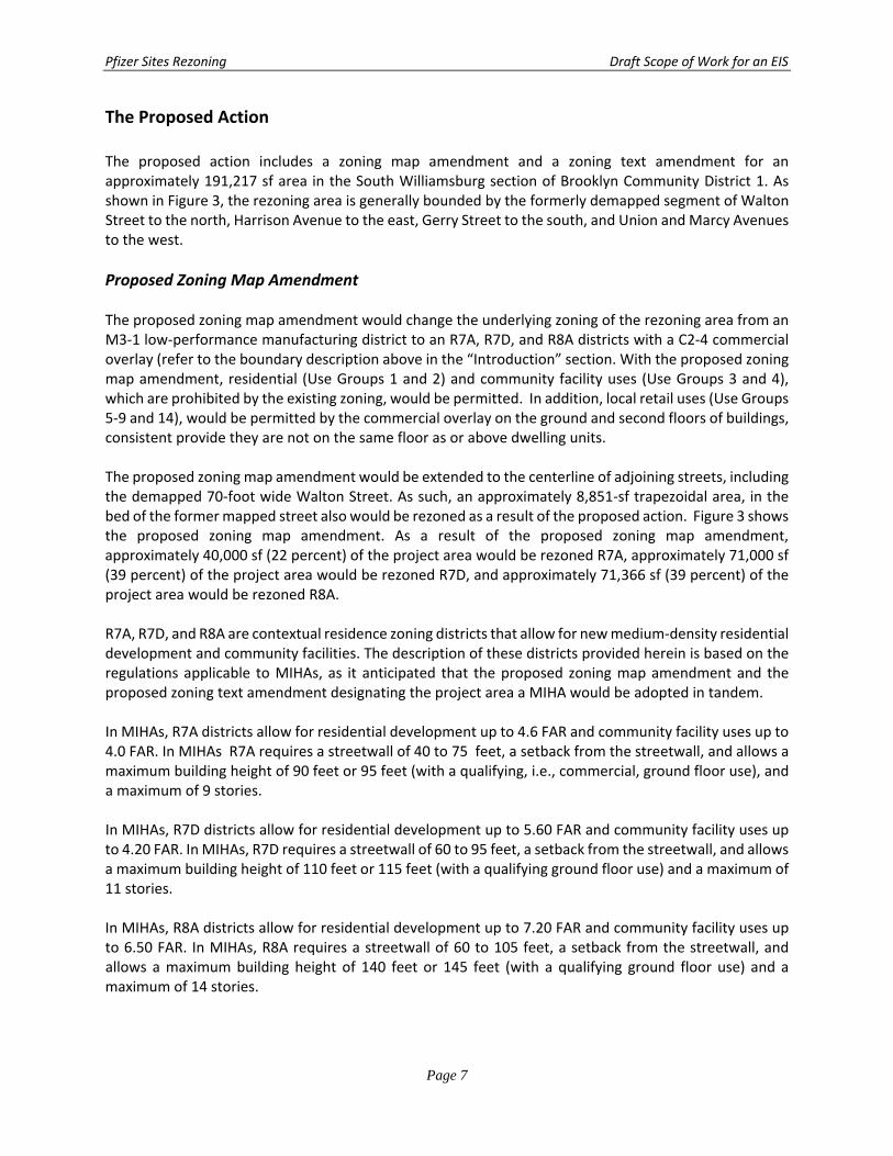
The proposed action includes a zoning map amendment and a zoning text amendment for an approximately 191,217 sf area in the South Williamsburg section of Brooklyn Community District 1. As shown in Figure 3, the rezoning area is generally bounded by the formerly demapped segment of Walton Street to the north, Harrison Avenue to the east, Gerry Street to the south, and Union and Marcy Avenues to the west.
Proposed Zoning Map Amendment The proposed zoning map amendment would change the underlying zoning of the rezoning area from an M3‐1 low‐performance manufacturing district to an R7A, R7D, and R8A districts with a C2‐4 commercial overlay (refer to the boundary description above in the “Introduction” section. With the proposed zoning map amendment, residential (Use Groups 1 and 2) and community facility uses (Use Groups 3 and 4), which are prohibited by the existing zoning, would be permitted. In addition, local retail uses (Use Groups 5‐9 and 14), would be permitted by the commercial overlay on the ground and second floors of buildings, consistent provide they are not on the same floor as or above dwelling units. The proposed zoning map amendment would be extended to the centerline of adjoining streets, including the demapped 70‐foot wide Walton Street. As such, an approximately 8,851‐sf trapezoidal area, in the bed of the former mapped street also would be rezoned as a result of the proposed action. Figure 3 shows the proposed zoning map amendment. As a result of the proposed zoning map amendment, approximately 40,000 sf (22 percent) of the project area would be rezoned R7A, approximately 71,000 sf (39 percent) of the project area would be rezoned R7D, and approximately 71,366 sf (39 percent) of the project area would be rezoned R8A. R7A, R7D, and R8A are contextual residence zoning districts that allow for new medium‐density residential development and community facilities. The description of these districts provided herein is based on the regulations applicable to MIHAs, as it anticipated that the proposed zoning map amendment and the proposed zoning text amendment designating the project area a MIHA would be adopted in tandem. In MIHAs, R7A districts allow for residential development up to 4.6 FAR and community facility uses up to 4.0 FAR. In MIHAs R7A requires a streetwall of 40 to 75 feet, a setback from the streetwall, and allows a maximum building height of 90 feet or 95 feet (with a qualifying, i.e., commercial, ground floor use), and a maximum of 9 stories. In MIHAs, R7D districts allow for residential development up to 5.60 FAR and community facility uses up to 4.20 FAR. In MIHAs, R7D requires a streetwall of 60 to 95 feet, a setback from the streetwall, and allows a maximum building height of 110 feet or 115 feet (with a qualifying ground floor use) and a maximum of 11 stories. In MIHAs, R8A districts allow for residential development up to 7.20 FAR and community facility uses up to 6.50 FAR. In MIHAs, R8A requires a streetwall of 60 to 105 feet, a setback from the streetwall, and allows a maximum building height of 140 feet or 145 feet (with a qualifying ground floor use) and a maximum of 14 stories.
Current Zoning Map
100’
GERRY
NOI
NU
NOI
NU
Proposed Zoning Map - Area being rezoned is outlined with dotted lines.Changing a M3-1 to a R7A/C2-4
M3-1 to a R7D/C2-4 M3-1 to a R8A/C2-4
100’
100’
220’
335’
Pfizer Sites Rezoning Figure 3Proposed Zoning Map Amendment
R 7DR 8A
R 7A
Pfizer Sites Rezoning Draft Scope of Work for an EIS
Page 8
New residences in R7A and R7D are required to provide off‐street parking spaces at a rate of 50 percent of the market rate dwelling units, with no required parking for affordable housing applicable to “transit zone” sites such as this site. New residences in R8A are required to provide one off‐street parking space at a rate of 40 percent of the market rate dwelling units, with not required parking for affordable housing applicable to “transit zone” sites. C2‐4 commercial overlays allow for local retail uses and commercial development up to 2.0 FAR. In these areas, the C2‐4 commercial overlays would support the development of mixed residential/commercial uses. Parking requirements in C2‐4 districts vary by use, but are required at 1 parking space for every 1,000 zsf of general retail.
Proposed Zoning Text Amendment The proposed zoning text amendment would amend Appendix F of the Zoning Resolution (ZR) to apply the Mandatory Inclusionary Housing (MIH) program to the rezoning area (see Figure 4). Under MIH, a share of new housing is required to be permanently affordable when land use actions create significant new housing potential, either as part of a City neighborhood plan or private land use application. MIH consists of two alternatives: 1) 25 percent of residential floor area be must be affordable housing units affordable to households with income at a weighted average of 60 percent of area median income (AMI), with 10 percent affordable to households within an income band of 40 percent of AMI; or 2) 30 percent of residential floor area must be affordable housing units affordable to households with income at a weighted average of 80 percent of AMI. In combination with these options, two other options may be utilized. A “Deep Affordability Option” also may be utilized providing 20 percent of residential floor area must be affordable housing units affordable to households with income at a weighted average of 40 percent of AMI. Also, a “Workforce Option” also may be utilized providing 30 percent of residential floor area must be affordable housing units affordable to households with income at a weighted average of 115 percent, with 5 percent of residential floor area must be affordable housing units affordable to households with income at an income band of 70 percent of AMI and another 5 percent of residential floor area must be affordable housing units affordable to households with income at an income band of 90 percent of AMI. Other restrictions apply to the Deep Affordability and Workforce Options. The CPC and ultimately the City Council determine requirements applicable to each MIHA.
D. ANALYSIS FRAMEWORK FOR ENVIRONMENTAL REVIEW The proposed action would change the regulatory controls governing land use and development in the rezoning area. The 2014 CEQR Technical Manual will serve as the general guide on the methodologies and impact criteria for evaluating the proposed action’s potential effects on the various environmental areas of analysis. The EIS assesses the reasonable worst‐case impacts that may occur as a result of the proposed action. In disclosing impacts, the EIS considers the proposed action’s potential adverse impacts on the environmental setting.
REASONABLE WORST‐CASE DEVELOPMENT SCENARIO (RWCDS) In order to assess the possible effects of the proposed action, a reasonable worst‐case development scenario (RWCDS) for the proposed rezoning area was established for both Future No‐Action and Future

Existing Proposed
Pfizer Sites Rezoning Figure 4Proposed Zoning Text Amendment
MIH Program Option 1 [Section 23-154 (d) (3)]
Inclusionary Housing Designated Area (IHDA)
Mandatory Inclusionary Housing Area (MIHA)
1
1

Pfizer Sites Rezoning Draft Scope of Work for an EIS
Page 9
With‐Action conditions. The incremental difference between the Future No‐Action and Future With‐Action conditions will serve as the basis of the impact category analyses in the EIS. To determine the With‐Action and No‐Action conditions, standard methodologies have been used following the CEQR Technical Manual guidelines employing reasonable assumptions. These methodologies have been used to identify the amount and location of future development, as discussed below.
Development Site Criteria In projecting the amount and location of new development, several factors have been considered in identifying likely development sites. These include known development proposals and past development trends. The first step in establishing the development scenario was to identify those sites where new development could reasonably occur. The Applicant’s development proposal for the 182,368 sf project area, including both the Northern and Southern Blocks, is considered a known proposal likely to occur. In addition to the Applicant’s property, the proposed rezoning area includes an approximately 8,851‐sf trapezoidal area, in the bed of the former mapped street. However, this area is owned by the City and continues to function as a street, and is not within any designated tax lots or zoning lots. No development is expected to occur in the bed of Walton Street as a result of the proposed action as it is expected to continue to operate as a street. The City previously intended for this area to form part of an industrial development site (per the 1989 Broadway Triangle Urban Renewal Plan) and later to form part of a commercial development site (per a 2000 proposal that was not advanced). These development proposals, which would have involved the disposition of the demapped Walton Street to a previous property owner, are no longer active. Disposition of the demapped portion of Walton Street or any development rights associated with the property cannot occur without a ULURP action for disposition of property owned by the City of New York, and possibly related actions subject to ULURP and CEQR such as designation as an Urban Development Action Area Plan (UDAAP). In any event, the Applicant has not proposed to purchase this property or execute a zoning lot development agreement or similar arrangement that would allow it to use floor area generated by the street on the adjoining Northern Block. Unlike the previous industrial and commercial development proposals which intended to use the bed of the demapped street to accommodate development requiring a “superblock” site plan, the applicant is proposing a contextual mixed residential‐commercial development that can be accommodated by the 200‐foot wide Northern and Southern Blocks. As such, the proposed action is not expected to generate any development using the area of demapped Walton Street or development rights generated by it and it is not considered in the RWCDS. Therefore, the only the applicant’s property, consisting of the Northern and Southern Blocks (project area), have been identified as development sites in the rezoning area.
The Future without the Proposed Action (No‐Action Condition) The future without the proposed action—also known as the “No‐Action condition”—assumes that none of the public approvals being sought are approved. The existing M3‐1 zoning would remain in place. In this case, absent the proposed action, it is anticipated that the project area would continue to remain vacant and would not support any active uses. Further, under the terms of the 2001 deed restriction
Pfizer Sites Rezoning Draft Scope of Work for an EIS
Page 10
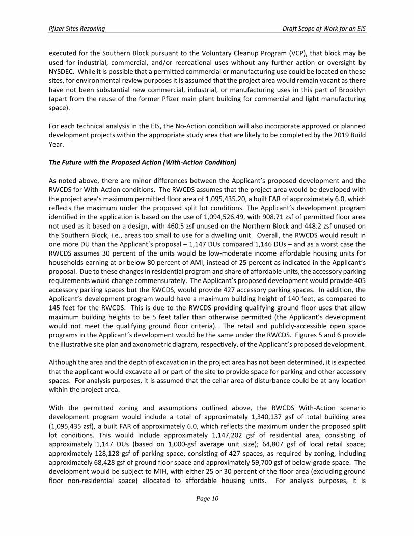
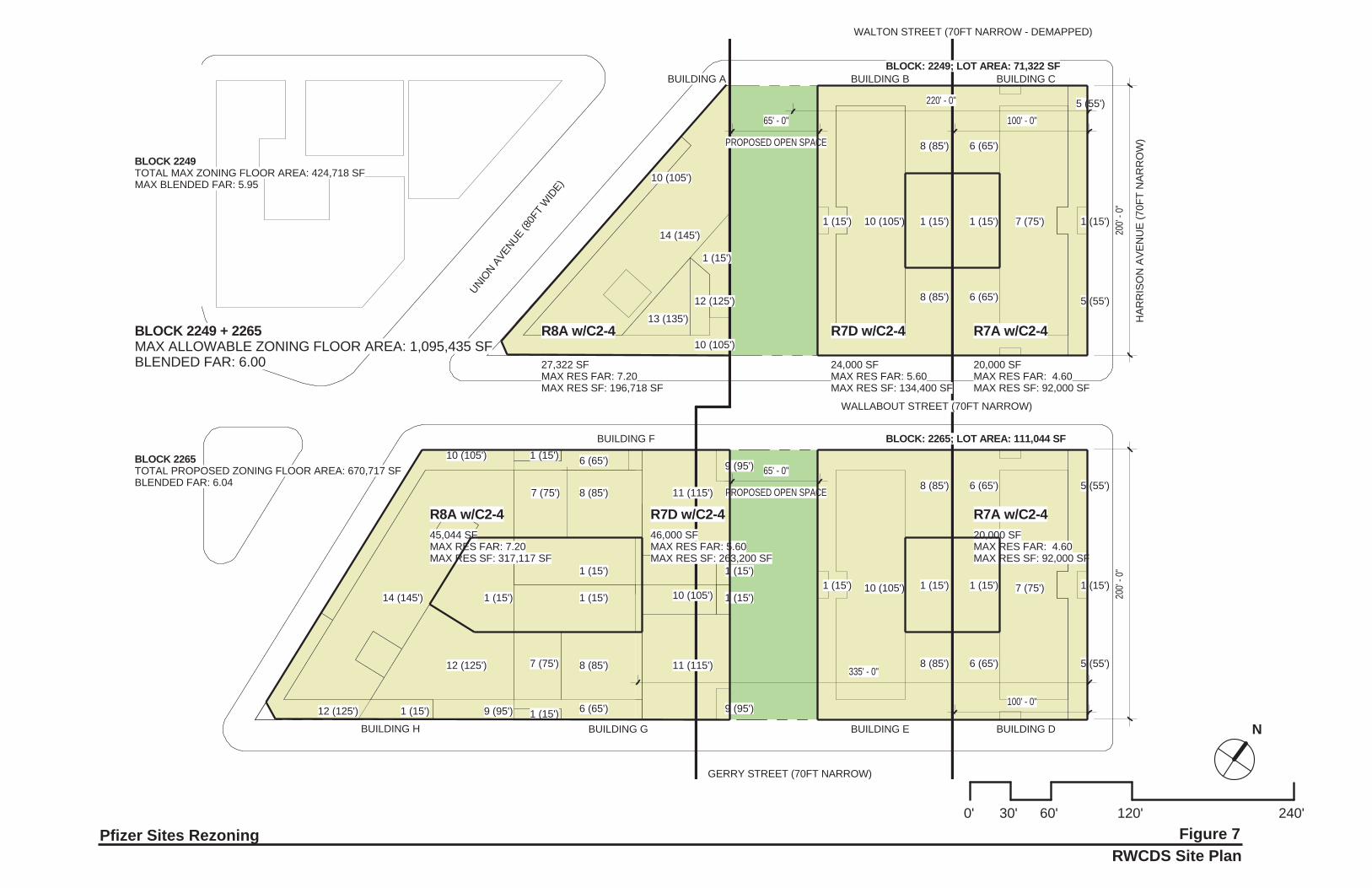
executed for the Southern Block pursuant to the Voluntary Cleanup Program (VCP), that block may be used for industrial, commercial, and/or recreational uses without any further action or oversight by NYSDEC. While it is possible that a permitted commercial or manufacturing use could be located on these sites, for environmental review purposes it is assumed that the project area would remain vacant as there have not been substantial new commercial, industrial, or manufacturing uses in this part of Brooklyn (apart from the reuse of the former Pfizer main plant building for commercial and light manufacturing space). For each technical analysis in the EIS, the No‐Action condition will also incorporate approved or planned development projects within the appropriate study area that are likely to be completed by the 2019 Build Year. The Future with the Proposed Action (With‐Action Condition) As noted above, there are minor differences between the Applicant’s proposed development and the RWCDS for With‐Action conditions. The RWCDS assumes that the project area would be developed with the project area’s maximum permitted floor area of 1,095,435.20, a built FAR of approximately 6.0, which reflects the maximum under the proposed split lot conditions. The Applicant’s development program identified in the application is based on the use of 1,094,526.49, with 908.71 zsf of permitted floor area not used as it based on a design, with 460.5 zsf unused on the Northern Block and 448.2 zsf unused on the Southern Block, i.e., areas too small to use for a dwelling unit. Overall, the RWCDS would result in one more DU than the Applicant’s proposal – 1,147 DUs compared 1,146 DUs – and as a worst case the RWCDS assumes 30 percent of the units would be low‐moderate income affordable housing units for households earning at or below 80 percent of AMI, instead of 25 percent as indicated in the Applicant’s proposal. Due to these changes in residential program and share of affordable units, the accessory parking requirements would change commensurately. The Applicant’s proposed development would provide 405 accessory parking spaces but the RWCDS, would provide 427 accessory parking spaces. In addition, the Applicant’s development program would have a maximum building height of 140 feet, as compared to 145 feet for the RWCDS. This is due to the RWCDS providing qualifying ground floor uses that allow maximum building heights to be 5 feet taller than otherwise permitted (the Applicant’s development would not meet the qualifying ground floor criteria). The retail and publicly‐accessible open space programs in the Applicant’s development would be the same under the RWCDS. Figures 5 and 6 provide the illustrative site plan and axonometric diagram, respectively, of the Applicant’s proposed development. Although the area and the depth of excavation in the project area has not been determined, it is expected that the applicant would excavate all or part of the site to provide space for parking and other accessory spaces. For analysis purposes, it is assumed that the cellar area of disturbance could be at any location within the project area. With the permitted zoning and assumptions outlined above, the RWCDS With‐Action scenario development program would include a total of approximately 1,340,137 gsf of total building area (1,095,435 zsf), a built FAR of approximately 6.0, which reflects the maximum under the proposed split lot conditions. This would include approximately 1,147,202 gsf of residential area, consisting of approximately 1,147 DUs (based on 1,000‐gsf average unit size); 64,807 gsf of local retail space; approximately 128,128 gsf of parking space, consisting of 427 spaces, as required by zoning, including approximately 68,428 gsf of ground floor space and approximately 59,700 gsf of below‐grade space. The development would be subject to MIH, with either 25 or 30 percent of the floor area (excluding ground floor non‐residential space) allocated to affordable housing units. For analysis purposes, it is
N
0' 30' 60' 120' 240'
BLOCK: 2249; LOT AREA: 71,322 SF
BLOCK: 2265; LOT AREA: 111,044 SF
UNION A
VENUE(8
0FT
WID
E)
WALLABOUT STREET (70FT NARROW)
HAR
RIS
ON
AVE
NU
E (7
0FT
NAR
RO
W)
GERRY STREET (70FT NARROW)
BLOCK 2249TOTAL MAX ZONING FLOOR AREA: 424,718 SFMAX BLENDED FAR: 5.95
BLOCK 2265TOTAL PROPOSED ZONING FLOOR AREA: 670,717 SFBLENDED FAR: 6.04
BLOCK 2249 + 2265MAX ALLOWABLE ZONING FLOOR AREA: 1,095,435 SFBLENDED FAR: 6.00
WALTON STREET (70FT NARROW - DEMAPPED)
R7D w/C2-4
R7D w/C2-4
R8A w/C2-4
R8A w/C2-4
200'
- 0"
100' - 0"
R7A w/C2-4
R7A w/C2-4
20,000 SFMAX RES FAR: 4.60MAX RES SF: 92,000 SF
220' - 0"
200'
- 0"
24,000 SFMAX RES FAR: 5.60MAX RES SF: 134,400 SF
27,322 SFMAX RES FAR: 7.20MAX RES SF: 196,718 SF
20,000 SFMAX RES FAR: 4.60MAX RES SF: 92,000 SF
46,000 SFMAX RES FAR: 5.60MAX RES SF: 263,200 SF
100' - 0"
45,044 SFMAX RES FAR: 7.20MAX RES SF: 317,117 SF
335' - 0"
PROPOSED OPEN SPACE
65' - 0"
PROPOSED OPEN SPACE
65' - 0"
14 (140')
13 (130')
12 (120')
10 (100')
10 (100')
1 (10')
1 (10') 1 (10') 1 (10') 1 (10')10 (100') 7 (75')
10 (100') 7 (70')1 (10') 1 (10') 1 (10') 1 (10')
8 (80') 6 (60')
8 (80') 6 (60')
8 (80') 6 (60')
8 (80') 6 (60')
1 (10')1 (10')
1 (10')
1 (10')
1 (10')1 (10')
1 (10')
11 (110')8 (80')7 (70')
6 (60')
11 (110')8 (80')7 (70')
6 (60')
9 (90')
12 (120')
1 (10')12 (120')
10 (100')
14 (140')
BUILDING A BUILDING B BUILDING C
BUILDING G BUILDING E BUILDING D
BUILDING F
BUILDING H
9 (90')
5 (50')
5 (50')
5 (50')
5 (50')
10 (100')
9 (90')
Pfizer Sites Rezoning Applicant’s Proposed Development Site Plan
Figure 5
N
0' 40' 80' 160' 320'
11 (110’)
11 (110’)
10 (100’)
10 (100’)
8 (80’)
7 (70’)
6 (60’)
8 (80’)
7 (70’)
8 (80’)
6 (60’)
7 (70’)
5 (50’)
8 (80’)
6 (60’)
8 (80’)
6 (60’)
7 (70’)
5 (50’)
8 (80’)
6 (60’)
14 (140’)
13 (130’)
12 (120’)
10 (100’)
14 (140’)
12 (120’)
12 (120’)
9 (90’)
BUILDING A
BUILDING B
BUILDING C
BUILDING E
BUILDING D
BUILDING F
BUILDING G
BUILDING H
10 (100’)
9 (90’)
9 (90’)
10 (100’)
USES:
ResidentialCommercialParkingOpen Space
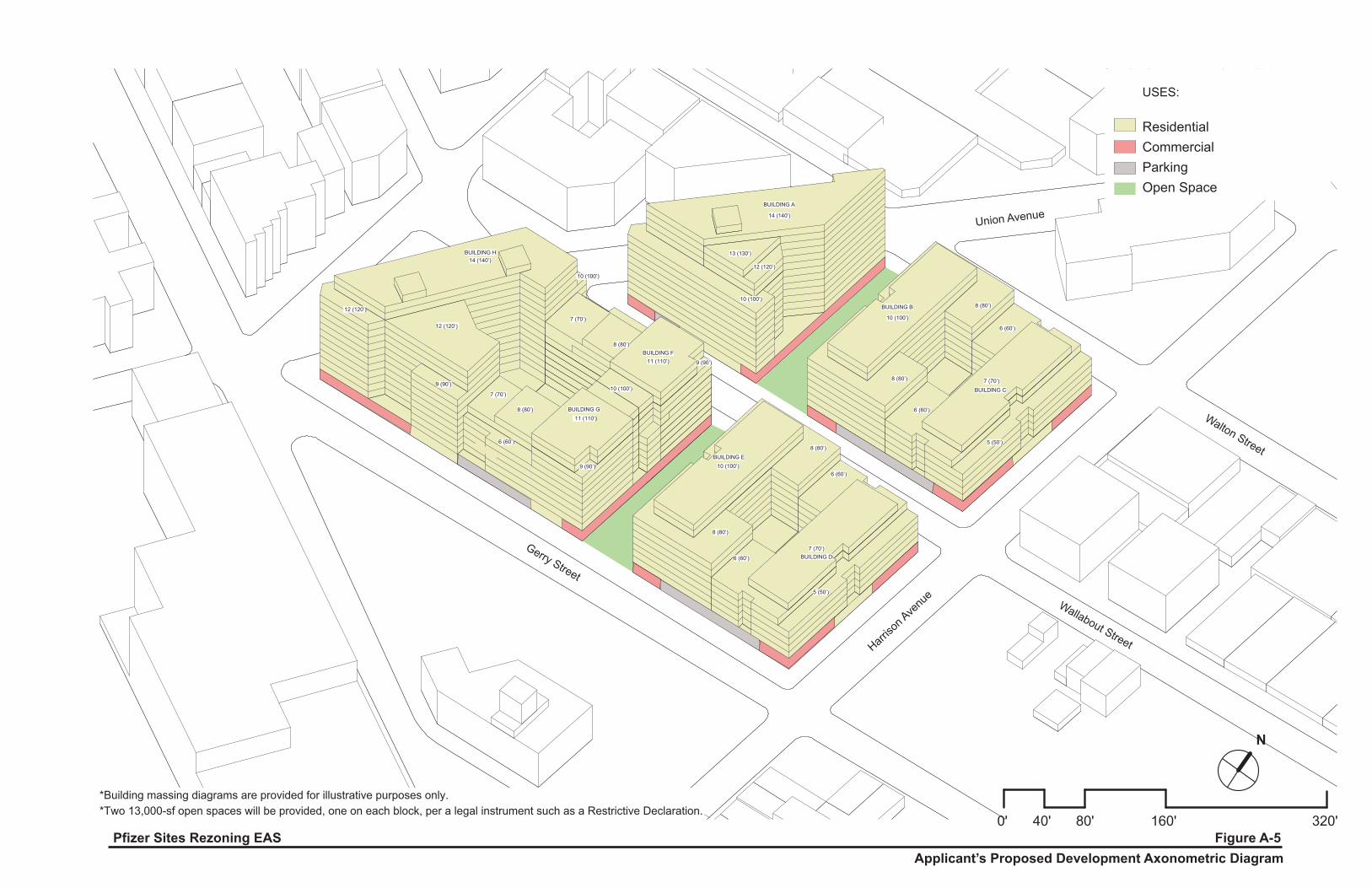
*Two 13,000-sf open spaces will be provided, one on each block, per a legal instrument such as a Restrictive Declaration.*Building massing diagrams are provided for illustrative purposes only.
Applicant’s Proposed Development Axonometric DiagramFigure A-5Pfizer Sites Rezoning EAS
Gerry Street
Harriso
n Ave
nue
Wallabout Street
Walton Street
Union Avenue
Pfizer Sites Rezoning Draft Scope of Work for an EIS
Page 11
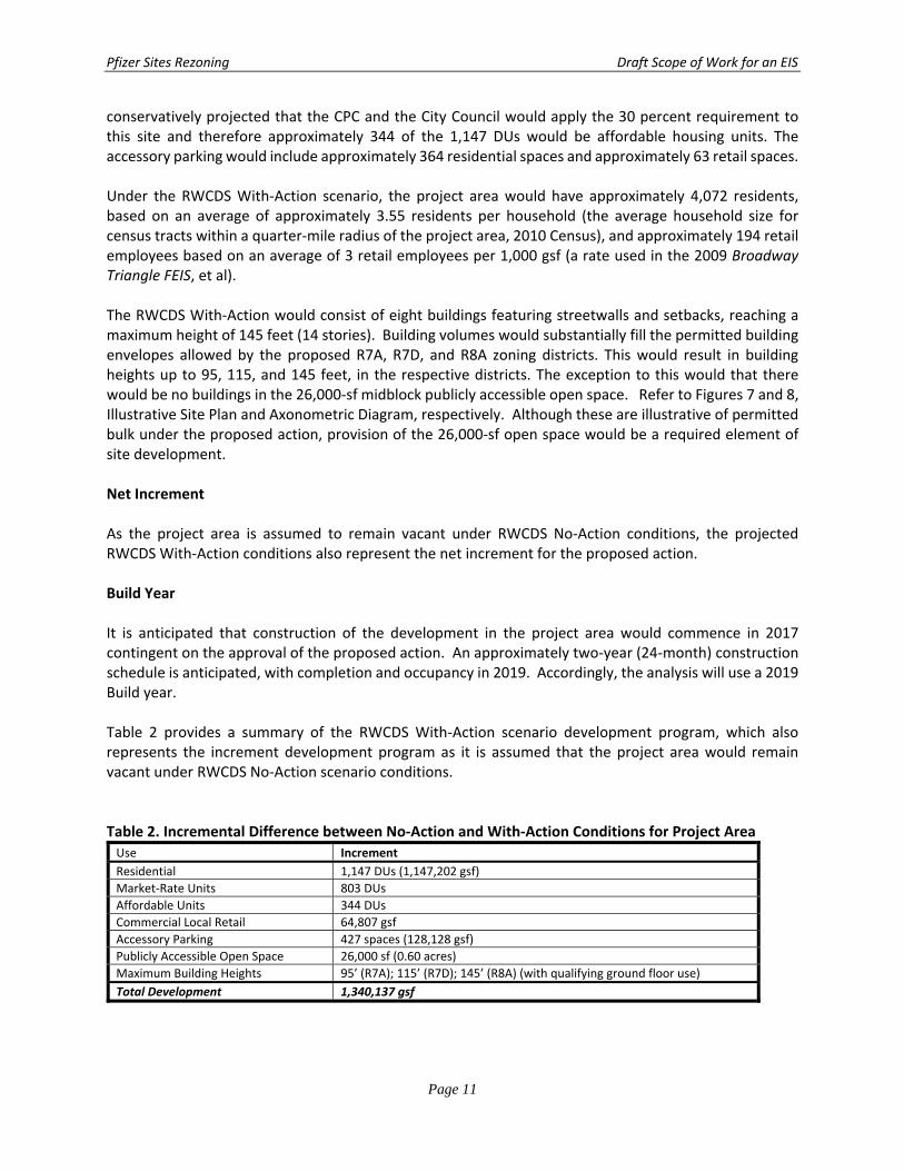
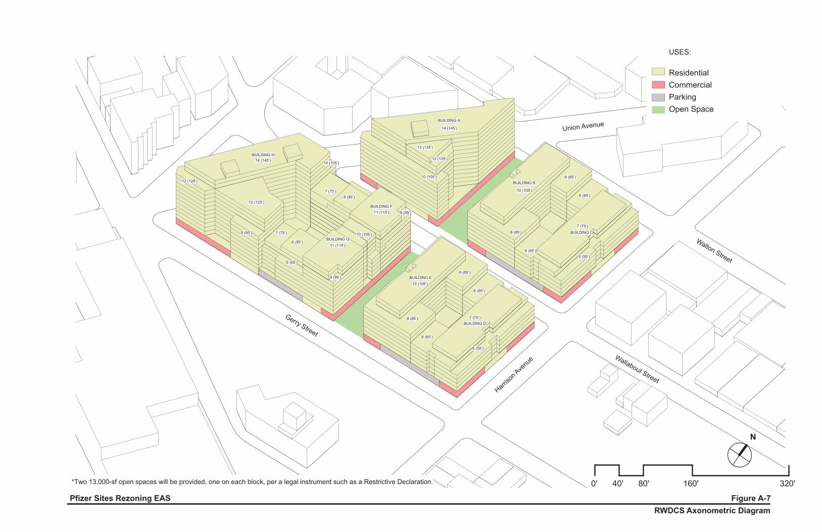
conservatively projected that the CPC and the City Council would apply the 30 percent requirement to this site and therefore approximately 344 of the 1,147 DUs would be affordable housing units. The accessory parking would include approximately 364 residential spaces and approximately 63 retail spaces. Under the RWCDS With‐Action scenario, the project area would have approximately 4,072 residents, based on an average of approximately 3.55 residents per household (the average household size for census tracts within a quarter‐mile radius of the project area, 2010 Census), and approximately 194 retail employees based on an average of 3 retail employees per 1,000 gsf (a rate used in the 2009 Broadway Triangle FEIS, et al). The RWCDS With‐Action would consist of eight buildings featuring streetwalls and setbacks, reaching a maximum height of 145 feet (14 stories). Building volumes would substantially fill the permitted building envelopes allowed by the proposed R7A, R7D, and R8A zoning districts. This would result in building heights up to 95, 115, and 145 feet, in the respective districts. The exception to this would that there would be no buildings in the 26,000‐sf midblock publicly accessible open space. Refer to Figures 7 and 8, Illustrative Site Plan and Axonometric Diagram, respectively. Although these are illustrative of permitted bulk under the proposed action, provision of the 26,000‐sf open space would be a required element of site development. Net Increment As the project area is assumed to remain vacant under RWCDS No‐Action conditions, the projected RWCDS With‐Action conditions also represent the net increment for the proposed action. Build Year It is anticipated that construction of the development in the project area would commence in 2017 contingent on the approval of the proposed action. An approximately two‐year (24‐month) construction schedule is anticipated, with completion and occupancy in 2019. Accordingly, the analysis will use a 2019 Build year. Table 2 provides a summary of the RWCDS With‐Action scenario development program, which also represents the increment development program as it is assumed that the project area would remain vacant under RWCDS No‐Action scenario conditions. Table 2. Incremental Difference between No‐Action and With‐Action Conditions for Project Area
Use Increment
Residential 1,147 DUs (1,147,202 gsf)
Market‐Rate Units 803 DUs
Affordable Units 344 DUs
Commercial Local Retail 64,807 gsf
Accessory Parking 427 spaces (128,128 gsf)
Publicly Accessible Open Space 26,000 sf (0.60 acres)
Maximum Building Heights 95’ (R7A); 115’ (R7D); 145’ (R8A) (with qualifying ground floor use)
Total Development 1,340,137 gsf
N
0' 30' 60' 120' 240'
BLOCK: 2249; LOT AREA: 71,322 SF
BLOCK: 2265; LOT AREA: 111,044 SF
UNION A
VENUE(8
0FT
WID
E)
WALLABOUT STREET (70FT NARROW)
HAR
RIS
ON
AVE
NU
E (7
0FT
NAR
RO
W)
GERRY STREET (70FT NARROW)
BLOCK 2249TOTAL MAX ZONING FLOOR AREA: 424,718 SFMAX BLENDED FAR: 5.95
BLOCK 2265TOTAL PROPOSED ZONING FLOOR AREA: 670,717 SFBLENDED FAR: 6.04
BLOCK 2249 + 2265MAX ALLOWABLE ZONING FLOOR AREA: 1,095,435 SFBLENDED FAR: 6.00
WALTON STREET (70FT NARROW - DEMAPPED)
R7D w/C2-4
R7D w/C2-4
R8A w/C2-4
R8A w/C2-4
200'
- 0"
100' - 0"
R7A w/C2-4
R7A w/C2-4
20,000 SFMAX RES FAR: 4.60MAX RES SF: 92,000 SF
220' - 0"
200'
- 0"
24,000 SFMAX RES FAR: 5.60MAX RES SF: 134,400 SF
27,322 SFMAX RES FAR: 7.20MAX RES SF: 196,718 SF
20,000 SFMAX RES FAR: 4.60MAX RES SF: 92,000 SF
46,000 SFMAX RES FAR: 5.60MAX RES SF: 263,200 SF
100' - 0"
45,044 SFMAX RES FAR: 7.20MAX RES SF: 317,117 SF
335' - 0"
PROPOSED OPEN SPACE
65' - 0"
PROPOSED OPEN SPACE
65' - 0"
14 (145')
13 (135')
12 (125')
10 (105')
10 (105')
1 (15')
1 (15') 1 (15') 1 (15') 1 (15')10 (105') 7 (75')
10 (105') 7 (75')1 (15') 1 (15') 1 (15') 1 (15')
8 (85') 6 (65')
8 (85') 6 (65')
8 (85') 6 (65')
8 (85') 6 (65')
1 (15')1 (15')
1 (15')
1 (15')
1 (15')1 (15')
1 (15')
11 (115')8 (85')7 (75')
6 (65')
11 (115')8 (85')7 (75')
6 (65')
9 (95')
12 (125')
1 (15')12 (125')
10 (105')
14 (145')
BUILDING A BUILDING B BUILDING C
BUILDING G BUILDING E BUILDING D
BUILDING F
BUILDING H
9 (95')
5 (55')
5 (55')
5 (55')
5 (55')
10 (105')
9 (95')
Pfizer Sites Rezoning RWCDS Site Plan
Figure 7
11 (115’)
11 (115’)
10 (105’)
10 (105’)
8 (85’)
7 (75’)
6 (65’)
8 (85’)7 (75’)
8 (85’)
6 (65’)
7 (75’)
5 (55’)
8 (85’)
6 (65’)
8 (85’)
6 (65’)
7 (75’)
5 (55’)
8 (85’)
6 (65’)
14 (145’)
13 (135’)
12 (125’)
10 (105’)
14 (145’)
12 (125’)
12 (125’)
9 (95’)
BUILDING A
BUILDING B
BUILDING C
BUILDING E
BUILDING D
BUILDING F
BUILDING G
BUILDING H
10 (105’)
9 (95’)
9 (95’)
10 (105’)
0' 40' 80' 160' 320'
N
USES:
ResidentialCommercialParkingOpen Space
*Two 13,000-sf open spaces will be provided, one on each block, per a legal instrument such as a Restrictive Declaration.
RWDCS Axonometric DiagramFigure A-7Pfizer Sites Rezoning EAS
Gerry Street
Harriso
n Ave
nue Wallabout Street
Walton Street
Union Avenue
Pfizer Sites Rezoning Draft Scope of Work for an EIS
Page 12
E. PROPOSED SCOPE OF WORK FOR THE ENVIRONMENTAL IMPACT STATEMENT (EIS) Because the proposed action and associated RWCDS would affect various areas of environmental concern and were found to have the potential for significant adverse impacts, pursuant to the EAS and Positive Declaration, an Environmental Impact Statement (EIS) will be prepared for the proposed action that will analyze all technical areas of concern. The EIS will be prepared in conformance with all applicable laws and regulations, including SEQRA (Article 8 of the New York State Environmental Conservation Law) and its implementing regulations found at 6 NYCRR Part 617, New York City Executive Order No. 91 of 1977, as amended, and the Rules of Procedure for CEQR, found at Title 62, Chapter 5 of the Rules of the City of New York. The EIS will follow the guidance of the 2014 CEQR Technical Manual, and will contain:
A description of the proposed action and its environmental setting;
A statement of the environmental impacts of the proposed action, including its short‐and long‐term effects and typical associated environmental effects;
An identification of any adverse environmental effects that cannot be avoided if the proposed action is implemented;
A discussion of reasonable alternatives to the proposed action;
An identification of irreversible and irretrievable commitments of resources that would be involved in the proposed action should it be implemented; and
A description of mitigation measures proposed to eliminate or minimize any significant adverse environmental impacts.
Based on the preliminary screening assessments outlined in the CEQR Technical Manual and detailed in the EAS document, the following environmental areas would not require detailed analysis in the EIS: natural resources, solid waste and sanitation services, and energy. The specific areas to be included in the EIS, as well as their respective tasks, are described below. Each chapter of the EIS that requires a detailed analysis will include an analysis of the future With‐Action condition compared to the future No‐Action condition, as set forth in the CEQR Technical Manual. The technical analyses of the EIS will examine the potential impacts related to the completion of the RWCDS by the 2019 Build Year.
TASK 1. PROJECT DESCRIPTION
The first chapter of the EIS introduces the reader to the proposed action and sets the context in which to assess impacts. The chapter contains a description of the proposed action: its location; the background and/or history of the project; a statement of the purpose and need; key planning considerations that have shaped the current proposal; a detailed description of the proposed action; and discussion of the approvals required, procedures to be followed, and the role of the EIS in the process. This chapter is the key to understanding the proposed action and its impact, and gives the public and decision‐makers a base from which to evaluate the proposed action.
The project description chapter will present the planning background and rationale for the actions being proposed and summarize the reasonable worst‐case development scenario (RWCDS) for analysis in the
Pfizer Sites Rezoning Draft Scope of Work for an EIS
Page 13
EIS. The section on approval procedures will explain the Uniform Land Use Review Procedure (ULURP) process, its timing, and hearings before the Community Board, the Borough President's Office, the New York City Planning Commission (CPC), and the New York City Council. The role of the EIS as a full‐disclosure document to aid in decision‐making will be identified and its relationship to ULURP and the public hearings described.
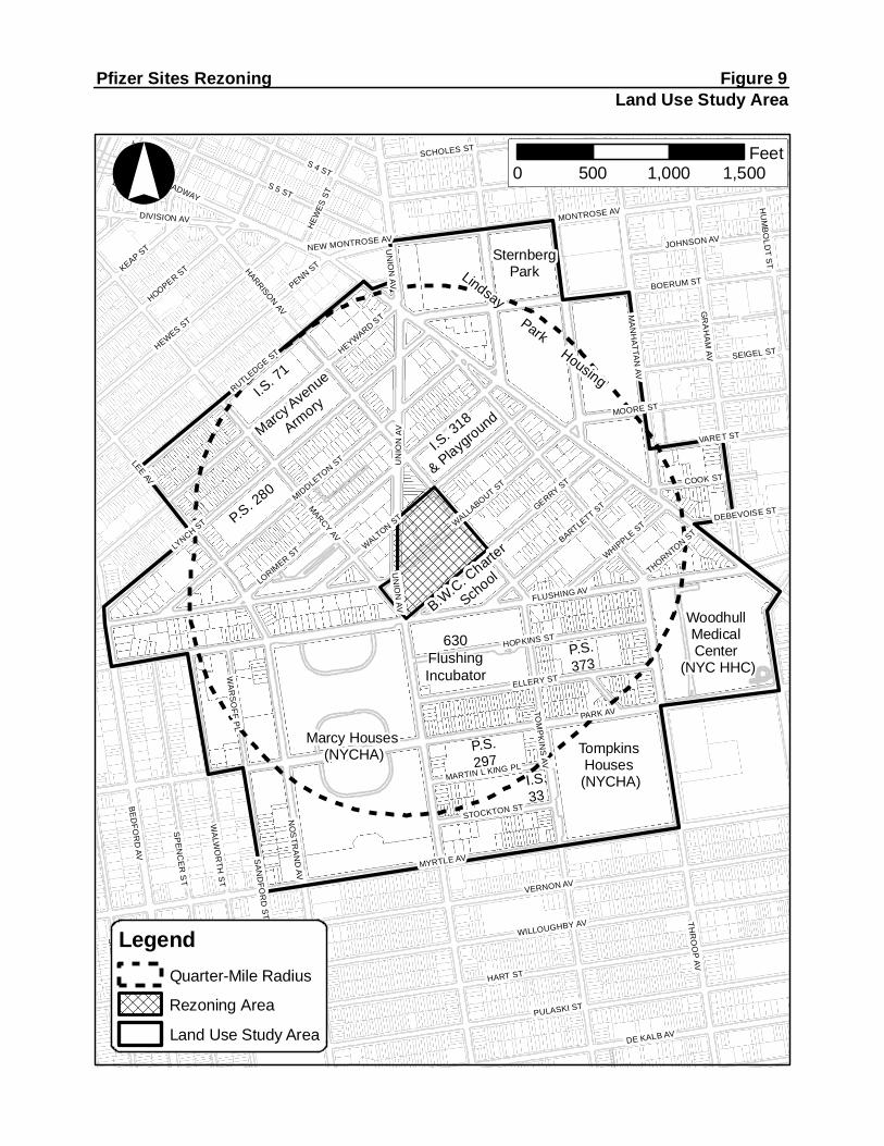
TASK 2. LAND USE, ZONING, AND PUBLIC POLICY The proposed action would result in changes to land use and changes in permitted land use density in the project area. This chapter of the EIS will consider the project’s compatibility with surrounding land use, zoning and development trends in the area, as well as public policy related to land use and economic development. The land use, zoning and public policy analysis will be consistent with the methodologies presented in the CEQR Technical Manual. In completing the following subtasks, the land use study area will consist of the project area, where the land use impacts will be straightforward and direct (reflecting the proposed action), and the neighboring areas within an approximate ¼‐mile radius from the boundaries of the project are, a distance that, based on CEQR Technical Manual guidelines, defines the area in which the proposed action and associated RWCDS could reasonably be expected to create potential direct and indirect impacts (see Figure 9). The land use assessment will include a description of existing conditions and evaluations of the future with and without the proposed action in 2019. Subtasks will include the following:
Provide a brief development history of the project area and surrounding study area.
Provide a description of land use in the project area.
Provide a description and map of existing land use patterns and trends in the study area, including a description of recent development activity, and identify major factors influencing land use trends.
Provide a zoning map and describe the existing zoning, including any recent zoning actions in the study area.
Describe any public policies that apply to the project area and the study area, including specific development projects and plans for public improvements. Public policies that apply to the study area include Housing New York: A Five‐Borough Ten‐Year Plan, and One NYC (formerly PlaNYC). In addition, the project area is located within the coastal zone boundary (CZB). Actions subject to CEQR, such as the ones described in this proposal that are located within the designated boundaries of the coastal zone must be assessed for their consistency with the City’s Waterfront Revitalization Program (WRP). The assessment provided in the EIS will evaluate, for those relevant policies identified on the project’s WRP Consistency Assessment Form, the consistency of the proposed action and associated RWCDS with the WRP policies.
Prepare a list of future development projects in the study area that would be expected to be constructed by the 2019 analysis year and may influence future land use trends in the future without the proposed action. Also, identify pending zoning actions (including those associated with the identified No‐Build projects) or other public policy actions that could affect land use patterns and trends in the study area as they relate to the proposed action. Based on these planned projects and initiatives, assess future conditions in the land use and zoning study area in the future without the proposed action (No‐Action condition).
TompkinsHouses(NYCHA)
Marcy Houses(NYCHA)
P.S. 280
I.S. 71
MarcyAve
nue
Armory
I.S. 318
& Playground
SternbergPark
WoodhullMedicalCenter
(NYC HHC)
B.W.C. Charte
r
School
ParkHousing
Lindsay
MARCYAV
PARK AV
THR
OO
PAV
MYRTLE AV
FLUSHING AV
HART ST
LYNCH ST
LORIMER
ST
VERNON AV
PULASKI ST
BE
DFO
RD
AVLEE
AV
S 5 ST
HARRISONAV G
RA
HA
MAV
TOM
PK
INS
AV
WALLABOUT ST
PENN ST
SP
EN
CE
RS
T
BOERUM ST
NO
STR
AN
DAV
WILLOUGHBY AV
HEYWARD ST
MESEROLE ST
DE KALB AV
WA
LWO
RTH
ST
MONTROSE AV
MIDDLETON
ST UN
ION
AVRUTLEDGE ST
WALTON
ST
MA
NH
ATTAN
AV
GERRY ST
HOOPER ST
HEWES ST
ELLERY ST
S 4 ST
KEAP ST
MOORE ST
HOPKINS ST
SK
ILLMA
NS
T
HU
MB
OLD
TS
T
SA
ND
FOR
DS
T
SCHOLES ST
BARTLETT ST
SEIGEL ST
VARET ST
BROADWAY
JOHNSON AV
COOK ST
DIVISION AV
WHIPPLE ST
WA
RS
OFF
PL
RO
DN
EY
ST
STOCKTON ST
MARTIN L KING PL
DEBEVOISE ST
THORNTONST
NEW MONTROSE AV
HEW
ESST
UN
ION
AV
WILLOUGHBY AV
UN
ION
AV
°
Pfizer Sites Rezoning Figure 9Land Use Study Area
LegendQuarter-Mile Radius
Rezoning Area
Land Use Study Area
0 500 1,000 1,500Feet
630FlushingIncubator
630FlushingIncubator
P.S.373
P.S. 297
I.S.33
Pfizer Sites Rezoning Draft Scope of Work for an EIS
Page 14
Describe the proposed zoning map and zoning text amendments, and the potential land use changes resulting from the proposed action, i.e., the RWCDS for the project area.
Discuss the proposed action’s potential indirect effects related to issues of compatibility with surrounding land use, the consistency with zoning and other public policies, and the effect of the proposed action on ongoing development trends and conditions in the study area.
If the results of the impact analysis identify a potential for a significant adverse impact, discuss potential mitigation measures.
TASK 3. SOCIOECONOMIC CONDITIONS
Socioeconomic impacts can occur when a proposed project directly or indirectly changes economic activities in an area. The purpose of the socioeconomic assessment is to disclose changes that would be created by a proposed action(s) and identify whether they rise to a significant level. The socioeconomic chapter will examine the effects of the proposed action on socioeconomic conditions in the project area and in the surrounding neighborhood. The analysis will follow the guidelines of the CEQR Technical Manual in assessing the proposed action’s effects on socioeconomic conditions. The analysis will present information regarding the effects of the project to make a preliminary assessment either to rule out the possibility of significant impacts or to determine that more detailed analysis is required to make a determination as to impacts. According to CEQR Technical Manual guidelines, the five principal issues of concern with respect to socioeconomic conditions are whether a proposed action would result in significant impacts due to: (1) direct residential displacement; (2) direct business and institutional displacement; (3) indirect residential displacement; (4) indirect business/institutional displacement; and (5) adverse effects on a specific industry. As detailed below, the proposed action warrants an assessment of socioeconomic conditions with respect to indirect residential displacement. As the project area does not have any active uses, the proposed action would not have the potential to result in the direct displacement of any residents, businesses, or institutions, and therefore, an assessment of potential socioeconomic effects due to direct residential, business, and institutional displacement is not warranted for the proposed action. According to the 2014 CEQR Technical Manual, commercial development of less than 200,000 square feet (sf) would typically not have the potential to result in significant adverse indirect business or institutional displacement. For projects exceeding this threshold, an assessment of indirect business displacement is appropriate. The proposed action/RWCDS would not introduce commercial development exceeding this CEQR Technical Manual threshold: the RWCDS is projected to result in 64,807 gsf of local retail space and therefore would not warrant detailed analysis. In further support of this screening, according to 2014 PLUTO data, within a half‐mile area surrounding the project area there is approximately 1.48 million gross square feet of retail space and within a more immediate quarter‐mile area surrounding the project area there is approximately 252,500 gsf of retail. The 64,807 gsf of local ground floor retail in the project area generated under the RWCDS equates to slightly more than a four percent increase in retail space within a half‐mile and about a 25 percent increase in a quarter‐mile radius. The RWCDS projected retail is expected to support the existing and project‐generated populations, as well as the consumer demand that would be added to the study area in the future without the proposed action. Therefore, further assessment of indirect business displacement is not warranted and will not be provided in the EIS.

Pfizer Sites Rezoning Draft Scope of Work for an EIS
Page 15
The proposed action and associated RWCDS would not result in significant adverse impacts due to indirect business and institutional displacement. In most cases, the issue for indirect business and institutional displacement is whether an action would increase property values and thus rents throughout the area, making it difficult for some categories of businesses to remain. According to the CEQR Technical Manual, commercial development of less than 200,000 square feet (sf) would typically not result in significant socioeconomic impacts. The RWCDS would introduce approximately 64,807 gsf of local ground floor retail along two street frontages of the project area, which is expected to support the existing and project‐generated populations, as well as the consumer demand that would be added to the study area in the future without the proposed action. In addition, the CEQR Technical Manual indicates that an assessment is appropriate if a project is expected to affect conditions within a specific industry. This could affect socioeconomic conditions if a substantial number of workers or residents depend on the goods or services provided by the affected businesses, or if the project would result in the loss or substantial diminishment of a particularly important product or service within the city. As noted above, the project area is currently vacant, apart from temporary uses such as short‐term rental for storage of vehicles and construction equipment/supply, and does not support any existing buildings, and therefore the proposed action would not directly displace any businesses or employees. Moreover, the proposed action is site‐specific, and does not include any citywide regulatory change that would adversely affect the economic and operational conditions of certain types of businesses or processes. Therefore, the proposed action would not result in significant adverse effects on specific industries, and no further assessment is warranted. In conformance with the CEQR Technical Manual guidelines, the assessment of the remaining area of concern, indirect residential displacement, will begin with a preliminary assessment to determine whether a detailed analysis is necessary. A detailed analysis will be conducted if the preliminary assessment cannot definitively rule out the potential for significant adverse impacts. The detailed assessment would be framed in the context of existing conditions and evaluations of the future No‐Action and With‐Action conditions in 2019, including any population changes anticipated to take place by the analysis year for the proposed action.
Indirect Residential Displacement
The indirect residential displacement analysis will use the most recent available U.S. Census data, New York City Department of Finance’s Real Property Assessment Data (RPAD) database, as well as current real estate market data, to present demographic and residential market trends and conditions for the ¼‐ mile study area. Pursuant to CEQR Technical Manual guidelines, this study area would be increased to a ½‐mile radius if the preliminary analysis reveals that the increase in population resulting from the proposed action and associated RWCDS would exceed 5 percent in the ¼‐mile study area compared to the expected No‐Action population. The presentation of study area characteristics will include population, housing value and rent, estimates of the number of housing units not subject to rent protection, and median household income. Following CEQR Technical Manual guidelines, the preliminary assessment will perform the following step‐by‐step evaluation:
Step 1: Determine if the proposed action would add substantial new population with different income as compared with the income of the study area population. If the expected average incomes of the new population would be similar to the average incomes of the study area populations, no further
Pfizer Sites Rezoning Draft Scope of Work for an EIS
Page 16
analysis is necessary. If the expected average incomes of the new population would exceed the average incomes of the study area populations, then Step 2 of the analysis will be conducted.
Step 2: Determine if the proposed action population is large enough to affect real estate market conditions in the study area. If the population increase is greater than 5 percent in the study area as a whole, then Step 3 will be conducted. If the population increase is greater than 10 percent in the study areas as a whole, then a detailed analysis is required.
Step 3: Consider whether the study area has already experienced a readily observable trend toward increasing rents and the likely effect of the action on such trends. This evaluation will consider the following:
a. If the vast majority of the study area has already experienced a readily observable trend toward increasing rents and new market development, further analysis is not necessary. However, if such trends could be considered inconsistent and not sustained, a detailed analysis may be warranted.
b. If no such trend exists either within or near the study area, the action could be expected to have a stabilizing effect on the housing market within the study area by allowing limited new housing opportunities and investment, and no further analysis is necessary.
c. If those trends do exist near to or within smaller portions of the study area, the action could have the potential to accelerate an existing trend. In this circumstance, a detailed analysis will be conducted.
If the preliminary assessment finds that the proposed action would introduce a trend or accelerate an existing trend of changing socioeconomic conditions that may have the potential to displace a residential population and substantially change the socioeconomic character of the neighborhood, a detailed analysis will be conducted. The detailed analysis would utilize more in‐depth demographic analysis and field surveys to characterize existing conditions of residents and housing, identify populations at risk of displacement, assess current and future socioeconomic trends that may affect these populations, and examine the effects of the proposed action on prevailing socioeconomic trends and, thus, impacts on the identified population at risk.
TASK 4. COMMUNITY FACILITIES
The proposed action would not displace any existing community facilities or services, nor would it affect the physical operations of or access to and from any police or fire stations. As such, the proposed action would not result in any direct effects on community facilities.
The demand for community facilities and services is directly related to the type and size of the new population generated by development resulting from the proposed action. The RWCDS would add up to approximately 1,147 new residential units of which approximately 344 DUs (30 percent of the total) would be affordable housing units.
If an action introduces less than 50 elementary and middle school age children, or 150 high school students, an assessment of school facilities is not required. The RWCDS would result in an increase of approximately 471 new elementary and middle school students, and approximately 161 high school students in the area, thereby exceeding the CEQR screening threshold for elementary and middle schools and high schools. For libraries, the CEQR screening threshold is the introduction of 734 residential units in Brooklyn, which would represent a 5 percent increase in dwelling units per branch. As the RWCDS would result in the addition of up to approximately 1,147 dwelling units to the study area, it exceeds the CEQR
Pfizer Sites Rezoning Draft Scope of Work for an EIS
Page 17
screening threshold. For child care, the CEQR screening threshold in Brooklyn is the introduction of 110 or more affordable housing units, which would generate 20 or more eligible children under age six. As noted above, approximately 344 dwelling units would be affordable, which would exceed the CEQR screening threshold for analysis of publicly funded child care centers. Therefore, the proposed action would trigger analyses of potential impacts on public elementary and middle schools, high schools, libraries, and publicly funded child care centers.
According to the CEQR Technical Manual, a detailed analysis of police and fire protection services and health care facilities is required if a proposed action would (a) introduce a sizeable new neighborhood where one has not previously existed, or (b) would displace or alter a hospital or public health clinic, fire protection services facility, or police station. As the proposed action would not result in any of the above, no significant adverse impacts would be expected to occur, and a detailed analysis of police/fire services and health care facilities is not warranted.
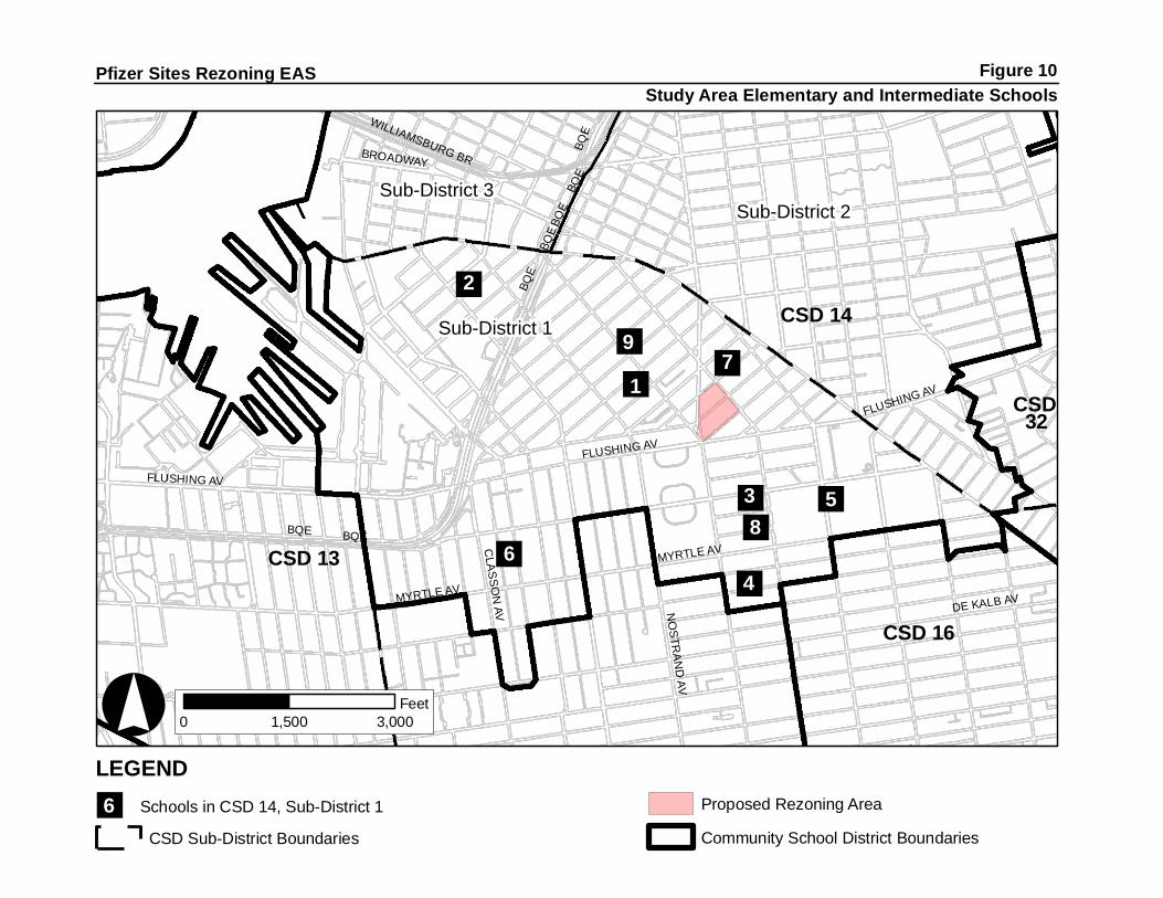
Public Schools
According to the CEQR Technical Manual, the primary study area for the analysis of elementary and intermediate schools should be the school district’s “sub‐district” in which the project is located. The project area is located within sub‐district 1 of Community School District 14. This sub‐district will constitute the study area (see Figure 10). High schools are assessed on a borough‐wide basis.
Identify and locate the public elementary and intermediate schools serving the study area defined above. Existing capacity, enrollment, and utilization data for all public elementary and intermediate schools within sub‐district 1 of Community School District 14 will be provided for the current or most recent school year, noting any specific shortages of school capacity. Similar data will be provided for Brooklyn high schools in accordance with CEQR Technical Manual guidelines.
Identify conditions that would exist in the 2019 future without the proposed action (No‐Action condition), taking into consideration projected changes in future enrollment, including those associated with other developments in the vicinity of the project area, and plans to alter school capacity either through administrative actions on the part of the New York City Department of Education or as a result of the construction of new school space. Planned new capacity projects from the DOE’s Five Year Capital Plan will not be included in the quantitative analysis unless the projects have commenced site preparation and/or construction. They may, however, be included in a qualitative discussion.
Analyze future conditions with the proposed action, adding students likely to be generated by the RWCDS to the projections for the future No‐Action condition. Project impacts will be assessed based on the difference between the future With‐Action projections and the future No‐Action projections (at the school sub‐district level for elementary and intermediate schools and borough for high schools) for enrollment, capacity and utilization in 2019.
Determine whether the proposed action would result in a significant adverse impact. A significant adverse impact may result, warranting consideration of mitigation, if the proposed action would result in: (1) a collective utilization rate of the elementary and/or intermediate schools in the sub‐district study area that is equal to or greater than 100 percent in the With‐Action condition; and (2) an increase of five percent or more in the collective utilization rate between the No‐Action and With‐Action conditions.
If significant adverse impacts are identified, mitigation measures to avoid or reduce potential significant impacts will be identified.
""
"""
""
"
"Sub-District 1
Sub-District 3Sub-District 2
CSD 14
CSD 13
CSD 16
CSD32
BQE
DE KALB AV
MYRTLE AV
FLUSHING AV
CLA
SS
ON
AV NO
STR
AN
DAV
BROADWAY
WILLIAMSBURG BR
BQE
FLUSHING AV
BQE
BQE
BQE
BQE
BQE
FLUSHING AV
MYRTLE AV
°
Pfizer Sites Rezoning EAS
0 1,500 3,000Feet
Study Area Elementary and Intermediate SchoolsFigure 10
LEGEND
" Schools in CSD 14, Sub-District 1 Proposed Rezoning Area
CSD Sub-District Boundaries Community School District Boundaries
2
6
9
17
38
4
5
6
Pfizer Sites Rezoning Draft Scope of Work for an EIS
Page 18
Libraries
Identify the local public library branch(es) serving the area within approximately three‐quarters of a mile from the project area, which is the distance that one might be expected to travel for such services. Show the identified local public library branch(es) within a ¾‐mile radius on a map.
Describe existing libraries within the study area and their information services, and user population. Information regarding services provided by branch(es) within the study area will include circulation, holdings, level of utilization, and other relevant existing conditions. Details on library operations will be based on publicly available information and/or consultation with library officials. If applicable, holdings per resident may be estimated to provide a quantitative gauge of available resources in the applicable branch libraries in order to form a baseline for the analysis.
For No‐Action conditions, projections of population change in the area and information on any planned changes in library services or facilities will be described and the effects of these changes on library services will be assessed. Using the information gathered for the existing conditions, holdings per resident in the No‐Action condition will be estimated.
Determine the effects of the addition of the population resulting from the proposed action on the study area libraries’ ability to provide information services to their users. Holdings per resident in the With‐Action condition will be estimated and compared to the No‐Action holdings estimate.
Determine whether the proposed action would result in a significant adverse impact. According to the CEQR Technical Manual, if the proposed action would increase the ¾‐mile study area population by five percent or more over No‐Action levels, and it is determined, in consultation with the appropriate library agency, that this increase would impair the delivery of library services in the study area, a significant impact may occur, warranting consideration of mitigation.
Child Care Centers
Identify existing publicly funded child care facilities (including Head Start facilities) within approximately 1.5 miles of the project area. Describe each facility in terms of its location, number of slots (capacity), and enrollment (utilization). Information will be based on publicly available information and/or consultation with the Administration for Children’s Services’ Division of Child Care and Headstart (CCHS).
For No‐Action conditions, information will be obtained on any changes planned for child care programs or facilities in the area, including closing or expansion of existing facilities and establishment of new facilities. Any expected increase in the population of children under 6 within the eligibility income limitations will be discussed as potential additional demand; and the potential effect of any population increases on demand for child care services in the study area will be assessed. The available capacity or resulting deficiency in slots and the utilization rate for the study area will be calculated for the No‐Action condition.
The potential effects of the additional eligible children resulting from the RWCDS for the proposed action will be assessed by comparing the estimated demand over capacity to the demand over capacity estimated in the No‐Action condition.
Determine whether the proposed action would result in a significant adverse impact. According to the CEQR Technical Manual, a significant adverse impact may result, warranting consideration of mitigation, if the proposed action would result in both of the following: (a) a collective utilization rate of the group child care/Head Start centers in the study area that is greater than 100 percent in the
Pfizer Sites Rezoning Draft Scope of Work for an EIS
Page 19
With‐Action condition; and (b) an increase of five percent or more in the collective utilization rate of the child care/Head Start centers in the study area between the No‐Action and With‐Action conditions.
If significant adverse impacts are identified, mitigation measures to avoid or reduce potential significant impacts will be identified.
TASK 5. OPEN SPACE
Under the CEQR Technical Manual, the threshold for an open space assessment applicable to the proposed action is more than 200 residents and 500 employees because the project area is not located within an underserved or well‐served area as defined in the CEQR Technical Manual. The proposed RWCDS, as disclosed in the EAS, would generate more than 200 residents, and therefore, would exceed the CEQR Technical Manual threshold requiring an analysis to assess potential impacts on the residential open space user population in a ½‐mile study area (see Figure 11). The proposed action and RWCDS would not result in an increase of more than 500 workers in the project area. Therefore, an assessment of potential impacts on the non‐residential (worker) population is not warranted.
The open space analysis will consider both passive and active open space resources within a residential (½‐mile radius) study area. As recommended in the CEQR Technical Manual, the study area would comprise all census tracts that have 50 percent of their area located within a ½‐mile radius of the project area, respectively. The open space analysis in the EIS will include the following sub‐tasks.
Determine characteristics of the open space user groups: residents and workers/daytime users. To determine the number of residents in the study area, 2010 census data will be compiled for census tracts comprising the residential open space study area. Because the study areas include a workforce and daytime population that may also use open spaces, the number of employees and daytime workers in the study area will also be calculated, based on reverse journey‐to‐work census data.
Inventory existing active and passive open spaces within the open space study area. The condition and usage of existing facilities will be described based on the inventory and field visits. Acreage of these facilities will be determined and total study area acreage calculated. The percentage of active and passive open space will also be calculated. A map showing the locations of open spaces keyed to the inventory will be provided.
Based on the inventory of facilities and study area populations, open space ratios will be calculated for the residential and daytime populations, and compared to City guidelines to assess adequacy. As per the CEQR Technical Manual, open space ratios are expressed as the amount of open space acreage per 1,000 user population, and will be calculated for active and passive open space, as well as for the aggregate open space.
Assess expected changes in future levels of open space supply and demand in the 2019 analysis year, based on other planned development projects within the open space study area. Any new open space or recreational facilities that are anticipated to be operational by the analysis year will also be accounted for. Open space ratios will be calculated for 2019 future No‐Action conditions and compared with existing ratios to determine changes in future levels of adequacy.
Assess the effects on open space supply and demand resulting from increased residential and worker populations added by the proposed action and associated RWCDS. The assessment of the proposed action’s impacts will be based on a comparison of open space ratios for the future No‐Action versus future With‐Action conditions. In addition to the quantitative analysis, qualitative analysis will be

485
493
527
537
389
287
261 281
535
525
283
193241235
539
549 513
503523
1237
491533
257
529
507
505511
253
531
509
255
489
285.02
285.01
259.01
259.02
BQE
PARK AV
MYRTLE AV
GREENE AV
DE KALB AVTHR
OO
PAV
FLUSHING AV
BE
DFO
RD
AV
LAFAYETTE AV
LEEAV
HART ST
GRAND ST
LEXINGTON AV
QUINCY ST
LEW
ISAV
KEAP
ST
LOR
IME
RS
T
DEVOE ST
BU
SH
WIC
KAV
GR
AH
AM
AV
VERNON AV
PENN ST
PULASKI ST
S 5 ST
CLA
SS
ON
AV
TOM
PK
INS
AV
KE
NT
AV
KOSCIUSZKO ST
CLIFTON PL
S 4 ST
HU
MB
OLD
TS
T
NO
STR
AN
DAV
BOERUM ST
SCHOLES ST
POWERS ST
LEO
NA
RD
ST
GATES AV
AINSLIE ST
HO
OPE
RST
LYNCH ST
MA
NH
ATTAN
AV
WALLABOUT ST
S 1 ST
MESEROLE ST
FRA
NK
LINAV
WILLOUGHBY AV
S 2 ST
TAA
FFEP
L
SK
ILLMA
NS
T
HEYWARD ST
RUTLEDGE ST
HEWES ST
HARRISONAV
S 3 ST
SP
EN
CE
RS
T
MONTROSE AV
MA
RC
US
GA
RV
EY
BLV
D
WA
LWO
RTH
ST
JOHNSON AVDIVISION AV
BROADWAY
VAN BUREN ST
MIDDLETON
ST
UN
ION
AV
HAV
EM
EYER
ST
WALTON
ST
GERRY ST
DR
IGG
SAV
ELLERY ST
ROSS ST
WIL
LIAM
SBU
RG
STW
WYTHE
AV
HOPKINS ST
MAR
CY
AV
BORINQUEN PL
SA
ND
FOR
DS
T
STAGG ST
WIL
LIAM
SBU
RG
STE
BEAVER ST
MONROE ST
HOPE STW
ATERBU
RYST
SEIGEL ST
RO
EBL
ING
ST
TEN EYCK ST
MC KIBBIN ST
COOK ST
RAM
P
WHIPPLE ST
EM
ER
SO
NP
L
MOORE ST
OLIV
ES
T
WA
RS
OFF
PL
PARK
ST
TEN EYCK WALKMAUJER ST
STOCKTON ST
VARET ST
RODNEY ST
STAGG WALK
GARDEN ST
DEBEVOISE ST
FAYE
TTE
ST
S5
PL
SUM
NERPL
BQEEB
EXIT32
LITTLE NASSAU ST
NEW MONTROSE AVDELM
ONICOPL
BQE
MAR
CY
AV
MC KIBBIN ST
HOPE ST
RO
DN
EY
ST
UN
ION
AV
MA
RC
YAV
ELLE
RYST
SEIGEL ST
MOORE ST
FRA
NK
LINAV
STOCKTON ST
UN
ION
AV
STAGG STS 3 ST
KENT AV
VARET ST
° 0 1,000 2,000Feet
Pfizer Sites Rezoning Figure 11Open Space Study Area
LegendRezoning Area
Open Space Study Area
Half-Mile Radius
Census Tracts
Open Space
257
Pfizer Sites Rezoning Draft Scope of Work for an EIS
Page 20
performed to determine if the changes resulting from the proposed action constitute a substantial change (positive or negative) or an adverse effect to open space conditions. The qualitative analysis will assess whether or not the study area is sufficiently served by open spaces, given the type (active vs. passive), capacity, condition, and distribution of open space, and the profile of the study area population.
If the results of the impact analysis identify a potential for a significant adverse impact, discuss potential mitigation measures.
TASK 6. SHADOWS
This chapter will examine the proposed action’s potential for significant and adverse shadows impacts pursuant to CEQR Technical Manual criteria. Generally, the potential for shadows impacts exists if an action would result in new structures or additions to buildings resulting in structures over 50 feet in height that could cast shadows on important natural features, publicly accessible open space, or on historic features that are dependent on sunlight. As a RWCDS, the proposed action would facilitate the construction of predominantly residential mixed‐use buildings on two blocks with a maximum roof height of 145 feet and a maximum total building height of approximately 157 feet (including rooftop mechanical equipment). The project area is located across the street from existing sunlight‐sensitive resources. Therefore, a preliminary assessment of shadows is warranted and will be provided in the EIS. The preliminary assessment will include the following tasks:
Develop a base map illustrating the project area in relation to publicly accessible open spaces, historic resources with sunlight‐dependent features, and natural features in the area.
Perform a screening assessment to ascertain which seasons and times of day shadows from the RWCDS could reach any sunlight‐sensitive resources.
If the possibility of new shadows reaching sunlight‐sensitive resources cannot be eliminated in the preliminary assessment, the EIS will include a detailed analysis in accordance with the 2014 CEQR Technical Manual. This will include the following tasks:
Develop a three‐dimensional computer model of the elements of the base map developed in the preliminary assessment.
Develop three‐dimensional representations of the No‐Action shadow conditions in the area as of the Build Year.
Develop a three‐dimensional representation of shadow conditions in the area with the proposed action as of the Build Year.
Determine the extent and duration of incremental shadows that would be cast on sunlight‐sensitive resources as a result of the proposed action on four representative days of the year.
Document the analysis with graphics comparing shadows resulting from the No‐Action condition with shadows resulting from the proposed action, with incremental shadows highlighted in a contrasting color.
Include a summary table listing the entry and exit times and total duration of incremental shadows on each applicable representative day for each affected sun‐sensitive resource.
Pfizer Sites Rezoning Draft Scope of Work for an EIS
Page 21
Assess the significance of any shadows impacts on sunlight‐sensitive resources (including the De Hostos Playground, Project Roots I.S. 318, any other existing or planned parks, and sunlight‐sensitive historic resources). If potential significant adverse impacts are identified, the amount of remaining sunlight on those sensitive resources as well as the types of vegetation and or recreational activities involved will be considered in reaching impact conclusions.
If any significant adverse shadow impacts are identified, identify and assess potential mitigation strategies.
In addition, the proposed action would create a new publicly accessible open space. Although action‐generated shadows cast on open spaces created by an action are not considered significant under CEQR, they should be identified and disclosed as part of the environmental review. TASK 7. HISTORIC AND CULTURAL RESOURCES The CEQR Technical Manual identifies historic resources as districts, buildings, structures, sites, and objects of historical, aesthetic, cultural, or archaeological importance. This includes designated NYC Landmarks; properties calendared for consideration as landmarks by the New York City Landmarks Preservation Commission (LPC); properties listed on the State/National Register of Historic Places (S/NR) or contained within a district listed on or formally determined eligible for S/NR listing; properties recommended by the NY State Board for listing on the S/NR; National Historic Landmarks; and properties not identified by one of the programs listed above, but that meet their eligibility requirements. According to the CEQR Technical Manual, a historic and cultural resources assessment is required if there is the potential to affect either archaeological or architectural resources. The analyses will consider the potential of the proposed action and associated RWCDS to affect historic and cultural resources as follows.
Architectural Resources
While the project area is vacant and does not include any architectural resources, the former Charles Pfizer & Company buildings at 11 Bartlett Street (now Beginning With Children Charter School) and 630 Flushing Avenue (now 630 Flushing Incubator) were previously determined to be eligible for listing on the S/NR are located nearby, and it is possible that there may be other potential architectural resources within the study area. Consistent with the CEQR Technical Manual, the historic and cultural resources assessment will include the following tasks:
Select the study area for architectural resources. This scope of work assumes that the study area for architectural resources will be approximately 400 feet beyond the project area’s boundaries.
Submit the proposed action and associated RWCDS to LPC for their review and determination regarding architectural resources, and request a preliminary determination of designated and/or eligible architectural resources within the study area.
Map and briefly describe designated architectural resources in the study area. Consistent with the guidance of the CEQR Technical Manual, designated architectural resources include: New York City Landmarks, Interior Landmarks, Scenic Landmarks, New York City Historic Districts; resources calendared for consideration as one of the above by NYCLPC; resources listed on or formally determined eligible for inclusion on the State and/or National Registers of Historic Places, or contained within a district listed on or formally determined eligible for listing on the Registers; resources recommended by the New York State Board for listing on the Registers; and National Historic Landmarks.

Pfizer Sites Rezoning Draft Scope of Work for an EIS
Page 22
Assess the potential significant adverse impacts of the proposed action on architectural resources, including visual and contextual changes as well as any direct physical impacts, on any designated and potential architectural resources. Potential effects will be evaluated through a comparison of the No‐Action condition and the future with the proposed action.
If applicable, develop measures to avoid, minimize, or mitigate any significant adverse impacts on historic and cultural resources, in consultation with NYCLPC.
This scope of work assumes there will be no state or federal actions that require review by the New York State Office of Parks, Recreation and Historic Preservation (OPRHP).
Archaeological Resources
As the proposed action and associated RWCDS would entail in‐ground disturbance, pursuant to CEQR Technical Manual guidelines, the potential impacts of the proposed action on archaeological resources will need to be analyzed for the project area. The New York City Landmarks Preservation Commission (LPC) was consulted to determine whether the project area is sensitive for archaeological resources. In an Environmental Review letter dated May 26, 2015, LPC confirmed that the site is not sensitive for archaeological resources; per CEQR Technical Manual guidelines, no further archaeological analysis will be is required for the proposed action. For informational purposes, the EIS will provide information on LPC’s Environmental Review.
TASK 8. URBAN DESIGN AND VISUAL RESOURCES
The CEQR Technical Manual indicates that there is no need to conduct an urban design analysis if a proposed project would be constructed within existing zoning envelopes, and would not result in physical changes beyond the bulk and form permitted “as‐of‐right.” The proposed action involves zoning map and zoning text amendments, which would increase the allowable density and create new zoning districts to be mapped in the project area. Therefore, a preliminary assessment of urban design and visual resources will be conducted in the EIS in order to determine whether the proposed action could cause significant change to the pedestrian experience that could disturb the vitality, walkability, or visual character of the area. The assessment will be based on CEQR Technical Manual methodologies, and include the following:
Identify a study area for the analysis of urban design and visual resources. Following the guidelines of the CEQR Technical Manual, the study area will be consistent with the ¼‐mile study area for the analysis of land use, zoning and public policy. Based on field visits, describe the project area and the urban design and visual resources of the surrounding area, using text and photographs as appropriate. A description of visual resources in the area and view corridors, if any, will also be provided.
In coordination with the land use task, describe the changes expected in the urban design and visual character of the study area due to planned development projects in the future without the proposed action (No‐Action condition).
Describe the potential changes that could occur in the urban design character of the study area as a result of the proposed action (With‐Action Condition). Assess the changes in urban design characteristics and visual resources that are expected to result from the proposed action in the project area and in the study area and evaluate the significance of the change. Photographs and/or other graphic material will be utilized, where applicable, to assess the potential effects on urban design and visual resources, including views of/to resources of visual or historic significance (landmark structures, historic districts, parks, etc.).
Pfizer Sites Rezoning Draft Scope of Work for an EIS
Page 23
A detailed analysis will be prepared if warranted based on the preliminary assessment. As described in the CEQR Technical Manual, examples of projects that may require a detailed analysis are those that would make substantial alterations to the streetscape of a neighborhood by noticeably changing the scale of buildings, potentially obstruct view corridors, or compete with icons in the skyline. The detailed analysis would describe the urban design and visual resources of the project area and the surrounding area. The analysis would describe the potential changes that could occur to urban design and visual resources in the future with the proposed action, in comparison to the No‐Action condition, focusing on the changes that could negatively affect a pedestrian’s experience of the area. If necessary, mitigation measures to avoid or reduce potential significant adverse impacts will be identified.
TASK 9. HAZARDOUS MATERIALS The objective of the hazardous materials assessment is to determine whether the project area may have been adversely affected by current or historical uses at or adjacent to the site. The proposed action would result in new residential development in areas currently zoned for manufacturing, and therefore has the potential to result in significant hazardous materials impacts. This chapter of the EIS will be prepared pursuant to 2014 CEQR Technical Manual guidelines and will include a detailed description of measures that would be taken to ensure that the potential for any impacts would be avoided. It will primarily examine the potential for impacts related to subsurface contamination, including an evaluation of the existing soil and groundwater conditions in areas that would be affected by the proposed action. The 2014 CEQR Technical Manual states that the hazardous materials assessment generally begins with a Phase I Environmental Site Assessment (ESA). In the case of the project area, the two block area of the project area has a documented history of hazardous materials conditions and has undergone hazardous materials investigations and remediation activities. In addition, the Southern Block (Block 2265, Lot 14) is subject to a Voluntary Cleanup Agreement (VCA) executed in 1997, which is under the jurisdiction of the New York State Department of Environmental Conservation (NYSDEC) Voluntary Cleanup Program (VCP). Block 2265, Lot 14 also has an executed a deed restriction that prohibits the property from being used for purposes other than industrial, commercial and/or recreation (designed to preclude contact with contaminants by humans) without the express written permission or waiver of such prohibition by NYSDEC. It further states that this prohibition is enforceable only by NYSDEC or its successor “but shall not be enforceable by any third party.” It is not yet clear whether one or both of the project area blocks would receive a hazardous materials (E) designation. If an (E) designation is a possibility a Phase I ESA must be prepared pursuant to 15 RCNY Chapter 24 and its findings disclosed in the EIS. The EIS will include a discussion of what testing, steps and standards would be applied in complying with the VCA and altering the deed restriction on the Southern Block, and will discuss, as applicable, the findings of any Phase I ESAs prepared for the project area blocks, what testing (and, if necessary, remediation and/or institutional controls) would be required on the Northern Block to ensure the proposed action would be protective of human health and the environment.

Pfizer Sites Rezoning Draft Scope of Work for an EIS
Page 24
TASK 10. WATER AND SEWER INFRASTRUCTURE
The water and sewer infrastructure assessment is important to ensure the City’s systems have adequate capacity to accommodate land use or density changes. For any new development it is critical to avoid environmental health problems such as sewer back‐ups, street flooding, or pressure reductions. The Proposed Project would result in increased demand for infrastructure services, including an increase in the demand for water and wastewater treatment services. The estimated water usage, sewage generation, and stormwater discharge rates associated with the RWCDS will be evaluated to determine that the capacity of the network is sufficient and to determine whether the proposed action would result in any significant adverse impacts. This section will also describe and account for any changes in drainage associated with the RWCDS. Water Supply
The existing water distribution system serving the project area will be described based on information
obtained from DEP’s Bureau of Water Supply and Wastewater Collection;
The existing water demand generated in the project area will be estimated;
Water demand generated in the project area by the RWCDS will be projected for future No‐Action and With‐Action conditions; and
The effects of the incremental demand on the City’s water supply system will be assessed to determine if there would be impacts to water supply or pressure. The incremental water demand will be the difference between the water demand generated in the project area by the RWCDS in the With‐Action condition and by the RWCDS in the No‐Action condition.
Wastewater and Stormwater Infrastructure
Develop the appropriate study area for assessment in conformance with CEQR guidelines and in consultation with DEP;
Describe the existing stormwater drainage system and surfaces in the project area and the amount of stormwater generated by it using DEP’s volume calculation worksheet;
Describe the existing sewer system serving the project area based on records obtained from DEP;
Describe any changes to the stormwater drainage plan, sewer system, and surface area expected in the No‐Action and With‐Action conditions;
Assess future stormwater generation in the project area to determine the proposed action potential to result in impacts; and
Estimate the sanitary sewer generation by the RWCDS in the project area.
According to the CEQR Technical Manual and in consultation with DEP, a more detailed assessment may be required if increased sanitary or stormwater discharges from the RWCDS associated with the Proposed Actions are predicted to affect the capacity of portions of the existing sewer system, exacerbate combined sewer overflow (CSO) volumes/frequencies, or contribute greater pollutant loadings in stormwater discharged to receiving water bodies.
Pfizer Sites Rezoning Draft Scope of Work for an EIS
Page 25
TASK 11. ENERGY
An EIS must include a discussion of the effects of a proposed action on the use and conservation of energy, if applicable and significant, in accordance with CEQR. In most cases, an action does not need a detailed energy assessment, but its operational energy is projected. A detailed energy assessment is limited to actions that may significantly affect the transmission or generation of energy. For other actions, in lieu of a detailed assessment, the estimated amount of energy that would be consumed annually as a result of the day‐to‐day operation of the buildings and uses resulting from an action is disclosed, as recommended in the 2014 CEQR Technical Manual. An analysis of the anticipated additional demand from the Proposed Actions’ RWCDS will be provided in the EIS. The EIS will disclose the projected amount of energy consumption during long‐term operation resulting from the Proposed Actions. The projected amount of energy consumption during long‐term operation (for projected development sites) will be estimated based on the average and annual whole‐building energy use rates for New York City (per Table 15‐1 of the CEQR Technical Manual). If warranted, the Mayor’s Office of Sustainability (MOS) and/or the power utility serving the area (Con Edison of New York) will be consulted.
TASK 12. TRANSPORTATION
The proposed action and associated RWCDS would generate new vehicular travel and parking demand, as well as generate additional pedestrian trips and trips by subway and local bus in the study area. These new trips have the potential to affect the area’s transportation systems beginning in the proposed analysis year of 2019. Based on preliminary estimates, the RWCDS is expected to generate more than 50 additional vehicular trips in the weekday AM, midday, and PM peak hours, and the Saturday midday peak hour. The RWCDS is also expected to generate more than 200 subway trips in all peak hours, and more than 200 project‐generated pedestrian trips in all peak hours. Therefore, the transportation studies for the EIS will include the following analyses.
Travel Demand and Screening Assessment
Detailed trip estimates will be prepared using standard sources, including the CEQR Technical Manual, U.S. census data, approved studies, and other references. The trip estimates (Level‐1 screening assessment) will be summarized by peak hour, mode of travel, as well as person and vehicle trips. The trip estimates will also identify the number of peak hour person trips made by transit and the numbers of pedestrian trips traversing the area’s sidewalks, corner reservoirs, and crosswalks. The results of these estimates will be summarized in a Transportation Planning Factors and Travel Demand Forecast memorandum for review and concurrence by the lead agency. In addition to trip estimates, detailed vehicle, pedestrian and transit trip assignments (Level‐2 screening assessment) will be prepared to validate the intersections and pedestrian/transit elements selected for undertaking quantified analysis.
Traffic
Under CEQR Technical Manual criteria, significant adverse impacts are considered unlikely and a detailed traffic assessment is typically not warranted if a proposed project would generate fewer than 50 new vehicle trips in any peak hour. Based on preliminary estimates, the RWCDS is expected to generate an
Pfizer Sites Rezoning Draft Scope of Work for an EIS
Page 26
increase of approximately 152 vehicular trips in the weekday AM, 144 in the midday, and 184 in the PM peak hours, and 176 in the Saturday midday peak hour, compared to No‐Action conditions. Because the forecasted levels of new vehicular travel demand generated by the RWCDS would exceed the 50‐trip CEQR Technical Manual analysis threshold, the EIS will provide a detailed traffic analysis focusing on these peak hours.
Based on preliminary estimates and traffic assignment, a total of four (4) intersections have been selected for the analysis of traffic conditions. These intersections, listed below, are where traffic generated by the RWCDS is expected to be most concentrated based on the preliminary traffic assignment.
1. Wallabout Street at Union Avenue (unsignalized) 2. Flushing Avenue/Gerry Street at Union/Marcy Avenues (signalized) 3. Gerry Street at Harrison Avenue (signalized) 4. Wallabout Street at Harrison Avenue (unsignalized)
The EIS traffic analysis will include the following tasks:
Define a traffic study area to account for the principal travel corridors to/from the project area. Based on a preliminary travel demand forecast and vehicle trip assignments, it is anticipated that a total of approximately four (4) intersections were selected for detailed analysis for potential impacts during the weekday AM, midday and PM peak periods and the Saturday midday period (refer to the list of intersections above).
Conduct traffic counts at traffic analysis locations via a mix of automatic traffic recorder (ATR) machine counts and manual intersection turning movement counts. ATRs will provide continuous 24‐hour traffic volumes for a minimum of nine days (including two weekends) along the principal corridors serving the project area. Manual turning movement counts will be conducted during the weekday AM, midday and PM and Saturday midday peak periods. Where applicable, available information from recent studies in the vicinity of the study area will be compiled, including data from such agencies as the New York City Department of Transportation (NYCDOT) and NYCDCP.
Conduct any required travel speed and delay studies and vehicle classification counts along principal corridors in the study area to provide supporting data for any air quality and noise analyses. These speed‐and‐delay studies and vehicle classification counts will be conducted in conjunction with the traffic volume counts.
Inventory physical and operational data as needed for capacity analysis purposes at each of the analyzed intersections. The data collected will be consistent with current CEQR Technical Manual guidelines and will include such information as street widths, number of traffic lanes and lane widths, pavement markings, turn prohibitions, parking regulations, and signal phasing and timing data as provided by NYC Department of Transportation.
Using Highway Capacity Software (HCS) + Version 5.5 methodologies, determine existing traffic conditions at each analyzed intersection including capacities, volume‐to‐capacity (v/c) ratios, average control delays per vehicle and levels of service (LOS) for each lane group and intersection approach, and for the intersection overall.
Identify planned projects that would be developed in the area in the future without the proposed action (the No‐Action condition) and determine the associated future No‐Action travel demand generated by these projects. The future traffic volumes from No‐Action projects will be estimated using published environmental assessments or forecasted based on current CEQR Technical Manual

Pfizer Sites Rezoning Draft Scope of Work for an EIS
Page 27
guidelines, Census data, and/or data from other secondary sources. An annual growth rate of 0.5 percent per year for the first five years and 0.25 percent per year thereafter will also be applied to existing traffic volumes to account for general background growth through 2019 as per CEQR Technical Manual guidelines. Mitigation measures accepted for No‐Action projects will also be reflected in the future No‐Action traffic network as will any relevant initiatives planned by NYCDOT and other agencies. No‐Action traffic volumes will be determined, v/c ratios and levels of service will be calculated, and congested intersections will be identified.
Based on available sources, U.S. Census data, standard references, and other EIS documents, forecast the travel demand generated by the RWCDS’s residential and local retail uses, and the modes of transportation expected to be used for these trips.
Determine the volume of vehicle traffic expected to be generated by the RWCDS, assign that volume of traffic in each analysis period to the approach and departure routes likely to be used, and prepare balanced traffic volume networks for the future condition with the proposed action (the With‐Action condition) for each analysis period.
Determine the resulting v/c ratios, delays and levels of service for the future With‐Action condition, and identify significant traffic impacts in accordance with current CEQR Technical Manual criteria.
Identify and evaluate potential traffic mitigation measures, as appropriate, for all significantly impacted locations in the study area in consultation with the lead agency and NYCDOT. Potential traffic mitigation could include both operational and physical measures such as changes to lane striping, curbside parking regulations and traffic signal timing and phasing, roadway widening, and new traffic signal installations. Where impacts cannot be mitigated, they will be described as unavoidable adverse impacts.
Parking
Based on preliminary estimates, parking demand generated by the RWCDS is expected to be fully accommodated on‐site in accessory garages. Therefore, the parking analysis will focus on parking demand and supply at the project area. Parking demand generated by the projected residential and local retail uses would be estimated and temporal arrival and departure patterns established using standard professional references and/or previously approved factors. Weekday and Saturday parking accumulation profiles will be developed for the project area.
Transit
Transit analyses typically focus on the weekday AM and PM commuter peak hours, as it is during these periods that overall demand on the subway and bus systems is usually highest. The subway stations selected for analysis are determined based upon projected subway trip assignment patterns and the CEQR Technical Manual analysis threshold of 200 incremental trips per hour at any one station. An analysis of MTA New York City Transit (NYC Transit) bus routes is similarly considered warranted based on CEQR Technical Manual analysis thresholds of 200 total local bus trips in any one peak hour, and 50 incremental trips per direction per hour on any one bus route.
Based on preliminary travel demand forecasts, the RWCDS is expected to generate an increase (compared to No‐Action Conditions) of 366, 242, 425, and 375 subway trips during the weekday AM, midday and PM and Saturday midday peak hours, respectively. The RWCDS is expected to exceed the CEQR screening
Pfizer Sites Rezoning Draft Scope of Work for an EIS
Page 28
threshold at the Lorimer Station on the BMT Jamaica Line, which is served by the J train at all times except rush hours in the peak direction and the M train at all times except nights.
Based on preliminary travel demand forecasts, the RWCDS is expected to result in an increase (compared to the No‐Action) of 67, 152, 119, and 123 bus riders in the weekday AM, midday, PM and Saturday midday peak periods, respectively. Bus trips associated with the RWCDS are expected to be below the CEQR Technical Manual thresholds to warrant the need for any detailed bus analysis (i.e., the RWCDS is expected to generate fewer than 200 local bus trips in any peak hour).
Subway
The EIS analysis of the Lorimer Street subway station will include the following tasks:
Conduct field counts during the weekday AM and PM peak hours to document existing usage at the Lorimer Street subway station, focusing on those station elements (street stairs and fare control areas) most likely to be used by project‐generated demand. Determine existing peak hour levels of service.
Assess conditions at analyzed station elements in the 2019 analysis year in the future without the proposed action (the No‐Action condition) based on annual background growth rates specified in the CEQR Technical Manual and anticipated demand from known developments in the vicinity of the project area.
Forecast future subway demand generated by the RWCDS, assign trips to individual station elements, and add them to the future No‐Action volumes to determine conditions in the future with the proposed action. Identify significant adverse impacts based on CEQR Technical Manual criteria.
Mitigation needs and potential improvements will be identified, as appropriate, in conjunction with the lead agency and NYC Transit. Where impacts cannot be mitigated, they will be described as unavoidable adverse impacts.
Pedestrians
Based on a preliminary travel demand, the RWCDS would result in a net increase of more than the 200‐trip CEQR Technical Manual analysis threshold to sidewalks, corner areas, and crosswalks in the immediate vicinity of the project area during the weekday midday and PM, and Saturday midday peak hours. The RWCDS is expected to generate a total of approximately 884, 2,294, 1,681 and 1,776 pedestrian trips during the weekday AM, midday, PM, and Saturday midday peak hours, respectively. These trips would include walk‐only trips as well as pedestrian trips en route to and from area transit facilities (subway stations and bus stops). Project‐generated pedestrian demand is expected to be most concentrated on sidewalks and crosswalks in the immediate vicinity of the project area, and along Wallabout Street between the project area and Lorimer Street subway station.
A quantitative analysis of pedestrian conditions will therefore be prepared focusing on those sidewalks, corner areas and crosswalks in the vicinity of the project area expected to be used by 200 or more project‐generated pedestrian trips during one or more peak hours. A total of 11 sidewalks, 28 crosswalks, and 25 corner areas have been selected for the analysis of pedestrian conditions. These locations, listed below, are where pedestrian trips are expected to be most concentrated, including sidewalks, corner areas and crosswalks providing access to entrances and along corridors to nearby transit facilities.
Pfizer Sites Rezoning Draft Scope of Work for an EIS
Page 29
Sidewalks North sidewalk on Gerry Street between Union and Harrison Avenues
South sidewalk on Wallabout Street between Union and Harrison Avenues
South sidewalk on Wallabout Street between Harrison and Throop Avenues
North sidewalk on Wallabout Street between Union and Harrison Avenues
North sidewalk on Wallabout Street between Harrison and Throop Avenues
North sidewalk on Wallabout Street between Throop Avenue and Broadway
South sidewalk on Walton Street between Union and Harrison Avenues
East sidewalk on Union Avenue between Gerry and Wallabout Streets
East sidewalk on Union Avenue between Wallabout and Walton Streets
West sidewalk on Harrison Avenue between Gerry and Wallabout Streets
West sidewalk on Harrison Avenue between Wallabout and Walton Streets
Crosswalks Walton Street at Union Avenue – North Crosswalk
Walton Street at Union Avenue – East Crosswalk
Walton Street at Union Avenue – South Crosswalk
Wallabout Street at Union Avenue – North Crosswalk3,4
Wallabout Street at Union Avenue – East Crosswalk5
Wallabout Street at Union Avenue – South Crosswalk5,6
Flushing Avenue/Gerry Street at Marcy Avenue/Union Avenue – North Crosswalk
Flushing Avenue/Gerry Street at Marcy Avenue/Union Avenue – East Crosswalk
Flushing Avenue/Gerry Street at Marcy Avenue/Union Avenue – South Crosswalk
Flushing Avenue/Gerry Street at Marcy Avenue/Union Avenue – West Crosswalk
Walton Street at Harrison Avenue – North Crosswalk5
Walton Street at Harrison Avenue – East Crosswalk5
Walton Street at Harrison Avenue – South Crosswalk5,6
Walton Street at Harrison Avenue – West Crosswalk5
Wallabout Street at Harrison Avenue – North Crosswalk5,6
Wallabout Street at Harrison Avenue – East Crosswalk5
Wallabout Street at Harrison Avenue – South Crosswalk5,6
Wallabout Street at Harrison Avenue – West Crosswalk5
Gerry Street at Harrison Avenue – North Crosswalk
Gerry Street at Harrison Avenue – East Crosswalk
Gerry Street at Harrison Avenue – South Crosswalk
Gerry Street at Harrison Avenue – West Crosswalk
Wallabout Street at Throop Avenue – North Crosswalk5
Wallabout Street at Throop Avenue – East Crosswalk5
Wallabout Street at Throop Avenue – South Crosswalk5
Wallabout Street at Throop Avenue – West Crosswalk5
Wallabout Street at Broadway – North Crosswalk
Wallabout Street at Broadway – West Crosswalk
3 Intersection is unsignalized; element will only be analyzed if intersection requires a signal in the With‐Action condition. 4 Crosswalk is not striped.
Pfizer Sites Rezoning Draft Scope of Work for an EIS
Page 30
Corner Areas
Walton Street at Union Avenue – Northeast Corner
Walton Street at Union Avenue – Southeast Corner
Wallabout Street at Union Avenue – Northeast Corner5
Wallabout Street at Union Avenue – Southeast Corner5
Flushing Avenue/Gerry Street at Marcy Avenue/Union Avenue – Northwest Corner
Flushing Avenue/Gerry Street at Marcy Avenue/Union Avenue – Northeast Corner
Flushing Avenue/Gerry Street at Marcy Avenue/Union Avenue – Southwest Corner
Flushing Avenue/Gerry Street at Marcy Avenue/Union Avenue – Southeast Corner
Walton Street at Harrison Avenue – Northwest Corner5
Walton Street at Harrison Avenue – Northeast Corner5
Walton Street at Harrison Avenue – Southwest Corner5
Walton Street at Harrison Avenue – Southeast Corner5
Wallabout Street at Harrison Avenue – Northwest Corner5
Wallabout Street at Harrison Avenue – Northeast Corner5
Wallabout Street at Harrison Avenue – Southwest Corner5
Wallabout Street at Harrison Avenue – Southeast Corner5
Gerry Street at Harrison Avenue – Northwest Corner
Gerry Street at Harrison Avenue – Northeast Corner
Gerry Street at Harrison Avenue – Southwest Corner
Gerry Street at Harrison Avenue – Southeast Corner
Wallabout Street at Throop Avenue – Northwest Corner5
Wallabout Street at Throop Avenue – Northeast Corner5
Wallabout Street at Throop Avenue – Southwest Corner5
Wallabout Street at Throop Avenue – Southeast Corner5
Wallabout Street at Broadway – Northwest Corner
The pedestrian analysis will evaluate existing and No‐Action conditions during the weekday AM, midday and PM and Saturday midday peak hours, and the potential for incremental demand from the RWCDS to result in significant adverse impacts based on current CEQR Technical Manual criteria. Potential measures to mitigate any significant adverse pedestrian impacts will be identified and evaluated, as warranted, in consultation with the lead agency and NYCDOT.
Vehicular and Pedestrian Safety
Vehicular and pedestrian safety issues in the area will also be examined. Accident data for the study area intersections from the most recent three‐year period will be obtained from NYCDOT. These data will be analyzed to determine if any of the studied locations may be classified (using CEQR criteria) as high vehicle crash or high pedestrian/bike accident locations and whether trips and changes resulting from the proposed action would adversely affect vehicular and pedestrian safety in the area. If any high crash locations are identified, feasible improvement measures will be explored to alleviate potential safety issues.
Pfizer Sites Rezoning Draft Scope of Work for an EIS
Page 31
TASK 13. AIR QUALITY
CEQR Technical Manual criteria require an air quality assessment for actions that can result in either significant mobile source or stationary source air quality impacts. Mobile source impacts could arise when an action increases or causes a redistribution of traffic, creates any other mobile sources of pollutants, or adds new uses near existing mobile sources. Stationary source impacts could occur with actions that create new stationary sources or pollutants, such as emission stacks for industrial plants, hospitals, or other large institutional uses, or a building’s boilers, that can affect surrounding uses; when they add uses near existing or planned future emissions stacks, and the new uses might be affected by the emissions from the stacks, or when they add structures near such stacks and those structures can change the dispersion of emissions from the stacks so that they begin to affect surrounding uses. Mobile Source Analysis
Carbon monoxide (CO) and particulate matter (PM) are the primary pollutants of concern for microscale mobile source air quality analyses, including assessments of roadway intersections and parking lots/ garages. A mobile source screening analysis will be conducted to determine if the number of project‐generated vehicle trips would exceed the CEQR Technical Manual carbon monoxide (CO) analysis screening threshold of 170 vehicles in any peak hour at any locations within the study area and also if the number of heavy duty trucks or equivalent vehicle trips would exceed the City’s current interim guidance criteria for requiring an analysis of fine particulate matter (PM2.5). If traffic is found to be higher than screening thresholds, a mobile source analysis would be conducted per the CEQR Technical Manual standards. The CEQR Technical Manual also requires analysis of both CO and PM for parking facilities. As noted above, the RWCDS assumes that a below‐grade, mechanically‐ventilated accessory parking garage with a single cellar level would be provided on each block of the project area, providing a total of 477 projected accessory parking spaces. An air quality analysis will be conducted to estimate potential impacts of the proposed parking garages following the appropriate CEQR guidelines. It is assumed that predominantly gasoline‐fueled autos would use these facilities and therefore an analysis of CO and PM concentrations is warranted. The maximum total 8‐hour CO concentration (i.e., including garage vent impact, street traffic contributions, and background concentration) will be estimated using the approach specified in the CEQR Technical Manual and compared to the 8‐hr CO NAAQS of 9.0 ppm. The CEQR Spreadsheet for garage CO and/or PM analyses will be updated using MOVES emission factors. PM impacts would be evaluated in accordance with CEQR Technical Manual guidelines.
Stationary Source Analysis
The stationary air quality analysis will examine potential stationary source impacts from the RWCDS’s HVAC systems on proposed and surrounding land uses and the impacts of nearby industrial sources on sensitive uses associated with the projected development.
HVAC Screening
A screening analysis will be performed to determine whether emissions from any on‐site fuel fired heating ventilation and air conditioning systems (HVAC) are significant. The screening analysis will use the procedures outlined in the 2014 CEQR Technical Manual. The procedure involves determining the distance
Pfizer Sites Rezoning Draft Scope of Work for an EIS
Page 32
(from the exhaust point) within which potential significant impacts may occur, on elevated receptors (such as operable windows) that are of an equal or greater height when compared to the height of the RWCDS’s HVAC exhausts. The distance within which a significant impact may occur is dependent on a number of factors, including the height of the discharge, type(s) of fuel burned and development size. As a first step, a screening analysis of fuel oil no. 2 will be conducted. The pollutant of concern for the fuel oil no. 2 screening is SO2, per CEQR Technical Manual Air Quality Appendix Figure 17‐6 (nomograph). If the fuel oil no. 2 screening is exceeded then a screening analysis of natural gas will be conducted. The pollutant of concern for the natural gas screening is NO2, per CEQR Technical Manual Air Quality Appendix Figure 10‐8 (nonograph). Based on the screening analysis, analyze the project’s potential impacts on existing and proposed developments to analyze project‐on‐project and project‐on‐existing impacts from individual buildings for natural gas using the AERMOD model and five years of meteorological data from LaGuardia Airport (which is the closest airport to the project area). Relevant pollutants would include NO2, SO2 PM10 and PM2.5. Additionally, the potential combined impacts from clusters of HVAC emissions (i.e., HVAC emissions from buildings resulting from the proposed action of approximately the same height that are located in close proximity to one another) to significantly impact existing land uses and other buildings resulting from the proposed action. Clusters will be selected based on the sizes of the buildings that comprise the cluster, proximity of the cluster buildings to each other, and the difference in building heights no more than 10 to 15 feet with no city street in between.
Air Toxics Analysis
The RWCDS would include up to approximately 1,147 residential units, a new sensitive receptor, and there are manufacturing/industrial uses within 400 feet of the project area, therefore, an industrial source air quality analysis, as detailed in the 2014 CEQR Technical Manual, would be required. A survey of land uses surrounding the project area will be conducted to determine the potential for impacts from industrial emissions. The survey will determine if there are any processing or manufacturing facilities within 400 feet of the project area. A copy of the air permits for each of these facilities will be requested from the NYCDEP Bureau of Environmental Compliance (BEC). A review of NYSDEC Title V permits and the EPA Envirofacts database will also be performed to identify any federal or state‐permitted facilities within 1,000 feet of the project area. If permit information on any emissions from processing or manufacturing facilities are identified as a result of the survey and permit review, a cumulative impact analysis will be performed for multiple sources that emit the same air contaminant. Predicted concentrations of these compounds will be compared to NAAQS and NYSDEC DAR‐1 guideline values for short‐term (SGC) and annual (AGC) averaging periods. In the event that violations of standards are predicted, measures to reduce pollutant levels to within standards will be examined. Potential cumulative impacts of multiple air contaminants will be determined based on the EPA’s Hazard Index Approach for non‐carcinogenic compounds and using the EPA’s Unit Risk Factors for carcinogenic compounds. Both methods are based on equations that use EPA health risk information (established for individual compounds with known health effects) to determine the level of health risk posed by specific ambient concentrations of that compound. The derived values of health risk are additive and can be used to determine the total risk posed by multiple air contaminants.
Large and Major Source Analysis
An analysis of any existing large and major source(s) of emissions (major sources are identified as those sources located at Title V facilities that require Prevention of Significant Determination permits and large sources are identified as sources at facilities which require a State facility permit) identified within 1,000 feet of the project area will be performed to assess their potential effects on the project area. Predicted
Pfizer Sites Rezoning Draft Scope of Work for an EIS
Page 33
criteria pollutant concentrations will be predicted using the AERMOD model compared with NAAQS for NO2, SO2, and PM10, as well as applicable criteria for PM2.5. If the results of any of the above air quality analyses identify a potential for a significant adverse impact, potential mitigation measures will be discussed in the EIS.
TASK 14. GREENHOUSE GAS EMISSIONS AND CLIMATE CHANGE
The proposed action and associated RWCDS would exceed the CEQR Technical Manual threshold of 350,000 sf of development, and therefore, a Greenhouse Gas (GHG) emissions consistency assessment will be included as a separate chapter in the EIS. In accordance with the CEQR Technical Manual, an assessment of the consistency with the City’s established GHG reduction goal will be performed.
Sources of GHG from the RWCDS will be identified. The pollutants for analysis will be discussed, as well as the various city, state, and federal goals, policy, regulations, standards and benchmarks for GHG emissions.
Fuel consumption will be estimated for the RWCDS based on the calculations of energy use estimated for the project in the “Energy” screening analysis conducted as part of the EAS document.
GHG emissions associated with project‐related traffic will be estimated for the RWCDS using data from the transportation analysis. A calculation of Vehicle Miles Traveled (VMT) will be prepared.
The types of construction materials and equipment proposed will be discussed along with opportunities for alternative approaches that may serve to reduce GHG emissions associated with construction.
A qualitative discussion of stationary and mobile sources of GHG emissions will be provided in conjunction with a discussion of goals for reducing GHG emissions to determine if the proposed action is consistent with GHG reduction goals, including building efficient buildings, use of clean power, transit‐oriented development and sustainable transportation, reduction of construction operations emissions, and use of building materials with low carbon intensity.
As the project area is located within the NYC Coastal Zone, the 2020s 500‐year flood zone, the 2050s 100‐year flood zone, and the 2050 500‐year flood zone, a Climate Change assessment will be provided in the EIS. The Climate Change assessment will be performed in accordance with the CEQR Technical Manual.
Projections for the future sea level rise and, to the extent available, likely future flood zone boundaries projected for the area of the site for different years within the expected life of the development will be provided.
Any city, state, or federal initiatives to improve coastal resilience, such as those set forth in the Special Initiative for Rebuilding and Resiliency (SIRR) Report, “A Stronger, More Resilient New York,” will be discussed if they have the potential to affect the project area.
An analysis of consistency with policy 6.2 of the revised (and CPC and City Council approved) WRP will be provided.
If the results of the greenhouse gas emissions and climate change analyses identify a potential for a significant adverse impact, potential mitigation measures will be discussed.
Pfizer Sites Rezoning Draft Scope of Work for an EIS
Page 34
TASK 15. NOISE
For the proposed action, there are two major areas of concern regarding noise: (1) the effect the proposed action and associate RWCDS would have on noise levels in the adjacent community; and (2) the level of building attenuation necessary to achieve interior noise levels that satisfy CEQR requirements.
A screening assessment will be performed to determine whether there are any locations where there is the potential for the proposed action and associated RWCDS to result in significant noise impacts (i.e., doubling of Noise PCEs) due to project‐generated traffic.
The noise analysis will therefore focus on the level of building attenuation necessary to meet CEQR interior noise level requirements. The building attenuation study will be an assessment of noise levels in the surrounding area associated primarily with traffic and nearby uses and their potential effect on the RWCDS as follows:
Based on the traffic studies, perform a screening assessment to determine whether there are any locations where there is the potential for the RWCDS to result in significant noise impacts (i.e., doubling of Noise PCEs) due to project‐generated traffic. If it is determined that Noise PCEs would double at any sensitive receptor, a detailed analysis would be conducted in accordance with the CEQR Technical Manual guidelines.
Appropriate noise descriptors for building attenuation purposes would be selected. Based on CEQR criteria, the noise analysis would examine the L10, and 1‐hour equivalent (Leq(1)) noise levels.
Existing noise levels will be measured in the project area; these measurements will include background noise from existing sources in the study area. Measurements will be made at up to six (6) receptor locations adjacent to the project area. At each receptor site, 20‐minute measurements will be performed during typical weekday AM, midday, and PM peak periods and during the Saturday midday peak period. The location adjacent to De Hostos school/playground will be monitored during the school dismissal/bus departure weekday period. L1, L10, L50, L90, Lmin, and Lmax values will be recorded. L10 values will be used to determine conformance with CEQR guideline levels. Figure 12 shows these monitoring locations.
The results of the noise measurement program will be analyzed and tabulated. Traffic classification counts during the monitoring period will be tabulated. Monitored noise levels will be adjusted to existing noise levels using existing traffic volumes.
Following procedures outlined in the CEQR Technical Manual for assessing mobile source noise impacts, future No‐Action and With‐Action noise levels will be estimated at the noise receptor locations based on acoustical fundamentals. All projections will be made with Leq noise descriptor.
Determine the level of attenuation necessary to satisfy CEQR criteria. The CEQR Technical Manual provides recommended levels of building attenuation to achieve acceptable levels of interior noise (which are assumed to be 45 dBA L10(1) for residential uses and 50 dBA L10(1) for office and retail uses). The level of building attenuation necessary to satisfy CEQR requirements is a function of exterior noise levels and will be determined. Projected future noise levels will be compared to appropriate standards and guideline levels.
As necessary, recommendations regarding general noise attenuation measures needed for the RWCDS to achieve compliance with standards and guideline levels will be made.
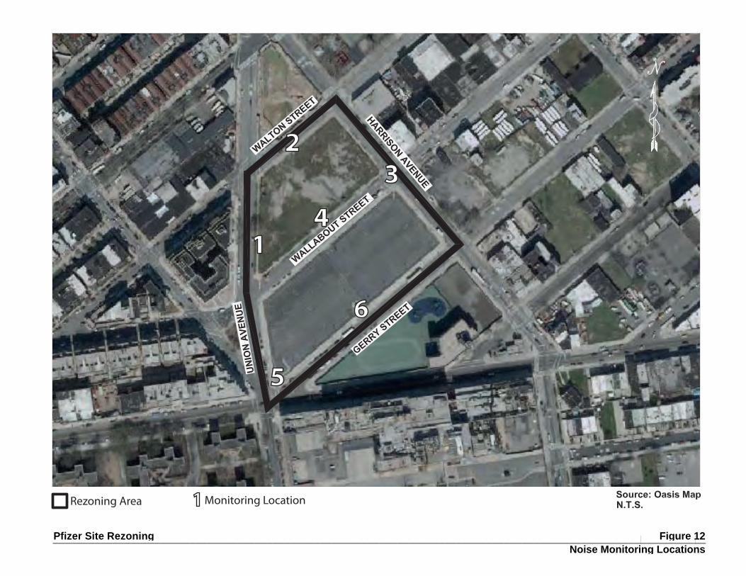
Pfizer Site Rezoning
1
23
4
5
6
1Monitoring LocationRezoning Area
Figure 12 Noise Monitoring Locations
______________________________________________________________________________________________________________
Pfizer Sites Rezoning Draft Scope of Work for an EIS
Page 35
If the results of the impact analysis identify a potential for a significant adverse impact, discuss potential mitigation measures. If necessary, recommend measures to attain acceptable interior noise levels and/or reduce noise impacts to acceptable levels.
TASK 16. PUBLIC HEALTH
According to the CEQR Technical Manual, public health is the organized effort of society to protect and improve the health and well‐being of the population through monitoring; assessment and surveillance; health promotion; prevention of disease, injury, disorder, disability and premature death; and reducing inequalities in health status. The goal of CEQR with respect to public health is to determine whether adverse impacts on public health may occur as a result of a proposed action, and if so, to identify measures to mitigate such effects.
According to the guidelines of the CEQR Technical Manual, a public health assessment may be warranted if an unmitigated significant adverse impact is identified in certain CEQR analysis areas, such as air quality, hazardous materials, or noise. If unmitigated significant adverse impacts are identified in any of these technical areas and the lead agency determines that a public health assessment is warranted, an analysis will be provided for the specific technical area or areas in accordance with CEQR guidelines.
TASK 17. NEIGHBORHOOD CHARACTER
The character of a neighborhood is established by numerous factors, including land use patterns, the characteristics of its population and economic activities, the scale of its development, the design of its buildings, the presence of notable landmarks, and a variety of other physical features that include traffic and pedestrian patterns, noise levels, etc. The proposed action and associated RWCDS have the potential to alter certain constituent elements of the surrounding area’s neighborhood character, including traffic and noise levels, and therefore an analysis will be provided in the EIS. The chapter will summarize changes that can be expected in the character of the neighborhood in the future without the proposed action (No‐Action condition) as well as describing the proposed action’s impacts on neighborhood character. Subtasks will include:
Describe the predominant factors that contribute to defining the character of the neighborhood, drawing on relevant EIS chapters.
Summarize changes in the character of the neighborhood that can be expected in the 2019 future No‐Action Condition based on planned development projects, public policy initiatives, and planned public improvements, as applicable.
Summarize changes in the character of the neighborhood that can be expected in the future With‐Action condition, based on the RWCDS, and compare to the future No‐Action condition. A qualitative assessment will be presented that will include a description of the potential effects of the proposed action and associated RWCDS on neighborhood character.
If the results of the assessment identify a potential for a significant adverse impact, potential mitigation measures will be discussed in the EIS.
TASK 18. CONSTRUCTION
Construction impacts, though temporary, can have a disruptive and noticeable effect on the adjacent community, as well as people passing through the area. Construction impacts are usually important when
Pfizer Sites Rezoning Draft Scope of Work for an EIS
Page 36
construction activity has the potential to affect traffic conditions, archaeological resources and the integrity of historic resources, community noise patterns, air quality conditions, and mitigation of hazardous materials. For the EIS, the construction schedule and logistics for the RWCDS will be described, along with a discussion of the likely staging areas, anticipated construction activities and equipment, and estimates of construction workers and truck deliveries. In addition, given the presence of the below‐grade G subway line extending beneath Union Avenue along the project area’s western edge, as well as entrances to the line’s Flushing Avenue subway station adjacent to the project area at the multi‐leg intersection of Union Avenue, Gerry Street, Marcie Avenue, and Flushing Avenue, a discussion of potential construction‐period effects on these facilities would also be provided. The analysis will be based on the peak construction period of the RWCDS. Technical areas to be analyzed include the following:
Transportation Systems. The preliminary assessment will consider potential losses in lanes, sidewalks, on‐street parking, and effects on other transportation services, if any, during the construction of the proposed project.
• Transportation Systems. The preliminary assessment will consider potential losses in lanes, sidewalks, on‐street parking, and effects on other transportation services, if any, during the construction of the proposed project. It will also identify the construction‐period increase in vehicle trips from construction workers and deliveries. A reasonable worst‐case peak construction year (or years, if applicable) will be selected for the assessment of potential transportation‐related construction impacts and a determination of likely required mitigation measures. Based on the conclusions of the preliminary assessment, including estimates for construction workers and truck deliveries, a detailed construction traffic analysis may be required for weekday construction peak hours to determine the potential for construction‐related impacts. If warranted, the number of intersections selected for quantitative analysis will be finalized (or modified) based on a comparison of the construction‐related traffic to the traffic assumed in the operational traffic analysis and the CEQR Technical Manual for Level 1 and 2 screenings for construction traffic once construction details are finalized. In addition, construction worker parking demand will be estimated and compared to the area’s parking resources. For transit and pedestrians, most construction‐related trips would be made outside of commuter peak hours during which background levels are considerably lower. If the preliminary assessment concludes that further analysis is warranted, a detailed construction period analysis of transit and/or pedestrian conditions would be prepared following the guidelines of the CEQR Technical Manual.
• Air Quality. Construction that lasts two or more years has the potential to result in air quality impacts. As the project’s construction period is assumed to be two years, a quantitative construction analysis will be conducted for the proposed project in accordance with CEQR Technical Manual criteria. The construction air quality impact section will address both mobile air source emissions from construction equipment and worker and delivery vehicles, and fugitive dust emissions. This analysis will apply measures to reduce impacts consistent with any developer commitments and may include components such as: diesel equipment reduction; clean fuel; best available tailpipe reduction technologies; utilization of equipment that meets specified emission standards; and fugitive dust control measures, among others. The analysis will review the projected activity and equipment in the context of intensity, duration, and location of emissions relative to nearby sensitive locations.
Noise. Appropriate recommendations will be made to comply with DEP Rules for Citywide Construction Noise Mitigation and the New York City Noise Control Code. The analysis will review the projected activity and equipment in the context of intensity, duration, and location of noise relative to nearby sensitive locations, and, if necessary, quantitative analyses may be conducted. As warranted based on the analysis, identify any project‐specific control measures required will be identified to further reduce construction noise. The potential for vibrations caused by construction
Pfizer Sites Rezoning Draft Scope of Work for an EIS
Page 37
activities to damage nearby buildings and other resources will be discussed, and, if necessary, mitigation measures to minimize vibrations will be examined
Hazardous Materials. In coordination with the work performed for the hazardous materials task above, the EIS will contain a summary of actions to be taken during project construction to limit exposure of construction workers, residents and nearby workers to potential contaminants, including preparation of a Construction Health and Safety Plan (CHASP) that would be submitted to NYCDEP for approval.
Historic and Cultural Resources. In coordination with the work performed for historic resources above, identify the potential for construction‐period impacts, and summarize actions to be taken during construction to protect any adjacent historic resources from potential construction impacts.
Other technical areas. As appropriate, the EIS will discuss other areas of environmental assessment for potential construction‐related impacts.
TASK 19. MITIGATION
Where significant adverse impacts have been identified in any of the above tasks, measures to mitigate those impacts will be described. These measures will be developed and coordinated with the responsible City/State agencies as necessary, including NYCDOT, NYCDEP, Schools Construction Authority, and the Landmarks Preservation Commission. Where impacts cannot be mitigated, they will be described as unavoidable adverse impacts.
TASK 20. ALTERNATIVES
The purpose of an alternatives analysis in an EIS is to examine reasonable and practical options that avoid or reduce project‐related significant adverse impacts while achieving the goals and objectives of the proposed action. The alternatives are usually defined once the full extent of the proposed action’s impacts has been identified, however, they must include the No‐Action Alternative, as required by SEQRA, and may include a no impact alternative or no unmitigated significant adverse impact, and a lesser density alternative that reduces any identified significant adverse impacts. The alternatives analysis is primarily qualitative, except where significant adverse impacts of the proposed action have been identified. The level of analysis depends on an assessment of project impacts determined by the analysis connected with the appropriate tasks.
TASK 21. SUMMARY EIS CHAPTERS
In accordance with CEQR guidelines, the EIS will include the following three summary chapters, where appropriate to the proposed action:
Unavoidable Adverse Impacts ‐ which summarizes any significant adverse impacts that are unavoidable if the proposed action is implemented regardless of the mitigation employed (or if mitigation is not feasible).
Growth‐Inducing Aspects of the proposed action ‐ which generally refer to “secondary” impacts of a proposed action that trigger further development.
Irreversible and Irretrievable Commitments of Resources ‐ which summarizes the proposed action and its impacts in terms of the loss of environmental resources (loss of vegetation, use of fossil fuels and materials for construction, etc.), both in the immediate future and in the long term.

Pfizer Sites Rezoning Draft Scope of Work for an EIS
Page 38
TASK 22. EXECUTIVE SUMMARY
The executive summary will utilize relevant material from the body of the EIS to describe the proposed action, the necessary approvals, study areas, environmental impacts predicted to occur, measures to mitigate those impacts, unmitigated and unavoidable impacts (if any), and alternatives to the proposed action. The executive summary will be written in sufficient detail to facilitate drafting of a Notice of Completion for the EIS by the lead agency.