Petroleum prospectivity in the Namibe Basin, … · Petroleum Prospectivity in the Namibe Basin,...
4
Petroleum Prospectivity in the Namibe Basin, offshore Angola Craig Koch, Jennifer Greenhalgh and Frances Mathew, PGS Summary Recently acquired broadband 2D seismic from the Namibe Basin (offshore Angola) has allowed a detailed imaging of syn-rift and post-rift structures, enabling more confident identification and mapping of prospects analogous to those so prolific in the Santos Basin offshore Brazil. The improved imaging and resolution provided by these data significantly de-risk exploration in a frontier deepwater area where well costs are high. Introduction The offshore deepwater basins of Angola hold tremendous potential for hydrocarbons. These basins have marked similarities with the pre-salt of the Brazilian margin which abutted the Angola offshore area prior to the opening of the South Atlantic (Figure 1). The Brazilian offshore margin has become a prolific hydrocarbon producer with massive reserves additions contributed from sub-salt giant discoveries such as the Lula and Jupiter fields of the Santos Basin and more recent discoveries such as Gavea in the Campos Basin. Analyses of oils from both sides of the Atlantic indicate similar source rocks, while seismic data show analogous structures. The frontier Kwanza, Benguela and Namibe basins of Angola have seen a huge demand for high quality, detailed and innovative seismic data which can be set in a regional context, in order to assist in the exploration, understanding and de-risking of this potentially prolific hydrocarbon province. In 2011, PGS in association with Sonangol acquired a 12,700 km regional 2D grid using a Geostreamer dual-sensor towed streamer system to provide broadband seismic imaging to address the hydrocarbon potential of this region. Migrated to depth, these data give more accurate seismic imaging of pre-salt structures, thus improving the regional understanding of tectonic evolution, structure and geology. This better understanding enhances knowledge of potential petroleum systems, and provides new insights regarding the prospectivity of the Namibe and Southern Benguela basins, which will be summarised in this paper. Figure 1: Plate reconstruction by Getech (2011) at 122 Ma (Aptian), showing the close alignment of the Brazilian and Angolan margins with significant pre-salt oil discoveries. Red lines are the 2011 PGS regional 2D survey.
Transcript of Petroleum prospectivity in the Namibe Basin, … · Petroleum Prospectivity in the Namibe Basin,...
Petroleum Prospectivity in the Namibe Basin, offshore Angola Craig Koch, Jennifer Greenhalgh and Frances Mathew, PGS Summary Recently acquired broadband 2D seismic from the Namibe Basin (offshore Angola) has allowed a detailed imaging of syn-rift and post-rift structures, enabling more confident identification and mapping of prospects analogous to those so prolific in the Santos Basin offshore Brazil. The improved imaging and resolution provided by these data significantly de-risk exploration in a frontier deepwater area where well costs are high. Introduction The offshore deepwater basins of Angola hold tremendous potential for hydrocarbons. These basins have marked similarities with the pre-salt of the Brazilian margin which abutted the Angola offshore area prior to the opening of the South Atlantic (Figure 1). The Brazilian offshore margin has become a prolific hydrocarbon producer with massive reserves additions contributed from sub-salt giant discoveries such as the Lula and Jupiter fields of the Santos Basin and more recent discoveries such as Gavea in the
Campos Basin. Analyses of oils from both sides of the Atlantic indicate similar source rocks, while seismic data show analogous structures. The frontier Kwanza, Benguela and Namibe basins of Angola have seen a huge demand for high quality, detailed and innovative seismic data which can be set in a regional context, in order to assist in the exploration, understanding and de-risking of this potentially prolific hydrocarbon province. In 2011, PGS in association with Sonangol acquired a 12,700 km regional 2D grid using a Geostreamer dual-sensor towed streamer system to provide broadband seismic imaging to address the hydrocarbon potential of this region. Migrated to depth, these data give more accurate seismic imaging of pre-salt structures, thus improving the regional understanding of tectonic evolution, structure and geology. This better understanding enhances knowledge of potential petroleum systems, and provides new insights regarding the prospectivity of the Namibe and Southern Benguela basins, which will be summarised in this paper.
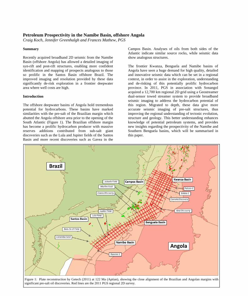
Figure 1: Plate reconstruction by Getech (2011) at 122 Ma (Aptian), showing the close alignment of the Brazilian and Angolan margins with significant pre-salt oil discoveries. Red lines are the 2011 PGS regional 2D survey.
DOI http://dx.doi.org/10.1190/segam2013-1058.1© 2013 SEGSEG Houston 2013 Annual Meeting Page 1284
Dow
nloa
ded
09/0
3/13
to 2
10.8
7.52
.22.
Red
istr
ibut
ion
subj
ect t
o SE
G li
cens
e or
cop
yrig
ht; s
ee T
erm
s of
Use
at h
ttp://
libra
ry.s
eg.o
rg/
Petroleum Prospectivity in the Namibe Basin, offshore Angola
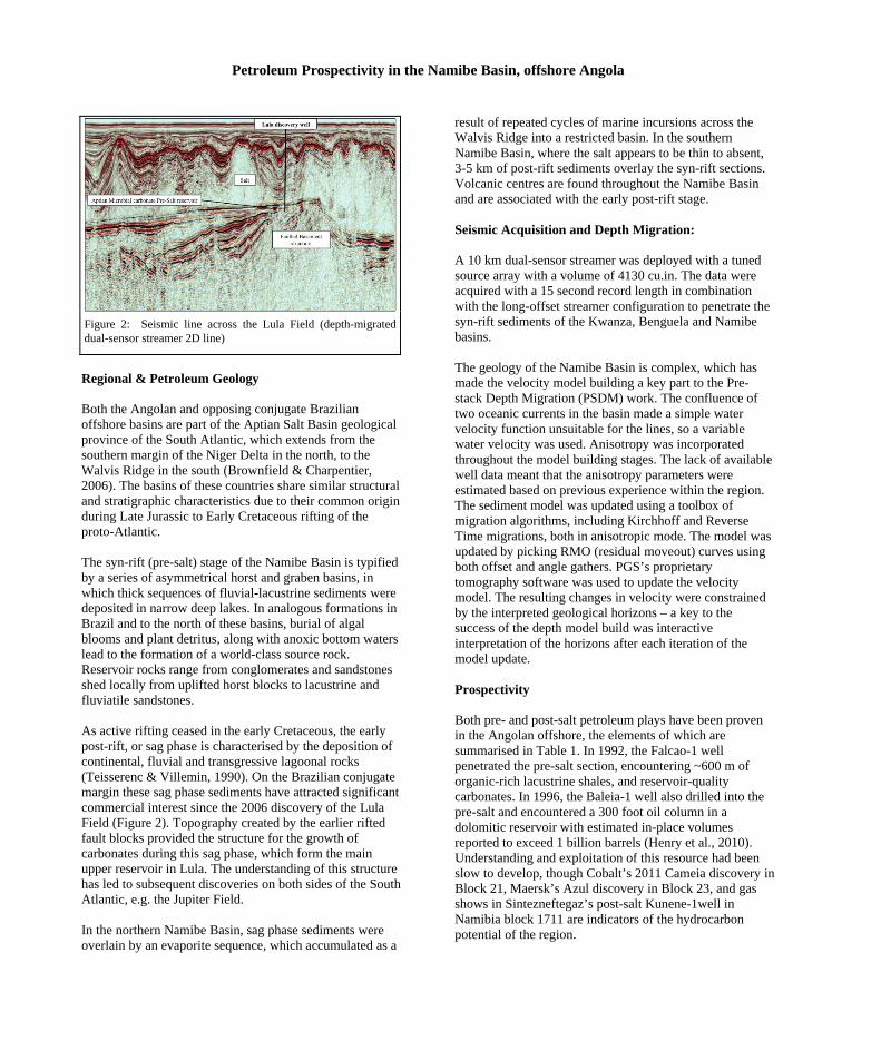
Regional & Petroleum Geology Both the Angolan and opposing conjugate Brazilian offshore basins are part of the Aptian Salt Basin geological province of the South Atlantic, which extends from the southern margin of the Niger Delta in the north, to the Walvis Ridge in the south (Brownfield & Charpentier, 2006). The basins of these countries share similar structural and stratigraphic characteristics due to their common origin during Late Jurassic to Early Cretaceous rifting of the proto-Atlantic. The syn-rift (pre-salt) stage of the Namibe Basin is typified by a series of asymmetrical horst and graben basins, in which thick sequences of fluvial-lacustrine sediments were deposited in narrow deep lakes. In analogous formations in Brazil and to the north of these basins, burial of algal blooms and plant detritus, along with anoxic bottom waters lead to the formation of a world-class source rock. Reservoir rocks range from conglomerates and sandstones shed locally from uplifted horst blocks to lacustrine and fluviatile sandstones. As active rifting ceased in the early Cretaceous, the early post-rift, or sag phase is characterised by the deposition of continental, fluvial and transgressive lagoonal rocks (Teisserenc & Villemin, 1990). On the Brazilian conjugate margin these sag phase sediments have attracted significant commercial interest since the 2006 discovery of the Lula Field (Figure 2). Topography created by the earlier rifted fault blocks provided the structure for the growth of carbonates during this sag phase, which form the main upper reservoir in Lula. The understanding of this structure has led to subsequent discoveries on both sides of the South Atlantic, e.g. the Jupiter Field. In the northern Namibe Basin, sag phase sediments were overlain by an evaporite sequence, which accumulated as a
result of repeated cycles of marine incursions across the Walvis Ridge into a restricted basin. In the southern Namibe Basin, where the salt appears to be thin to absent, 3-5 km of post-rift sediments overlay the syn-rift sections. Volcanic centres are found throughout the Namibe Basin and are associated with the early post-rift stage.
Figure 2: Seismic line across the Lula Field (depth-migrated dual-sensor streamer 2D line)
Seismic Acquisition and Depth Migration: A 10 km dual-sensor streamer was deployed with a tuned source array with a volume of 4130 cu.in. The data were acquired with a 15 second record length in combination with the long-offset streamer configuration to penetrate the syn-rift sediments of the Kwanza, Benguela and Namibe basins. The geology of the Namibe Basin is complex, which has made the velocity model building a key part to the Pre-stack Depth Migration (PSDM) work. The confluence of two oceanic currents in the basin made a simple water velocity function unsuitable for the lines, so a variable water velocity was used. Anisotropy was incorporated throughout the model building stages. The lack of available well data meant that the anisotropy parameters were estimated based on previous experience within the region. The sediment model was updated using a toolbox of migration algorithms, including Kirchhoff and Reverse Time migrations, both in anisotropic mode. The model was updated by picking RMO (residual moveout) curves using both offset and angle gathers. PGS’s proprietary tomography software was used to update the velocity model. The resulting changes in velocity were constrained by the interpreted geological horizons – a key to the success of the depth model build was interactive interpretation of the horizons after each iteration of the model update. Prospectivity Both pre- and post-salt petroleum plays have been proven in the Angolan offshore, the elements of which are summarised in Table 1. In 1992, the Falcao-1 well penetrated the pre-salt section, encountering ~600 m of organic-rich lacustrine shales, and reservoir-quality carbonates. In 1996, the Baleia-1 well also drilled into the pre-salt and encountered a 300 foot oil column in a dolomitic reservoir with estimated in-place volumes reported to exceed 1 billion barrels (Henry et al., 2010). Understanding and exploitation of this resource had been slow to develop, though Cobalt’s 2011 Cameia discovery in Block 21, Maersk’s Azul discovery in Block 23, and gas shows in Sintezneftegaz’s post-salt Kunene-1well in Namibia block 1711 are indicators of the hydrocarbon potential of the region.
DOI http://dx.doi.org/10.1190/segam2013-1058.1© 2013 SEGSEG Houston 2013 Annual Meeting Page 1285
Dow
nloa
ded
09/0
3/13
to 2
10.8
7.52
.22.
Red
istr
ibut
ion
subj
ect t
o SE
G li
cens
e or
cop
yrig
ht; s
ee T
erm
s of
Use
at h
ttp://
libra
ry.s
eg.o
rg/
Petroleum Prospectivity in the Namibe Basin, offshore Angola
Source Syn-rift lacustrine and shallow marine shales, early post-rift deep marine shales
Reservoir Syn-rift continental and shallow marine sands, sag phase carbonate banks, post rift deep marine sands
Seal Syn-rift salt in the Benguela and northern Namibe, deep marine shales across the area
Trap Multiple salt related traps, pinch outs on volcanos and basement highs, channels and fans
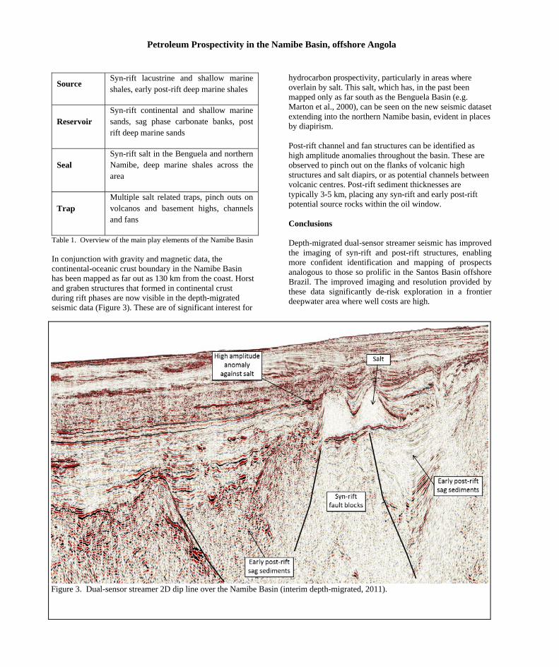
Table 1. Overview of the main play elements of the Namibe Basin In conjunction with gravity and magnetic data, the continental-oceanic crust boundary in the Namibe Basin has been mapped as far out as 130 km from the coast. Horst and graben structures that formed in continental crust during rift phases are now visible in the depth-migrated seismic data (Figure 3). These are of significant interest for
hydrocarbon prospectivity, particularly in areas where overlain by salt. This salt, which has, in the past been mapped only as far south as the Benguela Basin (e.g. Marton et al., 2000), can be seen on the new seismic dataset extending into the northern Namibe basin, evident in places by diapirism. Post-rift channel and fan structures can be identified as high amplitude anomalies throughout the basin. These are observed to pinch out on the flanks of volcanic high structures and salt diapirs, or as potential channels between volcanic centres. Post-rift sediment thicknesses are typically 3-5 km, placing any syn-rift and early post-rift potential source rocks within the oil window. Conclusions Depth-migrated dual-sensor streamer seismic has improved the imaging of syn-rift and post-rift structures, enabling more confident identification and mapping of prospects analogous to those so prolific in the Santos Basin offshore Brazil. The improved imaging and resolution provided by these data significantly de-risk exploration in a frontier deepwater area where well costs are high.
Figure 3. Dual-sensor streamer 2D dip line over the Namibe Basin (interim depth-migrated, 2011).
DOI http://dx.doi.org/10.1190/segam2013-1058.1© 2013 SEGSEG Houston 2013 Annual Meeting Page 1286
Dow
nloa
ded
09/0
3/13
to 2
10.8
7.52
.22.
Red
istr
ibut
ion
subj
ect t
o SE
G li
cens
e or
cop
yrig
ht; s
ee T
erm
s of
Use
at h
ttp://
libra
ry.s
eg.o
rg/
http://dx.doi.org/10.1190/segam2013-1058.1 EDITED REFERENCES Note: This reference list is a copy-edited version of the reference list submitted by the author. Reference lists for the 2013 SEG Technical Program Expanded Abstracts have been copy edited so that references provided with the online metadata for each paper will achieve a high degree of linking to cited sources that appear on the Web. REFERENCES
Brownfield, M. E., and R. R. Charpentier, 2006. Geology and total petroleum systems of the West-Central Coastal Province (7203): U. S. Geological Survey Bulletin , 2207-B.
Henry, S. G., Sebastio , L., Kumar, N., Sebastio, A., and P. Venkatramen, 2010, Tupi’s Conjugate: New presalt plays in the Angolan offshore: AAPG Search and Discovery Article, #90104.
Marton, L. G., G. C. Tari, and C. Y. Lehmann, 2000, Evolution of the Angolan passive margin , West Africa, with emphasis on postsalt structural styles: Geophysical Monograph, 115, 129–149.
Teisserenc, P., and J. Villemin, 1990, Sedimentary basin of Gabon — Geology and oil systems, in J. D. Edwards, and P. A. Santogrossi, eds., Divergent/passive margin basins: AAPG Memoir 48, 117–199.
DOI http://dx.doi.org/10.1190/segam2013-1058.1© 2013 SEGSEG Houston 2013 Annual Meeting Page 1287
Dow
nloa
ded
09/0
3/13
to 2
10.8
7.52
.22.
Red
istr
ibut
ion
subj
ect t
o SE
G li
cens
e or
cop
yrig
ht; s
ee T
erm
s of
Use
at h
ttp://
libra
ry.s
eg.o
rg/