Petroleum Geology, Resources—Middle Caspian Basin - USGS
42
Petroleum Geology and Resources of the Middle Caspian Basin, Former Soviet Union By Gregory F. Ulmishek U.S. Geological Survey Bulletin 2201–A U.S. Department of the Interior U.S. Geological Survey
Transcript of Petroleum Geology, Resources—Middle Caspian Basin - USGS
Petroleum Geology and Resources of the Middle Caspian Basin, Former Soviet Union
By
Gregory F. Ulmishek
U.S.
Geological Survey
Bulletin 2201–A
U.S. Department of the InteriorU.S. Geological Survey

U.S. Department of the Interior
Gale A. Norton, Secretary
U.S. Geological Survey
Charles G. Groat, Director
This publication is only available online at:
http://geology.cr.usgs.gov/pub/bulletins/b2201–a
Any use of trade, product, or firm names in this publicationis for descriptive purposes only and does not imply endorsement by the U.S. Government
Manuscript approved for publication March 23, 2001Published in the Central Region, Denver, ColoradoGraphics by Susan WaldenPhotocomposition by Norma J. MaesEdited by L.M. Carter
Version 1.0, 2001
III
Contents
Foreword................................................................................................................................................ 1Abstract ................................................................................................................................................. 1Introduction........................................................................................................................................... 3Province Overview .............................................................................................................................. 3 Province Location and Boundaries ........................................................................................... 3 Tectono-Stratigraphic Sequences ............................................................................................ 3 Structure ........................................................................................................................................ 5 Petroleum Systems....................................................................................................................... 5South Mangyshlak Total Petroleum System (110902), Middle Caspian Basin, Kazakhstan............................................................................................................................... 7 Introduction ................................................................................................................................... 7 Discovery History.......................................................................................................................... 7 Petroleum Occurrence ................................................................................................................ 7 Stratigraphic Section ................................................................................................................... 9 Source Rocks ................................................................................................................................ 12 Reservoir Rocks............................................................................................................................ 13 Seal Rocks ..................................................................................................................................... 13 Traps ............................................................................................................................................... 13 Assessment Units......................................................................................................................... 15 Assessment Unit 11090201, South Mangyshlak (Entire) .................................................. 15Terek-Caspian Total Petroleum System (110901), Middle Caspian Basin, Russia .................... 15 Introduction.................................................................................................................................... 15 Discovery History .......................................................................................................................... 15 Petroleum Occurrence................................................................................................................. 16 Stratigraphic Section.................................................................................................................... 18 Source Rocks................................................................................................................................. 18 Reservoir Rocks............................................................................................................................. 22 Seal Rocks...................................................................................................................................... 22 Traps................................................................................................................................................ 22 Assessment Units.......................................................................................................................... 23 Assessment Unit 11090101, Foldbelt-Foothills ................................................................... 23 Assessment Unit 11090103, Foreland Slope and Foredeep ............................................. 23 Assessment Unit 11090102, Terek-Sunzha Subsalt Jurassic.......................................... 23Stavropol-Prikumsk Total Petroleum System (110903), Middle Caspian Basin, Russia ........... 25 Introduction.................................................................................................................................... 25 Discovery History .......................................................................................................................... 27 Petroleum Occurrence................................................................................................................. 27 Stratigraphic Section.................................................................................................................... 30 Source Rocks................................................................................................................................. 30 Reservoir Rocks. ........................................................................................................................... 33 Seal Rocks. . ................................................................................................................................... 35 Traps................................................................................................................................................ 35Assessment Units................................................................................................................................. 35 Assessment Unit 11090302, Onshore Stavropol-Prikumsk ............................................. 35 Assessment Unit 11090301, Offshore Prikumsk Zone....................................................... 36 Assessment Unit 11090303, Central Caspian Offshore..................................................... 36References Cited.................................................................................................................................. 36
IV
Figures
1. Map showing petroleum systems and assessment units, Middle Caspian basin, Province 1109 ............................................................................................................................... 2 2. Generalized map showing main structural units of Middle Caspian basin........................ 4 3. Cross section through Middle Caspian basin ......................................................................... 6 4. Generalized map showing structural units of South Mangyshlak petroleum system...... 8 5. Sketch map showing Triassic rift systems of South Mangyshlak ....................................... 9 6. Cross section (southwest-northeast) through South Mangyshlak petroleum system .... 10 7. Cross section (south-north) through South Mangyshlak petroleum system..................... 11 8. South Mangyshlak petroleum system events chart .............................................................. 14 9. Structural map of eastern North Caucasus region................................................................ 1610. Cross sections through Terek-Sunzha and Dagestan thrust belts ...................................... 1711. Columnar stratigraphic section of Mesozoic-Tertiary rocks of Terek-Caspian petroleum system......................................................................................................................... 1912. Maps showing maturity zones in stratigraphic units of eastern North Caucasus region ............................................................................................................................................. 2013. Terek-Caspian petroleum system events chart...................................................................... 2114. Columnar stratigraphic section of Mesozoic-Tertiary rocks of Stavropol-Prikumsk petroleum system......................................................................................................................... 2615. Structural map of Triassic taphrogenic sequence of eastern North Caucasus region ... 2816. Cross section through Stavropol-Prikumsk petroleum system............................................ 2917. Diagram showing maturation model for Kochubey 2 well .................................................... 3118. Diagram showing maturation model for Gorokhov 9 well..................................................... 3219. Stavropol-Prikumsk petroleum system events chart ............................................................. 34
Tables
1. Middle Caspian basin, Province 1109— Assessment results summary – allocated resources .................................................................................................................................. 24

1
Foreword
This report was prepared as part of the World Energy Project of the U.S. Geological Survey. In the project, the world was divided into 8 regions and 937 geologic provinces. The provinces have been ranked according to the discovered oil and gas volumes within each (U.S. Geological Survey World Energy Assessment Team, 2000). Then, 76 “priority” provinces (exclusive of the U.S. and chosen for their high ranking) and 26 “boutique” provinces (exclusive of the U.S. and chosen for their anticipated petroleum richness or special regional economic importance) were selected for appraisal of oil and gas resources. The petroleum geology of these priority and boutique provinces is described in this series of reports.
The purpose of this effort is to aid in assessing the quanti-ties of oil, gas, and natural gas liquids that have the potential to be added to reserves within the next 30 years. These volumes either reside in undiscovered fields whose sizes exceed the stated minimum-field-size cutoff value for the assessment unit (vari-able, but must be at least 1 million barrels of oil equivalent) or occur as reserve growth of fields already discovered.
The petroleum system constitutes the basic geologic unit of the oil and gas assessment. The total petroleum system includes all genetically related petroleum found in shows and accumula-tions (discovered and undiscovered) that has been generated by a pod or by closely related pods of mature source rock. This petro-leum exists within a limited mappable geologic space, together with the essential mappable geologic elements (source, reservoir, and seal) that control the fundamental processes of generation, expulsion, migration, entrapment, and preservation of petroleum.
An assessment unit is a mappable part of a total petroleum system in which discovered and undiscovered fields constitute a single relatively homogeneous population such that the chosen methodology of resource assessment based on estimation of the number and sizes of undiscovered fields is applicable. A total petroleum system might equate to a single assessment unit. If necessary, a total petroleum system may be subdivided into two or more assessment units such that each assessment unit is suffi-ciently homogeneous in terms of geology, exploration consider-ations, and risk to assess individually.
A numeric code identifies each region, province, total petroleum system, and assessment unit; these codes are uniform throughout the project and will identify the same item in any of the publications. The code is as follows:
Example
Region, single digit
3
Province, three digits to the right of region code 3162
Total petroleum system, two digits to the right of province code 316205Assessment unit, two digits to the right of petroleum system code
31620504The codes for the regions and provinces are listed in
U.S. Geological Survey World Energy Assessment Team (2000).
Oil and gas reserves quoted in this report are derived from Petroleum Exploration and Production database (Petroconsult-ants, 1996) and other area reports from Petroconsultants, Inc., unless otherwise noted.
A map, figure 1 of this report, shows boundaries of the total petroleum systems, assessment units, and pods of active source rocks; it was compiled using geographic information system (GIS) software. Political boundaries and cartographic representations were taken, with permission, from Environmen-tal Systems Research Institute’s ArcWorld 1:3 million digital coverage (1992), have no political significance, and are dis-played for general reference only. Oil and gas field center-points, shown on this map, are reproduced, with permission, from Petroconsultants (1996).
Abstract
The Middle Caspian basin occupies a large area between the Great Caucasus foldbelt and the southern edge of the Pre-cambrian Russian craton. The basin also includes the central part of the Caspian Sea and the South Mangyshlak subbasin east of the sea. The basin was formed on the Hercynian accreted terrane during Late Permian–Triassic through Quaternary time. Struc-turally, the basin consists of the fold-and-thrust zone of the northern Caucasus foothills, the foredeep and foreland slope, the Stavropol-Prikumsk uplift and East Manych trough to the north of the slope, and the South Mangyshlak subbasin and slope of the Karabogaz arch east of the Caspian Sea. All these major structures extend offshore.
Four total petroleum systems (TPS) have been identified in the basin. The South Mangyshlak TPS contains more than 40 discovered fields. The principal reserves are in Lower–Middle Jurassic sandstone reservoirs in structural traps. Source rocks are poorly known, but geologic data indicate that they are in the Tri-assic taphrogenic sequence. Migration of oil and gas signifi-cantly postdated maturation of source rocks and was related to faulting and fracturing during middle Miocene to present time. A single assessment unit covers the entire TPS. Largest undiscov-ered resources of this assessment unit are expected in the largely undrilled offshore portion of the TPS, especially on the western plunge of the Mangyshlak meganticline.
Petroleum Geology and Resources of the Middle Caspian Basin, Former Soviet Union
By
Gregory F. Ulmishek

2 Petroleum Geology, Resources—Middle Caspian Basin, Former Soviet Union
Donbas Foldbelt
North Caspian Basin
Great C
aucasus Foldbelt
Mangyshlak-Ustyurt Foldbelt
ASSESSMENT DATA
Assessment units boundary and name
11090101
11090103
11090102
11090201
11090301
11090302
11090303
Total petroleum system boundary and name
Terek-Caspian
Stavropol-Prikumsk
South M
angyshlak
Shakpakhty
J
J
J
J Pod of active source rocks boundary— Ticks indicate side of their presence; �-Triassic, J-Jurassic
EXPLANATION
HydrographyShorelineGeologic province name and boundary
Gas field centerpointOil field centerpoint
Projection: Equidistant Conic. Central meridian: 100. Standard Parallel: 58 30
South Caspian Basin
J
J
North Ustyurt Basin
Karabogaz-Karakum High
Kura Basin
Middle Caspian Basin
Figure 1. Map showing petroleum systems and assessment units of Middle Caspian basin, Province 1109.
TRTR
TR
TRTR
TR
40° E
45° N 45° E
50° N
50° E
45° N
55° E
55° E
40° N
40° N
50° E
45° E
Country boundary
Kazakhstan
Russia
150 KILOMETERS0
N
Introduction 3
The Terek-Caspian TPS occupies the fold-and-thrust belt, foredeep, and adjoining foreland slope. About 50 hydrocarbon fields, primarily oil, have been discovered in the TPS. Almost all hydrocarbon reserves are in faulted structural traps related to thrusting of the foldbelt, and most traps are in frontal edges of the thrust sheets. The traps are further complicated by plastic deformation of Upper Jurassic salt and Maykop series (Oli-gocene–lower Miocene) shale. Principal reservoirs are fractured Upper Cretaceous carbonates and middle Miocene sandstones. Principal source rocks are organic-rich shales in the lower part of the Maykop series. Source rocks may also be present in the Eocene, Upper Jurassic, and Middle Jurassic sections, but their contribution to discovered reserves is probably small. Three assessment units are delineated in the TPS. One of them encom-passes the thrust-and-fold belt of northern Caucasus foothills. This assessment unit contains most of the undiscovered oil resources. The second assessment unit occupies the foredeep and largely undeformed foreland slope. Undiscovered resources of this unit are relatively small and primarily related to stratigraphic traps. The third unit is identified in almost untested subsalt Juras-sic rocks occurring at great depths and is speculative. The unit may contain significant amounts of gas under the Upper Jurassic salt seal.
The Stavropol-Prikumsk TPS lies north of the Terek-Cas-pian TPS and extends offshore into the central Caspian Sea where geologic data are scarce. More than one hundred oil and gas fields have been found onshore. Offshore, only one well was recently drilled, and this well discovered a large oil and gas field. Almost the entire sedimentary section of the TPS is productive; however, the principal oil reserves are in Lower Cretaceous clas-tic reservoirs in structural traps of the Prikumsk uplift. Most original gas reserves are in Paleogene reservoirs of the Stavropol arch and these reservoirs are largely depleted. At least three source rock formations, in the Lower Triassic, Middle Jurassic, and Oligocene–lower Miocene (Maykop series), are present in the TPS. Geochemical data are inadequate to correlate oils and gases in most reservoirs with particular source rocks, and wide-spread mixing of hydrocarbons apparently took place. Three assessment units encompassing the onshore area of the TPS, the offshore continuation of the Prikumsk uplift, and the central Cas-pian area, are identified. The principal portion of undiscovered resources is assigned to the offshore Prikumsk zone where a large discovery was recently made (after this resource assess-ment had been completed).
The Shakpakhty TPS is small and located east of the South Mangyshlak subbasin. The TPS contains a single gas field, pos-sesses very low potential, and has not been assessed.
Introduction
With 14.4 billion barrels of oil equivalent (BOE) of discov-ered hydrocarbon reserves, the Middle Caspian basin is ranked 27th among 102 provinces designated for appraisal of undiscov-ered oil and gas resources by the U.S. Geological Survey (U.S. Geological Survey World Energy Assessment Team, 2000). The location and boundaries of the province are shown in figure 1. This report outlines the principal geologic features of the basin and defines its total petroleum systems (TPS) and assessment
units (AU). Definitions of the TPS and AU are given in the Fore-word of this report. The assessment technique and procedure are explained in U.S. Geological Survey World Energy Assessment Team (2000).
The first production in the basin was established as early as 1893, when a well discovered oil in shallow middle Miocene sandstones near Groznyi, Russia. However, major discoveries in the basin were made in deeper Cretaceous and Jurassic rocks in the 1950’s and 1960. Peak production was reached in 1969–1971, after which a gradual decline in production of both oil and gas began (Dikenshtein and others, 1983). Exploration in the basin has been almost entirely concentrated on land, and only a few wells have been drilled offshore. The first offshore oil and gas field (Inchkhe-more) was found in 1974 in the southeastern nearshore area, but several other prospects drilled in the 1980’s failed to discover commercial accumulations. In 2000, Russian company Lukoil announced discovery of a large (potentially more than 2 billlion BOE) oil and gas field in the north-central offshore area (Severny area) of the basin (The Wall Street Jour-nal, 2000). The basin mostly lies in Russia and Kazakhstan; a small southwestern part of the basin is in Azerbaijan.
Province Overview
Province Location and Boundaries
The Middle Caspian basin occupies the eastern North Cau-casus region, the central part of the Caspian Sea, and a system of depressions east of the sea (fig. 1). The southern basin boundary is defined by the Great Caucasus foldbelt, Karabogaz arch, and, in offshore areas, by the Apsheron sill (Apsheron-Pribalkhan zone of uplifts) separating the Middle Caspian and South Cas-pian basins (fig. 2). The northern boundary with the North Cas-pian basin extends along the Karpinsky Ridge (southeastern continuation of the Donbas foldbelt). Strongly deformed upper Paleozoic rocks of the ridge (foldbelt) are exposed on the surface in its western part and buried under Mesozoic and Tertiary rocks in the eastern part. Offshore, the boundary is defined by the southern limit of salt tectonics, and farther east it is drawn along the Mangyshlak and Central Ustyurt systems of uplifts (fig. 4). On the west, the Stavropol arch and Mineralovod high separate the Middle Caspian basin from the Azov-Kuban basin located farther west. On the Stavropol arch, the basement is overlain by Albian and younger rocks and older stratigraphic units pinch out on the slopes. Most of the basin is located in Russia (west of the Caspian Sea) and Kazakhstan (east of the sea). A small southern part of the western nearshore area is in Azerbaijan.
Tectono-Stratigraphic Sequences
Basement of the Middle Caspian basin is a Hercynian accreted terrane composed of various middle to late Paleozoic deformed rocks. The basement is overlain by the Late Permian–Triassic rift system filled with clastic, carbonate, and volcanic rocks. Various parts of this taphrogenic sequence are unconform-ably overlain by a platform sequence of Jurassic through Eocene rocks. Lower–Middle Jurassic clastics, commonly enriched by coaly organic matter, occur at the base of this sequence. The

4Petroleum
Geology, Resources—
Middle Caspian B
asin, Former Soviet U
nion
B
A
N
ApsheronSill
North ApsheronDepression
GreatCaucasus
Foldbelt
Terek - CaspianForedeep
Uplift
Chernoles
Depression
Mineralovod
High
StavropolArch
Karpinsky RidgeEast Manych Trough
Agrakhan - Gurye
vFault
Central Ustyurt
System of Uplifts
North Ustyurt Basin
Mangyshlak MeganticlineSouth Mangyshlak - Ustyurt System
ofDepressions
Central CaspianMonocline
Peschanomys
Uplift
KazakhDepression
Ka r a b o g a z
A r c h
NorthRakushechnoyeUplift
UpliftDerbent
Boundary of major tectonic unitMain faultLine of cross section in figure 3
Figure 2. Generalized map showing main structural units of Middle Caspian basin (modified from Ulmishek and Harrison, 1981).
0
0
40
20
80
40 60
KILOMETERS
MILES
Caspian
Sea
Terek River
PrikumskKu m
a
River
EXPLANATION
A B
o45 55° E50°
45° N
Province Overview 5
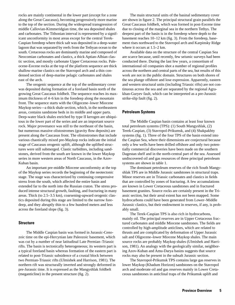
rocks are mainly continental in the lower part (except for a zone along the Great Caucasus), becoming progressively more marine to the top of the section. During the widespread transgression of middle Callovian-Kimmeridgian time, the sea deposited shales and carbonates. The Tithonian interval is represented by a signif-icant unconformity in most areas except for the central Terek-Caspian foredeep where thick salt was deposited in a deep-water lagoon that was separated by reefs from the Tethyan ocean to the south. Cretaceous rocks are dominantly marine and composed of Neocomian carbonates and clastics, a thick Aptian-Albian clas-tic section, and mostly carbonate Upper Cretaceous rocks. Pale-ocene-Eocene rocks at the top of the platform sequence are thick shallow-marine clastics on the Stavropol arch and a thin con-densed section of deep-marine pelagic carbonates and shales east of the arch.
The orogenic sequence at the top of the sedimentary cover was deposited during formation of a foreland basin north of the growing Great Caucasus foldbelt. The sequence reaches its max-imum thickness of 4–6 km in the foredeep along the mountain front. The sequence starts with the Oligocene–lower Miocene Maykop series—a thick shale section, which, in the northeastern areas, contains sandstone beds in its middle and upper parts. Deep-water black shales enriched by type II kerogen are ubiqui-tous in the lower part of the series and are an important source rock. Major provenance was still to the northeast of the basin, but numerous massive olistostromes (gravity flow deposits) are present along the Caucasus front. The olistostromes that include various chaotically mixed pre-Maykop rocks indicate the initial stage of Caucasus orogenic uplift, although the uplifted struc-tures were still submerged. Clastic turbidites, including sand-stones, derived from the south are known in the lower Maykop series in more western areas of North Caucasus, in the Azov-Kuban basin.
An important pre-middle Miocene unconformity at the top of the Maykop series records the beginning of the neotectonic stage. The stage was characterized by continuing compressive stress from the south, which affected the entire basin and extended far to the north into the Russian craton. The stress pro-duced intense structural growth, faulting, and fracturing in many areas. Thick (to 2.5–3.5 km), coarsening-upward orogenic clas-tics deposited during this stage are limited to the narrow fore-deep, and they abruptly thin to a few hundred meters and less across the foreland slope (fig. 3).
Structure
The Middle Caspian basin was formed in Jurassic-Ceno-zoic time on the epi-Hercynian late Paleozoic basement, which was cut by a number of near latitudinal Late Permian–Triassic rifts. The basin is tectonically heterogeneous; its western part is a typical foreland basin whereas formation of the eastern part is related to post-Triassic subsidence of a crustal block between two Permian-Triassic rifts (Ulmishek and Harrison, 1981). The northern rift was structurally inverted and strongly deformed in pre-Jurassic time. It is expressed as the Mangyshlak foldbelt (meganticline) in the present structure (fig. 2).
The main structural units of the basinal sedimentary cover are shown in figure 2. The principal structural grain parallels the Great Caucasus foldbelt, which was formed in post-Eocene time due to closing of the marginal sea in the northern Tethys. The deepest part of the basin is in the foredeep where depth to the basement reaches 10–12 km (fig. 3). From the foredeep, base-ment rises northward to the Stavropol arch and Karpinsky Ridge where it occurs at 1.5–2 km.
Available data on the structure of the central Caspian Sea are scarce because, until recently, few seismic surveys had been conducted there. During the last few years, a consortium of international oil companies shot a number of regional profiles across the northern and central parts of the sea, but results of this work are not in the public domain. Structures on both shores of the sea plunge offshore and lose expression. Apparently, eastern and western structural units (including Triassic rifts) are not con-tinuous across the sea and are separated by the regional Agra-khan-Guryev fault, which can be interpreted as a pre-Jurassic strike-slip fault (fig. 2).
Petroleum Systems
The Middle Caspian basin contains at least four known total petroleum systems (TPS): (1) South Mangyshlak, (2) Terek-Caspian, (3) Stavropol-Prikumsk, and (4) Shakpakhty systems (fig. 1). Three of the four TPS of the basin extend into the Caspian Sea, where their dimensions are conjectural because only a few wells have been drilled offshore and only two poten-tially commercial discoveries have been made on the southern Dagestan shelf and in the north-central part of the sea. Assessed undiscovered oil and gas resources of three principal petroleum systems are shown in table 1.
The dominant petroleum reserves of the rich South Mangy-shlak TPS are in Middle Jurassic sandstones in structural traps. Minor reserves are in Triassic carbonates and clastics in fields that are controlled by zones of fracturing. A few accumulations are known in Lower Cretaceous sandstones and in fractured basement granites. Source rocks are certainly present in the Tri-assic section, but their areal extent has not been mapped. Some hydrocarbons could have been generated from Lower–Middle Jurassic clastics, but their endowment in reserves, if any, is prob-ably small.
The Terek-Caspian TPS is also rich in hydrocarbons, mainly oil. The principal reserves are in Upper Cretaceous frac-tured carbonates and middle Miocene sandstones. The fields are controlled by high-amplitude anticlines, which are related to thrusts and are complicated by deformation of Upper Jurassic salt and Oligocene–lower Miocene Maykop shales. The main source rocks are probably Maykop shales (Ulmishek and Harri-son, 1981). An analogy with the geologically similar, neighbor-ing Azov-Kuban and Amu-Darya basins suggests that source rocks may also be present in the subsalt Jurassic section.
The Stavropol-Prikumsk TPS contains large gas reserves in lower Maykop (Khadum Horizon) sandstones on the Stavropol arch and moderate oil and gas reserves mainly in Lower Creta-ceous sandstones in anticlinal traps of the Prikumsk uplift and

6Petroleum
Geology, Resources—
Middle Caspian B
asin, Former Soviet U
nion
�1�1+2
�1+2
�2
�3
Km
KILOMETERS
MILES
0 10 20 30 40 50
0 10 20 30
K1
K2K1
K2
2
Figure 3. Cross section through Middle Caspian basin (modified from Dikenshtein and others, 1983). Location shown in figure 2. Although this figure shows otherwise, Terek and Sunzha anticlines are related to thrusts with decollement in Upper Jurassic evaporites. (See fig. 10.) P, Permian; �, Triassic; J, Jurassic; K, Cretaceous; T, Tertiary; Q, Quaternary. Subscripts 1, 2, and 3 denote lower, middle, and upper respectively.
T2-QT2-Q
J3J3
J1+2
J1+2
J1-2
J1-2
J1+2
K2K1 K1
T1 T1
T1T1
T2
P +
P +
K1
2 1
S.L. 0 1
2 3
4
5
6 7
8 9
10
11Km
FaultOil and gas pools
NSTerek-Caspian Foredeep Nogay Monocline Prikumsk Uplift East Manych Trough Karpinsky Ridge
Sunzha RidgeKarabulak-Achaluki
Field
Terek RidgeAli-Yurt Field
Mekteb Field
YuzhnoyeField
Zimnyaya StavkaField
KomsomolskoyeField
A B
0 S.L.
1
23
4
5
6
7
8
9
1011
Basement
EXPLANATION
�
�1

South Mangyshlak Total Petroleum System (110902), Middle Caspian Basin, Kazakhstan 7
adjacent structures. Minor reserves have been discovered in Jurassic clastics, Lower Triassic carbonates, and in self-sourced fractured shale reservoirs in the lower part of the Maykop series. Principal source rocks are difficult to identify. Probably they are Bajocian marine shales moderately rich in organic matter. Source rocks are also present in Lower Triassic and lower May-kop sections. When more geochemical data are available, two or three overlapping petroleum systems can probably be identified in the sedimentary section.
The Shakpakhty TPS is identified by the Shakpakhty gas field where three gas pools are reservoired in Middle Jurassic clastic rocks. Source rocks for the gas are unknown. A number of other structural prospects have been drilled in the area, but no commercial accumulations or even significant shows have been found. The petroleum potential of the system is low, and it is not assessed or further described in this report.
South Mangyshlak Total Petroleum System (110902), Middle Caspian Basin, Kazakhstan
Introduction
The South Mangyshlak total petroleum system (TPS) is located in the eastern part of the Middle Caspian basin, east of the Caspian Sea (fig. 1). On the north and northeast, the system is bounded by the Mangyshlak foldbelt, which is a structurally inverted and deformed axial zone of the Triassic rift. On the south, the TPS borders the Karabogaz arch where thin Creta-ceous and Tertiary rocks overlie the basement. To the west, the TPS extends into the central Caspian Sea where its dimension is unknown. Possibly, it extends to the Agrakhan-Guryev strike-slip(?) fault separating structures of the western and eastern Caspian Sea (fig. 2).
Proved hydrocarbon reserves of the system exceed 6 bil-lion barrels of oil equivalent (BOE), most of which (84 percent) is oil. Most hydrocarbons are in Middle Jurassic clastic reser-voirs on the Zhetybay step (structural terrace) south of the Mangyshlak foldbelt (fig. 4). Fields in the area include two giant (Uzen and Zhetybay) and a number of medium and small fields. Several small accumulations have been discovered in carbonate and clastic Triassic reservoirs on the Zhetybay step, on the slope of the Karabogaz arch, and on the Peschanomys uplift. Despite significant exploration efforts, no fields have been found in the deep South Mangyshlak (Zhazgurly and Segendyk) depressions. Source rocks have not been geochemically identified; however, spatial distribution of hydrocarbon accumulations indicates that major source rocks occur in the Lower–Middle Triassic section. Lower–Middle Jurassic coaly, continental to marine rocks could have been a secondary source, but probably of limited impor-tance.
Discovery History
Shallow core drilling for delineation of surface structures on the Zhetybay step started in 1957. In 1960, one of the wells penetrated a shallow gas pool in Cretaceous rocks of the Uzen
field. Deep drilling began shortly thereafter, and in 1961 two giant fields, Uzen and Zhetybay, in Lower–Middle Jurassic clas-tic rocks, were discovered. Exploration in the following years was targeted at this section, and a series of smaller discoveries were made. By the end of the 1960’s, structural prospects of the Zhetybay step had been largely exhausted, and attempts to explore structures in the South Mangyshlak depressions had failed. The first gas and condensate flow from the Triassic sec-tion was obtained in 1972 in the South Zhetybay field, opening a new play in the petroleum system. Exploration efforts then were extended to the Peschanomys uplift and the slope of the Karabogaz arch where a number of medium and small size fields in Triassic rocks were found. Several wells were also drilled offshore, but only noncommercial hydrocarbon flows were obtained.
Petroleum Occurrence
Most oil and gas fields of the system and the great majority of discovered reserves are found on the Zhetybay step, which is a gently southward dipping structural terrace between the Beke-bashkuduk anticline of the Mangyshlak foldbelt and the deep depressions farther south (fig. 4). Except for a few small gas accumulations in Cretaceous rocks of the Uzen field and several oil and gas condensate accumulations in Triassic rocks, all pools occur in the Lower–Middle Jurassic clastics below the Upper Jurassic regional seal. On the Bekebashkuduk anticline, deformed Triassic rocks are overlain by a thin Jurassic-Creta-ceous section, and the regional seal is truncated by a pre-Creta-ceous unconformity. Several heavy oil accumulations, including the very large Karasyaz-Taspas pool at depths of 400–500 m, are known in Lower Cretaceous rocks. These rocks also contain a few pools on the western plunge of the Bekebashkuduk and more northern anticlines of the Mangyshlak foldbelt.
Several oil and gas condensate fields of small to medium size have been discovered south of the South Mangyshlak depressions. The fields are located on the Peschanomys uplift and on the northern slope of the Karabogaz arch, above or near the Kara-Audan buried rift of Late Permian(?)-Triassic age (fig. 5; Murzagaliev, 1996). Most reserves of these fields are in the Middle Triassic carbonate formation although a few pools are present in other parts of the Mesozoic section. A medium-size oil pool has been discovered in a fractured granite batholith of the basement in the Oymasha field.
Few wells have been drilled offshore, but all failed to make commercial discoveries. Only one well in the Rakushechnaya-more prospect on the offshore extension of the Peschanomys uplift (fig. 2) recorded a significant gas condensate show from Triassic rocks, but apparently the show was considered noncom-mercial. Despite significant exploration efforts, no discoveries have been made in either the Segendyk or Zhazgurly depres-sions (fig. 4), although structural traps, Lower–Middle Jurassic reservoir rocks, and a thick Upper Jurassic seal are present there.
All oils of the petroleum system have common chemical characteristics. They are of medium gravity (31
°
–38
°
API in most pools) and have very high paraffin (to 30 percent) and resin (10–20 percent) contents and low sulfur content (0.1–0.25

8 Petroleum Geology, Resources—Middle Caspian Basin, Former Soviet Union
Seg
endy
k
Upl
ift
Upl
ifts
I
II
I
II
N
Dep
ress
ion
Zhet
ybay
Ste
p
Pes
chan
omys
Zhaz
gurly
Dep
ress
ion
Kaza
kh
Dep
ress
ion
So
ut h
Ma
ng
ys
hl a
k
De
pre
ss
i on
s
Tumgachi Ant
icline
Kols
ayDep
ress
ion
Uplift
Kara
shek
Cen
tral U
styu
rtS
yste
mof
Muz
bel U
plift
Tyub
-Kar
agan
Ant
iclin
e
Ka
rab
og
az
Ar c
h
Nor
th U
styu
rt B
asin
Be
keb
as
hk
ud
uk
An
t ic
l in
e
Kar
agi
Saddle
Kar
atau
Ant
iclin
e
Ma
ng
ys
hl a
kS
ys
t em
of
Upl
i ft s
Ch
ak
yr g
an
Tr o
ug
h
C a s p i a n S e a
020
4060
KILO
MET
ERS
Bou
ndar
y of
maj
or t
ecto
nic
unit
Bou
ndar
y of
oth
er s
truc
ture
s
Figu
re 4
. G
ener
alize
d m
ap s
how
ing
stru
ctur
al u
nits
of S
outh
Man
gysh
lak
petro
leum
sys
tem
(mod
ified
from
Kry
lov,
197
1). C
ross
sec
tions
are
sho
wn
in fi
gure
s 6
and
7.
Lin
e of
cro
ss s
ection
, figu
res
6 a
nd 7
EXPL
AN
ATIO
N
50°
55° E
percent). No significant changes in chemical properties of oils from different depths are noticeable. None of the South Mangy-shlak oils have been studied by modern geochemical methods. However, group compositions of Jurassic and Triassic oils are
similar, and both oil groups are highly mature and are character-ized by similar distribution of normal alkanes (Timurziev, 1986). These characteristics and other geologic data suggest that the oils were probably generated from the same source rock.

South Mangyshlak Total Petroleum System (110902), Middle Caspian Basin, Kazakhstan 9
CA
SP
I AN
S EA
KARABOGAZ
BAY
KARA-AUDANRIFT
CENTRALMANGYSHLAK
RIFT
TUARKYR
RIFT
Figure 5. Sketch map showing Triassic rift systems of South Mangyshlak (modified from Murzagaliev, 1996). No scale.
__ __
EXPLANATION
Outcrop of Triassic-Jurassic rocksGravity anomalyFaultInferred fault
N
Gases of the petroleum system are typical thermogenic gases. They contain 8–15 percent ethane and heavier homologues, small amounts of carbon dioxide (0.4–1.7 percent), and varying amounts of nitrogen (1–10 percent).
Stratigraphic Section
The upper Olenekian–Middle Triassic carbonate formation, which includes the main source rocks, overlies lower Olenekian
marine variegated clastics and Induan red beds, which are more than 1,500 m thick on the Zhetybay step. These rocks thin and pinch out on the Peschanomys uplift. Older, Upper Permian, gray clastic rocks are present only in the Mangyshlak and, prob-ably, in the Kara-Audan rifts. Upper Triassic marine clastics, directly overlying the upper Olenekian–Middle Triassic carbon-ate formation, are preserved chiefly in the South Mangyshlak depressions where they are up to 600 m thick. On the Zhetybay step and slopes of the Karabogaz arch, the rocks were eroded in pre-Jurassic time (figs. 6, 7).

10Petroleum
Geology, Resources—
Middle Caspian B
asin, Former Soviet U
nion
�
RIFTKmKARA-AUDAN
KARAGI SADDLEPESCHANOMYS UPLIFT ZHETYBAY STEPBEKE-BASHKUDUK ANTICLINE
Karasyaz-TaspasZhalganoy
Bekturly ZhetybayS. ZhetybayN. Rakushechnaya Rakushechnaya - more
Basement
Basement
Oil and gas pools
1
2
0
3
4
5
6
J2
P2 (?)P2 (?)
K1
2J
K2
J1
J3
SWI
NEI
T1
b.s.l.
Figure 6. Cross section through South Mangyshlak petroleum system (modified from Orudzheva and others, 1985). Location shown in figure 4. Pz, Paleozoic; P, Permian; , �, Triassic; J, Jurassic; K, Cretaceous; T, Tertiary. Subscripts 1, 2, and 3 denote lower, middle, and upper, respectively.
Fault
EXPLANATION
�1
�1
�1
�1
�2
�3
� �

South Mangyshlak Total Petroleum
System (110902), M
iddle Caspian Basin, Kazakhstan
11
II II
Fault
Oil and gas pools
Basement
Kuduk
SLOPE OF KARABOGAZ ARCH
Tamdy Bukbash Temir-BabaAksu-Kendyrli
ZHAZGURLY DEPRESSION
Kaundy Kurganbay
ZHETYBAY STEP
Tenge Uzen
N
KARA-AUDAN RIFT
0
1
2
3
4
Km b.s.l.
Basement
S
Figure 7. Cross section through South Mangyshlak petroleum system (modified from Orudzheva and others, 1985). Location shown in figure 4. P, Permian; �, Triassic; J, Jurassic; K, Cretaceous; T, Tertiary. Subscripts 1, 2, and 3 denote lower, middle, and upper, respectively.
P2
K2
K1
T1
T2
J3
J2 J1
EXPLANATION
�1
�2�2 �2
�1
�3 �1

12 Petroleum Geology, Resources—Middle Caspian Basin, Former Soviet Union
The Lower–Middle Jurassic (to top of the lower Callovian) section includes the principal producing pays of the petroleum system. The lower part of the section (through the Bajocian) is composed of various coal-bearing continental clastics. Marine interbeds are more common in the Bathonian. Thickness of the section reaches 1,300–1,400 m in central parts of the South Mangyshlak depressions and thins to 800–1,000 m on the Zhety-bay step. An overlying marine transgressive section of middle Callovian–Kimmeridgian age consists of shales and carbonates and is a regional seal. The section is 500–700 m thick in central areas of the South Mangyshlak depressions and thins northward and southward. The Volgian Stage is absent.
The Lower Cretaceous section is 1,100–1,200 m thick in the depressions and 700–900 m thick on the Zhetybay step. The section is composed of Valanginian-Hauterivian carbonates, Barremian continental clastics, and thick Aptian-Albian marine shales with beds of sandstone. The Upper Cretaceous is 300–600 m thick in the depressions and thins to 100–200 m toward the Mangyshlak foldbelt. It includes Cenomanian–lower Turonian marine clastics and upper Turonian–Maastrichtian carbonates. Paleocene-Eocene rocks are chiefly carbonates, 50–200 m thick, unconformably overlying Upper Cretaceous rocks. The Maykop series (Oligocene–lower Miocene) is composed of marine shales up to 800 m thick in the depressions and 100–200 m thick on the Zhetybay step and Peschanomys uplift (figs. 6, 7). Middle Miocene and younger rocks lie unconformably on various parts of the Maykop series. They are present only in the South Mangyshlak depressions and are not more than 250 m thick.
Source Rocks
Source rocks for the petroleum system have not been posi-tively identified. Two opposing points of view suggest that (1) source rocks for Triassic-reservoired oils are in the Lower–Mid-dle Triassic marine section, whereas Jurassic and Cretaceous oils were generated from largely continental Lower–Middle Jurassic rocks with mainly type III kerogen (Kabanova and Braslavskaya, 1979; Florensky and others, 1975) and (2) all oils were generated from Triassic source rocks and migrated into overlying strata (Timurziev, 1986). Although convincing geochemical data are absent, geologic considerations suggest that the principal source rocks of the petroleum system are strati-graphically confined to the upper Olenekian–Middle Triassic section composed of alternating shales, carbonates, and tuffs. Thickness of the section is about 750 m in the southern part of the Zhetybay step and 250–300 m on the Peschanomys uplift. Measured TOC contents in shales reach 9.8 percent and organic matter is dominated by type II kerogen (Shablinskaya and oth-ers, 1990). An interval of black bituminous shales (“oily shale”) is present on the Zhetybay step in the Karadzhatyk Formation of the upper Olenekian Stage (Florensky and others, 1975). The generative potential of Induan and Upper Triassic rocks is sub-stantially lower (Tverdova and others, 1982; Tverdova, 1988). Source rock quality of Lower–Middle Jurassic rocks is poor. Kerogen is dominantly of type III, and TOC content in shales commonly ranges from 0.5 to 1 percent reaching 1.5 percent only in the central part of the Segendyk depression (Polyakova, 1977).
In central areas of the South Mangyshlak depressions, Lower–Middle Jurassic rocks are thicker, buried at greater depths, and contain higher TOC. Structural traps, reservoir rocks, and seals are present; however, despite a significant amount of drilling, no discoveries have been made. Most proba-bly, the lack of discoveries is related to insufficient generative potential of these rocks. Probable Triassic source rocks have been deposited in different geologic environments. Major areas of subsidence and best conditions for source rock deposition were confined to grabens of the Mangyshlak and Kara-Audan rifts and their shoulders where deeper-water anoxic basins prob-ably existed (fig. 5). In the central zone of the former, Lower–Middle Triassic source rocks are strongly overmature and were deformed during rift inversion and folding. The source rocks were truncated by pre-Jurassic erosion in the northern part of the Zhetybay step where the giant Uzen field is located. How-ever, Lower Triassic rocks that subcrop at the pre-Jurassic unconformity in this area may belong to the upper thrust sheet and may be underlain by younger Triassic source rocks. The Lower–Middle Triassic source rocks are certainly present in the southern part of the Zhetybay step and in the Kara-Audan rift (Orudzheva and others, 1985). Areas of the present-day South Mangyshlak depressions are between the two rifts and, in Trias-sic time, probably were a shallow-water platform devoid of organic-rich rocks. Another model that seems improbable, but cannot be excluded, is that Lower–Middle Triassic source rocks do extend from the Zhetybay step into the South Mangyshlak depressions, but hydrocarbons could not migrate upward into Jurassic reservoirs because of the lack of significant faults and the presence of the Upper Triassic seal.
The preceding considerations indicate that the principal source rocks of the South Mangyshlak petroleum system are basinal facies of parts of the upper Olenekian–Middle Triassic carbonate formation, probably its upper Olenekian part (Karadzhatyk Formation). The expected main areas of source rock development are the southern zone of the Zhetybay step, possibly the Bekebashkuduk anticline, and the Kara-Audan rift (figs. 4, 5). All discovered fields of the TPS are found either in these areas or updip in close proximity to them. The generative potential of Lower–Middle Jurassic rocks that contain most of petroleum reserves is low. Possibly, these rocks generated some gas, which is mixed with hydrocarbons migrated from the prin-cipal source.
Time of the beginning of oil generation by Triassic source rocks is uncertain. The present-day geothermal gradient varies from 38
°
to 41
°
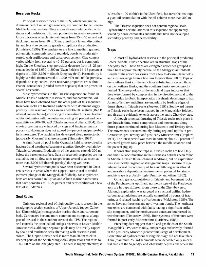
C/km in most wells; however, it was probably substantially higher during the Triassic rifting event. Following this event, large volumes of Triassic rocks were denuded in pre-Jurassic time. A leap in vitrinite reflectance values between uppermost Triassic and basal Jurassic rocks has been reported in some wells (Bobylev and Grechishnikov, 1983). These uncer-tainties hamper modeling of oil generation history. Oil genera-tion probably started during deposition of thick Cretaceous rocks and continued through deposition of the Oligocene–lower Miocene Maykop series (fig. 8). Pre-middle Miocene uplift resulted in deep and extensive erosion of older sediments, and little or no hydrocarbon generation could have occurred after-wards.
South Mangyshlak Total Petroleum System (110902), Middle Caspian Basin, Kazakhstan 13
Reservoir Rocks
Principal reservoir rocks of the TPS, which contain the dominant part of oil and gas reserves, are confined to the Lower–Middle Jurassic section. They are sandstones interbedded with shales and mudstones. Thirteen productive intervals are present. Gross thickness of each interval ranges from 35 to 65 m, and net thickness ranges from 10 to 30 m. Significant lateral discontinu-ity and lens-like geometry greatly complicate the production (Ulmishek, 1990). The sandstones are fine to medium grained, polymictic, commonly poorly rounded, poorly to moderately sorted, with argillaceous and calcareous cement. Clay content varies widely from several to 40–50 percent, but is commonly high. On the Zhetybay step, porosities decrease from 18–23 per-cent at depths of 1,050–1,300 m (Uzen field) to 14–18 percent at depths of 1,950–2,650 m (South Zhetybay field). Permeability is highly variable (from several to 1,200 mD) and, unlike porosity, depends on clay content. Best reservoir properties are within channel sandstones (braided-stream deposits) that are present in several reservoirs.
Most hydrocarbons in the Triassic sequence are found in Middle Triassic carbonate reservoirs, and noncommercial oil flows have been obtained from the other parts of this sequence. Reservoir rocks are fractured carbonates with dominant vuggy porosity. Best reservoir rocks are in a bed 30–180 m thick (Bed B of local nomenclature), consisting of alternating tuffs and leached oolitic dolomites with porosities exceeding 20 percent and per-meabilities to 200–300 mD (Cherbyanova and others, 1984). Res-ervoir properties are enhanced by vugs and fractures; matrix porosity of dolomites does not exceed 3–4 percent and permeabil-ity is near zero. The leaching has developed along neotectonic (post-early Miocene) fracture systems (Timurziev, 1984).
A significant oil pool in the Oymasha field is reservoired in fractured and weathered basement granites directly overlain by Triassic carbonates. Productivity of the granites extends 300 m below the basement surface. Data on reservoir properties are not available, but oil flow rates ranged from several to as much as more than 2,000 b/d (barrels per day) during well tests.
Several hydrocarbon pools have been discovered in Creta-ceous rocks in areas where the Upper Jurassic seal is eroded (western plunge of the Mangyshlak foldbelt). Most hydrocar-bons are reservoired in Aptian and Albian marine sandstones that have porosities of 16–21 percent and permeabilities of a few tens of millidarcies.
Seal Rocks
Only one regional seal of high quality that is present in the stratigraphic section consists of Upper Jurassic (upper Callov-ian–Kimmeridgian) transgressive marine shale and carbonate beds. Carbonates become more common and compose a large part of the seal in the southern areas of the TPS. The regional seal controls the principal oil and gas reserves in Lower–Middle Jurassic rocks, although separate pools may be directly capped by shale and mudstone beds alternating with reservoir sand-stones. The Upper Jurassic seal is more than 500 m thick in deepest parts of the South Mangyshlak depressions but thins to 100–300 m on the Zhetybay step. The seal is highly effective; it
is less than 100 m thick in the Uzen field, but nevertheless traps a giant oil accumulation with the oil column more than 300 m high.
The Triassic sequence does not contain regional seals. Hydrocarbon accumulations in this sequence are apparently sealed by dense carbonates and tuffs that have not developed secondary porosity and permeability.
Traps
Almost all hydrocarbon reserves in the principal producing Lower–Middle Jurassic section are in structural traps of the Zhetybay step. These traps are elongated anticlines grouped in three lines approximately parallel to the Mangyshlak foldbelt. Length of the anticlines varies from a few to 45 km (Uzen field), and closures range from a few tens to more than 300 m. Dips on the southern flanks of the anticlines substantially exceed those on the northern flanks, and the southern flanks are commonly faulted. The morphology of the anticlinal traps indicates that they were formed by compression in the direction normal to the Mangyshlak foldbelt. Interpretation of seismic data suggests that Jurassic-Tertiary anticlines are underlain by leading edges of thrust sheets in Triassic rocks (Popkov, 1991). Southward thrusts in Triassic rocks have been mapped in the Mangyshlak foldbelt, and thrusting evidently extends across the entire Zhetybay step.
Although principal thrusting of Triassic rocks took place in pre-Jurassic time, some compression and movements along thrust planes continued during late Mesozoic and Tertiary time. The movements occurred mainly during regional uplifts in pre-Cretaceous, pre-Tertiary, and post-early Miocene times (Popkov, 1991). The latest period was most important; about 70 percent of structural growth took place between the middle Miocene and the present (fig. 8).
Known stratigraphic traps in Jurassic rocks are few. Only one small oil accumulation in the Burmasha field has been found in Middle Jurassic fluvial channel sandstone, but no exploration was specifically targeted at stratigraphic traps. Because of sig-nificant lateral discontinuity of Jurassic lithologies in alluvial and nearshore depositional environments, potential for strati-graphic traps is probably high (Dmitriev and others, 1982).
Oil and gas accumulations in Triassic and basement rocks of the Peschanomys uplift and northern slope of the Karabogaz arch are in traps different from those of the Zhetybay step. Although exploration was targeted at structural uplifts, hydro-carbon accumulations are actually controlled by zones of frac-turing and related leaching of carbonates (Makhutov, 1989). The zones have northeastern and northwestern trends. The northeast-ern zones are connected with faults having a significant strike-slip component, and the northwestern zones are interpreted as tear fractures (Timurziev, 1986). Both systems of fractures were formed in post-early Miocene time (Larichev, 1988).
Preceding data suggest that oil and gas fields of the South Mangyshlak TPS were mainly, and perhaps exclusively, formed in the post-early Miocene (neotectonic) stage of development. Generation of hydrocarbons during this stage did not take place. Thin (maximum 250 m) sediments were deposited only in cen-tral areas of the Segendyk and Zhazgurly depressions where the
14 Petroleum Geology, Resources—Middle Caspian Basin, Former Soviet Union
248
144
65
24
206200
250
150
100
50
Permian
Triassic
Jurassic
Cretaceous
Paleogene
NeogenePlio
Mio
Olig
Eoc
Pal
0
GE
OLO
GIC
TIM
E
SC
ALE
PE
TR
OLE
UM
SY
ST
EM
EV
EN
TS
RO
CK
UN
IT
SO
UR
CE
RO
CK
RE
SE
RV
OIR
RO
CK
SE
AL
RO
CK
OV
ER
BU
RD
EN
RO
CK
TR
AP
FO
RM
ATIO
N
HC
GE
NE
RAT
ION
AC
CU
MU
LAT
ION
PR
ES
ER
VAT
ION
CR
ITIC
AL
MO
ME
NT
L
E
L
M
E
L
LE
M
E
?
Basement
Figu
re 8
. S
outh
Man
gysh
lak
petro
leum
sys
tem
eve
nts
char
t. Q
uest
ion
mar
ks in
dica
te u
ncer
tain
ty.
?

Terek-Caspian Total Petroleum System (110901), Middle Caspian Basin, Russia 15
principal Triassic source rocks are probably absent. Productive areas of the system and Triassic rifts that contain source rocks experienced uplift and erosion during this stage. Migration of oil and gas into traps postdated maturation and hydrocarbon genera-tion (fig. 8). The inception of migration was probably caused by faulting and fracturing of overpressured mature source rocks and overlying beds, which created migration paths.
Assessment Units
Assessment Unit 11090201, South Mangyshlak (Entire)
In this report, the South Mangyshlak TPS is considered a single assessment unit although parts of the system have differ-ent potential. Assessed undiscovered oil and gas resources of the TPS are shown in table 1. Complete statistical data on the assessment of this and other units can be found in U.S. Geologi-cal Survey World Energy Assessment Team (2000). Offshore area of the western plunge of the Mangyshlak foldbelt and Beke-bashkuduk anticline (fig. 4) possesses the best potential. Triassic source rocks responsible for large hydrocarbon reserves of the Zhetybay step extend into the area. The intensity of folding decreases westward, and seismic surveys indicate the presence of structural traps (Lebedev and others, 1987). Good preserva-tion conditions can be expected because of increasing depths to potential targets. Large oil and gas condensate pools may be pri-marily reservoired in Jurassic and Cretaceous rocks. The Zhety-bay step itself is maturely explored and has limited future potential for small fields in Triassic structural traps and in Juras-sic stratigraphic traps.
No oil or gas has been found in the South Mangyshlak depressions, probably because of the absence of Triassic source rocks and the low efficiency of possible Jurassic source rocks. Even if Triassic source rocks extend from the Zhetybay step into the depression under the Upper Triassic seal, only small pools at great depths (greater than 4–5 km) can be expected. The poten-tial of this structure and its offshore continuation is low.
The productivity of the Peschanomys uplift and the north-ern slope of the Karabogaz arch is related to Triassic source rocks of the Kara-Audan rift (fig. 5). Unlike on the Zhetybay step, hydrocarbons are contained only in Triassic fractured reser-voirs of inferior quality, and drilled wells indicate no signs of migration into overlying Jurassic sandstones. Only structural prospects have been drilled. However, reservoirs in zones of fracturing are probably present outside local uplifts, and many small to medium-size fields may be found. Regional updip pinch-out zones of Mesozoic rocks on the slope of the Karabogaz arch are potential for discoveries in stratigraphic traps. The offshore continuation of the Peschanomys uplift also has significant potential, although a few drilled structural pros-pects there have not been commercial discoveries. Productivity of Jurassic rocks in this part of the system depends on the pres-ence of migration paths between Triassic source rocks and Juras-sic reservoirs and, although not proven, is possible, especially in the offshore area.
In the Kazakh depression (figs. 2, 4), potential Jurassic and Triassic targets occur at depths of 3–4 km and more. Triassic source rocks are probably absent. No significant structural pros-pects have been identified (Lebedev and others, 1987), and no
wells have been drilled. Petroleum potential of the depression is probably low.
Terek-Caspian Total Petroleum System (110901), Middle Caspian Basin, Russia
Introduction
The Terek-Caspian total petroleum system (TPS) lies in the eastern North Caucasus region and occupies the foredeep of the same name (figs. 1, 2). On the south, the system is bounded by the Great Caucasus foldbelt. The boundary with the Stavropol-Prikumsk TPS to the north is along the Nogay monocline, which is the northernmost structural unit of the foredeep (fig. 9). To the west, the TPS terminates along the slopes of the Mineralovod high and Stavropol arch, an uplifted structural trend transverse to the Caucasus strike that separates the eastern and western branches of the North Caucasus foredeep troughs. On the south-east, the system extends into the poorly known North Apsheron depression offshore in the Caspian Sea (fig. 2).
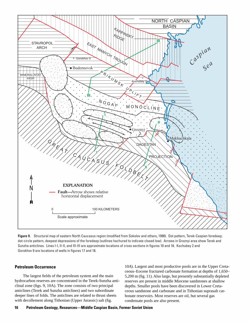
Original oil reserves of the TPS amount to 3.4 billion bar-rels whereas non-associated gas reserves are small (0.2 TCF). Almost all fields are controlled by structural traps related to thrusting of the Great Caucasus foldbelt onto the Mesozoic-Cenozoic epi-Hercynian platform. Oil and gas pools occur in reservoirs ranging in age from Late Jurassic to Miocene. Most original reserves (55 percent) are in Upper Cretaceous frac-tured limestone reservoirs of the Terek-Sunzha zone (fig. 9), but substantial reserves (30 percent) are also in middle Miocene sandstones. Reserves in Upper Jurassic and Lower Cretaceous carbonate and sandstone reservoirs are much smaller. The most important source rocks are probably shales of the Oligocene–lower Miocene Maykop series, but some endowment of hydrocarbons from older potential source rocks in the upper Eocene, Upper Jurassic, and Lower–Middle Juras-sic sections is possible.
Discovery History
Surface oil seeps in the Terek-Sunzha anticlinal zone near Groznyi (fig. 9) have been known for a long time, and oil was produced there from hand-dug wells starting in the early 1800’s. The first producing well was drilled into middle Miocene sand-stones of the Starogroznen field in 1893 by an Englishman, Alfred Stuart. The Berekey field in the South Dagestan area (western zone of the South Dagestan projection in fig. 9) was discovered in 1899. Oil production increased rapidly and reached a total of 8.8 million barrels by 1910.
After revolution in Russia, exploration resumed in the 1930’s, and several significant fields were discovered in shallow middle Miocene sandstones. However, major discoveries were made after World War II, in the 1950’s, when a number of large and highly productive pools were found in Upper Cretaceous rocks. Maximum production was reached in 1970–1971, after which production started to decline, as new discoveries were much smaller.
16 Petroleum Geology, Resources—Middle Caspian Basin, Former Soviet Union
Figure 9. Structural map of eastern North Caucasus region (modified from Sokolov and others, 1990). Dot pattern, Terek-Caspian foredeep; dot-circle pattern, deepest depressions of the foredeep (outlines hachured to indicate closed low). Arrows in Groznyi area show Terek and Sunzha anticlines. Lines I-I, II-II, and III-III are approximate locations of cross sections in figures 10 and 16. Kochubey 2 and Gorokhov 9 are locations of wells in figures 17 and 18.
MINERALOVOD HIGH
STAVROPOL ARCH
NORTH CASPIAN BASINKARPINSKYRIDGE
EAST MANYCH TROUGHGorokhov 9+
P R I K U MS K
U P L I F T
Casp
ian
Sea
III
III
+Kochubey 2
N O G A Y M O N O C L I N E
I
I
II
II
.
Groznyi
G
R E A TC A U C A S U S F O L D B E L T
DAGESTAN
PROJECTION
Makhachkala
0 100 KILOMETERS
N
Scale approximate
EXPLANATION
Fault—Arrow shows relative horizontal displacement
Budennovsk
Petroleum Occurrence
The largest fields of the petroleum system and the main hydrocarbon reserves are concentrated in the Terek-Sunzha anti-clinal zone (figs. 9, 10A). The zone consists of two principal anticlines (Terek and Sunzha anticlines) and two subordinate deeper lines of folds. The anticlines are related to thrust sheets with decollement along Tithonian (Upper Jurassic) salt (fig.
10
A
). Largest and most productive pools are in the Upper Creta-ceous–Eocene fractured carbonate formation at depths of 1,650–5,200 m (fig. 11). Also large, but presently substantially depleted reserves are present in middle Miocene sandstones at shallow depths. Smaller pools have been discovered in Lower Creta-ceous sandstone and carbonate and in Tithonian suprasalt car-bonate reservoirs. Most reserves are oil, but several gas condensate pools are also present.
Terek-Caspian Total Petroleum System
(110901), Middle Caspian B
asin, Russia17
A
B
Paleozoic-Triassic
Lower–Middle Jurassic
Upper Jurassic–Eocene
Upper Jurassic salt
Maykop Series
Middle–Upper Miocene
Pliocene-Quaternary
Thrust fault
Figure 10. Cross sections through Terek-Sunzha (A) and Dagestan (B) thrust belts (modified from Sobornov, 1995). Wedge-shaped frontal parts of thrust are intruded in Upper Jurassic salt (A) and Maykop plastic shales (A & B). Location of cross sections shown in figure 9.
TEREK-CASPIAN FOREDEEP
Sunzha Anticline Terek AnticlineN
NORTH CAUCASUS
Chernogor MonoclineSI I
20
5
10Km
DAGESTAN THRUST BELTII IIS N
STRATIGRAPHIC SEQUENCES
10 KILOMETERS
0
5
10Km 0
18 Petroleum Geology, Resources—Middle Caspian Basin, Former Soviet Union
South of the Terek-Sunzha zone, two small fields (Datykh and Benoy) have been discovered in thrust-related folds of the Caucasus foothills. Farther east and southeast, several oil and gas fields are found in the continuation of the thrust system where most reserves are also in Upper Cretaceous carbonate and Miocene sandstone reservoirs. Only one prospect has been drilled in the offshore portion of the thrust belt, and a gas con-densate flow was obtained from middle Miocene sandstones of the Inchkhe-more field.
North of the North Caucasus thrust system, a few noncom-mercial discoveries have been made on the Nogay monocline (fig. 9). Oil and gas were tested from Cretaceous rocks, largely from Upper Cretaceous carbonates. The traps are platform-type basement-related anticlinal uplifts different from traps of the thrust belt. In the absence of geochemical data, it is uncertain whether these fields constitute a part of the Terek-Caspian TPS, as inferred in this report, or whether they should be attributed to the Stavropol-Prikumsk TPS to the north.
Oils in Cretaceous and Mesozoic reservoirs are of low vis-cosity and gravity (mostly 37
°
–41
°
API). They have low sulfur and resin contents and a moderately high (5–10 percent) content of solid paraffin. GOR is typically high, varying in most pools from 1,400 to 2,600 ft
3
/bbl. Pools in Miocene rocks are largely less than 1,200 m deep and contain heavy, biodegraded oils with high (to 25 percent) resins content and low paraffin and sulfur contents. The oils are significantly devoid of paraffinic hydrocar-bons and largely consist of naphthenes and aromatics. Limited geochemical chromatography data suggest similarity of Miocene oils of the Terek-Sunzha zone to Mesozoic and Miocene oils of the Dagestan thrust belt (Sokolov and others, 1990). Data indi-cate that the oils were sourced from low to moderately mature source rock, probably from Maykop series shales. The data are inadequate to determine the affinity of Mesozoic oils of the Terek-Sunzha zone to the same group.
Stratigraphic Section
The basement of the Middle Caspian basin is a Hercynian accreted terrane, which includes several microcontinents. One of them, the North Caucasus microcontinent, crops out in the north-ern range of the foldbelt. The Paleozoic sedimentary cover of the microcontinent extends into the western area of the Terek-Cas-pian TPS, but its dimension is unknown. Triassic rocks, which fill rifts to the north of the area, may be present in the foredeep at great depths.
Basement or Triassic rocks are overlain by a thick Lower–Middle Jurassic clastic formation (fig. 11). North of the Cauca-sus Range, most of the formation is composed of Bajocian-Bathonian marine shales up to 2 km thick that include some sandstone beds. Thickness decreases northward, and the forma-tion pinches out on slopes of the Stavropol arch. Upper Jurassic-Neocomian rocks unconformably overlie the Middle Jurassic. The rocks were deposited in arid climatic conditions. The sec-tion consists of carbonates and includes thick (to 1,000 m) lower Tithonian salt in the western half of the TPS area. Thick Oxford-ian-Tithonian reefs are exposed in the northern zone of the Cau-casus, along the southern margin of the salt basin. To the north and west, the salt grades into red continental clastics. The
Aptian-Albian section is 500–700 m thick and is composed of marine shales with beds of glauconitic sandstones. Upper Creta-ceous rocks are carbonates and marlstones 300–600 m thick. Thickness increases to 1,400 m in a local depocenter just north-westward of the Dagestan projection (Bayrak, 1982). Paleocene-Eocene rocks are carbonates and marls of a condensed section only 50–100 m thick. The rocks were deposited in deep-water conditions; by the end of the Eocene the water depth could have exceeded 1,000 m (Berlin and Ulmishek, 1978).
The Upper Cretaceous–Eocene carbonate formation is overlain by the Maykop series of Oligocene–early Miocene age. In the TPS area, the series almost exclusively consists of shales and is up to 1,600 m thick. Shales in the lower part of the series were deposited in a deep-water basin inherited from Eocene time. The basin became progressively shallower by the end of Maykop deposition. The shales are undercompacted and over-pressured, and experienced plastic flow in zones of tectonic stress. The principal provenance areas were to the northeast; however, large olistostromes, which include huge blocks of underlying carbonates, reaching a cubic kilometer in volume, are present along the Caucasus and indicate the beginning of oro-genic uplift.
The middle Miocene through Quaternary sequence consists of coarsening-upward clastic rocks, which include some upper Miocene carbonate beds. This orogenic sequence fills a foredeep formed along the Caucasus front. Thickness of the rocks in the foredeep axial zone can exceed 5 km. To the north, the sequence rapidly thins onto the foreland slope.
Jurassic through Eocene rocks of the Terek-Caspian TPS were deposited on the southern continental margin of Eurasia. Sedimentation was characterized by a passive-margin regime because the TPS area was separated from the active Tethyan margin by the Transcaucasus microcontinent and the marginal sea of Great Caucasus. Provenance for clastic material was far to the north, on the Russian craton. First signs of Caucasus oro-genic uplift appeared in Oligocene time and progressively increased afterwards. However, not until late Miocene-Pliocene time did the orogen became the dominant source of clastic mate-rial and the present-day foredeep come into existence.
Source Rocks
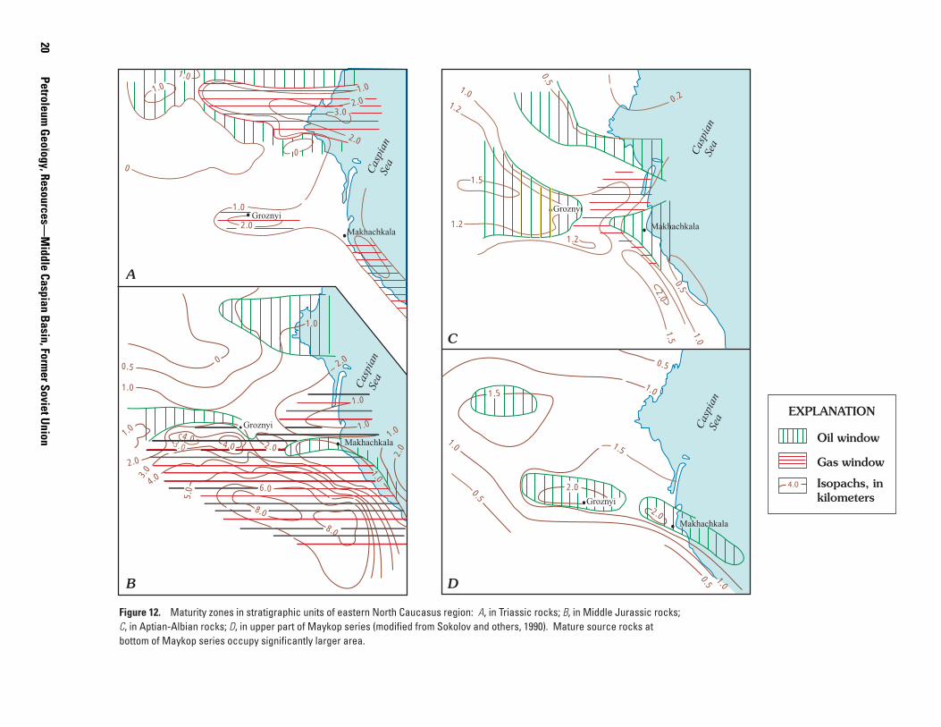
Geologic and limited geochemical data indicate that the most important source rocks of the Terek-Caspian TPS occur within the thick Maykop series (Oligocene–lower Miocene). The lower part of the series was deposited in a deep anoxic marine basin, which was gradually filled with clastic sediments of the upper part of the series (Ulmishek and Harrison, 1981). Lower Maykop shales and marlstones are characterized by variable, but commonly high (to 4.4 percent) TOC content and dominant type II kerogen. Hydrogen index in the lower to middle part of the oil window reaches 250–260 mg HC/g TOC. Toward the top of the Maykop series, TOC decreases to 1–2 percent, and organic mat-ter contains much more terrigenous constituents. In the depres-sions of the foredeep, the lower Maykop series occurs in the lower part of the oil window and into the gas window (fig. 12
D
).

Terek-Caspian Total Petroleum System
(110901), Middle Caspian B
asin, Russia19
Figure 11. Columnar stratigraphic section of Mesozoic-Tertiary rocks of Terek-Caspian petroleum system (modified from Ulmishek and Harrison, 1981).
Marine clastics
Carbonates
Salt and anhydrite
Stratigraphic gaps
Main reservoirs
Main regional seals
Terrestrial clastics
300-600 Thickness, in meters
EXPLANATION
Oxfordian
Kimmeridgian
Tithonian
Aalenian
Bajocian
Bathonian
Callovian
Neocomian
Barremian
Aptian
Albian
Cenomanian
Turonian
ConiacianSantonian
Maastrichtian
to 2
000
to 1
500
100-
1000
500-
900
250
400-
550
300-
600
Cre
tace
ous
Jura
ssic
Low
erLo
wer
Mid
dle
Upp
erU
pper
Upp
er
Upper
Upper
Lower
Lower
Lower
Middle
Mid
dle
Middle
May
kop
serie
s
Pal
eoge
ne
N
eoge
ne
Pal
eoce
neE
ocen
eO
ligoc
ene
Mio
cene
Plio
cene
KaraganChokrak
Khadum
Kuma
<50
5012
00-1
500
1200
1300
60-
100
100-
300
1000
-15
00
20Petroleum
Geology, Resources—
Middle Caspian B
asin, Former Soviet U
nion
Makhachkala
1.5
1.2
1.2
1.0
0.5
0.2
1.2
2.0
0.5
1.5
1.0
1.5
1.5
2.0
Groznyi
Groznyi
1.0
0.5 1.0
0.5
1.0
0.5
Makhachkala
Groznyi
Cas
pian
Sea
Cas
pian
Sea
Cas
pian
Sea
Cas
pian
Sea
1.0
2.0
. ..
.
.
0
0
3.02.0
1.0
2.0
1.0
1.0
Makhachkala
2.0
1.01.0
1.0
2.0
1.0
00.5
1.0
2.0
Groznyi4.0
4.03.0
8.0
8.0
6.0
1.0
5.0
.
4.03.0
2.0
1.0
2.0
Isopachs, in kilometers
Oil window
Gas window
Figure 12. Maturity zones in stratigraphic units of eastern North Caucasus region: A, in Triassic rocks; B, in Middle Jurassic rocks; C, in Aptian-Albian rocks; D, in upper part of Maykop series (modified from Sokolov and others, 1990). Mature source rocks at bottom of Maykop series occupy significantly larger area.
.
4.0
A
B
C
D
EXPLANATION
2.0
. Makhachkala

Terek-Caspian Total Petroleum System (110901), Middle Caspian Basin, Russia 21
?
?
?
?
PR
ES
ER
VA
TIO
N
CR
ITIC
AL
MO
ME
NT
GE
NE
RA
TIO
N-
TRA
P F
OR
MA
TIO
N
OV
ER
BU
RD
EN
RO
CK
RE
SE
RV
OIR
RO
CK
SE
AL
RO
CK
SO
UR
CE
RO
CK
RO
CK
UN
ITPE
TRO
LEU
MS
YS
TEM
EV
EN
TS
GEO
LOG
IC
TIM
ES
CA
LE
AC
CU
MU
LATI
ON
MIG
RA
TIO
N-
0
100
200
50
150
250
Paleogene
Cretaceous
Jurassic
Triassic
Permian
65
144
206
248 E
E
E
E
M
M
L
L
L
L
Neogene
24
Pal
Eoc
Olig
Mio
Plio
Figu
re 1
3.
Ter
ek-C
aspi
an p
etro
leum
sys
tem
eve
nts
char
t. Q
uest
ion
mar
ks in
dica
te u
ncer
tain
ty.

22 Petroleum Geology, Resources—Middle Caspian Basin, Former Soviet Union
Information on the presence of older source rocks in the TPS is uncertain because of limited geochemical data. Probable source rocks are argillaceous bituminous limestones of the upper Eocene Kuma Formation (fig. 11), which is 20–30 m thick and is separated from the base of the Maykop series by a 20-m bed of light foraminiferal limestone. TOC in rocks of the Kuma Forma-tion averages 2–2.5 percent. The formation was deposited in conditions similar to that of the Maykop series, but with lower input of clastic material (Berlin and Ulmishek, 1978).
North of the Caucasus Range, Middle Jurassic marine rocks include shale beds in which TOC averages 1.15 percent and reaches as much as 5–10 percent. Terrigenous organic matter dominates. The rocks are in the gas window over most of the area (fig. 12
B
) and could be a gas source for the petroleum sys-tem. Source rocks may also be present in the subsalt Upper Jurassic section. Rocks of this section have been erratically sam-pled only in a few wells drilled below the salt on the basin mar-gins, but the presence of source rocks may be inferred by analogy with the stratigraphically similar Amu-Darya basin. In both basins, salt was deposited in deep lagoons separated by reefs from the Tethyan ocean. Significant oil shows from subsalt carbonates in the marginal areas of the salt basin (Kosarev, 1982) and a gas flow of 9 MMCFD in the Datykh field support this supposition.
Although hydrocarbon generation from Jurassic source rocks could have started in Cretaceous time, generated hydrocar-bons were probably lost because of the absence of traps. The principal stage of maturation of younger source rocks took place after deposition of the Maykop series, during middle Miocene through Quaternary time, contemporaneously with thrusting and formation of traps (fig. 13).
Reservoir Rocks
Most oil and gas reserves of the TPS are in Upper Creta-ceous–Eocene carbonate reservoirs. Matrix porosity of Upper Cretaceous carbonates is low and commonly varies from a few to 10 percent; it is even lower in Paleocene-Eocene marlstones. Matrix permeability is negligible. Reservoir properties are enhanced by the presence of fractures and related vugs. Fractur-ing resulted from tectonic stress in thrust-related anticlines. Most pools are overpressured, and characteristic initial oil flow rates are in thousands of barrels per day.
The second important group of reservoirs is confined to sandstone beds of the middle Miocene Karagan and Chokrak Horizons (fig. 11). Seventeen to twenty-three sandstone beds occur much shallower than the Upper Cretaceous and possess excellent reservoir properties, although separate sandstone beds are laterally discontinuous and commonly pinch out. Thickness of each sandstone bed is usually less than 10 m. Lateral disconti-nuity and significant faulting result in a large number of hydro-dynamically isolated pools in many fields (for example, 65 pools in the Malgobek-Gorskaya field). Sandstone porosity varies from 15 to more than 30 percent, and permeability is commonly measured in hundreds of millidarcies.
Aptian-Albian sandstones and Neocomian and Upper Jurassic carbonates contain only a few petroleum accumulations.
Reservoir properties of both sandstones and carbonates at great depths are poor and mainly depend on fracturing.
Seal Rocks
The principal regional seal that controls hydrocarbon accu-mulations in the Mesozoic sequence is Maykop series shales. The shales are undercompacted and overpressured and are char-acterized by high plasticity in the subsurface. The series is from 750 to nearly 1,600 m thick and overlies most of the TPS area except for the Great Caucasus foothills, where it has been eroded. The seal directly overlies the principal reservoirs in the Upper Cretaceous–Eocene carbonate formation. Seals for pools in underlying Lower Cretaceous and Upper Jurassic rocks are dense shales and carbonates that probably would not be effective in the absence of Maykop shales.
Hydrocarbon accumulations in middle Miocene sandstones are sealed by alternating shale beds that range up to several tens of meters thick. In most uplifted anticlines, upper sandstone beds are exposed and either flushed by water or leak oil to the surface. An additional high-quality seal of potential importance is the Upper Jurassic (Tithonian) salt formation that is only locally deformed and is present west and northwest of the Dag-estan projection. A number of shows and a gas flow have been obtained from subsalt Jurassic carbonates, but this play remains unexplored. Because of the presence of a perfect salt seal above these shows, they may represent a separate petroleum system charged by Upper Jurassic and (or) Lower–Middle Jurassic source rocks.
Traps
Structural traps control all oil and gas fields of the TPS, although many particular pools are outlined by pinchouts of middle Miocene sandstones and by limits of fracturing in Upper Cretaceous–Eocene carbonates. Almost all discovered reserves are in anticlines related to leading edges of thrust sheets (fig. 10
A
), and only a few apparently noncommercial fields are known on the Nogay monocline in structural uplifts of the plat-form type. In the Terek-Sunzha zone, where the principal reserves of the petroleum system are concentrated, most discov-ered fields are in traps which form two east-to-west anticlinal lines, the Sunzha anticline on the south and the Terek anticline on the north (fig. 10
A
). The anticlines are expressed on the sur-face as two ridges. Deformation of Quaternary sediments and present-day seismicity indicate their continuing growth. Two less pronounced and much deeper structural lines containing several smaller fields are present to the north and south. The main detachment surface probably is in the Upper Jurassic salt formation. The salt itself is deformed by plastic flow and com-poses cores of the anticlines. It is interpreted from seismic data that thrust sheets of competent rocks intruded like wedges into undercompacted, plastic Maykop series shales. This intrusion caused antithetic reverse faults and thrusts of southern vergence to form in the upper part of the sedimentary section (Sobornov, 1995). Plastic deformation of Maykop shales resulted in

Terek-Caspian Total Petroleum System (110901), Middle Caspian Basin, Russia 23
additional faulting and folding of post-Maykop rocks, and the structure of the latter is substantially different from that of Upper Cretaceous rocks. Traps of the main structural lines are long and narrow anticlinal folds with closures reaching 1,500 m on Upper Cretaceous rocks.
Traps on the northeastern periphery of the Dagestan projec-tion are also thrust-related anticlines that are arranged in three structural lines. Progressively younger rocks crop out on consec-utively northeastward anticlinal lines. The easternmost line is located offshore where only one prospect has been drilled. In this part of the TPS area, Jurassic salt is absent, and the main detach-ment occurs in Lower–Middle Jurassic shales (fig. 10B). In other respects, these traps are similar to traps of the Terek-Sunzha zone, although the regional structure of the Dagestan zone is characterized by more intense deformation.
Assessment Units
Three assessment units are identified in the Terek-Caspian TPS (fig. 1). Assessed undiscovered oil and gas resources of these units are listed in table 1.
Assessment Unit 11090101, Foldbelt-Foothills
This unit occupies the front thrust system of the Caucasus foldbelt (fig. 1). Almost all discovered hydrocarbon reserves belong to this unit. Principal characteristics of undiscovered fields are probably similar to that of known fields. Along the foldbelt, the prospective area is limited by truncation of the May-kop series seal. Presently, the Terek-Sunzha zone contains the dominant reserves of the assessment unit. However, productive suprasalt Upper Jurassic through Tertiary rocks of this zone are substantially explored to depths of 5–5.5 km, and only smaller fields in deep satellite structures can be found. The deeper sub-salt Jurassic section occurs below the main detachment surface. Probably, it has different structural characteristics and is there-fore placed in a separate assessment unit (11090102, Terek-Sun-zha Subsalt Jurassic). The area between the Terek-Sunzha zone and exposed Caucasus folds is only sparsely explored. However, Cretaceous and younger rocks of this area are almost unde-formed, and structural prospects have been identified only in its southern part (Chernogor monocline; fig. 10A) where two dis-coveries have been made. Potential of the area is modest at best.
To the east of the Terek-Sunzha zone, the thrust belt is sparsely explored north of the Dagestan projection. Deformation is complex there (fig. 10B), and both leading edges and rear parts of the thrust sheets contain structural prospects. Until recently the quality of seismic data was inadequate for prospect mapping. The potential of the area is good. Light oil and gas condensate fields in both Cretaceous and middle Miocene reservoirs can be expected.
Farther to the southeast, the onshore area has been thor-oughly explored because structures are expressed in the surface geology. Two onshore anticlinal lines have been densely drilled. The anticlines are strongly faulted, and the sealing conditions are poor. Therefore, the fields are relatively small. The third, less deformed anticlinal line has been mapped offshore. One of the
anticlinal folds, the Inchkhe-more prospect, was drilled, and a gas condensate and oil discovery of medium size was made in middle Miocene rocks. The field has not been developed, proba-bly because of relatively deep water. The potential of the off-shore area is high, and large to medium-size light oil and gas fields with high condensate content can be expected.
Assessment Unit 11090103, Foreland Slope and Foredeep
This assessment unit covers the central, deepest part of the foredeep (except for the Terek-Sunzha zone) and the adjacent foreland slope north and northeast of the thrust belt (fig. 1). The area is virtually unexplored. Only a limited number of wells have been drilled with a few small discoveries in the western part of the unit. In the foredeep, depths to the potential targets are great and exceed 6 to 7 km in the deepest nearshore area and in the North Apsheron depression. Depths on the foreland slope are shallower, but the slope is significantly undeformed and large structural prospects have not been identified. Smaller, low-amplitude anticlinal structures are open to the north and north-east because of the regional dip of rocks toward the foredeep. The Tertiary section abruptly thins across the slope. Therefore, stratigraphic traps in the middle Miocene and possibly the lower part of upper Miocene rocks are likely to be present, but explo-ration for these traps in a frontier area at great depths is highly risky. Younger and shallower rocks are dominantly orogenic coarse clastics devoid of seals. The potential of the assessment unit is low.
Assessment Unit 11090102, Terek-Sunzha Subsalt Jurassic
This third assessment unit of the petroleum system includes subsalt Jurassic rocks of the Terek-Sunzha zone and surrounding areas (fig. 1). The area of the unit is defined by the pinchout boundary of the salt. Several attempts to drill into sub-salt rocks on structures of the Terek-Sunzha zone, where these rocks occur at depths of about 6 km, did not succeed because of technical difficulties. The rocks have been penetrated in mar-ginal areas of the salt basin. Shows were recorded and a gas flow was obtained from Oxfordian-Kimmeridgian carbonates in the Datykh field, which proves the presence of source rocks. The salt provides an excellent seal. Structure of subsalt rocks is poorly known, but some deformation related to stress from the Caucasus is probable. Reef buildups may be present on margins of the salt basin. High productivity of Jurassic subsalt carbon-ates is known in the tectonically and stratigraphically similar Amu-Darya basin east of the Caspian Sea where large oil and gas reserves have been found in structural traps and Oxfordian reefs. Productivity of Upper Jurassic subsalt carbonates and underlying Middle Jurassic clastics has been established in the East Kuban depression, which is located just west of the Miner-alovod high (fig. 9), in the Azov-Kuban basin. Potential of the assessment unit may be significant. Sour gas with a high con-densate content and light oil in shallower peripheral areas of the unit are the most likely hydrocarbons. Potential of the unit is assessed based on analogy with the Amu-Darya basin.

24 Petroleum Geology, Resources—Middle Caspian Basin, Former Soviet Union
Undiscovered ResourcesMFS Prob. Oil (MMBO)
(0-1) F95 F50 F5 Mean F95 F50 F5 Mean F95 F50 F5 Mean
Total: Assessed onshore portions of Middle Caspian Basin Province1,005 2,053 3,677 2,159 2,020 5,129 10,273 5,503 117 299 606 322
4,646 19,192 33,101 19,139 121 858 1,569 855
1.00 1,005 2,053 3,677 2,159 6,666 24,321 43,374 24,641 238 1,158 2,175 1,177
Total: Assessed offshore portions of Middle Caspian Basin Province822 2,683 4,793 2,728 1,689 5,527 10,726 5,766 95 320 625 334
1,457 9,552 17,811 9,278 38 149 318 158
1.00 822 2,683 4,793 2,728 3,146 15,079 28,537 15,044 133 469 943 492
Grand Total: Assessed portions of Middle Caspian Basin Province1,828 4,737 8,470 4,887 3,708 10,656 20,999 11,269 212 619 1,231 656
6,103 28,744 50,913 28,417 159 1,007 1,887 1,014
1.00 1,828 4,737 8,470 4,887 9,812 39,400 71,911 39,685 371 1,626 3,118 1,670
1.00
1.00
1.00
. .
Gas (BCFG) NGL (MMBNGL)
Table 1. Middle Caspian basin, Province 1109—Assessment results summary—allocated resources.[MMBO, million barrels of oil. BCFG, billion cubic feet of gas. MMBNGL, million barrels of naural gas liquids. MFS,minimum field size assessed (MMBO) or BCFG). Prob., probability (including both geologic and accessibility probabilities) of at least one field equal to or greater than the MFS. Results shown are fully risked estimates. For gas fields, all liquids areincluded under the NGL (natural gas liquids) category. F95 represents a 95 percent change of at least the amount tabulated. Other fractiles are defined similarly. Fractiles are additive under the assumption of perfect positive correlation. Shading indicates not applicable]
Undiscovered ResourcesMFS Prob. Oil (MMBO)
(0-1) F95 F50 F5 Mean F95 F50 F5 Mean F95 F50 F5 Mean
Terek-Caspian Total Petroleum System
7 556 1,012 1,728 1,060 1,359 2,555 4,560 2,707 80 153 277 16242 3,775 7,048 11,874 7,329 107 209 370 220
1.00 556 1,012 1,728 1,060 5,134 9,603 16,435 10,036 188 362 647 382
7 543 988 1,687 1,034 1,327 2,495 4,452 2,643 79 149 270 15942 944 1,762 2,969 1,832 27 52 93 55
1.00 543 988 1,687 1,034 2,271 4,257 7,421 4,475 105 201 363 214
20 0 264 633 283 0 1,291 3,270 1,413 0 77 198 85120 0 10,488 18,245 10,051 0 620 1,139 603
0.85 0 264 633 283 0 11,779 21,516 11,464 0 697 1,337 688
7 142 254 445 269 201 377 693 403 12 23 42 2442 295 623 1,201 670 6 13 26 14
1.00 142 254 445 269 496 1,000 1,894 1,073 18 35 68 38
Gas (BCFG) NGL (MMBNGL)
Foldbelt-Foothills Assessment Unit (50.6% of undiscovered oil fields and 80% of undiscovered gas fields allocated to ONSHORE province 1109)
Foldbelt-Foothills Assessment Unit (49.4% of undiscovered oil fields and 20% of undiscovered gas fields allocated toOFFSHORE province 1109)
Terek-Sunzha Subsalt Jurassic Assessment Unit (100% of undiscovered oil fields and 100% of undiscovered gas fields allocated to ONSHORE province)
Foreland Slope and Foredeep Assessment Unit (59.5% of undiscovered oil fields and 59.5% of undiscovered gas fields allocated to ONSHORE province)
1.00
1.00
0.85
1.00
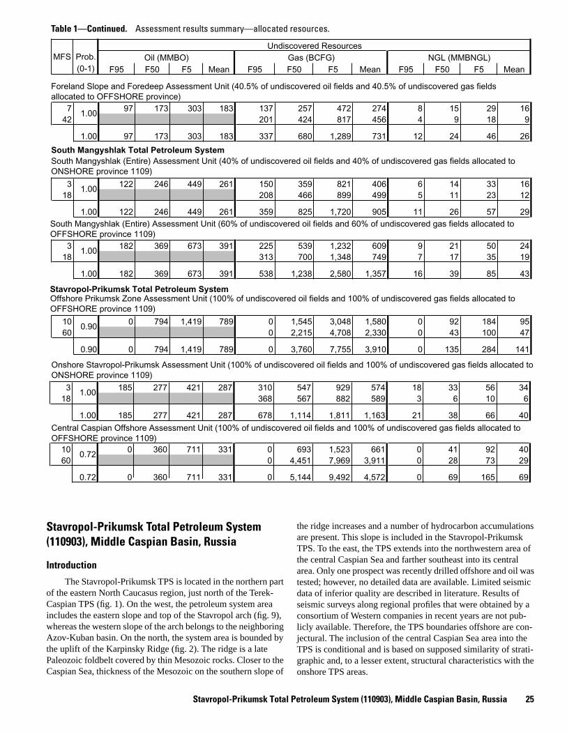
Stavropol-Prikumsk Total Petroleum System (110903), Middle Caspian Basin, Russia 25
Undiscovered ResourcesMFS Prob. Oil (MMBO)
(0-1) F95 F50 F5 Mean F95 F50 F5 Mean F95 F50 F5 Mean
7 97 173 303 183 137 257 472 274 8 15 29 1642 201 424 817 456 4 9 18 9
1.00 97 173 303 183 337 680 1,289 731 12 24 46 26
South Mangyshlak Total Petroleum System
3 122 246 449 261 150 359 821 406 6 14 33 1618 208 466 899 499 5 11 23 12
1.00 122 246 449 261 359 825 1,720 905 11 26 57 29
3 182 369 673 391 225 539 1,232 609 9 21 50 2418 313 700 1,348 749 7 17 35 19
1.00 182 369 673 391 538 1,238 2,580 1,357 16 39 85 43
Stavropol-Prikumsk Total Petroleum System
10 0 794 1,419 789 0 1,545 3,048 1,580 0 92 184 9560 0 2,215 4,708 2,330 0 43 100 47
0.90 0 794 1,419 789 0 3,760 7,755 3,910 0 135 284 141
Gas (BCFG) NGL (MMBNGL)
1.00
1.00
1.00
0.90
South Mangyshlak (Entire) Assessment Unit (60% of undiscovered oil fields and 60% of undiscovered gas fields allocated to OFFSHORE province 1109)
Offshore Prikumsk Zone Assessment Unit (100% of undiscovered oil fields and 100% of undiscovered gas fields allocated to OFFSHORE province 1109)
Foreland Slope and Foredeep Assessment Unit (40.5% of undiscovered oil fields and 40.5% of undiscovered gas fieldsallocated to OFFSHORE province)
South Mangyshlak (Entire) Assessment Unit (40% of undiscovered oil fields and 40% of undiscovered gas fields allocated to ONSHORE province 1109)
Table 1—Continued. Assessment results summary—allocated resources.
3 185 277 421 287 310 547 929 574 18 33 56 3418 368 567 882 589 3 6 10 6
1.00 185 277 421 287 678 1,114 1,811 1,163 21 38 66 40
10 0 360 711 331 0 693 1,523 661 0 41 92 4060 0 4,451 7,969 3,911 0 28 73 29
0.72 0 360 711 331 0 5,144 9,492 4,572 0 69 165 69
1.00
0.72
Onshore Stavropol-Prikumsk Assessment Unit (100% of undiscovered oil fields and 100% of undiscovered gas fields allocated toONSHORE province 1109)
Central Caspian Offshore Assessment Unit (100% of undiscovered oil fields and 100% of undiscovered gas fields allocated toOFFSHORE province 1109)
Stavropol-Prikumsk Total Petroleum System (110903), Middle Caspian Basin, Russia
Introduction
The Stavropol-Prikumsk TPS is located in the northern part of the eastern North Caucasus region, just north of the Terek-Caspian TPS (fig. 1). On the west, the petroleum system area includes the eastern slope and top of the Stavropol arch (fig. 9), whereas the western slope of the arch belongs to the neighboring Azov-Kuban basin. On the north, the system area is bounded by the uplift of the Karpinsky Ridge (fig. 2). The ridge is a late Paleozoic foldbelt covered by thin Mesozoic rocks. Closer to the Caspian Sea, thickness of the Mesozoic on the southern slope of
the ridge increases and a number of hydrocarbon accumulations are present. This slope is included in the Stavropol-Prikumsk TPS. To the east, the TPS extends into the northwestern area of the central Caspian Sea and farther southeast into its central area. Only one prospect was recently drilled offshore and oil was tested; however, no detailed data are available. Limited seismic data of inferior quality are described in literature. Results of seismic surveys along regional profiles that were obtained by a consortium of Western companies in recent years are not pub-licly available. Therefore, the TPS boundaries offshore are con-jectural. The inclusion of the central Caspian Sea area into the TPS is conditional and is based on supposed similarity of strati-graphic and, to a lesser extent, structural characteristics with the onshore TPS areas.

26Petroleum
Geology, Resources—
Middle Caspian B
asin, Former Soviet U
nion
>700
1200
450
500
400
>100
030
0
Cre
tace
ous
0-20
00-
600
0-30
010
0-20
045
0-55
030
0-40
0
Per
mia
nTr
iass
icJu
rass
ic
Upp
er
Upp
erU
pper
Upp
erLo
wer
Low
erLo
wer
Low
erM
iddl
e
Mid
dle
Kum
an
Ole
neki
anA
nisi
anLa
dini
anC
arni
anN
oria
nR
haet
ian
Formation
Zurmutin
Zakum
Novokolod
Demyanov
Kultay
Aalenian
Bajocian
Bathonian
Callovian
Oxfordian
Kimmeridgian
Tithonian
Valanginian
Hauterivian
Barremian
Aptian
Albian
Neo
com
ian
Cenomanian
Turonian
Coniacian
Santonian
Campanian
Maastrichtian
Nef
teku
mK
izly
arN
ogay
Jura
ssic
Pal
eoce
ne
Neo
gene
Pal
eoge
ne
Eoc
ene
Olig
ocen
eM
ioce
neP
lioce
ne
May
kop
serie
s
Kuma
Khadum
Lower
Lower
Lower
Middle
Middle
Middle
Upp
er
Upper
Upper
50-1
0050
-100
1200
-140
020
0-30
010
0-30
010
0-40
0
Figure 14. Columnar stratigraphic section of Mesozoic-Tertiary rocks of Stavropol-Prikumsk petroleum system (modified from Ulmishek and Harrison, 1981).
Indu
an
Shale
Sandstone
Conglomerate
Carbonates
Volcanics
Coal
Stratigraphic gap
Regional seal
Main reservoir
450-550 Thickness, in meters
EXPLANATION
Stavropol-Prikumsk Total Petroleum System (110903), Middle Caspian Basin, Russia 27
Original hydrocarbon reserves of the TPS are approxi-mately 1.8 billion barrels of oil and 14 TCF of gas. Productivity has been established in a wide stratigraphic range, from the Tri-assic to the Miocene. The largest gas reserves are found in lower Maykop (Oligocene) sandstones in structural traps on the Stavropol arch and its slope. Discovered oil reserves are mostly in Triassic, Jurassic, and Cretaceous reservoirs in structural traps of the Prikumsk uplift (figs. 2, 9). The largest part of original reserves is in Aptian-Albian sandstone pays, but Triassic, Neoco-mian, and Upper Cretaceous carbonates and Middle Jurassic sandstones also contain many oil and gas condensate pools. Source rocks are present in the Triassic, Middle Jurassic, and Paleogene sections, but they are geochemically poorly character-ized, and their relative endowment in hydrocarbon reserves is largely unknown.
Discovery History
Deep drilling in the petroleum system area began after World War II. The giant (nearly 8 TCF) North Stavropol–Pela-giada gas field in the central part of the Stavropol arch was dis-covered in 1951, followed by discoveries of several gas fields in the same area in the late 1950’s. In the 1960’s and 1970’s, the main exploration efforts shifted to the east of the Stavropol arch, and several tens of oil and gas condensate fields of large to small size were discovered in Jurassic and Cretaceous reservoirs in structural traps of the Prikumsk uplift and Karpinsky Ridge. All sizable structures mapped in Jurassic and Cretaceous rocks were drilled during this time period, and attempts to explore for strati-graphic traps were largely unsuccessful. In the late 1970’s and later, deeper Triassic rocks became the principal exploration objective, and more than a dozen oil fields were found in struc-tural and paleogeomorphic traps. Several oil fields were also found in self-sourced fractured shales in the lower part of the Maykop series. The first offshore prospect was recently drilled in the Severny area located close to the boundary between the Stavropol-Prikumsk and South Mangyshlak TPS (fig. 1), and a large oil and gas discovery was reported (The Wall Street Jour-nal, 2000).
Oil and gas production in the area reached its peak in 1969–1971, after which the decline in production started and continued until present.
Petroleum Occurrence
The principal gas reserves of the Stavropol-Prikumsk TPS are in structural traps on the Stavropol arch and in the western-most part of the Prikumsk uplift. More than 90 percent of the reserves are in sandstone reservoirs of the lower Maykop Kha-dum Horizon (fig. 14). A few pools have been found in Aptian-Albian sandstones. The gas is dry. Presently, gas reserves are essentially depleted.
The main oil-productive area is the Prikumsk uplift, which contains numerous isometric and variously elongated local struc-tures. Nearly all structures are productive, but most fields are not large. Each field contains from one to six pays. Almost the entire sedimentary succession from the Triassic to the Miocene is
productive. In Triassic rocks, larger pools are in carbonates of the Neftekum Formation (fig. 14), mainly in the zone of reef facies along the southern border of the East Manych trough (figs. 2, 9). A few small pools have been found in carbonates of the Middle Triassic Kizlyar Formation. Most reservoirs contain oil.
The Middle Jurassic section contains about 20 pools in sandstone reservoirs. A few small pools have been found in the Lower Jurassic. Oil pools dominate in the more western areas, whereas gas condensate pools are found to the east. Similar areal distribution of oil and gas condensate is characteristic of Upper Jurassic and Lower Cretaceous rocks. The Upper Jurassic and Neocomian contain both sandstone and carbonate reservoirs. The Aptian-Albian clastic section contains the largest portion of TPS reserves. Most productive are lower Aptian sandstones, in which original daily yields of wells reached 2,000 barrels. The upper Aptian shale is a regional seal. In the northern areas, the seal becomes sandy, and leaks hydrocarbons, and younger Albian rocks are most productive (Klubov and Blokhina, 1988; Krylov, 1987). A few small oil pools have been found in Upper Cretaceous carbonate reservoirs.
Established productivity of Tertiary rocks of the Prikumsk uplift is limited. In the 1980’s, several oil pools were found in unconventional reservoirs. These pools are located in the western part of the Prikumsk uplift and the adjacent slope of the Stavropol arch. Reservoir rocks are organic-rich shales in the lower part of the Maykop series. Oil pools are substantially over-pressured and controlled by zones of fracturing that are not related to local structures. Productivity of wells is highly vari-able and ranges from several to 800 b/d (Bochkarev and Ilchenko, 1986). Identification of prospects of this type is diffi-cult because the reservoirs cannot be mapped by seismic sur-veys. Higher in the section, only a few small dry gas fields are found in sandstone beds of the middle Maykop series of the Pri-kumsk uplift.
About 20 gas condensate and oil fields are known north of the Prikumsk uplift. Most of these fields are on the southern slope of the eastern Karpinsky Ridge. All fields are small to medium in size. Almost entire reserves are found in Aptian-Albian clastic reservoirs in structural traps. A few pools are present in Jurassic sandstones and Upper Cretaceous carbonates. Most fields are depleted.
An apparently large oil and gas discovery made offshore in the summer of 2000 is in a large structural trap. Productive are Middle Jurassic sandstones. Reported reserves are 2.2 billion barrels of oil equivalent of which 60 percent is oil (The Wall Street Journal, 2000). No further data on the discovery are avail-able at this time.
Composition of oils and condensates of the Stavropol-Pri-kumsk TPS is diverse. Modern geochemical data that would allow correlation of oils with potential source rocks are lacking, and only data on group composition of oils and condensates and some gas chromatography data are available. From these data, Russian geologists identified two (Sokolov and others, 1990) or three (Vinogradova and others, 1985; Dzhabrailov and others, 1991) families of oils.
Oils of the first family occur in lower Maykop, Upper Cre-taceous, and uppermost Albian reservoirs at depths of 2,300–2,900 m where reservoir temperatures are 115°–120° C. The oils

28 Petroleum Geology, Resources—Middle Caspian Basin, Former Soviet Union
Triassic rocks absentBoundaries of large structures,sawteeth toward structural lows
+++Boundaries of smaller structuresMiddle Caspian basin boundary
EXPLANATION
Elista
ArzgirGraben Horst
Uplift
V-M
NalchikGroznyi
^^^^^^^^^^^^
^^
^^
^
^^^^
^^^
^
^^
^
^
^^
^^
^^
^
^^
^
^^
^
^^
^
^^
^^
^^^
^^
^^
^^
^
^^
^^
^
^^
^^
^
^
^
^^ ^
^ ^^ ^
^^
^
^^^^^^^^^^^^
^^^^^
^^
^^
^
^^
^
^
^^
^
NORTH CASPIAN BASIN
Figure 15. Structural map of Triassic taphrogenic sequence of eastern North Caucasus region (modified from Letavin, 1978). V-M, Velichaev-Maksimokum uplift. No scale.
West ManychGraben
Dadyn
East Manych Graben
Talov Terrace
Kuma - NogayZone
Berezkin Depression
Ku
ma River
Tere
kRi
ver
SeaCaspian
Volg
aRiv
er
N

Stavropol-Prikumsk Total Petroleum
System (110903), M
iddle Caspian Basin, Russia
29
1000
2000
3000
4000
5000
6000
7000
3000
4000
5000
6000
1000
2000
0 0
0 15 30 45Oil and gas pools
N
m
m KARPINSKY RIDGEEAST MANYCH GRABEN
Basement
J
K1
K2
Pg-Mio
PromyslovKhudzhur
Krasny KamyshanMezhozerZakum
PlavnenOzek-SuatZimnya StavkaMekteb Soyuz
PRIKUMSK UPLIFT
Basement
Plio - Q
NOGAYMONOCLINE
TukuyBerezkinS
Figure 16. Cross section through Stavropol-Prikumsk petroleum system (modified from Sokolov and others, 1990). Location of cross section shown in figure 9. �, Paleozoic; �, Triassic; J, Jurassic; K1, Lower Cretaceous; K2, Upper Cretaceous; Pg, Paleogene; Mio, Miocene; Plio, Pliocene; Q, Quaternary.
III III
KILOMETERSFault
EXPLANATION
���
�
�
�
30 Petroleum Geology, Resources—Middle Caspian Basin, Former Soviet Union
are relatively heavy (30°–38° API) and contain up to 0.3 percent sulfur and 7 percent asphaltenes. Solid paraffin content does not exceed 12 percent. The second family of oils occurs in Jurassic and Lower Cretaceous rocks. Most oils are found at depths of 3,070–3,750 m under temperatures of 130°–150°C. These oils are lighter (37°–45° API) and less sulfurous, and they contain only 0.3–3.3 percent asphaltenes. The oils are highly paraffinic (to 30 percent) and are characterized by a pristane/phytane ratio greater than 2 and a cyclohexanes/cyclopentanes ratio of 0.4–0.6. The third family includes oils reservoired in Triassic rocks. Most of the oils occur at depths of 3,400–5,000 m under temper-atures of 140°–170° C. They are light, low-sulfur oils with high concentrations of solid paraffins (30–50 percent) and low resin and asphaltene contents. Pristane to phytane ratio ranges from 1.1 to 1.5, and cyclohexanes are more abundant than cyclopen-tanes (average ratio 1.5). However, mixing of different oil types is common. In several fields, oils of the Triassic type occur in Jurassic and Cretaceous reservoirs, and some Triassic pools con-tain oils more similar to the Jurassic-Cretaceous type. Many compostional differences between oil types seem likely to have no genetic significance, and more data are needed to identify genetic oil families.
Stratigraphic Section
Maximum thicknesses of the Triassic sequence, which overlies the Paleozoic folded basement, are limited to grabens of the rift system (figs. 15, 16). The Upper Permian(?)–lower Induan Kuman Formation occurs at the base of the sequence (fig. 14). The formation comprises continental coarse red clas-tics in the lower part and marine gray clastics with thin carbon-ate beds in the upper part. The rest of the Lower Triassic is mostly a carbonate section on the Prikumsk uplift and basinal calcareous shales in the East Manych and Arzgir grabens. Mid-dle Triassic through Carnian rocks are marine clastics with car-bonate beds. The Norian-Rhaetian is unconformable over various older rocks, including the basement, and was formed after cessation of rifting. The section is mainly composed of calc-alkalic volcanics, including thick lava flows. The volcanics constitute a part of the extensive (about 4,000 km) Cimmerian volcanic arc related to a subduction zone on the southern active margin of Eurasia (Zonenshain and others, 1990). Maximum thicknesses of the volcanics (more than 1,000 m) are found in the Berezkin depression where older Triassic rocks are absent (fig. 15). To the north, the section is much thinner or absent because of pre-Jurassic erosion. On the Prikumsk uplift, various Triassic rocks subcrop at the pre-Jurassic unconformity.
The Lower Jurassic section is present chiefly on the Karpinsky Ridge and is formed by continental coaly clastics. Marine clastic rocks dominate in the Middle Jurassic. Lower–Middle Jurassic and overlying Upper Jurassic and Neocomian rocks onlap the slope of the Stavropol arch and successively pinch out. Thin Aptian-Albian clastic rocks directly overlie the basement on the top of the arch. Upper Jurassic rocks are present only in the eastern areas of the TPS. They are mainly dolomites with increasing amounts of clastics to the west and anhydrites in the upper part of the section to the east. Unconformities are present at the bottom of the carbonate formation and at the top of the Kimmeridgian. Tithonian rocks are absent.
The Neocomian is composed of calcareous clastic rocks with carbonate beds in the Valanginian and Hauterivian. The section thins to the west and pinches out on the slope of the Stavropol arch. Aptian and Albian rocks are thick clastics. These rocks gradually become more shaly eastward. The Upper Cretaceous is about 200 m thick on the Stavropol arch and thickens to 400 m eastward and southeastward. It comprises various carbonate rocks, including limestone, marlstone, and chalk, with subordinate shale beds.
Paleocene-Eocene and Maykop series (Oligocene–lower Miocene) rocks unconformably overlie the Upper Cretaceous and are represented by two types of sections (Berlin and Ulmishek, 1978). The first type is developed on the Stavropol arch and is more similar to the sections of the adjacent Azov-Kuban basin west of the arch. The Paleocene-Eocene is thick (800-900 m) and is composed of shallow-water shales, silt-stones, and sandstones. The overlying Maykop series is, on the contrary, relatively thin (600–700 m). It consists of basal sand-stones of the Khadum Horizon (100–150 m thick) and overlying shales with thin sandstone and siltstone beds. The rest of the TPS area, including offshore, has the second type of section. The Paleocene-Eocene is a thin (50–100 m) condensed section of greenish-gray clayey limestones and calcareous shales deposited in a deep-water basin uncompensated by sediments (Berlin and Ulmishek, 1978). The section includes the upper Eocene Kuma Formation, a 20-m-thick bed of black organic-rich marlstone accumulated in anoxic environments (fig. 14). The deep-water basin was filled by the Maykop series, which is 1,200–1,400 m thick. The lower part of the series, including the Khadum Horizon, is composed of deep-water, organic-rich, anoxic black shales. Upward in the section, clastics are progres-sively more shallow-water in origin. Sandstone beds are present in the middle and upper part of the series in northeastern areas proximal to the provenance of coarse clastic material. The sand-stones and interbedded shales form a series of prograding clas-tic wedges (clinoforms). Nine major clinoforms and corresponding sedimentary cycles are identified (Kunin and others, 1987). To the west and southwest, sandstones pinch out, and the section is almost exclusively composed of gray and black shales.
Middle–upper Miocene rocks unconformably overlie the Maykop series. The rocks are marine clastics with beds of coquina. Maximum thicknesses are in southeastern areas, and the section thins to the north and west. Upper Pliocene sedi-ments occur at the top of the sedimentary cover.
Source Rocks
No modern geochemical data exist for source rocks of the TPS. However, indirect geologic and some geochemical data suggest that probable source rocks are present in several strati-graphic intervals. Distribution of oil and gas condensate fields in Triassic reservoir rocks of the Prikumsk uplift clearly indi-cates the presence of indigenous source rocks. Almost all wells were targeted at Neftekum Formation reef and back-reef car-bonate reservoirs (fig. 14) of the Prikumsk uplift (Kuma-Nogay zone, and Velichaev-Maksimokum uplift in fig. 15). These shal-low-water facies are commonly poor in organic matter; rare
Stavropol-Prikumsk Total Petroleum
System (110903), M
iddle Caspian Basin, Russia
31
DE
PT
H, I
N M
ET
ER
S
0
2000
4000
6000
8000
50 C
100 C
150 C
200 C
AGE, IN MILLIONS OF YEARS
Q + Pliocene
Early mature (oil)0.5 to 0.7 (%Ro)
Mid mature (oil)0.7 to 1.0 (%Ro)
Late mature (oil)1.0 to 1.3 (%Ro)
Main gas generation1.3 to 2.6 (%Ro)
Sandstone
Sand and shale
Shale
Limestone
Basement
t=0
U + M Miocene
EXPLANATION
300 200 100 0
L CretaceousU Jurassic
L + M Jurassic
Triassic
Basement
Kochubey 2
Figure 17. Maturation model for Kochubey 2 well, eastern part of Stavropol-Prikumsk total petroleum system. Approximate location of well shown in figure 9.
o
o
o
o
L Miocene + Oligocene
Permian Triassic Jurassic Cretaceous PalEoceneOligoMiocenePliocene
Upper Cret. + Eo.
32Petroleum
Geology, Resources—
Middle Caspian B
asin, Former Soviet U
nion Early mature (oil)0.5 to 0.7 (%Ro)
Mid mature (oil)0.7 to 1.0 (%Ro)
Late mature (oil)1.0 to 1.3 (%Ro)
Main gas generation1.3 to 2.6 (%Ro)
Sandstone
Sand and shale
Shale
Limestone
Basement
0
2000
1000
3000
4000
5000t=0200300 100 0
Gorokhov 9
Q + Pliocene
U + M Miocene
L Miocene + Oligocene
Upper Cret. + Eocene
Basement
Aptian-Albian
Figure 18. Maturation model for Gorokhov 9 well, central part of Stavropol-Prikumsk total petroleum system. Approximate location of well shown in figure 9.
DE
PT
H, I
N M
ET
ER
S
AGE, IN MILLIONS OF YEARS
Permian Triassic Jurassic Cretaceous PalEoceneOligoMiocenePliocene
EXPLANATION
50 C o
100 Co
150 Co
Stavropol-Prikumsk Total Petroleum System (110903), Middle Caspian Basin, Russia 33
shale beds have TOC not exceeding 3.5 percent (Mirzoev and Dzhaparidze, 1979). In the East Manych and Arzgir grabens, shallow-water carbonates of the Neftekum and Kultay Forma-tions grade into thin-bedded, dark-colored, deep-water clayey limestones and shales (Letavin, 1988; Bochkarev and others, 1992). Few wells have been drilled in the grabens, and cores are scarce. The principal Triassic source rocks are probably present among these deep-water facies (Klubov and Blokhina, 1988; fig. 1). In the eastern part of the East Manych graben and farther east offshore, Triassic source rocks occur at depths of about 5 km and more. They reached the main oil-generation stage in Cretaceous time and entered the gas window during deposition of the Oli-gocene–lower Miocene Maykop series (fig. 17). Gas condensate pools are present in adjacent areas of the Prikumsk uplift. To the west, the source rocks occur at depths of 3.5–4 km and are pres-ently in the oil window. Triassic reservoirs contain light oils there. Triassic source rocks are probably absent in the central Caspian area.
Higher in the section, source rocks are present in the Lower–Middle Jurassic section, but their geochemical character-ization is insufficient for precise identification of specific favor-able layers. Judging from lithologic descriptions, most probable source rocks occur in the lower Bajocian strata, which are com-posed of dark-gray and black marine shales containing ammo-nites and foraminifers (Letavin, 1988). The strata are about 200 m thick in the eastern areas and pinch out to the west toward the Stavropol arch (fig. 1). Measured TOC in shales averages 1.15 percent and reaches 3.2 percent in separate layers (Sokolov and others, 1990; Mirzoev and Dzhaparidze, 1979). Kerogen is of mixed types II and III; the latter is more abundant. The source rock section extends offshore and probably is present in the cen-tral Caspian part of the TPS, although the kerogen may be more coaly there. Bajocian source rocks are in the oil window over most of the onshore area. On the east of this area and probably offshore, the rocks the entered gas window in late Miocene time (fig. 17).
Many geologists believe that shale beds of the thick Aptian-Albian marine clastic section have generated oil found in inter-bedded sandstone reservoirs. However, the source characteristics of the shales seem to be poor. The shales were deposited in sub-oxic environments; they are of dark-gray and greenish-gray color and include lenses and thin layers of siltstone. TOC in the shales averages 0.4–0.6 percent, and only in separate thin beds does it reach 1.5–2 percent. The kerogen is of mixed types II and III; type II is more abundant. The rocks reached early maturity in Oligocene–early Miocene time, during deposition of the Maykop series (figs. 17, 18). Presently they occur in the oil window over the entire area (Sokolov and others, 1990; Nazarevich and oth-ers, 1983). The contribution of Aptian-Albian source rocks in oil and gas reserves is probably insignificant, as also indicated by the apparent similarity of oils found in Jurassic and Cretaceous reservoirs.
Source rocks in the lower part of the Maykop series and underlying thin Paleocene-Eocene section (primarily the Kuma Formation—see fig. 14), which are so important in the Terek-Caspian TPS, are also present in the Stavropol-Prikumsk TPS. The best source rocks are located in the upper part of the Kha-dum Horizon and directly overlying shale beds and are 30–40
m thick. This section is formed by thin (1 mm–3 cm) alterna-tion of black and gray shale layers. The rocks were deposited in a deep-water basin in strongly anoxic environments (Berlin and Ulmishek, 1978; Burlakov and others, 1987). TOC in black lay-ers varies from 5 to 8 percent; in gray layers it does not exceed 2 percent (Bochkarev and Ilchenko, 1986). Type II kerogen dominates in the source rocks. On the eastern slope of the Stavropol arch and western Prikumsk uplift, this section contains self-sourced overpressured oil pools in fractured shales. Fractures are oriented along sedimentary planes and are genetically related to hydrocarbon generation. Despite high res-ervoir temperatures (120°–130° C) the organic matter is at early stages of maturity corresponding to the upper and middle parts of the oil window (figs. 17, 18). Oils in these shales are highly naphthenic. They contain abundant isoprenoids, 6–11 percent waxes, and 7–9 percent resins, and are characterized by odd/even n-alkanes predominance (Vinogradova and others, 1989).
On the Stavropol arch, the Khadum Horizon is composed of gas-bearing sandstones, and overlying and underlying organic-rich shales are immature. They are also immature on the Karpin-sky Ridge. Offshore, the source rocks extend over the entire petroleum system area. However, in the northern part of the off-shore area, which is located toward the main provenance of clas-tic material (Onischenko, 1986), low source rock quality may be expected.
The role of Paleogene source rocks in productivity of older reservoirs is not clear because of scarcity of data. Compositional differences of Upper Cretaceous and uppermost Albian oils com-pared to oils in older Lower Cretaceous and Jurassic reservoirs may be related to different source rocks of the Paleogene and Middle Jurassic sections, respectively. Mixing of oils in these younger reservoirs from both sources is also probable.
In conclusion, the principal oil and gas condensate reserves of the TPS, which are concentrated on the Prikumsk uplift, were generated by at least three source rock formations in the Lower Triassic, Middle Jurassic, and Maykop series (fig. 19). Oil and gas condensate fields on the Karpinsky Ridge probably result from lateral migration of hydrocarbons from the Triassic and possibly Middle Jurassic sources of the East Manych trough. Large gas fields of the Stavropol arch were charged by long-range lateral migration from adjacent depressions, including those located in the Azov-Kuban basin. The principal stage of formation for all oil and gas fields of the TPS was during and after deposition of the thick Maykop series.
Reservoir Rocks
Productive reservoir beds are present through most of the TPS sedimentary section, from the Triassic to the Miocene. Sev-eral of these beds contain the bulk of oil and gas reserves; others only sporadically contain small pools. The principal Triassic pay that is productive in more than 10 fields consists of carbonate rocks of the Neftekum Formation (fig. 14). Most of these fields are located along the southern border of the East Manych trough (fig. 15) where the formation is largely composed of reef facies. Reservoir rocks are fractured vuggy limestones and dolomites.

34 Petroleum Geology, Resources—Middle Caspian Basin, Former Soviet Union
PR
ES
ER
VA
TIO
N
CR
ITIC
AL
MO
ME
NT
GEN
ERAT
ION
-
TRA
P F
OR
MA
TIO
N
OV
ER
BU
RD
EN
RO
CK
RE
SE
RV
OIR
RO
CK
SE
AL
RO
CK
SO
UR
CE
RO
CK
RO
CK
UN
ITPE
TRO
LEU
MS
YS
TEM
EV
EN
TS
GEO
LOG
IC
TIM
ES
CA
LE
AC
CU
MU
LATI
ON
MIG
RA
TIO
N-
0
100
200
50
150
250
Paleogene
Cretaceous
Jurassic
Triassic
Permian
65
144
248
206
E
E
E
E
M
M
L
L
L
L
Neogene
24
Pal
Eoc
Olig
Mio
Plio
Figure 19. Stavropol-Prikumsk petroleum system events chart.

Stavropol-Prikumsk Total Petroleum System (110903), Middle Caspian Basin, Russia 35
Measured porosities reach 10 percent; permeability is completely controlled by fracturing (Stasenkov and others, 1983). Best res-ervoir rocks occur at the top of the formation under the unconfor-mity surface; the rocks are commonly too friable to be cored.
In the Jurassic section, major oil and gas pays are Bajocian sandstones that have porosities of 12–16 percent and permeabili-ties to 100–150 mD. Eastward, the amount of clay material increases, and reservoir properties of the sandstones deteriorate. The Lower Cretaceous section contains 12 pays productive in different fields; most of the pays are sandstones. The principal reserves are concentrated in uppermost Barremian and lower Aptian sandstone beds. Another important producer is a sand-stone bed at the top of the Albian. Porosity of the sandstones var-ies widely in different fields from 12 to 24 percent; permeability ranges from tens to hundreds of millidarcies.
Fractured shale reservoirs in the lower part of the Maykop series are poorly characterized by laboratory measurements. In situ porosity is evaluated at 10–12 percent (Klubova, 1988), and permeability is highly variable, as indicated by a wide range of initial oil flow rates. Sandstones and siltstones of the Oligocene Khadum Horizon, containing large gas accumulations on the Stavropol arch, possess excellent reservoir properties. Porosity reaches 40 percent, and permeability ranges from hundreds of millidarcies to several darcies.
Seal Rocks
The principal regional seal of the Stavropol-Prikumsk TPS, similarly to that of the Terek-Caspian TPS, is thick overpres-sured Maykop series shales. Above this seal, only a few small pools of dry gas, possibly of biogenic origin, are present. Although Maykop shales provide hydrodynamic isolation of the entire underlying sequence, they directly seal only gas pools on the Stavropol arch. Oil and gas pools in Mesozoic strata are sealed by various shale beds. Most important among them are thick and areally extensive shale beds in the upper Bajocian and upper Aptian, which seal most oil and gas reserves of the Pri-kumsk uplift.
Traps
The bulk of oil and gas reserves of the Stavropol-Pri-kumsk petroleum system are found in structural traps, although outlines of particular pools are often affected by lithologic changes of reservoir rocks. The number and characteristics of structural traps vary over the TPS area. Structural traps on the Stavropol arch that contain large gas accumulations are gentle, irregularly shaped uplifts underlain by basement highs. These traps were probably formed during Pliocene-Quaternary time when the arch was uplifted about 500 m (Shardanov and Romanov, 1988).
The Prikumsk uplift contains a large number of small to medium-size local structures. The structures are isometric or slightly elongated in various directions. Their closures are largest in Jurassic horizons and gradually decrease upward. In the west-ern part of the uplift, the structures are traced upward to the bot-tom and locally to the top of the Maykop series. Toward the east,
structural closures disappear in progressively older rocks. In areas adjacent to the Caspian Sea, the structures are present only in Jurassic rocks, whereas Cretaceous and younger rocks are undeformed. This situation may be expected to extend some dis-tance offshore; however, large structural uplifts have been identi-fied farther east, close to the eastern boundary of the petroleum system where recent discovery in the Severny area is located. Most local structures on the Prikumsk uplift are basement-related, but apparently some are underlain by erosional highs at the top of the Triassic. The morphological characteristics of the traps suggest that they are old and were formed as drape struc-tures, although slight posthumous structural growth could have occurred locally. Traps on the Karpinsky Ridge are similar to those on the Prikumsk uplift. Rocks filling the East Manych and Arzgir grabens are almost undeformed and few local structures are known there. The character of traps in Triassic rocks is poorly understood. Apparently, basement-related structural traps, reefs, and erosional highs under the pre-Jurassic unconformity, and combinations of those are present.
Despite significant facies variability of clastic rocks, only several small pools have been found in stratigraphic traps related to up-dip pinchout of sandstone beds. Most of these pools occur in the Albian (Chepak, 1987). Probably, very little if any explo-ration specifically targeted at stratigraphic traps has taken place. Finally, traps for oil pools in shale reservoirs of the lower May-kop series are related to fracture zones. Discovered traps are located in depressions and on slopes of local uplifts. Fracturing was caused by hydrocarbon generation and associated increase of pore pressure. Some geologists believe that the location of the fracture zones is related to basement faults (Klubova, 1988), but little evidence exists.
Assessment Units
Three assessment units are identified in the Stavropol-Pri-kumsk TPS. Undiscovered oil and gas resources of these units are listed in table 1.
Assessment Unit 11090302, Onshore Stavropol-Prikumsk
This unit covers the entire onshore area of the system (fig. 1). The Stavropol arch on the west of the unit area (fig. 2) con-tains large, presently almost depleted gas fields. The arch is thor-oughly explored, and the potential for new somewhat significant discoveries in structural traps is negligible. The Neocomian and lower Aptian sections onlap and thin updip on the eastern slope of the arch. Gas discoveries in stratigraphic traps are possible there, but the fields will probably be small. The rest of the assess-ment unit is also significantly explored. All known local uplifts in Jurassic and Cretaceous rocks have been drilled, and only small additional structural prospects can be found. However, there was little or no exploration specifically targeted at strati-graphic traps. Considering significant lithologic variability of many Jurassic and Cretaceous reservoir beds, a potential for stratigraphic hydrocarbon accumulations exists. However, mostly small fields can be expected.
Underlying Triassic rocks are significantly less explored and their geology is not well understood. Seismic resolution is

36 Petroleum Geology, Resources—Middle Caspian Basin, Former Soviet Union
poor, and only high-amplitude basement-related uplifts, which are also expressed in Jurassic and Cretaceous rocks, and Triassic erosional highs can be mapped. The presence of Lower Triassic reefs, basinal rocks, and associated facies suggests additional petroleum potential. On analogy with discovered fields, mainly oil accumulations will be found.
All discovered oil accumulations in fractured shales of the lower Maykop series were found accidentally in wells targeted at deeper horizons. The potential distribution of pools of this type is not clear, and seismic methods are inadequate to map prospects. However, relatively shallow depths and high oil qual-ity can make exploration attractive. Mostly small size fields will be found, but their number may be significant. The exploration efficiency will increase as more data on distribution of fracture zones become available.
Assessment Unit 11090301, Offshore Prikumsk Zone
This unit includes the offshore area into which the known onshore structures likely extend (fig. 1). Only one prospect has been drilled in the unit; therefore, risk related to possible changes in geologic characteristics should be included in resource assessment. The southeastern boundary of the unit is the inferred Agrakhan-Guryev strike-slip(?) fault (fig. 2). It is likely that the Triassic East Manych graben was connected with the Central Mangyshlak rift system of the same age and was off-set along the strike-slip fault during the post-rift compressional stage. Thus, Lower Triassic source rocks and associated reef facies of the East Manych graben probably extend across the entire southern part of the assessment unit. The Lower–Middle Jurassic section that contains Bajocian source rocks onshore is certainly present over the entire assessment unit and is mature at least in its southern part. However, the quality of source rocks is likely to deteriorate eastward because the presence of source rocks, especially for oil, in this interval in the adjacent South Mangyshlak TPS is doubtful. Maykop source rocks might also be of poorer quality because of closer proximity to provenance for coarse clastic material. In the northern half of the assessment unit, the Maykop series is thin and certainly devoid of source rocks. Thus, the presence of source rocks can be expected only in the southern areas of the assessment unit. Updip migration of hydrocarbons into the more northern areas of the unit is possi-ble, based on analogy with fields on the Karpinsky Ridge onshore. However, the exploration risk is higher.
Results of seismic work conducted offshore in recent years are not available, and information on the presence of structural traps is sparse. The Prikumsk uplift, which contains most of structural traps and major hydrocarbon reserves onshore, loses its structural expression in the nearshore area. In addition, base-ment-related local structures in the eastern part of the uplift are expressed only in Jurassic rocks, whereas younger beds are undeformed. Russian maps show several large structures in the eastern part of the assessment unit, but more detailed data are not available. Apparently, one of these structures in the Severny area that is located close to the boundary with the South Mangy-shlak TPS produced the recent large discovery. This discovery was made after resource assessment of the Middle Caspian basin had been completed. If the size of the new field is confirmed, it
raises chances for further significant discoveries, upgrades potential of the assessment unit, and eliminates risks that were included in the resource assessment.
Assessment Unit 11090303, Central Caspian Offshore
This assessment unit occupies the central part of the Cas-pian Sea and is included in the Stavropol-Prikumsk TPS condi-tionally (fig. 1). No wells have been drilled, and data on only a few regional seismic profiles crossing the area are available. Based on these profiles, the unit area is occupied by a structural monocline descending southwestward to the Terek-Caspian foredeep. Depth to the basement varies from 3 to 6 km (Lebedev and others, 1987). To the southeast, the basement becomes shal-lower toward the Karabogaz arch. Comparison of the Jurassic through Tertiary rocks east and west of the Caspian Sea suggests that the stratigraphy of these rocks in the assessment unit is sim-ilar to that of the eastern Prikumsk uplift.
A risk involved in resource assessment of this unit is sub-stantially higher than that for assessment unit 11090301. The risk is primarily related to the presence and quality of source rocks and traps. Unlike in the previous assessment unit, Triassic rifts and associated source rocks almost certainly do not extend into the area. The quality of Jurassic source rocks is uncertain. In general, the rocks become more continental and gas-prone east-ward. Source rocks at the bottom of the Maykop series are present, but they are probably immature in the southeastern part of the unit. In the rest of the unit area, the feasibility of migration of hydrocarbons from Maykop source rocks to the principal Jurassic and Lower Cretaceous reservoirs is doubtful because mostly gentle, platform-type structures can be expected. Many of these structures might be open updip on the monocline. Larger structural traps have been mapped in the southeastern part of the unit, on the flank of the Karabogaz arch, but source rocks in this area are absent, and exploration should rely upon possible long-range lateral migration. Gas is more likely hydro- carbons in these traps. Stratigraphic traps updip of the mono-cline in Jurassic–Lower Cretaceous and possibly middle Miocene rocks are probable, but most fields will be small. In conclusion, petroleum potential of the assessment unit is proba-bly rather low.
References Cited
Bayrak, I.K., 1982, Neftegazonosnost mezozoya krayevykh progibov Predkavkazya (Petroleum productivity of Mesozoic rocks of the North Caucasus foredeeps): Moscow, Nauka, 82 p.
Berlin, Yu.M., and Ulmishek, G.F., 1978, Lithologic composition and paleo-geographic and paleogeomorphic conditions of sedimentation of Kuma and Maykop rocks of the Caspian region, in Geodekian, A.A., ed., Protsessy neftegazoobrazovaniya v akvatorii Kaspiyskogo morya (Processes of oil and gas generation in the Caspian Sea): Moscow, P.P. Shirshov Institute of Oceanology, p. 17–27.
Bobylev, V.V., and Grechishnikov, N.P., 1983, Petroleum productivity of Triassic rocks in areas between the Caspian Sea and the Aral Lake: Geologiya Nefti I Gaza, no. 8, p. 34–36.
References Cited 37
Bochkarev, A.V., and Ilchenko, V.P., 1986, Geochemical and hydrogeo-logical indications of connection between organic matter and oils in Maykop series rocks of central North Caucasus, in Yeremenko, N.A., and Maximov, S.P., eds., Aspekty geneticheskikh svyazey neftey I organicheskogo veshchestva porod (Aspects of genetic relationship of oils and organic matter in rocks): Moscow, Nauka, p. 73–75.
Bochkarev, A.V., Kirina, L.V., Evik, V.N., and Serkov, A.A., 1992, Gas pools in Triassic shales of the Arzgir trough in North Caucasus: Geologiya Nefti I Gaza, no. 1, p. 22–26.
Burlakov, I.A., Khadisova, R.A., and Leschinskaya, T.B., 1987, Geochemi-cal characteristics of Oligocene oil-productive shales of eastern North Caucasus: Geologiya Nefti I Gaza, no. 4, p. 40–43.
Chepak, G.N., 1987, Causes of low efficiency of exploration for pools con-trolled by lithologic traps in platform conditions: Geologiya Nefti I Gaza, no. 3, p. 12–14.
Cherbyanova, L.F., Popkov, V.I., and Pronyakov, V.A., 1984, Lithologic characteristics and reservoir properties of Triassic carbonate and volcanogenic rocks of South Mangyshlak: Geologiya Nefti I Gaza, no. 11, p. 55–59.
Dikenshtein, G.Kh., Maksimov, S.P., and Semenovich, V.V., eds., 1983, Neftegazonosnye provintsii SSSR (Petroleum provinces of the USSR): Moscow, Nedra, 272 p.
Dmitriev, L.P., Kozmodemyansky, V.V., Khafizov, I.A., Korsun, P.E., and Pankov, V.A., 1982, Main results and directions of geologic and geo-physical exploration for nonanticlinal traps of Mangyshlak: Geologiya Nefti I Gaza, no. 10, p. 21–26.
Dzhabrailov, M.O., Roitman, A.Ya., Shapiev, D.Sh., and Landa, E.M., 1991, Geochemical criteria for prediction of productivity of structures in Triassic rocks of the platform part of Dagestan, in Mekhtiev, Sh.F., Ali-Zade, A.A., and Buniat-Zade, Z.A., eds., Problemy neftegazonos-nosti Kavkaza (Problems of petroleum potential of the Caucasus): Moscow, Nauka, p. 71–76.
Environmental System Research Institute, Inc., 1992, ArcWorld 1:3M dig-ital database: Environmental System Research Institute, Inc. (ESRI), available from ESRI, Redlands, CA, scale: 1:3,000,000.
Florensky, P.V., Karachentseva, I.M., Konokhova, N.I., Orel, A.V., and Salina, L.S., 1975, Triassic rocks of South Mangyshlak—A new pro-ductive sequence: Geologiya Nefti I Gaza, no. 8, p. 35–41.
Kabanova, Z.V., and Braslavskaya, G.G., 1979, Relationship of oil and gas source rocks with reservoir rocks and seals in the Mesozoic section of the Turan plate, in Vassoevich, N.B., and Timofeev, P.P., eds., Neftematerinskiye svity I printsipy ikh diagnostiki (Petroleum source rocks and principles of their identification): Moscow, Nauka, p. 230–234.
Klubov, V.A., and Blokhina, G.Yu., 1988, Paleogeologic conditions of for-mation of oil and gas pools in the North Caucasus region, in Yere-menko, N.A., ed., Indicatory obstanovok formirovaniya zalezhey uglevodorodov (Indicators of conditions of hydrocarbon pool forma-tion): Moscow, Nauka, p. 14–24.
Klubova, T.T., 1988, Glinistye kollektory nefti I gaza (Shale oil and gas res-ervoirs): Moscow, Nedra, 158 p.
Kosarev, V.S., 1982, Petroleum potential of Upper Jurassic rocks of the western Terek-Caspian depression: Geologiya Nefti I Gaza, no. 2, p. 17–23.
Krylov, N.A., ed., 1987, Tektonika I neftegazonosnost Severnogo Kavkaza (Tectonics and petroleum productivity of North Caucasus): Moscow, Nauka, 96 p.
Krylov, N.A., 1971, Obshchiye osobennosti tektoniki I neftegazonosnosti molodykh platform (General features of tectonics and distribution of oil and gas on young platforms): Moscow, Nauka, 156 p.
Kunin, N.Ya., Kosova, S.S., Medvedev, E.N., and Pustovoyt, O.Yu., 1987, Study of the Maykop clinoforms in eastern North Caucasus: Geologiya Nefti I Gaza, no. 10 p. 18–24.
Larichev, V.V., 1988, Formation of hydrochemical and hydrodynamic anomalies in pre-Jurassic rocks of South Mangyshlak: Geologiya Nefti I Gaza, no. 8, p. 44–47.
Lebedev, L.I., Aleksina, I.A., Kulakova, L.S., and Bars, E.A., 1987, Kaspiyskoye more: geologiya I neftegazonosnost (Caspian Sea: geology and petroleum potential): Moscow, Nauka, 296 p.
Letavin, A.I., ed., 1988, Mezozoysko-Kaynozoyskiye kompleksy Pred-kavkazya (Mesozoic-Cenozoic sequences of North Caucasus): Mos-cow, Nauka, 94 p.
Letavin, A.I., 1978, Tafrogennyi kompleks molodoy platformy yuga SSSR (Taphrogenic complex of the young platform of the southern USSR): Moscow, Nauka, 148 p.
Makhutov, K., 1989, Productivity of zones of decompaction in pre-Juras-sic rocks of South Mangyshlak: Geologiya Nefti I Gaza, no. 1, p. 16–19.
Mirzoev, D.A., and Dzhaparidze, L.I., 1979, Determination of catagenesis of dispersed organic matter and stages of oil and gas generation in sedimentary sequences of the platform cover of eastern North Cau-casus, in Vassoevich, N.B., and Timofeev, P.P., eds., Neftematerin-skiye svity i printsipy ikh diagnostiki (Oil-source formations and principles of their identification): Moscow, Nauka, p. 200–209.
Murzagaliev, D.M., 1996, Rifting and petroleum productivity of Mangy-shlak: Geologiya Nefti I Gaza, no. 5, p. 36–39.
Nazarevich, B.P., Nazarevich, I.A., and Stafeev, A.N., 1983, Maturation history of Lower Cretaceous rocks of the central and eastern North Caucasus and their petroleum productivity, in Khain, V.E., Sokolov, B.A., and Nazarevich, I.A., Success in development of sedimentary-migrational theory of oil and gas generation: Moscow, Nauka, p. 120–132.
Onischenko, B.A., 1986, Depositional conditions and petroleum produc-tivity of Maykop series rocks of North Caucasus: Geologiya Nefti I Gaza, no. 2, p. 23–27.
Orudzheva, D.S., Popkov, V.I., and Rabinovich, A.A., 1985, New data on the geology and petroleum potential of pre-Jurassic rocks of South Mangyshlak: Geologiya Nefti I Gaza, no. 7, p. 17–22.
Petroconsultants, Inc., 1996, Petroleum exploration and production data-base: Petroconsultants, Inc., P.O. Box 740619, 6600 Sands Point Drive, Houston TX 77274-0619, U.S.A., or Petroconsultants, Inc., P.O. Box 152, 24 Chemin de la Mairie, 1258 Perly, Geneva, Switzerland.
Polyakova, I.D., 1977, Regularities in deposition of organic matter in old sedimentary rocks, in Kontorovich, A.E., and Uspensky, V.A., eds., Rasseyannoye organicheskoye veshchestvo gornykh porod I meto-dy yego izucheniya (Dispersed organic matter in sedimentary rocks and methods of its study): Novosibirsk, Russia, Nauka, p. 42–55.
Popkov, V.I., 1991, Role of horizontal compression in formation of platform anticlines of Mangyshlak and Ustyurt: Geologiya Nefti i Gaza, no. 7, p. 2–6.
Shablinskaya, N.V., Budanov, G.F., and Lazarev, V.S., 1990, Promezhu-tochnye kompleksy platformennykh oblastey SSSR i ikh neftega-zonosnost (Intermediate complexes of the platform regions of the USSR and their petroleum potential): Leningrad, Nedra, 180 p.
Shardanov, A.N., and Romanov, Yu.A., 1988, Neotectonics and distribu-tion of hydrocarbon accumulations in the North Caucasus region, in Yeremenko, N.A., ed., Indikatory obstanovok formirovaniya zalezhey uglevodorodov (Indicators of conditions of hydrocarbon pools for-mation): Moscow, Nauka, p. 24–32.

38 Petroleum Geology, Resources—Middle Caspian Basin, Former Soviet Union
Sobornov, K.O., 1995, Geologic framework of the petroleum productive thrust belt of eastern Caucasus: Geologiya Nefti I Gaza, no. 10, p. 16–21.
Sokolov, B.A., Korchagina, Yu.I., Mirzoev, D.A., Sergeeva, V.N., Sobornov, K.O., and Fadeeva, N.P., 1990, Neftegazoobrazovaniye I neftegazonakopleniye v Vostochnom Predkavkazye (Oil and gas generation and accumulation in eastern North Caucasus): Moscow, Nauka, 204 p.
Stasenkov, V.V., Letavin, A.I., Kopylov, N.T., Savelyeva, L.M., Sharafutdi-nov, F.G., and Mirzoev, D.A., 1983, Potential of exploration for strati-graphic oil and gas pools in Permian-Triassic rocks of eastern North Caucasus: Geologiya Nefti I Gaza, no. 5, p. 23–27.
The Wall Street Journal, June 5, 2000, Lukoil’s Caspian oil field finds a natural-gas snag. Page number unavailable.
Timurziev, A.I., 1984, Characteristics of reservoir rocks and hydrocarbon pools in low permeable sections and improvement of methods for their prediction: Geologiya Nefti I Gaza, no. 11, p. 49–54.
———1986, Mechanism of formation of oil and gas pools of South Mangyshlak: Geologiya Nefti I Gaza, no. 10, p. 25–31.
Tverdova, R.A., 1988, Organic matter in rocks of South Mangyshlak as indicator of genetic and phase type of pools, in Chakhmakhchev, V.A., ed., Migratsiya I fazovyi sostav uglevodorodov (Migration and phase composition of hydrocarbons): Moscow, Nauka, p. 57–65.
Tverdova, R.A., Chakhmakhchev, V.A., Vinogradova, T.L., Doshko, A.S., and Yakubson, Z.V., 1982, Changes in low boiling liquid hydrocar-bons of dispersed organic matter in Triassic rocks of Mangyshlak, in Vassoevich, N.B., Polster, L.A., and Bazhenova, O.K., eds., Metody
otsenki nefte- i gazomaterinskogo potentsiala sedementitov (Meth-ods for evaluation of oil and gas generative potential of sedimentary rocks): Moscow, Nauka, p. 80–91.
Ulmishek, G.F., 1990, Uzen field, in Beaumont, E.A., and Foster, N.H., com-pilers, Structural traps IV, Treatise of petroleum geology, Atlas of oil and gas fields: American Association of Petroleum Geologists, p. 281–297.
Ulmishek, Gregory, and Harrison, W., 1981, Petroleum geology and resource assessment of the Middle Caspian basin, USSR, with spe-cial emphasis on the Uzen field: Argonne National Laboratory Report ANL/ES-116, 147 p.
U.S. Geological Survey World Energy Assessment Team, 2000, U.S. Geo-logical Survey World Petroleum Assessment 2000 – Description and results: U.S. Geological Survey Digital Data Series DDS-60, 4 CD-ROMs.
Vinogradova, T.L., Chakhmakhchev, V.A. and Doshko, A.S., 1985, Predic-tion of phase composition and genetic types of hydrocarbon pools in Mesozoic rocks of eastern North Caucasus: Geologiya Nefti I Gaza, no. 5, p. 42–49.
Vinogradova, T.L., Yakubson, Z.V., Doshko, A.S., Belous, I.I., and Shashi-na, T.A., 1989, Comparative geochemical study of organic matter and oils in Paleogene rocks of eastern North Caucasus, in Aksenov, A.A., and Chakhmakhchev, V.A., eds., Geochemical problems of petro-leum resource assessment: Moscow, IGIRGI, p. 36–49.
Zonenshain, L.P., Kuzmin, M.I., and Natapov, L.M., 1990, Tectonics of lithospheric plates of the USSR territory (Tektonika litosfernykh plit territorii SSSR), Volume 2: Moscow, Nedra, 236 p.