PERMANENT ANCHORS FASTER RESPONSE … response times and minimal environmental impact ... times and...
78
Transcript of PERMANENT ANCHORS FASTER RESPONSE … response times and minimal environmental impact ... times and...


PERMANENT ANCHORSfor
FASTER RESPONSE TIMES and MINIMAL ENVIRONMENTAL IMPACT
PERMANENT ANCHORSfor
FASTER RESPONSE TIMES and MINIMAL ENVIRONMENTAL IMPACT
DEE BRADLEY, DOWCAR Environmental Mgmt., Inc.
CARL J. OSKINS,DOWCAR Environmental Mgmt., Inc.
CHALMER BITSOINAVAJO NATION OIL & GAS Company
-
Running Horse Pipeline

PERMANENT BOOM DEPLOYMENT ANCHORS for FASTER RESPONSETIMES and MINIMAL ENVIRONMENTAL IMPACT
January, 2007,
NAVAJO NATION OIL and GAS COMPANY -
RUNNING HORSE PIPELINEand
DOWCAR
Environmental Management, Inc.
CREATED an ENVIRONMENTAL/ENGINEERING PROJECTto
to DESIGN, DEVELOP and IMPLEMENT a PROGRAM forof
PRE-SETTING PERMANENT BOOM DEPLOYMENT ANCHORSfrom
SHIPROCK, NEW MEXICO to
MEXICAN HAT, UTAH on the
SAN JUAN RIVER.

PERMANENT BOOM DEPLOYMENT ANCHORS for FASTER RESPONSE TIMES and MINIMAL ENVIRONMENTAL IMPACT
WHY SELECT and POSITION
PERMANENT BOOM DEPLOYMENT ANCHORS on the
SAN JUAN RIVER in the
FOUR CORNERS AREAof the
SOUTHWEST USA ?
WHY SELECT and POSITION
PERMANENT BOOM DEPLOYMENT ANCHORS on the
SAN JUAN RIVER in the
FOUR CORNERS AREAof the
SOUTHWEST USA ?
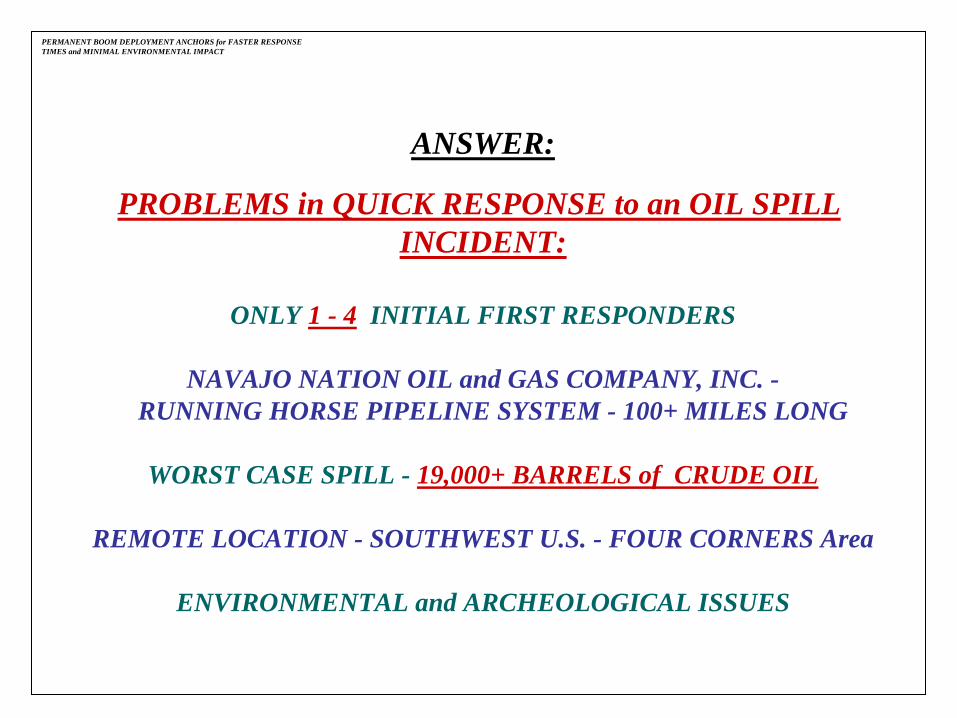
ANSWER:
PROBLEMS in QUICK RESPONSE to an OIL SPILL INCIDENT:
ONLY 1 -
4
INITIAL FIRST RESPONDERS
NAVAJO NATION OIL and GAS COMPANY, INC. -RUNNING HORSE PIPELINE SYSTEM -
100+ MILES LONG
WORST CASE SPILL -
19,000+ BARRELS of CRUDE OIL
REMOTE LOCATION -
SOUTHWEST U.S. -
FOUR CORNERS Area
ENVIRONMENTAL and ARCHEOLOGICAL ISSUES
PERMANENT BOOM DEPLOYMENT ANCHORS for FASTER RESPONSE TIMES and MINIMAL ENVIRONMENTAL IMPACT

ISSUES to be ADDRESSED to COMPLETE PROGRAM:
NAVAJO NATION TRIBAL LAND OWNERSHIP
ENVIRONMENT WHERE ANCHORS to be PLACED
HISTORICAL and ARCHEOLOGICAL ISSUES
LAND USAGE REQUIREMENTS for EACH ANCHOR SITE
PERMISSION to PLACE ANCHORS from:
BUREAU of LAND MANAGEMENT
NAVAJO NATION TRIBAL GOVERNMENT
PERMANENT BOOM DEPLOYMENT ANCHORS for FASTER RESPONSE TIMES and MINIMAL ENVIRONMENTAL IMPACT

NAVAJO NATION OIL & GAS CO., Running Horse Pipeline - San Juan River Geographical Response Plan for Inland Waters Oil Spills©Updated March, 2009 -
(Boom Deployment, Containment & Recovery Sites)Prepared By DOWCAR Environmental Management, Inc.
Site 1 to 9Mexican Hat, UT to Shiprock, NM
Approximately 99.34 Road
Miles
Shiprock
New MexicoArizonaUtah Colorado
Scale 1 : 550,500 Map Rotation: 0° Magnetic Declination: 11.8°E
Hwy 163
Hwy 262
Hwy 262
Hwy 163
Hwy 160
Mexican Hat
PERMANENT BOOM DEPLOYMENT ANCHORS for FASTER RESPONSE TIMES and MINIMAL ENVIRONMENTAL IMPACT

Site 1 to 9Mexican Hat, UT to Shiprock, NM
Approximately 68.45 River
Miles
NAVAJO NATION OIL & GAS CO., Running Horse Pipeline - San Juan River Geographical Response Plan for Inland Waters Oil Spills©Updated March, 2009 -
(Boom Deployment, Containment & Recovery Sites)Prepared By DOWCAR Environmental Management, Inc. Scale 1 : 375, 000 Map Rotation: 0° Magnetic Declination: 11.9°E
Mexican Hat
New
Mex
icoArizona
Utah
Col
orad
o
ShiprockShiprock
Mexican Hat
PERMANENT BOOM DEPLOYMENT ANCHORS for FASTER RESPONSE TIMES and MINIMAL ENVIRONMENTAL IMPACT

1.
DEVELOP a GEOGRAPHICAL OIL SPILL RESPONSE PLAN (GRP)
for the SAN JUAN RIVER
from SHIPROCK, NM
to MEXICAN HAT, UT.
2.
PRE-DESIGNATE
OIL SPILL BOOM DEPLOYMENT, CONTAINMENT and RECOVERY SITES
in the GEOGRAPHICAL OIL SPILL RESPONSE PLAN
on the SAN JUAN RIVER between these two locations.
PERMANENT BOOM DEPLOYMENT ANCHORS for FASTER RESPONSE TIMES and MINIMAL ENVIRONMENTAL IMPACT
STEPS in PLACING PERMANENT ANCHORS:

PERMANENT BOOM DEPLOYMENT ANCHORS for FASTER RESPONSE TIMES and MINIMAL ENVIRONMENTAL IMPACT
SITES 1 -
9Updated: March, 2009
Copy No.: DOWCAR1
RUNNING HORSE PIPELINESTORAGE TANK FACILITY
SAN JUAN RIVERSAN JUAN RIVERGEOGRAPHICAL RESPONSE PLANGEOGRAPHICAL RESPONSE PLAN
for INLAND OIL SPILLSfor INLAND OIL SPILLS
BOOM DEPLOYMENT, CONTAINMENT & RECOVERY

PERMANENT BOOM DEPLOYMENT ANCHORS for FASTER RESPONSE TIMES and MINIMAL ENVIRONMENTAL IMPACT
NNOGC - RUNNING HORSE PIPELINE
SAN JUAN RIVER GEOGRAPHICAL RESPONSE PLAN
CONSIST of:
TABLE of CONTENTS
• INTRODUCTION
• RECOMMENDED BOOM DEPLOYMENT SITES
• BOOM DEPLOYMENT SITES and DISTANCE MAPS
• INDIVIDUAL PRE-DESIGNATED BOOM DEPLOYMENT SITES

PERMANENT BOOM DEPLOYMENT ANCHORS for FASTER RESPONSE TIMES and MINIMAL ENVIRONMENTAL IMPACT
NNOGC - RUNNING HORSE PIPELINE
SAN JUAN RIVER GEOGRAPHICAL RESPONSE PLAN
PRE-DESIGNATED BOOM DEPLOYMENT SITES
CONSIST of :
“NINE”PRE-DESIGNATED PRIMARY and SECONDARY
BOOM DEPLOYMENT, CONTAINMENT and RECOVERY SITES
on the SAN JUAN RIVER.

PERMANENT BOOM DEPLOYMENT ANCHORS for FASTER RESPONSETIMES and MINIMAL ENVIRONMENTAL IMPACT
PRE-DESIGNATED BOOM DEPLOYMENT SITES
Site: 1. Mexican Hat Boat Ramp, Mexican Hat, UT -
Primary Site* (BLM Land)
Site: 2. Hwy 191 Bridge Area, Bluff, UT
-
Alternate Site (Navajo Nation Land)
Site: 3. Sand Island Recreational Area, Bluff, UT -
Primary Site* (BLM Land)
Site: 4. Bluff, South of UT Hwy 163 and County Road 2451
-
Primary Site* (BLM Land)
Site: 5. Montezuma Creek Water Tower, Montezuma Creek, UT
-
Primary Site* (Navajo Nation Land)
Site: 6. Montezuma Creek Bridge, Montezuma Creek, UT
-
Alternate Site (Navajo Nation Land)
Site: 7. Aneth Community School Area, Aneth, UT
-
Primary Site* **(Navajo Nation Land)
Site: 8. Shiprock Bridge Area -
North, US Hwy 64
-
Primary Site -
New Site**(Navajo Nation Land)
Site: 9.
Shiprock Gaging Station, US Hwy 64
-
Alternate Site* (Navajo Nation Land)
(* Permanent Anchor Sites / ** Under Consideration)

EXAMPLE -
WHAT is INCLUDED for each PRE-DESIGNATED SITE
SITE 3 -
SAND ISLAND RECREATIONAL AREA
•
Large Topographical Map Showing Travel Route from NNOGC-RHPL Office.
•
Locations of Boom Deployment, Containment and Recovery Site on the SanJuan River from the Nearest City on the following maps:
-
Topo Map
-
Aerial Photo Map
-
Close-up Topo Map
-
Close-up Aerial Photo Map
PERMANENT BOOM DEPLOYMENT ANCHORS for FASTER RESPONSE TIMES and MINIMAL ENVIRONMENTAL IMPACT
NNOGC - RUNNING HORSE PIPELINEGEOGRAPHICAL RESPONSE PLAN

EXAMPLE -
WHAT is INCLUDED for each PRE-DESIGNATED SITE (cont.)
SITE 3 -
SAND ISLAND RECREATIONAL AREA
(cont.)
•
Detailed Response Strategy Drawing of the Boom Deployment, Containment and Recovery Site 3
on the San Juan River Showing the Following:
-
San Juan River Flow Direction
-
Primary Boom Deployment Placement Location
-
Secondary Boom Deployment Placement Location
-
Shoreline Boom Placement Location
-
Boom Anchor Positions on Near and Far Shore River Banks
-
Oil Skimmer Recovery Positions
-
River Width
-
Longitude and Latitude of Boom Deployment Site
-
Distance to NNOGC-RHPL Office from Boom Site
PERMANENT BOOM DEPLOYMENT ANCHORS for FASTER RESPONSE TIMES and MINIMAL ENVIRONMENTAL IMPACT
NNOGC - RUNNING HORSE PIPELINEGEOGRAPHICAL RESPONSE PLAN for OIL SPILL RESPONSE

EXAMPLE -
WHAT is INCLUDED for each PRE-DESIGNATED SITE (cont.)
SITE 3 -
SAND ISLAND RECREATIONAL AREA
(cont.)
•
Photo of Boom Deployment, Containment and Recovery Site Looking
UpRiver into San Juan River Current.
•
Photo of Boom Deployment, Containment and Recovery Site with Overlay ofBoom Deployment Response Strategies.
•
Photos of Actual Boom Deployment, Containment and Oil Skimmer Recoveryon the San Juan River at Pre-designated Site 3.
PERMANENT BOOM DEPLOYMENT ANCHORS for FASTER RESPONSE TIMES and MINIMAL ENVIRONMENTAL IMPACT
NNOGC - RUNNING HORSE PIPELINEGEOGRAPHICAL RESPONSE PLAN for OIL SPILL RESPONSE
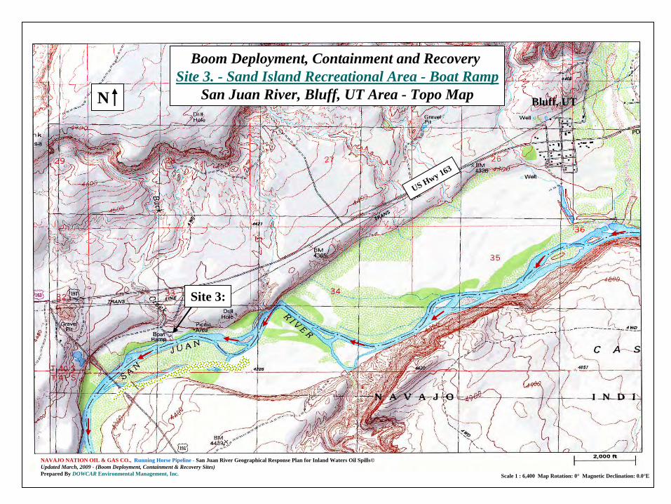
NAVAJO NATION OIL & GAS CO., Running Horse Pipeline - San Juan River Geographical Response Plan for Inland Waters Oil Spills©Updated March, 2009 -
(Boom Deployment, Containment & Recovery Sites)Prepared By DOWCAR Environmental Management, Inc. Scale 1 : 6,400 Map Rotation: 0° Magnetic Declination: 0.0°E
N
Boom Deployment, Containment and Recovery Site 3. -
Sand Island Recreational Area -
Boat RampSan Juan River, Bluff, UT Area -
Topo Map
Site 3:
US Hwy 163
Bluff, UT

NAVAJO NATION OIL & GAS CO., Running Horse Pipeline - San Juan River Geographical Response Plan for Inland Waters Oil Spills©Updated March, 2009 -
(Boom Deployment, Containment & Recovery Sites)Prepared By DOWCAR Environmental Management, Inc.
Boom Deployment, Containment and Recovery Site 3. -
Sand Island Recreational Area -
Boat RampSan Juan River, Bluff, UT Area -
Aerial Photo
River
Flow
River Flow
River Flow
N
Site 3: Primary
Boom Deployment
San Juan River Flow
US Hwy 163
San Juan River Flow
San Juan River Flow
San Juan River Flow
Sand Island Recreational Area

NAVAJO NATION OIL & GAS CO., Running Horse Pipeline - San Juan River Geographical Response Plan for Inland Waters Oil Spills©Updated March, 2009 -
(Boom Deployment, Containment & Recovery Sites)Prepared By DOWCAR Environmental Management, Inc. Scale 1 : 6,400 Map Rotation: 0° Magnetic Declination: 0.0°E
N
Boom Deployment, Containment and Recovery Site 3. -
Sand Island Recreational Area -
Boat RampSan Juan River, Bluff, UT Area -
Topo Map
Site 3:
US Hwy 163
Sand Island Recreational Area
Sand Island Recreational Area

NAVAJO NATION OIL & GAS CO., Running Horse Pipeline - San Juan River Geographical Response Plan for Inland Waters Oil Spills©Updated March, 2009 -
(Boom Deployment, Containment & Recovery Sites)Prepared By DOWCAR Environmental Management, Inc.
Boom Deployment, Containment and Recovery Site 3. -
Sand Island Recreational Area -
Boat RampSan Juan River, Bluff, UT Area -
Aerial Photo
River Flow
River Flow
N
Site 3: Primary
Boom Deployment
San Juan River Flow
San Juan River Flow
Sand Island Recreational Area

NAVAJO NATION OIL & GAS CO., Running Horse Pipeline – San Juan River Geographical Response Plan for Inland Waters Oil Spills©Updated March, 2009 -
(Boom Deployment, Containment & Recovery Sites)Prepared By DOWCAR Environmental Management, Inc.
GENERAL LOCATION:
Longitudes: N 37°
15.697’Latitude: W 109°
36.724’Elevation: 4,276 ft.River Width: 150 -
170 ft.Boom Required: 450 -
650 ft.Distance to RHPL Office: 19.08 miles
150 FT.
Gra
vel R
oad
AnchorsAnchors
Anchors
Anchors
Anchors
San Juan River Flow
Oil Spill Containment Boom4”x 6” (10”) w/Top Tension
@ 50 – 100 ft. Sections
N
Boom Deployment, Containment and Recovery Site 3. -
Sand Island Recreational Area -
Boat RampSan Juan River, Bluff, UT Area -
Response Strategy Drawing
Not to Scale
Secondary Boom Deployment
Primary Cascade Boom Deployment
Shoreline Protection Boom Deployment
Site 3:
Gravel RoadSand Island
Recreational Area
San Juan River Flow

NAVAJO NATION OIL & GAS CO., Running Horse Pipeline - San Juan River Geographical Response Plan for Inland Waters Oil Spills©Updated March, 2009 -
(Boom Deployment, Containment & Recovery Sites)Prepared By DOWCAR Environmental Management, Inc.
Boom Deployment, Containment and Recovery Site 3. -
Sand Island Recreational Area -
Boat RampSan Juan River, Bluff, UT Area -
Looking Up River Photo
N

NAVAJO NATION OIL & GAS CO., Running Horse Pipeline – San Juan River Geographical Response Plan for Inland Waters Oil Spills©Updated March, 2009 -
(Boom Deployment, Containment & Recovery Sites)Prepared By DOWCAR Environmental Management, Inc.
Boom Deployment, Containment and Recovery Site 3. -
Sand Island Recreational Area -
Boat RampSan Juan River, Bluff, UT Area -
Looking Up River Photo
Site 3: Primary Cascade
Boom Deployment
Site 3: Secondary
Boom Deployment
River Flow
N
Site 3: Shoreline Protection
Boom Deployment

TEST the SITES in the PLANPERMANENT ANCHORS for FASTER RESPONSE TIMES and MINIMAL ENVIRONMENTAL IMPACT
Boom Deployment, Containment and Recovery Exercise atSite 3. -
Sand Island Recreational Area -
Boat RampSan Juan River, Bluff, UT Area -
Looking Up River Photo

3.
TEST EACH PRE-DESIGNATED SITE LISTED in the
GEOGRAPHICAL RESPONSE PLAN (GRP)
to DETERMINE if
the SITE is VIABLE.
PERMANENT BOOM DEPLOYMENT ANCHORS for FASTER RESPONSE TIMES and MINIMAL ENVIRONMENTAL IMPACT
STEPS in PLACING PERMANENT ANCHORS: (cont.)
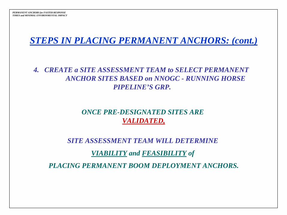
PERMANENT ANCHORS for FASTER RESPONSE TIMES and MINIMAL ENVIRONMENTAL IMPACT
STEPS IN PLACING PERMANENT ANCHORS: (cont.)
4. CREATE a SITE ASSESSMENT TEAM to SELECT PERMANENT ANCHOR SITES BASED on NNOGC -
RUNNING HORSE PIPELINE’S GRP.
ONCE PRE-DESIGNATED SITES ARE VALIDATED,
SITE ASSESSMENT TEAM WILL
DETERMINE
VIABILITY
and FEASIBILITY
of
PLACING PERMANENT BOOM DEPLOYMENT ANCHORS.

SITE ASSESSMENT TEAM is MADE UP of the FOLLOWING:
LAND SURVEYOR
NAVAJO NATION
ARCHEOLOGIST
NAVAJO NATION CULTURAL EXPERTS
NNOGC -
RUNNING HORSE PIPELINE PERSONNEL
DOWCAR Environmental Management, Inc. PERSONNEL
PERMANENT BOOM DEPLOYMENT ANCHORS for FASTER RESPONSE TIMES and MINIMAL ENVIRONMENTAL IMPACT

5.
CONDUCT a
SITE ASSESSMENT SURVEY
at EACH PRE-DESIGNATED SITE to
DETERMINE FEASIBILITY of
PLACING PERMANENT ANCHORS.
PERMANENT BOOM DEPLOYMENT ANCHORS for FASTER RESPONSE TIMES and MINIMAL ENVIRONMENTAL IMPACT
STEPS in PLACING PERMANENT ANCHORS: (cont.)

SITE ASSESSMENT SURVEY INCLUDES:
• DETERMINATION of OWNERSHIP of LAND -
BLM or Navajo Nation
• CULTURAL, HISTORICAL or ARCHEOLOGICAL ISSUES
• PORTION of LAND MAPPED to be UTILIZED
• LEGAL MAP for ANCHOR PLACEMENT POSITIONS for EACH SITE
• LOCATION of PERMANENT ANCHORS on BOTH SIDES of SAN JUAN RIVER
•TYPE of PERMANENT ANCHOR
PERMANENT ANCHORS for FASTER RESPONSE TIMES and MINIMAL ENVIRONMENTAL IMPACT
SITE ASESSMENT SURVEY INCLUDES: (cont.)
•
CONTENTS of PRESENTATION to NAVAJO NATION CHAPTER COUNCILS
•
APPROVALS from DEPARTMENT of INTERIOR –
BUREAU of LAND MANAGEMENT
•
PERMANENT ANCHOR LOCATIONS
•
EACH PERMANENT ANCHOR SITE to HAVE
° 1 to 2 Near Shore Anchors
° 2 to 3 Far Shore Anchors
PERMANENT ANCHORS for FASTER RESPONSE TIMES and MINIMAL ENVIRONMENTAL IMPACT
PERMANENT ANCHORS for FASTER RESPONSE TIMES and MINIMAL ENVIRONMENTAL IMPACT
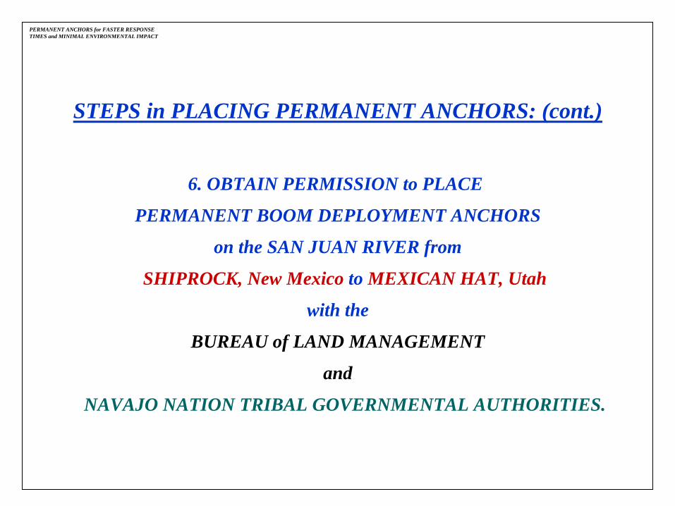
6. OBTAIN PERMISSION to PLACE
PERMANENT BOOM DEPLOYMENT ANCHORS
on the SAN JUAN RIVER from
SHIPROCK, New Mexico to
MEXICAN HAT, Utah
with the
BUREAU of LAND MANAGEMENT
and
NAVAJO NATION TRIBAL GOVERNMENTAL AUTHORITIES.
STEPS in PLACING PERMANENT ANCHORS: (cont.)
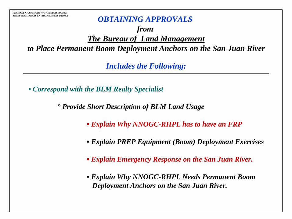
PERMANENT ANCHORS for FASTER RESPONSE TIMES and MINIMAL ENVIRONMENTAL IMPACT OBTAINING APPROVALS
fromThe Bureau of Land Management
to Place Permanent Boom Deployment Anchors on the San Juan River
Includes the Following:
•
Correspond with the BLM Realty Specialist
°
Provide Short Description of BLM Land Usage
▪
Explain Why NNOGC-RHPL has to have an FRP
▪
Explain PREP Equipment (Boom) Deployment Exercises
▪
Explain Emergency Response on the San Juan River.
▪
Explain Why NNOGC-RHPL Needs Permanent Boom Deployment Anchors on the San
Juan River.

PERMANENT ANCHORS for FASTER RESPONSE TIMES and MINIMAL ENVIRONMENTAL IMPACT
°
Provide Legal Map of Anchor Placement at Boom Deployment Sites
▪
Mexican Hat Boat Ramp, Mexican Hat, UT
▪
Bluff, South of UT Hwy 163 and CR 2451, Bluff, UT
▪
Sand Island Recreational Area, Bluff, UT
OBTAINING APPROVALSfrom
The Bureau of Land Managementto Place Permanent Boom Deployment Anchors on the San Juan River
Includes the Following: (cont.)

PERMANENT ANCHORS for FASTER RESPONSE TIMES and MINIMAL ENVIRONMENTAL IMPACT
OBTAINING APPROVALSfrom
The Bureau of Land Managementto Place Permanent Boom Deployment Anchors on the San Juan River
Includes the Following: (cont.)
•
BLM Visits Each Boom Deployment Site
•
BLM Provides Environmental Assessment
•
BLM Drafts Right to Use Permit for Each Site
•
NNOGC-RHPL Pays BLM Permitting Fee
•
BLM Issues Permit to Place Permanent Anchors
PERMANENT ANCHORS for FASTER RESPONSE TIMES and MINIMAL ENVIRONMENTAL IMPACT
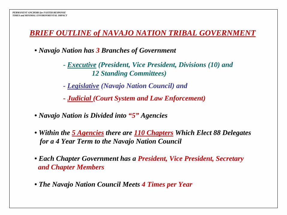
BRIEF OUTLINE of NAVAJO NATION TRIBAL GOVERNMENT
•
Navajo Nation has 3 Branches of Government
-
Executive
(President, Vice President, Divisions (10) and12 Standing Committees)
-
Legislative
(Navajo Nation Council) and
-
Judicial (Court System and Law Enforcement)
•
Navajo Nation is Divided into “5”
Agencies
•
Within the 5 Agencies
there are 110 Chapters
Which Elect 88 Delegates for a 4 Year Term to the Navajo Nation Council
•
Each Chapter Government has a President, Vice President, Secretary and Chapter Members
•
The Navajo Nation Council Meets 4 Times per Year

PERMANENT ANCHORS for FASTER RESPONSE TIMES and MINIMAL ENVIRONMENTAL IMPACT
Navajo Nation

PERMANENT ANCHORS for FASTER RESPONSE TIMES and MINIMAL ENVIRONMENTAL IMPACT 5 Navajo Nation Agencies

PERMANENT ANCHORS for FASTER RESPONSE TIMES and MINIMAL ENVIRONMENTAL IMPACT
Red MesaChapter
Aneth Chapter
SHIPROCK AGENCY
Navajo Nation Affected Chapters in Shiprock Agency
BLM LAND
CHINLE AGENCY
WE
STE
RN
AG
EN
CY
EA
STE
RN
AG
EN
CY
Teec Nos PosChapter
ShiprockChapter
Mexican Water
Chapter
AnethChapter

PERMANENT ANCHORS for FASTER RESPONSE TIMES and MINIMAL ENVIRONMENTAL IMPACT OBTAINING APPROVALS
fromThe NAVAJO NATION TRIBAL GOVERNMENT
to Place Permanent Boom Deployment Anchors on the San Juan River
Includes the Following:
•
Write a Supporting Resolutionand ask Permission to Place
Permanent Boom Deployment Anchors on Navajo Nation Tribal Lands.
°
Resolution had to be Approved by the Following Affected Chapters:
▪
Mexican Water
▪
Shiprock
▪
Red Mesa
▪
Aneth
▪
Teec Nos Pos

PERMANENT ANCHORS for FASTER RESPONSE TIMES and MINIMAL ENVIRONMENTAL IMPACT
°
Each Chapter had Initial Issues with NNOGC -
RHPL
▪
NNOGC-RHPL Attended Numerous Chapter Meetings
▪
Negotiated with Chapter Members on Community Support for Permanent Anchor Project
▪
NNOGC-RHPL Assured and Pledged to Chapter Members that the Company Would be an Excellent Environmental Citizen
OBTAINING APPROVALSfrom
The NAVAJO NATION TRIBAL GOVERNMENTto Place Permanent Boom Deployment Anchors on the San Juan River
Includes the Following: (cont.)

PERMANENT ANCHORS for FASTER RESPONSE TIMES and MINIMAL ENVIRONMENTAL IMPACT
OBTAINING APPROVALSfrom
The NAVAJO NATION TRIBAL GOVERNMENTto Place Permanent Boom Deployment Anchors on the San Juan River
Includes the Following: (cont.)
•
Provide the Following to Each Affected Chapter Site:
Legal Map
of Each Permanent Anchor Site
Environmental Assessment
for Each Location
Archeological Survey
for Each Location
•
Obtain Permission to Place Permanent Boom Deployment Anchors on San Juan River from Each Affected Chapter by Means of “Chapter Resolution”

PERMANENT ANCHORS for FASTER RESPONSE TIMES and MINIMAL ENVIRONMENTAL IMPACT
OBTAINING APPROVALSfrom
The NAVAJO NATION TRIBAL GOVERNMENTto Place Permanent Boom Deployment Anchors on the San Juan River
Includes the Following: (cont.)
•
Once the Chapter Resolutions are Completed,
• NNOGC-RHPL Submits a “Right of Way”
Proposal Package to the Navajo Nation Land Department for Approval.
•
“Right of Way”
Proposal Package Includes the Following for each site:
° A Legal Map
°
Environmental Assessments
°
Archeological Survey
°
The Approved Chapter Resolutions

PERMANENT ANCHORS for FASTER RESPONSE TIMES and MINIMAL ENVIRONMENTAL IMPACT OBTAINING APPROVALS
fromThe NAVAJO NATION TRIBAL GOVERNMENT
to Place Permanent Boom Deployment Anchors on the San Juan River
Includes the Following: (cont.)
•
Upon
Approval,the Navajo Nation Land Department
Submits
the “Right of Way”
Proposal
Package
to Various Navajo Nation Entities for Review and Approval:
°
Navajo Nation Division of Natural Resouces
°
BIA Agency Realty Office
°
Navajo Land Division “Right-of-Way”
Specialist

PERMANENT ANCHORS for FASTER RESPONSE TIMES and MINIMAL ENVIRONMENTAL IMPACT OBTAINING APPROVALS
fromThe NAVAJO NATION TRIBAL GOVERNMENT
to Place Permanent Boom Deployment Anchors on the San Juan River
Includes the Following: (cont.)
•
Upon Approval from the Navajo Nation Governmental Entities and the BIA,the “Right-of-Way”
Proposal Package is submitted to the Chair Person
of the Resource Committee of the Navajo Nation Division of Natural Resources.
•
Once the ROW Project for Permanent Anchors on Navajo Nation Tribal Lands is Approved by the Navajo Nation Council, the Resource Committee Approves
the ROW Project.
°
ROW Project Package is Submitted to the Navajo Nation Presidentfor Approval and is Approved.
°
The ROW Project Package is Submitted to the BIA Agency Realty Office for Final Review and Approval.
°
The Permanent Boom Deployment Anchor Project is APPROVED.

PERMANENT ANCHORS for FASTER RESPONSE TIMES and MINIMAL ENVIRONMENTAL IMPACT
OBTAINING APPROVALSfrom
The NAVAJO NATION TRIBAL GOVERNMENTto Place Permanent Boom Deployment Anchors on the San Juan River
Includes the Following: (cont.)
•
ROW Permit is Issued to NNOGC-RHPL
to Position Permanent Boom Deployment Anchors on the San Juan River at the following Pre-designatedSites:
°
Site 1. -
Mexican Hat Boat Ramp
°
Site 3. -
Sand Island Recreational Area
°
Site 4. -
Bluff, Intersection of UT Hwy 163 and CR 2451
°
Site 5. -
Montezuma Creek Water Tower
°
Site 7. -
Aneth Community School
°
Site 9 -
Shiprock Gaging Station

PERMANENT ANCHORS for FASTER RESPONSE TIMES and MINIMAL ENVIRONMENTAL IMPACT
COST to COMPLETEPERMANENT BOOM DEPLOYMENT ANCHORS
on the SAN JUAN RIVER_________________________________________________________________
NNOGC-RHPL $ 5,000.00
DOWCAR
5,000.00
BLM Permitting Fee
1,600.00
Land Surveyor
1,500.00
Environmental Assessments
14,000.00
Archeological Survey
7,500.00
Navajo Nation ROW Fee
20,000.00
TOTAL COST:
$57,600.00

PERMANENT ANCHORS for FASTER RESPONSE TIMES and MINIMAL ENVIRONMENTAL IMPACT
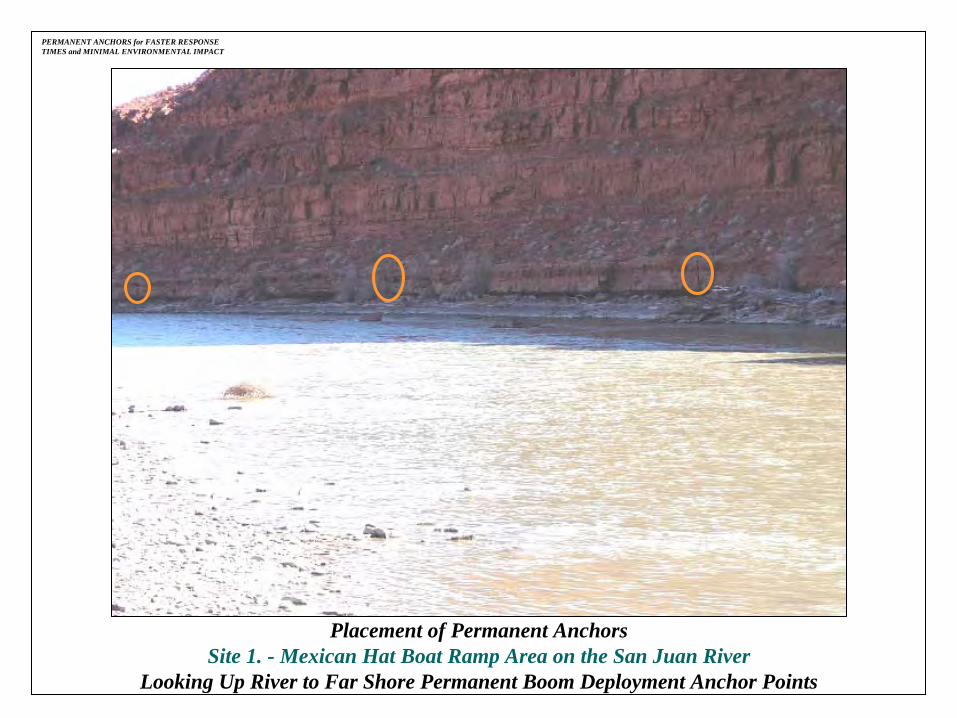
Placement of Permanent AnchorsSite 1. -
Mexican Hat Boat Ramp Area on the San Juan RiverLooking Up River to Permanent Anchors Designed to Blend into Landscape Environment
PERMANENT ANCHORS for FASTER RESPONSE TIMES and MINIMAL ENVIRONMENTAL IMPACT
Placement of Permanent AnchorsSite 1. -
Mexican Hat Boat Ramp Area on the San Juan RiverLooking Up River to Far Shore Permanent Boom Deployment Anchor Points

PERMANENT ANCHORS for FASTER RESPONSE TIMES and MINIMAL ENVIRONMENTAL IMPACT
Placement of Permanent AnchorsSite 1. -
Mexican Hat Boat Ramp Area on the San Juan RiverLooking Up River to Far Shore Permanent Boom Deployment Anchor

PERMANENT ANCHORS for FASTER RESPONSE TIMES and MINIMAL ENVIRONMENTAL IMPACT
Placement of Permanent AnchorsSite 1. -
Mexican Hat Boat Ramp Area on the San Juan RiverLooking Down River to Permanent Boom Deployment Anchor Containment and Recovery Point
PERMANENT ANCHORS for FASTER RESPONSE TIMES and MINIMAL ENVIRONMENTAL IMPACT
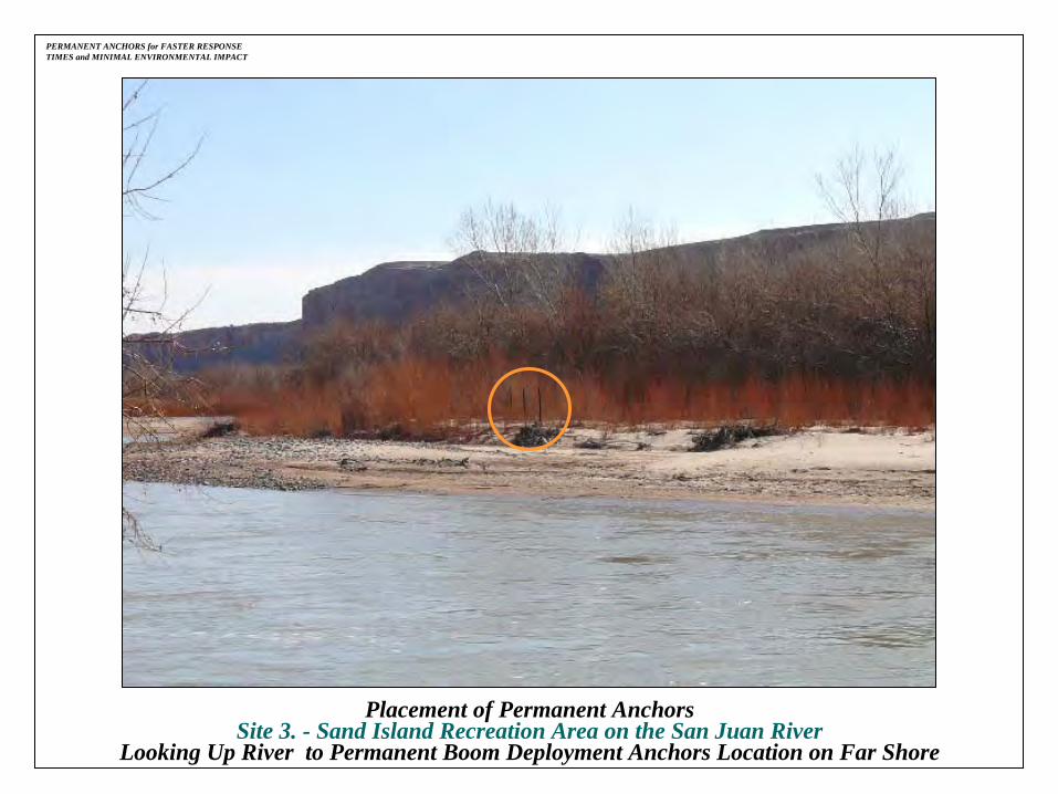
Placement of Permanent AnchorsSite 3. -
Sand Island Recreation Area on the San Juan RiverLooking Up River to Permanent Boom Deployment Anchors Location on Far Shore

PERMANENT ANCHORS for FASTER RESPONSE TIMES and MINIMAL ENVIRONMENTAL IMPACT
Placement of Permanent AnchorsSite 3. -
Sand Island Recreation Area on the San Juan RiverLooking Up River to Permanent Boom Deployment Anchors Location on Far Shore

PERMANENT ANCHORS for FASTER RESPONSE TIMES and MINIMAL ENVIRONMENTAL IMPACT
PREP Annual Equipment Deployment Exercise Utilizing Permanent Boom Deployment AnchorsSite 3. -
Sand Island Recreation AreaUp River Far Side Permanent Boom Deployment Anchors

PERMANENT ANCHORS for FASTER RESPONSE TIMES and MINIMAL ENVIRONMENTAL IMPACT
PREP Annual Equipment Deployment Exercise Utilizing Permanent Boom Deployment AnchorsSite 3. -
Sand Island Recreation AreaLooking Up River

PERMANENT ANCHORS for FASTER RESPONSE TIMES and MINIMAL ENVIRONMENTAL IMPACT
PREP Annual Equipment Deployment Exercise Utilizing Permanent AnchorsSite 3. -
Sand Island Recreation AreaLooking Up River with Boom and Oleophilic Drum Skimmer Deployed

PERMANENT ANCHORS for FASTER RESPONSE TIMES and MINIMAL ENVIRONMENTAL IMPACT
Placement of Permanent AnchorsSite 4. -
Bluff, South of UT 163 at CR 2451Area on the San Juan River Looking Up RiverLooking Up River from Near Shore Containment and Recovery Anchor
Points
Cleared Far Shore Bank with 3 Permanent Anchors

PERMANENT ANCHORS for FASTER RESPONSE TIMES and MINIMAL ENVIRONMENTAL IMPACT
Cleared Far Shore Bank with 3 Anchors
Placement of Permanent AnchorsSite 4. -
Bluff, South of UT 163 at CR 2451Area on the San Juan River Looking Up RiverLooking Up River from Near Shore Containment and Recovery Anchor
Points
Cleared Far Shore Bank with 3 Permanent Anchors

PERMANENT ANCHORS for FASTER RESPONSE TIMES and MINIMAL ENVIRONMENTAL IMPACT
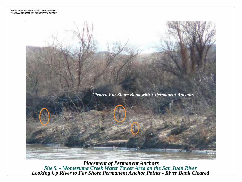
Placement of Permanent AnchorsSite 5. -
Montezuma Creek Water Tower Area on the San Juan River Looking Up River from Near Shore Containment and Recovery Anchor
Points
Cleared Far Shore Bank with 3 Anchors

PERMANENT ANCHORS for FASTER RESPONSE TIMES and MINIMAL ENVIRONMENTAL IMPACT
Placement of Permanent AnchorsSite 5. -
Montezuma Creek Water Tower Area on the San Juan River Looking Up River to Far Shore Permanent Anchor Points -
River Bank Cleared
Cleared Far Shore Bank with 3 Permanent Anchors
PERMANENT ANCHORS for FASTER RESPONSE TIMES and MINIMAL ENVIRONMENTAL IMPACT
Placement of Permanent AnchorsSite 5. -
Montezuma Creek Water Tower Area on the San Juan River Looking Up River to Far Shore Permanent Anchor Points -
River Bank Cleared
Cleared Far Shore Bank with 3 Permanent Anchors

PERMANENT ANCHORS for FASTER RESPONSE TIMES and MINIMAL ENVIRONMENTAL IMPACT
PREP Annual Equipment Deployment ExerciseSite 7. -
Aneth Community School Area on the San Juan RiverTesting of Predesignated Boom Deployment Site for Permanent Boom
Deployment Anchors
PERMANENT ANCHORS for FASTER RESPONSE TIMES and MINIMAL ENVIRONMENTAL IMPACT
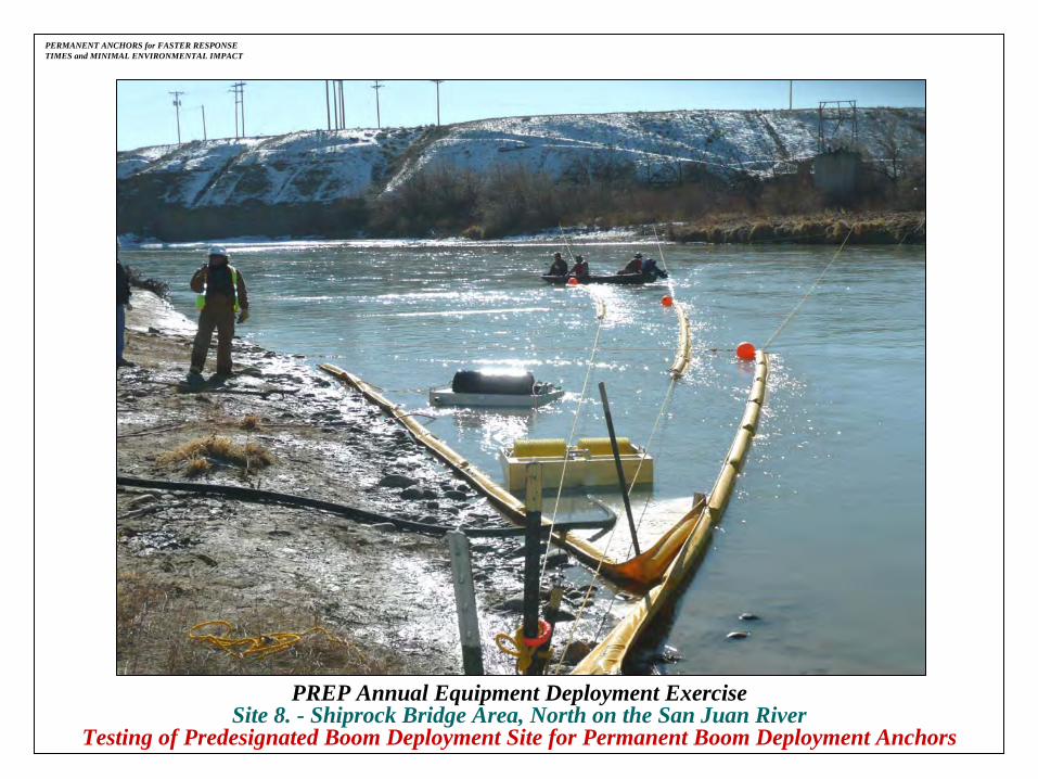
PREP Annual Equipment Deployment ExerciseSite 8. -
Shiprock Bridge Area, North on the San Juan RiverTesting of Predesignated Boom Deployment Site for Permanent Boom
Deployment Anchors

PERMANENT BOOM DEPLOYMENT ANCHORS CAN be FOUND in the FOLLOWING RIVERS:
Weber River -
Coalville, Utah
Marias River -
Shelby, Montana
Missouri River -
Great Falls, Montana
North Platte River -
Casper and Torrington, Wyoming
Nonconnah
Creek -
Memphis, Tennessee
PERMANENT ANCHORS for FASTER RESPONSE TIMES and MINIMAL ENVIRONMENTAL IMPACT

PERMANENT ANCHORS for FASTER RESPONSE TIMES and MINIMAL ENVIRONMENTAL IMPACT
Permanent Boom Deployment AnchorsWeber River -
Coalville, UT Area

PERMANENT ANCHORS for FASTER RESPONSE TIMES and MINIMAL ENVIRONMENTAL IMPACT
Permanent Boom Deployment AnchorsWeber River -
Coalville, UT Area

PERMANENT ANCHORS for FASTER RESPONSE TIMES and MINIMAL ENVIRONMENTAL IMPACT
Using Permanent Anchors Marias River -
Shelby, Montana

PERMANENT ANCHORS for FASTER RESPONSE TIMES and MINIMAL ENVIRONMENTAL IMPACT
Using Permanent Anchors on the Marias River -
Near Shore Containment and Recovery Pointin the Shelby, Montana Area

PERMANENT ANCHORS for FASTER RESPONSE TIMES and MINIMAL ENVIRONMENTAL IMPACT
Using Permanent Anchors on the Marias River -
Looking Up River to Far Shore Anchor Boom Tie Down Points in the Shelby, Montana Area

PERMANENT ANCHORS for FASTER RESPONSE TIMES and MINIMAL ENVIRONMENTAL IMPACT
Using Permanent Anchors on the Missouri River -
Looking Up River to Buoy Anchor Pointsin the Great Falls, Montana Area

PERMANENT ANCHORS for FASTER RESPONSE TIMES and MINIMAL ENVIRONMENTAL IMPACT
Using Permanent Anchors on the Missouri River -
600 lb. Containment and Recovery Point in the Great Falls, Montana Area

PERMANENT ANCHORS for FASTER RESPONSE TIMES and MINIMAL ENVIRONMENTAL IMPACT
Using Permanent Anchors on the Missouri River -
600 lb. Containment and Recovery Point Near Giant Springs in the Great Falls, Montana Area

PERMANENT ANCHORS for FASTER RESPONSE TIMES and MINIMAL ENVIRONMENTAL IMPACT
Using Permanent Anchors on the North Platte River -
Looking Up River to Far Shore Boom Anchor Tie Down Points
in the Torrington, Wyoming Area
PERMANENT ANCHORS for FASTER RESPONSE TIMES and MINIMAL ENVIRONMENTAL IMPACT
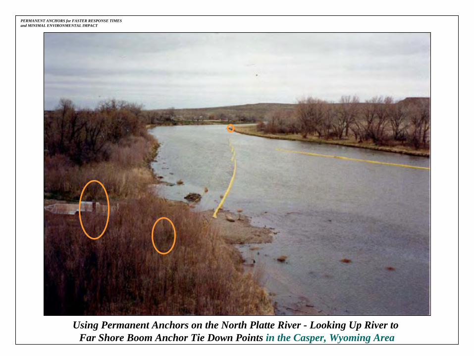
Using Permanent Anchors on the North Platte River -
Looking Up River to Far Shore Boom Anchor Tie Down Points in the Casper, Wyoming Area

PERMANENT ANCHORS for FASTER RESPONSE TIMES and MINIMAL ENVIRONMENTAL IMPACT
Using Permanent Anchors on the Nonconnah
Creek -Looking Up to Far Shore Boom Anchor Tie Down Points
in the Memphis, Tennessee Area

PERMANENT ANCHORS for FASTER RESPONSE TIMES and MINIMAL ENVIRONMENTAL IMPACT
Using Permanent Buoy Anchors on the Colorado -
Looking Up River to Buoy Anchor Tie Down Points
in the Lee’s Ferry, Glen Canyon National Recreational Area, Arizona

BENEFITS of PERMANENT ANCHORS:
•
QUICKER RESPONSE TIMES.
•
LESS MANPOWER NEEDED.
Five Out of Six
Permanent Boom Deployment Anchor Sites on the
San Juan River from Mexican Hat, UT to Shiprock, NMare Completed.
REMAINDER SCHEDULED for 2009
PERMANENT ANCHORS for FASTER RESPONSE TIMES and MINIMAL ENVIRONMENTAL IMPACT

PERMANENT ANCHORS for FASTER RESPONSE TIMES and MINIMAL ENVIRONMENTAL IMPACT
PREP Annual Equipment Deployment Exercise
Utilizing Permanent Boom Deployment Anchors
Site 3. -
Sand Island Recreation Area

PERMANENT BOOM DEPLOYMENT ANCHORS CAN HELP PREVENT THIS
PERMANENT ANCHORS for FASTER RESPONSE TIMES and MINIMAL ENVIRONMENTAL IMPACT