PERFORMANCE SPECIFICATION DIGITAL … METRIC MIL-PRF-89020B 23 May 2000 SUPERSEDING MIL-PRF-89020A...
45
MIL-PRF-89020B METRIC MIL-PRF-89020B 23 May 2000 SUPERSEDING MIL-PRF-89020A 19 April 1996 PERFORMANCE SPECIFICATION DIGITAL TERRAIN ELEVATION DATA (DTED) This specification is approved for use by all Departments and Agencies of the Department of Defense. 1. SCOPE 1.1 Scope. This specification defines the requirements within National Imagery and Mapping Agency’s (NIMA) Digital Terrain Elevation Data Base which supports various weapon and training systems. This edition includes the Shuttle Radar Topography Mission (SRTM) DTED Level 1 and Level 2 requirements. 1.2 Purpose. The purpose of this specification is to assure uniformity of treatment among all mapping and charting elements engaged in a coordinated production and maintenance program for this product. 1.3 Classification. Digital Terrain Elevation Data (DTED) is produced at three different levels of detail. The three classes of DTED are known as DTED Level 0, DTED Level 1; and DTED Level 2. 2. APPLICABLE DOCUMENTS 2.1 General. The documents listed in this section are needed to meet the requirements specified in sections 3, 4, and 5 of this specification. This section does not include documents cited in other sections of this specification or recommended for additional information as examples. While every effort has been made to ensure the completeness of this list, document users are cautioned that they must meet all requirements documents cited in sections 3, 4, and 5 of this specification, whether or not they are listed. Beneficial comments (recommendations, additions, deletions) and any pertinent data which may be of use in improving this document should be addressed to: Director, National Imagery and Mapping Agency, ATTN: Doctrine and Force Development/DF (P-37), 12310 Sunrise Valley Drive, Reston, Va. 20191-3449, by using the Standardization Document Improvement Proposal (DD Form 1426) appearing at the end of this document or by letter. AMSC N/A AREA MCGT DISTRIBUTION STATEMENT A. Approved for public release; distribution is unlimited.
Transcript of PERFORMANCE SPECIFICATION DIGITAL … METRIC MIL-PRF-89020B 23 May 2000 SUPERSEDING MIL-PRF-89020A...

MIL-PRF-89020B
METRICMIL-PRF-89020B
23 May 2000SUPERSEDING
MIL-PRF-89020A19 April 1996
PERFORMANCE SPECIFICATIONDIGITAL TERRAIN ELEVATION DATA (DTED)
This specification is approved for use by allDepartments and Agencies of the Department of Defense.
1. SCOPE
1.1 Scope. This specification defines the requirements withinNational Imagery and Mapping Agency’s (NIMA) Digital Terrain Elevation DataBase which supports various weapon and training systems. This editionincludes the Shuttle Radar Topography Mission (SRTM) DTED Level 1 and Level 2requirements.
1.2 Purpose. The purpose of this specification is to assureuniformity of treatment among all mapping and charting elements engaged in acoordinated production and maintenance program for this product.
1.3 Classification. Digital Terrain Elevation Data (DTED) is producedat three different levels of detail. The three classes of DTED are known asDTED Level 0, DTED Level 1; and DTED Level 2.
2. APPLICABLE DOCUMENTS
2.1 General. The documents listed in this section are needed to meetthe requirements specified in sections 3, 4, and 5 of this specification.This section does not include documents cited in other sections of thisspecification or recommended for additional information as examples. Whileevery effort has been made to ensure the completeness of this list, documentusers are cautioned that they must meet all requirements documents cited insections 3, 4, and 5 of this specification, whether or not they are listed.
Beneficial comments (recommendations, additions, deletions) and any pertinentdata which may be of use in improving this document should be addressed to:Director, National Imagery and Mapping Agency, ATTN: Doctrine and ForceDevelopment/DF (P-37), 12310 Sunrise Valley Drive, Reston, Va. 20191-3449, byusing the Standardization Document Improvement Proposal (DD Form 1426)appearing at the end of this document or by letter.AMSC N/A AREA MCGT
DISTRIBUTION STATEMENT A. Approved for public release; distribution isunlimited.

MIL-PRF-89020B
2
2.2 Government documents.
2.2.1 Specifications, standards, and handbooks . The followingspecifications, standards, and handbooks form a part of this document to theextent specified herein. Unless otherwise specified, the issues of thesedocuments are those listed in the current Department of Defense Index ofSpecifications and Standards (DODISS) and supplement thereto, cited in thesolicitation (see 6.2).
STANDARDS
FEDERAL INFORMATION PROCESSING STANDARDS
FIPS 10-4 Countries. Dependencies. AreasOf Special Sovereignty, andTheir Principal AdministrativeDivisions
DEPARTMENT OF DEFENSE
MIL-STD-600001 - MC&G Accuracy Standard
HANDBOOKS
DEPARTMENT OF DEFENSE
MIL-HDBK-9660 - DoD Produced CD-ROM Products
(Unless otherwise indicated, copies of federal and military specifications,standards, and handbooks are available from the DoD Single Stock Point(DODSSP), 700 Robbins Avenue, Building 4D, Philadelphia, PA 19111-5094.Copies of Federal Information Processing Standards (FIPS) are available toDepartment of Defense activities from the DoD Single Stock Point (DODSSP).Others must request copies from the National Information Services, 5285 PortRoyal Road, Springfield, VA 22161-2171.)
2.2.2 Other Government documents, drawings, and publications . Thefollowing other Government documents, drawings, and publications form a partof this document to the extent specified herein. Unless otherwise specified,the issues are those cited in the solicitation.
a. NIMA TR 8350.2, Third Edition, 4 July 1997, Department ofDefense World Geodetic System 1984, It's Definition and Relationships withLocal Geodetic Systems.
b. NIMA Instruction 8955.1, Guidelines for Labeling The NationalImagery and Mapping Agency's CD-ROMs, and Printing and Finishing of Jewel CaseLiners/Cardboard Sleeves, and Information Booklets.
c. NIMA Instruction 5200.1, Information Security, 8 May 1998.
d. NIMA Instruction 5220.1, Industrial Security, 10 February1999.
(Copies of the above publication are availa ble from the NationalImagery and Mapping Agency, Interoperability Standards Division (SES), MailStop P-24, 12310 Sunrise Valley Drive, Reston, VA 20191-3449.)

MIL-PRF-89020B
3
e. DMA INST 8660.10, Procedures for Request, Release, Handling,and Distribution of Defense Mapping Agency (DMA) Mapping, Charting, andGeodesy (MC&G) Digital Products(U), 10 April 1990.
(Copies of legacy policies can be requested from the NationalImagery and Mapping Agency, National Imagery and Geospatial Policy Office(NP), Customer Service Division at (301) 227-7477, DSN 287-7477.)
2.3 Non-Government publications. The following document(s) form apart of this document to the extent specified herein. Unless otherwise speci-fied, the issues of the documents which are DoD adopted are those listed inthe issue of the DODISS cited in the solicitation. Unless otherwise speci-fied, the issues of documents not listed in the DODISS are the issues of thedocuments cited in the solicitation (See 6.2).
a. ANSI X3.27-1978, American National Sta ndard Magnetic TapeLabels for Information Interchange.
b. International Standard Organization (ISO) 9660: InternationalStandard. Information Processing - Volume and File Structure of CD-ROM forInformation Interchange. First Edition, 1988.
(Application for copies should be addressed to American National StandardsInstitute, Inc., 1430 Broadway, New York, NY 10018).
c. Phillips/Sony Red Book Specifications.
d. Phillips/Sony Yellow Book Specifications.
(Application for copies should be addressed to the Sony Corporation ofAmerica, 5001 Forbes Boulevard, Lanham, MD, 20706).
(Non-Government standards and other publications are normally available fromthe organizations that prepare or distribute the documents. These documentsalso may be available in or through libraries or other informationalservices.)
2.4 Order of precedence. In the event of a conflict between the textof this document and the references cited herein the text of this documenttakes precedence. Nothing in this document, however, supersedes applicablelaws and regulations unless a specific exemption has been obtained.
3. REQUIREMENTS
3.1 First article. When specified (see 6.2), a sample shall besubjected to first article inspection in accordance with 4.2.
3.2 Datum.
3.2.1 Horizontal datum. Horizontal Datum shall be the World GeodeticSystem (WGS 84). DTED shall be compiled to the current WGS datum or revisedto be compatible with the current WGS datum.
3.2.2 Vertical datum. Vertical Datum shall be Mean Sea Level (MSL) asdetermined by the Earth Gravitational Model (EGM) 1996.
3.3 Accuracy. Individual DTED cells have an accuracy calculated basedon collection and production methods and stored in the ACC record. Theindividual calculated DTED cell accuracies are usually better than those citedbelow.

MIL-PRF-89020B
4
3.3.1 DTED Level 1 accuracy.
3.3.1.1 Absolute accuracy.
3.3.1.1.1 Absolute horizontal accuracy.
90% Circular Error (C.E.) World Geodetic System (WGS) < 50 meters
3.3.1.1.2 Absolute vertical accuracy.
90% Linear Error (L.E.) Mean Sea Level (MSL) ≤ 30 meters
3.3.1.2 Relative vertical accuracy (point-to-point) .
90% L.E. MSL ≤20 meters over a 1° cell
3.3.2 DTED Level 2 accuracy.
3.3.2.1 Absolute accuracy.
3.3.2.1.1 Absolute horizontal accuracy.
90% Circular Error (C.E.) World Geodetic System (WGS) ≤ 23 meters
3.3.2.1.2 Absolute vertical accuracy.
90% Linear Error (L.E.) Mean Sea Level (MSL) ≤ 18 meters
3.3.2.2 Relative vertical accuracy (point-to-point) .
90% L.E. MSL ≤ 12 meters over a 1° cell for low and mediumrelief terrain (0 to 20% predominant slope).
90% L.E. MSL ≤ 15 meters over a 1° cell for high relief terrain(greater than 20% predominant slope).
3.4 Security.
3.4.1 Security Classification. The security classification of theproducts generated by the use of these specifications will be the lowestpracticable. When it is necessary to assign a security classification to theproduct, it shall be in accordance with established national securityprocedures.
This specification is unclassified, but its resultant products can be upto SECRET.
3.5 Product description.
3.5.1 One-degree cell. A data file of DTED Level 0, DTED Level 1 orDTED Level 2 is a 1° by 1° cell defined by whole degree latitude and longitudelines on WGS. A DTED file shall not cross whole degree latitude or longitudelines.
3.5.2 Adjacent one-degree data files. Adjacent one-degree data filesshall not have gaps between them and the only overlap that exists is alongadjacent boundaries. All adjacent boundaries shall be coincident.

MIL-PRF-89020B
5
3.5.3 DTED Surface characteristics.
3.5.3.1 Water
3.5.3.1.1 Flattened water bodies. Elevation values within a lake witha diameter equal to or greater than 1200 meters for DTED Level 1 or with adiameter equal to or greater than 600 meters for DTED Level 2 must beidentical. Sea or ocean elevation values for DTED Level 1 or DTED Level 2shall be zero.
3.5.3.1.2 Double-line drains. Drains with a width equal to or greaterthan 183 meters shall be visible in the DTED data.
3.5.3.2 Land.
3.5.3.2.1 Shorelines and coastlines. The land elevation values shallbe higher than the adjacent water elevations. Extremely shallow land justinterior to coastlines shall have + 1 meter elevation to force proper landboundary portrayal.
3.5.3.2.2 Islands. Islands with the major axis equal to or greaterthan 600 meters for DTED Level 1 or 300 meters for DTED Level 2 shall beincluded in the DTED data. Smaller islands shall be included in the DTED dataif the relief is equal to or greater than 15 meters above the water level.
3.5.3.3 Below mean sea level. All land or water bodies below mean sealevel shall have negative elevations.
3.5.4 DTED Level 0. A data file of DTED Level 0 is produced from DTEDLevel 1 or VMAP 0. The DTED Level 0 accuracy record is copied from the DTEDLevel 1 accuracy record or will contain NA (Not Available) when produced fromVMAP 0. DTED Level 0 is produced with only full one-degree cells with novoids. DTED Level 0 downloaded from the NIMA Gateway does not contain nullelevations.
3.5.5 DTED Level 1. DTED Level 1 CD-ROMs are produced with only fullone-degree cells with no voids. Only DTED Level 1 full one-degree cells withno voids can be downloaded from the NIMA Gateway.
3.5.6 DTED Level 2. DTED Level 2 CD-ROMs are produced with partial one-degree cells with voids. DTED Level 2 partial one-degree cells with voids canbe downloaded from the NIMA Gateway. DTED Level 2 partial cells will containnull elevations.
3.6 Standard format. NIMA has two methods of recording terrainelevation data depending on the recording media. One method is available onCompact Disc-Read Only Memory (CD-ROM) and from the NIMA Gateway. Theoriginal Standard Terrain Format is still available on 8mm tape or and nine(9)track magnetic tape.
3.6.1 Physical characteristics of CD-ROM.
3.6.1.1 CD-ROM characteristics. The physical characteristics of thecompact disc media are specified by the Philips/Sony Red Book. The digitaldata recording characteristics of the CD-ROM are specified by the Philips/SonyYellow book. Logical formatting, file directory structure, and labeling ofMC&G data on CD-ROM conforms to International Standards Organization (ISO)9660, level 1.
3.6.2 Physical characteristics of magnetic tape .

MIL-PRF-89020B
6
3.6.2.1 Nine (9) Track Tape. The physical characteristics of Nine (9)track magnetic tape are as follows:
a. Length: 2400 feet (maximum).
b. Width: .5 inch.
c. Nine track recording format.
d. Odd parity.
e. Inter-record gap: .6 inch for 1600 bits per inch (BPI) Tapes;.3 inch for 6250 BPI Tapes.
f. Physical end-of-tape markers at the beginning (beginning-of-tape marker) and end of the tape (end-of-tape marker).
g. Density-recording methods.
(1) 1600 BPI/Phase encoded.
(2) 6250 BPI/Group Coded Recording (GCR). Preferred NIMAdata exchange format (shall not be used unless agreed to by sender andreceiver).
3.6.2.2 Eight millimeter (8mm) Tape. The physical characteristicsof Eight millimeter (8mm) magnetic tape cartridges are as follows:
a. Length: 112 meters (maximum).
b. Width: 8 mm.
c. Helical recording format.
d. Physical end-of-tape markers at the beginning (beginning-of-tape marker) and end of the tape (end-of-tape marker).
e. Density-recording methods. 5, 7, 10, 14 GB per datacartridge.
3.6.3 Type of Input/Output (I/O). The individual records contain nosystem dependent generated control words.
3.7 Record characteristics on Magnetic Tape .
3.7.1 Recorded labels. American National Standard Magnetic Tape Labelsfor Information Interchange X3.27-1978. Recorded in ASCII code.
3.7.2 Data records.
a. Record size. Variable length, maximum 7214 bytes, minimum 14bytes, modal (average) 2414 bytes.
b. Blocking factor. 1:1 (block size = record size).

MIL-PRF-89020B
7
c. Record sequence.
VOL 1 (Volume Header Label)HDR 1 (Header Label for file A)UHL 1 (User Header Label for file A)*DSI (Data Set Identification Record for file A)ACC (Accuracy Description Record for file A)DATA (for file A)*EOF 1 (End of File for file A)UTL 1 (User Trailer Label for file A)*HDR 1 (Header Label for file B)UHL 1 (User Header Label for file B)*DSI (Data Set Identification Record for file B)ACC (Accuracy Description Record for file B)DATA (for file B)*EOF 1 (End of File for file B)UTL 1 (User Trailer Label for file B)**
Note: In the above sequence a Tape Mark (hardware end of file) i sdenoted by an “*”.
3.8 NIMA Gateway. Digital Terrain Elevation Data can be accessedthrough the NIMA Gateway via the World-Wide-Web (WWW), the Open SourceInformation System (OSIS), Secure Internet Protocol Router Network (SIPRNET)or the Joint Worldwide Intelligence Communication System (JWICS). DTED Level0 can be downloaded from the WWW, OSIS, SIPRNET and JWICS. DTED Level 1 andLevel 2 can be downloaded from the OSIS, SIPRNET and JWICS. The DTED filesare encapsulated and compressed into one file for downloading. Detailedinstructions for downloading and decompression are available on the webpages.
3.9 DTED File descriptions on CD-ROM or from the Gateway . The threeclasses of DTED are known as DTED Level 0, DTED Level 1, and DTED Level 2.Each DTED class consists of a different set of files.
DTED File Types
DTED Level 0consists of six filetypes. onc.dir <xxx>.dt0 <xxx>.avg <xxx>.min <xxx>.max dmed.
DTED Level 1 consistsof eight file types. onc.dir <xxx>.dt1 Read.me dmed. gazetteer directory
<country>.gaz<country>.hshGazette.dirGazette.key
DTED Level 2 consistsof four file types. onc.dir <xxx>.dt2 Read.me dmed.

MIL-PRF-89020B
3.9.1 The onc.dir file. An ASCII file named ONC.DIR provides, via ONCtiles, a directory to the DTED cells on the CD-ROM or when downloaded from theNIMA Gateway.
3.9.2 The <xxx>.dt0, .dt1, .dt2 files. The .dt0, .dt1, and .dt2 arethe terrain elevation data files for DTED Level 0, DTED Level 1 and DTED Level2, respectively. A data file of DTED is a cell defined by latitudes andlongitudes of a geographic reference system. The terrain elevationinformation is expressed in meters. The locations of elevation posts aredefined by the intersections of rows and columns within a matrix. Therequired matrix intervals, defined in terms of geographic arc seconds, varyaccording to latitude (see TABLE I for DTED Level 0, TABLE II for DTED Level 1and TABLE III for DTED Level 2). Each terrain elevation data file consists ofthe User Header Label(UHL), Data Set Identification(DSI) Record, AccuracyDescription Record(ACC) and the Data records. (See 3.12 for details of theterrain elevation data files.)
Note: In the tables below, all values in seconds are in terms of arcmeasure.
TABLE I. Matrix intervals for DTED Level 0.
ZONE LATITUDE MATRIX INTERVAL
latitude longitude
I 0° - 50° North-South 30 x 30 secondsII 50° - 70° North-South 30 x 60 seconds
III 70° - 75° North-South 30 x 90 secondsIV 75° - 80° North-South 30 x 120 secondsV 80° - 90° North-South 30 x 180 seconds
TABLE II. Matrix intervals for DTED Level 1.
ZONE LATITUDE MATRIX INTERVAL
latitude longitude
I 0° - 50° North-South 3 x 3 secondsII 50° - 70° North-South 3 x 6 seconds
III 70° - 75° North-South 3 x 9 secondsIV 75° - 80° North-South 3 x 12 secondsV 80° - 90° North-South 3 x 18 seconds
TABLE III. Matrix intervals for DTED Level 2.
ZONE LATITUDE MATRIX INTERVAL
latitude longitude
I 0° - 50° North-South 1 x 1 secondsII 50° - 70° North-South 1 x 2 seconds
III 70° - 75° North-South 1 x 3 secondsIV 75° - 80° North-South 1 x 4 secondsV 80° - 90° North-South 1 x 6 seconds

MIL-PRF-89020B
9
3.9.3 The <xxx>.avg, .min, .max files. The .avg, .min and .max datafiles are unique to DTED Level 0. They contain the average, minimum andmaximum terrain elevation value associated with each DTED Level 0 elevationvalue. The average, minimum and maximum values are calculated from DTEDLevel 1. Each 30" x 30" area of DTED1 (11 posts x 11 posts) are searched forthe minimum and maximum value; while the average is calculated from the 121values. Notice therefore that the row and columns of posts that divide each30"x 30" area are included in the calculations for two of the values. The.avg, .min, and .max files are composed of a Motorola (i.e., SUN) Format two(2) byte integer structure. Each data file consists of the User HeaderLabel(UHL), Data Set Identification(DSI) Record, Accuracy DescriptionRecord(ACC) and the Data records. The .avg, .min, and .max files arereferenced by the subcell's center coordinate pair. A subcell of DTED Level 0is defined as equal to thirty (30") arc second by thirty (30") arc second.The latitude spacing will always be consistent based upon the DTED level ofthe data, whereas the longitude spacing is dependent upon the level of thedata and geographic zone (See Table I). This file shall not cross wholedegree latitude and longitude lines.
3.9.4 The Read.me file. An ASCII text file named Read.me contains adescription of the disc contents including the geographic limits of thecompact disc, a count of the cells, a location diagram (text array) showingwhich cells in the minimum bounding rectangle are resident on the disc, and auser’s guide.
3.9.5 The DMED. file. The Digital Mean Elevation Data (DMED) file is anASCII text file. It contains, for each 15' x 15' area of a 1°x1° cell, theminimum and maximum elevation, the mean elevation, and the standard deviation.The DMED file is a series of 394-byte records. The first record is a headergiving the extremes of the minimum bounding rectangle (MBR) (in degrees)encompassing the cells on the CD. For example, the value: N30N36E020E032followed by 380 spaces indicates that the MBR is 6° high and 12° wide. Thenext record has the data for the extreme southwest 1° cell in the MBR. Thethird record is for the 1° cell above that, and so forth, to the top of theMBR. Moving eastwardly, and until the edge of the MBR is reached, the nextcolumn of 1°x1° cells is added to the file with placement being from south tonorth. If a cell in the MBR is not included on the CD, its DMED recordconsists of its coordinates followed by 387 spaces (ASCII blanks).
3.9.5.1 Individual cell record. An individual cell record containsthe geographic coordinates of the cell’s southwest corner, the data editionnumber, the match/merge version of the cell from which the DMED is calculatedand the following information about each 15' x 15' area of the cell: theminimum and maximum elevations, the mean elevation, and the standard deviationof the elevations. Data are all upper-case ASCII characters. Elevationvalues are to the nearest meter. In a 1° cell, the elevations in the threerows and three columns, which divide the 15' x 15' areas from each other, arecounted in two areas. The order in which the 16 areas of a cell follow theheader is:
4 8 12 163 7 11 152 6 10 141 5 9 13
Field Field Length CharacterContents in Characters Start Description

MIL-PRF-89020B
10
H 1 1 Hemisphere (N or S)DD 2 2 Latitude of SW corner of cellH 1 4 Hemisphere (E or W)DDD 3 5 Longitude of SW corner of cell01-99 2 8 Data edition numberA-Z 1 10 Match/merge versioninteger 6 11 Minimum elevation, in meters,
of SW area. If negative, signwill be the next place left ofmost significant digit
integer 6 17 Maximum elevation of SW areainteger 6 23 Mean elevation of SW areaspace 1 29 Not usedinteger 5 30 Standard deviation about mean for
SW area integer6 35 Minimum elevation of area 218 41 Continue as for area 124 59 Repeat for area 324 83 Repeat for areas 4-16
3.9.6 The Gazetteer file. The Gazetteer file is only on the DTED Level1 CD-ROM.
3.9.6.1 Gazetteer directory. The gazette directory has filesGazette.key and Gazette.dir, plus two files for each gazette (country) withthe name convention <country>.gaz and <country>.hsh. The country name may beabbreviated. If the minimum bounding rectangle of a CD touches any country,the entire gazetteer for that country is included, resulting possibly incoordinates extraneous to the geographic coverage.
3.9.6.2 Primary file. The primary file is <country>.gaz. It consistsof variable-length ASCII alpha-numeric records, one entry for each name.Alphabetic characters are upper case. Each record consists of a designationcode in bytes 1-4, the latitude in bytes 5-11 (DDMMSSH), the longitude inbytes 12-19 (DDDMMSSH), a space in byte 20, and a variable length name fieldstarting in byte 21. The name field contains a name, or a name followed by“SEE” followed by another name. The name field is followed by a carriagereturn (CR), a line feed (LF), then the next record. Even though mostcoordinates are rounded to the nearest minute, seconds are included in theformat to accommodate future data. The seconds contain the digits 00.Entries are ordered by the ASCII collating sequence of the names.
Field Field Length CharacterContents in Characters Start Descriptionalpha 4 1 Designation codeinteger 2 5 Degrees lat (00-90)integer 2 7 Minutes lat (00-59)integer 2 9 Seconds lat (00-59)alpha 1 11 Hemisphere (N or S)integer 3 12 Degrees lon (000-180)integer 2 15 Minutes lon (00-59)integer 2 17 Seconds lon (00-59)alpha 1 19 Hemisphere (E or W)alpha 1 20 Spacealpha var 21 Name fieldASCII 2 var CR LF, hex 0D 0A
3.9.6.3 Hash file. The hash, or index, file is <country>.HSH. Thehash file is a convenience for the user who wants a quick pointer into the

MIL-PRF-89020B
11
primary file. It consists of four-byte records which are 32-bit integers(high byte first). It is based on the first three or four characters of thenames in the primary file. Three characters are used for gazetteers with lessthan 50,000 entries, and four are used for larger ones. The binary integer inbytes 1-4 of the hash file tells how many characters were used. Charactersconsidered for the computation are given in the following table along with thehexadecimal ASCII value and the decimal hash value. All other characters takethe value of the space.
ASCIICharacter Hex Hash
space 20 0‘ 27 1, 2C 2- 2D 3. 2E 4/ 2F 5A-Z 41-5A 6-31grave 60 32tilde ~ 7E 33
3.9.6.4 GAZETTE.KEY. The key file is a dictionary of the 4-letterdesignation codes. It is a text file of variable length records withdesignation code in bytes 1-4, space in 5, variable length explanation, and CRLF.
3.9.6.5 GAZETTE.DIR. This text file gives the abbreviated countrynames, and expands them to their full length.
3.10 Logical file characteristics.
3.10.1 Data file structure. Arranged in 1° by 1° geographic areas.Each data file shall contain data falling within a single one degree cell.The reference origin for all data files shall be the southwest corner of theone degree cell. Multiple data files shall be arranged primarily by ascendinglatitude bands (90° South to 89° North), secondarily by ascending longitude(180° West to 179° East).
3.10.2 Files extent. To provide overlap between adjacent data files,the degree cell coverage in this standard includes the integer degree valueson all sides of the area. Each data record has one point of overlap with thecell above and one with the cell below (if the record extends to the degreecell limits). Entire data records lying on integer degree longitude valuesshall exist also in the adjacent degree cell. Data files will not crossinteger degree latitude or longitude lines. Adjacent data files shall nothave gaps between them and the only overlap that exists is along adjacentboundaries. All data files derived from coincident boundaries of adjacentcells shall be comprised of duplicate data records.
3.10.3 Terrain elevation intervals. The latitude and longitude gridspacing will be in whole second intervals. Latitude spacing will always beconsistent based upon the level of the data. Longitude spacing is dependentupon the level of the data and the geographic zone. (See TABLES I, II andIII.)
3.10.4 Data value sequence. The elevations with a data record have aconstant longitude value. The first data value is the southernmost knownelevation and the last data value is the northernmost. No two data recordsshall have the same longitude value.

MIL-PRF-89020B
12
3.10.5 Data record sequence. Within a data file, the data records arearranged by ascending (west to east) longitude.
3.10.6 Data Block Checksum. The last four bytes of each data recordcontains a 32-bit checksum value. The checksum is computed algebraicallyusing integer arithmetic by summing all header and elevation bytes containedin the record as 8-bit values. Each byte is considered an unsigned, 8-bitvalue for checksum calculation.
3.10.7 DTED on Compact Disc-Read Only Memory (CD-ROM) .
3.10.7.1 CD-ROM content. The content of the DTED CD-ROM productincludes, in addition to the DTED files, a Digital Mean Elevation Data (DMED)file, and zero or more Gazetteer files. The DMED file provides statisticsabout the elevations in each 15' x 15' area of each DTED cell. The Gazetteersprovide the geographic coordinates for places, cities and other importantlandmark features. In addition, there are four text files that providehelpful information pertaining to the data on the DTED CD-ROM. Additionalinformation concerning CD-ROMs can be found in the DoD Military Handbooktitled, MIL-HDBK-9660 DoD-Produced CD-ROM Products.
3.10.7.2 Directories. Each DTED CD-ROM contains several hundred DTEDcells, a gazetteer, a DMED file, a text file describing the disc contentsincluding a user’s guide, and a text file describing an Operational NavigationChart (ONC) directory to access the DTED (see Table IV). A series ofdirectories point to the above listed files resident on the CD-ROM. At thehighest level, there are three directories (DTED, GAZETTE, and TEXT) and onefile (DMED). Only the DTED directory contains sub-directories. Within theDTED directory, there is a sub-directory for each longitude containing cells.The sub-directory name format is: <E/W>DDD, where DDD is degrees. Forexample, the sub-directory name for DTED files contained between the meridians127E and 128E would be : E127. The DTED cell file-name format is:<N/S>DD.dtX, where DD is degrees and X is the DTED data level. For example,the file-name format for a DTED Level 1 cell whose southwest corner is 38N and127E would be: N38.dt1, or starting from the root directory,\DTED\E127\N38.dt1. FIGURE 1 is a Warnier diagram depicting the logical filestructure for a DTED Level 1 cell(page 40).
3.10.7.3 CD ROM labeling and packaging. CD ROM labeling, and labelingon the cardboard sleeve, or jewel case liner/information booklet, asapplicable, shall be in accordance with NIMA PI 813-102, Guidelines forLabeling The National Imagery and Mapping Agency's CD-ROMs, and Printing andFinishing of Jewel Case Liners/ Cardboard Sleeves, and Information Booklets.Method of packaging (cardboard sleeves or jewel case) shall be specified inthe contract (see 5.1).
3.10.7.3.1 CD labeling. Labeling of DTED CDs shall be in accordancewith standard elements identified in the reference figures in NIMA Instruction8955.1.

MIL-PRF-89020B
13
Table IV.File Structure Diagram - DTED Level 0 Example
3.10.7.4 DTED files. A DTED cell is a single file containing thefollowing information. The CD-ROM is logically formatted/labeled according toISO 9660.
3.10.7.4.1 DTED Level 1. Record starts at byte
a. User Header Label (UHL: 80 bytes) 1b. Data Set Identification Record (DSI: 648 bytes) 81c. Accuracy Record (ACC: 2700 bytes) 729d. Data Records (Each data record is 2414 bytes)* 3429
58438257 etc
3.10.7.4.2 DTED Level 2. Record starts at byte
a. User Header Label (UHL: 80 bytes) 1b. Data Set Identification Record (DSI: 648 bytes) 81c. Accuracy Record (ACC: 2700 bytes) 729d. Data Records (Each data record is 7214 bytes)* 3429
10643 17857
etc
* The number of records is a function of the DTED level and latitude. A countof 1201 is for a DTED Level 1 cell and a count of 3601 is for a DTED Level 2cell between latitudes 50°S and 50°N. Elevations are two-byte integers, high

MIL-PRF-89020B
14
order first, and negatives are signed magnitude. Users may have to swap thebytes and/or convert negatives to the complement they use. This can be doneby putting the low order byte first, then turning off bit 15 (the high orderbit), then multiplying by -1. For positive numbers, only the bytes areswitched.
3.10.8 Magnetic Tape File structure diagram. The original StandardTerrain Format is only available on magnetic tape. The following records
a. Volume Header Label (VOL)b. File Header Label (HDR)c. File Trailer Label (EOF)d. User Trailer Label (UTL)
are only used on magnetic tape. (See TABLES VI and VII)
3.10.9 Shuttle Radar Topography Mission (SRTM) DTED The STS-99 SpaceShuttle using C-band Interferometric Synthetic Aperture Radar (IFSAR) willcollect DTED over 80 percent of the Earth's land mass (between 60 ° N and 57°S).
3.10.9.1 Voids. The SRTM DTED Level 1 and Level 2 data cells maycontain voids. The void areas will contain null values (-32,767) in lieu ofthe terrain elevations. The Partial Cell Indicator in the DSI record willidentify the percentage of data coverage.
3.10.9.2 SRTM Data Set Identification (DSI) Record contents . In theDSI record
a. The "Digitizing Collection System" field contains "SRTM".b. The "Compilation Date" field contains the STS-99 SRTM launch date.c. The "Partial Cell Indicator" will identify the percentage of data
coverage.
3.10.9.3 SRTM Accuracy Description (ACC) Record contents . In the ACCrecord
a. Byte 24 "Reserved for NIMA Use" will contain a "X"b. Sub-region source codes will contain an "X"
3.10.9.4 SRTM Accuracies. The SRTM DTED Level 2 has a system design 16meter absolute vertical height accuracy, 10 meters relative vertical heightaccuracy and 20 meter absolute horizontal circular accuracy. All accuraciesare at the 90% level. Individual SRTM DTED Level 2 cells have an accuracyrecorded in the ACC record calculated from the collection parameters. Thesevalues will differ from the system design accuracies.
3.10.9.5 SRTM DTED reflective surface. The SRTM DTED elevations aredefined with respect to the reflective surface computed from the IFSAR returnsfrom the Earth features. DTED data will include cultural features (manmade)and vegetation canopy elevations. SRTM surface portrayal is consistent forall areas of SRTM derived data.
3.10.9.6 SRTM DTED waterbodies. The location of waterbodies in the SRTMDTED are derived from a combination of LANDSAT and SRTM Orthorectified ImageMosaic imagery and incorporated into the DTED.
3.11 Data record characteristics.
MIL-PRF-89020B
15
3.11.1 Numeric value. All elevation values are signed magnitude binaryintegers, right justified, 16 bits (2 bytes). The sign bit is in the highorder position. Negative values are not complemented.
Note: Elevations are two-byte integers, high order first, and negatives aresigned magnitude. Users may have to swap the bytes and/or convert negativesto the complement they use. This can be done by putting the low order bytefirst, then turning off bit 15 (the high order bit), then multiplying by -1.For positive numbers, only the bytes are switched.
3.11.2 Elevation values. The numeric value identified in 3.11.1 willallow a theoretical range of elevations between ± 32,767 meters; however inpractice, the terrain elevation values shall not exceed + 9,000 meters or - 12,000 meters.
3.11.3 Partial cells. Partial cells may contain null values and/or mayhave missing elevations. Partial cells are issued as standard NIMA DTED Level2. DTED Level 1 partial one-degree cells may be distributed to customers byspecial request. The Partial Cell Indicator in the DSI record will identifythe percentage of data coverage.
3.11.3.1 Null elevations. Unknown elevations along a scan line, whichare bounded by known elevation values, will contain the null value. The nullvalue is represented by data values with all bits set to 1> bits within thestructure of a data record. This null elevation value of - 32,767 meters isused as a placeholder in the data record. Null elevation values are allowedin 1° cells (i.e., partial cells) which have not been fully compiled. Nullelevation values shall not be contained in 1° cells (i.e., full cells) issuedfrom NIMA to users as a standard product.
3.11.3.2 Missing Elevations.
3.11.3.2.1 Missing elevations on CD-ROM. A DTED cell on CD-ROM alwayshas the full array of data. Any missing elevation data is represented by thenull value.
a. Elevation posts, which are missing prior to the first knownelevation, are represented with the null value.
b. Elevation posts, which are missing past the last known elevation,are represented with the null value
3.11.3.2.2 Missing elevations on magnetic tape. A partial DTED cell onmagnetic tape does not have a full array of terrain data.
a. Elevation posts which are missing prior to the first knownelevation are not represented. The location of the first known point is givenby the latitude count field in the Data Record.
b. Elevation posts which are missing past the last knownelevation are not represented. The last known elevation is immediatelyfollowed by a checksum.
c. Missing elevations are allowed in 1° cells (partial cells)which have not been fully compiled.

MIL-PRF-89020B
16
3.11.4 The <xxx>.avg, .min and .max Data Record Characteristics . Allelevation values are Motorola format binary integers, right justified, 16 bits(2 bytes) and similar to the DTED Level 1 and 2 layout. A count of 121 is forcomplete DTED Level 0 cells between latitudes of 50 ° S and 50° N (See Table1). The average, minimum and maximum values are referenced to the centrallocation of the DTED Level 1 (30" x 30") subcell so that a direct comparisoncan be made back to the DTED Level 0 data.
3.11.4.1 The <xxx>.avg, .min, and .max data values . The algorithmcalculates the .min (minimum), .max (maximum) and average value for the entiresubcell (including the elevation values contained in the adjacent rows andcolumns of adjacent subcells).
Table V. TCD_DTED128 CD-ROMFile Structure Diagram - DTED Level 1 Example

MIL-PRF-89020B
17
TABLE VI. Magnetic Tape File Structure diagram-Terrain example.
________________________________________________________________________FOUR 1° CELLS
12' LONGITUDE SPACING(NON STANDARD)
________________________________________________________________________
DATA DATA DATA DATASTRUCTURE STRUCTURE STRUCTURE STRUCTURESEQUENCE TYPE SEQUENCE TYPE
1 VOL 1 32 HDR 12 HDR 1 33 UHL 1 31°N, 40°W3 UHL 1 30°N, 40°W 34 *4 * 35 DSI5 DSI 36 ACC6 ACC 37 Data Record 127 Data Record 1 38 Data Record 138 Data Record 2 39 Data Record 149 Data Record 3 40 Data Record 15
10 Data Record 4 41 Data Record 1611 Data Record 5 42 Data Record 1712 Data Record 6 43 *13 * 44 EOF 114 EOF 1 45 UTL 115 UTL 1 46 *16 * 47 HDR 117 HDR 1 48 UHL 1 31°N, 39°W18 UHL 1 30°N, 39°W 49 *19 * 50 DSI20 DSI 51 ACC21 ACC 52 Data Record 1722 Data Record 6 53 Data Record 1823 Data Record 7 54 Data Record 1924 Data Record 8 55 Data Record 2025 Data Record 9 56 Data Record 2126 Data Record 10 57 Data Record 2227 Data Record 11 58 *28 * 59 EOF 129 EOF 1 60 UTL 130 UTL 1 61 *31 * 62 *
________________________________________________________________________
Note: * = Tape Mark

MIL-PRF-89020B
18
TABLE VII. Magnetic Tape File structure diagram-terrain example .
Cell 3 Cell 432°N
31°N
31°N
30°N
6 12 18 24 30 36
5
4
3
2
1 7 13 19 25 31 12'Cell 1 Cell 2
Notes: (1) In the above example (non-standard 12' latitude/longitudespacing), each data Record contains 6 elevations.
a. DTED Level 1 - A 3" standard 1° cell data record contains 1201 elevatons.
b. DTED Level 2 - A 1" standard 1° cell data record contains 3601 elevatons.
(2) Elevations along 1° boundaries are repeated for each 1° cell.
MIL-PRF-89020B
19
3.12 Description of record contents.
For each of the following records,• an ASCII character requires one byte (8 binary bits).• b is a blank.• DDD is 000 - 180 degrees.• MM is 00 - 59 minute.• SS is 00 - 59 seconds.• H is the hemisphere, N,S,E or W.• YY is the last two digits of the year.• MM is the month 01 - 12.
a. Volume Header Label (VOL). The VOL is used for magnetictape only.
Field Length CharacterField Contents In Characters Start Description
VOL 3 1 Recognition sentinel.
1 1 4 Fixed by standard.
6 5 Reel Number. Six alpha-numeric characters identifyingthe physical reel. (Requiresleading alpha and trailingnumeric.)
Blank or Non blank 1 11 Non blank indicates restrictedaccess, as the tape reel isprivately owned.
Blanks 26 12 Unrequired available space.
Account Number 14 38 *Account number of owner ofthis tape reel. (NIMA uses amaximum of 12 charactersleft-justified, space filled.)
Blanks 28 52 Fixed by standard.
1 1 80 Fixed by standard.
Note: *These fields, to be defined by the producer, may be left blank.
MIL-PRF-89020B
20
b. File Header Label (HDR). The HDR is used for magnetic tape only.
Field ContentsField LengthIn Characters
CharacterStart Description
HDR 3 1 Recognition sentinel.
1 1 4 Fixed by standard.
Filename 17 5 *Left-justified filename
System Name 6 22 *Name of system creatingtape (e.g., DPDW1, DPDW2,DCAFE, IEC).
0001 4 28 *Reel sequence numberwithin a file.
0001 - NNNN 4 32 *File sequence numberwithin a reel.
0001 4 36 *Generation and version00 2 40 numbers which are fixed
at 1 and 0.
bYYDDD 6 42 Creation date of tape. (Ablank followed by twocharacters for the year,followed by threecharacters for the day (001through 366) within theyear date tape waswritten.)

MIL-PRF-89020B
21
Field ContentsField LengthIn Characters
Character Start Description
bYYDDD 6 48 *Expiration date of tape.Same format as creation datefield. The date after whichthis tape reel may beconsidered as available forreallocation.
A space indicatesunlimited access tothis reel.
1 54 *Accessibility.
158 - This reel iscatalogued (ontape).
358- This reel iscatalogued withread key.
558 - This reel iscatalogued withwrite key.
758 - This reel iscatalogued withread and write key.
Block Count 6 55 *Fixed at zeros.
13 61 *
Blanks 7 74 Fixed by standard.
Note: *These fields, to be defined by the producer, may be left blank.

MIL-PRF-89020B
22
c. User Header Label (UHL). The UHL is used for magnetic tape andCD-ROM.
Field Length CharacterField Contents In Characters Start Description
UHL 3 1 Recognition sentinel.
1 1 4 Fixed by standard.
DDDMMSSH 8 5 Longitude of origin (lowerleft corner of data set;full degree value; leadingzero(s) for all subfields:degrees, minutes andseconds). H is theHemisphere of the data.
DDDMMSSH 8 13 Latitude of origin (lowerleft corner of data set;full degree value; leadingzero(s) for all sub fields:(degrees, minutes andseconds). H is theHemisphere of the data.
SSSS 4 21 Longitude data interval intenths of seconds.
SSSS 4 25 Latitude data interval intenths of seconds.
0000-9999 orNot Available (NA)
4 29 Absolute Vertical Accuracyin Meters. (With 90%assurance that the linearerrors will not exceed thisvalue relative to mean sealevel (Right justified)).
S - Secret 3 33 Security code. (LeftC - Confidential Justified)U - UnclassifiedR - Restricted

MIL-PRF-89020B
23
Field Length CharacterField Contents In Characters Start Description
Unique Reference 12 36 *Unique reference number
Number of longitudelines
4 48 Count of the number oflongitude (profiles) linesfor a full one-degree cell.Count is based on the Levelof DTED and the latitude zoneof the cell. (See Table I,II and III).
Number of latitudepoints
4 52 Count of the number oflatitude points per longitudeline for a full one-degreecell. ( e.g. 1201 for DTED1,3601.for DTED2).
Multiple accuracy 1 56 0 - Single1 - Multiple
Reserved 24 57 Unused portion for futureuse.
Note: *These fields, to be defined by producer, may be left blank.
d. Data Set Identification (DSI) Record. The DSI is used for magnetictape and CD-ROM.
Fixed Length = 648 ASCII Characters
Field Length CharacterField Contents In Characters Start Description
DSI 3 1 Recognition Sentinel.
S - Secret 1 4 Security ClassificationC - Confidential CodeU - UnclassifiedR - Restricted
2 5 Security Control andRelease Markings. For DoDuse only.
27 7 Security HandlingDescription. Other securitydescription. (Free text orblank filled).

MIL-PRF-89020B
24
Field Length CharacterField Contents In Characters Start Description
26 34 Reserved for future use.(Blank filled).
DTED0, DTED1 5 60 NIMA Series Designator foror DTED2 product level.
15 65 Unique reference number.(For producing nations ownuse (free text or zerofilled)).
8 80 Reserved for future use.(Blank filled).
01-99 2 88 Data Edition Number.
A-Z 1 90 Match/Merge Version.
YYMM 4 91 Maintenance Date. (Zerofilled until used.)
YYMM 4 95 Match/Merge Date. (Zero filled until used.)
0000 or ANNN 4 99 Maintenance DescriptionCode. (Zero filled untilused.)
CCAAABBB 8 103 Producer Code.(Country -Free Text) (FIPS 10-4 CountryCodes used for first 2characters).
16 111 Reserved for future use.(Blank filled).
AAAAAAAAA 9 127 Product Specification.(Alphanumeric field)
00-99 2 136 First digit is ProductSpecification Amendment Numberand second digit is the ChangeNumber.
YYMM 4 138 Date of Product Specification.
MSL, E96 3 142 Vertical Datum

MIL-PRF-89020B
25
Field Length CharacterField Contents In Characters Start Description
WGS84 5 145 Horizontal Datum Code(Current Version WorldGeodetic System).
10 150 Digitizing/CollectionSystem. (Free text).
YYMM 4 160 Compilation Date. (Mostdescriptive year/month).
22 164 Reserved for future use.(Blank filled).
DDMMSS.SH 9 186 Latitude of origin of data—leading zero for valuesless than 10; H is thehemisphere of the data.
DDDMMSS.SH 10 195 Longitude of origin ofdata— leading zeroes forvalues less than 100; H isthe hemisphere of thedata.
DDMMSSH 7 205 Latitude of SW corner ofdata, bounding rectangle—leading zero for valuesless than 10; H is thehemisphere of the data.
DDDMMSSH 8 212 Longitude of SW corner ofdata, bounding rectangle—leading zeroes for valuesless than 100; H is thehemisphere of the data.
DDMMSSH 7 220 Latitude of NW corner ofdata, bounding rectangle—leading zero for valuesless than 10; H is thehemisphere of the data.
DDDMMSSH 8 227 Longitude of NW corner ofdata, bounding rectangle—leading zeroes for valuesless than 100; H is thehemisphere of the data.
MIL-PRF-89020B
26
Field Length CharacterField Contents In Characters Start Description
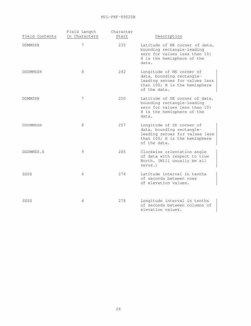
DDMMSSH 7 235 Latitude of NE corner of data,bounding rectangle—leadingzero for values less than 10;H is the hemisphere of thedata.
DDDMMSSH 8 242 Longitude of NE corner ofdata, bounding rectangle—leading zeroes for values lessthan 100; H is the hemisphereof the data.
DDMMSSH 7 250 Latitude of SE corner of data,bounding rectangle—leadingzero for values less than 10;H is the hemisphere of thedata.
DDDMMSSH 8 257 Longitude of SE corner ofdata, bounding rectangle—leading zeroes for values lessthan 100; H is the hemisphereof the data.
DDDMMSS.S 9 265 Clockwise orientation angleof data with respect to trueNorth. (Will usually be allzeros.)
SSSS 4 274 Latitude interval in tenthsof seconds between rowsof elevation values.
SSSS 4 278 Longitude interval in tenthsof seconds between columns ofelevation values.

MIL-PRF-89020B
27
Field Length CharacterField Contents In Characters Start Description0000-9999 4 282 Number of Latitude lines.
For magnetic tape, this is theactual count of the number oflatitude points (rows thatcontain data).For CD-ROM, this is the countof the number of latitudepoints in a full one-degreecell. (e.g. 1201 for DTED1,3601 for DTED2.
0000-9999 4 286 Number of Longitude lines.For magnetic tape, this is theactual count of the number oflongitude points (columns thatcontain data).For CD-ROM, this is the countof the number of longitudepoints in a full one-degreecell. The count is based onthe level of DTED and thelatitude zone of the cell.(See Table II and III).
00 or 01-99 2 290 Partial Cell Indicator00 = Complete 1° cell01-99 = % of data coverage.
101 292 Reserved for NIMA use only.(Free text or Blank filled.)
100 393 Reserved for producingnation use only. (Free textor blank filled.)
156 493 Reserved for free textcomments. (Free text orBlank filled.)
e. Accuracy Description (ACC) Record. The ACC is used formagnetic tape and CD-ROM.
Fixed Length = 2700 ASCII Characters
Field Length CharacterField Contents In Characters Start DescriptionACC 3 1 Recognition Sentinel.
0000-9999 or 4 4 *Absolute Horizontal AccuracyNot Available (NA) of Product in meters
0000-9999 or 4 8 *Absolute Vertical AccuracyNot Available (NA) of Product in meters
0000-9999 or 4 12 *Relative (Point-to-Point)Not Available (NA) Horizontal Accuracy of Product
in meters.

MIL-PRF-89020B
28
Field Length CharacterField Contents In Characters Start Description
0000-9999 or 4 16 *Relative (Point-to-Point)Not Available (NA) Vertical Accuracy of Product
in meters.
4 20 Reserved for future use.(Blank filled.)
1 24 Reserved for NIMA use only.
31 25 Reserved for future use.(Blank filled.)
00 or 02-09 2 56 Multiple Accuracy OutlineFlag. 00 = No accuracysubregions provided.02-09 = Number of accuracysubregions per 1° cell(maximum 9).
Note: *If Product has subregional accuracies, the overall accuracy of theproduct will be the worst accuracy.
Start of Accuracy Sub region Description. Repeat tomaximum of nine times. Only the number of subregionsdefined in the Multiple Accuracy Outline Flag arepopulated. Blank fill all unused coordinate pairswithin a subregion. (1 Sub region = 284 ASCIICharacters). Refer to 3.13.5.1 for accuracysubregion description.
0000-9999 or 4 58 Absolute Horizontal AccuracyNot Available (NA) of Sub region in meters
0000-9999 or 4 62 Absolute Vertical AccuracyNot Available (NA) of Sub region in meters.
0000-9999 or 4 66 Relative (Point-to-Point)Not Available (NA) Horizontal Accuracy of
Sub region in meters.
0000-9999 or 4 70 Relative (Point-to-Point)Not Available (NA) Vertical Accuracy of Subregion
in meters.

MIL-PRF-89020B
29
Field Length CharacterField Contents In Characters Start Description
03-14 2 74 Number of coordinates inaccuracy sub region outline.(Maximum of 14 coordinatepairs. The first coordinateis the most southwestern.Coordinates are inputclockwise. Implied closingfrom last to first coordinatepairs.)
Start of Coordinate Pair Description. Repeat tomaximum of fourteen times to outline subregion. Blankfill all unused accuracy subregions and unusedportions of subregions.
DDMMSS.SH 9 Latitude—leading zero forvalues less than 10; H isthe hemisphere ofthe data.
DDDMMSS.SH 10 Longitude—leading zero forvalues less than 100; H is thehemisphere of the data.
End Coordinate Pair Description
End Accuracy Sub region Description
18 2614 Reserved for NIMA use only.
69 2632 Reserved for future use.

MIL-PRF-89020B
30
f. Data Record Description. The Data Record is used for magnetic tapeand CD-ROM.Each elevation is a true value as determined by the Earth Gravity
Model (EGM) 1996 recorded to the nearest meter. The horizontal position isreferenced to precise longitude-latitude locations in terms of the currentWorld Geodetic System (WGS), determined for each file by reference to theorigin at the southwest corner. The elevations are evenly spaced inlatitude and longitude at the interval designated in the user header labelin South to North profile sequence.
Field LengthField Contents In Bytes Description
2528 1 Recognition Sentinel.
Data block count 3 Sequential count of the block withinthe file, starting with zero for thefirst block (Fixed Binary).
Longitude count 2 Count of the meridian. Truelongitude = longitude count x datainterval + origin (Offset from theSW corner longitude) (Fixed Binary).
Latitude count 2 Count of the parallel. Truelatitude = latitude count x datainterval + origin (Offset from theSW corner latitude) (Fixed Binary).
Elevation 1 2 True elevation value of point 1 ofmeridian in meters (Fixed Binary).
Elevation 2 2 True elevation value of point 2of meridian in meters (FixedBinary).
Elevation N 2 True elevation value of point N ofmeridian in meters (Fixed Binary).
Checksum 4 Algebraic addition of contents ofblock. Sum is computed as aninteger summation of 8-bit values(Fixed Binary).
Note: Fixed Binary denotes signed magnitude, right-justified binary integers.
g. File Trailer Label (EOF). The EOF is used for magnetic tape.
Field LengthField Contents In Characters Description
EOF 3 Recognition Sentinel.
1 1 Fixed by standard.
Note: (See HDR for remainder of EOF fields.)

MIL-PRF-89020B
31
h. User Trailer Label (UTL). The UTL is used for magnetic tape.Field Length
Field Contents In Characters DescriptionUTL 3 Recognition Sentinel.
1 1 Fixed by standard.Note: (See UHL for remainder of UTL fields.)
3.13 Explanation of records and fields (DTED) .
3.13.1 Volume header label (VOL). This record is required for labeledtapes in accordance with American National Standards Institute (ANSI) standardX3.27-1978, Magnetic Tape Labels for Information Interchange.
3.13.2 File header label (HDR). This record is required for labeledtapes in accordance with ANSI standard X3.27-1978, Magnetic Tape Labels forInformation Interchange.
3.13.3 User Header Label (UHL). ANSI standard allows an optional userheader label in the first file of a labeled tape. Several computermanufacturers have implemented tape labeling in such a way that the userheader label in the first file of the tape is inaccessible.
3.13.3.1 Fields(UHL). The following are explanations of fields withinthe UHL.
a. Longitude of Origin - Origin is always a ful l degree valueeven though the format allows values to be expressed to the second.
b. Latitude of Origin - Origin is always a full degree value eventhough the format allows values to be expressed to the second.
c. Seconds Longitude Interval - A ce ll of DTED is North-Southoriented with columns of elevation posts running from south to north. Thelongitude interval is the East-West distance between the columns expressed astenths of seconds.
d. Seconds Latitude Interval - The spacing between th e elevationposts within a column (i.e., the distance between the rows) is the latitudeinterval expressed in tenths of a second.
e. Number of longitude lines - The number of longitude linesfield always reflects a full DTED cell in the UHL. This value is based on thelevel of DTED and the latitude zone of the cell (see Table I, II, and III).
f. Number of latitude points - The number of latitude pointsfield always reflects a full DTED cell in the UHL. ( DTED Level 0 = 121,Level 1 = 1201, and Level 2 = 3601)
3.13.4 Data Set Identification (DSI) Record. This record providesidentification and security information relating to the DTED. The record isfixed length consisting of 648 ASCII characters. Each character isrepresented by 1 tape byte or 8 bits. Certain fields in the DSI record areduplicated in the UHL/UTL.
Note: Numeric values shall be right justified with leading zeros. Alphaand alphanumeric characters shall be left justified unless ‘free text’ isindicated in description.

MIL-PRF-89020B
32
3.13.4.1 Fields(DSI).
a. Security control and release markings - This field may containthe two character codes or may be blank filled
b. NIMA series designator - Five character code to uniquelyidentify a product. DTED0 for Level 0, DTED1 for Level 1, or DTED2 for Level2.
c. Unique reference number - Free text or zero filled.
d. Data edition number - The number assigned to the dataindicating either original compilation (Edition 1) or subsequent replacementsof the data (Editions 2, 3, etc.) in the Data Base (DB) to achieve accuracyrequirements (recompilation) or currency/specification requirements(revision). The data edition number does not reflect the number ofreplacements made to the data to effect boundary matches.
e. Match/merge version - The number of times an edition of thedata was changed to effect boundary continuity with adjacent data in the DB.Alphabetic Code A denotes original release of the edition, B - Z designatesdata change for boundary continuity.
f. Maintenance date - YYMM (year and month); The date existing DBdata was either revised (updated) to meet the currency requirements (or toeffect specification changes), or recompiled to meet accuracy requirements.When the existing data is only revised (horizontal position or vertical valuesare not significantly changed) the maintenance date will reflect the date ofthe revision, but the compilation date will not be changed. It will continueto reflect the date of the original compilation. However, when the data issubjected to a major recompilation, the Compilation Date and the MaintenanceDate will both be changed to reflect the date of the recompilation.
g. Match/merge date - YYMM (year and month); The latest date thedata in the database (DB) was changed to effect continuity with adjacent data.This data corresponds to the Match/Merge Version Code.
h. Maintenance description code - Zero filled until used.
i. Producer code - The first two characters (left justified)indicate the producing nation and are from FIPS 10-4 Countries, Dependencies,Areas of Special Sovereignty and Their Principal Administrative Divisions.The last six characters are to be used at the discretion of the producer.Blanks are acceptable. Example codes:
Belgium BE Norway NOFrance FR Spain SPUnited Germany GE United Kingdom UKItaly IT United States USNetherlands NL
j. Product specification - Identifies the product specificationcontaining the compilation and accuracy requirements used to produce the data.Data produced to this specification will contain PRF89020B.
k. Product specification amendment and change number - Indicatesthe highest numbered amendment or change used to produce the data. The firstcharacter identifies the Amendment number and the second character identifiesthe Change Notice number. (Amendment 0, Change 1-01; Amendment 2, Change 2-22;etc.)

MIL-PRF-89020B
33
l. Date of product specification - Identifies the published dateof the product specification used to produce the data
m. Vertical datum code - MSL or E96.
n. Horizontal datum code - Identifies the version of WGS to whichthe product is horizontally controlled. During original compilation DTED usesthe WGS datum then in effect for NIMA use. Upon transition to a new WGS datumthe existing DTED can be:
(1) Recompiled from an original source; and therefore carry a newEdition number.
(2) Recompiled by mathematically adjusting the elevation values;and therefore carry a new Edition number.
(3) Revised by defining the same elevations as compatible with thenew WGS datum within the accuracy evaluations quoted; and therefore carry thesame Edition number but with a new Maintenance Date.
o. Digitizing collection system - Identifies the equipment usedto collect the elevation values from the source material used, e.g., AGDS,LIS, UNAMACE, AS11, DE/S, PG/S, SRTM etc.
p. Compilation date - YYMM (year and month); The date the datawas either originally compiled (Edition 1) or the date existing data wassubjected to a major recompilation which involved significant changes to thehorizontal positions and vertical values. (Edition 2, 3, 4, etc.)
q. Latitude of origin - Expressed in degrees, minutes, secondsand tenths of seconds with N or S to indicate hemisphere (always a full degreevalue even though the format allows value to be expressed to tenths ofseconds).
r. Longitude of origin - Expressed in degrees, minutes, secondsand tenths of seconds with E or W to indicate hemisphere (always a full degreevalue even though the format allows value to be expressed to tenths ofseconds).
s. Number of latitude lines - The number of latitude lines fieldfor a DTED cell in the CD-ROM format always reflects a full cell (DTED Level 1= 1201, Level 2 = 3601). CD-ROM format always has a full array of data. (See3.11.3.2.1)
The number of latitude lines for a DTED cell on magnetic mediareflects the actual count of rows that contain valid elevation values. DTEDpartial cells on magnetic media do not always have a full array of data. (See3.11.3.2.2.)
t. Number of longitude lines - The number of longitude linesfield for a DTED cell in CD-ROM format always reflects a full cell in the DSI.This value is based on the level of the DTED cell and the latitude zone thecell falls within ( See Table II, and III). This is due to the CD-ROM formatalways having a full array of data.
The number of longitude lines field for a DTED cell onmagnetic media reflects the actual count of longitude columns that containvalid elevation values DTED partial cells on magnetic media do not alwayshave a full array of data. ( See 3.11.3.2.2)
3.13.5 Accuracy description record (ACC). The accuracy record providesaccuracy information relating to the DTED. The record is fixed length

MIL-PRF-89020B
34
consisting of 2700 ASCII characters. Each character is represented by 1 byteor 8 bits. The record allows for up to nine accuracy sub regions within theproduct should the accuracies of various portions of this product differ.Each sub region may consist of up to fourteen coordinate pairs to accuratelyportray the outline. Coordinates are input clockwise. Unused coordinatepairs are blank filled.
Note: Numeric values shall be right justified with leading zeros. Alphaand alphanumeric characters shall be left justified.
3.13.5.1 Accuracy sub region description. A sub region descriptioncontains the sub region accuracies, the number of sub region coordinate pairsand the actual coordinate pairs which define the sub region area. Unused subregions and/or unused coordinate pairs within a sub region will be blankfilled. The sub regions will be organized as follows:
a. The first coordinate pair of the first sub region must be thesouthwest corner of the bounding rectangle.
b. The first coordinate pair of each sub region must be the mostsouthern and western point in the sub region. Southern takes precedence overwestern.
c. The first coordinate pair of each sequential sub region mustbe arranged in a clockwise direction starting with the first sub region. Subregions which contain at least part of a degree line will take precedence andbe numbered clockwise, starting in the SW corner and proceeding around thefour bounding degree lines. Remaining sub regions will be numbered in a southto north, west to east manner based on initial point within each sub region.
d. Coordinate pairs within a sub region must be arranged in aclockwise direction.
e. Each sub region coordinate pair must be located on or withinthe bounding rectangle.
f. Each coordinate pair in the bounding rectangle must berepresented as a sub region coordinate pair.
g. Sub region areas must not overlap or leave gaps. The entirearea defined by the bounding rectangle must be covered by sub region areas(i.e. the sum of the sub regions must equal the 1° product area).
h. The first and last coordinate pairs of a sub region shall notbe the same. Closure of the sub region area is implied.
i. A sub region can only be generalized if all of the sub regiondescriptions have been used.
j. Sub region format:Field Length Character
Sub region Number in Characters Start1 284 582 284 3423 284 6264 284 9105 284 11946 284 14787 284 17628 284 20469 284 2330

MIL-PRF-89020B
35
3.14 User’s responsibilities.
a. Procedures applicable for protection of c lassified data arecontained in NIMA Instructions:
5200.1, Information Security, 8 May 1998.5220.1, Industrial Security, 10 February 1999.
b. The DTED on CD-ROM or magnetic tape is MC&G Property forpurposes of the Defense Federal Acquisition Regulations (DFARS). Digitalproducts produced by NIMA in support of DoD requirements are DefenseInformation. While classification may not be required, the increasing size ofthe completed data bases represents a national resource. Therefore, DMAInstruction 8660.10, Release, Distribution, Handling, and Storage of DefenseMapping Agency (DMA) Digital Mapping, Charting, and Geodesy (MC&G) Data,establishes policies and procedures limiting unconstrained access. Recipientsof NIMA digital data must protect their holdings against misuse or loss.Whenever the digital products are not under supervision of authorized persons,the data must be secured in a container or vault that provides physicalevidence of unauthorized tampering or forced entry.
c. Reproduction for further distribution outside the primaryrecipient’s organizational structure of any amount of DTED is not authorizedwithout the written permission of the National Imagery Mapping Agency.Requests for such permission are to be sent to:
Director, National Imagery and Mapping AgencyAttn: Customer Support/DF (P-37)12310 Sunrise Valley DriveReston VA 20191-3499
d. Digital data derived from data produced by other nations undercooperative agreements may be subject to additional restrictions, copyrights,or classification. These restrictions must be honored when such digital datais distributed.
e. The data structure and information content of NIMA’s digitalproducts are prescribed by NIMA Product Specifications or MilitarySpecifications. Deletions, additions, or modifications to NIMA’s digitalfiles by users become local transaction files (no longer NIMA products) andare the responsibility of the user to control.
f. Destruction notice for DTED CD-ROMs.Unclassified DTED CD-ROMs: Destroy by any method that will prevent
disclosure of contents or reconstruction of the disc.Classified DTED CD-ROMs: Follow the procedures in NIMA 5220.1,
Industrial Security, 10 February 1999 or NIMA 5200.1, Information Security, 8May 1998.
g. Correspondence concerning the quality of the CD-ROM shall beforwarded to:
Director NIMA Dissemination Services Requirements Department
Attn:IS/DSNR, MS J-703200 South Second St.
St. Louis, MO 63118-3399
3.15 Copyright.

MIL-PRF-89020B
36
a. Copyright protection is asserted for all products generated bythese specifications which are distributed outside of the United States. Nodomestic copyright will be asserted.
b. The copyright notice (with year of production inserted)states:
© COPYRIGHT (year of production) BY THE UNITED STATES GOVERNMENT.NO COPYRIGHT CLAIMED UNDER TITLE 17 U.S.C.
3.16 CD-ROM labeling. See NIMA Instruction 8955.1 for guidelines forlabeling National Imagery Mapping Agency CD-ROMs, and printing and finishingof jewel case liners/cardboard sleeves, and information booklets.
3.16.1 Information booklet. An information booklet will providegeneral information (similar to the READ.ME file) about the contents of theCD-ROM, handling instructions, distribution/user information, and NIMA pointsof contact.
4. VERIFICATION
4.1 Classification of inspection. The inspection requirements specifiedherein are classified as follows:
a. First article inspection (see 4.2).
b. Conformance inspection (see 4.3).
4.2 First article inspection. When a first article inspection isrequired (see 3.1), it shall be examined as specified in 4.3.1, and tested asspecified in 4.3.2.
4.3 Conformance inspection. Quality conformance inspection shallinclude the examination of 4.3.1 and the tests of 4.3.2.
4.3.1 Examination. The database shall be examined for compliance withthe requirements specified in section 3. Unless a waiver has been granted noncompliance with any of the specified requirements shall constitute cause forrejection.
4.3.2 Tests. A sample determined by the contracting officer shall beread back after generation to ensure that the requirements specified insection 3 have been met.
4.4 Government furnished material. The contractor shall not duplicate,copy, or otherwise reproduce the MC&G property for purposes other than thosenecessary for performance of the contract.
4.5 Government property surplus. At the completion of performance ofthe contract, the contractor, as directed by the contracting officer, shalleither destroy or return to the Government all government-furnished MC&Gproperty not consumed in the performance of the contract.
5. PACKAGING
5.1 Packaging. For acquisitions purposes, the packaging requirementsshall be as specified in the contract or order (see 6.2). When actualpackaging of material is to be performed by DoD personnel, these personnelneed to contact the responsible packaging activity to ascertain requisitepackaging requirements. Packaging requirements are maintained by theInventory Control Point's packaging activity within the Military Department or

MIL-PRF-89020B
37
Defense Agency, or within the Military Department's Systems Command.Packaging data retrieval is available from the managing Military Department'sor Defense Agency's automated packaging files, CD-ROM products, or bycontacting the responsible packaging activity.
6. NOTES.
This section contains information of a general or explanatory naturethat may be helpful, but is not mandatory.
6.1 Intended use. This specification defines the content of DigitalTerrain Elevation Data (DTED) which supports military weapon and trainingsystems. The data covered by this specification is military unique because itis not releasable to the public and restricted to DoD users and contractors.
6.2 Acquisition Requirements. When this specification is used inacquisition, the applicable issue of the Department of Defense Index ofSpecifications and Standards (DODISS) must be cited in the solicitation (See2.1 and 2.2).
6.3 Supersession. This specification supersedes MIL-PRF-89020APerformance Specification for Digital Terrain Elevation Data, 19 April 1996with Amendment 1, 27 April 1999.
6.4 Definitions.
6.4.1 Accuracy. The degree of conformity with which horizontalposition and vertical values are represented on a map, chart, or relatedproduct in relation to an established standard.
a. Horizontal accuracy, absolute. The uncertainty in thehorizontal position of a point with respect to the World Geodetic Systemcaused by random and uncorrected systematic errors. The value is expressed asa circular error at the 90% confidence level.
b. Horizontal accuracy, relative or point-to-point. Theuncertainty in horizontal position between two points caused by random errors.The value is expressed as a circular error at the 90% confidence level.
c. Vertical accuracy, absolute. The uncertainty in the heightof a point with respect to Mean Sea Level caused by random and uncorrectedsystematic errors. The value is expressed as a linear error at the 90%confidence level.
d. Vertical accuracy, relative or point-to-point. The uncertaintyin height between two points caused by random errors. The value is expressedas a linear error at the 90% confidence level.
6.4.2 Cell. 1° by 1° area of coverage.
6.4.3 Circular error. An accuracy figure representing the statedpercentage of probability that any point expressed as a function of two linearcomponents (for example, latitude and longitude or northing and easting) willbe within the given figure.
6.4.4 DTED. A geographic matrix of terrain elevation data pointsconverted into a numerical format for computer storage and analysis at preciseincrements of latitude and longitude. The precise increment depends upon thelatitude and the DTED level. Elevation values are expressed in meters.

MIL-PRF-89020B
38
a. DTED Level 0 - Precise 30 arc second horizontal positionreferenced to the origin of the southwest corner, evenly spaced in latitudeand longitude in a South to North profile sequence.
b. DTED Level 1 - Precise 3 arc second horizontal positionreferenced to the origin of the southwest corner, evenly spaced in latitudeand longitude in a South to North profile sequence.
c. DTED Level 2 - Precise 1 arc second horizontal positionreferenced to the origin of the southwest corner, evenly spaced in latitudeand longitude in a South to North profile sequence.
6.4.5 Linear error. Linear error is the difference between the true orknown value and the measured or derived value, and is normally expressed interms of a percentage probability level. For example, LE 90% is the term usedto express the linear error at 90% probability, which is the Map AccuracyStandard. This refers to the vertical accuracy of terrain elevations in thedigital data base.
6.4.6 Mean Sea Level (MSL). The average height of the surface of thesea for all stages of the tide, used as a reference for elevations.
6.4.7 Nautical mile. 6076 feet; 1852 meters (international value).
6.4.8 Off-line digital data base. Magnetic media containing informationin digital form including header information, geographic coordinates anddescriptive information for planimetric features and terrain within a specificgeographic area.
6.4.9 WGS (World Geodetic System). A geodetic reference systemconsisting of a set of parameters describing the size and shape of the Earth,an Earth-center Earth-fixed coordinate reference system, the positions of anetwork of points with respect to the center of mass of the Earth, and thegravitational model of the Earth (usually in terms of harmonic coefficients),a global geoid.
6.4.10 VMAP0. DTED Level 0 data derived from VMAP0 terrain contoursis identified in the DSI record.
6.4.11 TAR file. A Unix Tape Archive format. A single file whichencapsulates and compresses a number of other files.
6.5 Subject term (key word) listing.
CD-ROM1 degree by 1 degree (1o by 1o cell) cell
6.6 Standardization agreements. Certain provisions of thisspecification may be subject to international standardization agreement. Whenamendment, revision, or cancellation of this specification is proposed thatwill modify the international agreement concerned, the preparing activity willtake appropriate action through international standardization channels,including departmental standardization offices, to change the agreement ormake other appropriate accommodations.
6.6.1 International Standardization Agreements (STANAGs) .
a. DTED Level 1 and DTED Level 2 -

MIL-PRF-89020B
39
(1) STANAG 3809, "Digital Terrain Ele vation Data ExchangeFormat".
(2) STANAG 2211, "Geodetic Datums, Spheroids, Grids and Grid References".
6.7 Changes from previous issue. The margins of this specificationare marked with side bars to indicate where changes from the previous issuewere made. This was done as a convenience only and the Government assumes noliability whatsoever from any inaccuracies in these notations. Bidders andcontractors are cautioned to evaluate the requirements of this document basedon the entire content, irrespective of the marginal notations and relationshipto the last previous issue.
6.8 Y2K century logic. For this product, the year is represented by atwo-character year field. Implementers of this product should use a centurylogic that is consistent with the fact that the first data set for thisproduct was produced in 1977.
6.9 NIMA Customer Help Desk.
For questions concerning this or other NIMA Products or Services, pleasetelephone the NIMA Customer Help Desk, at 1-800-455-0899, Commercial 314-263-4751, or DSN 693-4751.

MIL-PRF-89020B
40
SW latitude + SW longitude+ Data edition+ Match/merge version + 15' Quad(1,16)
DTED
+
GAZETTE
+
DMED·
+
TEXT
< Η λλλ > (1, Ρ)
UHL record+ DSI record+ ACC record+ elevation profiles(1,E)
min e + max e + mean e + std dev e
designation code+ latitude+ longitude + place name
· GAZ (1,N)
· HSH
GAZETTE·DIR (1,1)
GAZETTE·Key (1,1)
<Country> (1,G)
MBR
+
DMED Cell (1,T)
ONC·DIR
READ·ME
< Η ϕϕ > (1, ∆)
·DT1
- hemisphere (E or W) and longitude - hemisphere (N or S) and latitude - number of 1° cell columns within the disc, a multiple of 6 - number of 1° DTED cells within the columns, a multiple of 6E - number of profiles per cell (latitude zone dependent, 1201 elevations per profile)G - number of country/region gazettes on the disc N - number of place names within the country/region gazette T - total number of 1° cells on disc = P x ∆ , a multiple of 6
∆ Ρ
Η λλλΗ ϕϕ
FIGURE 1. DTED Level 1 CD-ROM logical data file structure .

MIL-PRF-89020B
PARAGRAPH PAGE
41
Accuracy...................................................3.3 3Accuracy...................................................6.4.1 37Accuracy description record (ACC)..........................3.13.5 33Accuracy sub region description............................3.13.5.1 34Acquisition requirements...................................6.2 37Adjacent one-degree data files.............................3.5.2 4APPLICABLE DOCUMENTS.......................................2. 1
Below mean sea level.......................................3.5.3.3 5
CD-ROM characteristics.....................................3.6.1.1 5CD labeling................................................3.10.7.3.1 12CD-ROM content.............................................3.10.7.1 12CD-ROM labeling............................................3.16 36CD-ROM labeling and packaging..............................3.10.7.3 12Cell.......................................................6.4.2 37Change from previous issue.................................6.7 39Circular error.............................................6.4.3 37Classification.............................................1.3 1Classification of inspection...............................4.1 36Conformance inspection.....................................4.3 36Copyright..................................................3.15 35
Data block checksum........................................3.10.6 12Data file structure........................................3.10.1 11Data record characteristics................................3.11 14Data record sequence.......................................3.10.5 12Data Set Identification (DSI) Record.......................3.13.4 31Data value sequence........................................3.10.4 11Datum......................................................3.2 3Definitions................................................6.4 37Description of record contents.............................3.12 19Directories................................................3.10.7.2 12DMED file..................................................3.9.5 9Double line drains.........................................3.5.3.1.2 5DTED.......................................................6.4.4 37DTED File descriptions on CD-ROM or the GATEWAY............3.9 7DTED files.................................................3.10.7.4 13DTED Level 0...............................................3.5.4 5DTED Level 1...............................................3.5.5 5DTED Level 1 Accuracy......................................3.3.1 4DTED Level 2...............................................3.5.6 5DTED Level 2 Accuracy......................................3.3.2 4DTED on Compact Disc-Read Only Memory (CD-ROM).............3.10.7 12DTED Surface Characteristics...............................3.5.3 5
Eight Millimeter (8mm) Tape................................3.6.2.2 6Evaluation values..........................................3.11.2 15Examination................................................4.3.1 36Explanation of record and fields (DTED)....................3.13 31
Fields (DSI)...............................................3.13.4.1 32Fields (UHL)...............................................3.13.3.1 31File header label (HDR)....................................3.13.2 31Files extent...............................................3.10.2 11First article..............................................3.1 3First article inspection...................................4.2 36Flattened water bodies.....................................3.5.3.1.1 5
Gazetteer directory........................................3.9.6.1 10

MIL-PRF-89020B
PARAGRAPH PAGE
42
GAZETTE.DIR................................................3.9.6.5 11GAZETTE.KEY................................................3.9.6.4 11Gazetteer file.............................................3.9.6 10General....................................................2.1 1Government documents.......................................2.2 2Government furnished material..............................4.4 36Government property surplus................................4.5 36
Hash file..................................................3.9.6.3 10Horizontal datum...........................................3.2.1 3
Individual cell record.....................................3.9.5.1 9Information booklet........................................3.16.1 36Intended use...............................................6.1 37International Standardization Agreements (STANAGs).........6.6.1 38Islands....................................................3.5.3.2.2 5
Land.......................................................3.5.3.2 5Linear error...............................................6.4.5 38Logical file characteristics...............................3.10 11
Magnetic Tape File Structure Diagram.......................3.10.8 14Mean Sea Level (MSL).......................................6.4.6 38Missing elevation..........................................3.11.3.2 15
Nautical mile..............................................6.4.7 38NIMA Customer Help Desk....................................6.9 39NIMA Gateway...............................................3.8 7Nine (9) Track Tape........................................3.6.2.1 6Non-government publications................................2.3 3NOTES......................................................6 37Null elevations............................................3.11.3.1 15Numeric value..............................................3.11.1 15
Off-line digital data base.................................6.4.8 38ONC.DIR file...............................................3.9.1 8One-degree cell............................................3.5.1 4Order of precedence........................................2.4 3Other Government documents, drawings, and publications.....2.2.2 2
PACKAGING..................................................5. 36Packaging..................................................5.1 36Partial cells..............................................3.11.3 15Physical Characteristics of CD-ROM.........................3.6.1 5Physical Characteristics of magnetic tape..................3.6.2 5Primary file...............................................3.9.6.2 10Product description........................................3.5 4Purpose....................................................1.2 1
Read.me....................................................3.9.4 9Record characteristics on Magnetic Tape....................3.7 6REQUIREMENTS...............................................3. 3
SCOPE......................................................1. 1Scope......................................................1.1 1Security...................................................3.4 4Security classification....................................3.4.1 4Shorelines and coastlines..................................3.5.3.2.1 5Shuttle Radar Topography Mission (SRTM) DTED...............3.10.9 14Specifications, standards, and handbooks...................2.2.1 2

MIL-PRF-89020B
PARAGRAPH PAGE
43
SRTM Accuracies............................................3.10.9.4 14SRTM Accuracy Description (ACC) Record contents............3.10.9.3 14SRTM Data Set Identification (DSI) Record contents.........3.10.9.2 14SRTM DTED reflective surface...............................3.10.9.5 14SRTM DTED waterbodies......................................3.10.9.6 14Standard format............................................3.6 5Standardization agreements.................................6.6 38Subject term (key word) listing............................6.5 38Supersession...............................................6.3 37
TAR file...................................................6.4.11 38Terrain elevation intervals................................3.10.3 11Tests......................................................4.3.2 36The <xxx>.dt0, .dt1, and .dt2 files........................3.9.2 8The <xxx>.avg, .min, and .max files........................3.9.3 9The <xxx>.avg, .min, and .max Data Record Characteristics..3.11.4 16The <xxx>.avg, .min, and .max data values..................3.11.4.1 16Type of Input/Output (I/O).................................3.6.3 6
User Header Label (UHL)....................................3.13.3 31User's responsibilities....................................3.14 35
VERIFICATION...............................................4. 36Vertical datum.............................................3.2.2 3VMAP0......................................................6.4.10 38Voids......................................................3.10.9.1 14Volume header label (VOL)..................................3.13.1 31
Water......................................................3.5.3.1 5WGS (World Geodetic System)................................6.4.9 38
Y2K century logic..........................................6.8 39
.

MIL-PRF-89020B
44
Concluding Material
Custodian:Army - TIAir Force - 09Navy - NOMarine Corps - MCDISA - DC2
Review Activities:Air Force - 33Army - AV, CE2Coast Guard - CGDIA - DIDLA - DHMarine Corps - MCNORAD - USNSA - NS
Preparing ActivityNIMA - MP
(Project MCGT - 354)

STANDARDIZATION DOCUMENT IMPROVEMENT PROPOSALINSTRUCTIONS
1. The preparing activity must complete blocks 1, 2, 3, and 8. In block 1, both the document number and revisionletter should be given.
2. The submitter of this form must complete blocks 4, 5, 6, and 7.3. The preparing activity must provide a reply within 30 days from receipt of the form.NOTE: This form may not be used to request copes of documents, nor to request waivers, or clarification ofrequirements on current contracts. Comments submitted on this form do not constitute or imply authorization towaive any portion of the referenced document(s) or to amend contractual requirements.
I RECOMMEND A CHANGE:1. DOCUMENT NUMBERMIL-PRF-89020B
2. DOCUMENT DATE (YYMMDD)00/05/23
3. DOCUMENT TITLEDigital Terrain Elevation Data (DTED)
4. NATURE OF CHANGE (Identify paragraph number and include proposed rewrite, if possible. Attach extra sheets as needed.)
5. REASON FOR RECOMMENDATION
6. SUBMITTERa. NAME (Last, First, Middle Initial) b. ORGANIZATION
c. ADDRESS (Include Zip Code) d. TELEPHONE (Include Area Code)(1) Commercial(2) AUTOVON
(If applicable)
7. DATE SUBMITTED (YYMMDD)
8. PREPARING ACTIVITY
a. NAME National Imagery and Mapping Agency b. TELEPHONE (Include Area Code)(1) Commercial(703) 264-3106
(2) AUTOVON570-3106
c. ADDRESS (Include ZIP Code)National Imagery and Mapping AgencyATTN: Doctrine and Force Development /DF, Mail Stop P-3712310 Sunrise Valley DriveReston, VA 20191-3449
IF YOU DO NOT RECEIVE A REPLY WITHIN 45 DAYS, CONTACT:DLSC-LM8725 John J. Kingman Road, Suite 2533Fort Belvoir, VA 22060-6879
DD Form 1426, OCT 89 Previous editions are obsolete. 198/290