
PENNYPACK CREEK WATERSHED STORMWATER MANAGEMENT ORDINANCE · PENNYPACK CREEK WATERSHED STORMWATER...
74
A-1 PENNYPACK CREEK WATERSHED STORMWATER MANAGEMENT ORDINANCE Implementing the Requirements of the Pennypack Creek Watershed Stormwater Management Plan ORDINANCE NO.________ OF __________ _[Municipality], __[County] _ COUNTY, PENNSYLVANIA Adopted at a Public Meeting held on __________________, 20__
Transcript of PENNYPACK CREEK WATERSHED STORMWATER MANAGEMENT ORDINANCE · PENNYPACK CREEK WATERSHED STORMWATER...
A-1
PENNYPACK CREEK WATERSHED STORMWATER MANAGEMENT ORDINANCE
Implementing the Requirements of the Pennypack Creek Watershed
Stormwater Management Plan
ORDINANCE NO.________ OF __________
_[Municipality], __[County] _ COUNTY,
PENNSYLVANIA
Adopted at a Public Meeting held on
__________________, 20__
A-2
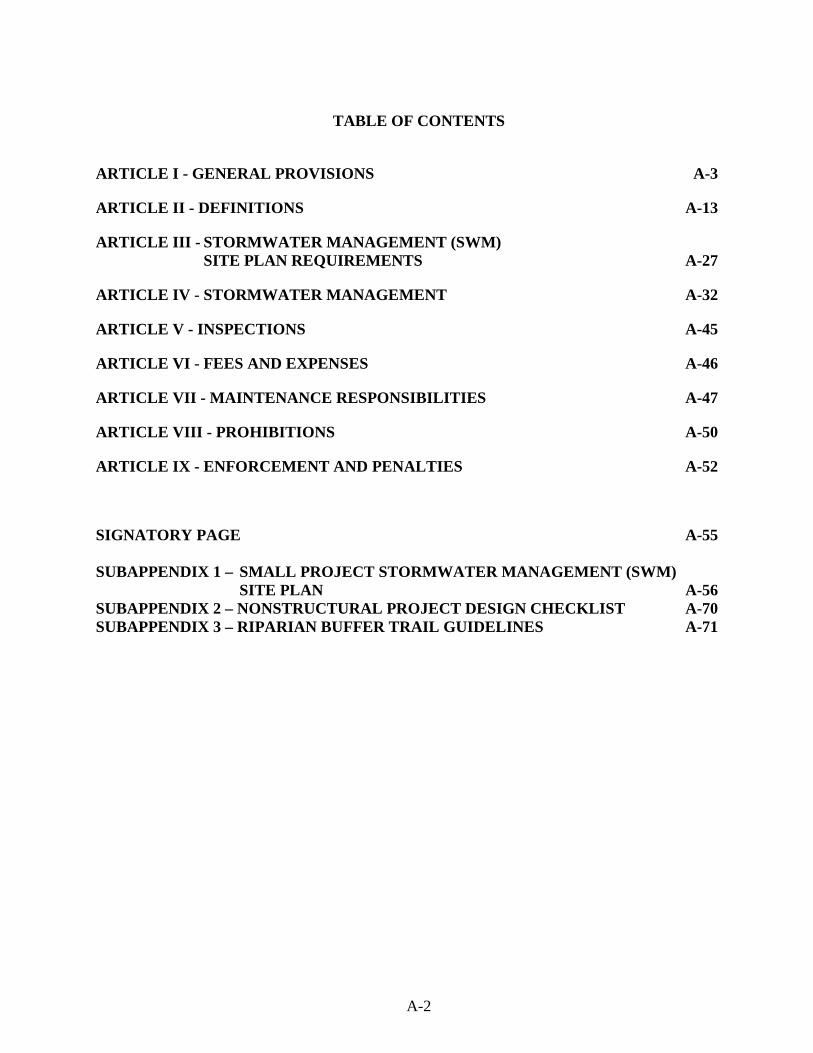
TABLE OF CONTENTS
ARTICLE I - GENERAL PROVISIONS A-3
ARTICLE II - DEFINITIONS A-13
ARTICLE III - STORMWATER MANAGEMENT (SWM) SITE PLAN REQUIREMENTS A-27
ARTICLE IV - STORMWATER MANAGEMENT A-32
ARTICLE V - INSPECTIONS A-45
ARTICLE VI - FEES AND EXPENSES A-46
ARTICLE VII - MAINTENANCE RESPONSIBILITIES A-47
ARTICLE VIII - PROHIBITIONS A-50
ARTICLE IX - ENFORCEMENT AND PENALTIES A-52
SIGNATORY PAGE A-55 SUBAPPENDIX 1 – SMALL PROJECT STORMWATER MANAGEMENT (SWM) SITE PLAN A-56 SUBAPPENDIX 2 – NONSTRUCTURAL PROJECT DESIGN CHECKLIST A-70 SUBAPPENDIX 3 – RIPARIAN BUFFER TRAIL GUIDELINES A-71

A-3
ARTICLE I - GENERAL PROVISIONS
Section 101. Short Title This Ordinance shall be known and cited as the “Pennypack Creek Stormwater Management Ordinance”.
Section 102. Statement of Findings The governing body of the Municipality finds that: A. Inadequate management of accelerated stormwater runoff resulting from development throughout a watershed increases flood flows and velocities, contributes to erosion and sedimentation, overtaxes the carrying capacity of existing streams and storm sewers, greatly increases the cost of public facilities to convey and manage stormwater, undermines floodplain management and flood reduction efforts in upstream and downstream communities, reduces groundwater recharge, and threatens public health and safety. B. Inadequate planning and management of stormwater runoff resulting from land development throughout a watershed can also harm surface water resources by changing the natural hydrologic patterns, accelerating stream flows (which increase scour and erosion of streambeds and streambanks, thereby increasing sedimentation), destroying aquatic habitat, and increasing aquatic pollutant concentrations and loadings such as sediments, nutrients, heavy metals, and pathogens. Groundwater resources are also impacted through loss of recharge. C. A comprehensive program of stormwater management, including minimization of impacts of development, redevelopment, and activities causing accelerated erosion and loss of natural infiltration, is fundamental to the public health, safety, welfare, and the protection of the people of the Municipality and all of the people of the Commonwealth, their resources, and the environment. D. Stormwater is an important resource by providing groundwater recharge for water supplies and baseflow of streams, which also protects and maintains surface water quality. E. Impacts from stormwater runoff can be minimized by using project designs that maintain the natural hydrologic regime and sustain high water quality, groundwater recharge, stream baseflow, and aquatic ecosystems. The most cost-effective and environmentally advantageous way to manage stormwater runoff is through nonstructural project design that minimizes impervious surfaces and sprawl, avoids sensitive areas (i.e., stream buffers, floodplains, steep slopes), and considers topography and soils to maintain the natural hydrologic regime. F. Public education on the control of pollution from stormwater is an essential component in successfully addressing stormwater. G. Federal and state regulations require certain municipalities to implement a program of stormwater controls. These municipalities are required to obtain a permit for stormwater discharges from their separate storm sewer systems under the National Pollutant Discharge Elimination System (NPDES).
A-4
H. Nonstormwater discharges to municipal separate storm sewer systems can contribute to pollution of waters of the Commonwealth by the Municipality.
Section 103. Purpose The purpose of this Ordinance is to promote the public health, safety, and welfare within the Pennypack Creek Watershed by maintaining the natural hydrologic regime and by minimizing the harms and maximizing the benefits described in Section 102 of this Ordinance, through provisions designed to: A. Promote alternative project designs and layouts that minimize the impacts on surface and groundwater. B. Promote stormwater Best Management Practices (BMPs). C. Minimize increases in runoff stormwater volume. D. Minimize impervious surfaces. E. Manage accelerated stormwater runoff, erosion and sedimentation problems, and stormwater runoff impacts at their source by regulating activities that cause these problems. F. Provide review procedures and performance standards for stormwater planning and management. G. Utilize and preserve existing natural drainage systems as much as possible. H. Manage stormwater impacts close to the runoff source, requiring a minimum of structures and relying on natural processes. I. Focus on infiltration of stormwater to maintain groundwater recharge, prevent degradation of surface and groundwater quality, and protect water resources. J. Maintain existing baseflows and quality of streams and watercourses. K. Meet legal water quality requirements under state law, including regulations at 25 Pennsylvania Code Chapter 93.4.a requiring protection and maintenance of “existing uses” and maintenance of the level of water quality to support those uses in all streams, and the protection and maintenance of water quality in “special protection” streams. L. Address the quality and quantity of stormwater discharges from the development site. M. Provide standards necessary to meet NPDES permit requirements. N. Implement an illegal discharge detection and elimination program that addresses non-stormwater discharges into the Municipality’s separate storm sewer system.
A-5
O. Preserve the flood-carrying capacity of streams. P. Prevent scour and erosion of streambanks and streambeds. Q. Provide performance standards and design criteria based on watershed-wide stormwater management and planning. R. Provide proper operation and maintenance of all stormwater management facilities and BMPs that are implemented in the Municipality.
Section 104. Statutory Authority The Municipality is empowered to regulate land use and activities that may affect runoff and surface and groundwater quality and quantity by the authority of: A. Primary Authority.
The Municipality is empowered to regulate land use activities that affect runoff and surface and groundwater quality and quantity by the authority of the Act of October 4, 1978, P.L. 864 (Act 167), 32 P.S. Section 680.1, et seq., as amended, the “Storm Water Management Act” and the (appropriate municipal code). In addition, the City of Philadelphia’s stormwater regulations prescribe stormwater management requirements for development and post-development stormwater management control. These regulations are available online at: http://www.phillyriverinfo.org/programs/subprogrammain.aspx?Id=Regulations
B. Secondary Authority.
The municipality also is empowered to regulate land use activities that affect runoff by the authority of the Act of July 31, 1968, P.L. 805, No. 247, The Pennsylvania Municipalities Planning Code, as amended.
Section 105. Applicability All Regulated Activities and all activities that may affect stormwater runoff, including Land Development and Earth Disturbance Activities, are subject to regulation by this Ordinance. This Ordinance shall apply to those portions of the Municipality that lie within the Pennypack Creek Watershed, in accordance with the Stormwater Management Districts established in Section 408, and shall apply only to stormwater BMPs constructed as part of any of the regulated activities listed in this section. In addition, all applicable development in Philadelphia County must comply with The City of Philadelphia’s stormwater regulations, which are available online at http://www.phillyriverinfo.org/programs/subprogrammain.aspx?Id=Regulations.
A-6
Furthermore, all applicable development in Philadelphia County must comply with the latest version of the “Stormwater Management Guidance Manual” (currently Version 2.0), prepared by the Philadelphia Water Department Office of Watersheds. This manual is available online at: http://www.phillyriverinfo.org/PWDDevelopmentReview/RequirementsLibrary.aspx?. The site contains several checklists that have been developed to assist the user in complying with the City of Philadelphia’s regulations. Regulated Activities include the following: a) Land development, b) Subdivisions, c) Alteration of the natural hydrologic regime, d) Construction or reconstruction (see definition in Section 202.B) of or addition of new impervious or semi-pervious surfaces (i.e., driveways, parking lots, roads, etc.), e) Construction of new buildings or additions to existing buildings, f) Redevelopment, g) Diversion piping or encroachments in any natural or man-made channel, h) Stormwater BMPs or appurtenances thereto, i) Earth disturbance activities of equal to or greater than five thousand (5,000) square feet,
j) Any of the above regulated activities which were approved more than five (5) years prior to the effective date of this Ordinance and resubmitted for municipal approval. k) (The following note applies to those portions of the Pennypack Creek Watershed that lie within Bucks and Montgomery Counties.) This Ordinance applies to any earth disturbance activity equal to or greater than five thousand (5,000) square feet that is associated with a development or redevelopment project. Earth disturbance activities of between 5,000 square feet and one (1) acre that are associated with either development or redevelopment projects have drainage plan requirements per Table 106.1, and those that are associated with redevelopment are exempt from the Section 407 stream bank erosion requirements. Earth disturbance activities and associated stormwater management controls are also regulated under existing state law and implementing regulations. Section 106. Exemptions
A. Tables 106.1 summarize the eligibility for exemptions from certain requirements in this Ordinance. “Proposed Impervious Surface” in Table 106.1 includes new, additional, or replacement impervious surface/cover. “Repaving” existing surfaces without reconstruction (see Section 202) does not constitute replacement.

A-7
Table 106.1 Eligibility for Exemptions for the Bucks and Montgomery County Portions of the Watershed
Notes: Yes – Exempt unless a determination is made by the municipality that the project is subject to Section 106.C. SWM Site Plan may still be required by other sections or provisions. No – Not exempt. All provisions apply. No* – Modified SWM Site Plan required, Small Project Site Plan possible.
- Sites with less than one thousand (1,000) square feet of new impervious surface, but between five thousand (5,000) square feet and one (1) acre of earth disturbance must submit a SWM Site Plan to the Municipality which need consist only of the items in Sections 301.A.2 and 4; 301.B.7, 8, 11, and 22; and 301.D.1 and 3, and related supportive material needed to determine compliance with Sections 404 through 408. The applicant can use the protocols in the Small Project SWM Site Plan if Municipality has adopted Subappendix A1.
Ordinance Article or Section Type of Project
Proposed New Impervious Cover < 1,000 sq. ft. > 1,000 to < 5,000 sq. ft. > 5,000 sq. ft.
Earth Disturbance <5,000 sq. ft.
Earth Disturbance >5,000 sq. ft.
- 1 acre
Earth Disturbance
> 1 acre
Earth Disturbance <5,000 sq. ft.
Earth Disturbance >5,000 sq. ft.
- 1 acre
Earth Disturbance
> 1 acre
All Earth Disturbance Categories
Article III SWM Site Plan Requirements
Development and
Redevelopment Yes No* No No* No* No No
Section 404 Nonstructural Project
Design
Development and
Redevelopment Yes No* No No* No* No No
Section 405 Groundwater Recharge
Development and
Redevelopment Yes No* No No* No* No No
Section 406 WaterVolume Control
Requirements
Development and
Redevelopment Yes No* No No* No* No No
Section 407 Stream Bank Erosion
Requirements
Development Yes
No* No
No* No* No No
Redevelopment Yes Yes Yes
Section 408 Stormwater Peak Rate
Control and Management Districts
Development and
Redevelopment Yes No* No Yes No* No No
Erosion and Sediment Pollution Control Plan
Earth Disturbance
See Earth Disturbance
Requirements
See Earth Disturbance
Requirements
See Earth Disturbance
Requirements
See Earth Disturbance
Requirements
See Earth Disturbance
Requirements
See Earth Disturbance
Requirements
See Earth Disturbance
Requirements
(Refer to municipal earth disturbance requirements, as applicable)

A-8
Table 106.1
Eligibility for Exemptions for the Philadelphia County Portion of the Watershed
Ordinance Article or
Section Type of Project
Earth Disturbance Associated with Development < 5,000 sq. ft.
> 5,000 sq. ft. but < 1 acre > 1 acre
Article III SWM Site Plan Requirements
New Development N/A** No No
Redevelopment N/A** No No
Section 405 Groundwater Recharge
Requirements
New Development N/A** No No
Redevelopment N/A** No No
Section 406 Water Volume Control
Requirements
New Development N/A** No No
Redevelopment N/A** No No
Section 407 Streambank Erosion (Channel Protection)
Requirements
New Development N/A** No No
Redevelopment N/A** Yes Yes (Alternate Criteria)
Section 408 Flood Control /
Stormwater Peak Rate Control and
Management Districts Requirements
New Development N/A** No No
Redevelopment N/A** Yes (Alternate Criteria)
Yes (Alternate Criteria)
Yes (Alternate Criteria) – Redevelopment sites with one acre or more of earth disturbance and can demonstrate a twenty percent reduction in DCIA from predevelopment conditions are exempt from the Channel Protection/Streambank Erosion (Section 407) Requirements of this Ordinance. All redevelopment sites that can demonstrate a twenty percent reduction in DCIA from predevelopment conditions are exempt the Flood Control/Peak Rate Control (Section 408) Requirements of this Ordinance. N/A – Not Applicable, development project is not subject to requirements of the indicated sections of this Ordinance. Voluntary controls are encouraged. Yes – Development project is not subject to requirements of indicated section of this Ordinance. ** – If the proposed development results in stormwater discharge that exceeds stormwater system capacity, increases the FEMA regulated water surface elevation, causes a combined sewer overflow, or degrades receiving waters, the design specifications presented in this Ordinance may be applied to proposed development activities as warranted to protect public health, safety, or property.
B. Exemptions for Land Use Activities
Note: In addition to the Eligibility for Exemptions summarized in the respective Tables 106.1,
Philadelphia County, Bucks County, and Montgomery County will follow different Exemption Criteria, as stated below.
A-9
Bucks County and Montgomery County Portions of the Watershed: (Note: Subappendix A-1 contains guidance for preparation of Small Project SWM Site Plans for
small regulated activities that create impervious surface areas of less than 5,000 square feet. This guidance provides property owners who propose such small regulated activities the opportunity to submit SWM Site Plans without having to hire Qualified Persons.)
1. Disconnected Regulated Activities (Regulated Activities that create Disconnected
Impervious Areas) smaller in area than 1,000 square feet are exempt from the SWM Site Plan (Section 301) preparation requirements of this Ordinance, except when the associated earth disturbance area is equal to or greater than 5,000 square feet.
2. Disconnected Regulated Activities (Regulated Activities that create Disconnected
Impervious Areas), having an area equal to or greater than 1,000 square feet and less than 5,000 sq. ft., and with an associated earth disturbance area of less than 5,000 square feet, are exempt only from the peak rate control (Section 408) requirements of this Ordinance in the case of new development, and are exempt from peak rate control (Section 408) and streambank erosion (Section 407) requirements in the case of re-development.
3. Agricultural plowing and tilling are exempt from the rate control and SWM Site Plan
preparation requirements of this Ordinance provided the activities are performed according to the requirements of 25 Pa. Code Chapter 102.
4. Forest management and timber operations are exempt from the rate control and SWM
Site Plan preparation requirements of this Ordinance provided the activities are performed according to the requirements of 25 Pa. Code Chapter 102.
5. For a development taking place in stages, the entire development plan must be used in
determining compliance with these exemption criteria. The starting point from which to consider tracts as “parent tracts” in which future subdivisions and respective impervious area computations are cumulatively considered shall be the date of the municipality’s adoption of the original Pennypack Creek Watershed Stormwater Management Plan Ordinance [Watershed Plan Date].
For example: If a property owner in Bucks County or Montgomery County proposes a 300-square-foot shed after adoption of the municipal stormwater management ordinance, that property owner would be exempt from site plan and peak rate control requirements. If, at a later date, the property owner proposes to construct a garage and driveway adding an additional 1,100 square feet of impervious surface, the applicant would be required to submit a Modified SWM Site Plan (or a Small Project SWM Site Plan per Subappendix A-1 if the Municipality has adopted it) demonstrating the stormwater control requirements for the total impervious surface of 1,400 square feet.
A-10
Philadelphia County Portion of the Watershed:
1. Development, including new development and redevelopment, that results in an area of Earth Disturbance less than five thousand (5,000) square feet is exempt from certain requirements as outlined in Table 106.1. Applicants must still meet Erosion and Sediment (E&S) Control requirements (Section 403) and coastal water quality requirements from other programs if applicable as described in Philadelphia County’s Table 106.1.
2. Redevelopment that results in an area of Earth Disturbance equal to or greater than
five thousand (5,000) sq. ft., but less than one (1) acre, is exempt from the Channel Protection/Streambank Erosion (Section 407) Requirements of this Ordinance.
3. Redevelopment that results in an area of Earth Disturbance equal to or greater than
one (1) acre and reduces the predevelopment DCIA (Directly Connected Impervious Areas) on the site by at least 20% is exempt from the Channel Protection/Streambank Erosion (Section 407) and Flood Control/Peak Rate Control (Section 408) Requirements of this Ordinance.
4. In District C, development sites that can discharge directly to the Pennypack Creek
Main Channel (east of I-95) and to the Delaware River main channel major tributary without use of City infrastructure may do so without control of proposed conditions peak rate of runoff. When adequate capacity in the downstream system does not exist and will not be provided through improvements, the proposed conditions peak rate of runoff must be controlled to the Predevelopment Conditions peak rate as required in District A provisions for the specified Design Storms. The Predevelopment Condition for new development is the existing condition. For redevelopment purposes, the Predevelopment Condition is determined according to the procedures found in the Philadelphia Stormwater Guidance Manual.
C. Infiltration Exemptions (Note: Section 106.C applies to Bucks, Montgomery, and
Philadelphia Counties.) 1. Depth to Limiting Zone A minimum of two (2) feet of soil suitable for infiltration must exist between the invert of the infiltration BMP and the top of the nearest limiting zone. Otherwise, the Rev requirement shall not be applied to the development site, and the entire WQv must be treated. 2. Hotspots Stormwater Hotspots – Below is a list of types of hotspots recognized by the Municipality. If a site is a potential hotspot, it has important implications for how stormwater is managed. First and foremost, untreated stormwater runoff from hotspots concentrated into a collection system, shall not be recharged into groundwater where it may contaminate water supplies. Therefore, the Rev requirement shall NOT be applied to development sites that fit in a hotspot (the entire WQv must still be treated). Second, a greater level of stormwater treatment shall be applied at hotspot sites to prevent pollutant washoff after construction.

A-11
The Environmental Protection Agency’s (EPA) National Pollutant Discharge Elimination System (NPDES) stormwater program requires some industrial sites to prepare and implement a stormwater pollution prevention plan.
List of potential hotspots:
• Vehicle salvage yards and recycling facilities • Vehicle fueling stations • Vehicle service and maintenance facilities • Vehicle and equipment cleaning facilities • Fleet storage areas (bus, truck, etc.) • Industrial sites based on Standard Industrial Codes • Marinas (service and maintenance) • Outdoor liquid container storage • Commercial/industrial facilities • Public works storage areas • Facilities that generate, transfer, store, or dispose hazardous materials • Commercial container nursery
The following land uses and activities are not normally considered hotspots:
• Residential streets and rural highways • Residential development • Institutional development • Office developments • Nonindustrial rooftops • Pervious areas, except golf courses and nurseries (which may need an integrated
pest management (IPM) plan).
3. Rate of Infiltration: When infiltration is not feasible due to poor infiltration rates, the water quality volume must be treated by an approved SMP.
D. Additional Exemption Criteria:
1. Exemption Responsibilities - An exemption shall not relieve the Applicant from
implementing such measures as are necessary to protect public health, safety, property, water quality, and the environment.
2. Drainage Problems - Where drainage problems exist downstream of the proposed
activity, then the Municipality may deny exemptions.
3. Exemptions are limited to specific portions of this Ordinance.

A-12
4. HQ and EV Streams – The Municipality may deny exemptions in High Quality (HQ)
or Exceptional Value (EV) waters and Source Water Protection Areas (SWPA). 5. For a development taking place in stages, the entire development plan must be used in determining compliance with these exemption criteria. The starting point from which to consider tracts as “parent tracts” in which future subdivisions and respective impervious area computations are cumulatively considered shall be the date of the municipal ordinance adoption of the original Pennypack Creek Watershed Stormwater Management Plan Ordinance [Watershed Plan Date].
For example: If a property owner in Bucks County or Montgomery County proposes a 300-square-foot shed after adoption of the municipal stormwater management ordinance, that property owner would be exempt from site plan and peak rate control requirements. If, at a later date, the property owner proposes to construct a garage and driveway adding an additional 1,100 square feet of impervious surface, the applicant would be required to submit a Modified SWM Site Plan (or a Small Project SWM Site Plan per Subappendix A-1 if the Municipality has adopted it) demonstrating the stormwater control requirements for the total impervious surface of 1,400 square feet.
E. The municipality may deny or revoke any exemption pursuant to this Section at any time for
any project that the municipality believes may pose a threat to public health, safety, property or the environment.
Section 107. Repealer Any other Ordinances, provisions or regulations of the Municipality inconsistent with any of the provisions of this Ordinance are hereby repealed to the extent of the inconsistencies only.
Section 108. Severability In the event that a court of competent jurisdiction declares any section or provision of this Ordinance invalid, such decision shall not affect the validity of any of the remaining provisions of this Ordinance.
Section 109. Compatibility with Other Ordinances or Legal Requirements Approvals issued pursuant to this Ordinance do not relieve the Applicant of the responsibility to secure required permits or approvals for activities regulated by any other applicable code, rule, act, or Ordinance, including Title 25PA Code, Chapter 92, 102 & 105. Section 110. Duty of Persons Engaged in the Development of Land Notwithstanding any provision(s) of this Ordinance, including exemptions, any landowner or any person engaged in the alteration or development of land that may affect stormwater runoff characteristics shall implement such measures as are reasonably necessary to prevent injury to

A-13
health, safety, or other property. Such measures also shall include actions as are required to manage the rate, volume, direction, and quality of resulting stormwater runoff in a manner that otherwise adequately protects health, safety, property, and water quality.
A-14
ARTICLE II - DEFINITIONS
Section 201. Interpretation For the purposes of this Ordinance, certain terms and words used herein shall be interpreted as follows: A. Words used in the present tense include the future tense; the singular number includes the
plural, and the plural number includes the singular; words of masculine gender include feminine gender; and words of feminine gender include masculine gender.
B. The word “includes” or “including” shall not limit the term to the specific example, but is
intended to extend its meaning to all other instances of like kind and character.
C. The words “shall” and “must” are mandatory; the words “may” and “should” are permissive.
Section 202. Definitions Accelerated Erosion – The removal of the surface of the land through the combined action of man’s activity and the natural processes at a rate greater than that which would occur because of natural process alone. Agricultural Activities – Activities associated with agriculture such as agricultural cultivation, agricultural operation, and animal heavy use areas. This includes the work of producing crops including tillage, land clearing, plowing, disking, harrowing, planting, harvesting crops, or pasturing and raising of livestock and installation of conservation measures. Construction of new buildings or impervious area is not considered an agricultural activity. Alteration – As applied to land, a change in topography as a result of the moving of soil and rock from one location or position to another; also the changing of surface conditions by causing the surface to be more or less impervious; land disturbance. Applicant – A landowner, developer or other person who has filed an application to the Municipality for approval to engage in any Regulated Activity at a project site in the Municipality. As-built Drawings – Engineering or site drawings maintained by the contractor as he constructs the project and upon which he documents the actual locations of the building components and changes to the original contract documents. These documents, or a copy of same, are turned over to the Municipality at the completion of the project. Bankfull – The channel at the top-of-bank or point from where water begins to overflow onto a floodplain.
A-15
Baseflow – Portion of stream discharge derived from groundwater; the sustained discharge that does not result from direct runoff or from water diversions, reservoir releases, piped discharges, or other human activities. Bioretention – A stormwater retention area that utilizes woody and herbaceous plants and soils to remove pollutants before infiltration occurs. BMP (Best Management Practice) – Activities, facilities, designs, measures or procedures used to manage stormwater impacts from Regulated Activities, to meet State Water Quality Requirements, to promote groundwater recharge and to otherwise meet the purposes of this Ordinance. Stormwater BMPs are commonly grouped into one of two broad categories or measures: “structural” or “non-structural.” In this Ordinance, non-structural BMPs or measures refer to operational and/or behavior-related practices that attempt to minimize the contact of pollutants with stormwater runoff, or to provide other environmental or aesthetic benefits such as low impact designs, riparian or forested buffers; whereas structural BMPs or measures are those that consist of a physical device or practice that is installed to capture and treat stormwater runoff. Structural BMPs include, but are not limited to, a wide variety of practices and devices, from large-scale retention ponds and constructed wetlands, to small-scale underground treatment systems, infiltration facilities, filter strips, bioretention, wet ponds, permeable paving, grassed swales, sand filters, detention basins, and manufactured devices. Structural Stormwater BMPs are permanent appurtenances to the project site. BMP Manual - Pennsylvania Stormwater Best Management Practices Manual, No. 363-0300-002 (December 2006). Buffer – The area of land immediately adjacent to any stream, measured perpendicular to and horizontally from the top-of-bank on both sides of a stream (see Top-of-bank). Channel – An open drainage feature through which stormwater flows. Channels include, but shall not be limited to, natural and man-made drainageways, swales, streams, ditches, canals, and pipes flowing partly full. Channel Erosion – The widening, deepening, or headward cutting of channels and waterways caused by stormwater runoff or bankfull flows. Cistern – An underground reservoir or tank for storing rainwater. Conservation District – A conservation district, as defined in section 3(c) of the Conservation District Law (3 P. S. § 851(c)), that has the authority under a delegation agreement executed with DEP to administer and enforce all or a portion of the regulations promulgated under 25 Pa. Code 102. Conveyance – A facility or structure used for the transportation or transmission of something from one place to another. Culvert – A structure with its appurtenant works which carries water under or through an embankment or fill.
A-16
Dam – A man-made barrier, together with its appurtenant works, constructed for the purpose of impounding or storing water or another fluid or semifluid. A dam may include a refuse bank, fill, or structure for highway, railroad, or other purposes that impounds or may impound water or another fluid or semifluid. DEP (or PADEP) - The Pennsylvania Department of Environmental Protection. Design Storm – The magnitude and temporal distribution of precipitation from a storm event measured in probability of occurrence that such magnitude will be equaled or exceeded in any one year (e.g., the 20% chance, or so-called 5-year (recurrence interval) storm), and duration (e.g., twenty-four (24) hours), used in the design and evaluation of stormwater management systems. Also see Return Period. Detention Volume - The volume of runoff that is captured and released into the waters of this Commonwealth at a controlled rate. Detention Basin – An impoundment designed to collect and retard stormwater runoff by temporarily storing the runoff and releasing it at a predetermined rate. Detention basins are designed to drain completely soon after a rainfall event, and to become dry until the next rainfall event. Developer – A person who seeks to undertake any regulated earth disturbance activities at a project site in the Municipality. Development – Any human-induced change to improved or unimproved real estate, whether public or private, including, but not limited to, land development, construction, installation, or expansion of a building or other structure, land division, street construction, and site alteration such as embankments, dredging, grubbing, grading, paving, parking or storage facilities, excavation, filling, stockpiling, or clearing. Development Site (Site) – See Project Site. Diameter at Breast Height (DBH) – The outside bark diameter at breast height which is defined as four and one half (4.5) feet (1.37m) above the forest floor on the uphill side of the tree. Diffused Drainage Discharge – Drainage discharge that is not confined to a single point location or channel, including sheet flow or shallow concentrated flow. Directly Connected Impervious Area (DCIA) – An impervious or impermeable surface that is directly connected to a stormwater drainage or conveyance system, leading to direct runoff, decreased infiltration, decreased filtration, and decreased time of concentration. Disconnected Impervious Area (DIA) – An impervious or impermeable surface that is disconnected from any stormwater drainage or conveyance system, and is redirected or directed to a pervious area, which allows for infiltration, filtration, and increased time of concentration.
A-17
Disturbance – See Earth Disturbance. Disturbed Area – An unstabilized land area where an earth disturbance activity is occurring or has occurred. Ditch – A man-made waterway constructed for irrigation or stormwater conveyance purposes. Downslope Property Line – That portion of the property line of the lot, tract, or parcels of land being developed, located such that overland or pipe flow from the project site would be directed towards it by gravity. Drainage Conveyance Facility – A stormwater management facility designed to transport stormwater runoff that includes channels, swales, pipes, conduits, culverts, and storm sewers. Drainage Easement – A right granted by a landowner to a grantee allowing the use of private land for stormwater management purposes. Drainage Plan – See Stormwater Management Site Plan. Earth Disturbance Activity– A construction or other human activity which disturbs the surface of land including, but not limited to, clearing and grubbing, grading, filling, excavations, embankments, land development, agricultural plowing or tilling, timber harvesting activities, road maintenance activities, mineral or fluid extraction, and the moving, depositing, stockpiling, or storing of soil, rock, or earth materials. Emergency Spillway – A conveyance area that is used to pass peak discharge greater than the maximum design storm controlled by the stormwater facility. Encroachment – A structure or activity that changes, expands, or diminishes the course, current, or cross-section of a watercourse, floodway, or body of water. Erosion – The natural process by which the surface of the land is worn away by water, wind or chemical action. Erosion and Sediment Control Plan – A plan that is designed to minimize accelerated erosion and sedimentation. Exceptional Value Waters – Surface waters having quality that satisfy one (1) or more of the conditions established in Pennsylvania Code Title 25 Environmental Protection, Chapter 93, Water Quality Standards, §93.4b(b). Existing Condition – The dominant land cover during the 5-year period immediately preceding a proposed Regulated Activity. If the initial condition of the site is undeveloped land, the land use shall be considered as “meadow” unless the natural land cover is proven to generate a lower curve number (CN) or Rational “c” value, such as forested lands.
A-18
FEMA – Federal Emergency Management Agency. Flood – A temporary condition of partial or complete inundation of land areas from the overflow of streams, rivers, and other waters of this Commonwealth. Floodplain – Any land area susceptible to inundation by water from any natural source or delineated by applicable FEMA maps and studies as being a special flood hazard area. Included are lands adjoining a river or stream that have been or may be expected to be inundated by a 100-year flood, i.e., the flood of magnitude that has a one (1) percent chance of being equaled or exceeded in any given year. Also included are areas that comprise Group 13 Soils, as listed in Appendix A of the Pennsylvania DEP Technical Manual for Sewage Enforcement Officers (as amended or replaced from time to time by DEP). Floodway – The channel of a watercourse and those portions of the adjoining floodplains that are reasonably required to carry and discharge the 100-year frequency flood. Unless otherwise specified, the boundary of the floodway is as indicated on Flood Insurance Rate Maps (FIRMs) and flood insurance studies provided by FEMA. In an area where no FEMA maps or studies have defined the boundary of the 100-year frequency floodway, it is assumed, absent evidence to the contrary, that the floodway extends fifty (50) feet from the top-of-bank on each side of the stream. Fluvial Geomorphology – The study of landforms associated with river channels and the processes that form them. Forest Management/Timber Operations – Planning and associated activities necessary for the management of forest lands. These include timber inventory and preparation of forest management plans, silvicultural treatment, cutting budgets, logging road design and construction, timber harvesting, site preparation, and reforestation. Freeboard – A vertical distance between the elevation of the design high-water and the top of a dam, levee, tank, basin, swale, or diversion berm. The space is required as a safety margin in a pond or basin. Grade – 1. (noun) A slope, usually of a road, channel, or natural ground specified in percent and shown on plans as specified herein. 2. (verb) To finish the surface of a roadbed, the top of an embankment, or the bottom of an excavation. Grassed Waterway – A natural or man-made waterway, usually broad and shallow, covered with erosion-resistant grasses used to convey surface water. Groundwater – Water beneath the earth’s surface that supplies wells and springs and is within the saturated zone of soil and rock. Groundwater Recharge – The replenishment of existing natural underground water supplies from precipitation or overland flow.

A-19
HEC-HMS – The U.S. Army Corps of Engineers, Hydrologic Engineering Center (HEC) - Hydrologic Modeling System (HMS). This model was used to model the Pennypack Creek Watershed during the Act 167 plan development and is the basis for the standards and criteria of this Ordinance. High Quality Waters – Surface waters having quality that satisfy one (1) or more of the conditions established by Pennsylvania Code Title 25 Environmental Protection, Chapter 93, Water Quality Standards, § 93.4b(a). Hotspots – Areas where land use or activities generate highly contaminated runoff, with concentrations of pollutants in excess of those typically found in stormwater. Hydrograph – A graph representing the discharge of water versus time at a selected point in the drainage system. Hydrologic Regime – The hydrologic cycle or balance that sustains quality and quantity of stormwater, baseflow, storage, and groundwater supplies under natural conditions. Hydrologic Soil Group (HSG) – Infiltration rates of soils vary widely and are affected by subsurface permeability as well as surface intake rates. Soils are classified into four HSGs (A, B, C, and D) according to their minimum infiltration rate, which is obtained for bare soil after prolonged wetting. The NRCS defines the four groups and provides a list of most of the soils in the United States and their group classifications. The soils in the area of the development site may be identified from a soil survey report that can be obtained from local NRCS offices or conservation district offices. Soils become less pervious as the HSG varies from A to D (NRCS ). Impervious Surface (Impervious Area) – A surface that prevents the infiltration of water into the ground. Impervious surfaces (or areas) shall include, but not be limited to, roofs, additional indoor living spaces, patios, garages, storage sheds and similar structures, swimming pools, and any new streets or sidewalks. Decks, parking areas, and driveway areas are not counted as impervious areas if they do not prevent infiltration. Impoundment – A retention or detention basin designed to retain stormwater runoff and release it at a controlled rate. Infill – Development that occurs on smaller parcels that has remained undeveloped, but is within or in very close proximity to urban or densely developed areas. Infill development usually relies on existing infrastructure and does not require an extension of water, sewer, or other public utilities. Infiltration – Movement of surface water into the soil, where it is absorbed by plant roots, evaporated into the atmosphere, or percolated downward to recharge groundwater. Infiltration basin - A shallow impoundment that is designed to infiltrate stormwater into the soil. Infiltration basins are believed to have a high pollutant removal efficiency, and can also help recharge the groundwater, thus restoring baseflows to stream systems. Infiltration basins can be problematic at many sites because of stringent soil requirements.
A-20
Infiltration Structures – A structure designed to direct runoff into the underground water (e.g., French drains, seepage pits, seepage trenches, or infiltration galleries). Inflow – The flow entering the stormwater management facility and/or BMP. Inlet – The upstream end of any structure through which water may flow. Intermittent Stream – A stream that flows only part of the time. Flow generally occurs for several weeks or months in response to seasonal precipitation or groundwater discharge. Invert – The lowest surface, the floor or bottom of a culvert, drain, sewer, channel, basin, BMP, or orifice. Karst - A type of topography or landscape characterized by surface depressions, sinkholes, rock pinnacles/uneven bedrock surface, underground drainage and caves. Karst is formed on carbonate rocks, such as limestone or dolomite. Land Development (Development) – Any of the following activities:
(i) The improvement of one (1) lot or two (2) or more contiguous lots, tracts, or parcels of land for any purpose involving: a. A group of two (2) or more residential or nonresidential buildings, whether proposed
initially or cumulatively, or a single nonresidential building on a lot or lots regardless of the number of occupants or tenure, or
b. The division or allocation of land or space, whether initially or cumulatively, between or among two (2) or more existing or prospective occupants by means of, or for the purpose of, streets, common areas, leaseholds, condominiums, building groups, or other features;
(ii) A subdivision of land; (iii) Development in accordance with Section 503(1.1) of the PA Municipalities Planning
Code. Limiting Zone – A soil horizon or condition in the soil profile or underlying a stratum that includes one of the following:
(i) A seasonal high water table, whether perched or regional, determined by direct observation of the water table or indicated by soil mottling.
(ii) A rock with open joints, fracture or solution channels, or masses of loose rock fragments, including gravel, with sufficient fine soil to fill the voids between the fragments.
(iii) A rock formation, other stratum, or soil condition that is so slowly permeable that it effectively limits downward passage of water.
Lot – A designated parcel, tract, or area of land established by a plat or otherwise as permitted by law and to be used, developed, or built upon as a unit.

A-21
Main Stem (Main Channel) – Any stream segment or other runoff conveyance used as a reach in the Pennypack Creek Watershed hydrologic model. Manning Equation (Manning Formula) – A method for calculation of velocity of flow (e.g., feet per second) and flow or discharge rate (e.g., cubic feet per second) in open channels based upon channel shape, roughness, depth of flow, and slope. “Open channels” may include closed conduits so long as the flow is not under pressure. Maximum Design Storm – The maximum (largest) design storm that is controlled by the stormwater facility. Municipal Engineer – A professional engineer (PE) licensed as such in the Commonwealth of Pennsylvania, duly appointed as the Engineer for a Municipality, planning agency, or joint planning commission. Municipality – [Municipal Name], [County Name] County, Pennsylvania. Natural Condition – Pre-development condition. Natural Hydrologic Regime – See Hydrologic Regime. Natural Recharge Area – Undisturbed surface area or depression where stormwater collects and a portion of which infiltrates and replenishes the underground and groundwater. Nonpoint Source Pollution – Pollution that enters a waterbody from diffuse origins in the watershed and does not result from discernible, confined, or discrete conveyances. Nonstormwater Discharges – Water flowing in stormwater collection facilities, such as pipes or swales, which are not the result of a rainfall event or snowmelt. Nonstructural Best Management Practice (BMPs) – Methods of controlling stormwater runoff quantity and quality, such as innovative site planning, impervious area and grading reduction, protection of natural depression areas, temporary ponding on site, and other techniques. NPDES – National Pollutant Discharge Elimination System, the federal government’s system for issuance of permits under the Clean Water Act, which is delegated to DEP in Pennsylvania. NRCS – Natural Resource Conservation Service of the U.S. Department of Agriculture (previously the Soil Conservation Service (SCS)). Open Channel – A conveyance channel that is not enclosed. Outfall – “Point source” as described in 40 CFR § 122.2 at the point where the Municipality’s storm sewer system discharges to Surface Waters of the Commonwealth.
A-22
Outflow – The flow exiting the stormwater management facility and/or BMP. Outlet – Points of water disposal to a stream, river, lake, tidewater, or artificial drain. Parent Tract – The parcel of land from which a land development or subdivision originates, determined from the date of municipal adoption of this Ordinance. Parking Lot Storage – Involves the use of parking areas as temporary impoundments with controlled release rates during rainstorms. Peak Discharge – The maximum rate of stormwater runoff from a specific storm event. Pipe – A culvert, closed conduit, or similar structure (including appurtenances) that conveys stormwater. Point Source – Any discernible, confined, and discrete conveyance including, but not limited to, any pipe as defined in state regulations at 25 Pennsylvania Code § 92.1. Post-construction – Period after construction during which disturbed areas are stabilized, stormwater controls are in place and functioning, and all proposed improvements in the approved land development plan are completed. Pre-construction – Prior to commencing construction activities. Pre-development Condition – Undeveloped/natural condition. Pretreatment – Techniques employed in stormwater BMPs to provide storage or filtering to trap coarse materials and other pollutants before they enter the system, but not necessarily designed to meet the water quality volume control requirements (WQv) of Section 406. For example, any inlets draining to an infiltrating system should be sumped and trapped to prevent the system from becoming clogged with excess sediment. Project Site – The specific area of land where any regulated activities in the Municipality are planned, conducted, or maintained. Qualified Person - Any person licensed by the Pennsylvania Department of State or otherwise qualified by law to perform the work required by the Ordinance. Rational Formula – A rainfall-runoff relation used to estimate peak flow. Reach – Any stream segment or other runoff conveyance used in the Pennypack Creek Watershed hydrologic model. Recharge – The replenishment of groundwater through the infiltration of rainfall, other surface waters, or land application of water or treated wastewater.
A-23
Recharge Volume (Rev) – The volume of stormwater, in cubic feet, required to be infiltrated on site, where practicable and appropriate. Reconstruction – Demolition and subsequent rebuilding of impervious surface. Record Drawings – Original documents revised to suit the as-built conditions and subsequently provided by the Engineer to the client. The Engineer reviews the contractor’s as-builts against his/her own records for completeness, then either turns these over to the client or transfers the information to a set of reproducibles, in both cases for the client’s permanent records. Recurrence Interval – See Return Period. Redevelopment – Any development that requires demolition or removal of existing structures or impervious surfaces at a site and replacement with new impervious surfaces. Maintenance activities such as top-layer grinding and re-paving are not considered to be redevelopment. Interior remodeling projects and tenant improvements are also not considered to be redevelopment. Regulated Activities – Any Earth Disturbance Activities or any activities that involve the alteration or development of land in a manner that may affect stormwater runoff. Regulated Earth Disturbance Activity – Defined under NPDES Phase II regulations as earth disturbance activity of one (1) acre or more with a point source discharge to surface waters or the Municipality’s storm sewer system or five (5) acres or more with or without a point source discharge. This includes earth disturbance on any portion of, or during any stage of, a larger common plan of development. Activity involving earth disturbance subject to regulation under 25 PA Code 92, 25 PA Code 102, or the Clean Streams Law. Release Rate – The percentage of existing conditions peak rate of runoff from a site or subarea to which the proposed conditions peak rate of runoff must be reduced to protect downstream areas. Repaving – Replacement of an impervious surface that does not involve reconstruction of an existing paved (impervious) surface (e.g., addition of a new layer of asphalt over an existing paved surface). Replacement Paving – Reconstruction of and full replacement of an existing paved (impervious) surface (e.g., demolition and removal of surface layer, foundation, and base course; and subsequent reconstruction of the entire sequence). Retention Volume/Removed Runoff - The volume of runoff that is captured and not released directly into the surface waters of this Commonwealth during or after a storm event. Return Period – The average interval, in years, within which a storm event of a given or greater magnitude can be expected to recur. For example, the 25-year return period rainfall would be expected to recur on the average of once every twenty-five (25) years, or conversely would have a four (4) percent chance of occurrence or exceedance in any given year.
A-24
Riparian Buffer – An area of land adjacent to a body of water and managed to maintain the integrity of stream channels and shorelines to 1) reduce the impact of upland sources of pollution by trapping, filtering, and converting sediments, nutrients, and other chemicals, and 2) supply food, cover and thermal protection to fish and other wildlife. Riser – A vertical pipe extending from the bottom of a pond that is used to control the discharge rate from the pond for a specified design storm. Road Maintenance – Earth disturbance activities within the existing road cross-section, such as grading and repairing existing unpaved road surfaces, cutting road banks, cleaning or clearing drainage ditches, and other similar activities. Roof Drains – A drainage conduit or pipe that collects water runoff from a roof and leads it away from the structure. Rooftop Detention – The temporary ponding and gradual release of stormwater falling directly onto flat roof surfaces using controlled-flow roof drains in building designs. Runoff – Any part of precipitation that flows over the land surface. SALDO – Subdivision and Land Development Ordinance. Sediment - Soils or other materials transported by surface water as a product of erosion. Sediment Basin – A barrier, dam, or retention or detention basin located and designed in such a way as to retain rock, gravel, sand, silt, clay or other material transported by water during construction. Sediment Pollution – The placement, discharge, or any other introduction of sediment into the waters of the Commonwealth. Sedimentation – The process by which mineral or organic matter is accumulated or deposited by the movement of water or air. Seepage Pit/Seepage Trench – An area of excavated earth filled with loose stone or similar coarse material into which surface water is directed for infiltration into the underground water. Separate Storm Sewer System – A conveyance or system of conveyances (including roads with drainage systems, municipal streets, catch basins, curbs, gutters, ditches, man-made channels, or storm drains) primarily used for collecting and conveying stormwater runoff. Shallow Concentrated Flow – Stormwater runoff flowing in shallow, defined ruts prior to entering a defined channel or waterway. Sheet Flow – A flow process associated with broad, shallow water movement on sloping ground surfaces that is not channelized or concentrated.
A-25
Soil Cover Complex Method – A method of runoff computation developed by NRCS that is based on relating soil type and land use/cover to a runoff parameter called curve number (CN). Source Water Protection Areas (SWPA) – The zones through which contaminants, if present, are likely to migrate and reach drinking water wells or surface water intakes. Spillway – A conveyance that is used to pass the peak discharge of the maximum design storm that is controlled by the stormwater facility. Standard Grading Permit - The permit required to be issued by the Municipality before any grading activities are allowed to commence on a site within the Municipality. Such permits typically require information including, but not limited to, a contour map of the site showing existing and proposed contours, a plot plan showing streams and drainage courses on or within fifty (50) feet of the site, drainage structures, neighboring streets and alleys, trees, and floodplain zones on or within fifty (50) feet of the site, soil classifications. State Water Quality Requirements – The regulatory requirements to protect, maintain, reclaim, and restore water quality under Title 25 of the Pennsylvania Code and the Clean Streams Law. Storage Indication Method – A reservoir routing procedure based on solution of the continuity equation (inflow minus outflow equals the change in storage) with outflow defined as a function of storage volume and depth. Storm Frequency – The number of times that a given storm “event” occurs or is exceeded on average in a stated period of years (see Return Period). Storm Sewer – A system of pipes and/or open channels that convey intercepted runoff and stormwater from other sources but exclude domestic sewage and industrial wastes. Stormwater – Drainage runoff from the surface of the land resulting from precipitation or snow or ice melt. Stormwater Management District – Those subareas of a watershed in which some type of detention is required to meet the plan requirements and the goals of Act 167. Stormwater Management Facility (SMF) – Any structure, natural or man-made, that, due to its condition, design, or construction, conveys, stores, or otherwise affects stormwater runoff quality, rate, or quantity. Typical stormwater management facilities include, but are not limited to, detention and infiltration basins, open channels, storm sewers, pipes, and infiltration structures. Stormwater Management Plan – The watershed plan, known as the “Pennypack Creek Watershed Act 167 Stormwater Management Plan,” for managing those land use activities that will influence stormwater runoff quality and quantity, and that would impact the Pennypack Creek Watershed adopted by Bucks, Montgomery, and Philadelphia Counties as required by the Act of October 4, 1978, P.L. 864 (Act 167).
A-26
Stormwater Management Site Plan (SWM Site Plan) – The plan prepared by the Applicant or his representative indicating how stormwater runoff will be managed at the particular site of interest to meet the requirements of this Ordinance. Stream – A natural watercourse. Stream Buffer – The land area adjacent to each side of a stream essential to maintaining water quality (see Buffer). Stream Enclosure – A bridge, culvert, or other structure in excess of one hundred (100) feet in length upstream to downstream, which encloses a regulated water of the Commonwealth. Subarea (Subwatershed) – The smallest drainage unit of a watershed for which stormwater management criteria have been established in the stormwater management plan. Subdivision – The division or redivision of a lot, tract, or parcel of land by any means into two (2) or more lots, tracts, parcels, or other divisions of land including changes in existing lot lines for the purpose, whether immediate or future, of lease, partition by the court for distribution to heirs or devisees, transfer of ownership, or building or lot development; provided, however, that the subdivision by lease of land for agricultural purposes into parcels of more than ten (10) acres not involving any new street or easement of access or any residential dwelling shall be exempted. As defined in The Pennsylvania Municipalities Planning Code, Act of July 31, 1968, P.L. 805, No. 247. Surface Waters of the Commonwealth – Any and all rivers, streams, creeks, rivulets, ditches, watercourses, storm sewers, lakes, dammed water, wetlands, ponds, springs, and all other bodies or channels of conveyance of surface waters, or parts thereof, whether natural or artificial, within or on the boundaries of the Commonwealth. Swale – A low-lying stretch of land that gathers or carries surface water runoff. Timber Operations – See Forest Management. Time-of-concentration (Tc) – The time required for surface runoff to travel from the hydraulically most distant point of the watershed to a point of interest within the watershed. This time is the combined total of overland flow time and flow time in pipes or channels, if any. Top-of-bank – Highest point of elevation in a stream channel cross-section at which a rising water level just begins to flow out of the channel and over the floodplain. Undeveloped Condition – Natural condition (see also Pre-development Condition). USDA - United States Department of Agriculture. Vernal Pond – Seasonal depressional wetlands that are covered by shallow water for variable periods from winter to spring but may be completely dry for most of the summer and fall.
A-27
Watercourse – A channel or conveyance of surface water having a defined bed and banks, whether natural or artificial, with perennial or intermittent flow. Water Volume Control (see Section 406) – The storage capacity, in acre-feet, required to capture and treat a portion of stormwater runoff from the developed or redeveloped areas of the site. Waters of the Commonwealth – Rivers, streams, creeks, rivulets, impoundments, ditches, watercourses, storm sewers, lakes, dammed water, wetlands, ponds, springs and other bodies or channels of conveyance of surface and underground water, or parts thereof, whether natural or artificial, within or on the boundaries of this Commonwealth. Watershed – Region or area drained by a river, watercourse or other surface water of the Commonwealth. Wellhead – 1. A structure built over a well, 2. The source of water for a well. Wellhead Protection Area – The surface and subsurface area surrounding a water supply well, well field, or spring supplying a public water system through which contaminants are reasonably likely to move toward and reach the water source. Wet Basin – Pond for urban runoff management that is designed to detain urban runoff and always contains water. Wetland – Those areas that are inundated or saturated by surface or groundwater at a frequency and duration sufficient to support, and that under normal circumstances do support, a prevalence of vegetation typically adapted for life in saturated soil conditions. Wetlands generally include swamps, marshes, bogs, fens, and similar areas. Woods – A natural groundcover with more than one (1) viable tree of a DBH of six (6) inches or greater per fifteen hundred (1,500) square feet which existed within three (3) years of application; a cover condition for which SCS curve numbers have been assigned or to which equivalent Rational Method runoff coefficients have been assigned.
A-28
ARTICLE III - STORMWATER MANAGEMENT (SWM) SITE PLAN REQUIREMENTS
Section 301. SWM Site Plan Contents The SWM Site Plan shall consist of a general description of the project, including calculations, maps, and plans. A note on the maps shall refer to the associated computations and Erosion and Sediment (E&S) Control Plan by title and date. The cover sheet of the computations and E&S Control Plan shall refer to the associated maps by title and date. All SWM Site Plan materials shall be submitted to the Municipality in a format that is clear, concise, legible, neat, and well organized; otherwise, the SWM Site Plan shall not be accepted for review and shall be returned to the Applicant. The following items shall be included in the SWM Site Plan: A. General
1. General description of the project.
2. General description of proposed stormwater management techniques, including construction specifications of the materials to be used for stormwater management facilities. (Required for Modified SWM Site plan, per Table 106.1 for Bucks and Montgomery Counties.)
3. Complete hydrologic, hydraulic, and structural computations for all stormwater management facilities.
4. An erosion and sediment control plan, including all reviews and letters of adequacy
from the Conservation District. (Required for Modified SWM Site plan, per Table 106.1 for Bucks and Montgomery Counties.)
5. A general description of proposed nonpoint source pollution controls.
6. The SWM Site Plan Application and completed fee schedule form and associated fee.
7. The SWM Site Plan Checklist.
B. Maps
Prepare an Existing Resource and Site Analysis Map (ERSAM) showing environmentally sensitive areas including, but not limited to, steep slopes, ponds, lakes, streams, wetlands, hydric soils, vernal pools, stream buffers, floodplains and hydrologic soil groups. Land development, existing recharge areas, and any other requirements specifically outlined in the municipal SALDO also shall be included.

A-29
Map(s) of the project area shall be submitted on 24-inch x 36-inch sheets and/or shall be
prepared in a form that meets the requirements for recording at the offices of the Recorder of Deeds of [County Name] County. If the SALDO has more stringent criteria than this Ordinance, then the more stringent criteria shall apply. The contents of the map(s) shall include, but not be limited to:
1. The location of the project relative to highways, municipal boundaries, or other
identifiable landmarks.
2. Existing contours at intervals of two (2) feet or less. In areas of slopes greater than [10] percent, 5-foot contour intervals may be used.
3. Existing streams, lakes, ponds, or other waters of the Commonwealth within the
project area.
4. Other physical features including flood hazard boundaries, stream buffers, existing drainage courses, areas of natural vegetation to be preserved, and the total extent of the upstream area draining through the site.
5. The locations of all existing and proposed utilities, sanitary sewers, and water lines
within fifty (50) feet of property lines.
6. A map, which may be done as an overlay, showing soil names and boundaries.
7. Limits of earth disturbance, including the type and amount of impervious area that is proposed. (Required for Modified SWM Site plan, per Table 106.1 for Bucks and Montgomery Counties.)
8. Proposed structures, roads, paved areas, and buildings. (Required for Modified SWM Site plan, per Table 106.1 for Bucks and Montgomery Counties.)
9. Final contours at intervals of two (2) feet or less. In areas of steep slopes (greater
than ten [10] percent), 5-foot contour intervals may be used. 10. The name of the development, the name and address of the owner of the property, and the name of the individual or firm preparing the plan. 11. The date of submission. (Required for Modified SWM Site plan, per Table 106.1 for
Bucks and Montgomery Counties.)
12. A graphic and written scale of one (1) inch equals no more than fifty (50) feet; for tracts of twenty (20) acres or more, the scale shall be one (1) inch equals no more than one hundred (100) feet.
13. A north arrow.

A-30
14. The total tract boundary and size with distances marked to the nearest foot and
bearings to the nearest degree.
15. Existing and proposed land use(s).
16. A key map showing all existing man-made features beyond the property boundary that would be affected by the project.
17. Location of all open channels.
18. Overland drainage patterns and swales.
19. A 15-foot wide access easement around all stormwater management facilities to
provide ingress to and egress from a public right-of-way.
20. The location of all erosion and sediment control facilities.
21. A note on the plan indicating the location and responsibility for maintenance of stormwater management facilities that would be located off site. All off-site facilities shall meet the performance standards and design criteria specified in this Ordinance.
22. A statement, signed by the Applicant, acknowledging that any revision to the
approved drainage plan must be approved by the Municipality, and that a revised erosion and sediment control plan must be submitted to the Municipality or Conservation District for approval. (Required for Modified SWM Site plan, per Table 106.1 for Bucks and Montgomery Counties.)
23. The following signature block for the Design Engineer:
“I, (Design Engineer), on this date (date of signature), hereby certify that the drainage plan meets all requirements of the Department of Environmental Protection’s (DEP’s) regulations and this Ordinance.”
C. Supplemental Information to be Submitted to the Municipality
1. The following information shall be submitted by the Applicant and shall include:
a. The overall stormwater management concept for the project designed. b. Stormwater runoff computations required by this Ordinance. c. Stormwater management techniques to be applied both during and after
development. d. Expected project time schedule. e. Development stages or project phases, if so proposed. f. An Operations and Maintenance (O&M) Plan in accordance with Section 702
of this Ordinance.
A-31
2. An E&S Control Plan
3. A description of the effect of the project (in terms of runoff volumes and peak flows)
on adjacent properties and on any existing municipal stormwater collection system that may receive runoff from the project site.
4. An Approved Highway Occupancy Permit from the Pennsylvania Department of
Transportation (PennDOT) District office when drainage towards PennDOT property is proposed.
D. Stormwater Management Facilities
1. All stormwater management facilities must be located on a plan and described in detail. (Required for Modified SWM Site plan, per Table 106.1 for Bucks and Montgomery Counties.)
2. When infiltration measures such as seepage pits, beds, or trenches are used, the locations
of existing and proposed septic tank infiltration areas and wells must be shown.
3. All calculations, assumptions, and criteria used in the design of the stormwater management facilities must be shown. (Required for Modified SWM Site plan, per Table 106.1 for Bucks and Montgomery Counties.)
Section 302. Plan Submission
The Municipality requires submission of a complete SWM Site Plan, as specified in this Ordinance.
A. Proof of application or documentation of required permit(s) or approvals for the programs listed below shall be part of the plan:
1. National Pollutant Discharge Elimination System (NPDES) Permit for Stormwater
Discharges from Construction Activities
2. Any other permit under applicable state or federal regulations
B. Six (6) copies of the SWM Site Plan shall be submitted and distributed as follows:
1. Three (3) copies to the Municipality accompanied by the requisite fees, as specified in this Ordinance.
2. Two (2) copies to the County Conservation District.
3. One (1) copy to the County Planning Commission/Department.
A-32
C. Any submissions to the agencies listed above that are found to be incomplete may not be accepted for review and may be returned to the Applicant with a notification in writing of the manner in which the submission is incomplete.
D. Additional copies shall be submitted as requested by the Municipality, County Conservation
District, or DEP.
Section 303. SWM Site Plan Review A. The SWM Site Plan must be consistent with this Ordinance. Any SWM Site Plan found
incomplete may be returned to the Applicant. B. The Municipality will notify the applicant in writing within (___) days whether the SWM
Site Plan is approved or disapproved. If the SWM Site Plan involves a Subdivision and Land Development Plan, the notification period is (___) days. If a longer notification period is provided by other statute, regulation, or ordinance, the applicant will be so notified by the Municipality. If the Municipality disapproves the SWM Site Plan, the Municipality shall cite the reasons for disapproval in writing.
Section 304. Modification of SWM Site Plans A modification to a submitted SWM Site Plan that involves a change in BMPs or techniques, or that involves the relocation or redesign of BMPs, or that is necessary because soil or other conditions are not as stated on the SWM Site Plan as determined by the Municipality shall require modification and resubmission of the SWM Site Plan in accordance with this Article.
Section 305. Resubmission of Inconsistent or Noncompliant SWM Plans A disapproved SWM Site Plan may be resubmitted, with the revisions addressing the municipality’s concerns, to the municipality in accordance with this Article. The applicable review fees must accompany a resubmission of a disapproved SWM Site Plan.
A-33
ARTICLE IV - STORMWATER MANAGEMENT Section 401. General Requirements A. For any of the activities regulated by this Ordinance, unless preparation of a Stormwater
Management (SWM) Site Plan is specifically exempted, the preliminary or final approval of subdivision and/or land development plans, the issuance of any building or occupancy permit, the commencement of any earth disturbance activity may not proceed until the Property Owner or Applicant or his/her agent has received written approval from the Municipality of a SWM Site Plan that demonstrates compliance with the requirements of this Ordinance, and a written approval of an adequate Erosion and Sediment (E&S) Control Plan from the Municipality or County Conservation District when required.
B. SWM Site Plan approved by the municipality shall be on-site throughout the duration of the
regulated activity. C. The municipality may, after consultation with the Department of Environmental Protection
(DEP), approve measures for meeting the state water quality requirements other than those in this Ordinance, provided that they meet the minimum requirements of, and do not conflict with, state law including but not limited to the Clean Streams Law.
D. For all regulated earth disturbance activities, E&S control Best Management Practices
(BMPs) shall be designed, implemented, operated and maintained during the Regulated Earth Disturbance activities (e.g., during construction) to meet the purposes and requirements of this Ordinance and to meet all requirements under Title 25 of the Pennsylvania Code and the Clean Streams Law. DEP regulations require an erosion and sediment control plan for any earth disturbance activity of five thousand (5,000) square feet or more, under 25 Pennsylvania Code § 102.4(b). In addition, under 25 Pennsylvania Code Chapter 92, a DEP “NPDES Construction Activities” Permit is required for regulated earth disturbance activities. A copy of the erosion and sediment control plan and any required permit, as required by DEP regulations, shall be available on the project site at all times. Various BMPs and their design standards are listed in the Erosion and Sediment Pollution Control Program Manual (E&S Manual), No. 363-2134-008 (April 15, 2000), as amended and updated. However, the municipality may require E&S controls for projects with lesser areas of earth disturbance (e.g., the Bucks County Conservation District requires E&S controls for projects with 1,000 square feet or more of earth disturbance.)
E. For all Regulated Activities, implementation of the water volume controls in Section 406 is
required. F. Impervious areas:
1. The measurement of impervious areas shall include all of the impervious areas in the total proposed development even if development is to take place in stages.
A-34
2. For development taking place in stages, the entire development plan must be used in determining conformance with this Ordinance.
3. For projects that add impervious area to a parcel, Sections 403 through 408 shall
apply to the total impervious area within the limits of earth disturbance.
G. Stormwater discharges onto adjacent property shall not be created, increased, decreased, relocated, or otherwise altered without written notification of the adjacent property owner(s). Such stormwater discharges shall be subject to the requirements of this Ordinance.
H. All Regulated Activities shall include such measures as necessary to:
1. Protect health, safety and property; 2. Meet the water quality goals of this Ordinance by implementing measures to: a. Minimize disturbance to floodplains, wetlands, and wooded areas. b. Maintain or extend riparian buffers. c. Avoid erosive flow conditions in natural flow pathways. d. Minimize thermal impacts to waters of this Commonwealth.
e. Disconnect impervious surfaces by directing runoff to pervious areas, wherever possible.
3. To the maximum extent practicable, incorporate the techniques for Low Impact
Development Practices described in the Pennsylvania Stormwater Best Management Practices Manual (BMP Manual) or the Philadelphia Stormwater Management Guidance Manual.
I. The design of all facilities over karst shall include an evaluation of measures to minimize
adverse effects. J. Infiltration BMPs should be dispersed on site, made as shallow as practicable, and located to
maximize use of natural onsite infiltration features while still meeting the other requirements of this Ordinance.
K. Storage facilities should completely drain both the volume control and rate control capacities
over a period of time not less than 24 and not more than 72 hours from the end of the design storm.
L. The design storm precipitation amounts to be used in the analysis of peak rates of discharge
shall be those from the upper limits of the 90% confidence intervals for the 24-hour precipitation events in the Precipitation-Frequency Atlas of the United States, Atlas 14,
A-35
Volume 2, Version 3.0, U.S. Department of Commerce, National Oceanic and Atmospheric Administration (NOAA), National Weather Service (NWS), Hydrometeorological Design Studies Center (HDSC), Silver Spring, Maryland. NOAA’s Atlas 14 can be accessed at http://hdsc.nws.noaa.gov/hdsc/pfds/
.
M. For all regulated activities, SWM BMPs shall be designed, implemented, operated, and maintained to meet the purposes and requirements of this Ordinance and to meet all requirements under Title 25 of the Pennsylvania Code, the Clean Streams Law, and the Storm Water Management Act.
N. Various BMPs and their design standards are listed in the BMP Manual1.
Section 402. Permit Requirements by Other Governmental Entities Approvals issued and actions taken under this Ordinance do not relieve the Applicant of the responsibility to secure required permits or approvals for activities regulated by any other code, law, regulation or ordinance. Section 403. Erosion and Sediment Control During Regulated Earth Disturbance Activities A. Evidence of any necessary permit(s) for regulated earth disturbance activities from the appropriate DEP regional office or County Conservation District must be provided to the Municipality. B. Additional erosion and sediment control design standards and criteria are recommended to be applied where infiltration BMPs are proposed. They shall include the following:
1. Areas proposed for infiltration BMPs shall be protected from sedimentation and compaction during the construction phase to maintain maximum infiltration capacity. 2. Infiltration BMPs shall not be constructed nor receive runoff until the entire drainage area contributory to the infiltration BMP has achieved final stabilization.
Section 404. Nonstructural Project Design to Minimize Stormwater Impacts The design of all regulated activities should include the following to minimize stormwater impacts: (See Subappendix A-2 for a Nonstructural Project Design Checklist.) 1.The Applicant should find practicable alternatives to the surface discharge of stormwater, the creation of impervious surfaces, and the degradation of waters of the Commonwealth and must maintain as much as possible the natural hydrologic regime of the site. 2. An alternative is practicable if it is available and capable of implementation after taking into consideration existing technology and logistics in light of overall project purposes and other municipal requirements. 3. All practicable alternatives to the discharge of stormwater are presumed to have less adverse impact on quantity and quality of waters of the Commonwealth unless otherwise demonstrated.
A-36
Section 405. Groundwater Recharge Requirements Note: Philadelphia County, Bucks County, and Montgomery County will follow different Groundwater Recharge criteria. A. Infiltration Best Management Practices (BMPs) shall meet the following minimum
requirements unless the site qualifies for an exemption from the infiltration requirements of this ordinance as listed in Section 106:
1. Infiltration BMPs intended to receive runoff from developed areas shall be selected
based on suitability of soils and site conditions and shall be constructed on soils that have the following characteristics:
a. A minimum soil depth of twenty-four (24) inches between the bottoms of the
infiltration BMPs and bedrock or other limiting zones.
b. An infiltration rate sufficient to accept the additional stormwater load and dewater completely as determined by field tests conducted by the Applicant’s Qualified Person.
c. All open-air infiltration facilities shall be designed to completely infiltrate the
recharge (infiltration) volume (Rev) within three (3) days (72 hours) from the end of the design storm.
d. All subsurface and contained facilities such as capture-and-reuse systems
must have storage available equivalent to the Water Volume Control amount within three (3) days (72 hours) from the end of the design storm.
e. Pretreatment (See Section 202) shall be provided prior to infiltration.
2. The size of the infiltration facility shall be based upon the following volume criteria: Bucks County and Montgomery County Portions of the Watershed: Where practicable and appropriate the recharge volume shall be infiltrated on site. The recharge volume shall be equal to one (1.0) inch of runoff (I) over all proposed impervious surfaces.
The Rev required shall be computed as:
Rev = (1/12) * (I) Where: Rev = Recharge Volume (cubic feet) I = Impervious Area within the limits of earth disturbance (square feet)
An asterisk (*) in equations denotes multiplication.
A-37
Philadelphia County Portion of the Watershed: The recharge volume shall be equal to one (1.0) inch of runoff over all DCIA within the limits of Earth Disturbance.
Rev = (1/12) * (I)
Where: Rev = Recharge Volume (cubic feet) I = DCIA within the limits of earth disturbance (square feet)
An asterisk (*) in equations denotes multiplication. B. Soils - A detailed soils evaluation of the project site shall be required to determine the
suitability of infiltration facilities. The evaluation shall be performed by a Qualified Person, and at a minimum address soil permeability, depth to bedrock, and subgrade stability. The general process for designing the infiltration BMP shall be:
1. Analyze hydrologic soil groups as well as natural and man-made features within the
site to determine general areas of suitability for infiltration practices. In areas where development on fill material is under consideration, conduct geotechnical investigations of sub-grade stability; infiltration may not be ruled out without conducting these tests.
2. Provide field tests such as double ring infiltrometer or hydraulic conductivity tests (at
the level of the proposed infiltration surface) to determine the appropriate hydraulic conductivity rate. Percolation tests are not recommended for design purposes.
3. Design the infiltration structure for the required recharge volume (Rev) based on field
determined capacity at the level of the proposed infiltration surface.
4. If on-lot infiltration structures are proposed by the Applicant’s Qualified Person, it must be demonstrated to the Municipality that the soils are conducive to infiltrate on the lots identified.
5. An impermeable liner will be required in detention basins where the possibility of
groundwater contamination exists. A detailed hydrogeologic investigation may be required by the Municipality.

A-38
Section 406. Water Volume Control Requirements (Note: Philadelphia County, Bucks County, and Montgomery County will follow different Water Volume Control requirements.) Bucks County and Montgomery County Portions of the Watershed: The low impact development practices provided in the BMP Manual shall be utilized for all regulated activities to the maximum extent practicable. Water Volume Controls shall be implemented using the Design Storm Method in Subsection A or the Simplified Method in Subsection B below. For regulated activity areas equal to or less than one (1) acre that do not require hydrologic routing to design the stormwater facilities, this Ordinance establishes no preference for either methodology; therefore, the applicant may select either methodology on the basis of economic considerations, the intrinsic limitations on applicability of the analytical procedures associated with each methodology, and other factors. All regulated activities greater than one (1) acre must use the Design Storm Method. A. The Design Storm Method (CG-1 in the BMP Manual) is applicable to any size of regulated
activity. This method requires detailed modeling based on site conditions.
1. The post-development total runoff volume for all storms equal to or less than the 2-year, 24-hour storm event shall not be increased.
2. For modeling purposes:
a. Existing (predevelopment) nonforested pervious areas must be considered meadow.
b. 20% of existing impervious area, when present, shall be considered meadow in the model for existing conditions.
B. The Simplified Method (CG-2 in the BMP Manual) provided below is independent of site
conditions and should be used if the Design Storm Method is not followed. This method is not applicable to regulated activities greater than one (1) acre, or for projects that require design of stormwater storage facilities. For new impervious surfaces:
1. Stormwater facilities shall capture at least the first two (2) inches of runoff from all
new impervious surfaces. ( Note: An asterisk (*) in equations denotes multiplication.)
Volume (cubic feet) = (2/12) * Impervious Surfaces (square feet) 2. At least the first one (1) inch of runoff from new impervious surfaces shall be
permanently removed from the runoff flow-- i.e., it shall not be released into the surface waters of the Commonwealth. Removal options include reuse, evaporation, transpiration, and infiltration.
Volume (cubic feet) = (1/12) * Impervious Surfaces (square feet)
A-39
3. Wherever possible, infiltration facilities should be designed to accommodate infiltration of the entire permanently removed runoff; however, in all cases at least the first half (0.5) inch of the permanently removed runoff should be infiltrated.
4. This method is exempt from the requirements of Section 408, Peak Rate Controls.
Philadelphia County Portion of the Watershed: The following equation is to be used to determine the Water Volume Control storage requirement in cubic feet for regulated activities within the Pennypack Creek Watershed in Philadelphia County:
Water Volume Control (cubic feet) = (1/12) * (I) Where: I = DCIA within the limits of earth disturbance (square feet)
Section 407. Stream Bank Erosion Requirements (Channel Protection) Note: Philadelphia County, Bucks County, and Montgomery County will follow different Stream Bank Erosion Requirements. If the Municipality has adopted a riparian corridor ordinance, the more restrictive requirement shall apply. If a perennial or intermittent stream passes through the site, the Applicant shall create a stream buffer extending a minimum of fifty (50) feet to either side of the top-of-bank of the channel. The buffer area shall be established and maintained with appropriate native vegetation (refer to Appendix B of the BMP Manual for plant lists). If the applicable rear or side yard setback is less than fifty (50) feet, the buffer width may be reduced to twenty-five (25) percent of the setback to a minimum of ten (10) feet. If an existing buffer is legally prescribed (i.e., deed, covenant, easement, etc.) and it exceeds the requirements of this Ordinance, the existing buffer shall be maintained. [Note: The Municipality may select a smaller buffer width (above) if desired, but the selected buffer may not be less than ten (10) feet]. This does not include lakes or wetlands. Bucks County and Montgomery County Portions of the Watershed: Applicants shall adhere to the following Stream Bank Erosion/Channel Protection Requirements: A. In addition to the control of water quality volume (in order to minimize the impact of
stormwater runoff on downstream stream bank erosion), the primary requirement is to design a BMP to detain the proposed conditions 2-year, 24-hour storm event to the existing conditions 1-year flow using the SCS Type II distribution. Additionally, provisions shall be made (such as adding a small orifice at the bottom of the outlet structure or a sand filter) so that the proposed conditions 1-year, 24-hour storm event takes a minimum of twenty-four (24) hours to drain from the facility from a point when the maximum volume of water from the 1-year, 24-hour storm event is captured (i.e., the maximum water surface elevation is
A-40
achieved in the facility). Release of water can begin at the start of the storm (i.e., the invert of the water volume control orifice is at the invert of the facility).
B. The minimum orifice size in the outlet structure to the BMP shall be three (3) inches in
diameter where possible, and a trash rack shall be installed to prevent clogging. On sites with small drainage areas contributing to this BMP that do not provide enough runoff volume to allow a 24-hour attenuation with the 3-inch orifice, the calculations shall be submitted showing this condition. Orifice sizes less than three (3) inches can be utilized, provided that the design will prevent clogging of the intake. It is recommended that the design, to accommodate maintenance, include a sand or porous media filter.
Philadelphia County Portion of the Watershed: Redevelopment sites with less than one (1) acre of Earth Disturbance or redevelopment sites that demonstrate a 20% reduction in DCIA from predevelopment conditions are exempt from this requirement. Applicants shall adhere to the following Stream Bank Erosion/Channel Protection Requirements: A. To meet the requirement, Stormwater Management Practices shall retain or detain the runoff
from all DCIA within the limits of Earth Disturbance from a 1-year, 24-hour Natural Resources Conservation Service (NRCS) Type II storm event in the proposed site condition such that the runoff takes a minimum of 24 hours and a maximum of 72 hours from the end of the storm event to drain the management facility.
B. The infiltration and water quality volumes may be incorporated into the channel protection
portion of the design provided the design meets all requirements concurrently. C. In “Conditional Direct Discharge Districts” (District C) only (see Section 408), the objective
is not to attenuate the storms greater than the 2-year recurrence interval. This can be accomplished by configuring the outlet structure not to control the larger storms or by a bypass channel that diverts only the 2-year stormwater runoff into the basin or conversely, diverts flows in excess of the 2-year storm away from the basin.
Section 408. Stormwater Peak Rate Control and Management Districts A. The Pennypack Creek Watershed has been divided into stormwater management districts as
shown on the Management District Map (Figure 408.1). In addition to the requirements specified in Table 408.1 below, the erosion and sedimentation
control (Section 403), the nonstructural project design (Section 404), the groundwater recharge (Section 405), the water volume control (Section 406), and the stream bank erosion (Section 407) requirements shall be implemented.
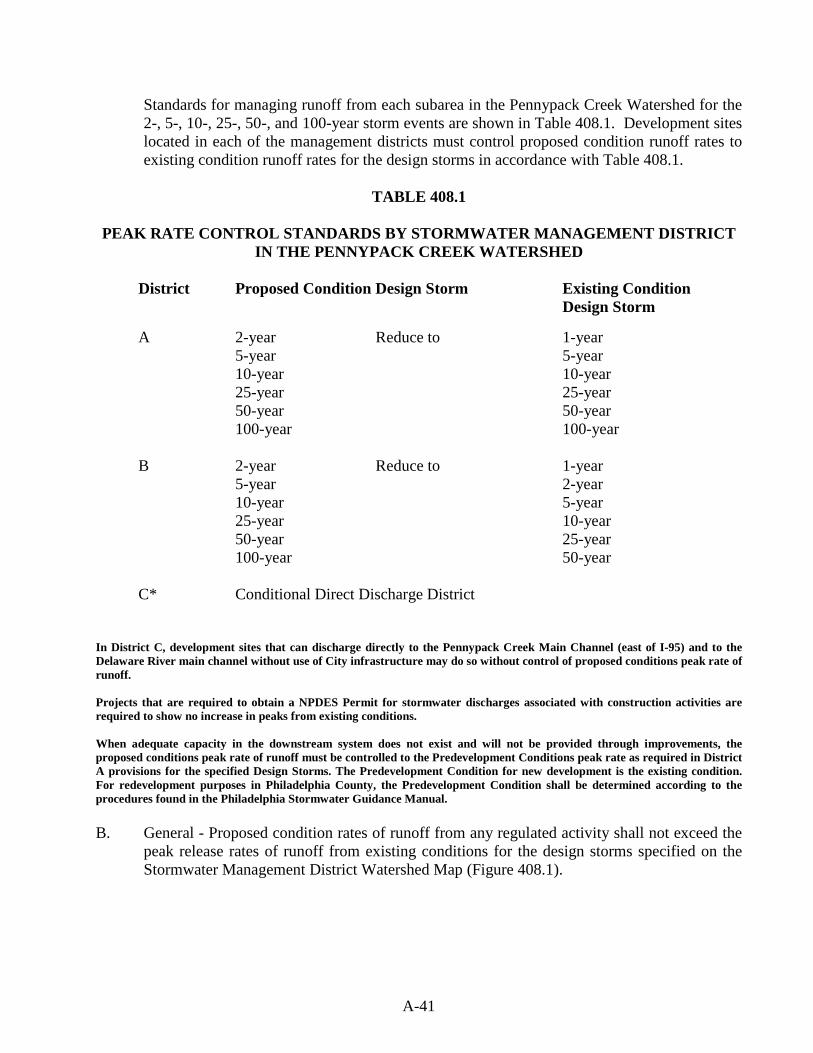
A-41
Standards for managing runoff from each subarea in the Pennypack Creek Watershed for the 2-, 5-, 10-, 25-, 50-, and 100-year storm events are shown in Table 408.1. Development sites located in each of the management districts must control proposed condition runoff rates to existing condition runoff rates for the design storms in accordance with Table 408.1.
TABLE 408.1
PEAK RATE CONTROL STANDARDS BY STORMWATER MANAGEMENT DISTRICT
IN THE PENNYPACK CREEK WATERSHED
District Proposed Condition Design Storm Existing Condition Design Storm
A 2-year Reduce to 1-year 5-year 5-year 10-year 10-year 25-year 25-year 50-year 50-year 100-year 100-year B 2-year Reduce to 1-year 5-year 2-year 10-year 5-year 25-year 10-year 50-year 25-year 100-year 50-year C* Conditional Direct Discharge District
In District C, development sites that can discharge directly to the Pennypack Creek Main Channel (east of I-95) and to the Delaware River main channel without use of City infrastructure may do so without control of proposed conditions peak rate of runoff. Projects that are required to obtain a NPDES Permit for stormwater discharges associated with construction activities are required to show no increase in peaks from existing conditions. When adequate capacity in the downstream system does not exist and will not be provided through improvements, the proposed conditions peak rate of runoff must be controlled to the Predevelopment Conditions peak rate as required in District A provisions for the specified Design Storms. The Predevelopment Condition for new development is the existing condition. For redevelopment purposes in Philadelphia County, the Predevelopment Condition shall be determined according to the procedures found in the Philadelphia Stormwater Guidance Manual. B. General - Proposed condition rates of runoff from any regulated activity shall not exceed the
peak release rates of runoff from existing conditions for the design storms specified on the Stormwater Management District Watershed Map (Figure 408.1).
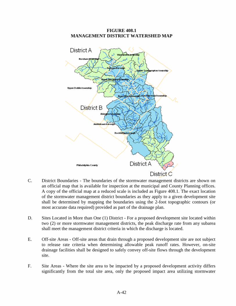
A-42
FIGURE 408.1 MANAGEMENT DISTRICT WATERSHED MAP
C. District Boundaries - The boundaries of the stormwater management districts are shown on
an official map that is available for inspection at the municipal and County Planning offices. A copy of the official map at a reduced scale is included as Figure 408.1. The exact location of the stormwater management district boundaries as they apply to a given development site shall be determined by mapping the boundaries using the 2-foot topographic contours (or most accurate data required) provided as part of the drainage plan.
D. Sites Located in More than One (1) District - For a proposed development site located within
two (2) or more stormwater management districts, the peak discharge rate from any subarea shall meet the management district criteria in which the discharge is located.
E. Off-site Areas - Off-site areas that drain through a proposed development site are not subject
to release rate criteria when determining allowable peak runoff rates. However, on-site drainage facilities shall be designed to safely convey off-site flows through the development site.
F. Site Areas - Where the site area to be impacted by a proposed development activity differs
significantly from the total site area, only the proposed impact area utilizing stormwater
A-43
management measures shall be subject to the management district criteria. In other words, unimpacted areas bypassing the stormwater management facilities would not be subject to the management district criteria.
G. Alternate Criteria for Redevelopment Sites - For redevelopment sites, one of the following
minimum design parameters shall be accomplished, whichever is most appropriate for the given site conditions as determined by [Municipality
];
1. Meet the full requirements specified by Table 408.1 and Sections 408.A through 408.F.
or
2. Reduce the total impervious surface on the site by at least twenty (20) percent based upon a comparison of existing impervious surface to proposed impervious surface.
Section 409. Calculation Methodology A. Stormwater runoff from all development sites with a drainage area of greater than 200 acres
shall be calculated using a generally accepted calculation technique that is based on the NRCS soil cover complex method. The Qualified Person must consult with the municipality to gain approval of design methods prior to design.
Table 409-1 summarizes acceptable computation methods and the method selected by the Qualified Person shall be based on the individual limitations and suitability of each method for a particular site. The Municipality may allow the use of the Rational Method to estimate peak discharges from drainage areas that contain less than 200 acres. The Soil Complex Method shall be used for drainage areas greater than 200 acres.

A-44
TABLE 409.1 Acceptable Computation Methodologies For
Stormwater Management Plans Bucks County and Montgomery County Portions of the Watershed
METHOD METHOD DEVELOPED BY APPLICABILITY
WINTR-20
USDA NRCS
Applicable where use of full hydrology computer model is
desirable or necessary.
WINTR-55 USDA NRCS
Applicable for land development plans within limitations described
in TR-55.
HEC-HMS US Army Corps of Engineers Applicable where use of full
hydrologic computer model is desirable or necessary.
Rational Method or commercial computer package based on Rational Method)
Emil Kuichling (1889)
For sites less than 200 acres and with time of concentration less
than 60 minutes (tc< 60 min), or as approved by the Municipality
and/or Municipal Engineer
Other Methods Varies Other computation methodologies
approved by the Municipality and/or Municipal Engineer.
Philadelphia County Portion of the Watershed
METHOD METHOD DEVELOPED BY APPLICABILITY
WINTR-20
USDA NRCS
Applicable where use of full hydrology computer model is
desirable or necessary.
WINTR-55 USDA NRCS
Applicable for land development plans within limitations described
in TR-55.
HEC-HMS US Army Corps of Engineers Applicable where use of full
hydrologic computer model is desirable or necessary.
SWMM 5 EPA
For single event or continuous simulation of runoff
quantity and quality from primarily urban areas.
*Note: Successors to the above methods are also acceptable. These successors include WinTR55
for TR-55 and WinTR20 for TR-20.
A-45
B. If a hydrologic computer model such as HydroCAD or HEC-HMS is used for stormwater runoff calculations, then the duration of rainfall shall be 24 hours. The rainfall distribution should reference NRCS Type II.
C. For the purposes of existing conditions flow rate determination, undeveloped land shall be
considered as "meadow" in good condition, unless the natural ground cover generates a lower curve number or Rational 'C' value (i.e., forest).
D. For Montgomery County only, all calculations using the Rational Method shall use rainfall
intensities from the NOAA 14 Precipitation-Frequency Atlas of the United States (2004, revised 2006). Times-of-concentration for overland flow shall be calculated using the methodology presented in Chapter 3 of Urban Hydrology for Small Watersheds, NRCS, TR-55 (as amended or replaced from time to time by NRCS). Times-of-concentration for channel and pipe flow shall be computed using flow velocities as determined by Manning's equation.
E. The Manning equation is preferred for 1-D, gradually-varied, open channel flow. In other
cases, appropriate, applicable methods should be applied, however, early coordination with the municipality is necessary.
F. Outlet structures for stormwater management facilities shall be designed to meet the performance standards of this Ordinance using the generally accepted hydraulic analysis technique or method of the Municipality.
G. The design of any stormwater detention facilities intended to meet the performance standards of this Ordinance shall be verified by routing the design storm hydrograph through these facilities using the Storage-Indication Method. For drainage areas greater than 200 acres in size, the design storm hydrograph shall be computed using a calculation method that produces a full hydrograph. The Municipality may approve the use of any generally accepted full hydrograph approximation technique that shall use a total runoff volume that is consistent with the volume from a method that produces a full hydrograph.
A-46
ARTICLE V - INSPECTIONS Section 501. Inspections A. The Municipality may inspect all phases of the installation of the Best Management Practices
(BMPs) and/or stormwater management facilities as deemed appropriate by the Municipality. B. During any stage of the work, if the Municipality determines that the BMPs and/or
stormwater management (SWM) facilities are not being installed in accordance with the approved SWM plan, the Municipality, may suspend or revoke, in whole or in part, any existing permits or other approvals and issue a cease and desist order until a revised SWM Site Plan is submitted and approved, as specified in this Ordinance, and until the deficiencies are corrected.
C. A final inspection of all BMPs and/or SWM facilities may be conducted by the Municipality
to confirm compliance with the approved Stormwater Management Site Plan prior to the issuance of any occupancy permit.
D. The developer shall be responsible for providing as-built plans of all SWM BMPs included
in the approved SWM Site Plan. The as-built plans and an explanation of any discrepancies, which were reviewed and received approval by the Municipality, shall be submitted to the Municipality.
E. The as-built submission shall include a certification of completion signed and sealed by a
Qualified Professional verifying that all permanent SWM BMPs have been constructed according to the approved plans and specifications. If any licensed Qualified Persons contributed to the construction plans, they must sign and seal the completion certificate.
F. Final plans based upon the as-builts (Record Drawings) must be received by the
Municipality prior to the issuance of the Certificate of Occupancy.
A-47
ARTICLE VI - FEES AND EXPENSES Section 601. Municipality SWM Site Plan Review and Inspection Fees Fees may be established by the Municipality to defray costs incurred by the Municipality. All fees shall be paid by the Applicant. A fee schedule shall be established by resolution of the municipal Governing Body, which may be based on the size of the Regulated Activity or the Municipality’s costs for processing SWM Site Plans and conducting inspections. The Municipality may periodically update the fee schedule to ensure that its costs are adequately reimbursed.
Section 602. Expenses Covered by Fees The fees authorized by this Ordinance may at a minimum cover: A. Administrative costs. B. Review of the SWM Site Plan by the Municipality. C. Site inspections. D. Inspection of SWM facilities and drainage improvements during construction. E. Final inspection at the completion of the construction of the SWM facilities and drainage
improvements presented in the SWM Site Plan. F. Any additional work required to enforce any permit provisions, correct violations, and assure
proper completion of necessary remedial actions.
A-48
ARTICLE VII - MAINTENANCE RESPONSIBILITIES Section 701. Performance Guarantee A. For subdivisions and land developments, the Applicant shall provide a financial guarantee to
the Municipality for the timely installation and proper construction of all stormwater management facilities as required by the approved SWM Site Plan. The amount of the guarantee shall be equal to or greater than the full construction cost of the required controls.
B. For other regulated activities, the Municipality may require a financial guarantee from the
Applicant.
Section 702. Responsibilities for Operation and Maintenance (O&M) of Stormwater Facilities and Best Management Practices (BMPs) A. The owner of any land upon which stormwater facilities and BMPs will be placed,
constructed, or implemented, as described in an O&M Plan, shall record the following documents in the Office of the Recorder of Deeds for ____________ County, within _______ (__) days of approval of the O&M plan by the Municipality:
1. The O&M Plan, or a summary thereof, 2. O&M Agreements under Section 704, and 3. Easements under Section 705.
B. The Municipality may suspend or revoke any approvals granted for the project site upon discovery of failure on the part of the owner to comply with this Ordinance.
C. The following items shall be included in the O&M Plan:
1. Map(s) of the project area, in a form that meets the requirements for recording at the offices of the Recorder of Deeds of _______________________County, shall be submitted on_______-inch x-_______inch sheets. The contents of the map(s) shall include, but not be limited to:
a. Clear identification of the location and nature of stormwater controls and
BMPs, b. The location of the project site relative to highways, municipal boundaries or
other identifiable landmarks, c. Existing and final contours at intervals of two (2) feet, or others as
appropriate, d. Existing streams, lakes, ponds, or other bodies of water within the project site
area, e. Other physical features including flood hazard boundaries, sinkholes, streams,
existing drainage courses, and areas of natural vegetation to be preserved, f. The locations of existing and proposed utilities, sanitary sewers, and water
lines within fifty (50) feet of property lines of the project site,
A-49
g. Proposed final changes to the land surface and vegetative cover, including the type and amount of impervious area that would be added,
h. Proposed final structures, roads, paved areas, and buildings, and i. A 15 feet wide access easement around all stormwater controls and BMPs that
would provide ingress to and egress from a public right-of-way.
2. A description of how each stormwater facility and BMP will be operated and maintained, and the identity and contact information associated with the person(s) responsible for operations and maintenance,
3. The name of the project site, the name and address of the owner of the property, and
the name of the individual or firm preparing the plan, and 4. A statement, signed by the landowner, acknowledging that the stormwater facilities
and BMPs are fixtures that cannot be altered or removed without prior approval by the Municipality.
D. The O&M Plan for the project site shall establish responsibilities for the continuing O&M of
all stormwater facilities and BMPs, as follows: 1. If a plan includes structures or lots that are to be separately owned and in which
streets, sewers, and other public improvements are to be dedicated to the Municipality, associated stormwater controls and BMPs also may be dedicated to and maintained by the Municipality;
2. If a plan includes operation and maintenance by a single ownership or if sewers and
other public improvements are to be privately owned and maintained, the O&M of stormwater controls and BMPs, and inspections required by permits, shall be the responsibility of the owner.
E. The Municipality will make the final determination on the continuing operation and
maintenance responsibilities prior to final approval of the Stormwater Management Site Plan. The Municipality reserves the right to accept or reject the O&M responsibility for any or all portions of the stormwater controls and BMPs.
F. The O&M Plan shall be recorded as a restrictive deed covenant that runs with the land. G. The municipality may take enforcement actions against an owner for any failure to satisfy the
provisions of this Article and this Ordinance.
Section 703. Municipal Review of an O&M Plan
A. O&M plans shall be consistent with the requirements of this Ordinance. B. The Municipality will notify Applicants in writing whether or not O&M plans are approved.
A-50
C. The Municipality’s approval letter will indicate whether or not “record drawings” of all stormwater controls and BMPs are required, including a final “as-built” O&M Plan.
Section 704. Operation and Maintenance (O&M) Agreement for Privately Owned Stormwater Controls and BMPs A. The owner shall sign an O&M agreement with the Municipality covering all stormwater
facilities and BMPs that are to be privately owned. The O&M agreement shall be transferred with transfer of ownership.
B. Other items may be included in the agreement where determined necessary to guarantee the
satisfactory operation and maintenance of all stormwater facilities and BMPs. The O&M Agreement shall be subject to the review and approval of the Municipality.
C. The owner is responsible for O&M of the SWM BMPs. If the owner fails to adhere to the
O&M Agreement, the Municipality may perform the services required and charge the owner appropriate fees. Nonpayment of fees may result in a lien against the property.
Section 705. Stormwater Management Easements A. The owner must obtain all necessary real estate rights to install, operate, and maintain all
stormwater facilities in the SWM Site Plan and the O&M Plan. B. The owner must provide the municipal easements, or other appropriate real estate rights, to
perform inspections and maintenance or the preservation of stormwater runoff conveyance, infiltration, and detention areas.

A-51
ARTICLE VIII - PROHIBITIONS Section 801. Prohibited Discharges and Connections A. Any drain or conveyance, whether on the surface or subsurface, that allows any non-
stormwater discharge, including sewage, process wastewater, or wash water to enter the separate storm sewer system, or otherwise to enter the waters of the Commonwealth is prohibited. Any connections to the storm drain system from indoor drains and sinks also are prohibited.
B. No person shall allow, or cause to allow, discharges into surface waters of this
Commonwealth which are not composed entirely of stormwater, except (1) as provided in subsection C below, and (2) discharges allowed under a state or federal permit.
C. The following discharges are authorized unless they are determined to be significant
contributors to pollution to the waters of this Commonwealth:
- Discharges from fire fighting activities - Flows from riparian habitats and wetlands
- Potable water sources including water line flushing
- Uncontaminated water from foundations or from footing drains
- Irrigation drainage - Lawn watering - Air conditioning condensate - Dechlorinated swimming pool
discharges - Springs - Uncontaminated groundwater - Water from crawl space pumps - Water from individual residential car
washing - Pavement wash waters where spills or
leaks of toxic or hazardous materials have not occurred (unless all spill material has been removed) and where detergents are not used
- Routine external building wash down (which does not use detergents or other compounds)
D. In the event that the Municipality or DEP determines that any of the discharges identified in
Subsection C significantly contribute to pollution of the waters of this Commonwealth, the Municipality or DEP will notify the responsible person(s) to cease the discharge.
Section 802. Roof Drains A. In Philadelphia, roof drains shall comply with Section P-1001 of the Philadelphia Plumbing
Code. B. In Bucks County and Montgomery County, roof drains shall not be connected to streets,
sanitary or storm sewers, or roadside ditches, and shall discharge to infiltration areas or vegetative BMPs to the maximum extent practicable.

A-52
Section 803. Alteration of BMPs A. No person shall modify, remove, fill, landscape, or alter any existing stormwater facility or
BMP unless it is part of an approved maintenance program and written approval of the Municipality has been obtained.
B. No person shall place any structure, fill, landscaping, or vegetation into a stormwater control
or BMP or within a drainage easement which would limit or alter the functioning of the stormwater control or BMP without the written approval of the Municipality.
A-53
ARTICLE IX - ENFORCEMENT AND PENALTIES Section 901. Right-of-Entry The Municipality, or its authorized agents and employees, will provide forty-eight (48) hours written notice when appropriate, at its sole discretion, and may then enter upon any part of the property within the Municipality to inspect and determine the compliance of the implementation, condition, or operation and maintenance (O&M) of the stormwater facilities or Best Management Practices (BMPs) in regard to any aspect governed by this Ordinance. Inspection includes monitoring and sampling to determine proper operation of stormwater facilities and BMPs. The Municipality shall have the right to temporarily locate on any stormwater control or BMP in the Municipality such devices as are necessary to conduct monitoring and/or sampling of the discharges from such stormwater control or BMP. Section 902. Inspection BMPs should be inspected for proper operation by the landowner, or the owner’s designee (including the municipality for dedicated and owned facilities), according to the following list of minimum frequencies:
1. Annually for the first 5 years. 2. Once every 3 years thereafter. 3. During or immediately after the cessation of a 10-year, 24-hour, or greater storm
event. 4. As specified in the O&M agreement,
Section 903. Enforcement All inspections regarding compliance with the Stormwater Management (SWM) Site Plan and this Ordinance shall be the responsibility of the Municipality. A. Whenever the Municipality finds that a person has violated a prohibition or failed to meet a
requirement of this Ordinance, the Municipality may order compliance by notifying the responsible person. Such notice may include the following remedies:
1. Performance of monitoring, analyses, and reporting; 2. Elimination of prohibited connections or discharges; 3. Cessation of any violating discharges, practices, or operations; 4. Abatement or remediation of stormwater pollution or contamination hazards and the
restoration of any affected property;
A-54
5. Payment of a fine to cover administrative and remediation costs; 6. Implementation of stormwater controls and BMPs; and 7. O&M of stormwater facilities and BMPs.
B. Such notification shall set forth the nature of the violation(s) and establish a time limit for correction of those violations(s). If the violator fails to take the required action within the established deadline, the work may be done by the Municipality and the expenses may be charged to the violator.
C. Failure to comply within the time specified may subject a violator to the penalty provisions
of this Ordinance. All such penalties shall be deemed cumulative and shall not prevent the Municipality from pursuing other remedies available in law or equity.
Section 904. Suspension and Revocation A. Any approval or permit issued by the municipality pursuant to this Ordinance may be
suspended or revoked for:
1. Non-compliance with or failure to implement any provision of the approved SWM Site Plan or O&M Agreement.
2. A violation of any provision of this Ordinance or any other applicable law, ordinance,
rule, or regulation relating to the Regulated Activity. 3. The creation of any condition or the commission of any act during the Regulated
Activity which constitutes or creates a hazard, nuisance, pollution, or endangers the life or property of others.
B. A suspended approval may be reinstated by the municipality when:
1. The municipality has inspected and approved the corrections to the violations that caused the suspension.
2. The municipality is satisfied that the violation has been corrected.
C. An approval that has been revoked by the municipality cannot be reinstated. The applicant may apply for a new approval under the provisions of this Ordinance.
D. If a violation causes no immediate danger to life, public health or safety, or property, at its
sole discretion, the municipality may provide a limited time period for the owner to correct the violation. In these cases, the municipality will provide the owner, or the owner’s designee, with a written notice of the violation and the time period allowed for the owner to
A-55
correct the violation. If the owner does not correct the violation within the allowed time period, the municipality may revoke or suspend any, or all, applicable approvals and permits pertaining to any provision of this Ordinance.
Section 905. Penalties (Municipalities should ask their solicitors to provide appropriate wording for this section.) A. Anyone violating the provisions of this Ordinance shall be guilty of a summary offense, and
upon conviction, shall be subject to a fine of not more than $________ for each violation, recoverable with costs. Each day that the violation continues shall be a separate offense and penalties shall be cumulative.
B. In addition, the municipality may institute injunctive, mandamus, or any other appropriate
action or proceeding at law or in equity for the enforcement of this Ordinance. Any court of competent jurisdiction shall have the right to issue restraining orders, temporary or permanent injunctions, mandamus, or other appropriate forms of remedy or relief.
Section 906. Appeals A. Any person aggrieved by any action of the municipality or its designee, relevant to the
provisions of this Ordinance, may appeal to the municipality within 30 days of that action. B. Any person aggrieved by any decision of the municipality, relevant to the provisions of this
Ordinance, may appeal to the County Court of Common Pleas in the county where the activity has taken place within 30 days of the municipality’s decision.

A-56
ENACTED and ORDAINED at a regular meeting of the ____________________ ___________________________ on the _____ of ______________________, 20__. This Ordinance shall take effect immediately. _________________________________________ [Name] _________________________________________ [Title] __________________________________________ [Name] __________________________________________ [Title] __________________________________________ [Name] __________________________________________ [Title] ________________________________________ [Name] ________________________________________ [Title] ________________________________________ [Name] ________________________________________ [Title] ATTEST: _________________________________ Secretary I hereby certify that the foregoing Ordinance was advertised in the _______________________________________ on __________, 20__, a newspaper of general circulation in the Municipality and was duly enacted and approved as set forth at a regular meeting of the Municipality’s Governing Body held on _____________, 20__. _____________________________ Secretary
A-57
SUBAPPENDIX A-1 SMALL PROJECT STORMWATER MANAGEMENT (SWM)
SITE PLAN This Small Project SWM Site Plan is included as an option for municipalities to adopt to give small regulated activities the opportunity to submit a non-engineered stormwater management plan. The requirements of this site plan alternative are consistent with the volume control requirements of the Pennypack Creek Watershed Stormwater Management Plan (SMP). This site plan can be applied only to development activities proposing less than 5,000 square feet of impervious surface and less than one acre of earth disturbance.
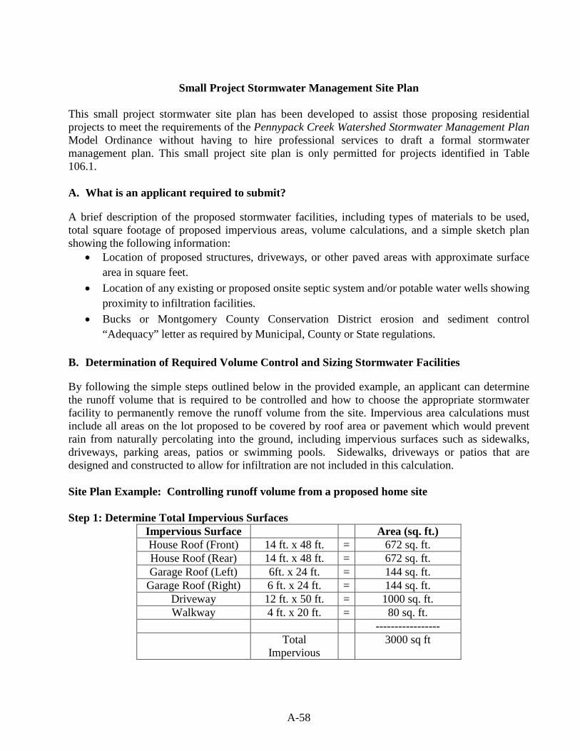
A-58
Small Project Stormwater Management Site Plan
This small project stormwater site plan has been developed to assist those proposing residential projects to meet the requirements of the Pennypack Creek Watershed Stormwater Management Plan Model Ordinance without having to hire professional services to draft a formal stormwater management plan. This small project site plan is only permitted for projects identified in Table 106.1. A. What is an applicant required to submit?
A brief description of the proposed stormwater facilities, including types of materials to be used, total square footage of proposed impervious areas, volume calculations, and a simple sketch plan showing the following information:
• Location of proposed structures, driveways, or other paved areas with approximate surface area in square feet.
• Location of any existing or proposed onsite septic system and/or potable water wells showing proximity to infiltration facilities.
• Bucks or Montgomery County Conservation District erosion and sediment control “Adequacy” letter as required by Municipal, County or State regulations.
B. Determination of Required Volume Control and Sizing Stormwater Facilities
By following the simple steps outlined below in the provided example, an applicant can determine the runoff volume that is required to be controlled and how to choose the appropriate stormwater facility to permanently remove the runoff volume from the site. Impervious area calculations must include all areas on the lot proposed to be covered by roof area or pavement which would prevent rain from naturally percolating into the ground, including impervious surfaces such as sidewalks, driveways, parking areas, patios or swimming pools. Sidewalks, driveways or patios that are designed and constructed to allow for infiltration are not included in this calculation. Site Plan Example: Controlling runoff volume from a proposed home site Step 1: Determine Total Impervious Surfaces
Impervious Surface Area (sq. ft.) House Roof (Front) 14 ft. x 48 ft. = 672 sq. ft. House Roof (Rear) 14 ft. x 48 ft. = 672 sq. ft. Garage Roof (Left) 6ft. x 24 ft. = 144 sq. ft.
Garage Roof (Right) 6 ft. x 24 ft. = 144 sq. ft. Driveway 12 ft. x 50 ft. = 1000 sq. ft. Walkway 4 ft. x 20 ft. = 80 sq. ft.
----------------- Total
Impervious 3000 sq ft
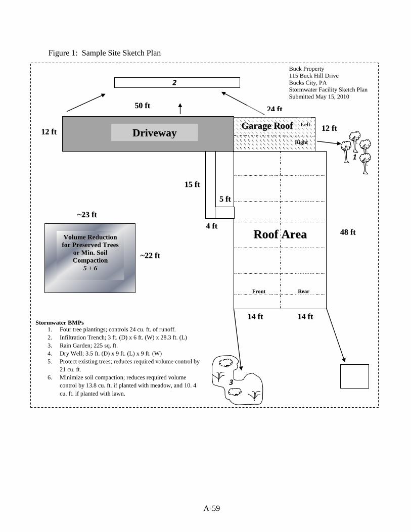
A-59
Buck Property 115 Buck Hill Drive Bucks City, PA Stormwater Facility Sketch Plan Submitted May 15, 2010
Stormwater BMPs 1. Four tree plantings; controls 24 cu. ft. of runoff. 2. Infiltration Trench; 3 ft. (D) x 6 ft. (W) x 28.3 ft. (L) 3. Rain Garden; 225 sq. ft. 4. Dry Well; 3.5 ft. (D) x 9 ft. (L) x 9 ft. (W) 5. Protect existing trees; reduces required volume control by
21 cu. ft. 6. Minimize soil compaction; reduces required volume
control by 13.8 cu. ft. if planted with meadow, and 10. 4 cu. ft. if planted with lawn.
Figure 1: Sample Site Sketch Plan
1122 fftt
2
5500 fftt 2244 fftt
GGaarraaggee RRooooff Left
Right DDrriivveewwaayy 1122 fftt
1
4488 fftt
1144 fftt 1144 fftt
RRooooff AArreeaa
Front Rear
1155 fftt
44 fftt
55 fftt
~~2233 fftt
~~2222 fftt
VVoolluummee RReedduuccttiioonn ffoorr PPrreesseerrvveedd TTrreeeess
oorr MMiinn.. SSooiill CCoommppaaccttiioonn
55 ++ 66
3
4
A-60
Step 2: Determine Required Volume Control (cubic feet) using the following equation:
Volume (cu. ft.) = (Total impervious area in square feet x 2 inches of runoff) /12 inches
(3,000 sq. ft. x 2 inches of runoff) /12 inches = 500 cu. ft.
Step 3: Sizing the Selected Volume Control BMP Several Best Management Practices (BMPs), as described below, are suitable for small stormwater management projects. However, their application depends on the volume required to be controlled, how much land is available, and the site constraints. Proposed residential development activities can apply both non-structural and structural BMPs to control the volume of runoff from the site. A number of different volume control BMPs are described below. Note that Figure 1 is an example of how these BMPs can be utilized in conjunction to control the total required volume on one site. Structural BMPs 1. Infiltration Trench
An Infiltration Trench is a linear stormwater BMP consisting of a continuously perforated pipe at a minimum slope in a stone-filled trench. During small storm events, infiltration trenches can significantly reduce volume and serve in the removal of fine sediments and pollutants. Runoff is stored between the stones and infiltrates through the bottom of the facility and into the soil matrix. Runoff should be pretreated using vegetative buffer strips or swales to limit the amount of coarse sediment entering the trench which can clog and render the trench ineffective. In all cases, an infiltration trench should be designed with a positive overflow. Design Considerations:
• Although the width and depth can vary, it is recommended that Infiltration Trenches be limited in depth to not more than six (6) feet of stone.
• Trench is wrapped in nonwoven geotextile (top, sides, and bottom). • Trench needs to be placed on uncompacted soils. • Slope of the Trench bottom should be level or with a slope no greater than 1%. • A minimum of 6" of topsoil is placed over trench and vegetated. • The discharge or overflow from the Infiltration Trench should be properly designed for
anticipated flows. • Cleanouts or inlets should be installed at both ends of the Infiltration Trench and at
appropriate intervals to allow access to the perforated pipe. • Volume of facility = Depth x Width x Length x Void Space of the gravel bed (assume 40%).
Maintenance:
• Catch basins and inlets should be inspected and cleaned at least two times a year. • The vegetation along the surface of the infiltration trench should be maintained in good
condition and any bare spots should be re-vegetated as soon as possible.
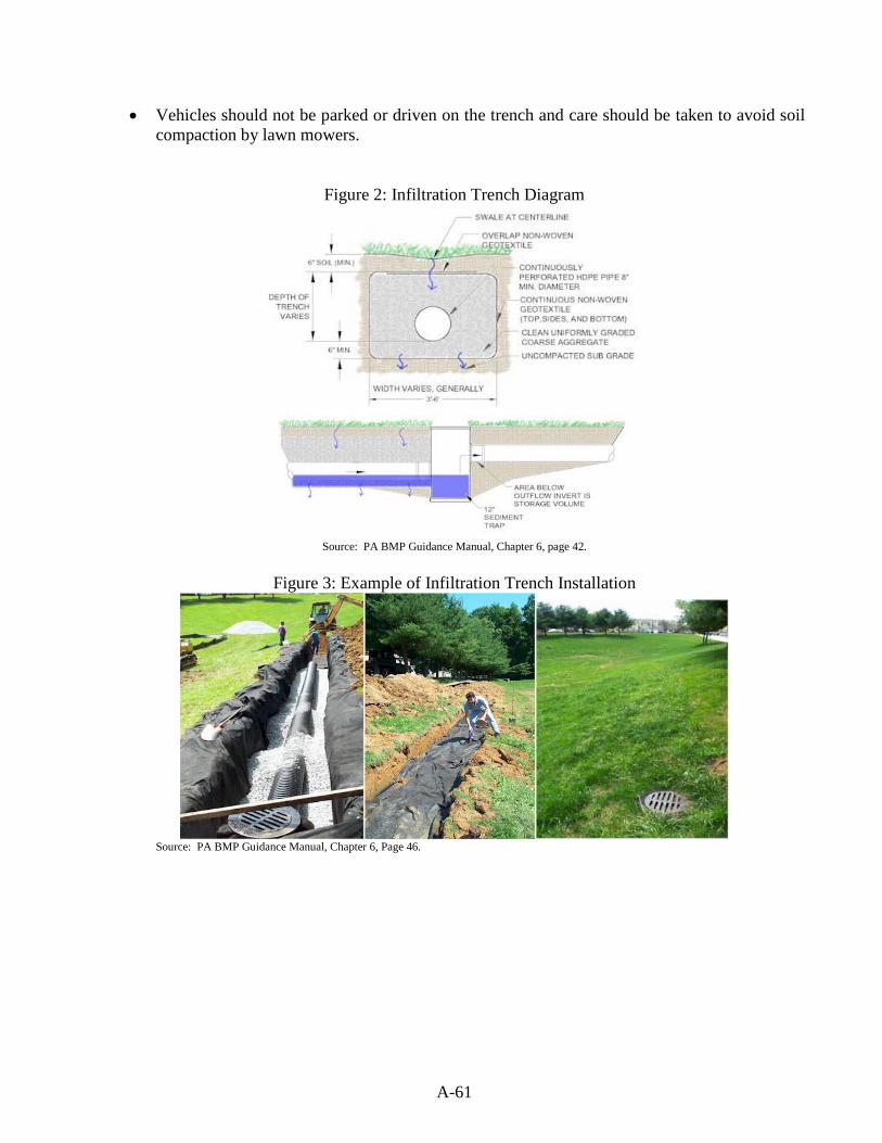
A-61
• Vehicles should not be parked or driven on the trench and care should be taken to avoid soil compaction by lawn mowers.
Figure 2: Infiltration Trench Diagram
Source: PA BMP Guidance Manual, Chapter 6, page 42.
Figure 3: Example of Infiltration Trench Installation
Source: PA BMP Guidance Manual, Chapter 6, Page 46.
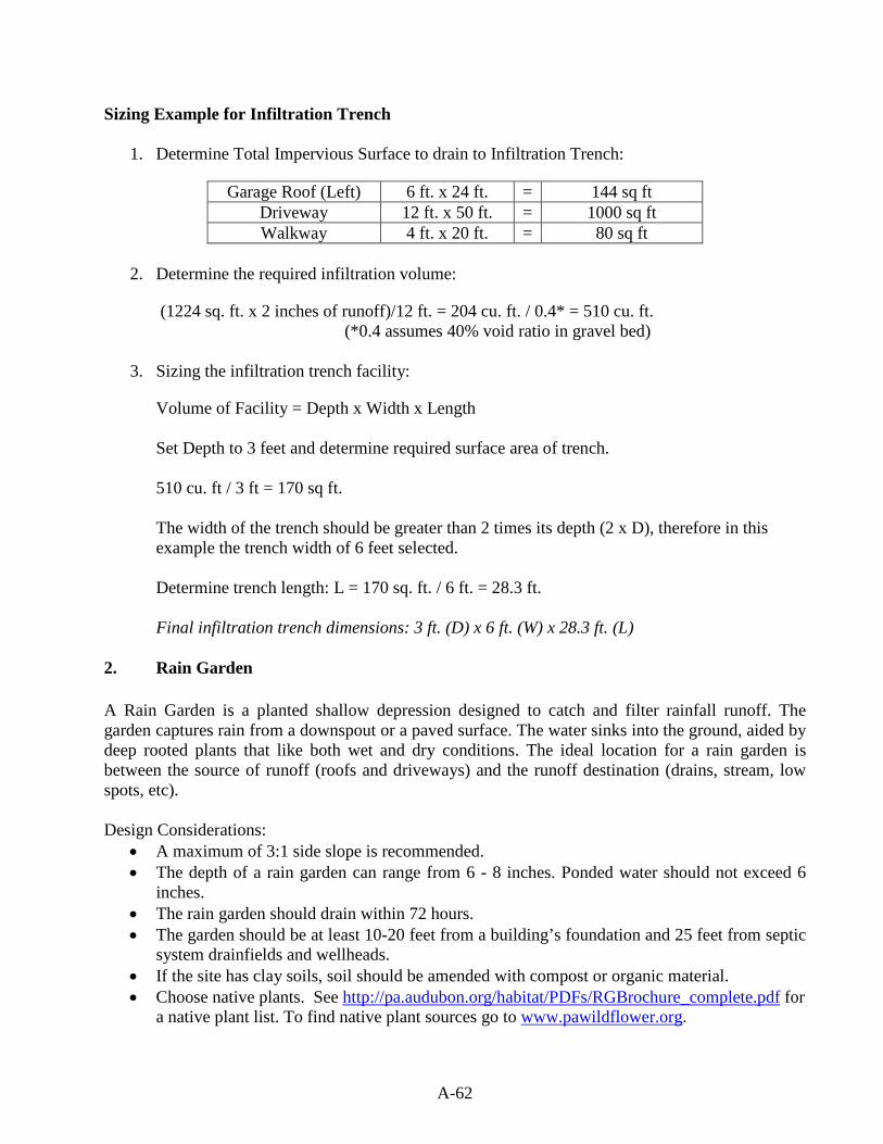
A-62
Sizing Example for Infiltration Trench
1. Determine Total Impervious Surface to drain to Infiltration Trench:
Garage Roof (Left) 6 ft. x 24 ft. = 144 sq ft Driveway 12 ft. x 50 ft. = 1000 sq ft Walkway 4 ft. x 20 ft. = 80 sq ft
2. Determine the required infiltration volume:
(1224 sq. ft. x 2 inches of runoff)/12 ft. = 204 cu. ft. / 0.4* = 510 cu. ft. (*0.4 assumes 40% void ratio in gravel bed)
3. Sizing the infiltration trench facility:
Volume of Facility = Depth x Width x Length Set Depth to 3 feet and determine required surface area of trench. 510 cu. ft / 3 ft = 170 sq ft. The width of the trench should be greater than 2 times its depth (2 x D), therefore in this example the trench width of 6 feet selected. Determine trench length: L = 170 sq. ft. / 6 ft. = 28.3 ft. Final infiltration trench dimensions: 3 ft. (D) x 6 ft. (W) x 28.3 ft. (L)
2. Rain Garden
A Rain Garden is a planted shallow depression designed to catch and filter rainfall runoff. The garden captures rain from a downspout or a paved surface. The water sinks into the ground, aided by deep rooted plants that like both wet and dry conditions. The ideal location for a rain garden is between the source of runoff (roofs and driveways) and the runoff destination (drains, stream, low spots, etc). Design Considerations:
• A maximum of 3:1 side slope is recommended. • The depth of a rain garden can range from 6 - 8 inches. Ponded water should not exceed 6
inches. • The rain garden should drain within 72 hours. • The garden should be at least 10-20 feet from a building’s foundation and 25 feet from septic
system drainfields and wellheads. • If the site has clay soils, soil should be amended with compost or organic material. • Choose native plants. See http://pa.audubon.org/habitat/PDFs/RGBrochure_complete.pdf for
a native plant list. To find native plant sources go to www.pawildflower.org.
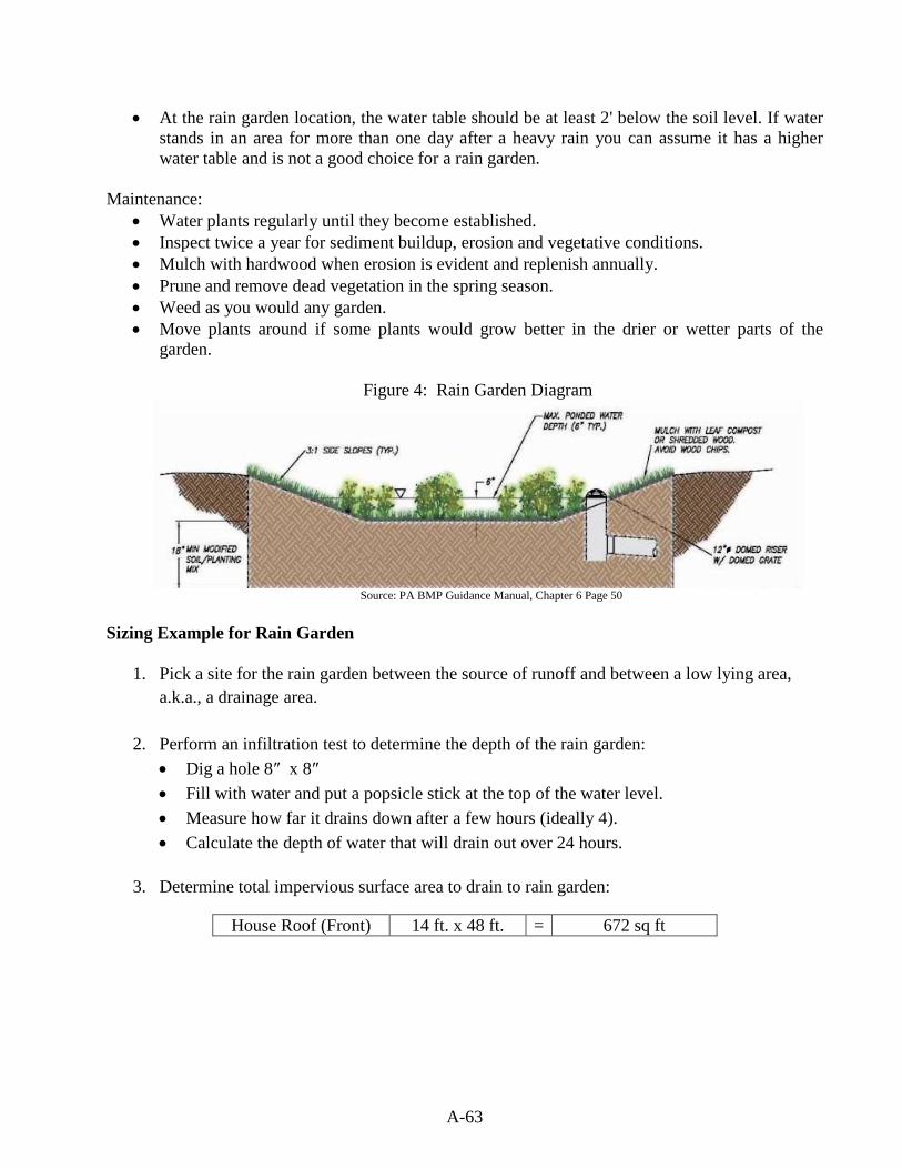
A-63
• At the rain garden location, the water table should be at least 2' below the soil level. If water stands in an area for more than one day after a heavy rain you can assume it has a higher water table and is not a good choice for a rain garden.
Maintenance:
• Water plants regularly until they become established. • Inspect twice a year for sediment buildup, erosion and vegetative conditions. • Mulch with hardwood when erosion is evident and replenish annually. • Prune and remove dead vegetation in the spring season. • Weed as you would any garden. • Move plants around if some plants would grow better in the drier or wetter parts of the
garden.
Figure 4: Rain Garden Diagram
Source: PA BMP Guidance Manual, Chapter 6 Page 50
Sizing Example for Rain Garden
1. Pick a site for the rain garden between the source of runoff and between a low lying area, a.k.a., a drainage area.
2. Perform an infiltration test to determine the depth of the rain garden: • Dig a hole 8″ x 8″ • Fill with water and put a popsicle stick at the top of the water level. • Measure how far it drains down after a few hours (ideally 4). • Calculate the depth of water that will drain out over 24 hours.
3. Determine total impervious surface area to drain to rain garden:
House Roof (Front) 14 ft. x 48 ft. = 672 sq ft
A-64
4. Sizing the rain garden: For this example the infiltration test determined 6″ of water drained out of a hole in 24 hours. The depth of the rain garden should be set to the results of the infiltration test so 6″ is the depth of the rain garden. The sizing calculation below is based on controlling 1″ of runoff. First divide the impervious surface by the depth of the rain garden.
(672 sq ft / 6 ft.) = 112 sq. ft.
In order to control 2″ of runoff volume, the rain garden area needs to be multiplied by 2.
112 sq. ft. * 2 = 224 sq. ft.
The rain garden should be about 225 sq. ft. in size and 6″ deep. 3. Dry Well (a.k.a., Seepage Pit)
A Dry Well, sometimes called a Seepage Pit, is a subsurface storage facility that temporarily stores and infiltrates stormwater runoff from the roofs of structures. By capturing runoff at the source, Dry Wells can dramatically reduce the increased volume of stormwater generated by the roofs of structures. Roof leaders connect directly into the Dry Well, which may be either an excavated pit filled with uniformly graded aggregate wrapped in geotextile, or a prefabricated storage chamber or pipe segment. Dry Wells discharge the stored runoff via infiltration into the surrounding soils. In the event that the Dry Well is overwhelmed in an intense storm event, an overflow mechanism (surcharge pipe, connection to a larger infiltration are, etc.) will ensure that additional runoff is safely conveyed downstream. Design Considerations:
• Dry Wells typically consist of 18 to 48 inches of clean washed, uniformly graded aggregate with 40% void capacity (AASHTO No. 3, or similar). “Clean” gravel fill should average one and one-half to three (1.5 – 3.0) inches in diameter.
• Dry Wells are not recommended when their installation would create a significant risk for basement seepage or flooding. In general, 10 - 20 feet of separation is recommended between Dry Wells and building foundations.
• The facility may be either a structural prefabricated chamber or an excavated pit filled with aggregate.
• Depth of dry wells in excess of three-and-a-half (3.5) feet should be avoided unless warranted by soil conditions.
• Stormwater dry wells must never be combined with existing, rehabilitated, or new septic system seepage pits. Discharge of sewage to stormwater dry wells is strictly prohibited.
Maintenance: • Dry wells should be inspected at least four (4) times annually as well as after large storm
events. • Remove sediment, debris/trash, and any other waste material from a dry well. • Regularly clean out gutters and ensure proper connections to the dry well.
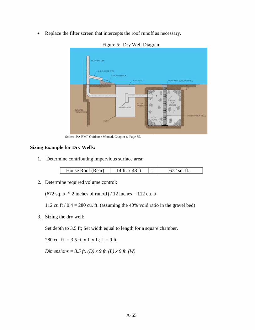
A-65
• Replace the filter screen that intercepts the roof runoff as necessary.
Figure 5: Dry Well Diagram
Source: PA BMP Guidance Manual, Chapter 6, Page 65.
Sizing Example for Dry Wells:
1. Determine contributing impervious surface area:
House Roof (Rear) 14 ft. x 48 ft. = 672 sq. ft.
2. Determine required volume control: (672 sq. ft. * 2 inches of runoff) / 12 inches = 112 cu. ft.
112 cu ft / 0.4 = 280 cu. ft. (assuming the 40% void ratio in the gravel bed)
3. Sizing the dry well:
Set depth to 3.5 ft; Set width equal to length for a square chamber.
280 cu. ft. = 3.5 ft. x L x L; L = 9 ft.
Dimensions = 3.5 ft. (D) x 9 ft. (L) x 9 ft. (W)
A-66
Non-Structural BMPs 1. Tree Plantings and Preservation Trees and forests reduce stormwater runoff by capturing and storing rainfall in the canopy and releasing water into the atmosphere through evapotranspiration. Tree roots and leaf litter also create soil conditions that promote the infiltration of rainwater into the soil. In addition, trees and forests reduce pollutants by taking up nutrients and other pollutants from soils and water through their root systems. A development site can reduce runoff volume by planting new trees or by preserving trees which existed on the site prior to development. The volume reduction calculations either determine the cubic feet to be directed to the area under the tree canopy for infiltration or determine a volume reduction credit which can be used to reduce the size of any one of the planned structural BMPs on the site. Tree Considerations:
• Existing trees must have at least a 4″ trunk caliper or larger. • Existing tree canopy must be within 100 ft. of impervious surfaces. • A tree canopy is classified as the continuous cover of branches and foliage formed by a
single tree or collectively by the crowns of adjacent trees. • New tree plantings must be at least 6 ft. in height and have a 2″ trunk caliper. • All existing and newly planted trees must be native to Pennsylvania. See
http://www.dcnr.state.pa.us/forestry/commontr/commontrees.pdf for a guide book titled Common Trees of Pennsylvania for a native tree list.
• When using trees as volume control BMPs, runoff from impervious areas should be directed to drain under the tree canopy.
Determining the required number of planted trees to reduce the runoff volume:
1. Determine contributing impervious surface area:
Garage Roof (Right) 6 ft. x 24 ft. = 144 ft
2. Calculate the required control volume:
(144 sq. ft. x 2 inches of runoff) / 12 inches = 24 cu. ft.
3. Determine the number of tree plantings:
• A newly planted deciduous tree can reduce runoff volume by 6 cu. ft. • A newly planted evergreen tree can reduce runoff volume by 10 cu. ft.
24 cu. ft./ 6 cu. ft. = 4 Deciduous Trees
Determining the volume reduction for preserving existing trees:
A-67
1. Calculate approximate area of the existing tree canopy: ~22 sq. ft. x ~23 sq. ft = 500 sq. ft.
2. Measure distance from impervious surface to tree canopy: 35 ft.
3. Calculate the volume reduction credit by preserving existing trees:
• For Trees within 20 feet of impervious cover: Volume Reduction cu. ft. = (Existing Tree Canopy sq. ft. x 1 inch) / 12
• For Trees beyond 20 feet but not farther than 100 feet from impervious cover: Volume Reduction cu. ft. = (Existing Tree Canopy sq. ft. x 0.5 inch) / 12
(500 sq. ft. x 0.5 inches) / 12 = 21 cu. ft. This volume credit can be utilized in reducing the size of any one of the structural BMPs planned on the site. For example, the 21 cu. ft. could be subtracted from the required infiltration volume when sizing the infiltration trench;
510 cu. ft – 21 cu. ft. = 489 cu. ft.
489 cu. ft. / 3 ft (Depth) = 163 / 6 ft. (Width) = 27.1 ft (Length)
Using the existing trees for a volume credit would decrease the length of the infiltration trench to 27.1 ft. instead of 28.3 ft.
2. Minimize Soil Compaction and Replant with Lawn or Meadow
When soil is overly compacted during construction it can cause a drastic reduction in the permeability of the soil and rarely is the soil profile completely restored. Runoff from vegetative areas with highly compacted soils similarly resembles runoff from an impervious surface. Minimizing soil compaction and re-planting with a vegetative cover like meadow or lawn, not only increases the infiltration on the site, but also creates a friendly habitat for a variety of wildlife species. Design Considerations:
• Area shall not be stripped of topsoil. • Vehicle movement, storage, or equipment/material lay down shall not be permitted in
areas preserved for minimum soil compaction. • The use of soil amendments and additional topsoil is permitted. • Meadow should be planted with native grasses. Refer to Meadows and Prairies:
Wildlife-Friendly Alternatives to Lawn at http://pubs.cas.psu.edu/FreePubs/pdfs/UH128.pdf for reference on how to properly plant the meadow and for a list of native species.
A-68
Determining the volume reduction by minimizing soil compaction and planting a meadow:
1. Calculate approximate area of preserved meadow:
~22 sq. ft. x ~23 sq. ft = 500 sq. ft.
2. Calculate the volume reduction credit by minimizing the soil compaction and planting a lawn/meadow:
• For Meadow Areas: Volume Reduction (cu. ft.) = (Area of Min. Soil Compaction (sq.
ft.) x 1/3 inch of runoff) / 12 (500 sq. ft. x 1/3 inch of runoff) / 12 = 13.8 cu. ft.
• For Lawn Areas: Volume Reduction (cu. ft.) = (Area of Min. Soil Compaction (sq.
ft.) x 1/4 inch of runoff) / 12 (500 sq. ft. x 1/4 inch of runoff) / 12 = 10.4 cu. ft.
This volume credit can be used to reduce the size of any one of the structural BMPs on the site. See explanation under the volume credit for preserving existing trees for details. Alternative BMP to Capture and Reuse Stormwater Rain Barrels Rain barrels are large containers that collect drainage from roof leaders and temporarily store water to be released to lawns, gardens, and other landscaped areas after the rainfall has ended. Rain barrels are typically between 50 and 200 gallons in size. It is not recommended for rain barrels to be used as a volume control BMP because infiltration is not guaranteed after each storm event. For this reason, a rain barrel is not utilized in the site plan example. However, the information is included to provide an alternative for a homeowner to utilize when considering capture and reuse stormwater methods. Design Considerations:
• Rain barrels should be directly connected to the roof gutter/spout. • There must be a means to release the water stored between storm events to provide the
necessary storage volume for the next storm. • When calculating rain barrel size, rain barrels are typically assumed to be 25% full because
they are not always emptied before the next storm. • Use screens to filter debris and cover lids to prevent mosquitoes. • An overflow outlet should be placed a few inches below the top with an overflow pipe to
divert flow away from structures. • It is possible to use a number of rain barrels jointly for an area.

A-69
Figure 6: Rain Barrel Diagram and Examples
Sources: (top picture) http://www.citywindsor.ca/DisplayAttach.asp?AttachID=12348 (bottom picture on left) http://repurposinglife.blogspot.com/2009/05/rainwater-harvesting.html
(bottom picture on right) http://www.floridata.com/tracks/transplantedgardener/Rainbarrels.cfm Sizing Example for a Rain Barrel
1. Determine contributing impervious surface area:
Garage Roof (Right) 6 ft. x 24 ft. = 144 sq ft
2. Determine the amount of rainfall to be captured by the Rain Barrel. A smaller storm, no more than 2″, is recommended to calculate the runoff to be captured . This example chose the 1″ storm event.
3. Calculate the volume to be captured and reused:
(144 sq. ft. x 1 inch of runoff ) / 12 inches = 12 cu. ft.

A-70
4. Size the rain barrel: 1 cu. ft. = 7. 48 gallons 12 cu. ft. x 7.48 = 90 gallons 90 gallons x (0.25*) = 22.5 gallons (*assuming that the rain barrel is always at least 25% full) 90 gallons + 22.5 gallons = 112 gallons The rain barrel or barrels should be large enough to hold at least 112 gallons of water.
REFERENCES: Center for Watershed Protection and US Forest Service. (2008). Watershed Forestry Resource
Guide. Retrieved on May 26, 2010 from http://www.forestsforwatersheds.org/reduce-stormwater/.
Department of Environmental Protection. (2006). Pennsylvania Stormwater Best Management
Practices Manual. Wissahickon Watershed Partnership. Pennsylvania Rain Garden Guide. Retrieved on May 4, 2010
from http://pa.audubon.org/habitat/PDFs/RGBrochure_complete.pdf. Building a Backyard Rain Garden. North Carolina Cooperative Extension. Retrieved on May 4,
2010 from http://www.bae.ncsu.edu/topic/raingarden/Building.htm Delaware County Planning Commission. (2010). Draft Crum Creek Watershed Act 167 Stormwater
Management Plan. Ordinance Appendix B. Simplified Approach to Stormwater Management for Small Projects.
Solebury Township. (2008). Solebury Township Stormwater Management Ordinance. “Appendix J
Simplified Stormwater Management Procedures for Existing Single Family Dwelling Lots”
A-71
SUBAPPENDIX A-2 NONSTRUCTURAL PROJECT DESIGN CHECKLIST
The goal of this checklist is to minimize the increases in stormwater runoff and impacts to water quality resulting from the proposed regulated activity:
1. Prepare an Existing Resource and Site Analysis Map (ERSAM, see Section 301.B.) 2. Establish a stream buffer according to Section 407. 3. Prepare a draft project layout avoiding sensitive areas identified in Section 301. 4. Identify site-specific existing conditions drainage areas, discharge points, recharge areas,
and hydrologic soil groups A and B (areas conducive to infiltration). 5. Evaluate nonstructural stormwater management alternatives (Section 404):
a) Minimize earth disturbance. b) Minimize clearing operations (vegetation removal) c) Minimize impervious surfaces. d) Break up large impervious surfaces.
6. Satisfy the groundwater recharge (infiltration) objective (Section 405) and provide for stormwater pretreatment prior to infiltration.
7. Provide for water quality protection in accordance with Section 406 water volume control requirements.
8. Provide stream bank erosion protection in accordance with Section 407 stream bank erosion requirements.
9. Determine into what management district the site falls (Section 408) and conduct an existing conditions runoff analysis.
10. Prepare final project design to maintain existing conditions drainage areas and discharge points, to minimize earth disturbance and impervious surfaces, and, to the maximum extent possible, to ensure that the remaining site development has no surface or point discharge.
11. Conduct a proposed conditions runoff analysis based on the final design that meets the management district requirements (Section 408).
12. Manage any remaining runoff prior to discharge through detention, bioretention, direct discharge, or other structural control.
A-72
SUBAPPENDIX A-3 RIPARIAN BUFFER TRAIL GUIDELINES
[Note to Municipality: The following riparian buffer trail guidelines may be modified provided that the buffer meets all minimum width and vegetation requirements detailed in Section 407 of the ordinance as well as all federal, state and local, stormwater, floodplain, and other requirements and regulations.] Introduction Riparian buffers are used as non-structural best management practices (BMPs) for protecting and enhancing water quality. Depending on their size, location, and design, riparian buffers often supply additional environmental, economic, aesthetic, and recreational value. Passive recreational trails can be a compatible use within riparian buffers if the trails are sized and placed appropriately. The trail guidelines below are meant to supplement Section 406, Water Volume Control Requirements, and do not alter or modify the regulations set forth in Section 401, General Requirements. All other applicable rules and requirements should be followed, including all federal, state, permitting, and local stormwater and floodplain ordinances. Installing a trail does not relieve a developer or municipality of the minimum buffer and vegetation requirements described in Section 407, or infiltration and peak rate controls in Sections 405 and 408. Effort shall be made to mitigate water quality and peak rate adjacent the trail structure to avoid collecting runoff in a large facility and creating a point discharge. This can be accomplished by trail-side stone filtration trenches, vegetative filter strips, small bio-retention facilities, and other mechanisms subject to site constraints and municipal engineer approval. See Figure 2-1. In situations where site constraints negate the feasibility of trail-side mitigation methods, effort shall be made to collect runoff in multiple stormwater facilities for segmented portions of the trail, in place of detaining stormwater in one large facility. Level spreaders shall be constructed at facility outlets to decrease point-source discharges. As with all trails, adequate land acquisition, easements, and/or landowner permission should be obtained in advance of any trail placement. Care should be given when designing and installing trails so as not to compromise the buffer’s ability to protect water quality. Many factors such as slope, vegetation, and soil type will determine the type, size, and placement of the trail within the riparian buffer. Heavily used trails and trails with wide impervious surfaces should be set back farther from the stream edge to help mitigate the effects of any associated increase in runoff. Note: failure to comply with these guidelines (Installing a trail with inadequate setback from the stream bank) could result in increased stormwater runoff, decreased water quality, stream bank degradation, and damage to the buffer or trail.
A-73
Trail Recommendations Location, Size, and Orientation All trails should be a reasonable width appropriate for the site conditions. It is not recommended that the width of any paved trail exceed twenty five (25) percent of the total buffer width. All trail designs and specifications are subject to approval by the Municipality. Natural vegetation must be present throughout the buffer as described in Section 407 of the ordinance. Grassy areas should be managed as meadows or be reforested and should not be mowed as lawn in any part of the buffer. Where existing vegetation is insufficient to protect water quality, additional native species should be planted to enhance the buffer. Paved trails, if appropriate to the site, are permitted and must be located at least twenty-five (25) feet from the top of the stream bank. In limited instances, paved trails be placed closer to a stream due to topography, or in order to accommodate passive educational and recreational activities, but must always be at least ten (10) feet from the top of the stream bank. Although this can be achieved by diverting the entire trail closer to the stream, more conservative methods should be considered, such as smaller spur trails or loop trails. These smaller trails provide access to the stream, but reduce the total traffic along the sensitive stream bank. In rare instances where the buffer width is reduced due to zoning setback or geographical constraints, the municipality should strongly consider whether the benefits of a trail outweigh the benefits of a wider buffer. Signage The installation of interpretive and educational signage is strongly encouraged along the trail. Signs should point out local natural resources and educate the public on how riparian buffers protect the watershed. There should be minimum disturbance in the vegetated buffer between the trail and the stream. Therefore, all appurtenances (e.g. benches, educational signs, kiosks, fountains, etc.) should be installed on the landward side of the trail, if possible. All appurtenances shall be installed in compliance with federal, state, local, stormwater, floodplain, and other regulations and permitting requirements (e.g. anchoring, etc.) Parking Areas New trailheads and trail parking areas shall meet all the infiltration, rate control, and minimum setback requirements of this ordinance. Every effort should be made to coordinate trail access with existing parking areas. Any new parking areas and trailhead clearings should not encroach on the riparian buffer in any way. Trail Maintenance The installation and maintenance of all trails should be performed in a manner that minimizes site disturbance and prevents runoff and erosion. Soil disturbance should be avoided if possible. The

A-74
removal of native trees and other native vegetation should also be kept to a minimum. If large or heavy equipment is required for trail installation, special care should be given not to damage existing trees and tree roots.
FIGURE 3-1
EXAMPLE DESIGN OF A TRAIL-SIDE STONE FILTRATION TRENCH
Source: James MacCombie, Herbert E. MacCombie Jr. P.E. Consulting Engineers & Surveyors Inc.


