PENNSYLVANIA GAME COMMISSION SGL #48 SCRUB OAK ROAD ...
64
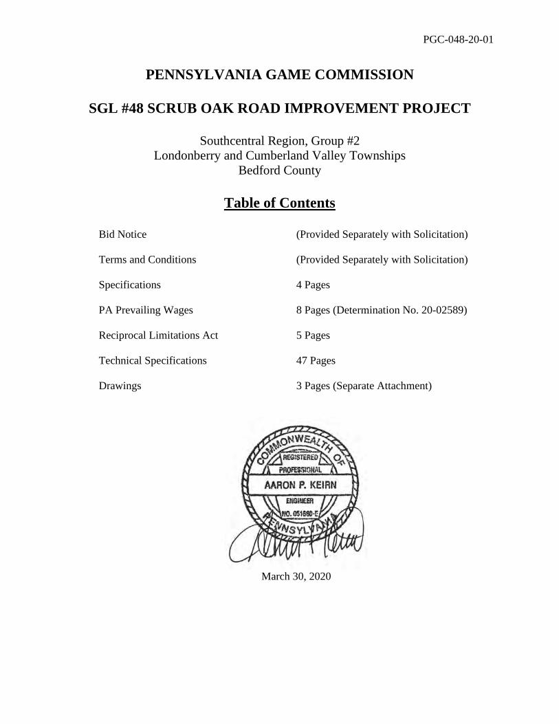
PGC-048-20-01 PENNSYLVANIA GAME COMMISSION SGL #48 SCRUB OAK ROAD IMPROVEMENT PROJECT Southcentral Region, Group #2 Londonberry and Cumberland Valley Townships Bedford County Table of Contents Bid Notice (Provided Separately with Solicitation) Terms and Conditions (Provided Separately with Solicitation) Specifications 4 Pages PA Prevailing Wages 8 Pages (Determination No. 20-02589) Reciprocal Limitations Act 5 Pages Technical Specifications 47 Pages Drawings 3 Pages (Separate Attachment) March 30, 2020
Transcript of PENNSYLVANIA GAME COMMISSION SGL #48 SCRUB OAK ROAD ...
PGC-048-20-01
PENNSYLVANIA GAME COMMISSION
SGL #48 SCRUB OAK ROAD IMPROVEMENT PROJECT
Southcentral Region, Group #2 Londonberry and Cumberland Valley Townships
Bedford County
Table of Contents
Bid Notice (Provided Separately with Solicitation) Terms and Conditions (Provided Separately with Solicitation) Specifications 4 Pages PA Prevailing Wages 8 Pages (Determination No. 20-02589) Reciprocal Limitations Act 5 Pages Technical Specifications 47 Pages Drawings 3 Pages (Separate Attachment)
March 30, 2020

SGL #48 SCRUB OAK ROAD IMPROVEMENTS PGC-048-20-01
Page 1 of 4
PROJECT SPECIFICATIONS The Contractor shall comply with the Contract Terms and Conditions provided with the Bid Documents including but not limited to the following: INSURANCE REQUIREMENTS – In accordance with the Contract Terms and Conditions, the Contractor is required to have in place during the term of the Contract and any renewals or extensions thereof, the following types of insurance, issued by companies acceptable to the Commonwealth and authorized to conduct such business under the laws of the Commonwealth of Pennsylvania:
A. Worker's Compensation Insurance for all of the Contractor's employees and those of any subcontractor, engaged in work at the site of the project as required by law.
B. Public Liability and Property Damage Insurance to protect the
Commonwealth, the Contractor, and any and all subcontractors from claims for damages for personal injury (including bodily injury), sickness or disease, accidental death and damage to property including the loss of use resulting from any property damage, which may arise from the activities performed under the Contract or the failure to perform under the Contract, whether such performance or non-performance be by the Contractor, by any subcontractor, or by anyone directly or indirectly employed by either. The minimum amounts of coverage shall be $250,000 per person and $1,000,000 per occurrence for bodily injury, including death, and $250,000 per person and $1,000,000 per occurrence for property damage. Such policies shall be occurrence rather than claims-made policies and shall not contain any endorsements or any other form designated to limit and restrict any action by the Commonwealth, as an additional insured, against the insurance coverage in regard to work performed for the Commonwealth.
Prior to commencement of the work under the Contract and at each insurance renewal date during the term of the Contract, the Contractor shall provide the Commonwealth with current certificates of insurance. These certificates or policies shall name the Commonwealth AND Pennsylvania Game Commission as additional insured and shall contain a provision that the coverage's afforded under the policies will not be cancelled or changed until at least thirty (30) days written notice has been given to the Commonwealth. Insurance coverage shall also include: Fire Insurance. The Contractor shall furnish and pay for insurance on all work included in the contract, in the total amount of the contract price, against loss or damage by fire and lightning and the extended coverage, in the names of the Pennsylvania Game Commission and the Contractor as their respective interests may appear, before starting work. Duplicate certificates of insurance for the Installation Floater covering this project will be acceptable.

SGL #48 SCRUB OAK ROAD IMPROVEMENTS PGC-048-20-01
Page 2 of 4
Special Hazard. Special hazards, if there is a possibility of such hazard existing in the work contemplated, this shall be covered by separate insurance or by rider(s) to other required policy(s). Possible hazards, such as blasting, explosion, and fire on insurable items shall be so covered. Policy or Policies in duplicate to accomplish insurance as above described, shall be written on either a Builder’s Risk Form or Alterations and Additions Form or Installation Floater Form, whichever, is applicable, and shall be filed, upon request, with the Pennsylvania Game Commission before starting the work. Duplicate certificates of insurance for the Installation Floater covering this project will be acceptable. COMPLIANCE WITH LAW – The Contractor shall comply with all applicable federal and state laws and regulations and local ordinances in the performance of the Contract. WORKMANSHIP - All work shall be performed in a Workmanlike manner and all materials and labor shall be in strict and entire conformity with the Drawings and Specifications. INSPECTION AND CHANGES - All work is subject to inspection and acceptance by the Pennsylvania Game Commission. Any work rejected as defective or unsuitable shall be removed and replaced with suitable work and materials at the sole cost of the Contractor to the satisfaction of the Game Commission. Changes shall be in accordance with the Contract Terms and Conditions. TEMPORARY SERVICES AND JOB CONDITIONS - The Contractor shall be responsible for providing temporary facilities necessary to execute and protect his work. The Contractor shall accept all conditions as found by him upon examination of the site. The Contractor shall cooperate in the arrangements of his work as necessary to least affect the administration or operations of present buildings and shall keep the site clean at all times. If such modifications materially increase the unit cost of work, the increased expense will be paid by the Commission following execution of a Change Order in a dollar amount determined by the Commission, in its sole discretion, to be fair and reasonable. If such modifications diminish the unit cost of the work, the amount of said diminution may be retained or withheld by the Commission. No consequent loss of anticipated profit on work not executed will be paid to the Contractor. PREVAILING WAGE – Prevailing minimum wages apply to this project. See Contract Terms and Conditions and attached Prevailing Wage Determination. The Contractor and each Subcontractor shall file a statement each week and a final statement at the conclusion of the work on the contract with the contracting agency, under oath, and in form satisfactory to the Secretary, certifying that workmen have been paid wages in strict conformity with the provisions of the contract as prescribed by this section or if wages remain unpaid to set forth the amount of wages due and owing to each workman respectively. The PA Labor and Industry “Weekly Payroll Certification for Public Works Projects” form shall be used. The initial and final Payroll Certifications shall be notarized.

SGL #48 SCRUB OAK ROAD IMPROVEMENTS PGC-048-20-01
Page 3 of 4
PAYMENT TERMS - A schedule of values is provided with the bid. Payment will be made on a monthly basis upon satisfactory completion of items listed on the Schedule of Values and in accordance with the Contract Terms and Conditions. All payments due to the Contractor shall be processed after all work has been inspected and approved by an agent of the Pennsylvania Game Commission. Payment will not be made for work that is not progressing satisfactorily or for unsuitable or defective work. Payments may be withheld for failure to provide required documentation for the project including but not limited to required submittals / shop drawings and weekly submission of Certified Payrolls. CONTRACT TERM - The Contract shall commence upon delivery of purchase order to Contractor and shall terminate on June 30, 2020. All work must be completed and accepted by that date. EXCISE TAXES, PENNSYLVANIA SALES TAX - The Commonwealth is exempt from all Excise Taxes. See Contract Terms and Conditions. OFFSET PROVISION - The Contractor agrees that the Commonwealth may set off the amount of any state liability or other debt of the Contractor or its subsidiaries that is owed to the Commonwealth and not being contested on appeal against any payments due the Contractor under this or any other contract with the Commonwealth. PERFORMANCE SECURITY / CONTRACT BONDS – Within 10 days after award of the purchase order, the Bidder to whom the Contract is awarded, shall provide Contract Performance Security in a form acceptable to the Commonwealth and a Payment Bond for the amounts listed below and in accordance with the Contract Terms and Conditions. For purchase orders equal to or greater than $25,000.00, a Performance Bond at one hundred percent (100%) of the contract amount, conditioned upon the faithful performance of the contract in accordance with the plans, specifications and conditions of the contract. For purchase orders equal to or greater than $25,000, the awarded contractor must furnish a Payment Bond in an amount equal to one hundred percent (100%) of the contract amount. For purchase orders under $25,000.00, no performance security or payment bond will be required. Performance and Payment Bonds shall be executed by a surety company authorized to do business in the Commonwealth and listed on the current U.S. Dept. of Treasury, Bureau of Fiscal Service, Department Circular 570 (https://fiscal.treasury.gov/surety-bonds/list-certified-companies.html). Bonds shall include a current Power of Attorney dated the same as the date of the bond. Bonds shall be made payable to the Commonwealth.

SGL #48 SCRUB OAK ROAD IMPROVEMENTS PGC-048-20-01
Page 4 of 4
GUARANTY / WARRANTY – See Contract Terms and Conditions – all items are warranted for a period of one year following delivery by the Contractor and acceptance by the Commonwealth. Contractor shall comply with the conditions listed below in accordance with the Contract Terms and Conditions:
1. Steel Products Procurement Act 2. Prohibition Against the Use of Certain Steel and Aluminum Products (Trade
Practices Act) 3. Reciprocal Limitations Act - The form GSPUR89 (Reciprocal Limitations Act
Requirements) is attached. The Contractor shall complete the applicable portions of pages 3 and 4 of the form and submit the completed pages within two days after the bid opening.

Project Name: SGL #48 SCRUB OAK ROAD IMPROVEMENTS
Awarding Agency: PA Game Commission
Contract Award Date: 4/29/2020
Serial Number: 20-02589
Project Classification: Heavy/Highway
Determination Date: 3/26/2020
Assigned Field Office: Altoona
Field Office Phone Number: (814)940-6224
Toll Free Phone Number:
Project County: Bedford County
BUREAU OF LABOR LAW COMPLIANCEPREVAILING WAGES PROJECT RATES
Commonwealth of Pennsylvania Department of Labor & IndustryReport Date: 3/26/2020 Page 1 of 8

Project: 20-02589 - Building EffectiveDate
ExpirationDate
Hourly Rate FringeBenefits
Total
Asbestos & Insulation Workers 8/1/2017 $34.81 $24.25 $59.06
Asbestos & Insulation Workers 8/1/2018 $35.26 $24.80 $60.06
Asbestos & Insulation Workers 8/1/2019 $36.31 $25.75 $62.06
Boilermakers 6/1/2016 $40.90 $27.61 $68.51
Boilermakers 8/1/2019 $47.21 $34.11 $81.32
Bricklayer (Stone Mason) 12/1/2017 $28.81 $19.61 $48.42
Bricklayer 6/1/2019 $29.86 $20.26 $50.12
Bricklayer 12/1/2019 $30.36 $20.46 $50.82
Carpenters, Drywall Hangers, Framers, InstrumentMen, Lathers, Soft Floor Layers
6/1/2018 $28.51 $15.27 $43.78
Carpenters, Drywall Hangers, Framers, InstrumentMen, Lathers, Soft Floor Layers
6/1/2019 $29.11 $15.92 $45.03
Carpenters, Drywall Hangers, Framers, InstrumentMen, Lathers, Soft Floor Layers
6/1/2020 $29.93 $16.39 $46.32
Carpenters, Drywall Hangers, Framers, InstrumentMen, Lathers, Soft Floor Layers
6/1/2021 $30.77 $16.89 $47.66
Carpenters 6/1/2017 $27.93 $14.79 $42.72
Cement Masons 7/10/2017 $26.96 $16.73 $43.69
Cement Masons 6/1/2018 $27.25 $10.71 $37.96
Cement Masons 7/1/2018 $27.74 $17.10 $44.84
Cement Masons 7/1/2019 $28.49 $17.45 $45.94
Drywall Finisher 6/1/2017 $27.80 $19.14 $46.94
Drywall Finisher 6/1/2019 5/31/2020 $29.10 $20.49 $49.59
Drywall Finisher 6/1/2020 5/31/2021 $30.10 $20.89 $50.99
Drywall Finisher 6/1/2021 5/31/2022 $31.00 $21.39 $52.39
Drywall Finisher 6/1/2022 $32.00 $21.89 $53.89
Electricians & Telecommunications InstallationTechnician
12/23/2017 $39.76 $26.44 $66.20
Electricians & Telecommunications InstallationTechnician
12/22/2018 $41.74 $26.44 $68.18
Electricians & Telecommunications InstallationTechnician
12/22/2019 $44.46 $26.44 $70.90
Elevator Constructor 1/1/2018 $47.22 $33.00 $80.22
Glazier 9/1/2017 $22.50 $18.85 $41.35
Glazier 9/1/2019 $23.55 $20.80 $44.35
Iron Workers 11/1/2017 $28.31 $20.08 $48.39
Iron Workers 5/1/2018 $28.56 $20.84 $49.40
Iron Workers 5/1/2019 $28.66 $21.74 $50.40
Laborers (Class 01 - See notes) 1/1/2018 $18.47 $16.49 $34.96
Laborers (Class 01 - See notes) 1/1/2019 $19.47 $17.29 $36.76
Laborers (Class 01 - See notes) 1/1/2020 $20.47 $17.29 $37.76
Laborers (Class 02 - See notes) 1/1/2018 $18.62 $16.49 $35.11
Laborers (Class 02 - See notes) 1/1/2020 $21.22 $17.29 $38.51
Laborers (Class 02 - see notes) 1/1/2019 $20.22 $17.29 $37.51
Laborers (Class 03 - See notes) 1/1/2018 $18.72 $16.49 $35.21
Laborers (Class 03 - See notes) 1/1/2019 $20.32 $17.29 $37.61
Laborers (Class 03 - See notes) 1/1/2020 $21.32 $17.29 $38.61
BUREAU OF LABOR LAW COMPLIANCEPREVAILING WAGES PROJECT RATES
Commonwealth of Pennsylvania Department of Labor & IndustryReport Date: 3/26/2020 Page 2 of 8

Project: 20-02589 - Building EffectiveDate
ExpirationDate
Hourly Rate FringeBenefits
Total
Laborers (Class 04 - See notes) 1/1/2018 $17.47 $16.49 $33.96
Laborers (Class 04 - See notes) 1/1/2019 $18.47 $17.29 $35.76
Laborers (Class 04 - See notes) 1/1/2020 $19.47 $17.29 $36.76
Landscape Laborer (Skilled) 1/1/2018 $21.01 $15.31 $36.32
Landscape Laborer (Skilled) 1/1/2019 $21.44 $16.08 $37.52
Landscape Laborer (Skilled) 1/1/2020 $21.64 $16.98 $38.62
Landscape Laborer (Tractor Operator) 1/1/2018 $21.31 $15.31 $36.62
Landscape Laborer (Tractor Operator) 1/1/2019 $21.74 $16.08 $37.82
Landscape Laborer (Tractor Operator) 1/1/2020 $21.94 $16.98 $38.92
Landscape Laborer 1/1/2018 $20.59 $15.31 $35.90
Landscape Laborer 1/1/2019 $21.02 $16.08 $37.10
Landscape Laborer 1/1/2020 $21.22 $16.98 $38.20
Millwright 6/1/2017 $39.83 $18.57 $58.40
Operators (Class 01 - see notes) 7/1/2017 $30.17 $17.42 $47.59
Operators (Class 01 - see notes) 7/1/2018 $30.72 $18.12 $48.84
Operators (Class 01 - see notes) 7/1/2019 $31.27 $18.82 $50.09
Operators (Class 01 - see notes) 7/1/2020 $31.87 $19.57 $51.44
Operators (Class 01 - see notes) 7/1/2021 $32.47 $20.32 $52.79
Operators (Class 02 -see notes) 7/1/2017 $26.45 $17.42 $43.87
Operators (Class 02 -see notes) 7/1/2018 $26.75 $18.12 $44.87
Operators (Class 02 -see notes) 7/1/2019 $27.05 $18.82 $45.87
Operators (Class 02 -see notes) 7/1/2020 $27.45 $19.57 $47.02
Operators (Class 02 -see notes) 7/1/2021 $27.85 $20.32 $48.17
Operators (Class 03 - See notes) 7/1/2017 $25.30 $17.42 $42.72
Operators (Class 03 - See notes) 7/1/2018 $25.50 $18.12 $43.62
Operators (Class 03 - See notes) 7/1/2019 $25.70 $18.82 $44.52
Operators (Class 03 - See notes) 7/1/2020 $26.00 $19.57 $45.57
Operators (Class 03 - See notes) 7/1/2021 $26.30 $20.32 $46.62
Operators (Class 04 - Chief of Party (Surveying andLayout))
7/1/2016 $23.65 $16.77 $40.42
Painters Class 6 (see notes) 6/1/2017 $27.50 $18.66 $46.16
Painters Class 6 (see notes) 6/1/2018 $28.00 $19.36 $47.36
Painters Class 6 (see notes) 6/1/2019 $28.50 $20.06 $48.56
Pile Driver Divers (Building, Heavy, Highway) 1/1/2018 $50.33 $18.55 $68.88
Pile Driver Divers (Building, Heavy, Highway) 1/1/2019 $51.45 $19.30 $70.75
Pile Driver Divers (Building, Heavy, Highway) 1/1/2020 $53.10 $19.70 $72.80
Pile Driver Divers (Building, Heavy, Highway) 1/1/2021 $54.75 $20.10 $74.85
Pile Driver Divers (Building, Heavy, Highway) 1/1/2022 $56.40 $20.50 $76.90
Piledrivers 1/1/2018 $33.55 $18.55 $52.10
Piledrivers 1/1/2019 $34.30 $19.30 $53.60
Piledrivers 1/1/2020 $35.40 $19.70 $55.10
Piledrivers 1/1/2021 $36.50 $20.10 $56.60
Piledrivers 1/1/2022 $37.60 $20.50 $58.10
Plasterers 6/1/2017 $27.30 $9.66 $36.96
Plasterers 6/1/2018 $27.25 $10.71 $37.96
BUREAU OF LABOR LAW COMPLIANCEPREVAILING WAGES PROJECT RATES
Commonwealth of Pennsylvania Department of Labor & IndustryReport Date: 3/26/2020 Page 3 of 8

Project: 20-02589 - Building EffectiveDate
ExpirationDate
Hourly Rate FringeBenefits
Total
Plasterers 6/1/2019 $28.29 $11.07 $39.36
Plumbers and Steamfitters 6/1/2017 $33.83 $22.90 $56.73
Plumbers and Steamfitters 6/1/2018 5/31/2019 $34.32 $23.50 $57.82
Plumbers and Steamfitters 6/1/2019 $34.77 $24.25 $59.02
Pointers, Caulkers, Cleaners 12/1/2017 $29.88 $18.73 $48.61
Pointers, Caulkers, Cleaners 6/1/2019 $31.38 $19.44 $50.82
Pointers, Caulkers, Cleaners 12/1/2019 $31.93 $19.64 $51.57
Roofers 6/1/2017 $31.00 $15.17 $46.17
Roofers 6/1/2018 $31.00 $16.42 $47.42
Roofers 6/1/2019 $34.83 $13.84 $48.67
Roofers 6/1/2020 $36.08 $13.84 $49.92
Sheet Metal Workers 6/1/2016 $33.60 $33.43 $67.03
Sheet Metal Workers 6/1/2017 $33.98 $35.40 $69.38
Sheet Metal Workers 6/1/2018 $34.78 $36.45 $71.23
Sheet Metal Workers 6/1/2019 $36.08 $37.65 $73.73
Sprinklerfitters 4/1/2017 $37.40 $21.74 $59.14
Sprinklerfitters 4/1/2018 $38.80 $22.74 $61.54
Stone Masons 6/1/2019 $33.72 $22.05 $55.77
Stone Masons 12/1/2019 $34.22 $22.25 $56.47
Terrazzo Finisher 12/1/2017 $31.08 $15.85 $46.93
Terrazzo Finisher 6/1/2019 $32.01 $16.52 $48.53
Terrazzo Finisher 12/1/2019 $32.37 $16.74 $49.11
Terrazzo Mechanics 12/1/2017 $30.57 $17.91 $48.48
Terrazzo Mechanics 6/1/2019 $31.31 $18.67 $49.98
Terrazzo Mechanics 12/1/2019 $31.79 $18.92 $50.71
Tile Finisher 12/1/2017 $25.16 $14.90 $40.06
Tile Finisher 6/1/2019 $25.69 $15.65 $41.34
Tile Finisher 12/1/2019 $26.00 $15.86 $41.86
Tile Setter 12/1/2017 $30.75 $19.05 $49.80
Tile Setter 6/1/2019 $31.47 $20.03 $51.50
Tile Setter 12/1/2019 $31.91 $20.24 $52.15
Truckdriver class 1(see notes) 1/1/2016 $27.44 $16.51 $43.95
Truckdriver class 1(see notes) 1/1/2020 $29.79 $20.13 $49.92
Truckdriver class 1(see notes) 1/1/2021 $30.54 $20.88 $51.42
Truckdriver class 1(see notes) 1/1/2022 $31.29 $21.63 $52.92
Truckdriver class 2 (see notes) 1/1/2016 $27.61 $16.61 $44.22
Truckdriver class 2 (see notes) 1/1/2020 $30.25 $20.43 $50.68
Truckdriver class 2 (see notes) 1/1/2021 $31.00 $21.18 $52.18
Truckdriver class 2 (see notes) 1/1/2022 $31.75 $21.93 $53.68
Truckdriver class 3 (see notes) 1/1/2016 $28.10 $16.88 $44.98
Window Film / Tint Installer 10/1/2019 $25.00 $2.63 $27.63
BUREAU OF LABOR LAW COMPLIANCEPREVAILING WAGES PROJECT RATES
Commonwealth of Pennsylvania Department of Labor & IndustryReport Date: 3/26/2020 Page 4 of 8
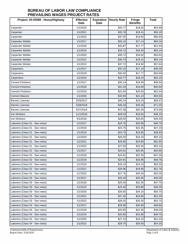
Project: 20-02589 - Heavy/Highway EffectiveDate
ExpirationDate
Hourly Rate FringeBenefits
Total
Carpenter 1/1/2020 $34.77 $18.92 $53.69
Carpenter 1/1/2021 $35.78 $19.41 $55.19
Carpenter 1/1/2022 $37.02 $19.92 $56.94
Carpenter Welder 1/1/2017 $33.10 $17.14 $50.24
Carpenter Welder 1/1/2018 $33.87 $17.77 $51.64
Carpenter Welder 1/1/2019 $34.72 $18.42 $53.14
Carpenter Welder 1/1/2020 $35.72 $18.92 $54.64
Carpenter Welder 1/1/2021 $36.73 $19.41 $56.14
Carpenter Welder 1/1/2022 $37.72 $19.92 $57.64
Carpenters 1/1/2017 $32.15 $17.14 $49.29
Carpenters 1/1/2018 $32.92 $17.77 $50.69
Carpenters 1/1/2019 $33.77 $18.42 $52.19
Cement Finishers 1/1/2017 $30.14 $19.40 $49.54
Cement Finishers 1/1/2018 $31.04 $19.90 $50.94
Cement Finishers 1/1/2019 $31.94 $20.50 $52.44
Cement Masons 1/1/2020 $32.84 $21.10 $53.94
Electric Lineman 5/29/2017 $45.24 $24.23 $69.47
Electric Lineman 5/28/2018 $46.29 $25.26 $71.55
Electric Lineman 5/27/2019 $47.38 $26.30 $73.68
Iron Workers 11/1/2016 $29.53 $18.62 $48.15
Iron Workers 5/1/2018 $28.56 $20.84 $49.40
Laborers (Class 01 - See notes) 1/1/2017 $24.75 $20.95 $45.70
Laborers (Class 01 - See notes) 1/1/2018 $24.75 $22.35 $47.10
Laborers (Class 01 - See notes) 1/1/2019 $24.75 $23.85 $48.60
Laborers (Class 01 - See notes) 1/1/2020 $26.00 $24.10 $50.10
Laborers (Class 01 - See notes) 1/1/2021 $26.80 $24.80 $51.60
Laborers (Class 01 - See notes) 1/1/2022 $27.60 $25.50 $53.10
Laborers (Class 02 - See notes) 1/1/2017 $24.91 $20.95 $45.86
Laborers (Class 02 - See notes) 1/1/2018 $24.91 $22.35 $47.26
Laborers (Class 02 - See notes) 1/1/2019 $24.91 $23.85 $48.76
Laborers (Class 02 - See notes) 1/1/2020 $26.16 $24.10 $50.26
Laborers (Class 02 - See notes) 1/1/2021 $26.96 $24.80 $51.76
Laborers (Class 02 - See notes) 1/1/2022 $27.76 $25.50 $53.26
Laborers (Class 03 - See notes) 1/1/2017 $25.40 $20.95 $46.35
Laborers (Class 03 - See notes) 1/1/2018 $25.40 $22.35 $47.75
Laborers (Class 03 - See notes) 1/1/2019 $25.40 $23.85 $49.25
Laborers (Class 03 - See notes) 1/1/2020 $26.65 $24.10 $50.75
Laborers (Class 03 - See notes) 1/1/2021 $27.45 $24.80 $52.25
Laborers (Class 03 - See notes) 1/1/2022 $28.25 $25.50 $53.75
Laborers (Class 04 - See notes) 1/1/2017 $25.85 $20.95 $46.80
Laborers (Class 04 - See notes) 1/1/2018 $25.85 $22.35 $48.20
Laborers (Class 04 - See notes) 1/1/2019 $25.85 $23.85 $49.70
Laborers (Class 04 - See notes) 1/1/2020 $27.10 $24.10 $51.20
Laborers (Class 04 - See notes) 1/1/2022 $28.70 $25.50 $54.20
BUREAU OF LABOR LAW COMPLIANCEPREVAILING WAGES PROJECT RATES
Commonwealth of Pennsylvania Department of Labor & IndustryReport Date: 3/26/2020 Page 5 of 8

Project: 20-02589 - Heavy/Highway EffectiveDate
ExpirationDate
Hourly Rate FringeBenefits
Total
Laborers (Class 05 - See notes) 1/1/2017 $26.26 $20.95 $47.21
Laborers (Class 05 - See notes) 1/1/2018 $26.26 $22.35 $48.61
Laborers (Class 05 - See notes) 1/1/2019 $26.26 $23.85 $50.11
Laborers (Class 05 - See notes) 1/1/2020 $27.51 $24.10 $51.61
Laborers (Class 05 - See notes) 1/1/2021 $28.31 $24.80 $53.11
Laborers (Class 05 - See notes) 1/1/2022 $29.11 $25.50 $54.61
Laborers (Class 06 - See notes) 1/1/2017 $23.10 $20.95 $44.05
Laborers (Class 06 - See notes) 1/1/2018 $23.10 $22.35 $45.45
Laborers (Class 06 - See notes) 1/1/2019 $23.10 $23.85 $46.95
Laborers (Class 06 - See notes) 1/1/2020 $24.35 $24.10 $48.45
Laborers (Class 06 - See notes) 1/1/2021 $25.15 $24.80 $49.95
Laborers (Class 06 - See notes) 1/1/2022 $25.95 $25.50 $51.45
Laborers (Class 07 - See notes) 1/1/2017 $25.75 $20.95 $46.70
Laborers (Class 07 - See notes) 1/1/2018 $25.75 $22.35 $48.10
Laborers (Class 07 - See notes) 1/1/2019 $25.75 $23.85 $49.60
Laborers (Class 07 - See notes) 1/1/2020 $27.00 $24.10 $51.10
Laborers (Class 07 - See notes) 1/1/2021 $27.80 $24.80 $52.60
Laborers (Class 07 - See notes) 1/1/2022 $28.60 $25.50 $54.10
Laborers (Class 08 - See notes) 1/1/2017 $27.25 $20.95 $48.20
Laborers (Class 08 - See notes) 1/1/2018 $27.25 $22.35 $49.60
Laborers (Class 08 - See notes) 1/1/2019 $27.25 $23.85 $51.10
Laborers (Class 08 - See notes) 1/1/2020 $28.50 $24.10 $52.60
Laborers (Class 08 - See notes) 1/1/2021 $29.30 $24.80 $54.10
Laborers (Class 08 - See notes) 1/1/2022 $30.10 $25.50 $55.60
Operators (Class 01 - see notes) 1/1/2017 $30.40 $19.98 $50.38
Operators (Class 01 - see notes) 1/1/2018 $31.00 $20.78 $51.78
Operators (Class 01 - see notes) 1/1/2019 $31.60 $21.68 $53.28
Operators (Class 01 - see notes) 1/1/2020 $32.60 $22.23 $54.83
Operators (Class 01 - see notes) 1/1/2021 $33.60 $22.73 $56.33
Operators (Class 01 - see notes) 1/1/2022 $34.50 $23.33 $57.83
Operators (Class 02 -see notes) 1/1/2017 $30.12 $19.98 $50.10
Operators (Class 02 -see notes) 1/1/2018 $30.72 $20.78 $51.50
Operators (Class 02 -see notes) 1/1/2019 $31.32 $21.68 $53.00
Operators (Class 02 -see notes) 1/1/2020 $32.32 $22.23 $54.55
Operators (Class 02 -see notes) 1/1/2021 $33.32 $22.73 $56.05
Operators (Class 02 -see notes) 1/1/2022 $34.22 $23.33 $57.55
Operators (Class 03 - See notes) 1/1/2017 $26.48 $19.98 $46.46
Operators (Class 03 - See notes) 1/1/2018 $27.08 $20.78 $47.86
Operators (Class 03 - See notes) 1/1/2019 $27.68 $21.68 $49.36
Operators (Class 03 - see notes) 1/1/2020 $28.68 $22.23 $50.91
Operators (Class 03 - see notes) 1/1/2021 $29.68 $22.73 $52.41
Operators (Class 03 - See notes) 1/1/2022 $30.58 $23.33 $53.91
Operators (Class 04 - See notes) 1/1/2017 $25.99 $19.98 $45.97
Operators (Class 04 - See notes) 1/1/2018 $26.59 $20.78 $47.37
BUREAU OF LABOR LAW COMPLIANCEPREVAILING WAGES PROJECT RATES
Commonwealth of Pennsylvania Department of Labor & IndustryReport Date: 3/26/2020 Page 6 of 8

Project: 20-02589 - Heavy/Highway EffectiveDate
ExpirationDate
Hourly Rate FringeBenefits
Total
Operators (Class 04 - See notes) 1/1/2019 $27.19 $21.68 $48.87
Operators (Class 04 - See notes) 1/1/2020 $28.19 $22.23 $50.42
Operators (Class 04 - See notes) 1/1/2021 $29.19 $22.73 $51.92
Operators (Class 04 - See notes) 1/1/2022 $30.09 $23.33 $53.42
Operators (Class 05 - See notes) 1/1/2017 $25.78 $19.98 $45.76
Operators (Class 05 - See notes) 1/1/2018 $26.38 $20.78 $47.16
Operators (Class 05 - See notes) 1/1/2019 $26.98 $21.68 $48.66
Operators (Class 05 - See notes) 1/1/2020 $27.98 $22.23 $50.21
Operators (Class 05 - See notes) 1/1/2021 $28.98 $22.73 $51.71
Operators (Class 05 - See notes) 1/1/2022 $29.88 $23.33 $53.21
Painters Class 1 (see notes) 6/1/2016 $31.58 $17.58 $49.16
Painters Class 1 (see notes) 6/1/2017 $31.85 $18.66 $50.51
Painters Class 1 (see notes) 6/1/2017 $31.98 $18.43 $50.41
Painters Class 1 (see notes) 6/1/2018 $32.50 $19.36 $51.86
Painters Class 1 (see notes) 6/1/2019 $33.15 $20.06 $53.21
Painters Class 2 (see notes) 6/1/2016 $31.58 $17.58 $49.16
Painters Class 2 (see notes) 6/1/2017 $34.08 $18.43 $52.51
Painters Class 2 (see notes) 6/1/2017 $33.95 $18.66 $52.61
Painters Class 2 (see notes) 6/1/2018 $34.60 $19.36 $53.96
Painters Class 2 (see notes) 6/1/2019 $35.25 $20.06 $55.31
Painters Class 3 (see notes) 6/1/2016 $33.68 $17.58 $51.26
Painters Class 3 (see notes) 6/1/2017 $33.95 $18.66 $52.61
Painters Class 3 (see notes) 6/1/2017 $27.58 $18.48 $46.06
Painters Class 3 (see notes) 6/1/2018 $34.60 $19.36 $53.96
Painters Class 3 (see notes) 6/1/2019 $35.25 $20.06 $55.31
Painters Class 4 (see notes) 6/1/2016 $26.95 $17.58 $44.53
Painters Class 4 (see notes) 6/1/2017 $27.27 $18.43 $45.70
Painters Class 4 (see notes) 6/1/2017 $27.16 $18.66 $45.82
Painters Class 4 (see notes) 6/1/2018 $27.68 $19.36 $47.04
Painters Class 4 (see notes) 6/1/2019 $28.20 $20.06 $48.26
Painters Class 5 (see notes) 6/1/2016 $21.90 $17.58 $39.48
Painters Class 5 (see notes) 6/1/2017 $22.07 $18.66 $40.73
Painters Class 5 (see notes) 6/1/2017 $22.16 $18.43 $40.59
Painters Class 5 (see notes) 6/1/2018 $22.49 $19.36 $41.85
Painters Class 5 (see notes) 6/1/2019 $22.91 $20.06 $42.97
Pile Driver Divers (Building, Heavy, Highway) 1/1/2017 $49.13 $17.95 $67.08
Pile Driver Divers (Building, Heavy, Highway) 1/1/2018 $50.33 $18.55 $68.88
Pile Driver Divers (Building, Heavy, Highway) 1/1/2019 $51.45 $19.30 $70.75
Pile Driver Divers (Building, Heavy, Highway) 1/1/2020 $53.10 $19.70 $72.80
Pile Driver Divers (Building, Heavy, Highway) 1/1/2021 $54.75 $20.10 $74.85
Pile Driver Divers (Building, Heavy, Highway) 1/1/2022 $56.40 $20.50 $76.90
Piledrivers 1/1/2017 $32.75 $17.95 $50.70
Piledrivers 1/1/2018 $33.55 $18.55 $52.10
Piledrivers 1/1/2019 $34.30 $19.30 $53.60
BUREAU OF LABOR LAW COMPLIANCEPREVAILING WAGES PROJECT RATES
Commonwealth of Pennsylvania Department of Labor & IndustryReport Date: 3/26/2020 Page 7 of 8

Project: 20-02589 - Heavy/Highway EffectiveDate
ExpirationDate
Hourly Rate FringeBenefits
Total
Piledrivers 1/1/2020 $35.40 $19.70 $55.10
Piledrivers 1/1/2021 $36.50 $20.10 $56.60
Piledrivers 1/1/2022 $37.60 $20.50 $58.10
Steamfitters (Heavy and Highway - Gas Distribution) 5/1/2017 $40.98 $32.53 $73.51
Truckdriver class 1(see notes) 1/1/2017 $27.93 $17.32 $45.25
Truckdriver class 1(see notes) 1/1/2018 $28.36 $18.29 $46.65
Truckdriver class 1(see notes) 1/1/2019 $28.83 $19.32 $48.15
Truckdriver class 1(see notes) 1/1/2020 $29.79 $20.13 $49.92
Truckdriver class 1(see notes) 1/1/2021 $30.54 $20.88 $51.42
Truckdriver class 1(see notes) 1/1/2022 $31.29 $21.63 $52.92
Truckdriver class 2 (see notes) 1/1/2017 $28.10 $17.42 $45.52
Truckdriver class 2 (see notes) 1/1/2018 $28.52 $18.40 $46.92
Truckdriver class 2 (see notes) 1/1/2019 $28.99 $19.43 $48.42
Truckdriver class 2 (see notes) 1/1/2020 $30.25 $20.43 $50.68
Truckdriver class 2 (see notes) 1/1/2021 $31.00 $21.18 $52.18
Truckdriver class 2 (see notes) 1/1/2022 $31.75 $21.93 $53.68
Truckdriver class 3 (see notes) 1/1/2017 $28.57 $17.71 $46.28
Truckdriver class 3 (see notes) 1/1/2018 $28.98 $18.70 $47.68
Truckdriver class 3 (see notes) 1/1/2019 $29.45 $19.73 $49.18
BUREAU OF LABOR LAW COMPLIANCEPREVAILING WAGES PROJECT RATES
Commonwealth of Pennsylvania Department of Labor & IndustryReport Date: 3/26/2020 Page 8 of 8

Department of General Services GSPUR-89 Rev. 11/06/12
Page 1 of 4
RECIPROCAL LIMITATIONS ACT REQUIREMENTS
Please Complete Applicable Portion of Pages 3 & 4 and Return with Bid.
NOTE: These Requirements Do Not Apply To Bids Under $10,000.00 I. REQUIREMENTS
A. The Reciprocal Limitations Act requires the Commonwealth to give preference to those bidders offering supplies produced, manufactured, mined or grown in Pennsylvania as against those bidders offering supplies produced, manufactured, mined or grown in any state that gives or requires a preference to supplies produced, manufactured, mined or grown in that state. The amount of the preference shall be equal to the amount of the preference applied by the other state for that particular supply.
The following is a list of states which have been found by the Department of General Services to have applied a preference for in-state supplies and the amount of the preference:
STATE PREFERENCE 1. Alaska 7% (applies only to timber, lumber, and manufactured lumber products originating in
the state) 2. Arizona 5% (construction materials produced or manufactured in the state only) 3. Hawaii 10% 4. Illinois 10% for coal only 5. Iowa 5% for coal only 6. Louisiana 4% meat and meat products 4% catfish 10% milk & dairy products 10% steel rolled in Louisiana 7% all other products 7. Montana 5% for residents * 3% for non-residents* *offering in-state goods, supplies, equipment and materials 8. New Mexico 5% 9. New York 3% for purchase of food only 10. Oklahoma 5% 11. Virginia 4% for coal only 12. Washington 5% (fuels mined or produced in the state only) 13. Wyoming 5%
B. The Reciprocal Limitations Act requires the Commonwealth to give preference to those bidders offering
printing performed in Pennsylvania as against those bidders offering printing performed in any state that gives or requires a preference to printing performed in that state. The amount of the preference shall be equal to the amount of the preference applied by the other state for that particular category of printing.
The following is a list of states which have been found by the Department of General Services to have applied a preference for in-state printing and the amount of the preference:
STATE PREFERENCE 1. Hawaii 15% 2. Idaho 10% 3. Louisiana 3% 4. Montana 8% 5. New Mexico 5% 6. Wyoming 10%
C. The Reciprocal Limitations Act, also requires the Commonwealth to give resident bidders a preference against
a nonresident bidder from any state that gives or requires a preference to bidders from that state or exclude bidders from states that exclude nonresident bidders. The amount of the preference shall be equal to the amount of the preference applied by the state of the nonresident bidder. The following is a list of the states which have been found by the Department of General Services to have applied a preference for in-state bidders and the amount of the preference:

Department of General Services GSPUR-89 Rev. 11/06/12
Page 2 of 4
STATE PREFERENCE 1. Alaska 5% (supplies only) 2. Arizona 5% (construction materials from Arizona resident dealers only) 3. California 5% (for supply contracts only in excess of $100,000.00) 4. Connecticut 10% (for supplies only) 5. Montana 3% 6. New Mexico 5% (for supplies only) 7. South Carolina 2% (under $2,500,000.00) 1% (over $2,500,000.00)
This preference does not apply to construction contracts nor where the price of a single unit exceeds $10,000.
8. West Virginia 2.5% (for the construction, repair or improvement of any buildings 9. Wyoming 5% STATE PROHIBITION 1. New Jersey For supply procurements or construction projects restricted to Department of General
Services Certified Small Businesses, New Jersey bidders shall be excluded from award even if they themselves are Department of General Services Certified Small Businesses.
D. The Reciprocal Limitations Act also requires the Commonwealth not to specify, use or purchase supplies
which are produced, manufactured, mined or grown in any state that prohibits the specification for, use, or purchase of such items in or on its public buildings or other works, when such items are not produced, manufactured, mined or grown in such state. The following is a list of the states which have been found by the Department of General Services to have prohibited the use of out-of-state supplies:
STATE PROHIBITION 1. Alabama Only for printing and binding involving ”messages of the Governor to the Legislature“, all
bills, documents and reports ordered by and for the use of the Legislature or either house thereof while in session; all blanks, circulars, notices and forms used in the office of or ordered by the Governor, or by any state official, board, commission, bureau or department, or by the clerks of the supreme court . . ./and other appellate courts/; and all blanks and forms ordered by and for the use of the Senate and Clerk or the House of Representatives, and binding the original records and opinions of the Supreme Court . . . /and other appellate courts/
2. Georgia Forest products only 3. Indiana Coal 4. Michigan Printing 5. New Mexico Construction 6. Ohio Only for House and Senate bills, general and local laws, and joint resolutions; the
journals and bulletins of the Senate and house of Representatives and reports, communications, and other documents which form part of the journals; reports, communications, and other documents ordered by the General Assembly, or either House, or by the executive department or elective state officers; blanks, circulars, and other work for the use of the executive departments, and elective state officers; and opinions of the Attorney General.
7. Rhode Island Only for food for state institutions.
*If the bid discloses that the bidder is offering to supply one of the above-listed products that is manufactured, mined, or grown in the listed state, it shall be rejected. Contractors are prohibited from supplying these items from these states.
II. CALCULATION OF PREFERENCE
In calculating the preference, the amount of a bid submitted by a Pennsylvania bidder shall be reduced by the percentage preference which would be given to a nonresident bidder by its state of residency (as found by the Department of General Services in Paragraph C above). Similarly, the amount of a bid offering Pennsylvania goods, supplies, equipment or materials shall be reduced by the percentage preference which would be given to another bidder by the state where the goods, supplies, equipment or materials are produced, manufactured, mined or grown (as found by the Department of General Services in Paragraphs A and B above).
Department of General Services GSPUR-89 Rev. 11/06/12
Page 3 of 4
THIS FORM MUST BE COMPLETED AND RETURNED WITH THE BID
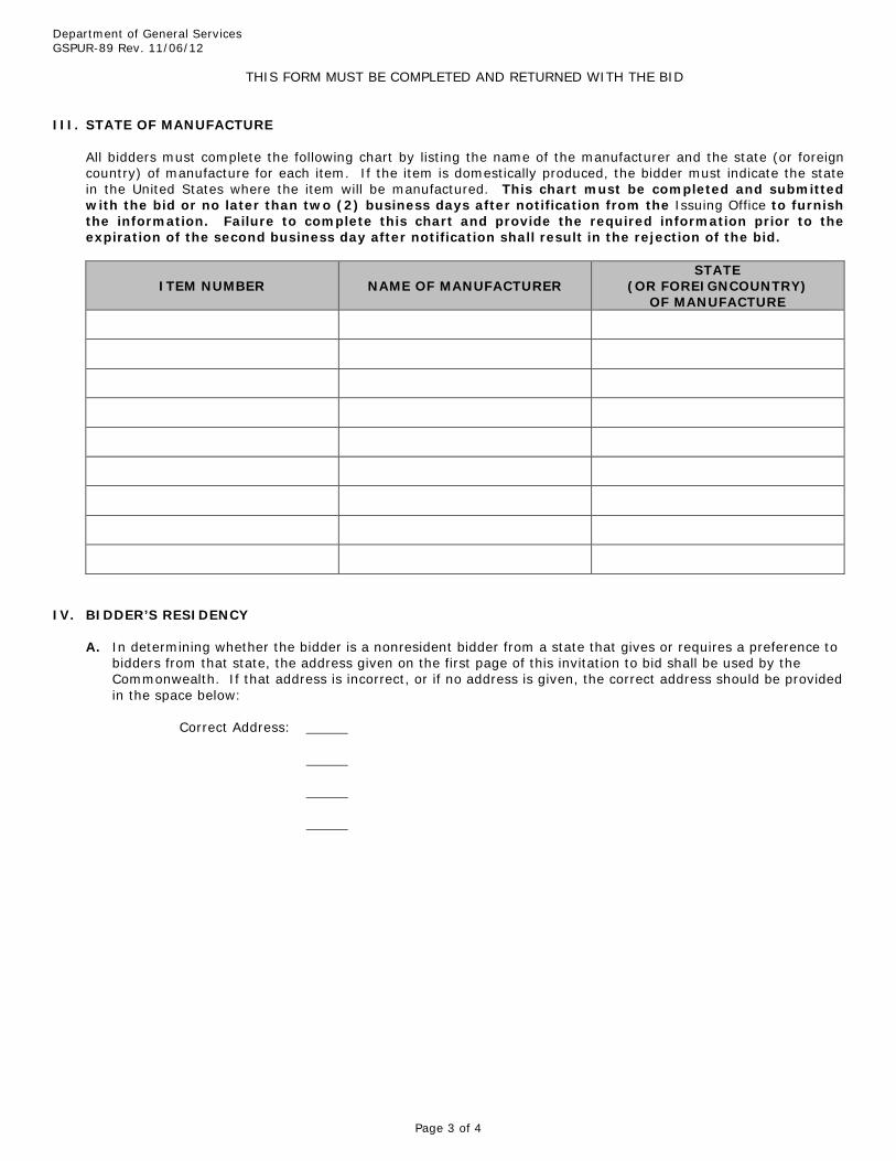
III. STATE OF MANUFACTURE
All bidders must complete the following chart by listing the name of the manufacturer and the state (or foreign country) of manufacture for each item. If the item is domestically produced, the bidder must indicate the state in the United States where the item will be manufactured. This chart must be completed and submitted with the bid or no later than two (2) business days after notification from the Issuing Office to furnish the information. Failure to complete this chart and provide the required information prior to the expiration of the second business day after notification shall result in the rejection of the bid.
ITEM NUMBER NAME OF MANUFACTURER STATE
(OR FOREIGNCOUNTRY) OF MANUFACTURE
IV. BIDDER’S RESIDENCY
A. In determining whether the bidder is a nonresident bidder from a state that gives or requires a preference to bidders from that state, the address given on the first page of this invitation to bid shall be used by the Commonwealth. If that address is incorrect, or if no address is given, the correct address should be provided in the space below:
Correct Address:

Department of General Services GSPUR-89 Rev. 11/06/12
Page 4 of 4
B. In order to claim the preference provided under Section I.B., Pennsylvania resident bidders must complete the following or have such information on file with the Issuing Office:
1. Address of bidder’s bona fide establishment in Pennsylvania at which it was transacting business on the
date when bids for this contract/requisition were first solicited: 2. a. If the bidder is a corporation:
(1) The corporation is or is not incorporated under the laws of the Commonwealth of
Pennsylvania.
(a) If the bidder is incorporated under the laws of the Commonwealth of Pennsylvania, provide date of incorporation:
(b) If the bidder is not incorporated under the laws of the Commonwealth of Pennsylvania,
it must have a certificate of authority to do business in the Commonwealth of Pennsylvania from the Pennsylvania Department of State as required by the Pennsylvania Business Corporation Law (15 P.S. §2001). Provide date of issuance of certificate of authority:
(2) The corporation is or is not conducting business in Pennsylvania under an assumed or
fictitious name. If the bidder is conducting business under an assumed or fictitious name, it must register the fictitious name with the Secretary of the Commonwealth and the office of the prothonotary of the county wherein the registered office of such corporation is located as required by the Fictitious Corporate Name Act, as amended 15 P.S. §51 et seq. Corporate bidders conducting business under an assumed or fictitious name must provide date of registry of the assumed or fictitious name:
b. If the bidder is a partnership:
(1) The partnership is or is not conducting business in Pennsylvania under an assumed or
fictitious name. If the bidder is conducting business under an assumed or fictitious name, it must file with the Secretary of the Commonwealth and the office of the prothonotary the county wherein the principal place of business is located as required by the Fictitious Name Act of May 24, 1945, P.L. 967, as amended 54 P.S. §28.1. Partnerships conducting business under an assumed or fictitious name must provide the date of filing of the assumed or fictitious name with the Secretary of the Commonwealth:
(2) The partnership is or is not a limited partnership formed under the laws of any
jurisdiction other than the Commonwealth of Pennsylvania. If the bidder is an Out-of-state limited partnership, it must register with the Pennsylvania Department of State as required by the Act of July 10, 1981, P.L. 237, as amended, 59 Pa. C.S.A. §503. Out-of-state limited partnerships must provide the date of registry with the Pennsylvania Department of State:
c. If the bidder is an individual:
He or she is or is not conducting business under an assumed or fictitious name. If the bidder is conducting business under an assumed or fictitious name, he or she must file with the Secretary of the Commonwealth and the office of the prothonotary in the county wherein the principal place of business is located as required by the Fictitious Name Act of May 24, 1945, P.L. 967, as amended, 54 P.S. §28.1. Individuals conducting business under an assumed or fictitious name must provide the date of filing of the assumed or fictitious name with the Secretary of the Commonwealth:
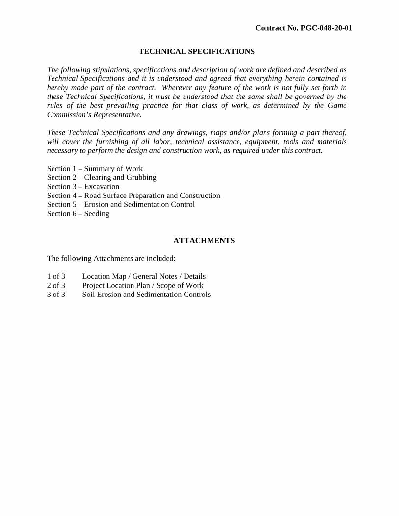
Contract No. PGC-048-20-01
TECHNICAL SPECIFICATIONS
The following stipulations, specifications and description of work are defined and described as Technical Specifications and it is understood and agreed that everything herein contained is hereby made part of the contract. Wherever any feature of the work is not fully set forth in these Technical Specifications, it must be understood that the same shall be governed by the rules of the best prevailing practice for that class of work, as determined by the Game Commission’s Representative.
These Technical Specifications and any drawings, maps and/or plans forming a part thereof, will cover the furnishing of all labor, technical assistance, equipment, tools and materials necessary to perform the design and construction work, as required under this contract.
Section 1 – Summary of Work Section 2 – Clearing and Grubbing Section 3 – Excavation Section 4 – Road Surface Preparation and Construction Section 5 – Erosion and Sedimentation Control Section 6 – Seeding
ATTACHMENTS
The following Attachments are included:
1 of 3 Location Map / General Notes / Details 2 of 3 Project Location Plan / Scope of Work 3 of 3 Soil Erosion and Sedimentation Controls

Contract No. PGC-048-20-01
TS-1-1
TECHNICAL SPECIFICATION SECTION 1 - SUMMARY OF WORK 1.1 – SCOPE OF PROJECT
The intent of this project is to construct improvements along Scrub Oak Road on State Game Lands #48 in Londonberry and Cumberland Valley Townships, Bedford County. The project generally consists of clearing and grubbing activities, grading, construction of stabilized roadway areas, and related work. 1.2 – WORK AREA SGL #48 is located in Cumberland valley and Londonberry Townships, Bedford County. The project site (Scrub Oak Road) is located along the ridge of Wills Mountain at the end of Wills Mountain Road which is the main vehicle access road to SGL #48 from the east. Wills Mountain Road begins at a gate near the game lands boundary at the foot of Wills Mountain and the junction with Paradise Road. The PGC owns property at the intersection of Paradise Road and US 220. Paradise Road intersects with US 220 approximately 9 miles south of Bedford and 1.5 miles north of the village of Patience. The project area (Segment 1) starts approximately 5.45 miles from the intersection of Paradise Road and US 220. The site is owned by the Pennsylvania Game Commission (PGC). 1.3 – WORK HOURS The work hours at the project site are during regular PGC business hours which are Monday through Friday, 7:45AM to 4:00PM. Work during different hours must have prior written approval by the PGC. Requests for different working hours must be submitted in writing three days in advance. 1.4 – ACCESS TO WORK AREA Access to the project sites and staging of equipment and materials shall be coordinated with the PGC. The Contractor shall keep access roads leading to the project sites open for use by the PGC. The Contractor is required to repair any ruts or other damage to the access roads and parking areas caused by construction equipment. 1.5 – CONTROL OF WORK AREA Coordinate with PGC staff for access and control of work areas (closure of parking areas). Provide barricades, signs and other devices as needed to prevent unauthorized access to work areas (parking areas) until construction activities are completed and parking areas are opened for public use. Do not block public roads at any time during construction. If necessary, provide temporary Maintenance and Control of Traffic in accordance with PennDOT Pub. 213 Temporary Traffic Control Guidelines and related PennDOT references.

Contract No. PGC-048-20-01
TS-1-2
1.6 – PERMITS, LAWS AND REGULATIONS The Contractor shall procure and pay for all permits, licenses, inspections, conveniences, or other approvals necessary for the execution of the contract. The PGC is not aware of any permits required for this project. The Contractor shall coordinate, acquire, pay for, and maintain for the duration of the project any and all permits or bonds required by local municipalities and/or PennDOT to utilize public roads for heavy hauling and related construction activities. Responsibilities shall include any pre or post construction inspections and related reports if required. Any and all costs related to permitting and bonding public roadways shall be included with and incidental to the Bid submitted by the Contractor and will not be paid for separately. The Contractor shall comply with all laws, ordinances, rules, orders and regulations relating to the performance of the work, the protection of adjacent property, the maintaining of surface passageways, guard fences, and/or other protective facilities. All applicable Federal and State laws and regulations, municipal ordinances and rules and regulations of all authorities, having jurisdiction over construction of the project shall apply to the contract throughout, and they shall be deemed to be included in the contract as a part, thereof, the same as though herein written out in full. All regulations of the Occupational Safety and Health Act are in effect on this contract. It will be the Contractor’s responsibility to make himself aware of all appropriate County, State and Federal regulations that apply to this contract. Any violations incurred from improper execution of the above provisions shall be paid for by the Contractor. Loss of time on the project from such violations will not be tolerated.

Contract No. PGC-048-20-01
TS-2-1
TECHNICAL SPECIFICATION SECTION 2 – CLEARING AND GRUBBING 2.1 -SCOPE This work includes incidental removal and disposal of trees, stumps, and vegetation in the project area necessary for the roadway improvements and related work. Clearing is cutting trees and brush so that stumps are no more than three inches above the ground. Grubbing is removal of stumps and roots at least twelve inches below finished grade. 2.2 - PROCEDURE
Review with PGC staff areas where clearing and grubbing will be necessary before commencing clearing and grubbing operations. Protect and do not damage any plants or trees, natural growth, or other objects outside the areas to be cleared and grubbed. Cut down the trees and brush in the designated areas. Cut the trees and brush so that the stumps are no more than three inches above the ground. Stumps must also be removed from the areas designated to be grubbed. Cleared and grubbed material shall be placed at the project site as directed by PGC staff. Burning is not permitted at the site.
2.3 - MEASUREMENT AND PAYMENT
None – No separate payment will be made for this item. This work shall be considered incidental to the other items of work in the project and included in the Bid and will not be measured and paid for separately.

Contract No. PGC-048-20-01
TS-3-1
TECHNICAL SPECIFICATION SECTION NO. 3 - EXCAVATION
3.1- SCOPE This work includes grading and leveling truck turn-around areas and preparation of roadway subgrade for placement of 2RC coarse aggregate roadway base/surface and removal, hauling, and disposal of all materials encountered for construction of the project as required and directed by PGC staff.
3.2 - PROCEDURE A. General - Follow all guidelines set forth in the Construction Industry Standards, OSHA 2207, of the Occupational Safety and Health Administration, U.S. Department of Labor. Protect the work, adjacent roadways, and property. The Contractor shall contact the PA One Call System at 1-800-242-1776 prior to excavation operations at the site. The Contractor shall coordinate work and roadway alignment / corridor areas layout Segment start and end locations with PGC staff. Do not over-excavate - unauthorized excavation and replacement of materials in the over-excavated areas will not be measured and paid for. Replace over-excavated work with concrete, gravel, earth or other materials designated by, and at no additional cost to the Game Commission. B. Excavation - Remove all materials to the limits required for the roadway improvements. C. Disposal – Suitable excavated materials can be used for backfilling and grading at the site. Unsuitable materials and excess excavated material shall be disposed of on-site as directed by PGC staff. 3.3 - MEASUREMENT AND PAYMENT
None – No separate payment will be made for this item. This work shall be considered incidental to the other items of work in the project and included in the Bid and will not be measured and paid for separately.

Contract No. PGC-048-20-01
TS-4-1
TECHNICAL SPECIFICATION SECTION NO. 4 – ROAD SURFACE PREPARATION AND CONSTRUCTION 4.1- SCOPE This work includes but is not limited to preparing the road subgrade by clearing the corridor of trees and vegetation, filling stump holes, removing organic material, scarifying, grading and shaping the scarified material and compacting the graded material; constructing the new road surface with 2RC coarse aggregate as specified herein and shown on the Drawings. 4.2– MATERIALS A. 2RC Select Granular Material – 2RC shall conform to the requirements of Section 703.3 of PennDOT Pub. 408. B. AASHTO #1 Coarse Aggregate - The stone shall Type A quality conforming to the requirements of Section 703.2 of PennDOT Pub. 408. Obtain the AASHTO #1 stone from a source approved in PennDOT Bulletin 14. 4.3 – APPROVAL OF MATERIALS Submit gradation tests, certifications and other documents to attest to the suitability of the aggregates to the PGC for review and approval. Representatives from the PGC will review the submittals and visit the quarry to review and approve the material. Do not order materials until final approval is received from the PGC. 4.4 - PROCEDURE A. General – All work in this section shall be coordinated to provide the designed features of the new road surface. The design features are listed by roadway segment on Drawing Sheet No. 2 Scope of Work. Roadway segments and other features are identified in the field using marked survey stakes and paint. It is recommended that construction of the road improvements progress in a northern to southern direction beginning at Segment No. 1. B. Project Layout – The project layout was prepared by Pennsylvania Game Commission (PGC) Southcentral Region Staff. A PGC representative will perform periodic site inspections during the construction phase of this project to provide assistance and quality control C. Filling Potholes – Potholes from stump removal must be filled. Fill the stump holes with on-site material. Compact the material with a vibratory plate compactor and/or jumping jack. D. Remove Organic Material – Scrape leaves, roots, grass, weeds, etc. off the surface of the road alignment. Spoil this material in piles at the site. The PGC will designate area(s) for spoiling this material.
Contract No. PGC-048-20-01
TS-4-2
E. Scarifying – Scarify the surface of the existing road to a depth of two (2) inches to obtain material for grading and shaping the road. F. Fracture Exposed Bedrock – Break up exposed bedrock to a depth of four (4) inches below the proposed subgrade surface to allow the 2RC Select Granular Material to knit and bind with the subgrade. G. Grading and Shaping – Grade and shape the scarified material and fractured bedrock to form the road shapes (center crown, out-slope, in-slope) and to provide an even surface for placement of the 2RC Select Granular Material. H. Compaction – Compact the graded and shaped material with a single drum (smooth) vibratory roller (min. 10 ton). One pass of the roller is required. I. 2RC Select Granular Material Road Section – Place an 8-inch+ layer of 2RC Select Granular Material on the prepared subgrade. Compact the 2RC Select Granular Material with a single drum smooth roller (vibratory, 10-ton min.) to a minimum compacted thickness of 5-inches. Maintain the road shape, slope and profile during placement and compaction operations. 4.5 - MEASUREMENT AND PAYMENT Lump Sum (LS) for Each Segment – Roadway improvements shall be paid for based on a Lump Sum (LS) unit price for each segment completed as listed on the Bid Schedule / Form of Proposal. The Lump Sum unit price for each segment shall include all labor, equipment, materials, services, and incidental items to complete work required for that segment including but not limited to erosion and sedimentation controls, clearing and grubbing operations, removing organic material, excavations, filling stump holes, scarifying / grading / shaping the subgrade, breaking up exposed bedrock, coarse aggregate, select granular material, subgrade and roadway surface compaction, abandonment of retired road segments, evenly spread waste material / vegetation / trees / stumps on abandoned road segments, temporary restoration, seed and mulch and final restoration. Lump Sum unit prices for each segment shall include all costs for the work and items specified herein and outlined on the General and Detailed Scope of Work on Drawing No. 2. The Contractor shall provide copies of ALL select granular material and coarse aggregate load slips provided by the aggregate supplier / hauler for verification of quantities and quality control. Load slips shall include the following minimum information: 1) supplier, 2) contractor, 3) project name, 4) aggregate type, 5) quantity delivered (tons), 6) delivery date, and 7) specific delivery location. Material Estimates (For Information and Post-Construction Verification / Quality Control - Contractor responsible for estimating and providing quantities required to provide improved roadway specified and shown on drawings): 2RC Select Granular Material – 4,300 Cubic yards / 6,900 Tons AASHTO No. 1 – 4.75 Cubic Yards / 7 Tons

Contract No. PGC-048-20-01
TS-5-1
TECHNICAL SPECIFICATION SECTION 6 - EROSION AND SEDIMENTATION CONTROL 5.1 -SCOPE This work consists of implementing the soil erosion and sedimentation (E&S) control measures contained on the drawings and described herein. E&S control measures shall be implemented in accordance with the provisions of the Clean Streams Law and 25 Pennsylvania Code Chapter 102. The Pennsylvania Department of Environmental Protection Erosion and Sediment Program Pollution Control Manual as well as the Commonwealth of Pennsylvania Department of Transportation Publication 408 are the sources for the construction items described and referenced herein and incorporated into this plan. 5.2 – PROCEDURE A. Project Description – The project site is located along the ridge top of Wills Mountain on
SGL #48 in Londonberry and Cumberland Valley Townships, Bedford County. The proposed project consists of roadway improvements on Scrub Oak Road, a PGC access / administrative road on SGL #48, to facilitate future wildlife habitat improvement and forestry management activities.
The estimated total area affected by the project along the approximate 2.68-mile road corridor is 12.34 acres. This Soil Erosion and Sedimentation Control Plan is designed to control soil erosion at its source and to prevent runoff flows from carrying sediment beyond the work area limits. The Contractor is responsible for the implementation and execution of this plan and for providing and maintaining proper soil erosion and sedimentation controls during the duration of the project until permanent stabilization conditions are achieved.
B. Stormwater Runoff and Drainage – The project sites consist of an existing access / administrative road corridor on an undeveloped, rural, forested PGC State Game Land. Post construction runoff will reach existing drainage features and surface waters by way of overland flow consistent with existing conditions. Existing storm water flow at the individual sites will not be substantially altered as a result of the project. Existing drainage features or facilities disturbed during construction shall be repaired or reconstructed by the Contractor.
Construction details are included with or referenced in the Contract Documents. Proposed
roadway and truck turn-around areas will be graded as needed to suit existing site conditions and to accommodate access; however, finished contours for the affected areas will not be substantially different than existing. Roadway surfaces will be stabilized with aggregate. All other disturbed areas will be restored to their pre-construction conditions with seed and mulch.

Contract No. PGC-048-20-01
TS-5-2
Drainage from the site flows to tributaries to Growden Run and Evitts Creek on the east and Little Wills Run on the west (Chapter 93 designations: HQ-CWF and CWF).
C. Soils Information / Limitations - Soils information for the project is available from the
U.S.D.A. Natural Resources Conservation Service soil survey information for Bedford County, Pennsylvania. For reference and information, a Soils Report for the project site is included as an Attachment to this specification section.
The Contractor shall provide appropriate excavation equipment and techniques to conduct
earthwork operations required for the project. Separate unsuitable materials prior to compacting embankment fill.
Subsurface conditions from the NRCS Soil Survey have not been verified in the field by the PGC.
D. Hydrology and Hydraulics - Construction will not significantly affect the overall
hydrology of the project sites. Vegetation clearing and grubbing and grading work will be required for the roadway and turn-around construction. Roadways will be stabilized with aggregate and all other disturbed areas and pre-construction drainage patterns will be restored after the construction activities have ended.
The Contractor shall provide and maintain E&S controls during construction as described herein and shown on the details to minimize the impact of runoff during rainfall events. Once the temporary impacts of construction have ended, the pre-existing hydrology will be re-established.
E. Erosion Control Measures -
1. General
a.) Accelerated erosion control shall be accomplished through the rapid stabilization of all disturbed surfaces throughout the project area, use of Best Management Practices (BMPs), and precautions in the use of construction equipment.
b.) During the earth disturbance activity, precautions must be taken to prevent
accelerated erosion, minimize damage, injury or destruction of property; prevent pollution; protect natural vegetation not targeted for removal during the activity/project; and protect natural drainage ways and surface waters. All disturbed areas shall be stabilized immediately.
c.) The Contractor shall provide temporary erosion control measures as required
and site conditions dictate to reduce the erosion potential of the site.
2. Temporary Stabilization

Contract No. PGC-048-20-01
TS-5-3
a.) Provide temporary stabilization of disturbed areas as shown on the details.
b.) At a minimum, all disturbed areas shall be temporarily restored and stabilized (mulched) within 4 days of the disturbance. Seed mixture and application rates are included in the specifications.
C. Permanent Stabilization
a.) Permanent seeding and soil supplements shall be provided on disturbed and
final graded areas during the germinating season as soon as practical but not than 15 days after disturbance. Generally, seeding and mulching shall be as specified herein and on the drawings.
b.) Provide permanent stabilization of disturbed areas as shown on the details and
specified herein.
c.) The project area will be considered permanently stabilized when all permanent control measures/facilities have been completed and are operational, all temporary control measures/facilities removed, and a minimum uniform 70% perennial vegetative cover, with a density capable of resisting accelerated erosion and sedimentation is established.
D. Maintenance
a.) Maintain temporary control measures and facilities as shown on the details.
b.) Sediment accumulation shall be removed and disposed of at approved locations.
These locations shall be selected such that the sediment will not erode into the construction area or any natural waterway.
c.) Stabilized coarse aggregate (stone or gravel) surfaces that become eroded shall
be restored with additional coarse aggregate materials.
d.) Any permanent seeded areas that become eroded shall be repaired / regraded, seeded, and new mulch applied.
e.) If the vegetative cover deteriorates and becomes ineffective, a fertilization and
re-seeding program shall be established and carried out as the construction proceeds. Areas where failures have been experienced in the establishment of both permanent and temporary vegetative protection shall be promptly treated. Re-establishment of permanent vegetative cover shall be initiated as soon as possible.
f.) After permanent site stabilization has been achieved, temporary erosion and
sedimentation controls must be removed. Areas disturbed during removal of the

Contract No. PGC-048-20-01
TS-5-4
control must be stabilized immediately. Re-grade areas as needed and seed and mulch using the permanent seeding schedule as indicated.
F. Recycling and Disposal of Construction Materials - All construction materials, including
soils and aggregates, should be recycled and/or re-used to the greatest extent possible at the Project Site. Woody vegetation waste materials should be shredded/chipped for use on-site as mulch materials if possible or as directed by PGC staff. Other debris and other construction by-products, including waste pipe / fitting materials, metal, paper, plastic, cardboard, batteries, rubber, etc. shall be properly disposed of at a local recycling center or waste transfer/landfill site. The Contractor shall not disposal of waste materials on-site via burning or burial.
G. Waste Disposal Sites - Excess excavated material shall be properly and legally disposed of off-site or as directed by the PGC. The contractor shall provide appropriate soil erosion and sedimentation controls for the waste sites and they shall be stabilized. Provision of E&S controls at disposal sites is considered incidental to construction.
H. Failure to implement soil erosion and sediment pollution control measures may result in a
cease and desist order, causing shutdown of the work. No extension of time, nor additional compensation will be granted if such a shutdown should occur as a result of act or neglect of the Contractor.
5.3 - MEASUREMENT AND PAYMENT
None – No separate payment will be made for this item. This work shall be considered incidental to the other items of work in the project and included in the Bid and will not be measured and paid for separately.
United StatesDepartment ofAgriculture
A product of the NationalCooperative Soil Survey,a joint effort of the UnitedStates Department ofAgriculture and otherFederal agencies, Stateagencies including theAgricultural ExperimentStations, and localparticipants
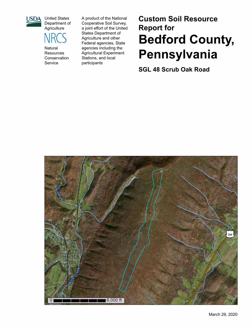
Custom Soil Resource Report for
Bedford County, PennsylvaniaSGL 48 Scrub Oak Road
NaturalResourcesConservationService
March 29, 2020

PrefaceSoil surveys contain information that affects land use planning in survey areas. They highlight soil limitations that affect various land uses and provide information about the properties of the soils in the survey areas. Soil surveys are designed for many different users, including farmers, ranchers, foresters, agronomists, urban planners, community officials, engineers, developers, builders, and home buyers. Also, conservationists, teachers, students, and specialists in recreation, waste disposal, and pollution control can use the surveys to help them understand, protect, or enhance the environment.
Various land use regulations of Federal, State, and local governments may impose special restrictions on land use or land treatment. Soil surveys identify soil properties that are used in making various land use or land treatment decisions. The information is intended to help the land users identify and reduce the effects of soil limitations on various land uses. The landowner or user is responsible for identifying and complying with existing laws and regulations.
Although soil survey information can be used for general farm, local, and wider area planning, onsite investigation is needed to supplement this information in some cases. Examples include soil quality assessments (http://www.nrcs.usda.gov/wps/portal/nrcs/main/soils/health/) and certain conservation and engineering applications. For more detailed information, contact your local USDA Service Center (https://offices.sc.egov.usda.gov/locator/app?agency=nrcs) or your NRCS State Soil Scientist (http://www.nrcs.usda.gov/wps/portal/nrcs/detail/soils/contactus/?cid=nrcs142p2_053951).
Great differences in soil properties can occur within short distances. Some soils are seasonally wet or subject to flooding. Some are too unstable to be used as a foundation for buildings or roads. Clayey or wet soils are poorly suited to use as septic tank absorption fields. A high water table makes a soil poorly suited to basements or underground installations.
The National Cooperative Soil Survey is a joint effort of the United States Department of Agriculture and other Federal agencies, State agencies including the Agricultural Experiment Stations, and local agencies. The Natural Resources Conservation Service (NRCS) has leadership for the Federal part of the National Cooperative Soil Survey.
Information about soils is updated periodically. Updated information is available through the NRCS Web Soil Survey, the site for official soil survey information.
The U.S. Department of Agriculture (USDA) prohibits discrimination in all its programs and activities on the basis of race, color, national origin, age, disability, and where applicable, sex, marital status, familial status, parental status, religion, sexual orientation, genetic information, political beliefs, reprisal, or because all or a part of an individual's income is derived from any public assistance program. (Not all prohibited bases apply to all programs.) Persons with disabilities who require
2

alternative means for communication of program information (Braille, large print, audiotape, etc.) should contact USDA's TARGET Center at (202) 720-2600 (voice and TDD). To file a complaint of discrimination, write to USDA, Director, Office of Civil Rights, 1400 Independence Avenue, S.W., Washington, D.C. 20250-9410 or call (800) 795-3272 (voice) or (202) 720-6382 (TDD). USDA is an equal opportunity provider and employer.
3
ContentsPreface.................................................................................................................... 2Soil Map.................................................................................................................. 5
Soil Map................................................................................................................6Legend..................................................................................................................7Map Unit Legend.................................................................................................. 8Map Unit Descriptions.......................................................................................... 8
Bedford County, Pennsylvania........................................................................10DkC—Dystrocrepts-Rock outcrop complex, 3 to 15 percent slopes........... 10HTC—Hazleton-Clymer association, 8 to 25 percent slopes, extremely
stony......................................................................................................11Soil Information for All Uses...............................................................................14
Suitabilities and Limitations for Use....................................................................14Building Site Development..............................................................................14
Unpaved Local Roads and Streets (SGL 48 Scrub Oak Road).................. 14Soil Reports........................................................................................................ 19
Building Site Development..............................................................................19Roads and Streets, Shallow Excavations, and Lawns and
Landscaping (SGL 48 Scrub Oak Road).............................................. 19Land Management.......................................................................................... 21
Hazard of Erosion and Suitability for Roads on Forestland (SGL 48 Scrub Oak Road).................................................................................. 22
Soil Physical Properties.................................................................................. 24Engineering Properties (SGL 48 Scrub Oak Road).....................................24Physical Soil Properties (SGL 48 Scrub Oak Road)................................... 29
4
Soil MapThe soil map section includes the soil map for the defined area of interest, a list of soil map units on the map and extent of each map unit, and cartographic symbols displayed on the map. Also presented are various metadata about data used to produce the map, and a description of each soil map unit.
5

6
Custom Soil Resource ReportSoil Map
4408
700
4409
300
4409
900
4410
500
4411
100
4411
700
4412
300
4412
900
4413
500
4408
700
4409
300
4409
900
4410
500
4411
100
4411
700
4412
300
4412
900
4413
500
695900 696500 697100 697700 698300 698900 699500
695900 696500 697100 697700 698300 698900 699500
39° 51' 0'' N78
° 4
2' 4
4'' W
39° 51' 0'' N
78° 4
0' 0
'' W
39° 48' 12'' N
78° 4
2' 4
4'' W
39° 48' 12'' N
78° 4
0' 0
'' W
N
Map projection: Web Mercator Corner coordinates: WGS84 Edge tics: UTM Zone 17N WGS840 1000 2000 4000 6000
Feet0 350 700 1400 2100
MetersMap Scale: 1:25,200 if printed on A portrait (8.5" x 11") sheet.

MAP LEGEND MAP INFORMATION
Area of Interest (AOI)Area of Interest (AOI)
SoilsSoil Map Unit Polygons
Soil Map Unit Lines
Soil Map Unit Points
Special Point FeaturesBlowout
Borrow Pit
Clay Spot
Closed Depression
Gravel Pit
Gravelly Spot
Landfill
Lava Flow
Marsh or swamp
Mine or Quarry
Miscellaneous Water
Perennial Water
Rock Outcrop
Saline Spot
Sandy Spot
Severely Eroded Spot
Sinkhole
Slide or Slip
Sodic Spot
Spoil Area
Stony Spot
Very Stony Spot
Wet Spot
Other
Special Line Features
Water FeaturesStreams and Canals
TransportationRails
Interstate Highways
US Routes
Major Roads
Local Roads
BackgroundAerial Photography
The soil surveys that comprise your AOI were mapped at 1:24,000.
Please rely on the bar scale on each map sheet for map measurements.
Source of Map: Natural Resources Conservation ServiceWeb Soil Survey URL: Coordinate System: Web Mercator (EPSG:3857)
Maps from the Web Soil Survey are based on the Web Mercator projection, which preserves direction and shape but distorts distance and area. A projection that preserves area, such as the Albers equal-area conic projection, should be used if more accurate calculations of distance or area are required.
This product is generated from the USDA-NRCS certified data as of the version date(s) listed below.
Soil Survey Area: Bedford County, PennsylvaniaSurvey Area Data: Version 14, Sep 16, 2019
Soil map units are labeled (as space allows) for map scales 1:50,000 or larger.
Date(s) aerial images were photographed: Oct 9, 2011—Nov 6, 2011
The orthophoto or other base map on which the soil lines were compiled and digitized probably differs from the background imagery displayed on these maps. As a result, some minor shifting of map unit boundaries may be evident.
Custom Soil Resource Report
7

Map Unit Legend
Map Unit Symbol Map Unit Name Acres in AOI Percent of AOI
DkC Dystrocrepts-Rock outcrop complex, 3 to 15 percent slopes
174.4 58.9%
HTC Hazleton-Clymer association, 8 to 25 percent slopes, extremely stony
121.7 41.1%
Totals for Area of Interest 296.1 100.0%
Map Unit DescriptionsThe map units delineated on the detailed soil maps in a soil survey represent the soils or miscellaneous areas in the survey area. The map unit descriptions, along with the maps, can be used to determine the composition and properties of a unit.
A map unit delineation on a soil map represents an area dominated by one or more major kinds of soil or miscellaneous areas. A map unit is identified and named according to the taxonomic classification of the dominant soils. Within a taxonomic class there are precisely defined limits for the properties of the soils. On the landscape, however, the soils are natural phenomena, and they have the characteristic variability of all natural phenomena. Thus, the range of some observed properties may extend beyond the limits defined for a taxonomic class. Areas of soils of a single taxonomic class rarely, if ever, can be mapped without including areas of other taxonomic classes. Consequently, every map unit is made up of the soils or miscellaneous areas for which it is named and some minor components that belong to taxonomic classes other than those of the major soils.
Most minor soils have properties similar to those of the dominant soil or soils in the map unit, and thus they do not affect use and management. These are called noncontrasting, or similar, components. They may or may not be mentioned in a particular map unit description. Other minor components, however, have properties and behavioral characteristics divergent enough to affect use or to require different management. These are called contrasting, or dissimilar, components. They generally are in small areas and could not be mapped separately because of the scale used. Some small areas of strongly contrasting soils or miscellaneous areas are identified by a special symbol on the maps. If included in the database for a given area, the contrasting minor components are identified in the map unit descriptions along with some characteristics of each. A few areas of minor components may not have been observed, and consequently they are not mentioned in the descriptions, especially where the pattern was so complex that it was impractical to make enough observations to identify all the soils and miscellaneous areas on the landscape.
The presence of minor components in a map unit in no way diminishes the usefulness or accuracy of the data. The objective of mapping is not to delineate pure taxonomic classes but rather to separate the landscape into landforms or landform segments that have similar use and management requirements. The
Custom Soil Resource Report
8

delineation of such segments on the map provides sufficient information for the development of resource plans. If intensive use of small areas is planned, however, onsite investigation is needed to define and locate the soils and miscellaneous areas.
An identifying symbol precedes the map unit name in the map unit descriptions. Each description includes general facts about the unit and gives important soil properties and qualities.
Soils that have profiles that are almost alike make up a soil series. Except for differences in texture of the surface layer, all the soils of a series have major horizons that are similar in composition, thickness, and arrangement.
Soils of one series can differ in texture of the surface layer, slope, stoniness, salinity, degree of erosion, and other characteristics that affect their use. On the basis of such differences, a soil series is divided into soil phases. Most of the areas shown on the detailed soil maps are phases of soil series. The name of a soil phase commonly indicates a feature that affects use or management. For example, Alpha silt loam, 0 to 2 percent slopes, is a phase of the Alpha series.
Some map units are made up of two or more major soils or miscellaneous areas. These map units are complexes, associations, or undifferentiated groups.
A complex consists of two or more soils or miscellaneous areas in such an intricate pattern or in such small areas that they cannot be shown separately on the maps. The pattern and proportion of the soils or miscellaneous areas are somewhat similar in all areas. Alpha-Beta complex, 0 to 6 percent slopes, is an example.
An association is made up of two or more geographically associated soils or miscellaneous areas that are shown as one unit on the maps. Because of present or anticipated uses of the map units in the survey area, it was not considered practical or necessary to map the soils or miscellaneous areas separately. The pattern and relative proportion of the soils or miscellaneous areas are somewhat similar. Alpha-Beta association, 0 to 2 percent slopes, is an example.
An undifferentiated group is made up of two or more soils or miscellaneous areas that could be mapped individually but are mapped as one unit because similar interpretations can be made for use and management. The pattern and proportion of the soils or miscellaneous areas in a mapped area are not uniform. An area can be made up of only one of the major soils or miscellaneous areas, or it can be made up of all of them. Alpha and Beta soils, 0 to 2 percent slopes, is an example.
Some surveys include miscellaneous areas. Such areas have little or no soil material and support little or no vegetation. Rock outcrop is an example.
Custom Soil Resource Report
9

Bedford County, Pennsylvania
DkC—Dystrocrepts-Rock outcrop complex, 3 to 15 percent slopes
Map Unit SettingNational map unit symbol: l5s0Elevation: 400 to 3,800 feetMean annual precipitation: 34 to 60 inchesMean annual air temperature: 46 to 57 degrees FFrost-free period: 110 to 180 daysFarmland classification: Not prime farmland
Map Unit CompositionDystrochrepts and similar soils: 65 percentMinor components: 30 percentEstimates are based on observations, descriptions, and transects of the mapunit.
Description of Dystrochrepts
SettingLandform: RidgesLandform position (two-dimensional): ShoulderLandform position (three-dimensional): Upper third of mountainflankDown-slope shape: Linear, convexAcross-slope shape: Convex, linearParent material: Residuum weathered from quartzite and/or residuum weathered
from orthoquartzite
Typical profileH1 - 0 to 6 inches: extremely stony sandy loamH2 - 6 to 40 inches: very channery sandy loamH3 - 40 to 60 inches: extremely channery loamH4 - 60 to 64 inches: bedrock
Properties and qualitiesSlope: 8 to 15 percentPercent of area covered with surface fragments: 9.0 percentDepth to restrictive feature: 10 to 80 inches to lithic bedrockNatural drainage class: Well drainedRunoff class: Very lowCapacity of the most limiting layer to transmit water (Ksat): High to very high (6.00
to 20.00 in/hr)Depth to water table: More than 80 inchesFrequency of flooding: NoneFrequency of ponding: NoneAvailable water storage in profile: Low (about 5.6 inches)
Interpretive groupsLand capability classification (irrigated): None specifiedLand capability classification (nonirrigated): 7sHydrologic Soil Group: AHydric soil rating: No
Custom Soil Resource Report
10

Minor Components
Rock outcropPercent of map unit: 15 percentHydric soil rating: No
HazletonPercent of map unit: 5 percentHydric soil rating: No
BuchananPercent of map unit: 5 percentHydric soil rating: No
LaidigPercent of map unit: 5 percentHydric soil rating: No
HTC—Hazleton-Clymer association, 8 to 25 percent slopes, extremely stony
Map Unit SettingNational map unit symbol: l5sdElevation: 350 to 2,900 feetMean annual precipitation: 34 to 60 inchesMean annual air temperature: 46 to 59 degrees FFrost-free period: 110 to 190 daysFarmland classification: Not prime farmland
Map Unit CompositionHazleton and similar soils: 45 percentClymer and similar soils: 40 percentMinor components: 15 percentEstimates are based on observations, descriptions, and transects of the mapunit.
Description of Hazleton
SettingLandform: MountainsLandform position (two-dimensional): SummitLandform position (three-dimensional): MountainflankDown-slope shape: ConvexAcross-slope shape: ConvexParent material: Residuum weathered from sandstone
Typical profileH1 - 0 to 2 inches: channery sandy loamH2 - 2 to 58 inches: extremely channery loamH3 - 58 to 64 inches: bedrock
Custom Soil Resource Report
11
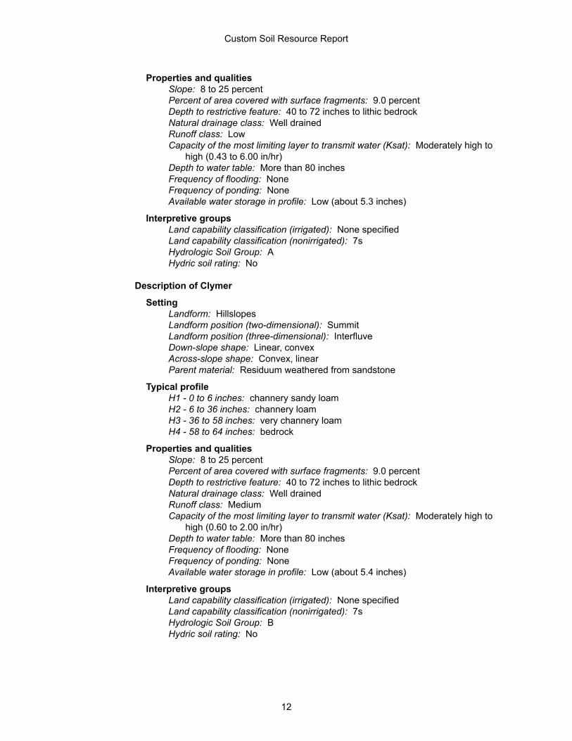
Properties and qualitiesSlope: 8 to 25 percentPercent of area covered with surface fragments: 9.0 percentDepth to restrictive feature: 40 to 72 inches to lithic bedrockNatural drainage class: Well drainedRunoff class: LowCapacity of the most limiting layer to transmit water (Ksat): Moderately high to
high (0.43 to 6.00 in/hr)Depth to water table: More than 80 inchesFrequency of flooding: NoneFrequency of ponding: NoneAvailable water storage in profile: Low (about 5.3 inches)
Interpretive groupsLand capability classification (irrigated): None specifiedLand capability classification (nonirrigated): 7sHydrologic Soil Group: AHydric soil rating: No
Description of Clymer
SettingLandform: HillslopesLandform position (two-dimensional): SummitLandform position (three-dimensional): InterfluveDown-slope shape: Linear, convexAcross-slope shape: Convex, linearParent material: Residuum weathered from sandstone
Typical profileH1 - 0 to 6 inches: channery sandy loamH2 - 6 to 36 inches: channery loamH3 - 36 to 58 inches: very channery loamH4 - 58 to 64 inches: bedrock
Properties and qualitiesSlope: 8 to 25 percentPercent of area covered with surface fragments: 9.0 percentDepth to restrictive feature: 40 to 72 inches to lithic bedrockNatural drainage class: Well drainedRunoff class: MediumCapacity of the most limiting layer to transmit water (Ksat): Moderately high to
high (0.60 to 2.00 in/hr)Depth to water table: More than 80 inchesFrequency of flooding: NoneFrequency of ponding: NoneAvailable water storage in profile: Low (about 5.4 inches)
Interpretive groupsLand capability classification (irrigated): None specifiedLand capability classification (nonirrigated): 7sHydrologic Soil Group: BHydric soil rating: No
Custom Soil Resource Report
12

Minor Components
MeckesvillePercent of map unit: 5 percentLandform: Mountain valleysLandform position (two-dimensional): FootslopeLandform position (three-dimensional): Lower third of mountainflankDown-slope shape: ConcaveAcross-slope shape: LinearHydric soil rating: No
UngersPercent of map unit: 5 percentHydric soil rating: No
BuchananPercent of map unit: 5 percentHydric soil rating: No
Custom Soil Resource Report
13

Soil Information for All Uses
Suitabilities and Limitations for UseThe Suitabilities and Limitations for Use section includes various soil interpretations displayed as thematic maps with a summary table for the soil map units in the selected area of interest. A single value or rating for each map unit is generated by aggregating the interpretive ratings of individual map unit components. This aggregation process is defined for each interpretation.
Building Site Development
Building site development interpretations are designed to be used as tools for evaluating soil suitability and identifying soil limitations for various construction purposes. As part of the interpretation process, the rating applies to each soil in its described condition and does not consider present land use. Example interpretations can include corrosion of concrete and steel, shallow excavations, dwellings with and without basements, small commercial buildings, local roads and streets, and lawns and landscaping.
Unpaved Local Roads and Streets (SGL 48 Scrub Oak Road)
Unpaved local roads and streets are those roads and streets that carry traffic year round but have a graded surface of local soil material or aggregate.
Description:
Unpaved local roads and streets are those roads and streets that carry traffic year round but have a graded surface of local soil material or aggregate.
The roads and streets consist of
(1) the underlying local soil material, either cut or fill, which is called "the sub-grade";
(2) the surface, which may be the same as the subgrade or may have aggrate such as crushed limestone added.
14

They are graded to shed water, and conventional drainage measures are provided. These roads and streets are built mainly from the soil at the site. Soil interpretations for local roads and streets are used as a tool in evaluating soil suitability and identifying soil limitations for the practice. The rating is for soils in their present condition and does not consider present land use. Soil properties and qualities that affect local roads and streets are those that influence the ease of excavation and grading and the traffic-supporting capacity. The properties and qualities that affect the ease of excavation and grading are hardness of bedrock or a cemented pan, depth to bedrock or a cemented pan, depth to a water table, flooding, the amount of large stones, and slope. The properties that affect traffic-supporting capacity are soil strength as inferred from the AASHTO group index and the Unified classification, subsidence, shrink-swell behavior, potential frost action, and depth to the seasonal high water table. The dust generating tendacy of the soil is also considered.
Custom Soil Resource Report
15

16
Custom Soil Resource ReportMap—Unpaved Local Roads and Streets (SGL 48 Scrub Oak Road)
4408
700
4409
300
4409
900
4410
500
4411
100
4411
700
4412
300
4412
900
4413
500
4408
700
4409
300
4409
900
4410
500
4411
100
4411
700
4412
300
4412
900
4413
500
695900 696500 697100 697700 698300 698900 699500
695900 696500 697100 697700 698300 698900 699500
39° 51' 0'' N78
° 4
2' 4
4'' W
39° 51' 0'' N
78° 4
0' 0
'' W
39° 48' 12'' N
78° 4
2' 4
4'' W
39° 48' 12'' N
78° 4
0' 0
'' W
N
Map projection: Web Mercator Corner coordinates: WGS84 Edge tics: UTM Zone 17N WGS840 1000 2000 4000 6000
Feet0 350 700 1400 2100
MetersMap Scale: 1:25,200 if printed on A portrait (8.5" x 11") sheet.
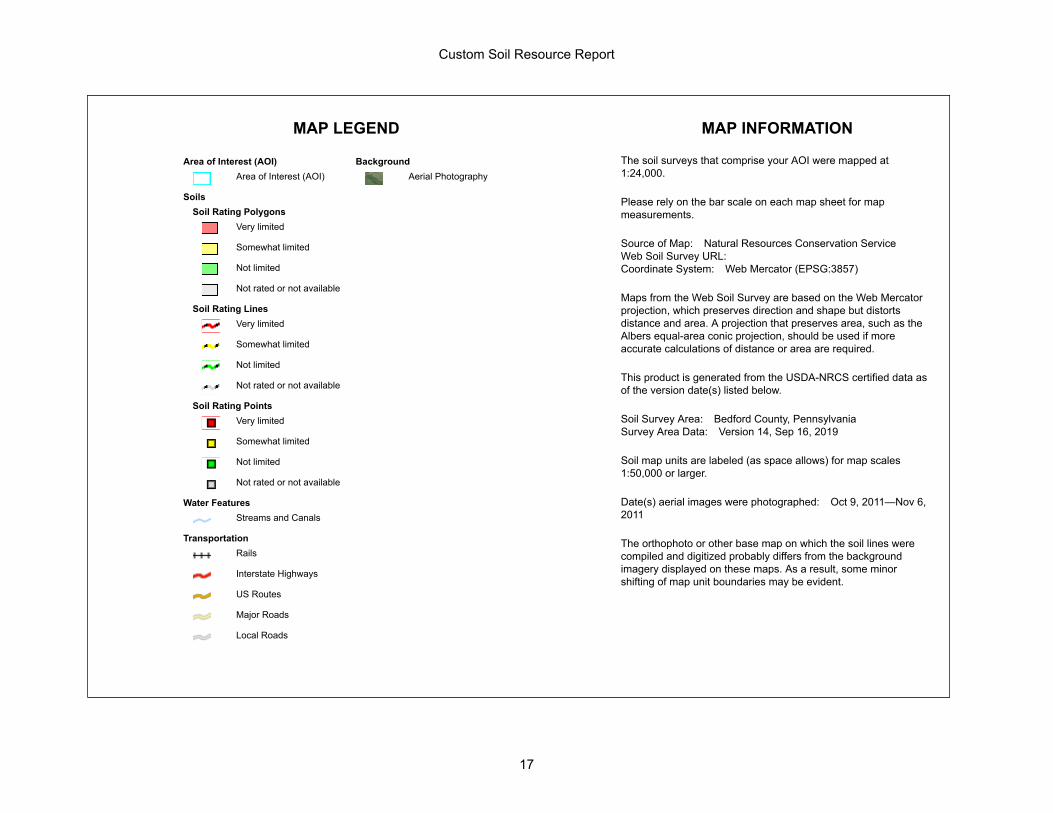
MAP LEGEND MAP INFORMATION
Area of Interest (AOI)Area of Interest (AOI)
SoilsSoil Rating Polygons
Very limited
Somewhat limited
Not limited
Not rated or not available
Soil Rating LinesVery limited
Somewhat limited
Not limited
Not rated or not available
Soil Rating PointsVery limited
Somewhat limited
Not limited
Not rated or not available
Water FeaturesStreams and Canals
TransportationRails
Interstate Highways
US Routes
Major Roads
Local Roads
BackgroundAerial Photography
The soil surveys that comprise your AOI were mapped at 1:24,000.
Please rely on the bar scale on each map sheet for map measurements.
Source of Map: Natural Resources Conservation ServiceWeb Soil Survey URL: Coordinate System: Web Mercator (EPSG:3857)
Maps from the Web Soil Survey are based on the Web Mercator projection, which preserves direction and shape but distorts distance and area. A projection that preserves area, such as the Albers equal-area conic projection, should be used if more accurate calculations of distance or area are required.
This product is generated from the USDA-NRCS certified data as of the version date(s) listed below.
Soil Survey Area: Bedford County, PennsylvaniaSurvey Area Data: Version 14, Sep 16, 2019
Soil map units are labeled (as space allows) for map scales 1:50,000 or larger.
Date(s) aerial images were photographed: Oct 9, 2011—Nov 6, 2011
The orthophoto or other base map on which the soil lines were compiled and digitized probably differs from the background imagery displayed on these maps. As a result, some minor shifting of map unit boundaries may be evident.
Custom Soil Resource Report
17

Tables—Unpaved Local Roads and Streets (SGL 48 Scrub Oak Road)
Map unit symbol
Map unit name Rating Component name (percent)
Rating reasons (numeric values)
Acres in AOI Percent of AOI
DkC Dystrocrepts-Rock outcrop complex, 3 to 15 percent slopes
Somewhat limited
Dystrochrepts (65%)
Slope (0.63) 174.4 58.9%
Large stones (0.01)
Dusty (0.00)
HTC Hazleton-Clymer association, 8 to 25 percent slopes, extremely stony
Very limited Hazleton (45%) Slope (1.00) 121.7 41.1%
Large stones (0.64)
Frost action (0.50)
Dusty (0.01)
Clymer (40%) Slope (1.00)
Frost action (0.50)
Dusty (0.01)
Totals for Area of Interest 296.1 100.0%
Rating Acres in AOI Percent of AOI
Somewhat limited 174.4 58.9%
Very limited 121.7 41.1%
Totals for Area of Interest 296.1 100.0%
Rating Options—Unpaved Local Roads and Streets (SGL 48 Scrub Oak Road)
Aggregation Method: Dominant Condition
Component Percent Cutoff: None Specified
Tie-break Rule: Higher
Custom Soil Resource Report
18

Soil ReportsThe Soil Reports section includes various formatted tabular and narrative reports (tables) containing data for each selected soil map unit and each component of each unit. No aggregation of data has occurred as is done in reports in the Soil Properties and Qualities and Suitabilities and Limitations sections.
The reports contain soil interpretive information as well as basic soil properties and qualities. A description of each report (table) is included.
Building Site Development
This folder contains a collection of tabular reports that present soil interpretations related to building site development. The reports (tables) include all selected map units and components for each map unit, limiting features and interpretive ratings. Building site development interpretations are designed to be used as tools for evaluating soil suitability and identifying soil limitations for various construction purposes. As part of the interpretation process, the rating applies to each soil in its described condition and does not consider present land use. Example interpretations can include corrosion of concrete and steel, shallow excavations, dwellings with and without basements, small commercial buildings, local roads and streets, and lawns and landscaping.
Roads and Streets, Shallow Excavations, and Lawns and Landscaping (SGL 48 Scrub Oak Road)
Soil properties influence the development of building sites, including the selection of the site, the design of the structure, construction, performance after construction, and maintenance. This table shows the degree and kind of soil limitations that affect local roads and streets, shallow excavations, and lawns and landscaping.
The ratings in the table are both verbal and numerical. Rating class terms indicate the extent to which the soils are limited by all of the soil features that affect building site development. Not limited indicates that the soil has features that are very favorable for the specified use. Good performance and very low maintenance can be expected. Somewhat limited indicates that the soil has features that are moderately favorable for the specified use. The limitations can be overcome or minimized by special planning, design, or installation. Fair performance and moderate maintenance can be expected. Very limited indicates that the soil has one or more features that are unfavorable for the specified use. The limitations generally cannot be overcome without major soil reclamation, special design, or expensive installation procedures. Poor performance and high maintenance can be expected.
Numerical ratings in the table indicate the severity of individual limitations. The ratings are shown as decimal fractions ranging from 0.01 to 1.00. They indicate gradations between the point at which a soil feature has the greatest negative impact on the use (1.00) and the point at which the soil feature is not a limitation (0.00).
Custom Soil Resource Report
19

Local roads and streets have an all-weather surface and carry automobile and light truck traffic all year. They have a subgrade of cut or fill soil material; a base of gravel, crushed rock, or soil material stabilized by lime or cement; and a surface of flexible material (asphalt), rigid material (concrete), or gravel with a binder. The ratings are based on the soil properties that affect the ease of excavation and grading and the traffic-supporting capacity. The properties that affect the ease of excavation and grading are depth to bedrock or a cemented pan, hardness of bedrock or a cemented pan, depth to a water table, ponding, flooding, the amount of large stones, and slope. The properties that affect the traffic-supporting capacity are soil strength (as inferred from the AASHTO group index number), subsidence, linear extensibility (shrink-swell potential), the potential for frost action, depth to a water table, and ponding.
Shallow excavations are trenches or holes dug to a maximum depth of 5 or 6 feet for graves, utility lines, open ditches, or other purposes. The ratings are based on the soil properties that influence the ease of digging and the resistance to sloughing. Depth to bedrock or a cemented pan, hardness of bedrock or a cemented pan, the amount of large stones, and dense layers influence the ease of digging, filling, and compacting. Depth to the seasonal high water table, flooding, and ponding may restrict the period when excavations can be made. Slope influences the ease of using machinery. Soil texture, depth to the water table, and linear extensibility (shrink-swell potential) influence the resistance to sloughing.
Lawns and landscaping require soils on which turf and ornamental trees and shrubs can be established and maintained. Irrigation is not considered in the ratings. The ratings are based on the soil properties that affect plant growth and trafficability after vegetation is established. The properties that affect plant growth are reaction; depth to a water table; ponding; depth to bedrock or a cemented pan; the available water capacity in the upper 40 inches; the content of salts, sodium, or calcium carbonate; and sulfidic materials. The properties that affect trafficability are flooding, depth to a water table, ponding, slope, stoniness, and the amount of sand, clay, or organic matter in the surface layer.
Information in this table is intended for land use planning, for evaluating land use alternatives, and for planning site investigations prior to design and construction. The information, however, has limitations. For example, estimates and other data generally apply only to that part of the soil between the surface and a depth of 5 to 7 feet. Because of the map scale, small areas of different soils may be included within the mapped areas of a specific soil.
The information is not site specific and does not eliminate the need for onsite investigation of the soils or for testing and analysis by personnel experienced in the design and construction of engineering works.
Government ordinances and regulations that restrict certain land uses or impose specific design criteria were not considered in preparing the information in this table. Local ordinances and regulations should be considered in planning, in site selection, and in design.
Report—Roads and Streets, Shallow Excavations, and Lawns and Landscaping (SGL 48 Scrub Oak Road)
[Onsite investigation may be needed to validate the interpretations in this table and to confirm the identity of the soil on a given site. The numbers in the value columns range from 0.01 to 1.00. The larger the value, the greater the potential limitation.
Custom Soil Resource Report
20

The table shows only the top five limitations for any given soil. The soil may have additional limitations]
Roads and Streets, Shallow Excavations, and Lawns and Landscaping–Bedford County, Pennsylvania
Map symbol and soil name
Pct. of map unit
Lawns and landscaping Local roads and streets Shallow excavations
Rating class and limiting features
Value Rating class and limiting features
Value Rating class and limiting features
Value
DkC—Dystrocrepts-Rock outcrop complex, 3 to 15 percent slopes
Dystrochrepts 65 Very limited Somewhat limited Somewhat limited
Large stones content 1.00 Slope 0.63 Slope 0.63
Low exchange capacity
0.75 Large stones 0.01 Unstable excavation walls
0.01
Slope 0.63 Large stones 0.01
Gravel content 0.01 Dusty 0.01
Dusty 0.01
HTC—Hazleton-Clymer association, 8 to 25 percent slopes, extremely stony
Hazleton 45 Very limited Very limited Very limited
Large stones content 1.00 Slope 1.00 Slope 1.00
Slope 1.00 Large stones 0.64 Large stones 0.64
Low exchange capacity
0.75 Frost action 0.50 Unstable excavation walls
0.14
Droughty 0.06 Dusty 0.01
Dusty 0.01 Depth to hard bedrock 0.01
Clymer 40 Very limited Very limited Very limited
Large stones content 1.00 Slope 1.00 Slope 1.00
Slope 1.00 Frost action 0.50 Dusty 0.01
Low exchange capacity
0.75 Unstable excavation walls
0.01
Dusty 0.01 Depth to hard bedrock 0.01
Land Management
This folder contains a collection of tabular reports that present soil interpretations related to land management. The reports (tables) include all selected map units and components for each map unit, limiting features and interpretive ratings. Land management interpretations are tools designed to guide the user in evaluating existing conditions in planning and predicting the soil response to various land management practices, for a variety of land uses, including cropland, forestland, hayland, pastureland, horticulture, and rangeland. Example interpretations include suitability for a variety of irrigation practices, log landings, haul roads and major skid
Custom Soil Resource Report
21

trails, equipment operability, site preparation, suitability for hand and mechanical planting, potential erosion hazard associated with various practices, and ratings for fencing and waterline installation.
Hazard of Erosion and Suitability for Roads on Forestland (SGL 48 Scrub Oak Road)
This table can help forestland owners or managers plan the use of soils for wood crops. Interpretive ratings are given for the soils according to the limitations that affect various aspects of forestland management. The ratings are both verbal and numerical.
Numerical ratings in the table indicate the severity of individual limitations. The ratings are shown as decimal fractions ranging from 0.01 to 1.00. They indicate gradations between the point at which a soil feature has the greatest negative impact on the specified aspect of forestland management (1.00) and the point at which the soil feature is not a limitation (0.00).
The paragraphs that follow indicate the soil properties considered in rating the soils. More detailed information about the criteria used in the ratings is available in the National Forestry Manual, which is available in local offices of the Natural Resources Conservation Service or on the Internet.
Ratings in the column hazard of off-road or off-trail erosion are based on slope and on soil erosion factor K. The soil loss is caused by sheet or rill erosion in off-road or off-trail areas where 50 to 75 percent of the surface has been exposed by logging, grazing, mining, or other kinds of disturbance. The hazard is described as slight, moderate, severe, or very severe. A rating of slight indicates that erosion is unlikely under ordinary climatic conditions; moderate indicates that some erosion is likely and that erosion-control measures may be needed; severe indicates that erosion is very likely and that erosion-control measures, including revegetation of bare areas, are advised; and very severe indicates that significant erosion is expected, loss of soil productivity and off-site damage are likely, and erosion-control measures are costly and generally impractical.
Ratings in the column hazard of erosion on roads and trails are based on the soil erosion factor K, slope, and content of rock fragments. The ratings apply to unsurfaced roads and trails. The hazard is described as slight, moderate, or severe. A rating of slight indicates that little or no erosion is likely; moderate indicates that some erosion is likely, that the roads or trails may require occasional maintenance; and that simple erosion-control measures are needed; and severe indicates that significant erosion is expected, that the roads or trails require frequent maintenance, and that costly erosion-control measures are needed.
Ratings in the column suitability for roads (natural surface) are based on slope, rock fragments on the surface, plasticity index, content of sand, the Unified classification, depth to a water table, ponding, flooding, and the hazard of soil slippage. The ratings indicate the suitability for using the natural surface of the soil for roads. The soils are described as well suited, moderately suited, or poorly suited to this use. Well suited indicates that the soil has features that are favorable for the specified kind of roads and has no limitations. Good performance can be expected, and little or no maintenance is needed. Moderately suited indicates that the soil has features that are moderately favorable for the specified kind of roads. One or more soil properties are less than desirable, and fair performance can be expected. Some maintenance is needed. Poorly suited indicates that the soil has one or more
Custom Soil Resource Report
22

properties that are unfavorable for the specified kind of roads. Overcoming the unfavorable properties requires special design, extra maintenance, and costly alteration.
Reference:United States Department of Agriculture, Natural Resources Conservation Service, National forestry manual.
Report—Hazard of Erosion and Suitability for Roads on Forestland (SGL 48 Scrub Oak Road)
[Onsite investigation may be needed to validate the interpretations in this table and to confirm the identity of the soil on a given site. The numbers in the value columns range from 0.01 to 1.00. The larger the value, the greater the potential limitation. The table shows only the top five limitations for any given soil. The soil may have additional limitations]
Hazard of Erosion and Suitability for Roads on Forestland–Bedford County, Pennsylvania
Map symbol and soil name
Pct. of map unit
Hazard of off-road or off-trail erosion
Hazard of erosion on roads and trails
Suitability for roads (natural surface)
Rating class and limiting features
Value Rating class and limiting features
Value Rating class and limiting features
Value
DkC—Dystrocrepts-Rock outcrop complex, 3 to 15 percent slopes
Dystrochrepts 65 Slight Moderate Poorly suited
Slope/erodibility 0.50 Rock fragments 1.00
Slope 0.50
Dusty 0.01
HTC—Hazleton-Clymer association, 8 to 25 percent slopes, extremely stony
Hazleton 45 Moderate Severe Poorly suited
Surface kw times slope times R index
0.46 Slope/erodibility 0.95 Slope 1.00
Rock fragments 0.50
Dusty 0.01
Clymer 40 Slight Severe Poorly suited
Slope/erodibility 0.95 Slope 1.00
Rock fragments 0.50
Low strength 0.50
Dusty 0.01
Custom Soil Resource Report
23

Soil Physical Properties
This folder contains a collection of tabular reports that present soil physical properties. The reports (tables) include all selected map units and components for each map unit. Soil physical properties are measured or inferred from direct observations in the field or laboratory. Examples of soil physical properties include percent clay, organic matter, saturated hydraulic conductivity, available water capacity, and bulk density.
Engineering Properties (SGL 48 Scrub Oak Road)
This table gives the engineering classifications and the range of engineering properties for the layers of each soil in the survey area.
Hydrologic soil group is a group of soils having similar runoff potential under similar storm and cover conditions. The criteria for determining Hydrologic soil group is found in the National Engineering Handbook, Chapter 7 issued May 2007(http://directives.sc.egov.usda.gov/OpenNonWebContent.aspx?content=17757.wba). Listing HSGs by soil map unit component and not by soil series is a new concept for the engineers. Past engineering references contained lists of HSGs by soil series. Soil series are continually being defined and redefined, and the list of soil series names changes so frequently as to make the task of maintaining a single national list virtually impossible. Therefore, the criteria is now used to calculate the HSG using the component soil properties and no such national series lists will be maintained. All such references are obsolete and their use should be discontinued. Soil properties that influence runoff potential are those that influence the minimum rate of infiltration for a bare soil after prolonged wetting and when not frozen. These properties are depth to a seasonal high water table, saturated hydraulic conductivity after prolonged wetting, and depth to a layer with a very slow water transmission rate. Changes in soil properties caused by land management or climate changes also cause the hydrologic soil group to change. The influence of ground cover is treated independently. There are four hydrologic soil groups, A, B, C, and D, and three dual groups, A/D, B/D, and C/D. In the dual groups, the first letter is for drained areas and the second letter is for undrained areas.
The four hydrologic soil groups are described in the following paragraphs:
Group A. Soils having a high infiltration rate (low runoff potential) when thoroughly wet. These consist mainly of deep, well drained to excessively drained sands or gravelly sands. These soils have a high rate of water transmission.
Group B. Soils having a moderate infiltration rate when thoroughly wet. These consist chiefly of moderately deep or deep, moderately well drained or well drained soils that have moderately fine texture to moderately coarse texture. These soils have a moderate rate of water transmission.
Group C. Soils having a slow infiltration rate when thoroughly wet. These consist chiefly of soils having a layer that impedes the downward movement of water or soils of moderately fine texture or fine texture. These soils have a slow rate of water transmission.
Group D. Soils having a very slow infiltration rate (high runoff potential) when thoroughly wet. These consist chiefly of clays that have a high shrink-swell
Custom Soil Resource Report
24

potential, soils that have a high water table, soils that have a claypan or clay layer at or near the surface, and soils that are shallow over nearly impervious material. These soils have a very slow rate of water transmission.
Depth to the upper and lower boundaries of each layer is indicated.
Texture is given in the standard terms used by the U.S. Department of Agriculture. These terms are defined according to percentages of sand, silt, and clay in the fraction of the soil that is less than 2 millimeters in diameter. "Loam," for example, is soil that is 7 to 27 percent clay, 28 to 50 percent silt, and less than 52 percent sand. If the content of particles coarser than sand is 15 percent or more, an appropriate modifier is added, for example, "gravelly."
Classification of the soils is determined according to the Unified soil classification system (ASTM, 2005) and the system adopted by the American Association of State Highway and Transportation Officials (AASHTO, 2004).
The Unified system classifies soils according to properties that affect their use as construction material. Soils are classified according to particle-size distribution of the fraction less than 3 inches in diameter and according to plasticity index, liquid limit, and organic matter content. Sandy and gravelly soils are identified as GW, GP, GM, GC, SW, SP, SM, and SC; silty and clayey soils as ML, CL, OL, MH, CH, and OH; and highly organic soils as PT. Soils exhibiting engineering properties of two groups can have a dual classification, for example, CL-ML.
The AASHTO system classifies soils according to those properties that affect roadway construction and maintenance. In this system, the fraction of a mineral soil that is less than 3 inches in diameter is classified in one of seven groups from A-1 through A-7 on the basis of particle-size distribution, liquid limit, and plasticity index. Soils in group A-1 are coarse grained and low in content of fines (silt and clay). At the other extreme, soils in group A-7 are fine grained. Highly organic soils are classified in group A-8 on the basis of visual inspection.
If laboratory data are available, the A-1, A-2, and A-7 groups are further classified as A-1-a, A-1-b, A-2-4, A-2-5, A-2-6, A-2-7, A-7-5, or A-7-6. As an additional refinement, the suitability of a soil as subgrade material can be indicated by a group index number. Group index numbers range from 0 for the best subgrade material to 20 or higher for the poorest.
Percentage of rock fragments larger than 10 inches in diameter and 3 to 10 inches in diameter are indicated as a percentage of the total soil on a dry-weight basis. The percentages are estimates determined mainly by converting volume percentage in the field to weight percentage. Three values are provided to identify the expected Low (L), Representative Value (R), and High (H).
Percentage (of soil particles) passing designated sieves is the percentage of the soil fraction less than 3 inches in diameter based on an ovendry weight. The sieves, numbers 4, 10, 40, and 200 (USA Standard Series), have openings of 4.76, 2.00, 0.420, and 0.074 millimeters, respectively. Estimates are based on laboratory tests of soils sampled in the survey area and in nearby areas and on estimates made in the field. Three values are provided to identify the expected Low (L), Representative Value (R), and High (H).
Liquid limit and plasticity index (Atterberg limits) indicate the plasticity characteristics of a soil. The estimates are based on test data from the survey area or from nearby areas and on field examination. Three values are provided to identify the expected Low (L), Representative Value (R), and High (H).
References:
Custom Soil Resource Report
25

American Association of State Highway and Transportation Officials (AASHTO). 2004. Standard specifications for transportation materials and methods of sampling and testing. 24th edition.
American Society for Testing and Materials (ASTM). 2005. Standard classification of soils for engineering purposes. ASTM Standard D2487-00.
Custom Soil Resource Report
26

Absence of an entry indicates that the data were not estimated. The asterisk '*' denotes the representative texture; other possible textures follow the dash. The criteria for determining the hydrologic soil group for individual soil components is found in the National Engineering Handbook, Chapter 7 issued May 2007(http://directives.sc.egov.usda.gov/OpenNonWebContent.aspx?content=17757.wba). Three values are provided to identify the expected Low (L), Representative Value (R), and High (H).
Engineering Properties–Bedford County, Pennsylvania
Map unit symbol and soil name
Pct. of map unit
Hydrologic
group
Depth USDA texture Classification Pct Fragments Percentage passing sieve number— Liquid limit
Plasticity index
Unified AASHTO >10 inches
3-10 inches
4 10 40 200
In L-R-H L-R-H L-R-H L-R-H L-R-H L-R-H L-R-H L-R-H
DkC—Dystrocrepts-Rock outcrop complex, 3 to 15 percent slopes
Dystrochrepts 65 A 0-6 Extremely stony sandy loam
CL-ML, GM, ML, SM, SC-SM
A-1, A-2, A-4
6-13- 20 10-18- 25
50-70- 90
45-63- 80
40-58- 75
20-38- 55
15-23 -30
NP-4 -8
6-40 Very channery sandy loam, channery loam
GC-GM, GM, ML, SM
A-1, A-2, A-4
1- 6- 10 5-20- 35 50-68- 85
40-58- 75
40-58- 75
20-38- 55
15-23 -30
NP-4 -8
40-60 Extremely channery loam, very channery sandy loam, extremely channery loamy sand
GP, SM, GC, GM, SC-SM
A-1, A-2, A-4
1- 6- 10 10-25- 40
50-68- 85
25-50- 75
20-43- 65
15-28- 40
15-23 -30
NP-4 -8
60-64 Bedrock — — — — — — — — — —
Custom Soil Resource Report
27
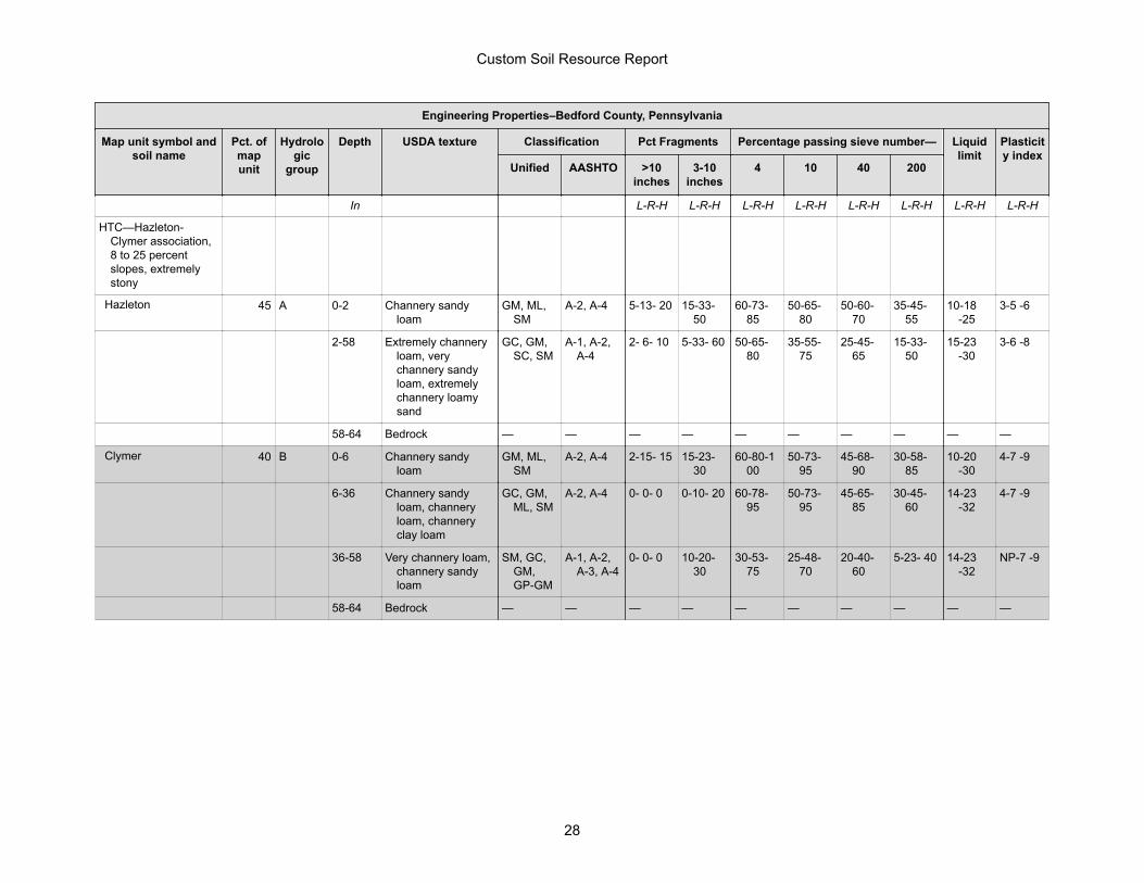
Engineering Properties–Bedford County, Pennsylvania
Map unit symbol and soil name
Pct. of map unit
Hydrologic
group
Depth USDA texture Classification Pct Fragments Percentage passing sieve number— Liquid limit
Plasticity index
Unified AASHTO >10 inches
3-10 inches
4 10 40 200
In L-R-H L-R-H L-R-H L-R-H L-R-H L-R-H L-R-H L-R-H
HTC—Hazleton-Clymer association, 8 to 25 percent slopes, extremely stony
Hazleton 45 A 0-2 Channery sandy loam
GM, ML, SM
A-2, A-4 5-13- 20 15-33- 50
60-73- 85
50-65- 80
50-60- 70
35-45- 55
10-18 -25
3-5 -6
2-58 Extremely channery loam, very channery sandy loam, extremely channery loamy sand
GC, GM, SC, SM
A-1, A-2, A-4
2- 6- 10 5-33- 60 50-65- 80
35-55- 75
25-45- 65
15-33- 50
15-23 -30
3-6 -8
58-64 Bedrock — — — — — — — — — —
Clymer 40 B 0-6 Channery sandy loam
GM, ML, SM
A-2, A-4 2-15- 15 15-23- 30
60-80-100
50-73- 95
45-68- 90
30-58- 85
10-20 -30
4-7 -9
6-36 Channery sandy loam, channery loam, channery clay loam
GC, GM, ML, SM
A-2, A-4 0- 0- 0 0-10- 20 60-78- 95
50-73- 95
45-65- 85
30-45- 60
14-23 -32
4-7 -9
36-58 Very channery loam, channery sandy loam
SM, GC, GM, GP-GM
A-1, A-2, A-3, A-4
0- 0- 0 10-20- 30
30-53- 75
25-48- 70
20-40- 60
5-23- 40 14-23 -32
NP-7 -9
58-64 Bedrock — — — — — — — — — —
Custom Soil Resource Report
28

Physical Soil Properties (SGL 48 Scrub Oak Road)
This table shows estimates of some physical characteristics and features that affect soil behavior. These estimates are given for the layers of each soil in the survey area. The estimates are based on field observations and on test data for these and similar soils.
Depth to the upper and lower boundaries of each layer is indicated.
Particle size is the effective diameter of a soil particle as measured by sedimentation, sieving, or micrometric methods. Particle sizes are expressed as classes with specific effective diameter class limits. The broad classes are sand, silt, and clay, ranging from the larger to the smaller.
Sand as a soil separate consists of mineral soil particles that are 0.05 millimeter to 2 millimeters in diameter. In this table, the estimated sand content of each soil layer is given as a percentage, by weight, of the soil material that is less than 2 millimeters in diameter.
Silt as a soil separate consists of mineral soil particles that are 0.002 to 0.05 millimeter in diameter. In this table, the estimated silt content of each soil layer is given as a percentage, by weight, of the soil material that is less than 2 millimeters in diameter.
Clay as a soil separate consists of mineral soil particles that are less than 0.002 millimeter in diameter. In this table, the estimated clay content of each soil layer is given as a percentage, by weight, of the soil material that is less than 2 millimeters in diameter.
The content of sand, silt, and clay affects the physical behavior of a soil. Particle size is important for engineering and agronomic interpretations, for determination of soil hydrologic qualities, and for soil classification.
The amount and kind of clay affect the fertility and physical condition of the soil and the ability of the soil to adsorb cations and to retain moisture. They influence shrink-swell potential, saturated hydraulic conductivity (Ksat), plasticity, the ease of soil dispersion, and other soil properties. The amount and kind of clay in a soil also affect tillage and earthmoving operations.
Moist bulk density is the weight of soil (ovendry) per unit volume. Volume is measured when the soil is at field moisture capacity, that is, the moisture content at 1/3- or 1/10-bar (33kPa or 10kPa) moisture tension. Weight is determined after the soil is dried at 105 degrees C. In the table, the estimated moist bulk density of each soil horizon is expressed in grams per cubic centimeter of soil material that is less than 2 millimeters in diameter. Bulk density data are used to compute linear extensibility, shrink-swell potential, available water capacity, total pore space, and other soil properties. The moist bulk density of a soil indicates the pore space available for water and roots. Depending on soil texture, a bulk density of more than 1.4 can restrict water storage and root penetration. Moist bulk density is influenced by texture, kind of clay, content of organic matter, and soil structure.
Saturated hydraulic conductivity (Ksat) refers to the ease with which pores in a saturated soil transmit water. The estimates in the table are expressed in terms of micrometers per second. They are based on soil characteristics observed in the field, particularly structure, porosity, and texture. Saturated hydraulic conductivity (Ksat) is considered in the design of soil drainage systems and septic tank absorption fields.
Custom Soil Resource Report
29

Available water capacity refers to the quantity of water that the soil is capable of storing for use by plants. The capacity for water storage is given in inches of water per inch of soil for each soil layer. The capacity varies, depending on soil properties that affect retention of water. The most important properties are the content of organic matter, soil texture, bulk density, and soil structure. Available water capacity is an important factor in the choice of plants or crops to be grown and in the design and management of irrigation systems. Available water capacity is not an estimate of the quantity of water actually available to plants at any given time.
Linear extensibility refers to the change in length of an unconfined clod as moisture content is decreased from a moist to a dry state. It is an expression of the volume change between the water content of the clod at 1/3- or 1/10-bar tension (33kPa or 10kPa tension) and oven dryness. The volume change is reported in the table as percent change for the whole soil. The amount and type of clay minerals in the soil influence volume change.
Linear extensibility is used to determine the shrink-swell potential of soils. The shrink-swell potential is low if the soil has a linear extensibility of less than 3 percent; moderate if 3 to 6 percent; high if 6 to 9 percent; and very high if more than 9 percent. If the linear extensibility is more than 3, shrinking and swelling can cause damage to buildings, roads, and other structures and to plant roots. Special design commonly is needed.
Organic matter is the plant and animal residue in the soil at various stages of decomposition. In this table, the estimated content of organic matter is expressed as a percentage, by weight, of the soil material that is less than 2 millimeters in diameter. The content of organic matter in a soil can be maintained by returning crop residue to the soil.
Organic matter has a positive effect on available water capacity, water infiltration, soil organism activity, and tilth. It is a source of nitrogen and other nutrients for crops and soil organisms.
Erosion factors are shown in the table as the K factor (Kw and Kf) and the T factor. Erosion factor K indicates the susceptibility of a soil to sheet and rill erosion by water. Factor K is one of six factors used in the Universal Soil Loss Equation (USLE) and the Revised Universal Soil Loss Equation (RUSLE) to predict the average annual rate of soil loss by sheet and rill erosion in tons per acre per year. The estimates are based primarily on percentage of silt, sand, and organic matter and on soil structure and Ksat. Values of K range from 0.02 to 0.69. Other factors being equal, the higher the value, the more susceptible the soil is to sheet and rill erosion by water.
Erosion factor Kw indicates the erodibility of the whole soil. The estimates are modified by the presence of rock fragments.
Erosion factor Kf indicates the erodibility of the fine-earth fraction, or the material less than 2 millimeters in size.
Erosion factor T is an estimate of the maximum average annual rate of soil erosion by wind and/or water that can occur without affecting crop productivity over a sustained period. The rate is in tons per acre per year.
Wind erodibility groups are made up of soils that have similar properties affecting their susceptibility to wind erosion in cultivated areas. The soils assigned to group 1 are the most susceptible to wind erosion, and those assigned to group 8 are the least susceptible. The groups are described in the "National Soil Survey Handbook."
Custom Soil Resource Report
30

Wind erodibility index is a numerical value indicating the susceptibility of soil to wind erosion, or the tons per acre per year that can be expected to be lost to wind erosion. There is a close correlation between wind erosion and the texture of the surface layer, the size and durability of surface clods, rock fragments, organic matter, and a calcareous reaction. Soil moisture and frozen soil layers also influence wind erosion.
Reference:United States Department of Agriculture, Natural Resources Conservation Service. National soil survey handbook, title 430-VI. (http://soils.usda.gov)
Custom Soil Resource Report
31

Three values are provided to identify the expected Low (L), Representative Value (R), and High (H).
Physical Soil Properties–Bedford County, Pennsylvania
Map symbol and soil name
Depth Sand Silt Clay Moist bulk
density
Saturated hydraulic
conductivity
Available water
capacity
Linear extensibility
Organic matter
Erosion factors
Wind erodibility
group
Wind erodibility
indexKw Kf T
In Pct Pct Pct g/cc micro m/sec In/In Pct Pct
DkC—Dystrocrepts-Rock outcrop complex, 3 to 15 percent slopes
Dystrochrepts 0-6 -68- -20- 7-13- 18 1.20-1.35-1.50
42.34-91.74-141.14
0.08-0.10-0.12
0.0- 1.5- 2.9 2.0- 3.0- 4.0
.02 .10 5 8 0
6-40 -68- -20- 7-13- 18 1.20-1.35-1.50
42.34-91.74-141.14
0.08-0.10-0.12
0.0- 1.5- 2.9 0.0- 0.3- 0.5
.05 .20
40-60 -46- -44- 5-10- 15 1.20-1.35-1.50
42.34-91.74-141.14
0.05-0.08-0.10
0.0- 1.5- 2.9 0.0- 0.3- 0.5
.10 .43
60-64 — — — — — — — —
Custom Soil Resource Report
32

Physical Soil Properties–Bedford County, Pennsylvania
Map symbol and soil name
Depth Sand Silt Clay Moist bulk
density
Saturated hydraulic
conductivity
Available water
capacity
Linear extensibility
Organic matter
Erosion factors
Wind erodibility
group
Wind erodibility
indexKw Kf T
In Pct Pct Pct g/cc micro m/sec In/In Pct Pct
HTC—Hazleton-Clymer association, 8 to 25 percent slopes, extremely stony
Hazleton 0-2 -68- -20- 7-13- 18 1.20-1.30-1.40
14.11-28.23-42.34
0.10-0.13-0.16
0.0- 1.5- 2.9 2.0- 3.0- 4.0
.05 .15 3 5 56
2-58 -46- -44- 5-10- 15 1.20-1.30-1.40
14.11-77.63-141.14
0.06-0.09-0.12
0.0- 1.5- 2.9 0.0- 0.3- 0.5
.10 .43
58-64 — — — — 3.00-28.23-42.34
— — —
Clymer 0-6 35-64- 70 15-20- 45 15-16- 27 1.20-1.30-1.40
4.23-9.17-14.11 0.10-0.13-0.16
0.0- 1.5- 2.9 2.0- 3.0- 4.0
.05 .15 3 5 56
6-36 -51- -29- 18-20- 30 1.20-1.35-1.50
4.23-9.17-14.11 0.08-0.11-0.14
0.0- 1.5- 2.9 0.0- 0.3- 0.5
.15 .32
36-58 -42- -37- 15-21- 27 1.20-1.30-1.40
4.23-9.17-14.11 0.04-0.06-0.08
0.0- 1.5- 2.9 0.0- 0.3- 0.5
.10 .37
58-64 — — — — 14.11-28.23-42.34
— — —
Custom Soil Resource Report
33

Contract No. PGC-048-20-01
TS-6-1
TECHNICAL SPECIFICATION SECTION 6 - SEEDING 6.1 - SCOPE This work is securing a satisfactory stand of grass and permanent stabilization at disturbed areas or where directed by the PGC, and includes preparation of the seed bed, furnishing and placing lime and fertilizer, furnishing and sowing of seed, mulching, and maintaining and tending the seeded areas. 6.2 - APPLICABLE PUBLICATIONS AND REFERENCES Bulletin 15 - Approved Construction Materials, Pennsylvania Department of Transportation. Publication 408 - Specifications, Pennsylvania Department of Transportation. 6.3 - MATERIALS A - Grass Seed – As shown and specified on the Drawings. Other similar mixes may be proposed subject to the approval of PGC staff and provided proposed mixes provide effective stabilization and protection against accelerated erosion, promote improved wildlife habitat, and are consistent with the project requirements and PGC wildlife habitat management best practices. Seed mixes SHALL NOT include annual or perennial rye, wildrye, or fescue variety grass seeds. Deliver premixed seed in bags or other suitable containers, each fully labeled with the name, trademark, and warranty of the producer and with the mixture type, weed seed percentage, purity percentage, germination percentage, and mix formula or composition. Do not use seed which has become wet, moldy, or otherwise damaged in transit or storage, has a mix date older than 9 months prior to seeding, or has a test date older than 6 months prior to seeding. B - Fertilizer – If required and specified, use dry formulation of 10-20-20-analysis. Fertilizer shall be delivered in bags or other suitable containers, each fully labeled and bearing the name, trademark, and warranty of the producer. C - Lime - If required and specified, lime application shall conform to Section 804.2(a).1 of Pub.408. D – Inoculant – If required and specified, provide in accordance with Section 804.2(c) of Pub. 408. E - Mulches - Mulches shall be free from mature seedbearing stalks or roots of prohibited or noxious weeds as defined by law. Do not use mulches which are cut into lengths of less than 6 inches.

Contract No. PGC-048-20-01
TS-6-2
Mulches shall be either one or a combination of the following, shall contain no stems of tobacco, soybeans, or other coarse or woody materials. 1. - Straw - Either wheat or oat straw, and free of weeds and viable seeds, well-cured to less than 20 percent moisture content by weight, not chopped or finely broken. 2. - Wood Fiber - Use wood fiber meeting the requirements of Section 805.2(a).1.c of Pub. 408. 3. - Pellet Mulch - Use pellet mulch meeting the requirements of Section 805.2(a).1.d of Pub. 408. F - Mulch Binders - Use one of the following mulch binders in accordance with Section 805.2(b) of Pub. 408. Use Recycled Cellulose Fiber, Wood Fiber, Non-asphaltic Emulsion, Polyvinyl Acetate, or a Mixture of Recycled Cellulose Wood Fiber and Wood Fiber. Obtain binders from a producer listed in Bulletin 15. G - Water - Water shall be fresh and free from injurious amounts of oil, acid, alkali, salts, or other materials harmful to the growth of grass. H – Topsoil - Acceptable friable loam that is reasonably free of subsoil, clay lumps, brush, roots, weeds, other objectionable vegetation, stones, other foreign material larger than 2 inches in any dimension, litter, and/or other material unsuitable or harmful to plant growth in accordance with Section 801.2 (a) and 802.2 of Pub. 408. 6.4 - PROCEDURE Follow the procedures specified below and as listed in Section 804.3 of Pub. 408. The amounts of seed, lime, fertilizer and mulch specified are the minimum acceptable. Employ modifications if they are deemed necessary, at no additional cost to the PGC, and accept full responsibility for obtaining a satisfactory stand of grass. A – Topsoil Furnished and Placed – Reference Section 802 of Pub. 408. Provide topsoil as shown on the drawings and as required to restore disturbed areas. Grade the areas to be covered by topsoil. Using acceptable methods, loosen soil to a depth of 2 inches before placing the topsoil. Remove stones and other foreign material 2 inches or larger in any dimension. Remove and satisfactorily dispose of unsuitable and surplus material. Place topsoil on the prepared areas and, unless otherwise indicated, spread and compact to a 4-inch uniform depth ±1 1/2 inches. Compact with a roller having a weight not over 120 pounds per foot width of roller or by other acceptable methods, as directed. Remove over-depth topsoil, unless otherwise agreed upon in writing. Do not place topsoil in a wet or frozen condition. B - Sowing - Sow the seed mixture on a still day at a rate specified in Section 804.2 of Pub. 408. Sow by hand or by approved sowing equipment in 2 applications, one-half the seed while the seeder is traveling in one direction and the other half while the seeder is traveling at right angle to the first direction. After sowing, rake, cultipack, or brush drag the surface very lightly, just deep enough to cover the seeds. Rake only in a direction parallel to the contour lines.
Contract No. PGC-048-20-01
TS-6-3
C - Mulching - After sowing is completed, spread mulch uniformly over the entire seeded area at a rate of 3 tons (dry weight) per acre. The mulch shall be moist at the time of placement. Apply wood fiber mulch hydraulically in accordance with the manufacturer's tank-mixing instructions. Wood fiber mulch may be incorporated into the slurry after the seed and soil supplements have been thoroughly mixed. Apply wood fiber mulch at a rate of 800 Lbs. per acre unless otherwise indicated by the manufacturer. On slopes 6:1 or flatter, apply pellet mulch by hand or using a mechanical spreader immediately after seeding, at a rate of 2,615 Lbs. per acre. Thoroughly wet pellet mulch with water without dislodging mulch. To prevent loss or bunching by wind and to form a soil-binding mulch, anchor the moist mulch to the soil with a mulch binder. Use mulch binders at the following rates: Recycled Cellulose Fiber - 775 Lbs./Acre Wood Fiber - 775 Lbs./Acre Mixture of Recycled Cellulose Fiber and Wood Fiber - 775 Lbs./Acre Non-asphaltic Emulsion - Manufacturer's Recommended Rate Polyvinyl Acetate - Manufacturer's Recommended Rate On slopes where machinery cannot be used, retain the mulch in place by some suitable means which will not be detrimental to subsequent operations. 6.5 - MAINTENANCE At no additional cost to the PGC, maintain the seeded areas until all work under the Contract has been completed and accepted by the PGC. Maintenance shall include refilling rain-washed gullies, reseeding, reapplying fertilizer, lime and mulch, and removal of large and noxious weeds, as directed by the PGC. 6.6 - MEASUREMENT AND PAYMENT None – No separate payment will be made for this item. This work shall be considered incidental to the other items of work in the project and included in the Bid and will not be measured and paid for separately.


![Imperata brasiliensis, I. cylindrica - InvasiveK115 Sand pine scrub K116 Subtropical pine forest SAF COVER TYPES [38]: 69 Sand pine 70 Longleaf pine 71 Longleaf pine-scrub oak 74 Cabbage](https://static.fdocuments.net/doc/165x107/5e50a01de48dec6cdb2ff813/imperata-brasiliensis-i-cylindrica-invasive-k115-sand-pine-scrub-k116-subtropical.jpg)