PennDOT Memo Template Daniele Spila, Director, Policy Office William Cressler, Office of Chief...
78
OS-600 (11-08) www.dot.state.pa.us Highway Administration | 400 North St, 8 th Floor | Harrisburg, PA 17105 | 717·787·6875 MEMO 470-09-4 DATE: February 12, 2009 SUBJECT: SOL on Transportation Impact Study Guidelines TO: District Executives FROM: Richard H. Hogg, P.E. /s/ Deputy Secretary for Highway Administration The Transportation Impact Study (TIS) Guidelines used in the Department’s highway occupancy permit (HOP) program for driveways and local roads is being modified as part of a general review of this program. This strike-off letter is intended to modify the Department’s current policies and procedures as it relates to the preparation and review of TIS reports. Along with incorporating Smart Transportation, the guidelines were modified based on three major areas of concern: Mitigation, Local Inclusiveness, and Timely Delivery. The revisions are meant to create a positive effect on development by encouraging other modes of transportation, providing flexibility in design, encouraging redevelopment, linking local communities and the land development process to the HOP program, as well as providing a document that will promote consistency throughout the Commonwealth. The TIS is an integral step in the HOP process. To improve and maintain consistency throughout the Commonwealth, it is imperative that each submitted TIS complies with these guidelines and conforms to the presentation format established in Appendix C of the guidelines. The following attached TIS Guidelines will replace the current guidelines in its entirety. The new guidelines shall be implemented on projects where a TIS Scoping Meeting has not yet been conducted and, if the applicant so chooses, can be implemented on any project that has not yet received a highway occupancy permit. The TIS Guidelines will be incorporated into the HOP Manual (Publication 170) and HOP Guidelines (Publication 282) with the next revisions to these manuals. The guidelines will be incorporated into Publication 170 as Appendix B and will be replacing Appendix B-2 (TIS Scoping Meeting Criteria (Overview)) in Publication 282. Additionally, since a scoping meeting application and agenda is included in the appendix of the TIS Guidelines, Appendix B-3 (TIS Scoping Meeting Checklist) is being deleted from Publication 282 with this strike-off letter. If you have any questions in regard to the attached policy, please contact Glenn C. Rowe, P.E., PTOE, Acting Director, Bureau of Highway Safety and Traffic Engineering, at (717) 787-7350. Attachment
-
Upload
nguyenkien -
Category
Documents
-
view
215 -
download
2
Transcript of PennDOT Memo Template Daniele Spila, Director, Policy Office William Cressler, Office of Chief...
OS-600 (11-08)
www.dot.state.pa.us
Highway Administration | 400 North St, 8th Floor | Harrisburg, PA 17105 | 717·787·6875
MEMO 470-09-4 DATE: February 12, 2009 SUBJECT: SOL on Transportation Impact Study Guidelines TO: District Executives FROM: Richard H. Hogg, P.E. /s/ Deputy Secretary for Highway Administration The Transportation Impact Study (TIS) Guidelines used in the Department’s highway occupancy permit (HOP) program for driveways and local roads is being modified as part of a general review of this program. This strike-off letter is intended to modify the Department’s current policies and procedures as it relates to the preparation and review of TIS reports. Along with incorporating Smart Transportation, the guidelines were modified based on three major areas of concern: Mitigation, Local Inclusiveness, and Timely Delivery.
The revisions are meant to create a positive effect on development by encouraging other modes of transportation, providing flexibility in design, encouraging redevelopment, linking local communities and the land development process to the HOP program, as well as providing a document that will promote consistency throughout the Commonwealth.
The TIS is an integral step in the HOP process. To improve and maintain consistency throughout the Commonwealth, it is imperative that each submitted TIS complies with these guidelines and conforms to the presentation format established in Appendix C of the guidelines.
The following attached TIS Guidelines will replace the current guidelines in its entirety. The new guidelines shall be implemented on projects where a TIS Scoping Meeting has not yet been conducted and, if the applicant so chooses, can be implemented on any project that has not yet received a highway occupancy permit. The TIS Guidelines will be incorporated into the HOP Manual (Publication 170) and HOP Guidelines (Publication 282) with the next revisions to these manuals. The guidelines will be incorporated into Publication 170 as Appendix B and will be replacing Appendix B-2 (TIS Scoping Meeting Criteria (Overview)) in Publication 282. Additionally, since a scoping meeting application and agenda is included in the appendix of the TIS Guidelines, Appendix B-3 (TIS Scoping Meeting Checklist) is being deleted from Publication 282 with this strike-off letter.
If you have any questions in regard to the attached policy, please contact Glenn C. Rowe, P.E., PTOE, Acting Director, Bureau of Highway Safety and Traffic Engineering, at (717) 787-7350. Attachment
CC: Daniele Spila, Director, Policy Office William Cressler, Office of Chief Counsel Tom Haist, Office of Chief Counsel All Highway Administration Bureau Directors All ADE, Maintenance ADE, Construction, District 8-0 ADE, Services, District 6-0 All District Permit Managers All District Traffic Engineers Jeff Roback, Field Operations & Special Projects, Bureau of Municipal Services Stephen Heil, Paperwork Management Unit, Bureau of Office Services All BHSTE Division Chiefs Mike Dzurko, BHSTE Director’s Correspondence File HOP read file
January 28, 2009
POLICIES AND PROCEDURES FOR TRANSPORTATION IMPACT
STUDIES Related to Highway Occupancy Permits
Pennsylvania Department of Transportation
Bureau of Highway Safety and Traffic Engineering
Prepared for:
Bureau of Highway Safety and Traffic Engineering PO Box 2047 Harrisburg, PA 17105
Policies and Procedures Transportation Impact Guidelines - i -
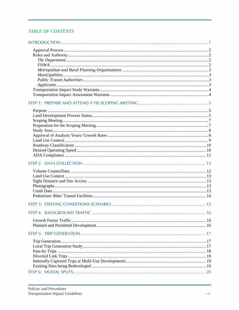
TABLE OF CONTENTS
INTRODUCTION............................................................................................................................. 1
Approval Process...................................................................................................................................... 2 Roles and Authority.................................................................................................................................. 2
The Department....................................................................................................................................2 FHWA...................................................................................................................................................2 Metropolitan and Rural Planning Organizations ................................................................................ 3 Municipalities....................................................................................................................................... 3 Public Transit Authorities .................................................................................................................... 3 Applicants............................................................................................................................................. 3
Transportation Impact Study Warrants..................................................................................................... 4 Transportation Impact Assessment Warrants ........................................................................................... 4
STEP 1: PREPARE AND ATTEND A TIS SCOPING MEETING........................................................... 5
Purpose ..................................................................................................................................................... 5 Land Development Process Status............................................................................................................ 5 Scoping Meeting....................................................................................................................................... 7 Preparation for the Scoping Meeting........................................................................................................ 7 Study Area ................................................................................................................................................ 8 Approval of Analysis Years/ Growth Rates ............................................................................................. 8 Land Use Context ..................................................................................................................................... 9 Roadway Classification .......................................................................................................................... 10 Desired Operating Speed ........................................................................................................................ 10 ADA Compliance ................................................................................................................................... 11
STEP 2: DATA COLLECTION ........................................................................................................ 12
Volume Counts/Data .............................................................................................................................. 12 Land Use Context ................................................................................................................................... 13 Sight Distance and Site Access .............................................................................................................. 13 Photographs ............................................................................................................................................ 13 Crash Data .............................................................................................................................................. 13 Pedestrian/ Bike/ Transit Facilities......................................................................................................... 14
STEP 3: EXISTING CONDITIONS SCENARIO................................................................................ 15
STEP 4: BACKGROUND TRAFFIC ................................................................................................. 16
Growth Factor Traffic............................................................................................................................. 16 Planned and Permitted Development...................................................................................................... 16
STEP 5: TRIP GENERATION .......................................................................................................... 17
Trip Generation....................................................................................................................................... 17 Local Trip Generation Study .................................................................................................................. 17 Pass-by Trips .......................................................................................................................................... 18 Diverted Link Trips ................................................................................................................................ 19 Internally Captured Trips at Multi-Use Developments .......................................................................... 19 Existing Sites being Redeveloped .......................................................................................................... 19
STEP 6: MODAL SPLITS ................................................................................................................ 20
Policies and Procedures Transportation Impact Guidelines - ii -
Standard Assumptions for Alternative Trips .......................................................................................... 20 Residential Land Use.............................................................................................................................. 21 Business Land Use.................................................................................................................................. 22
STEP 7: TRIP DISTRIBUTION ........................................................................................................ 25
STEP 8: TRAFFIC ASSIGNMENT .................................................................................................... 26
STEP 9: FUTURE ANALYSIS........................................................................................................... 27
Without Development Future Year .................................................................................................... 27 With Development Future Year ......................................................................................................... 27
STEP 10: LEVEL OF SERVICE (LOS) REQUIREMENTS .................................................................... 29
Application of 10-Second Variance........................................................................................................ 29 Existing Signalized Intersections............................................................................................................ 30 Existing Unsignalized Intersections ....................................................................................................... 30 New Intersections / Driveways............................................................................................................... 31
STEP 11: MITIGATION ANALYSIS ................................................................................................. 33
Condition 1: Marginal LOS Degradation, Local Land Use and Transportation Plan ............................ 34 Condition 2: Significant LOS Degradation, Alternative Transportation Plan........................................ 34
Alternative Transportation Plan ......................................................................................................... 34 Condition 3: Design Waiver – LOS........................................................................................................ 35 Mitigation Strategies............................................................................................................................... 35
Traffic Signals .................................................................................................................................... 36 Method of Analysis........................................................................................................................ 36 Technology and Maintenance Issues ............................................................................................. 37
Roundabouts....................................................................................................................................... 37
STEP 12: SUBMISSION TO THE DEPARTMENT AND REVIEW PROCESS ..................................... 38
General Formatting................................................................................................................................. 38 Special Review................................................................................................................................... 38 The Department Review Process ....................................................................................................... 38
I. REFERENCES....................................................................................................................................... 1
A. APPENDIX A: GLOSSARY .............................................................................................................A-1
B. APPENDIX B: SCOPING MEETING APPLICATION & AGENDA ............................................. B-1
C. APPENDIX C: SAMPLE TIS............................................................................................................ C-1
D. APPENDIX D: GAP, QUEUE AND TRAVEL TIME STUDIES ....................................................D-1
E. APPENDIX E: ALTERNATIVE TRANSPORTATION PLAN STRATEGIES .............................. E-1
Policies and Procedures Transportation Impact Guidelines - 1 -
INTRODUCTION State highway law and Department regulations support mobility needs of the traveling public, which are balanced with the needs of property owners accessing the State highway right-of-way.
Department regulation governing access to and occupancy of State highway, Title 67 PA Code Chapter 441, Access to and Occupancy of Highways by Driveways and Local Roads, provide the Department with regulatory authority to ensure the location and design of access driveways and local roads within State highway right-of-way preserve safe and reasonable access.
The Department has established a Highway Occupancy Permit (HOP) Process to assist the Department in regulating design construction, location, maintenance and drainage of access driveways for the safety and welfare of the traveling public.1 The Department has regulatory authority to make such investigations and require such additional information as it deems necessary from property owners requesting access to the state highway system.2
As part of the HOP process, applicants may be tasked with identifying impacts of the proposed access on the transportation system in the surrounding area, and identifying mitigations to offset that impact through development of a Transportation Impact Study (TIS) or a Transportation Impact Assessment (TIA).
1 67 Pa. Code§441.2(a) and Wolf vs. Department of Highways
422 Pa 34.22 A 2d 868 (Pa Supreme Ct. 1966). 2 67 Pa. Code§441.3(k)
Once a TIS or TIA is determined to be necessary in the HOP process, the Department will review it in accordance with these guidelines, Department regulations governing access to and occupancy of highways by driveways and local roads, and the requirements of the Municipalities Planning Code (MPC)). The MPC requires the Department to approve, reject or return the study submitted by the applicant as part of the permit application, for additional information in accordance with the established time period.3 The regulations allow the Department to reject any study submitted for review if it is not satisfied with its genuineness, regularity or legality.4
The Department reviews the TIS or TIA to assure safe and reasonable access as well as safe and convenient passage of traffic on the State highway and to ensure that access driveways safely and efficiently function as an integral component of the highway system based on the amount and type of traffic expected to be served and the type and character of roadway being accessed.5 The Department will use the TIS or TIA to provide direction to the applicant on needed improvements.
The purpose of these Guidelines is to provide direction to the applicant on the requirements of the TIS or TIA, and how it will be used by the Department and other levels of government involved in the development review process. The ultimate goal of the process is a safe and efficient transportation system.
3 53 P.S. §10508 4 67 Pa. Code§441.3(k) 5 67 Pa. Code§441.2(a) & 67 Pa. Code 441.8(a)(1)
Policies and Procedures Transportation Impact Guidelines - 2 -
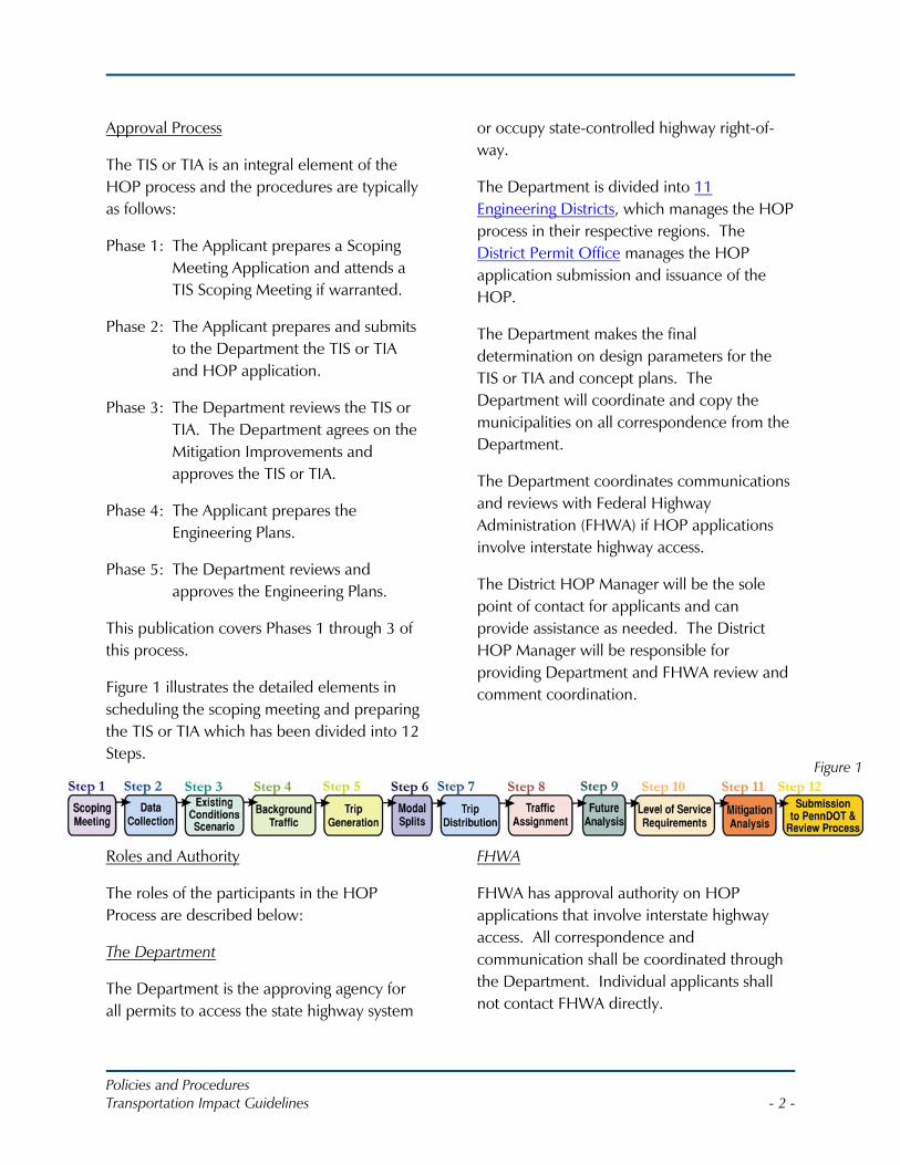
Figure 1
Approval Process
The TIS or TIA is an integral element of the HOP process and the procedures are typically as follows:
Phase 1: The Applicant prepares a Scoping Meeting Application and attends a TIS Scoping Meeting if warranted.
Phase 2: The Applicant prepares and submits to the Department the TIS or TIA and HOP application.
Phase 3: The Department reviews the TIS or TIA. The Department agrees on the Mitigation Improvements and approves the TIS or TIA.
Phase 4: The Applicant prepares the Engineering Plans.
Phase 5: The Department reviews and approves the Engineering Plans.
This publication covers Phases 1 through 3 of this process.
Figure 1 illustrates the detailed elements in scheduling the scoping meeting and preparing the TIS or TIA which has been divided into 12 Steps.
Roles and Authority
The roles of the participants in the HOP Process are described below:
The Department
The Department is the approving agency for all permits to access the state highway system
or occupy state-controlled highway right-of-way.
The Department is divided into 11 Engineering Districts, which manages the HOP process in their respective regions. The District Permit Office manages the HOP application submission and issuance of the HOP.
The Department makes the final determination on design parameters for the TIS or TIA and concept plans. The Department will coordinate and copy the municipalities on all correspondence from the Department.
The Department coordinates communications and reviews with Federal Highway Administration (FHWA) if HOP applications involve interstate highway access.
The District HOP Manager will be the sole point of contact for applicants and can provide assistance as needed. The District HOP Manager will be responsible for providing Department and FHWA review and comment coordination.
FHWA
FHWA has approval authority on HOP applications that involve interstate highway access. All correspondence and communication shall be coordinated through the Department. Individual applicants shall not contact FHWA directly.
Policies and Procedures Transportation Impact Guidelines - 3 -
Metropolitan and Rural Planning Organizations
Metropolitan Planning Organizations (MPO) and Rural Planning Organizations (RPO) have a role in providing information to the applicant and Department regarding planned projects, visioning, and future growth. MPO’s will typically be involved in projects that have multi-municipal impacts.
Municipalities
Municipalities control the land development approval and zoning process. As described in these guidelines, municipalities are invited and encouraged to participate in the review of HOP applications within their jurisdictions.
Municipalities will have opportunity to provide input on mitigation strategies as well as concurrence on Alternative Transportation Plans through the HOP process.
Municipalities are asked to coordinate subdivision and land development approvals with the District Permit Office.
Public Transit Authorities
Local transit authorities operate public transportation systems across the Commonwealth. They will be involved in the review process should the Department, municipality or MPO/RPO determine that the applicant’s project impacts the operation of the transit system; that applicant’s project could be designed to accommodate public transit; or the mitigation of site impacts involves the improvement to the public transit system.
Applicants
The applicant is responsible for preparing an HOP application and TIS or TIA consistent with these guidelines. Changes to the
proposed use, site layout or other planned elements of the project should be communicated to the Department and updates to the HOP application or TIS/TIA will be required when necessary.
The applicant is responsible for all data collection efforts, and assessing the overall impact that the development will have on the transportation system and developing realistic improvements that mitigate impacts.
The TIS or TIA must be conducted under the supervision of a person who possesses a current Professional Engineer’s (PE) license issued by the Pennsylvania Department of State and preferably possessing a Professional Traffic Operations Engineer (PTOE) certificate. The TIS must be signed and sealed by a PE licensed in Pennsylvania.
Applicants are requested to design their site plan so impacts are consistent with local and regional transportation planning efforts, through sound land use and congestion management practices. Applicants are responsible for notifying the municipality, local transit authorities, and MPO or RPO of the status of the HOP application as well as inviting them to Department meetings and ensuring they are copied on any correspondence to the Department. The Department may request evidence that the location and type of highway access has been reviewed by the municipality as outlined in 67 Pa Code Section 441.7.
The applicant should be prepared to explain how the project advances the municipality comprehensive plan land use and transportation goals.
Beyond the technical requirements, applicants should be mindful of Pennsylvania’s Smart
Policies and Procedures Transportation Impact Guidelines - 4 -
Growth and Smart Transportation initiatives. The principles of these initiatives are reflected in the TIS Guidelines.
Transportation Impact Study Warrants
The Department requires a TIS for all HOP applications meeting any one of the following characteristics:
• The site is expected to generate 3,000 or more average daily trips or 1,500 vehicles per day.
• During any one hour time period of any day of the week, the development is expected to generate 100 or more vehicle trips entering the development or 100 or more vehicle trips exiting the development.
• For existing sites being redeveloped the site is expected to generate 100 or more additional trips entering or exiting the development during any one hour time period of any day of the week.
• In the opinion of the Department, the development or redevelopment is expected to have a significant impact on highway safety or traffic flow, even if Study Warrants 1, 2, or 3 above are not met.
In determining the need for a TIS, the applicant is to assume only one access point. If the development has multiple stages or phases, the warrant for a TIS shall be based on new trips generated at full build out of the development.
Transportation Impact Assessment Warrants
If the warrants for a TIS are not met, the District Permits Manager or Traffic Engineer may require the preparation of a Transportation Impact Assessment (TIA).
Factors in determining if a TIA is necessary include but are not limited to, location of proposed access and site configuration, congestion and delay of surrounding roadway network, and/or safety concerns.
The TIA must be conducted under the supervision of a person who possesses a current Professional Engineer’s (PE) license issued by the Pennsylvania Department of State and preferably possessing a Professional Traffic Operations Engineer (PTOE) certificate. The TIA must be signed and sealed by PE licensed in Pennsylvania.
The purpose of a TIA is to assess the impact of the application on specific intersections or elements of the state transportation system.
As such, the scope of a TIA will be limited and targeted to the concern of the Department or the municipality; it would generally be limited to an opening year analysis. An example of a TIA would be to determine the best access plan for a corner property that would not generate traffic sufficient to warrant a TIS, but could impact queuing patterns at the intersection. A TIA should be prepared at the same point in the application process as a TIS and in the same manner, as a TIS, as applicable.
Policies and Procedures Transportation Impact Guidelines - 5 -
STEP 1: PREPARE AND ATTEND A TIS SCOPING MEETINGPurpose
The purpose of the Scoping Meeting is for the applicant to receive direction from the Department and municipality regarding the elements that should be included in the Transportation Impact Study (TIS), and guidance for the applicant’s engineer to perform the analysis and complete the study. The study area shall be identified, including all intersections and roadways to be evaluated.
At the meeting, concurrence should be reached on the scope of the study, trip generation, methodology for trip distribution, analysis years, and growth factors. The applicant will also receive information from the Department regarding any known and/or foreseeable issues associated with the project location or proposed improvements. It is expected that the applicant will submit a TIS to the Department within a reasonable time after the Scoping Meeting is held.
Applicants may request to submit to the Department a Preliminary TIS for larger projects in which the project’s data collection and trip forecasting elements are provided prior to addressing operations and mitigation options.
Land Development Process Status
A scoping meeting for the TIS should be held with the Department early in the land development process. Ideally, a scoping meeting should be held during the sketch plan phase of the land development process if one exists for the municipality involved. It is noted that not all municipalities require a sketch plan phase therefore the scoping meeting should be held as early as possible, typically in advance of the preliminary land development submission to the municipality.
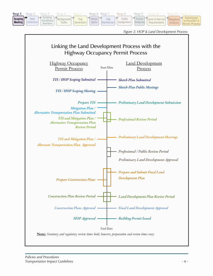
Figure 2 illustrates the relationship between the HOP process and the land development process.
The goal is to insure that the land development approval and HOP approval are timely and consistent with the development review times specified in the Municipalities Planning Code.
In addition, the Department recommends that applicants submit a TIS to the Department simultaneous with the submission of the same TIS to the municipality.
Policies and Procedures Transportation Impact Guidelines - 6 -
Figure 2: HOP & Land Development Process
Policies and Procedures Transportation Impact Guidelines - 7 -
Scoping Meeting
All applicants are required to initiate the process of scheduling a scoping meeting through the District Permit Manager with the appropriate District Office. To determine if a meeting is appropriate, the applicant must submit a completed Scoping Meeting Application (see Appendix B) to the Department and copy the municipality on the correspondence. After review of the scoping meeting application, the Department will promptly notify the applicant if a scoping meeting is required.
It is the applicant’s responsibility to invite the developer, their engineer, municipal representatives, as well as other agencies such as local transit authorities, MPOs or RPOs within the proposed study area limits to the scoping meeting, and obtain all information required at the meeting.
The applicant is required to notify the Department if they intend to bring legal counsel to the scoping meeting so that the Department may have appropriate legal representation. If the applicant has legal counsel in attendance at the meeting and has not provided the Department advance notification, the meeting may be rescheduled or cancelled.
The applicant is responsible for developing meeting minutes and distributing them to attendees within 7 business days of the meeting.
The District HOP Manager will be responsible for inviting the appropriate District personnel (i.e. Traffic Unit, Design Unit, Bridge Unit, Right-of-Way Unit, etc.) as well as Office of Chief Counsel, and/or FHWA or other
agencies depending on the scope of the project.
Preparation for the Scoping Meeting
Preparation should involve discussion with municipal officials as well as public transit providers regarding multi-modal transportation issues and the need to enhance the transportation network for the community. Permits for driveways will be evaluated on their ability to safely and efficiently function as an integral part of the highway system.
The ability of a driveway to safely and efficiently function as an integral component of a highway system requires that its design and construction be based on the amount and type of traffic that it is expected to serve and the type and character of roadway which it accesses.
The evaluation of the driveway will consider these elements.
Elements of the Scoping Meeting Agenda (see Appendix B) should be prepared in a concise format for meeting review purposes and all elements should be discussed at the meeting, as applicable.
Most items in the scoping meeting agenda should be familiar to transportation professionals or can be found in the ITE Recommended Practice for Traffic Access and Impact Studies for Site Development.
A five-mile radius map for regional overview and a local area map shall be prepared as well as preliminary trip generation/distribution information. The purpose of the five-mile radius map is to provide an overall regional perspective of the area. Within a one mile radius of the study area, any readily available
Policies and Procedures Transportation Impact Guidelines - 8 -
information such as volumes, intersection controls, or planned developments should be indicated on the map to assist in providing an overview of the roadway network of the area.
Study Area
Determining the extent of the study area is a critical task. It requires a working knowledge of the area of the development; the type and intensity of the development; an understanding of the current transportation conditions and functionality of the existing roadways in the vicinity of the development.
The limits of the site property under control of the developer and proposed site access locations shall be indicated on the map as well as the applicant’s proposed study intersections and roadways. This map shall be used to reach concurrence on the proposed study area scope. Guidance is provided in ITE, Transportation Impact Analysis for Site Development, Chapter 2 on the selection of study intersections. The applicant shall prepare a list of intersections proposed for study prior to the meeting.
Approval of Analysis Years/Growth Rates
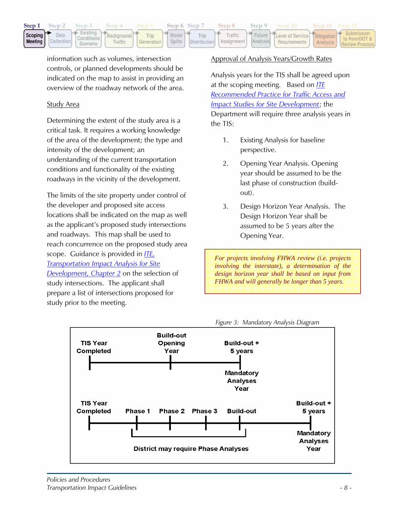
Analysis years for the TIS shall be agreed upon at the scoping meeting. Based on ITE Recommended Practice for Traffic Access and Impact Studies for Site Development; the Department will require three analysis years in the TIS:
1. Existing Analysis for baseline perspective.
2. Opening Year Analysis. Opening year should be assumed to be the last phase of construction (build-out).
3. Design Horizon Year Analysis. The Design Horizon Year shall be assumed to be 5 years after the Opening Year.
For projects involving FHWA review (i.e. projects involving the interstate), a determination of the design horizon year shall be based on input from FHWA and will generally be longer than 5 years.
Figure 3: Mandatory Analysis Diagram
Policies and Procedures Transportation Impact Guidelines - 9 -
Land use context, roadway classification and desired operating speed shall be evaluated by the applicant. However the Department, with input from the municipality, shall make the final determination of land use context, roadway classification and desired operating speed.
Projects involving multi-phased development may require additional analysis, and the analysis of opening years after each major phase should be considered (Figure 3).
The objective for additional analysis is to provide a clear view of transportation system operations, given the characteristics of the future development of the site and study area.
Growth factor assumptions shall be agreed upon at the scoping meeting. The background growth factor should be obtained from any of the following three sources:
1. The Department District Permit Office (to be generated from the Department’s Bureau of Planning and Research).
2. The Metropolitan Planning Organization (MPO) or the Rural Planning Organization (RPO) covering the study area, or
3. Other Department approved method.
Growth factors obtained from the Department shall be applied as an annually compounded growth rate to reflect the proposed traffic conditions at Opening Year and the Design Horizon Year. Growth factors obtained from MPO or RPO’s shall be applied in a compounded or linear fashion as directed by the MPO or RPO and concurred by the Department.
Land Use Context
The applicant must evaluate the existing “land use context(s)” of the study area surrounding the subject property, and whether the proposed land use will alter the land use context. The Department will approve the land use context at the Scoping Meeting. Land use context is important in determining the ideal roadway design. It provides guidance on aspects such as roadway design, travel lane width, on-street parking, and on the types of landscaping and lighting provided. It also plays a role in suggesting the desired operating speed.
As defined in the Smart Transportation Guidebook: Planning and Designing Highways and Streets that Support Sustainable and Livable Communities (Smart Transportation Guidebook), land use context is a unique combination of different land uses, building density, and other features. There are seven different land use contexts, in order of intensity: rural, suburban neighborhood, suburban corridor, suburban center, town/village neighborhood, town center, and urban core. For more information on land use context, see Chapter 4 of the Smart Transportation Guidebook.
Policies and Procedures Transportation Impact Guidelines - 10 -
Roadway Classification
The applicant must document and provide data for determination of the “functional classification” and “type” of all roadways adjacent to the subject property in the TIS. The Department will approve this information at the Scoping Meeting.
The functional classification – principal arterial, minor arterial, major collector, minor collector, local - can typically be determined by checking the Department’s Functional Class Maps. These maps identify the functional classification for all state roadways and occasionally important local or county owned roadways.
As defined in the Smart Transportation Guidebook, the “roadway type” is an overlay on the conventional functional classification system, which describes the role played by the roadway within the larger community. In the case of an arterial, is the roadway more important in accommodating regional traffic movements, or in accommodating motorists on trips to businesses, schools or other destinations in the area? If the former, the roadway type might be a “regional arterial”; if the latter, it might be a “community arterial.” Typical running speed on the roadway, intensity of access points, and knowledge of travel patterns on the roadway (use of the roadway by motorists conducting regional trips) should all be evaluated when determining the roadway type. For more information on identifying roadway type, refer to Chapter 5 of the Smart Transportation Guidebook.
After documenting the existing roadway type, the applicant should evaluate whether any planned transportation projects, or major land use developments, have the potential to change the roadway type in the future.
Desired Operating Speed
The Smart Transportation Guidebook formally defines desired operating speed as the speed of traffic that best reflects the function of the roadway and the surrounding land use context; informally, it is the speed at which we would like vehicles to travel. The Department will evaluate the desired operating speed on state roadways adjacent to the development if requested by municipal officials. All such requests should indicate the proposed desired operating speed, refer to the existing operating speeds and crash history, and describe the benefits to existing and projected roadway users from the proposed desired operating speed. The applicant may be requested by the Department to provide data for this evaluation and the municipality may be required to address any changes to the regulatory posted speed. The Department will make the final determination on desired operating speed and posted speed for all state roadways.
It should be noted that for purposes of determining sight distance at proposed driveways, existing roadway conditions/speeds should be utilized in accordance with 67 PA Code Section 441.8(h).
Policies and Procedures Transportation Impact Guidelines - 11 -
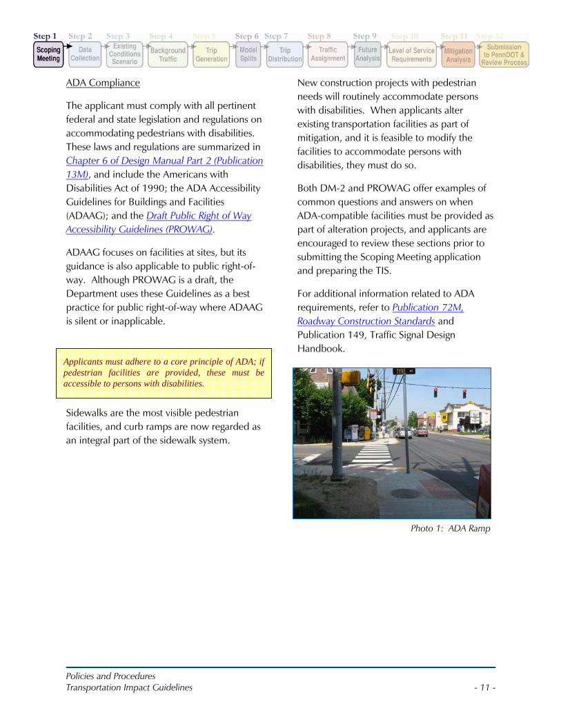
Applicants must adhere to a core principle of ADA; if pedestrian facilities are provided, these must be accessible to persons with disabilities.
Photo 1: ADA Ramp
ADA Compliance
The applicant must comply with all pertinent federal and state legislation and regulations on accommodating pedestrians with disabilities. These laws and regulations are summarized in Chapter 6 of Design Manual Part 2 (Publication 13M), and include the Americans with Disabilities Act of 1990; the ADA Accessibility Guidelines for Buildings and Facilities (ADAAG); and the Draft Public Right of Way Accessibility Guidelines (PROWAG).
ADAAG focuses on facilities at sites, but its guidance is also applicable to public right-of-way. Although PROWAG is a draft, the Department uses these Guidelines as a best practice for public right-of-way where ADAAG is silent or inapplicable.
Sidewalks are the most visible pedestrian facilities, and curb ramps are now regarded as an integral part of the sidewalk system.
New construction projects with pedestrian needs will routinely accommodate persons with disabilities. When applicants alter existing transportation facilities as part of mitigation, and it is feasible to modify the facilities to accommodate persons with disabilities, they must do so.
Both DM-2 and PROWAG offer examples of common questions and answers on when ADA-compatible facilities must be provided as part of alteration projects, and applicants are encouraged to review these sections prior to submitting the Scoping Meeting application and preparing the TIS.
For additional information related to ADA requirements, refer to Publication 72M, Roadway Construction Standards and Publication 149, Traffic Signal Design Handbook.
Policies and Procedures Transportation Impact Guidelines - 12 -
STEP 2: DATA COLLECTIONPreparation of the Transportation Impact Study (TIS) will involve data collection, which is the sole responsibility of the applicant. Review of previous studies and inclusion of data gathered for other studies may be acceptable to the Department provided:
• The data is not greater than 3 years old when the TIS is submitted to the Department and
• Traffic volumes or patterns have not significantly changed.
Volume Counts/Data
Traffic volumes shall be obtained through data collection efforts at locations and times agreed upon during the scoping meeting.
It is required that new data obtained from 24-hour automatic traffic recorder counts include classification and speed data unless modified at the scoping meeting.
New data obtained from turning movement counts shall incorporate heavy vehicles, pedestrian and bicycle data. Transit vehicles shall also be reflected in traffic counts if present. Walking school children and school bus stops shall also be noted.
Based on the turning movement volumes, peak hour factors should be calculated by movement and used for analyses. As directed by the District at the scoping meeting, traffic volumes along corridors should be balanced between intersections when appropriate.
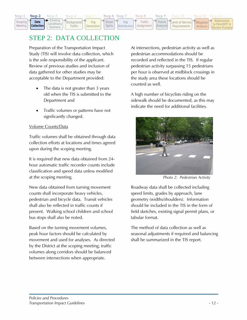
At intersections, pedestrian activity as well as pedestrian accommodations should be recorded and reflected in the TIS. If regular pedestrian activity surpassing 15 pedestrians per hour is observed at midblock crossings in the study area these locations should be counted as well.
A high number of bicyclists riding on the sidewalk should be documented, as this may indicate the need for additional facilities.
Roadway data shall be collected including speed limits, grades by approach, lane geometry (widths/shoulders). Information should be included in the TIS in the form of field sketches, existing signal permit plans, or tabular format.
The method of data collection as well as seasonal adjustments if required and balancing shall be summarized in the TIS report.
Photo 2: Pedestrian Activity
Policies and Procedures Transportation Impact Guidelines - 13 -
As noted in the Guidebook, certain areas may have characteristics common to more than one land use context, and other areas will be hard to identify. The applicant should identify the land use context that seems most representative of a roadway segment as whole. Land use contexts should not be defined in too fine a manner; avoid segments of less than 600-feet in length.
Land Use Context
As discussed in Step 1, Scoping Meeting, the applicant must document the land use context of the subject property, and along key area roadways.
Using the written description of land use contexts in the Smart Transportation Guidebook, the applicant should first conduct a “windshield screen” field view along roadways in the study area, and identify the different land use contexts present prior to the Scoping Meeting. If the land use context is not obvious from initial field views, the applicant can use aerial photographs and municipal zoning ordinances and use the quantitative description presented in Figure 4.3 of the Guidebook to identify the land use context.
Sight Distance and Site Access
Adequate sight distance at existing and proposed intersections and driveways is critical to safe traffic operations within the study area. The applicant shall conduct sight distance measurements at locations agreed upon during the Scoping Meeting.
Desirable sight distance, safe stopping distance, and existing/measured sight distance at the access locations shall be provided in the TIS as outlined in 67 PA Code Section 441.8(h). Sight distance shall be obtained and measured in accordance with Highway
Occupancy Permit Guidelines PENNDOT Publication 282.
Applicants should utilize form M-950S, available through the District Permit Office, which provides uniform methods for measuring and documenting actual driveway Formula Sight Distance measurements.
Photographs
Photographs should be obtained at all study intersections and proposed access driveways and labeled appropriately. It is recommended that two views be taken of each approach for intersections:
1. Approximately 200-feet from the intersection to provide an overview of the approach including pavement markings, shoulders, trees, and overall study area context and
2. Approximately 50-feet from the intersection and show the opposite approach.
Photographs should take into consideration elements such as horizontal/vertical alignment of roadways, trees, buildings or other roadside objects, pavement markings, drainage, signal heads & placement. Color photos reproduced at a 4”x6” size are recommended.
Crash Data
Crash data for the study area shall be obtained as agreed upon at the scoping meeting. The most recent five years of crash data for each approach route should be obtained. The applicant shall analyze the crash data to determine if there are any crash patterns within the study area. The applicant should also contact the municipality for input regarding non-reportable crashes. Analysis of
Policies and Procedures Transportation Impact Guidelines - 14 -
the crash data should include review of causation factors and patterns. The Depart-ment will provide:
• a Crash Summary Report, • a Crash Resume Report, • a Crash grouped by Segment Report,
and • the current Statewide Homogeneous
Report.
To request this information, contact the District Safety Engineer within the appropriate District Traffic Unit. Include the analysis of the crash data in the Appendix. Exclude the copies of the crash reports. Additional information on the analysis of crash rates can be found in the Appendix of Publication 212, Item 2(1) and Publication 46, Chapter 11.3.2.
Pedestrian/ Bike/ Transit Facilities
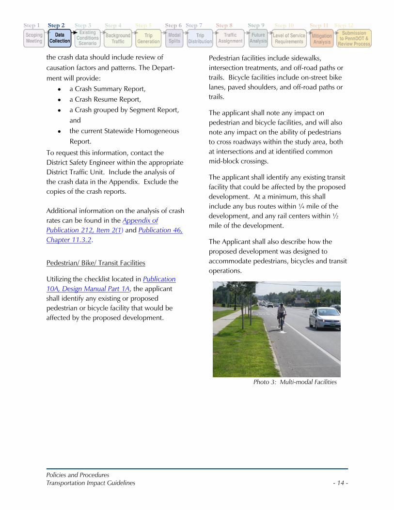
Utilizing the checklist located in Publication 10A, Design Manual Part 1A, the applicant shall identify any existing or proposed pedestrian or bicycle facility that would be affected by the proposed development.
Pedestrian facilities include sidewalks, intersection treatments, and off-road paths or trails. Bicycle facilities include on-street bike lanes, paved shoulders, and off-road paths or trails.
The applicant shall note any impact on pedestrian and bicycle facilities, and will also note any impact on the ability of pedestrians to cross roadways within the study area, both at intersections and at identified common mid-block crossings.
The applicant shall identify any existing transit facility that could be affected by the proposed development. At a minimum, this shall include any bus routes within ¼ mile of the development, and any rail centers within ½ mile of the development.
The Applicant shall also describe how the proposed development was designed to accommodate pedestrians, bicycles and transit operations.
Photo 3: Multi-modal Facilities
Policies and Procedures Transportation Impact Guidelines - 15 -
STEP 3: EXISTING CONDITIONS SCENARIOThe applicant shall document existing transportation conditions within the study area, including but not limited to volumes, capacity and level of service analysis, and crash analysis. In addition, the existing conditions shall discuss multimodal transportation such as bicycles, pedestrians and transit and describe existing facilities or lack thereof. If pedestrian facilities are provided, a discussion of ADA compliance is appropriate.
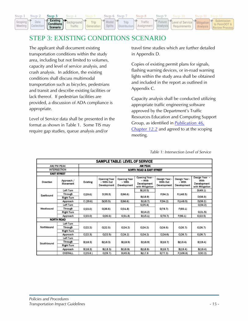
Level of Service data shall be presented in the format as shown in Table 1. Some TIS may require gap studies, queue analysis and/or
travel time studies which are further detailed in Appendix D.
Copies of existing permit plans for signals, flashing warning devices, or in-road warning lights within the study area shall be obtained and included in the report as outlined in Appendix C.
Capacity analysis shall be conducted utilizing appropriate traffic engineering software approved by the Department’s Traffic Resources Education and Computing Support Group, as identified in Publication 46, Chapter 12.2 and agreed to at the scoping meeting.
Table 1: Intersection Level of Service
Policies and Procedures Transportation Impact Guidelines - 16 -
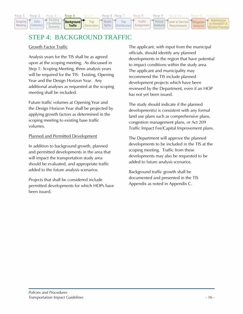
STEP 4: BACKGROUND TRAFFICGrowth Factor Traffic
Analysis years for the TIS shall be as agreed upon at the scoping meeting. As discussed in Step 1: Scoping Meeting, three analysis years will be required for the TIS: Existing, Opening Year and the Design Horizon Year. Any additional analyses as requested at the scoping meeting shall be included.
Future traffic volumes at Opening Year and the Design Horizon Year shall be projected by applying growth factors as determined in the scoping meeting to existing base traffic volumes.
Planned and Permitted Development
In addition to background growth, planned and permitted developments in the area that will impact the transportation study area should be evaluated, and appropriate traffic added to the future analysis scenarios.
Projects that shall be considered include permitted developments for which HOPs have been issued.
The applicant, with input from the municipal officials, should identify any planned developments in the region that have potential to impact conditions within the study area. The applicant and municipality may recommend the TIS include planned development projects which have been reviewed by the Department, even if an HOP has not yet been issued.
The study should indicate if the planned development(s) is consistent with any formal land use plans such as comprehensive plans, congestion management plans, or Act 209 Traffic Impact Fee/Capital Improvement plans.
The Department will approve the planned developments to be included in the TIS at the scoping meeting. Traffic from these developments may also be requested to be added to future analysis scenarios.
Background traffic growth shall be documented and presented in the TIS Appendix as noted in Appendix C.
Policies and Procedures Transportation Impact Guidelines - 17 -
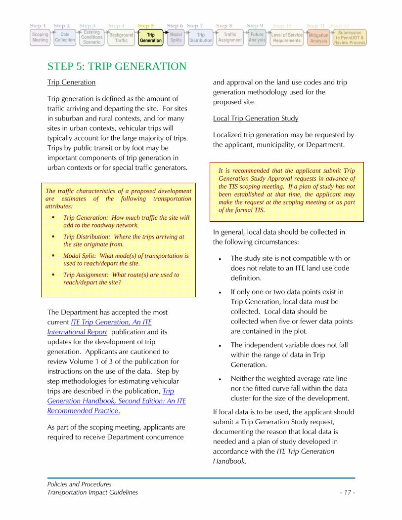
The traffic characteristics of a proposed development are estimates of the following transportation attributes:
Trip Generation: How much traffic the site will add to the roadway network.
Trip Distribution: Where the trips arriving at the site originate from.
Modal Split: What mode(s) of transportation is used to reach/depart the site.
Trip Assignment: What route(s) are used to reach/depart the site?
It is recommended that the applicant submit Trip Generation Study Approval requests in advance of the TIS scoping meeting. If a plan of study has not been established at that time, the applicant may make the request at the scoping meeting or as part of the formal TIS.
STEP 5: TRIP GENERATIONTrip Generation
Trip generation is defined as the amount of traffic arriving and departing the site. For sites in suburban and rural contexts, and for many sites in urban contexts, vehicular trips will typically account for the large majority of trips. Trips by public transit or by foot may be important components of trip generation in urban contexts or for special traffic generators.
The Department has accepted the most current ITE Trip Generation, An ITE International Report publication and its updates for the development of trip generation. Applicants are cautioned to review Volume 1 of 3 of the publication for instructions on the use of the data. Step by step methodologies for estimating vehicular trips are described in the publication, Trip Generation Handbook, Second Edition: An ITE Recommended Practice.
As part of the scoping meeting, applicants are required to receive Department concurrence
and approval on the land use codes and trip generation methodology used for the proposed site.
Local Trip Generation Study
Localized trip generation may be requested by the applicant, municipality, or Department.
In general, local data should be collected in the following circumstances:
• The study site is not compatible with or does not relate to an ITE land use code definition.
• If only one or two data points exist in Trip Generation, local data must be collected. Local data should be collected when five or fewer data points are contained in the plot.
• The independent variable does not fall within the range of data in Trip Generation.
• Neither the weighted average rate line nor the fitted curve fall within the data cluster for the size of the development.
If local data is to be used, the applicant should submit a Trip Generation Study request, documenting the reason that local data is needed and a plan of study developed in accordance with the ITE Trip Generation Handbook.
Policies and Procedures Transportation Impact Guidelines - 18 -
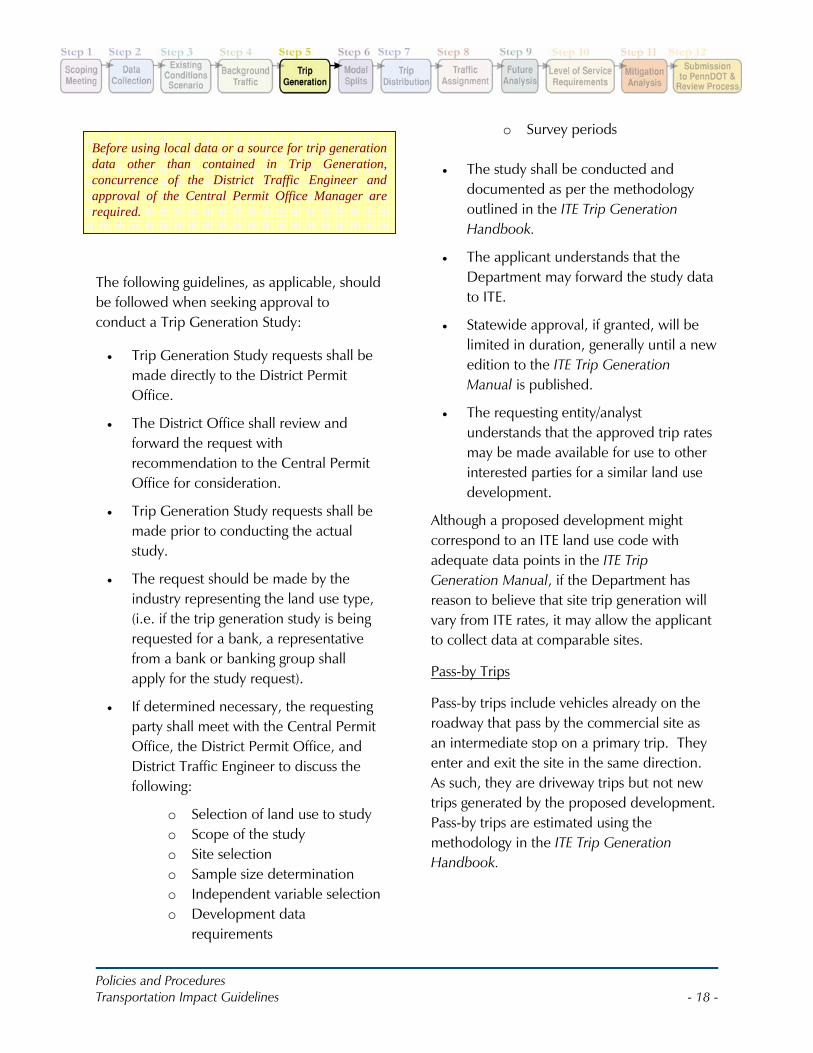
Before using local data or a source for trip generation data other than contained in Trip Generation, concurrence of the District Traffic Engineer and approval of the Central Permit Office Manager are required.
The following guidelines, as applicable, should be followed when seeking approval to conduct a Trip Generation Study:
• Trip Generation Study requests shall be made directly to the District Permit Office.
• The District Office shall review and forward the request with recommendation to the Central Permit Office for consideration.
• Trip Generation Study requests shall be made prior to conducting the actual study.
• The request should be made by the industry representing the land use type, (i.e. if the trip generation study is being requested for a bank, a representative from a bank or banking group shall apply for the study request).
• If determined necessary, the requesting party shall meet with the Central Permit Office, the District Permit Office, and District Traffic Engineer to discuss the following:
o Selection of land use to study o Scope of the study o Site selection o Sample size determination o Independent variable selection o Development data
requirements
o Survey periods
• The study shall be conducted and documented as per the methodology outlined in the ITE Trip Generation Handbook.
• The applicant understands that the Department may forward the study data to ITE.
• Statewide approval, if granted, will be limited in duration, generally until a new edition to the ITE Trip Generation Manual is published.
• The requesting entity/analyst understands that the approved trip rates may be made available for use to other interested parties for a similar land use development.
Although a proposed development might correspond to an ITE land use code with adequate data points in the ITE Trip Generation Manual, if the Department has reason to believe that site trip generation will vary from ITE rates, it may allow the applicant to collect data at comparable sites.
Pass-by Trips
Pass-by trips include vehicles already on the roadway that pass by the commercial site as an intermediate stop on a primary trip. They enter and exit the site in the same direction. As such, they are driveway trips but not new trips generated by the proposed development. Pass-by trips are estimated using the methodology in the ITE Trip Generation Handbook.
Policies and Procedures Transportation Impact Guidelines - 19 -
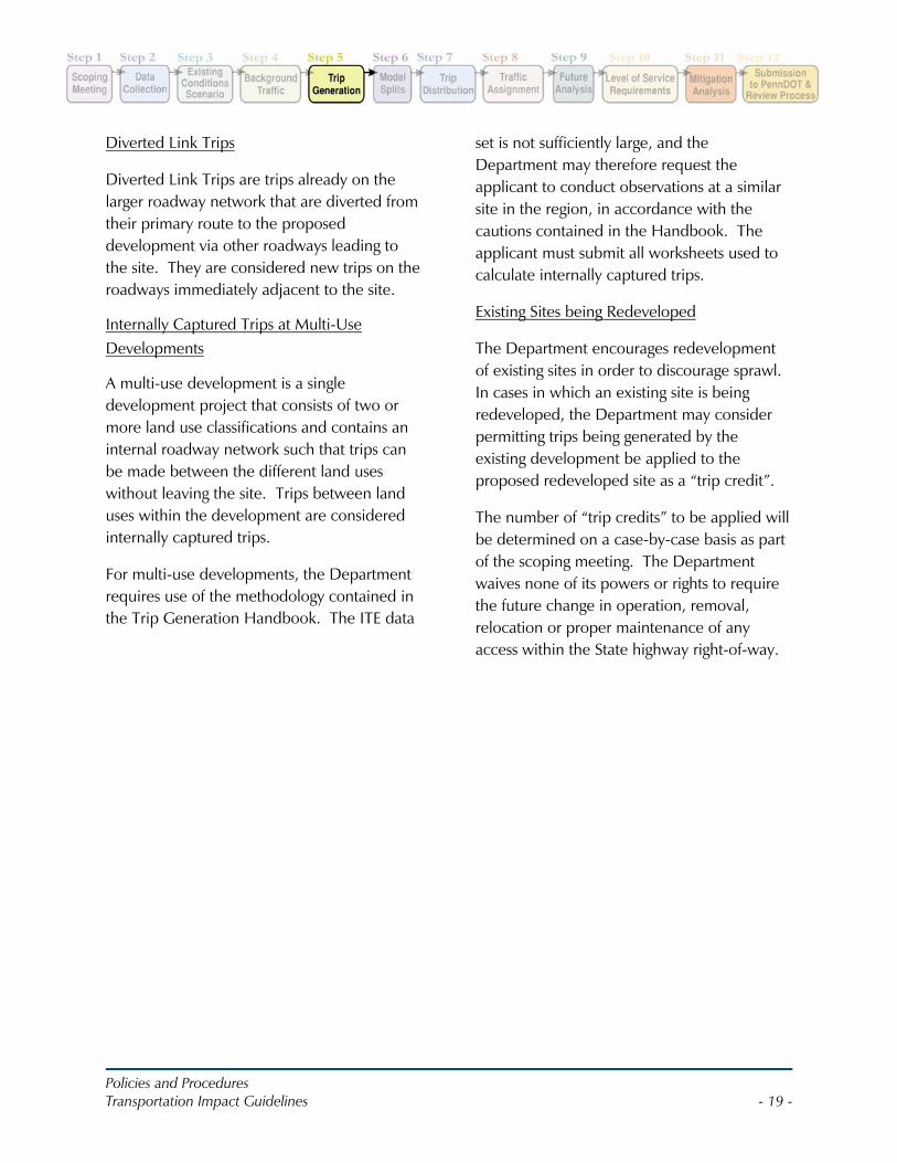
Diverted Link Trips
Diverted Link Trips are trips already on the larger roadway network that are diverted from their primary route to the proposed development via other roadways leading to the site. They are considered new trips on the roadways immediately adjacent to the site.
Internally Captured Trips at Multi-Use Developments
A multi-use development is a single development project that consists of two or more land use classifications and contains an internal roadway network such that trips can be made between the different land uses without leaving the site. Trips between land uses within the development are considered internally captured trips.
For multi-use developments, the Department requires use of the methodology contained in the Trip Generation Handbook. The ITE data
set is not sufficiently large, and the Department may therefore request the applicant to conduct observations at a similar site in the region, in accordance with the cautions contained in the Handbook. The applicant must submit all worksheets used to calculate internally captured trips.
Existing Sites being Redeveloped
The Department encourages redevelopment of existing sites in order to discourage sprawl. In cases in which an existing site is being redeveloped, the Department may consider permitting trips being generated by the existing development be applied to the proposed redeveloped site as a “trip credit”.
The number of “trip credits” to be applied will be determined on a case-by-case basis as part of the scoping meeting. The Department waives none of its powers or rights to require the future change in operation, removal, relocation or proper maintenance of any access within the State highway right-of-way.
Policies and Procedures Transportation Impact Guidelines - 20 -
If applicants can provide documentation indicating that the percentage of trips conducted via alternative modes will be even greater than shown below, such documentation may be considered by Department. Cities such as Pittsburgh and Philadelphia have transit studies that may be used and considered by the Department. Applicants shall discuss the use of modal splits during the Scoping Meeting and obtain concurrence from the Department.
STEP 6: MODAL SPLITSStandard Assumptions for Alternative Trips
This section recognizes the potential for non-vehicular trips and offers “standard assumptions” for the modal split of alternative trips provided that pedestrian, bike, and transit-friendly characteristics are present. It covers two land uses: residential and business.
Although it is easier to estimate trips conducted by automobile than by alternative modes, progress has been made on methods to calculate the potential for alternative trip modes.
Studies have documented the factors that account for the difference in alternative mode trips that can exist between similar land uses, if designed differently and placed in a different environment.
Factors that lend themselves to a greater number of non-vehicular trips include presence of pedestrian, bike, and transit facilities; high density; mix of land uses in close proximity; good roadway connectivity; promotion of alternative trips (through work trip demand management programs); price of parking; and other factors.
Trip reductions have been identified for developments within ½ mile of bus routes in the following section. Studies have shown a wide range of trip reductions for developments within ½ mile of rail and subway stations and trip reductions; therefore standard trip reductions are not identified in this section for those types of transit facilities.
For such developments applicants should use the transit studies provided by the appropriate transit agency and/or Census data for existing development near the transit facilities.
These standard assumptions may not be used when the source of trip generation data is a count at a comparable local site. Notwithstanding the percentages below, the total number of non-vehicular trips assumed by the applicant shall not exceed 500 vehicle trips per peak hour of the generator unless approved by the Department.
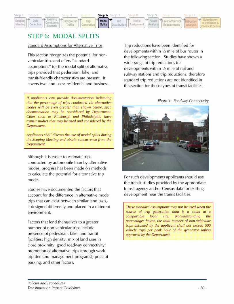
Photo 4: Roadway Connectivity
Policies and Procedures Transportation Impact Guidelines - 21 -
Residential Land Use
1. Residential Pedestrian accommodations – up to 4% of trips.
Where pedestrian facilities (i.e. sidewalks, crosswalks etc.) cover at least 95% of the roadway network, including 95% of arterials and collectors within ½ mile of the land use, pedestrian trips may account for 4% of all trips. Where pedestrian facilities cover 91% to 95% of the roadway network, including 91% to 95% of arterials and collectors, within ½ mile of the land use, pedestrian trips may account for 3% of all trips.
Where pedestrian facilities cover 80% to 90% of the roadway network, including 80% to 90% of arterials and collectors, within ½ mile of the land use, pedestrian trips may account for 2% of trips. These assumptions may only be used if:
• The roadway connectivity index as described in the Smart Transportation Guidebook is within the ½ mile radius is equal to or higher than 1.4 (roadway connectivity is the number of street links divided by nodes or street ends); and
• There are at least two of the following six major land use classifications, as defined in ITE Trip Generation, within the ½ mile radius: residential, institutional (schools and colleges only), medical, office, retail, services (banks and restaurants only); and
• The development has a gross density of at least three housing units per acre.
The “roadway network” refers only to the portion of the roadway network within the ½ mile radius that is adjacent to developed land uses.
2. Residential bicycle accommodations – up to 1% of trips.
For the purposes of this subsection, a bicycle accommodation is defined as a street with a design speed of 25 MPH or less that carries 3,000 vehicles per day or less; on-street bike lanes; paved shoulders of roadways that are at least four feet wide; or exclusive and shared off-street bicycle paths.
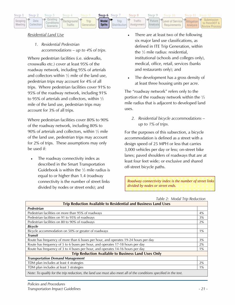
Table 2: Modal Trip Reduction Trip Reduction Available to Residential and Business Land Uses
Pedestrian Pedestrian facilities on more than 95% of roadways 4% Pedestrian facilities on 91 to 95% of roadways 3% Pedestrian facilities on 80 to 90% of roadways 2% Bicycle Bicycle accommodation on 50% or greater of roadways 1% Transit Route has frequency of more than 6 buses per hour, and operates 19-24 hours per day 3% Route has frequency of 5 to 6 buses per hour, and operates 17-18 hours per day 2% Route has frequency of 3 to 4 buses per hour, and operates 14-16 hours per day 1%
Trip Reduction Available to Business Land Uses Only Transportation Demand Management TDM plan includes at least 4 strategies 2% TDM plan includes at least 3 strategies 1%
Note: To qualify for the trip reduction, the land use must also meet all of the conditions specified in the text.
Roadway connectivity index is the number of street links divided by nodes or street ends.
Policies and Procedures Transportation Impact Guidelines - 22 -
Where at least 50% of the roadway network within ½ mile of the development, including 50% of arterial and collector roadways, offers bicycle accommodation, bicycle trips may account for 1.0% of all trips. This assumption may only be used if:
• The connectivity index within the ½ mile radius is equal to or higher than 1.4 and
• There are at least two of the following six major land use classifications, as defined in ITE Trip Generation, within the ½ mile radius: residential, institutional (schools and colleges only), medical, office, retail, services (banks and restaurants only); and
• The development has a gross density of at least three housing units per acre.
The “roadway network” refers only to the portion of the roadway network within the ½ mile radius that is adjacent to developed land uses.
3. Residential bus accommodations – up to 3% of trips.
Bus accommodation is defined as a bus route within ¼ mile of the development. Where the service frequency of bus lines serving the bus stop is at more than six buses per hour, and where the line operates at least 19-24 hours per day, transit trips may account for 3.0% of all trips.
Where the service frequency of bus lines serving the bus stop is at least five to six buses per hour, and where the line operates at least 17-18 hours per day, transit trips may account for 2.0% of all trips.
Where the service frequency of bus lines serving the bus stop is at least three to four
buses per hour, and where the line operates at least 14-16 hours per day, transit trips may account for 1.0% of all trips. These assumptions shall be taken only if over 90% of the primary routes between the development and the bus stop have sidewalks.
Business Land Use
1. Business pedestrian accommodations – up to 4% of trips.
Where pedestrian facilities cover at least 95% of the roadway network, including 95% of arterials and collectors within ½ mile of the land use, pedestrian trips may account for 4% of all trips.
Where pedestrian facilities cover 91% to 95% of the roadway network, including 91% to 95% of arterials and collectors, within ½ mile of the land use, pedestrian trips may account for 3% of all trips.
Where pedestrian facilities cover 80% to 90% of the roadway network, including 80% to 90% of arterials and collectors, within ½ mile of the land use, pedestrian trips may account for 2% of trips. These assumptions may only be used if:
• The roadway connectivity index, within the ½ mile radius is equal to or higher than 1.4; and
• There are at least two of the following six major land use classifications, as defined in ITE Trip Generation, within the ½ mile radius: residential, institutional (schools and colleges only), medical, office, retail, services (banks and restaurants only).
Policies and Procedures Transportation Impact Guidelines - 23 -
The “roadway network” refers to the portion of the roadway network within the ½ mile radius that is adjacent to developed land uses.
2. Business bicycle accommodations – up to 3% of trips.
For the purposes of this subsection, a bicycle accommodation is defined as a street with a design speed of 25 MPH or less that carries 3,000 vehicles per day or less; on-street bike lanes; paved shoulders of roadways that are at least four feet wide; or exclusive and shared off-street bicycle paths.
Where at least 50% of the roadway network within ½ mile of the development, including 50% of arterial and collector roadways, offers bicycle accommodation, bicycle trips may account for 1.0% of all trips.
This assumption may only be used if:
• The connectivity index within the ½ mile radius is equal to or higher than 1.4 (roadway connectivity is the number of street links divided by nodes or street ends); and
• There are at least two of the following five major land use classifications, as defined in ITE Trip Generation, within
the ½ mile radius: residential, institutional (schools and colleges only), medical, office, retail, services (banks and restaurants only); and
• Bike rack is provided at or within 200 feet of the business.
The “roadway network” refers only to the portion of the roadway network within the ½ mile radius that is adjacent to developed land uses.
3. Business bus accommodations – up to 3% of trips.
Bus accommodation is defined as a bus route within ¼ mile of the development. Where the service frequency of bus lines serving the bus stop is at more than six buses per hour, and where the line operates at least 19-24 hours per day, transit trips may account for 3.0% of all trips.
Where the service frequency of bus lines serving the bus stop is at least five to six buses per hour, and where the line operates at least 17-18 hours per day, transit trips may account for 2.0% of all trips.
Where the service frequency of bus lines serving the bus stop is at least three to four buses per hour, and where the line operates at least 14-16 hours per day, transit trips may account for 1.0% of all trips. These assumptions shall be taken only if over 90% of the primary routes between the development and the bus stop have sidewalks.
4. Business Transportation Demand Management – up to 2% of trips.
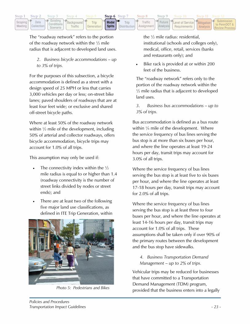
Vehicular trips may be reduced for businesses that have committed to a Transportation Demand Management (TDM) program, provided that the business enters into a legally Photo 5: Pedestrians and Bikes
Policies and Procedures Transportation Impact Guidelines - 24 -
enforceable agreement, such as a developers’ agreement with the local municipality, with a guarantee that the mitigation measures will be implemented. The credit for the TDM program depends upon the number of TDM strategies that the business is willing to implement.
The options are:
• Parking pricing (employees must pay share of parking expense)
• Telecommuting
• Compressed/ Flexible Work Schedule
• Guaranteed Ride Home
• Locker and showers, and place to store bikes
• Car-sharing or car-matching services
• Free transit pass
The business may reduce trips by 2.0% if at least four of the elements listed above are part of the TDM program, and may reduce trips by 1.0% if three elements are part of the TDM program.
Policies and Procedures Transportation Impact Guidelines - 25 -
STEP 7: TRIP DISTRIBUTIONEstimating the arrival and departure pattern of traffic to a site requires knowledge of:
• Transportation system (e.g., location of the major roadways, parking facilities and the traffic patterns of those roadways);
• Turning movement data at adjacent driveways or streets with similar traffic characteristics to the proposed site (e.g., if analyzing a proposed residential development, study the driveway of an adjacent residential development);
• Travel times in and around the proposed development; and
• Availability of public transportation and pedestrian accommodations.
For business land uses, applicants should analyze the place of residence for employees using employee zip code data.
For retail goods and services, applicants should consider the prospective market area (e.g. where the anticipated customers live).
Once the available data has been collected, the applicant should select the appropriate trip distribution model.
Justification for use of the trip distribution model should be provided in the TIS. In addition, all supporting assumptions and calculations shall be included in the TIS to ensure that the trip distribution calculations can be verified by the Department.
Figures for trip distribution shall be provided as outlined in the Appendix C.
The Department typically prefers the following distribution models to be used with these certain land uses:
Residential – gravity model based upon place of employment (US Census data);
Commercial – gravity model based upon a market sector study prepared by a professional marketing firm retained by the developer;
Employment center – gravity model based upon place of residence (US Census data); and,
Existing institution (hospital, school) to be relocated or expanded – use existing employee zip code data for employees, and use US Census place of residence data for clients or students.
MPO/RPO or local municipal model
Policies and Procedures Transportation Impact Guidelines - 26 -
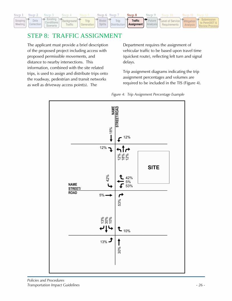
STEP 8: TRAFFIC ASSIGNMENTThe applicant must provide a brief description of the proposed project including access with proposed permissible movements, and distance to nearby intersections. This information, combined with the site related trips, is used to assign and distribute trips onto the roadway, pedestrian and transit networks as well as driveway access point(s). The
Department requires the assignment of vehicular traffic to be based upon travel time (quickest route), reflecting left turn and signal delays.
Trip assignment diagrams indicating the trip assignment percentages and volumes are required to be included in the TIS (Figure 4).
Figure 4: Trip Assignment Percentage Example
Policies and Procedures Transportation Impact Guidelines - 27 -
STEP 9: FUTURE ANALYSISFuture Year traffic volumes shall be generated for the study area, along with a spreadsheet clearly indicating the baseline traffic growth volumes and traffic generated by planned or approved projects in the study area. A traffic volume figure depicting the Future Year Volumes and roadway conditions shall be provided as indicated in the Appendix C.
Without Development Future Year
The applicant shall conduct an analysis of the Without Development Future Year scenarios. Without Development Future Year analyses shall be calculated using the same methodology as the Existing Conditions Scenario.
Analysis of the Without Development Future Year shall be conducted for two future time frames as agreed upon during the Scoping Meeting:
• Opening Year
• Design Horizon Year
Capacity and delay for the intersections in the study area shall be presented in the LOS Table format as indicated in Appendix C. Queue and turn lane analysis shall be conducted and
provided as appropriate (Refer to SOL 470-08-7, Turn Lane Guidelines which will be incorporated into Publication 46, Chapter 11 with the next update).
With Development Future Year
Analysis of the With Development Future Year shall be conducted for two future time frames as agreed upon during the Scoping Meeting:
• Opening Year
• Design Horizon Year
With Development Future Year analyses are required for peak travel periods for study area intersections and for a corridor or roadway analysis. Queue and turn lane analysis should also be conducted as required.
1. No Improvement Scenario analysis shall be conducted to determine the impacts of the proposed development. The capacity and delay results shall be included in the LOS Table indicated in Appendix C.
Concept plans of full mitigation shall be prepared with sufficient detail to describe their feasibility. Development of construction cost estimates is required along with noting any proposed design exception(s). The plans must also show right-of-way lines. Acceptable base plans are aerial photographs or as-built plans. The applicant may provide a plan on a new survey base if the applicant believes it is needed at this stage. The plan scale should be in 50-scale unless otherwise agreed to at the scoping meeting. Construction cost estimates shall be provided for the full mitigation scenario.
Analysis of traffic signals should assume optimized signal timing for the without development and with development conditions. In the event that existing uncoordinated signals are recommended for coordination that involves signals outside the study area, the external signals may need to be analyzed to ensure efficient operation of the entire system. This should be discussed with the District Traffic Engineer as appropriate.
Policies and Procedures Transportation Impact Guidelines - 28 -
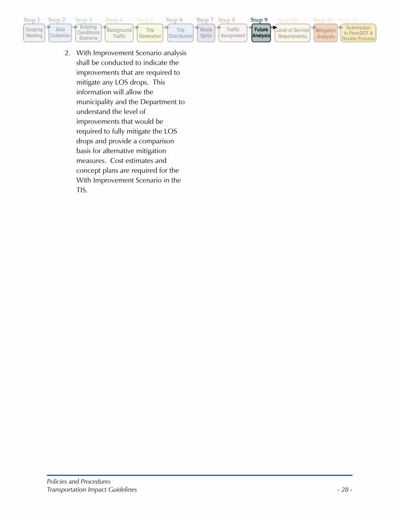
2. With Improvement Scenario analysis shall be conducted to indicate the improvements that are required to mitigate any LOS drops. This information will allow the municipality and the Department to understand the level of improvements that would be required to fully mitigate the LOS drops and provide a comparison basis for alternative mitigation measures. Cost estimates and concept plans are required for the With Improvement Scenario in the TIS.
Policies and Procedures Transportation Impact Guidelines - 29 -
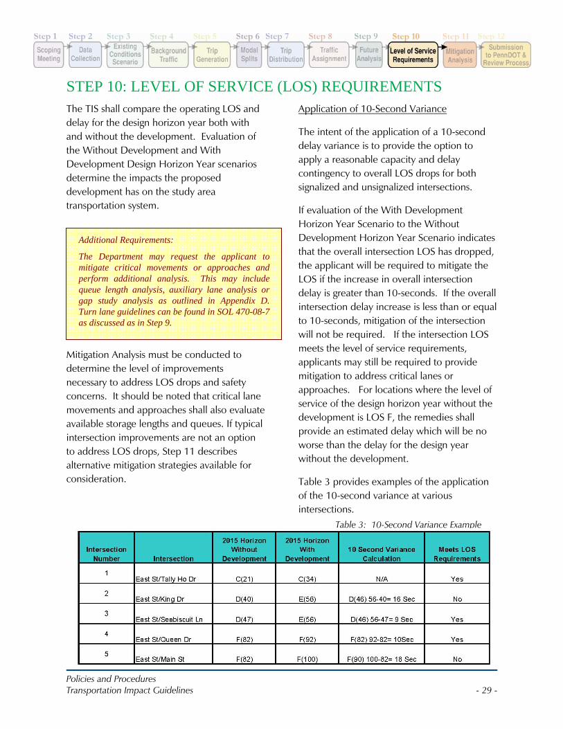
STEP 10: LEVEL OF SERVICE (LOS) REQUIREMENTSThe TIS shall compare the operating LOS and delay for the design horizon year both with and without the development. Evaluation of the Without Development and With Development Design Horizon Year scenarios determine the impacts the proposed development has on the study area transportation system.
Mitigation Analysis must be conducted to determine the level of improvements necessary to address LOS drops and safety concerns. It should be noted that critical lane movements and approaches shall also evaluate available storage lengths and queues. If typical intersection improvements are not an option to address LOS drops, Step 11 describes alternative mitigation strategies available for consideration.
Application of 10-Second Variance
The intent of the application of a 10-second delay variance is to provide the option to apply a reasonable capacity and delay contingency to overall LOS drops for both signalized and unsignalized intersections.
If evaluation of the With Development Horizon Year Scenario to the Without Development Horizon Year Scenario indicates that the overall intersection LOS has dropped, the applicant will be required to mitigate the LOS if the increase in overall intersection delay is greater than 10-seconds. If the overall intersection delay increase is less than or equal to 10-seconds, mitigation of the intersection will not be required. If the intersection LOS meets the level of service requirements, applicants may still be required to provide mitigation to address critical lanes or approaches. For locations where the level of service of the design horizon year without the development is LOS F, the remedies shall provide an estimated delay which will be no worse than the delay for the design year without the development.
Table 3 provides examples of the application of the 10-second variance at various intersections.
Additional Requirements:
The Department may request the applicant to mitigate critical movements or approaches and perform additional analysis. This may include queue length analysis, auxiliary lane analysis or gap study analysis as outlined in Appendix D. Turn lane guidelines can be found in SOL 470-08-7 as discussed as in Step 9.
Table 3: 10-Second Variance Example

Policies and Procedures Transportation Impact Guidelines - 30 -
As shown in Table 3, Intersection 1 indicates no LOS drop, therefore it meets the LOS Requirements.
Intersection 2 shows an overall intersection drop, but the delay difference is 16-seconds, which is greater than the 10-second variance. Therefore, Intersection 2 does not meet the overall intersection LOS requirements and mitigation is needed.
Intersection 3 indicates that the LOS has dropped, however the delay difference is 9-seconds which is less than the 10-second variance. Therefore, Intersection 3 meets the overall intersection LOS requirements.
Intersection 4 is already operating at LOS F, but the increase in delay is only 10-seconds in comparing the With Development Horizon Year to the Without Development scenario. Therefore, Intersection 4 meets the overall intersection LOS requirements.
Intersection 5 is also already operating at LOS F, but the increase in delay is 18-seconds in comparing the With Development Horizon Year to the Without Development scenario. Therefore, Intersection 5 does not meet the overall intersection LOS requirements because the delay exceeds the 10-second variance.
For mitigation scenarios, applicants are expected to mitigate the overall intersection LOS to the original Without Development LOS; the 10-second delay variance is not applied to mitigation scenarios. Applicants may be required to address available storage and queue lengths at critical movements or approaches even if the overall LOS requirements are met.
Queue analysis should consider the following:
• Are existing or projected turn lane lengths exceeded?
• Is queue spillback between adjacent intersections expected?
• Are proposed site driveways blocked by projected queues on highway network?
• Will queues into the site interfere with site circulation or result in spillback onto the public street network?
Following are LOS Requirements for the TIS:
Existing Signalized Intersections
With Development Horizon Year overall intersection LOS should be no worse than Without Development Horizon Year overall intersection LOS, except as noted previously.
Critical movements and approaches shall be evaluated and queues shall be evaluated to ensure that available storage exists for critical movements.
Existing Unsignalized Intersections
The evaluation of the performance of unsignalized/stop controlled intersections should include more than just the LOS and delay. Measures of effectiveness such as v/c ratios for individual movements and queue length shall be considered by applicants and presented in the TIS regardless of whether the following LOS requirements are met.
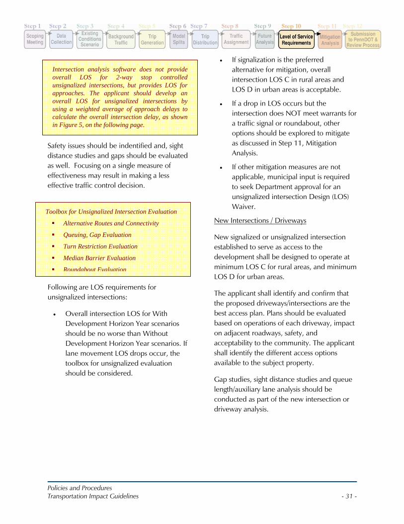
Policies and Procedures Transportation Impact Guidelines - 31 -
Safety issues should be indentified and, sight distance studies and gaps should be evaluated as well. Focusing on a single measure of effectiveness may result in making a less effective traffic control decision.
Following are LOS requirements for unsignalized intersections:
• Overall intersection LOS for With Development Horizon Year scenarios should be no worse than Without Development Horizon Year scenarios. If lane movement LOS drops occur, the toolbox for unsignalized evaluation should be considered.
• If signalization is the preferred alternative for mitigation, overall intersection LOS C in rural areas and LOS D in urban areas is acceptable.
• If a drop in LOS occurs but the intersection does NOT meet warrants for a traffic signal or roundabout, other options should be explored to mitigate as discussed in Step 11, Mitigation Analysis.
• If other mitigation measures are not applicable, municipal input is required to seek Department approval for an unsignalized intersection Design (LOS) Waiver.
New Intersections / Driveways
New signalized or unsignalized intersection established to serve as access to the development shall be designed to operate at minimum LOS C for rural areas, and minimum LOS D for urban areas.
The applicant shall identify and confirm that the proposed driveways/intersections are the best access plan. Plans should be evaluated based on operations of each driveway, impact on adjacent roadways, safety, and acceptability to the community. The applicant shall identify the different access options available to the subject property.
Gap studies, sight distance studies and queue length/auxiliary lane analysis should be conducted as part of the new intersection or driveway analysis.
Intersection analysis software does not provide overall LOS for 2-way stop controlled unsignalized intersections, but provides LOS for approaches. The applicant should develop an overall LOS for unsignalized intersections by using a weighted average of approach delays to calculate the overall intersection delay, as shown in Figure 5, on the following page.
Toolbox for Unsignalized Intersection Evaluation
Alternative Routes and Connectivity
Queuing, Gap Evaluation
Turn Restriction Evaluation
Median Barrier Evaluation
Roundabout Evaluation
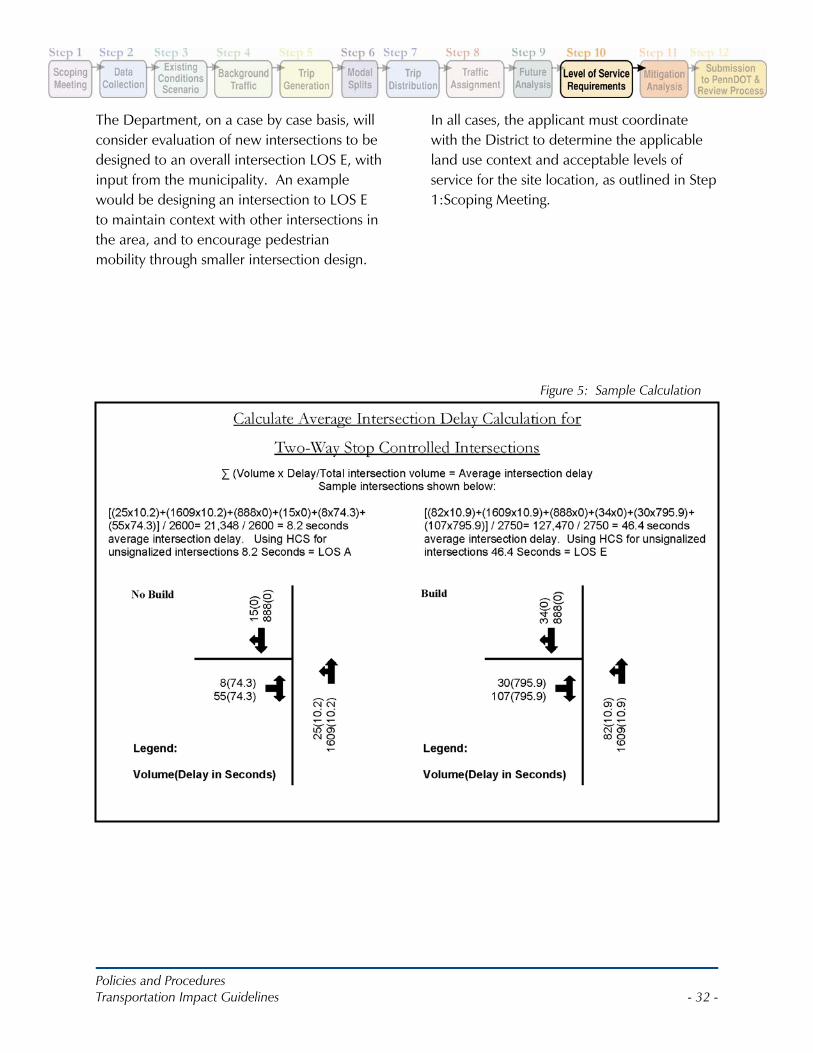
Policies and Procedures Transportation Impact Guidelines - 32 -
The Department, on a case by case basis, will consider evaluation of new intersections to be designed to an overall intersection LOS E, with input from the municipality. An example would be designing an intersection to LOS E to maintain context with other intersections in the area, and to encourage pedestrian mobility through smaller intersection design.
In all cases, the applicant must coordinate with the District to determine the applicable land use context and acceptable levels of service for the site location, as outlined in Step 1:Scoping Meeting.
Figure 5: Sample Calculation
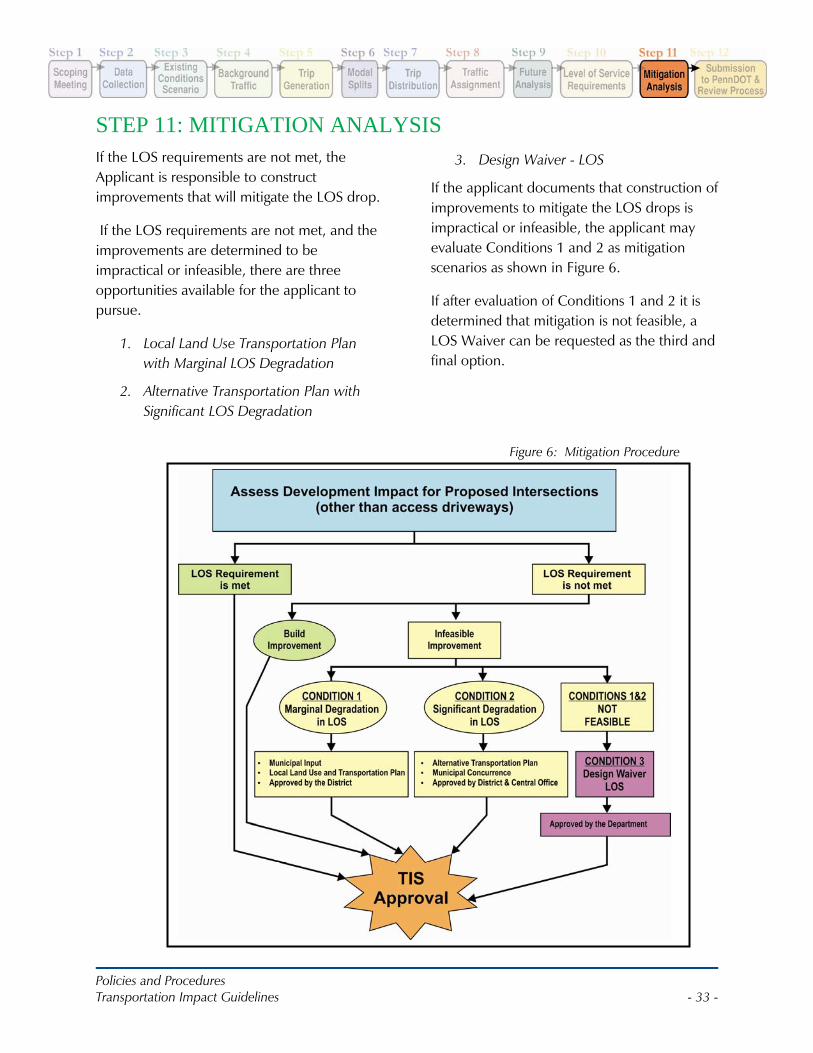
Policies and Procedures Transportation Impact Guidelines - 33 -
STEP 11: MITIGATION ANALYSISIf the LOS requirements are not met, the Applicant is responsible to construct improvements that will mitigate the LOS drop.
If the LOS requirements are not met, and the improvements are determined to be impractical or infeasible, there are three opportunities available for the applicant to pursue.
1. Local Land Use Transportation Plan with Marginal LOS Degradation
2. Alternative Transportation Plan with Significant LOS Degradation
3. Design Waiver - LOS
If the applicant documents that construction of improvements to mitigate the LOS drops is impractical or infeasible, the applicant may evaluate Conditions 1 and 2 as mitigation scenarios as shown in Figure 6.
If after evaluation of Conditions 1 and 2 it is determined that mitigation is not feasible, a LOS Waiver can be requested as the third and final option.
Figure 6: Mitigation Procedure
Policies and Procedures Transportation Impact Guidelines - 34 -
Condition 1: Marginal LOS Degradation, Local Land Use and Transportation Plan
If the LOS requirements are not met and improvements required to mitigate the impacts are impractical or infeasible, the applicant may evaluate the use of the Marginal LOS Degradation condition. Marginal Degradation is defined as overall intersection LOS within LOS range of LOS B to LOS C for rural areas, and LOS B to LOS D for urban areas.
The Department will consider accepting the Marginal LOS Degradation based on municipal input and review of the Municipal Land Use and Transportation Plan to ensure congestion and delay are managed in the study area. The Municipal Land Use and Transportation Plan and correspondence from the municipality should be provided as part of the TIS submission.
Condition 2: Significant LOS Degradation, Alternative Transportation Plan
If the LOS requirements are not met and improvements required to mitigate the impacts are impractical or infeasible, the applicant may evaluate the use of the Significant LOS Degradation condition. Significant Degradation is defined as overall intersection LOS below LOS range of C in rural areas and D in urban areas. A significant degradation may be acceptable if:
1. The Department concurs that improvements are demonstrated to be infeasible AND
2. The Department concurs that foregoing the improvements will jeopardize neither public safety nor
the highway/bridge infrastructure; AND
3. The degradation to overall intersection is acceptable to the municipality; AND
4. The Applicant prepares an Alternative Transportation Plan to address improvements to the transportation network which are accepted by the municipality and Department. The implementation of the Alternative Transportation Plan may not always completely mitigate LOS drops, as its purpose is to improve congestion and delay in the transportation network by promoting other transportation strategies.
Alternative Transportation Plan
An Alternative Transportation Plan (ATP) should encompass a wide range of strategies that will enable the future improvement of conditions for motorists, pedestrians, bicyclists, and transit users within the study area. It extends beyond mitigation strategies that can be implemented by the applicant directly, to encompass strategies that should be implemented by public agencies.
ATP Mitigation Strategy Toolbox (See Appendix E)
Alternative Routes Access Management Plans Traffic Signal Asset Management Plan Multi-modal Plans
o Pedestrian Facilities o Transit Facilities o Bicycle Facilities
Park and Ride Facilities Intelligent Transportation Systems Act 209 Plan
Policies and Procedures Transportation Impact Guidelines - 35 -
Once approved by the host municipality(ies), the Department will review the ATP and evaluate the feasibility of implementation of strategies. The Department may request input from the County planning office, MPO/ RPO , and local transit authorities as well. The Department and applicant must agree upon the role of the applicant in implementing the strategies.
Appendix E contains a variety of strategies that may be used for the ATP.
To be accepted as fulfilling part of the development’s mitigation obligations, the ATP must be legally binding and have received approval of the municipality’s (ies’) governing body. As a condition of approval, The Department will review the plan for certainty of funding and implementation schedule such that the public benefits of the ATP beginning at opening of the development.
An Act 209 Plan prepared by a municipality may also qualify as an ATP, but the Plan should also include a Traffic Signal Assets Management Plan, and a summary of projects on the MPO’s TIP and Long Range Plan that have the potential to address congestion in the study area.
Another plan that may qualify as an ATP is a Transportation Improvement Plan arising from a Land Use and Transportation Study for a municipality, a group of municipalities, or for a corridor in which the Department is part of the Steering Committee. Municipalities that have Official Maps indicating areas for improvements may also qualify as an ATP. To qualify as an ATP, the plan must be funded and have a feasible implementation schedule. Also, the costs associated with the implementation of the ATP should be
comparable to the costs associated with the impractical or infeasible improvements the applicant is requesting to forego.
The Applicant may fully or partially fund the ATP in order to guarantee implementation and schedule. The Department will make the ATP a condition of the HOP. It is recommended that the municipality make the ATP a condition of the municipal land use approval.
Condition 3: Design Waiver - LOS
In the event that Conditions 1 or 2 are unachievable, a Design Waiver - LOS may be applied for as outlined in Department Publication 282 - Highway Occupancy Permit Guidelines. Due to the variety of alternative mitigation options available to applicants, a very small percentage of waivers are anticipated to be granted by the Department.
Mitigation Strategies
Common strategies of traffic impact mitigation, may involve changes to physical geometry, striping, and traffic controls. Traffic signalization is a common alternative; however, the Department also encourages the innovative transportation solutions and consideration of unconventional intersection treatments such as but not limited to roundabouts.
Due to the complexity and evolving criteria associated with roundabouts, all roundabout alternatives will require coordination with the Bureau of Design Highway Quality Assurance Division. The District HOP Manager shall remain the point of contact for the Applicant and will coordinate with the District Roundabout Coordinator and Bureau of Design Highway Quality Assurance Division as
Policies and Procedures Transportation Impact Guidelines - 36 -
In the event that a traffic signal is required as part of mitigation, the applicant/permittee for the signal will be the municipality. It is recommended that the municipality execute an agreement with the HOP applicant that requires the HOP applicant be responsible for the costs associated with the signal installation as well as maintenance of the signal for up to at least one year after initial operation.
If the impact analysis indicates a need for reconstructing existing intersections, or for constructing new intersections, roundabouts shall be evaluated by the applicant along with other unsignalized or signalized traffic controls.
required. Following is additional information for consideration of signals and roundabouts as mitigation measures:
Traffic Signals
Signal Warrant analysis should be performed for unsignalized intersections that operate at poor levels of service in accordance with the MUTCD.
Note that the Department expects applicants to evaluate all eight MUTCD Warrants. The peak hour warrant shall only be applied in unusual cases, including but not limited to, office complexes, manufacturing plants, industrial complexes, or high-occupancy vehicle facilities that attract or discharge large numbers of vehicles over a short time.
In the event that a signal is warranted in the Horizon Year, but not in the Opening Year analysis, a separate analysis shall be provided to project when the warrant is met.
As soon as the Applicant determines that a traffic signal is a mitigation option, coordination should be initiated with the
municipality and Department. The scope of the coordination shall include:
1. Evaluation of the use of a roundabout in lieu of a signal
2. The limits of the traffic signal system to be analyzed
3. Performance requirements
4. The method of analysis
5. Technology and maintenance issues
6. Installation and maintenance agreement with municipality and the Department
Method of Analysis
It should be noted that roundabouts shall be considered at all locations under signalization consideration and applicants shall refer to Department Publication 414 – Guide to Roundabouts for more information.
Based on roadway type and land use context established at the TIS Scoping Meeting, the applicant shall ascertain if either minimizing stops (such as along a major corridor) or minimizing delay (such as in a grid network) is the primary purpose of the traffic signal system. Based upon this, the applicant shall prepare an analysis using an acceptable software package to develop appropriate signal timing plans. Time space diagrams documenting the results shall be submitted.
The Department may require the applicant’s engineer to prepare a micro-simulation of the traffic signal system. In requesting the micro-simulation, the Department may specify the software package to be used.
Policies and Procedures Transportation Impact Guidelines - 37 -
Technology and Maintenance Issues
A traffic signal system shall be sufficient to mitigate the impact of the applicant’s development, but capable of being operated and maintained by the municipality. The applicant may be required to participate in and/or fund a portion of a Traffic Signal Assets Management Plan. Municipal concurrence is required for operating and maintaining the traffic signal system in accordance with the Traffic Signal Assets Management Plan. The municipality may require that the applicant retain the services of a traffic engineer to address and respond to complaints regarding signals for up to 1-year after the development opens.
Roundabouts
A roundabout is a circular intersection consisting of a central island, a circulatory roadway, and splitter islands on each approach. Studies have shown that relative to other traffic controls at intersections,
roundabouts are often better able to reduce conflict points; reduce crash incidence and the severity of crashes; and reduce delay. Roundabouts shall receive particular consideration for existing study area intersections with high crash histories.
The feasibility of installing a roundabout shall include consideration of site constraints such as available ROW, environmental factors, and other design factors. Roundabouts may not be suitable when the intersection is within a well-coordinated signal system with acceptable crash histories; where a signal exists to serve emergency vehicle pre-emption; or where the intersection has functioned well for all users under existing traffic controls. If a roundabout is determined to be feasible, and is anticipated to be superior to other traffic controls in addressing the needs of all users at an intersection, it should be considered the preferred alternative.
Applicants are encouraged to refer to the Department Publication 414 – Guide to Roundabouts for more information.
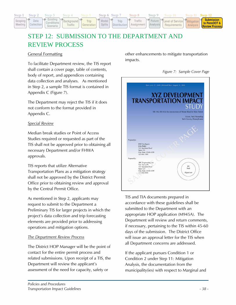
Policies and Procedures Transportation Impact Guidelines - 38 -
STEP 12: SUBMISSION TO THE DEPARTMENT AND REVIEW PROCESS General Formatting
To facilitate Department review, the TIS report shall contain a cover page, table of contents, body of report, and appendices containing data collection and analyses. As mentioned in Step 2, a sample TIS format is contained in Appendix C (Figure 7).
The Department may reject the TIS if it does not conform to the format provided in Appendix C.
Special Review
Median break studies or Point of Access Studies required or requested as part of the TIS shall not be approved prior to obtaining all necessary Department and/or FHWA approvals.
TIS reports that utilize Alternative Transportation Plans as a mitigation strategy shall not be approved by the District Permit Office prior to obtaining review and approval by the Central Permit Office.
As mentioned in Step 2, applicants may request to submit to the Department a Preliminary TIS for larger projects in which the project’s data collection and trip forecasting elements are provided prior to addressing operations and mitigation options.
The Department Review Process
The District HOP Manager will be the point of contact for the entire permit process and related submissions. Upon receipt of a TIS, the Department will review the applicant’s assessment of the need for capacity, safety or
other enhancements to mitigate transportation impacts.
TIS and TIA documents prepared in accordance with these guidelines shall be submitted to the Department with an appropriate HOP application (M945A). The Department will review and return comments, if necessary, pertaining to the TIS within 45-60 days of the submission. The District Office will issue an approval letter for the TIS when all Department concerns are addressed.
If the applicant pursues Condition 1 or Condition 2 under Step 11: Mitigation Analysis, the documentation from the municipality(ies) with respect to Marginal and
Figure 7: Sample Cover Page
Policies and Procedures Transportation Impact Guidelines - 39 -
Significant Degradation as well as the proposed ATP shall be submitted separate from the TIS.
If the Department approves the Marginal or Significant Degradation, related correspondence and the ATP shall be included in the appendix of the final TIS document. If the applicant pursues a Design (LOS) Waiver, the waiver request shall also be submitted as a stand alone document.
If approved by the Department, the Design Waiver - LOS request as well as the approval shall be included in the appendix of the final TIS along with all documentation of applicant’s attempts to comply with Condition 1 or 2.
The TIS and associated mitigation(s), if any, must be identified and agreed to by the Department before the applicant submits final HOP engineering plans for review.

Policies and Procedures I-1 Transportation Impact Guidelines
I. REFERENCES
Policies and Procedures I-2 Transportation Impact Guidelines
A Policy on Geometric Design of Highways and Streets, Fifth Edition, 2004, AASHTO. Also known as
the “Green Book.”
Access to and Occupancy of Highway by Driveways and Local Roads (67 Pa. Code, Chapter 441)
Design Manual Part 1A Department Publication 10A
Design Manual, Part 2, Department Publication 13M
Guidelines for the Design of Local Roads and Streets, Department Publication 70M
Highway Occupancy Permit Handbook, Department Publication 282
Roadway Construction Standards, Department Publication 72M
Smart Transportation Guidebook: Planning and Designing Highways and Streets that Support
Sustainable and Livable Communities, NJDOT and Department, March 2008.
Traffic Engineering Manual, Department Publication 46
Traffic Signal Design Handbook, Department Publication 149
Traffic Signal Standards, Department Publication 148
Traffic Impact Analyses for Site Development: An ITE Proposed Recommended Practice, ITE (2005)
HCM 2000
Guide to Roundabouts, Department Publication 414

Policies and Procedures A-1 Transportation Impact Guidelines
A. APPENDIX A: GLOSSARY
Policies and Procedures A-2 Transportation Impact Guidelines
AVERAGE TRIP RATE – is the weighted average of the number of vehicle trip or trip ends per unit of independent variable.
ACCESS – is the ability to enter or leave a public street or highway from an abutting private property or other public street.
ACCESS MANAGEMENT – is the control and regulation of the spacing and design of driveways, ramps, medians, median openings, traffic signals, and intersections on arterial roads to improve safe and efficient traffic flow on the road system.
AVERAGE DAILY TRAFFIC – is the average number of vehicles crossing a specific point on a roadway on any given day.
AVERAGE TRAVEL SPEED – means the average speed of a traffic stream computed as the length of a highway segment divided by the average travel time of vehicles traversing the segment, in miles per hour.
ALTERNATIVE TRANSPORTATION PLAN – is a plan prepared by the applicant to address significant degradation of LOS. It encompasses a variety of multi-modal and congestion management strategies for improving the study area and transportation network.
BACKGROUND TRAFFIC – refers to an estimate of future traffic within the vicinity of the proposed development, without the site development traffic, but with existing traffic adjusted for expected growth, and addition of traffic from major vested projects.
CAPACITY – means the maximum rate of flow at which persons or vehicles can be reasonably expected to traverse a point or uniform segment
of a lane or roadway during a specific time period under prevailing roadway, traffic, and control conditions; usually expressed as vehicles per hour (VPH) or persons per hours.
CRASH RATE – number of crashes per million vehicle miles traveled in a given segment of roadway.
DEPARTMENT – The Pennsylvania Department of Transportation.
DESIRED OPERATING SPEED - the speed of traffic that best reflects the function of the roadway and surrounding land use context.
DESIGN SPEED – is the speed used to determine the design features of the roadway.
DESIGN HORIZON YEAR – is the year for which the roadway is designed.
FHWA – The Federal Highway Administration is the division of the United States Department of Transportation that administers the federally funded transportation program and is responsible for disbursing federal highway funds to the states.
GRAVITY MODEL – is a mathematical model used to estimate the number of trips that will be drawn to a development based on population and travel time. In the case of a proposed retail development project, it is the attraction of the population of a segment of market to the site. In the case of a residential project, it is the attraction of the location of employment opportunities and in the case of an employment center; it is the residential locations of potential employees. Typically, a gravity model is represented by the following equation:
Policies and Procedures A-3 Transportation Impact Guidelines
(Segment Population)2 Travel Time to Site
HOMOGENEOUS CRASH RATES – The Department monitors crash rates for different types and classes of highways across Pennsylvania. These rates form the base for comparison against the actual rates for the roadway segments within the TIS study areas.
INTERNAL CAPTURE RATE – is the percentage of the total number of trips from a site that are contained within on-site circulation systems only.
ITE TRIP GENERATION – is the most widely used reference source, published by the Institute of Transportation Engineers (ITE) since 1976, for trip generation data, by traffic engineers and transportation planners for site level planning and analysis.
LAND DEVELOPMENT PROCESS – the process by which municipalities review, approve, or reject land development proposals. The land development process is governed by the Municipalities Planning Code.
LAND USE CONTEXT – a land area comprising a unique combination of different land uses, architectural types, urban form, building density, roadways and topography and other natural features. See the Smart Transportation Guidebook for the seven (7) contexts. One is rural and the remaining six (6) are considered urban in this document.
LEVEL OF SERVICE – a qualitative measure describing the operational conditions within a section of roadway or at an intersection that includes factors such as speed, travel time,
ability to maneuver, traffic interruptions, delay and driver comfort. Level of service is described as a letter grade system (similar to a school grading system) where delay (in seconds) is equivalent to a certain letter grade from A through F.
LIMITED-ACCESS FACILITY – means a street or highway especially designed for through traffic that owners or occupants of abutting land or other persons have no right or easement of access.
LOS DROP – represents a change in letter grade. Generally, all LOS drops must be mitigated to the no-development scenario LOS.
MARGINAL DEGRADATION – is a degradation in level of service that is within the ranges of LOS A to LOS C in rural areas and LOS A to LOS D in urban areas.
MITIGATION – is that collective process whereby a developer of land makes adequate provisions for the public transportation facilities needed to accommodate the impacts of the proposed development.
MULTI-USE DEVELOPMENT – (as defined by the Urban Land Institute) means land development that includes two or more different types of land uses; for example residential, commercial and industrial.
MUTCD – (Manual on Uniform Traffic Control Devices) This federal publication established the methodology to study, design install and operate signs, signals and pavement markings on a uniform basis across the United States. While PennDOT Regulations follow the MUTCD, there are differences and the traffic engineering
Policies and Procedures A-4 Transportation Impact Guidelines
community is cautioned to refer to PennDOT Publications. PennDOT publications take precedence where there are differences.
NEW DEVELOPMENT – any commercial, industrial, residential, or other project which involves new construction, enlargement, reconstruction, redevelopment, relocation, or structural alteration and which is expected to generate additional vehicular traffic.
OFF-SITE IMPROVEMENTS – those capital improvements which are not on-site improvements.
ON-SITE IMPROVEMENTS – all improvements constructed on the applicant’s property, or the improvements constructed on the property abutting the applicant’s property necessary for the ingress or egress to the applicant’s property, and required to be constructed by the applicant pursuant to any municipal ordinance, including, but not limited to, the municipal building code, subdivision and land development ordinance, Planned Residential Development (PRD) regulations, and zoning ordinance.
PASS-BY TRIPS – trips that are attracted to a site from existing traffic passing the site on the adjacent street or roadway that provides direct access to the site.
PEAK-HOUR FACTOR (PHF) – is the ratio of the hourly volume to four times the peak 15-minutes volume.
RIGHT-OF-WAY (ROW) – an area of land that is used by the public for travel and for the location of utilities.
RURAL AREAS – are areas not included in an urbanized area, a transitioning urbanized area, an urban area or a community.
SIGNIFICANT DEGRADATION – is a degradation in level of service below LOS C in rural areas and LOS D in urban areas.
TRAFFIC VOLUME – is the number of vehicles passing a point on a highway during a specific time period.
TRANSPORTATION IMPACT ASSESSMENT – a limited analysis and evaluation of the impact of development of sites not warranting a Transportation Impact Study conducted under the supervision of a Pennsylvania Registered Professional Engineer. The purpose of the Transportation Impact Assessment is to conduct a limited evaluation to determine the key development impacts at a specific intersection(s) location.
TRANSPORTATION IMPACT STUDY – analyses of the impact of development conducted under the supervision of a Pennsylvania registered Professional Engineer to determine the full impact of proposed development on the transportation system.
TRIP – is a single or one way directional movement. Transportation engineers & planners refer to trips as “internal,” “external,” or “through.” Internal trips have both origin and destination within a particular projects area. External trips have only one end within the project area. Through trips neither originate or end within the analysis area, but pass through it.
Policies and Procedures A-5 Transportation Impact Guidelines
TRIP DISTRIBUTION – is the arrival and departure patterns for trips to and from the site by geographic area.
TRIP END – is a term denoting the origin or the destination end of the trip in question.
TRIP GENERATION RATE – are average rates of vehicular travel to and from a development, usually cited per square foot, per housing units or per acre.
TRIP GENERATION – is the total number of vehicular trips going to and from a particular land use on a specific site during a specific time period.
Policies and Procedures B-1 Transportation Impact Guidelines
B. APPENDIX B: SCOPING MEETING APPLICATION & AGENDA
Policies and Procedures B-2 Transportation Impact Guidelines
Scoping Meeting Agenda
1) Background of Proposed Project a) Location and Type of Project b) Status in Land Development Process c) Site Plan Discussion
i) Proposed site access ii) Proposed land uses iii) Community linkages (access to neighboring properties, cross easements, pedestrian and transit
accommodations) iv) Adjacent properties
2) Review of Study Area (5-Mile Radius Map) a) Land Use Context (Refer to Smart Transportation Guidebook) b) Known Congestion Areas and Safety Concerns c) Known Historical or Environmental Constraints d) Pedestrian/Bike Review: Community Centers, Parks, Schools etc e) Transit Review (current routes/stops)
3) Existing Planning Information a) Comprehensive Plans b) Act 209 Plans c) Access Management Ordinances/Plans d) Zoning/Land Use in the Study Area e) Known projects/developments with HOP approval or approved TIS
4) Study Area a) Proposed Project Location/Best Access Plan b) Proposed Study Roadways
i) Roadway Type (Present/Future) ii) Location of Structures iii) Current Speed, Desired Operating Speed iv) Existing Right-Of-Way
c) Proposed Study Intersections i) Type of Control (Stop/Signals) ii) Coordinated Signals, Is Expansion of Study area required/needed?
5) Trip Generation a) Methodology Used b) Anticipated number of trips c) Modal Split Reductions
6) Approval of Data Collection Elements and Methodologies to be used for evaluation a) Turning Movement and 24-Hour Count Parameters b) Balancing of Traffic Volumes / Seasonal Adjustment Factors c) Gap, Queue Length, Turn Lane and Sight Distance Studies d) Analysis Software
7) Approval of Analysis Years, Growth Rates a) Opening Year and Design Horizon Year
8) Design Criteria a) Lane/Roadway Widths, Design Speeds and LOS Criteria
9) Miscellaneous Department Discussions a) Funding/Funded Projects b) Right-of-Way c) Recording of Permit d) Condition Statements e) Expedited Review Requested f) Critical Milestones
Policies and Procedures B-3 Transportation Impact Guidelines
TRANSPORTATION IMPACT STUDY (TIS) SCOPING MEETING APPLICATION
Scoping Meeting Date: _______________________________________________________________________ Applicant: __________________________________________________________________________________ Applicant’s Consultant: _______________________________________________________________________ Applicant’s Primary Contact: ___________________________________________________________________
(Attach a list of meeting attendees along with phone numbers and email addresses) (1) LOCATION OF PROPOSED DEVELOPMENT: (Attach location map if available)
PennDOT Engineering Dist.: ____ - ____ County: _____________________________________
Municipality: __________________________________________________________________
State Route(s) (SR): ____________________________________________________________
Segment(s): _____________________________ Offset(s):______________________________ (2) DESCRIPTION OF PROPOSED DEVELOPMENT: (Attach site plan if available)
Proposed site access: ___________________________________________________________ Proposed land uses: ____________________________________________________________ Community linkages (access to neighboring properties, cross easements, pedestrian and transit
accommodations): ________________________________________________________
________________________________________________________________________
Policies and Procedures B-4 Transportation Impact Guidelines
(3) DEVELOPMENT SCHEDULE AND STAGING:
Anticipated Opening Date: ________________
Full Buildout Date: ______________________
Describe Proposed Development Schedule/Staging:
(4) TRIP GENERATION: (Use the most recent edition of “Institute of Transportation Engineers (ITE)
Trip Generation,” unless the Department approves another source. Non-ITE methods must be fully justified based on surveys of multiple sites of the same land use type and size.)
Trip generation for the proposed development will be based on:
_____ ITE Trip Generation Manual.
(List proposed development land uses and associated ITE Land Use Codes)
_____ Other independent surveys. (Attach justification for non-ITE methods)
List land development and trip generation information, as appropriate. If necessary, attach additional sheets to indicate additional land uses or development phases.
Peak Hour Trips
Land Use Size Daily Trips Inbound Outbound
(1)
(2)
(3)
(4)
(5)
(6)
Totals 0 0 0
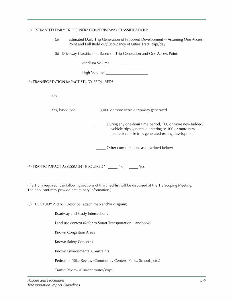
Policies and Procedures B-5 Transportation Impact Guidelines
(5) ESTIMATED DAILY TRIP GENERATION/DRIVEWAY CLASSIFICATION:
(a) Estimated Daily Trip Generation of Proposed Development -- Assuming One Access Point and Full Build out/Occupancy of Entire Tract: trips/day
(b) Driveway Classification Based on Trip Generation and One Access Point:
Medium Volume: ___________________
High Volume: ______________________
(6) TRANSPORTATION IMPACT STUDY REQUIRED?
_____ No _____ Yes, based on: _____ 3,000 or more vehicle trips/day generated
_____ During any one-hour time period, 100 or more new (added) vehicle trips generated entering or 100 or more new (added) vehicle trips generated exiting development
_____ Other considerations as described below: (7) TRAFFIC IMPACT ASSESSMENT REQUIRED? _____ No _____ Yes ___________________________________________________________________________________________
(If a TIS is required, the following sections of this checklist will be discussed at the TIS Scoping Meeting. The applicant may provide preliminary information.) (8) TIS STUDY AREA: (Describe; attach map and/or diagram)
Roadway and Study Intersections Land use context (Refer to Smart Transportation Handbook) Known Congestion Areas Known Safety Concerns Known Environmental Constraints Pedestrian/Bike Review (Community Centers, Parks, Schools, etc.) Transit Review (Current routes/stops)
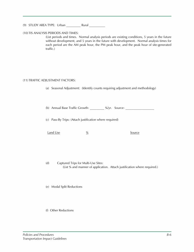
Policies and Procedures B-6 Transportation Impact Guidelines
(9) STUDY AREA TYPE: Urban _________ Rural __________ (10) TIS ANALYSIS PERIODS AND TIMES:
(List periods and times. Normal analysis periods are existing conditions, 5 years in the future without development, and 5 years in the future with development. Normal analysis times for each period are the AM peak hour, the PM peak hour, and the peak hour of site-generated traffic.)
(11) TRAFFIC ADJUSTMENT FACTORS:
(a) Seasonal Adjustment: (Identify counts requiring adjustment and methodology)
(b) Annual Base Traffic Growth: _________ %/yr. Source: __________________
(c) Pass-By Trips: (Attach justification where required)
Land Use % Source
(d) Captured Trips for Multi-Use Sites: (List % and manner of application. Attach justification where required.)
(e) Modal Split Reductions (f) Other Reductions
Policies and Procedures B-7 Transportation Impact Guidelines
(12) OTHER PROJECTS WITHIN STUDY AREA TO BE ADDED TO BASE TRAFFIC: (Identify proposed developments with issued permits that need to be included.)
(13) TRIP DISTRIBUTION AND ASSIGNMENT:
(Describe; explain/justify; attach diagram and related information.) (14) Approval of Data Collection Elements and Methodologies :
Location Period Type
(15) CAPACITY/LOS ANALYSIS:
Location Period Type
(16) ROADWAY IMPROVEMENTS/MODIFICATIONS BY OTHERS TO BE INCLUDED: (Projects programmed for construction or other developments with issued permits.)
Policies and Procedures B-8 Transportation Impact Guidelines
(17) OTHER NEEDED ANALYSES:
(a) Sight Distance Analysis: (Required for all site access driveways; identify other locations)
(b) Signal Warrant Analysis:
(Identify locations) (a) Required Signal Phasing/Timing Modifications:
(Determine for all signalized intersections; specify methodology.) (d) Traffic Signal Corridor/Network Analysis:
(Identify locations/methodology) (e) Analysis of the Need for Turning Lanes:
(Identify locations/methodology) (f) Turning Lane Lengths:
(Identify methodology to be used)
Policies and Procedures B-9 Transportation Impact Guidelines
(g) Left Turn Signal Phasing Analysis: (Identify locations/methodology)
(h) Queuing Analysis:
(Identify locations/methodology) (i) Gap Studies:
(Identify locations/methodology) (j) Crash Analysis:
(Identify locations)
(k) Weaving Analysis:
(Identify locations) (l) Other Required Studies:
(Specify locations/methodology)
Policies and Procedures B-10 Transportation Impact Guidelines
(18) ADDITIONAL COMMENTS OR RECOMMENDATIONS RELATIVE TO THE SCOPE OF THE TIS: __________________________________________________________________ Date: ____________ Signature of Applicant’s Engineer __________________________________________________________________ Date: ____________ Signature of District Traffic PennDOT Representative __________________________________________________________________ Date: ____________ Signature of District Permit PennDOT Representative (if present) __________________________________________________________________ Date: ____________ Signature of Municipal Traffic Representative

Policies and Procedures C-1 Transportation Impact Guidelines
C. APPENDIX C: SAMPLE TIS
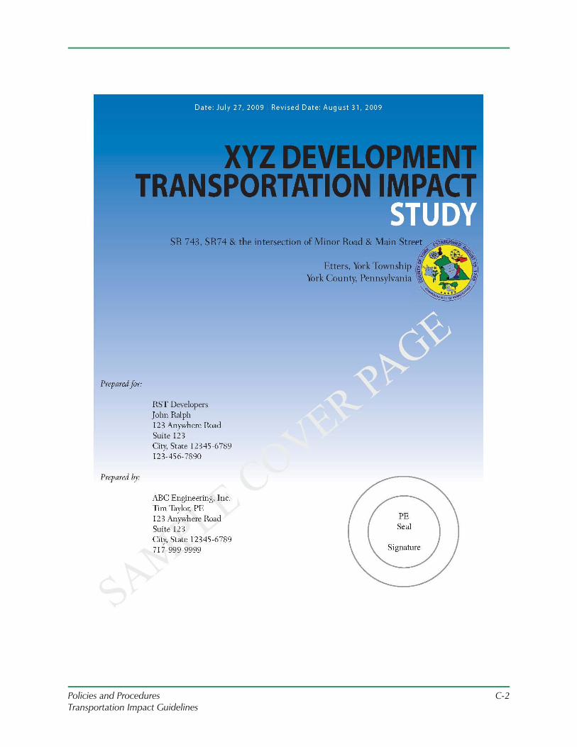
Policies and Procedures C-2 Transportation Impact Guidelines
Policies and Procedures C-3 Transportation Impact Guidelines
Transportation Impact Study (TIS) Format Guidelines
The purpose of the TIS will be to demonstrate the overall impact of traffic generated by the proposed development on the transportation study area. The report structure should follow the Table of Contents provided in the Appendix. Following are elements that need to be addressed in each section of the report. These elements should be presented as discussed and agreed upon during the Scoping Meeting.
It should be noted that all Figures, concepts plans, calculations, etc. are to be contained in the Appendix of the report, but should be discussed and referenced in the appropriate sections as shown.
Executive Summary
The executive summary should be 2 or 3 pages long and concisely cover the project description, impact of the proposed development, proposed methods of mitigation, design waivers requested, and financial responsibilities.
A final executive summary can be greater than 3 pages and include any and all memorandum of understandings, agreements including obligation dates, major milestones, and approved or denied design waivers. The final summary should list any and all traffic impacts identified and mitigation options.
Introduction/Project Summary
A brief, descriptive summary of the analysis undertaken in the study must be included; any assumptions used in the traffic analysis must be identified. The following items should also be addressed:
• Land Use Context (Existing/Proposed)
• Study Area, Transportation Facilities
• Figure 1: Study Area Map included in Appendix, and description of the study area and boundaries defined verbally.
• Figure 2: A site plan (1:50 scale minimum). Lot size, building size(s) and types (retail etc) and location shall be clearly defined on the map/plans.
• Discussion and/or illustration of the site layout identifying the internal traffic circulation patterns, location of existing and proposed access points. Pedestrian crossings or paths should be identified, as well as locations for drive thru facilities and fuel pumps. Project phasing (if applicable) and schedules should be provided identifying the anticipated opening date, anticipated completion years for each phase of development and the anticipated full build out completion date.
Policies and Procedures C-4 Transportation Impact Guidelines
Data Collection
Raw data collected as part of the study in accordance with the scoping meeting shall be contained in Appendix, however a brief summary of the data collected as well as methodology used to obtain the data must be included in this section.
Existing Study Area Conditions
This section of the report should cover the existing traffic conditions, land use context, roadway type, traffic controls in the study area. The study area should also be described including the roadway network. Figures for existing traffic volumes (AM, PM, Site Peak/Saturday) as well as existing level of service (LOS) shall be referenced in this section and contained in the appendix.
Turning lane and queue analysis, crash analysis, gap analysis, and travel time studies should be included for discussion in this section as applicable.
Discussion of the need for sidewalks and crosswalk, and other pedestrian facilities shall be evaluated as part of the project. Evaluation of transit facilities, bus routes/service should also be included in this section.
Opening Year Traffic Conditions Without Development
This section shall contain the traffic count data that has been projected to the opening year utilizing background growth factors, as well as appropriate background traffic from permitted developments.
Capacity analysis shall be conducted. Signalized intersections shall be optimized for corridor prioritization if signals are coordinated. Single intersections shall be optimized for the best overall intersection LOS.
Figures shall be included in the Appendix.
Design Horizon Year Traffic Conditions Without Development
This section shall contain the traffic count data that has been projected to the design horizon year utilizing background growth factors, as well as appropriate background traffic from permitted developments.
Capacity analysis shall be conducted. Signalized intersections shall be optimized for either corridor prioritization if signals are coordinated. Single intersections shall be optimized for the best overall intersection LOS.
Committed transportation improvements in place prior to the opening year shall be described and included in the analysis.
Development Description
The description of the proposed development should be presented in this section. Information that should be discussed and included in the appendix should include but not be limited to:
Policies and Procedures C-5 Transportation Impact Guidelines
• Proposed site access including distance from adjacent intersections and proposed control/movements. Discussion should be provided regarding how access relates to internal circulation and design.
• Sight Distance Analysis (Desirable, Safe Stopping Sight Distance and Existing/Measured Sight Distance)
• Trip Generation
• Pass-By and Internal Capture Trips
• Trip Distribution/Assignment. Methods of assumption shall be provided in this section, as well as back up information for verification of calculations.
• If a post development study is necessary, it should be discussed here, including what financial security will be provided in the form and amount for the study and required mitigation.
Opening Year Traffic Conditions With Development
This section shall contain the opening year traffic volumes and capacity analysis discussion referring to the Figures contained in the Appendix.
As with the No Development Opening Year analysis, optimized signal timings should be utilized.
Turning lane and queue analysis, gap analysis, travel time studies should be included in this section as applicable.
Signal warrant analysis, left turn signal phasing analysis, crash analysis, weaving analysis, or other applicable analyses should also be included in this section as applicable.
Design Horizon Year Traffic Conditions With Development
Design horizon year traffic volumes and capacity analysis shall be discussed in this section. Figures and worksheets shall be included in the Appendix as noted.
As with previous analyses, analyses should be performed assuming optimized signal timings.
Turning lane and queue analysis should be discussed in this section. Auxiliary lanes and proposed lengths should be presented as appropriate. Alternative access locations should be discussed as appropriate.
Signal warrant analysis should be discussed in this section and included in the Appendix as noted.
Mitigation Identification and Recommendations
This section of the report should identify what mitigation measures are needed to meet LOS requirements and to address the traffic impacts of the project. A cost estimate and concept plan of the improvements necessary to mitigate the LOS drops is required to serve as baseline information.
Policies and Procedures C-6 Transportation Impact Guidelines
Final access design shall address both traffic flow and highway safety considerations, which should be discussed succinctly in this section.
A description of the proposed mitigations, arranged by location and type of mitigation should be included in this section. A cost estimate and concept plans of proposed mitigations shall be prepared and included in the Appendix. The proposed mitigations must be constructible improvements; if right-of-way is a concern, the ability to obtain the necessary right-of-way must be specifically identified. Analysis of Proposed Mitigations shall be discussed and capacity analyses included in the Appendix as noted.
If post development condition monitoring is requested by the Department it should be discussed in this section. Elements to include in the discussion include what analysis will be provided to substantiate recommended improvements, optimize signal timings, or to determine if a traffic signal is warranted. If improvements are necessary as a result of the intersection monitoring, the applicant, or his/her successor, shall be responsible for the full expense of designing and constructing the necessary improvements. The Department may require financial security, a condition statement with these terms specifying the duration of the monitoring, as well as the reason for or extent of the monitoring.
If an Alternative Transportation Plan (ATP) is proposed as mitigation, it should be provided as a separate document and referred to in this section. The Department will require concurrence from the municipality regarding the ATP which should be included in the final TIS correspondence section of the Appendix as well as the ATP, if approved by the Department.
If a Design (LOS) Waiver is pursued, it shall be submitted separate from the TIS and referred to in this section. If approved by the Department, the Design (LOS) Waiver request and approval shall be incorporated into the appendix of the final TIS document.
Conclusions
This section shall be a brief, concise description of the study findings, acceptable to the Department, and consistent with Publication 282. Proposed development plans shall include the recommended mitigation improvements to address future design year LOS and transportation network needs.
Appendices:
The appendices shall be clearly marked and tabbed appropriately.
Traffic Count Data:
Table 1: Levels of Service Summary
Table 2: Queue Length Summary
Existing Conditions:
Figure 1: Study Area
Figure 2: Site Plan
Policies and Procedures C-7 Transportation Impact Guidelines
Figure 3: Existing Volume/LOS
Figure 3a: Existing Signal Plan (if applicable)
Figure 4: Trip Distribution Percentage and Volumes
Opening Year Conditions:
Figure 5a: Opening Year Traffic Volumes without Development (AM, PM, Site Peak)
Figure 5b: Opening Year Traffic Volume without Development & with Committed Development
Figure 5c: Opening Year Traffic Volumes with Development
Figure 5d: Opening Year Traffic Volumes with Development & Committed Development
Figure 5e: Opening Year Levels of Service without Development
Figure 5f: Opening Year Levels of Service without Development & with Committed Development
Figure 5g: Opening Year Levels of Service with Development
Figure 5h: Opening Year Levels of Service with Development & Committed Development
Figure 5i: Opening Year Levels of Service with Development & Recommended Mitigation
Figure 5j: Opening Year Levels of Service with Development, Committed Development, & Recommended Mitigation
Design Horizon Year Conditions:
Figure 6a: Design Horizon Year Traffic Volumes without Development (AM, PM, Site Peak)
Figure 6b: Design Horizon Year Traffic Volumes without Development & with Committed Development
Figure 6c: Design Horizon Year Traffic Volumes with Development
Figure 6d: Design Horizon Year Traffic Volumes with Development & Committed Development
Figure 6e: Design Horizon Year Levels of Service without Development
Figure 6f: Design Horizon Year Levels of Service without Development & with Committed Development
Figure 6g: Design Horizon Year Levels of Service with Development
Figure 6h: Design Horizon Year Levels of Service with Development & Committed Development
Policies and Procedures C-8 Transportation Impact Guidelines
Figure 6i: Design Horizon Year Levels of Service with Development & Recommended Mitigation
Figure 6j: Design Horizon Year Levels of Service with Development, Committed Development & Recommended Mitigation
List of Committed Developments Site Photographs Existing Conditions (Sketches, Transit Data etc. ) Turning Movement Counts/24-Hour Volumes Growth Rate Information Seasonal Adjustment and Balancing Calculations Intersection/Roadway Traffic Volume Spreadsheets Trip Generation Worksheets Capacity and Queue Analysis Worksheets Crash Analysis Gap Study Traffic Signal Warrant Analysis Turn Lane Analysis Correspondence Transportation Impact Study Scoping Meeting Application Roadway Characteristics Checklist Concept Plans and Cost Estimates Alternative Transportation Plan (if applicable), bound separately Approved Alternative Transportation Plan (If applicable) Design (LOS) Waiver Request/Approval (if applicable)
Policies and Procedures D-1 Transportation Impact Guidelines
D. APPENDIX D: GAP, QUEUE AND TRAVEL TIME STUDIES
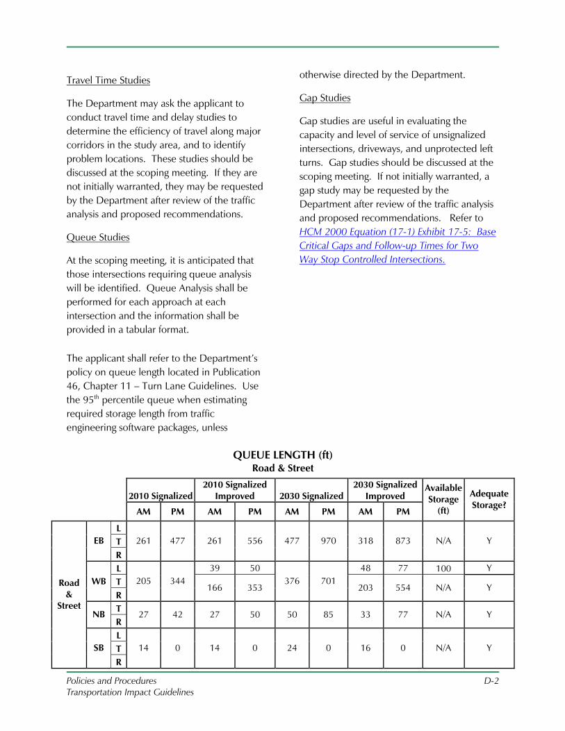
Policies and Procedures D-2 Transportation Impact Guidelines
Travel Time Studies
The Department may ask the applicant to conduct travel time and delay studies to determine the efficiency of travel along major corridors in the study area, and to identify problem locations. These studies should be discussed at the scoping meeting. If they are not initially warranted, they may be requested by the Department after review of the traffic analysis and proposed recommendations.
Queue Studies
At the scoping meeting, it is anticipated that those intersections requiring queue analysis will be identified. Queue Analysis shall be performed for each approach at each intersection and the information shall be provided in a tabular format.
The applicant shall refer to the Department’s policy on queue length located in Publication 46, Chapter 11 – Turn Lane Guidelines. Use the 95th percentile queue when estimating required storage length from traffic engineering software packages, unless
otherwise directed by the Department.
Gap Studies
Gap studies are useful in evaluating the capacity and level of service of unsignalized intersections, driveways, and unprotected left turns. Gap studies should be discussed at the scoping meeting. If not initially warranted, a gap study may be requested by the Department after review of the traffic analysis and proposed recommendations. Refer to HCM 2000 Equation (17-1) Exhibit 17-5: Base Critical Gaps and Follow-up Times for Two Way Stop Controlled Intersections.
QUEUE LENGTH (ft) Road & Street
2010 Signalized 2010 Signalized
Improved 2030 Signalized 2030 Signalized
Improved
AM PM AM PM AM PM AM PM
Available Storage
(ft)
Adequate Storage?
L T EB
R
261 477 261 556 477 970 318 873 N/A Y
L 39 50 48 77 100 Y WB T
R
205 344 166 353
376 701 203 554 N/A Y
T NB R
27 42 27 50 50 85 33 77 N/A Y
L T
Road &
Street
SB
R
14 0 14 0 24 0 16 0 N/A Y
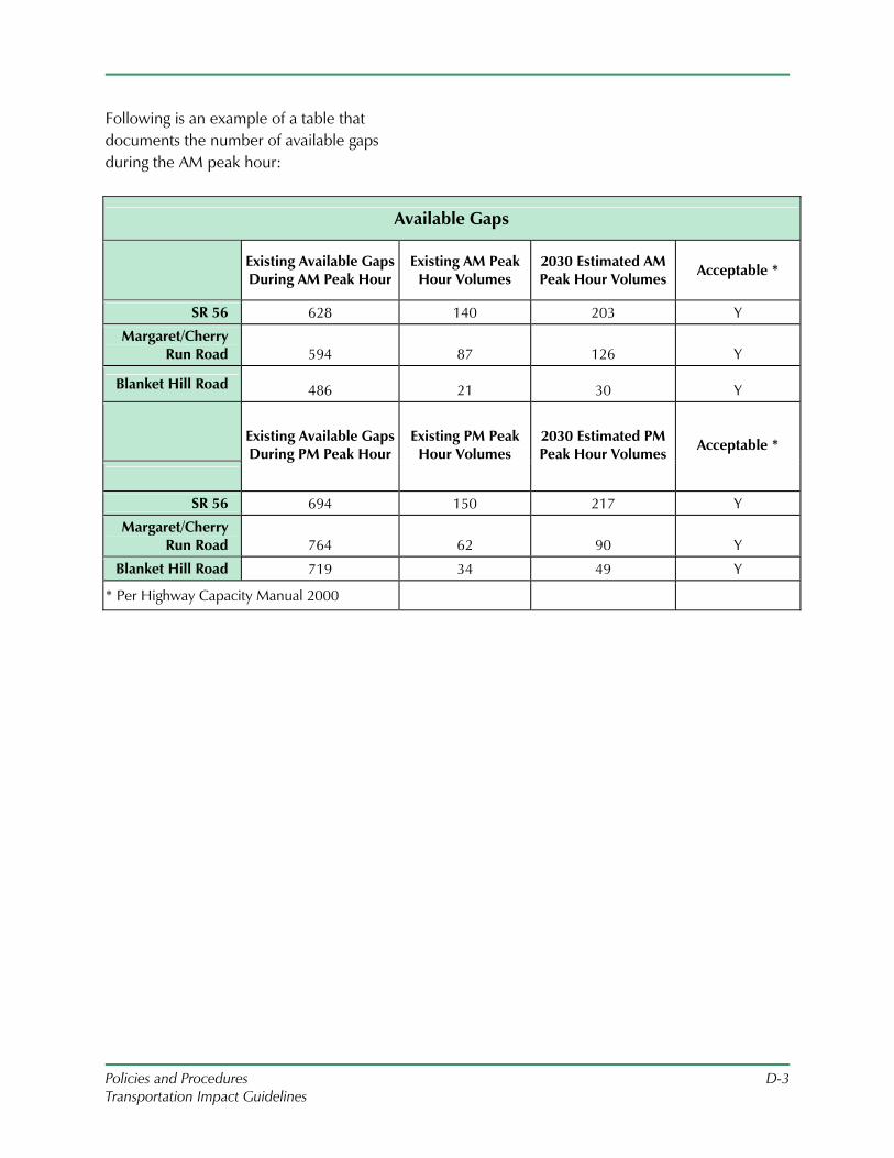
Policies and Procedures D-3 Transportation Impact Guidelines
Following is an example of a table that documents the number of available gaps during the AM peak hour:
Available Gaps
Existing Available Gaps During AM Peak Hour
Existing AM Peak Hour Volumes
2030 Estimated AM Peak Hour Volumes Acceptable *
SR 56 628 140 203 Y
Margaret/Cherry Run Road 594 87 126 Y
Blanket Hill Road 486 21 30 Y
Existing Available Gaps During PM Peak Hour
Existing PM Peak Hour Volumes
2030 Estimated PM Peak Hour Volumes Acceptable *
SR 56 694 150 217 Y
Margaret/Cherry Run Road 764 62 90 Y
Blanket Hill Road 719 34 49 Y
* Per Highway Capacity Manual 2000
Policies and Procedures E-1 Transportation Impact Guidelines
E. APPENDIX E: ALTERNATIVE TRANSPORTATION PLAN STRATEGIES
Policies and Procedures E-2 Transportation Impact Guidelines
Alternative Transportation Plan Mitigation Strategies
As indicated in Step 11, Mitigation Analysis, it will not always be feasible or desirable to modify intersections to mitigate LOS drops. Such modifications could have excessive community or environmental impacts, or they might be less valuable to the community than other strategies which abet more comprehensive transportation improvements.
A variety of mitigation strategies are available for consideration in the development of an Alternative Transportation Plan, while some of the strategies may not mitigate LOS drops, they may still have significant value as congestion management strategies. Developer costs for funding these strategies should be similar to costs that would be assumed by the developer if they had funded physical improvements to roadways and intersections proximate to the development in order to achieve an acceptable LOS. All of the mitigation strategies should involve coordination with local officials, and receive approval by the municipal governing body. Following are examples of elements that can be incorporated in the alternative transportation plan.
Alternate Routes
As an alternative to adding capacity to existing intersections on major roads adjacent to the development, or as a supplement to such measures, the applicant should consider the option of improving the connectivity of the area roadway network. A well-connected roadway network can better serve the needs of area motorists, since it provides a greater choice of routes; and better serve pedestrians
and bicyclists, by allowing them to travel on streets with lower traffic volumes.
Typically, this strategy would consist of altering the network such that area residents and workers can make better use of other arterial and collector roadways parallel to the major roadways. The Department will consider this mitigation strategy even if it is physically feasible to add capacity on the state highways adjacent to the development. One consideration will be whether the proposed improvement on the state highway would result in a roadway design out of character with other intersections or segments along the roadway.
It should be possible in many cases to estimate the traffic volumes that will be diverted to other intersections, thus reducing volumes at intersections on the major roadway. An analysis will reveal whether this strategy would permit the study area intersections to achieve desirable levels of service; even if these levels are not achieved, because of the benefits of a well-connected network, the Department will still consider this as a possible strategy.
In some cases, installation of a signal at existing unsignalized intersections proximate to the subject property, and providing access to the development, will permit the applicant to avoid constructing a new signalized driveway.
Coordination with local officials will be particularly important for this mitigation strategy. Any proposal for improving the roadway network should avoid significant diversion of traffic to local roads. The municipal transportation plan or official map should be consulted to determine if desired
Policies and Procedures E-3 Transportation Impact Guidelines
new roadway links in the area of the development are identified.
Access Management Plans
An Access Management Plan will recommend comprehensive strategies for controlling access points along arterial roadways within the study area, by identifying opportunities for closing, combining or moving existing driveways, and by identifying optimal locations for future driveways and opportunities for frontage and mutual access roads on undeveloped properties.
Access management is a tool to improve vehicular flow and safety for motorist, pedestrians and bicycles through improved control of the location, spacing, design and operation of driveways along a roadway. Preparing and implementing recommendations for improving access management along arterial roadways in the study area, along and proximate to the subject property, is thus a possible mitigation strategy. This strategy should be primarily considered for existing or planned commercial corridors. As part of this strategy, the applicant should coordinate with adjacent landowners and identify the potential for eliminating and/or combining access points, thus reducing the overall number of driveways along the major roadways, and removing them from the influence area of roadway intersections. Ideally, the municipality would pass an ordinance incorporating access management strategies such as minimum driveway spacing, and investigation of shared driveways.
Applicants are encouraged to refer to information from the Department on Access Management Ordinances.
Multi-Modal Plan
A Multi-modal Plan will recommend new facilities, programs, and other strategies for accommodating and encouraging pedestrians, bicyclists and transit users. This should not be limited to the study area, but should prioritize facilities wherever needed in the municipality, and comprehensive strategies for alternative modes.
Pedestrian Facilities
The need for sidewalks and crosswalks, pedestrian signs and signals, and other pedestrian facilities shall be evaluated as part of all development projects. The need for sidewalks is assumed for all projects within urban contexts; the need for sidewalks is assumed as part of any projects within suburban or rural contexts that would generate regular pedestrian activity. In very low-density areas, where the number of existing pedestrians, and pedestrians projected based upon planned development is less than five per day, pedestrians can be accommodated through other means, such as shoulders.
As a mitigation strategy, in addition to installing sidewalks on the subject property, consideration can be given to the installation of sidewalks along other roadway segments in the study area. The applicant should identify key “missing links” along the roadways adjacent to the development, and along other arterial and collector roadways. Provision of an easement to permit installation of a sidewalk not along a public roadway, enabling pedestrian access between key roads, should also be considered. The focus should be on improving the connections between medium- to high-pedestrian generators, thus enhancing
Policies and Procedures E-4 Transportation Impact Guidelines
pedestrian mobility throughout the larger area. The municipal transportation plan or other pedestrian plans should also be consulted.
The applicant should evaluate the need for other pedestrian facilities at intersections and mid-block crossings in the study area, including pedestrian signals, signs and crosswalks. As mentioned in Step 1, applicants must adhere to a core principle of ADA: If pedestrian facilities are provided, they must be accessible to persons with disabilities.
Transit Facilities
The applicant shall evaluate and discuss the potential for increased demand for bus use due to the proposal, addressing whether such increases will increase the number of stops, dwell time, or the frequency of service for existing bus routes in the study area. The applicant shall also evaluate the need for new bus routes. As a mitigation strategy, the applicant could provide funding for planning new transit routes or modification to existing routes, and for the operating costs of such service for the first one to two years of operation.
Improvements to the safety and security of transit stops and low cost design elements, such as transit shelters and sidewalks in proximity to transit stops, should also be considered.
There are a number of transit agencies in Pennsylvania, and initiatives exist to encourage transit oriented development. Applicants are encouraged to visit the Pennsylvania Public Transit Association website and the Department page on public transit by county.
Bicycle Facilities
The applicant should evaluate the need for bicycle facilities on the subject property, whether a bike lane, bicycle-compatible shoulder, or multi-use path. On-road bicycle facilities are of greater priority on arterial and collector roadways. Off-road paths provide the greatest benefit in fairly limited situations – for example, as part of linear recreational or natural areas. This evaluation should consider the opportunity to connect to other bicycle facilities in the study area, and whether there is a comprehensive plan prepared for the municipality, county or regional planning office identifying desirable bicycle facilities within the region. Installed in isolation, bicycle facilities may have minimal value, and the benefit of this mitigation strategy should be viewed accordingly. The applicant may also agree to install bike racks or other bike parking facilities at high bicycle generators in the community, such as parks, schools, and retail centers.
Park and Ride
Park-and-ride lots have great value in reducing the number of vehicular trips on roadways heading into a regional employment destination. For this mitigation strategy, the applicant may provide park-and-ride parking spaces on the subject property, such as by designating such spaces in a retail center parking lot; provide these parking spaces on other properties controlled by the applicant in the region; or rent spaces on other properties within the region. The park-and-ride lot provided by the applicant does not need to be in the study area, but should be positioned convenient to regional arterial roadways or transit lines, and be located between the study
Policies and Procedures E-5 Transportation Impact Guidelines
area and regional employment destination, to better capture motorists from this commuter shed.
Intelligent Transportation Systems
A number of ITS strategies may be funded by the applicant to help offset the traffic impacts of the subject property. Along higher order roadways on which closely spaced traffic signals are not coordinated, the applicant could fund the physical interconnection of signals in order to create a coordinated traffic signal system. The applicant should evaluate different signal phasing plans, and recommend the most efficient plan for the study area corridor. Another option would be the installation of Variable Message Signs (VMS) along regional arterial roadways within five miles of the development, focusing on roadways leading to regional employment centers, in order to better inform motorists of travel conditions on those roadways. In conjunction with VMS, or as a separate strategy, the applicant may fund the installation of traffic cameras along regional arterial roadways, in order to monitor traffic flow and incidents on these roadways. As an umbrella ITS strategy, the applicant could contribute to the development of a traffic “control center,” if there is not one currently in the region of the development.
Traffic Signal Assets Management Plan
A Traffic Signal Assets Management Plan will provide recommendations on signal timing for all intersections within an agreed upon area in order to optimize traffic flow, and detail a strategy for periodic re-evaluation and re-timing of signals in the future. It will also offer recommendations on a preventive maintenance program that can be adopted by
the host municipality and set the funding responsibility by the Applicant.
Sample Alternative Transportation Plan
The alternative transportation plan shall be a bound document submitted to the Department separate of the TIS document. If approved by the Department, the ATP shall be included in the final TIS submitted to the Department. The ATP shall contain the following information:
1) Proposed project overview a. Provide a map that
encompasses the proposed development site as well as the impacted area.
b. Provide the development description.
i. Type of Land use, Size, Trip Generation.
ii. Trip assignment figure. iii. Total traffic volume
assignment figure. iv. Additional information
as needed to describe the extent of the development.
2) LOS Table highlighting the specific
impacts.
3) Picture(s) of intersection(s) impacted.
4) Construction cost estimate for highway improvements, including, but not limited to, R/W and utility costs, which will fully mitigate impacts.
Policies and Procedures E-6 Transportation Impact Guidelines
5) Conceptual plans at a reasonable scale that depicts the highway improvements which will fully mitigate impacts.
6) Conceptual plans at a reasonable scale that depicts highway improvements the applicant intends to implement which will partially but not completely mitigate impacts (as applicable).
7) Detailed justification as to why all or a portion of the highway improvements are not feasible.
8) Detailed justifications as to why foregoing the particular highway improvements will jeopardize neither public safety nor the highway/bridge infrastructure.
9) Proposed ATP a. Description of the ATP. b. Description how the ATP
addresses mitigation (Is it reasonable?).
c. Explanation/documentation of how the ATP will be legally enforced.
d. Cost estimate to implement the ATP.
e. ATP implementation schedule. f. Evidence that all key
stakeholders concur.
10) Signature Lines for District Executive and Central Permit Office Approval