Pearson Edexcel International Advanced Level Geography ... · Pearson Edexcel International...
19
International Advanced Level Geography. Fieldwork guide. March 2016. Version 1 Pearson Edexcel International Advanced Level Geography Research and Fieldwork guide Introduction Students must complete a minimum of two days of fieldwork (excluding research time) to meet the requirements laid out in this specification. It is therefore crucial that students have access to appropriate opportunities for meaningful research. Teachers must also ensure that the fieldwork activities and environments experienced by students allow them to develop and demonstrate the full range, variety and diversity of skills required. Research and fieldwork skills in readiness for assessment (Unit 2) must include: pre-fieldwork planning and research: 1. Identification of the question for investigation 2. Contextualising the investigation primary fieldwork and data collection: 3. Methodology and design 4. Primary data collection, equipment and recording presentation, analysis, conclusions and evaluation: 5. Data processing, analysis and presentation 6. Explanation and conclusions 7. Critically reflecting on the results and process Refer to Appendix 2 page 71 of the specification: Geographical investigation, for more details Fieldwork, research and enquiry-based learning should also support the wider suite of geographical skills, Appendix 1 page 69. Understand the nature and use of different types of geographical information, including qualitative and quantitative data, primary and secondary sources of data, images, factual text and discursive/creative material, digital data, numerical and spatial data and innovative forms of data, including crowd-sourced and ‘big data’ and including dot maps, kite diagrams, linear and logarithmic scales, dispersion diagrams aerial/oblique/ground/satellite images, and GIS. Collect, analyse and interpret such information, and demonstrate the ability to understand and apply suitable analytical approaches for the different information types, including qualitative approaches such as coding and sampling and quantitative approaches such as measures of dispersion, measures of correlation and association from the following statistical tests: t-tests, Spearman’s rank, Chi-Squared, Gini coefficient, Lorenz curves. Undertake informed and critical questioning of data sources, analytical methodologies, data reporting and presentation, including the ability to identify sources of error in data and to identify the misuse of data Communicate and evaluate findings, draw well-evidenced conclusions informed by wider theory, and construct extended written argument about geographical matters.
Transcript of Pearson Edexcel International Advanced Level Geography ... · Pearson Edexcel International...

International Advanced Level Geography. Fieldwork guide. March 2016. Version 1
Pearson Edexcel International Advanced Level Geography Research and Fieldwork guide Introduction
Students must complete a minimum of two days of fieldwork (excluding research time) to meet the
requirements laid out in this specification. It is therefore crucial that students have access to
appropriate opportunities for meaningful research.
Teachers must also ensure that the fieldwork activities and environments experienced by students
allow them to develop and demonstrate the full range, variety and diversity of skills required.
Research and fieldwork skills in readiness for assessment (Unit 2) must include:
pre-fieldwork planning and research:
1. Identification of the question for investigation
2. Contextualising the investigation
primary fieldwork and data collection:
3. Methodology and design
4. Primary data collection, equipment and recording
presentation, analysis, conclusions and evaluation:
5. Data processing, analysis and presentation
6. Explanation and conclusions
7. Critically reflecting on the results and process
Refer to Appendix 2 page 71 of the specification: Geographical investigation, for more
details
Fieldwork, research and enquiry-based learning should also support the wider suite of geographical
skills, Appendix 1 page 69.
Understand the nature and use of different types of geographical information, including
qualitative and quantitative data, primary and secondary sources of data, images, factual text
and discursive/creative material, digital data, numerical and spatial data and innovative forms
of data, including crowd-sourced and ‘big data’ and including dot maps, kite diagrams, linear
and logarithmic scales, dispersion diagrams aerial/oblique/ground/satellite images, and GIS.
Collect, analyse and interpret such information, and demonstrate the ability to understand and
apply suitable analytical approaches for the different information types, including qualitative
approaches such as coding and sampling and quantitative approaches such as measures of
dispersion, measures of correlation and association from the following statistical tests: t-tests,
Spearman’s rank, Chi-Squared, Gini coefficient, Lorenz curves.
Undertake informed and critical questioning of data sources, analytical methodologies, data
reporting and presentation, including the ability to identify sources of error in data and to
identify the misuse of data
Communicate and evaluate findings, draw well-evidenced conclusions informed by wider
theory, and construct extended written argument about geographical matters.

International Advanced Level Geography. Fieldwork guide. March 2016. Version 1
A recent report (Lambert and Reiss 2016 (Institute of education, University of London, 2014/5),
confirms the significance of high quality fieldwork as an integral part of being a competent
geographer. Table 1 presents some reflective ideas that might be considered at the initial stages of
thinking about an investigation. A good piece of enquiry work will likely reinforce some of these
embedded skills and competencies.
Focus Skills and competencies
Application and
evaluation of
knowledge and
understanding
Develops skills in “big data”
Embeds competencies in data handling and statistical
understanding
Helps with skills of literature research and selection of material;
can develop synthesis skills
May help with technology skills, e.g. spreadsheet manipulation
or analysis using GIS
Developing
“deeper”
learning
Helps “see” things differently
Encourages caution and reflectivity in data analysis, as well as
taking geographical meaning
Enables critical thinking and the ability to challenge
Helps with skills of reasoning as well as geographical curiosity.
Social
dimensions
Helps foster independent learning
Creates an atmosphere for co-operation in problem solving
Teaches the skills of procedure which will be transferable to
other situations and subjects.
Greater awareness of ethical considerations as part of the
enquiry process
Table 1
Structure of this guide
The fieldwork support in this teacher’s guide is split into 6 sections:
(1) An overview of the main fieldwork and research themes, plus qualitative and quantitative data
and information
(2) Generic sources to help contextualise the fieldwork
(3) Virtual fieldwork
(4) Minimum fieldwork requirements
(5) Planning and developing an integrated fieldwork strategy
(6) GIS IAL Geography

International Advanced Level Geography. Fieldwork guide. March 2016. Version 1
Section 1 – An overview of the main fieldwork and research themes, plus qualitative and quantitative data and information (Coasts and Urban)
Primary vs Secondary data. Primary data is generally considered to be first hand data collected
by a student themselves (or as part of a group). Secondary data (which may be
part of the research) means information that has already been collected by someone else. In reality
there is some “grey” between these two ideas and approaches, sufficient to say that
you should expect to have a reasonable balance between the two types.
Quantitative data and information is that which includes numbers and numerical data,
whereas qualitative is descriptive and can include things such as photographs or written texts. See
below for what students should know about, in the context of this IAL:

International Advanced Level Geography. Fieldwork guide. March 2016. Version 1
Qualitative
data and
information
a) Use and understand a mixture of methodological approaches, including
using interviews.
Interpret and evaluate a range of source material including textual and
visual sources, such as oral accounts, newspapers, creative media, social
media, aerial/oblique/ground photographs, sketches and drawings.
b) Understand the opportunities and limitations of qualitative techniques
such as coding and sampling, and appreciate how they actively create
particular geographical representations.
c) Understand the ethical and socio-political implications of collecting,
studying and representing geographical data about human communities.
Quantitative
data and
information
a) Understand what makes data geographical and the geospatial
technologies (e.g. GIS) that are used to collect, analyse and present
geographical data.
b) Demonstrate an ability to collect and to use digital, geo-located data,
and to understand a range of approaches to the use and analysis of such
data. Use, interpret and analyse geographical information including dot
maps, kite diagrams, linear and logarithmic scales, dispersion diagrams,
satellite images, GIS.
c) Understand the purposes and difference between the following and be
able to use them in appropriate contexts:
i. descriptive statistics of central tendency and dispersion
ii. descriptive measures of difference and association from the following
statistical tests: t-tests, Spearman’s rank, Chi-Squared; inferential
statistics and the foundations of relational statistics, including measures of
correlation and lines of best fit on a scatter plot
iii. measurement, measurement errors, and sampling

International Advanced Level Geography. Fieldwork guide. March 2016. Version 1
Section 2 - Generic sources to support fieldwork and research
A number of these sources may have information to help contextualise the fieldwork and add
relevance to the issue / topic being studied.
The Field Studies Council have an excellent fieldwork website http://www.geography-
fieldwork.org/index.htm. They also have a range of specialist identification guides (fold out charts)
for many of the fieldwork topics in the specification http://field-studies-
council.org/publications/foldout-charts.aspx
You will also find some useful information from the Barcelona Field Studies website
http://geographyfieldwork.com/Fieldwork%20Methodology.htm
NAFSO (National Association of Field Studies Officers) has a published directory of UK Field Centres
http://www.nafso.org.uk/index.php?option=com_sobi2&catid=2&Itemid=62
The RGS (Royal Geographical Society) have a directory of international field centres (“World
Resister”).
http://www.rgs.org/OurWork/Fieldwork+and+Expeditions/World+Register+of+FieldCentres/World+R
egister+of+Field+Centres.htm
Geofile and Geofactsheet. These publications of a range of topics that may be relevant to
particular topic. Although aimed an AS / A2 audience, they can provide some useful background
reading to contextualise a topic area.
Topic Eye Geography is a new magazine series for students written by leading authors and
examiners. http://crossacademe.co.uk/series/23/a-level-geography
Geography Review and WideWorld are now available online and searchable through an online
magazine subscription service. http://magazines.philipallan.co.uk/Magazines/Geography-
Review.aspx
Newspapers – especially Independent, Guardian, Telegraph, The Times. Also search their blogging
areas for background opinion. Look at local newspapers for a more in-depth focus on local issues
(especially editorial sections).
BBC website. Look at the local section for reactions to particular issues.
YouTube may provide clips of documentaries as well as uploaded local videos.
For stretch search the online databases of the Economist, Ecologist and New Scientist for some
up-to-date and accessible resources.
Also consider subscribing to relevant Twitter and RSS feeds.
Academic articles and literature should also form part of the fieldwork reading. Much of this can be
accessed for free from the internet, or via a school library login, e.g. http://www.jstor.org/

International Advanced Level Geography. Fieldwork guide. March 2016. Version 1
Section 3 - Virtual Fieldwork
Virtual fieldwork, in the context of this specification, is a term that refers to either:
1. Pre and post fieldwork that supports the main focus of the fieldwork opportunities. This might
include Google Maps and Google StreetView for instance, as a tool to select appropriate sites.
Or photographs / video from past field visits (when conditions were different) to demonstrate
particular features / landscapes / process etc. YouTube may be useful in this respect. Virtual
fieldwork may also be used as a tool to help teach field-skills before the visit, or prepare a risk
assessment.
2. A simulation exercise, where, because of constrained circumstances, candidates cannot collect
the data personally in the field. In this instance alternative data will need to be sourced (see
page 24 of the specification).
It should be stressed that virtual fieldwork is not intended to be used as a way of short-cutting or
bypassing the original fieldwork opportunities which are central to the delivery of this specification.
Whilst option 2 (simulation exercise - above) may offer a workable, practical and satisfactory
alternative to real fieldwork, this approach is not without limitations:
• virtual trips cannot replicate real objects (e.g. rocks, plants, smells and noises) – only visual
aspects (e.g. views of landscapes) can easily be simulated
• students may treat a virtual field trip as similar to a computer game and thus not learn the
analytical approaches or problem-solving in the same way as when they are confronted by the
‘real thing’
• a virtual environment cannot recreate the challenges of doing an enquiry in an unfamiliar
setting which develops self-reliance
• it cannot recreate the social benefits of fieldwork, especially the value of residential
experiences
• it is difficult to develop and embed the skills and experiences associated with real fieldwork
(which form part of the assessment)
There are many examples of virtual fieldwork tours on the internet, e.g. British Ecological Survey
http://www.britishecologicalsociety.org/educational/fieldwork/virtual_tours.php . Here, the user is
able to select an environment to investigate and then to see individual transects where data was
collected. Detailed photography allows a realistic simulation of the data collection process, through a
systematic sample.
ArcGIS online gives access to range of industry standard GIS mapping tools with an educational
subscription. This can help with number skills for example. There is also a free, individual
subscription. GIS is also considered at the end of this guide.

International Advanced Level Geography. Fieldwork guide. March 2016. Version 1
Section 4 - Miniumum Fieldwork Requirements IAS students must complete a minimum of two days of fieldwork (excluding research time).
Centres will be required to provide evidence of this fieldwork in the form of a written fieldwork
statement. See Appendix 3, page 73 (below and also available in the specification): Fieldwork
statement.
Students are required to carry out fieldwork in relation to Topic 1: Crowded Coasts or Topic 2: Urban
Problems, Planning and Regeneration.
Undertaking fieldwork in both environments

International Advanced Level Geography. Fieldwork guide. March 2016. Version 1
Section 5 - Planning and developing an integrated fieldwork strategy
Centres must ensure that:
the chosen research and fieldwork investigation is appropriately linked to at least one of the
enquiry questions in Topic 1 or Topic 2
the investigation involves collecting a range of primary data, using both suitable quantitative
and qualitative techniques
secondary sources of data are available for students to use, and these can assist with
answering key questions/hypotheses and provide a geographical context for the investigation
the methods chosen for primary data collection yield data that can be presented and analysed
in appropriate ways, including numerically and statistically
The following are possible suggestions and are not intended as explict or approved
recommednations. Fieldwork and research should be contextualised for a partiuclar local
environment, and wherever possible linked to teaching and learning contained within the specification
topics. Careful consideration should be also given to the follow-up activities so that students are
prepared for the exam. There is no requirement to hand in individual written work or coursework.
It is strongly recommended that centres plan their fieldwork opportunities as part of an integrated
one year strategy, making clear the links between the fieldwork and the knowledge / understating of
the content in Unit 2. In that respect, the order of teaching Units should largely dictate the
programme of fieldwork (or vice-versa).
Good practice should allow for students to follow the geographical investigation process and for
students to be fully engaged in the decision-making processes in relation to their research and
fieldwork investigation.
Geography Subject Advisor support is available here [email protected] for any
enquries relating to the suitablity of any fieldwork or research.

International Advanced Level Geography. Fieldwork guide. March 2016. Version 1
Crowded Coasts: 2.3.3 Coastal ecosystems and environments
Enquiry question: How do coastal ecosystems develop, what is their value and how are
they threatened?
Activity Fieldwork opportunities Pre and post fieldwork
Planning and
research
Locating the study area
(maps / GIS etc).
Designing an investigation:
Identification of a question and aims
linked to geographical theory
Fieldwork equipment considerations to
ensure accuracy and reliability
Discussion of health and safety
Contextualising the study wider significance
of the topic area etc.
Research into relevant background
information, e.g. internet, magazines and
articles
Use of past data to understand scale
Fieldwork design – where and how many
sites (justified)
Possible development /customisation of
recording sheets
Two example
fieldwork
techniques
Ecosystem transect - transects
across the ecosystem look for change,
zonation etc.
Discussion of methods to measure and record
data with reference to secondary data, field
sketches of the data collection sites using
secondary resources and also the sampling
strategy to be employed. Development vs conservation
conflicts – views of different
stakeholders, questionnaires, conflict
matrices, photographic evidence.
Data
presentation
Data presentation using a range of graphs, diagrams and annotations.
Data must be collated prior to presentation.
Analysis of
information
Undertaking simple tests of the secondary data, for example calculating the mean
pebble size at each site (basic statistical tests). Analysing data, drawing conclusions
with reference to the aims of the investigation, evaluating the techniques used and the
conclusions drawn.
Conclusions
and
evaluation
Describe the findings, explain possible reasons and make links between patterns etc.
Students should return to the original predictions/hypotheses. A review of the
fieldwork process (including any additional research information).
Evaluation of methodology, accuracy, validity and reliability of the conclusions.
International Advanced Level Geography. Fieldwork guide. March 2016. Version 1
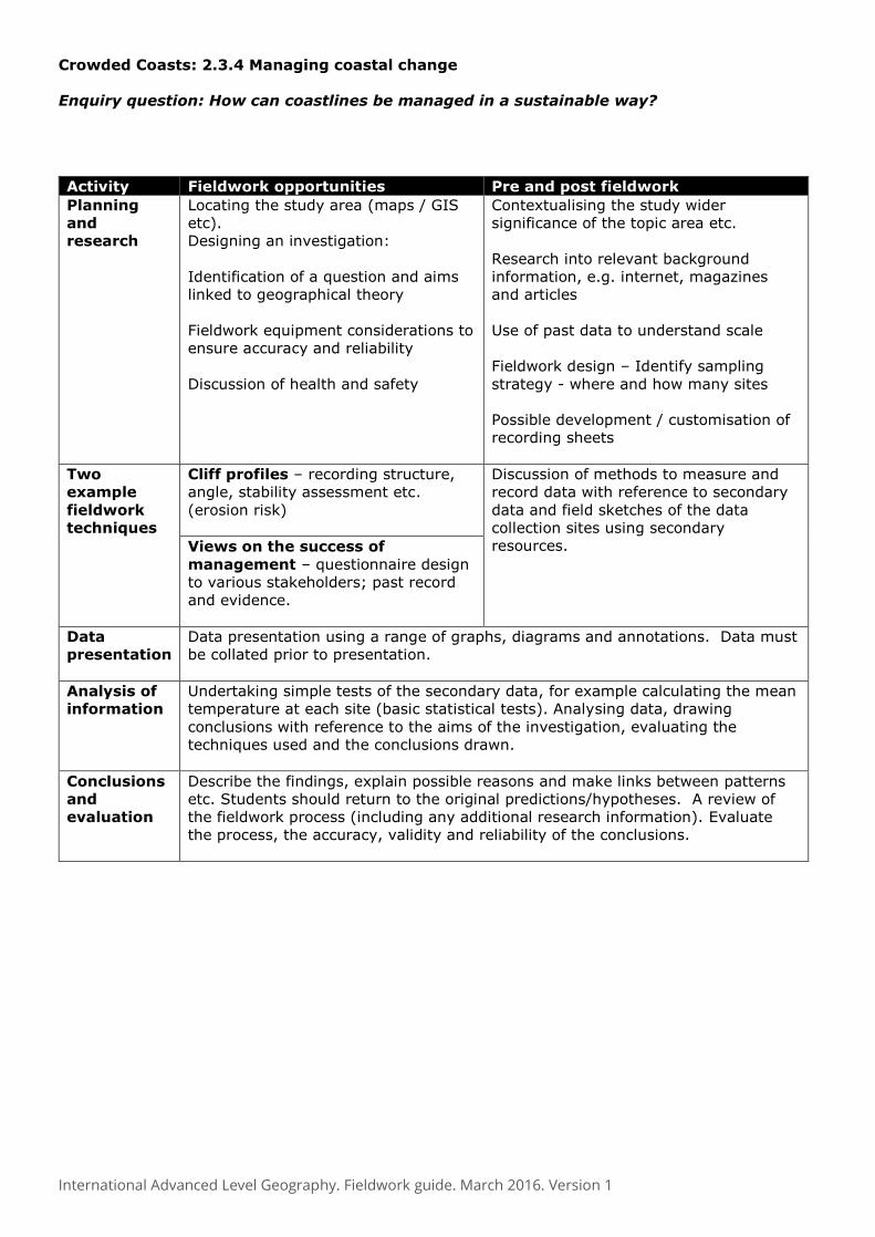
Crowded Coasts: 2.3.4 Managing coastal change
Enquiry question: How can coastlines be managed in a sustainable way?
Activity Fieldwork opportunities Pre and post fieldwork
Planning
and
research
Locating the study area (maps / GIS
etc).
Designing an investigation:
Identification of a question and aims
linked to geographical theory
Fieldwork equipment considerations to
ensure accuracy and reliability
Discussion of health and safety
Contextualising the study wider
significance of the topic area etc.
Research into relevant background
information, e.g. internet, magazines
and articles
Use of past data to understand scale
Fieldwork design – Identify sampling
strategy - where and how many sites
Possible development / customisation of
recording sheets
Two
example
fieldwork
techniques
Cliff profiles – recording structure,
angle, stability assessment etc.
(erosion risk)
Discussion of methods to measure and
record data with reference to secondary
data and field sketches of the data
collection sites using secondary
resources. Views on the success of
management – questionnaire design
to various stakeholders; past record
and evidence.
Data
presentation
Data presentation using a range of graphs, diagrams and annotations. Data must
be collated prior to presentation.
Analysis of
information
Undertaking simple tests of the secondary data, for example calculating the mean
temperature at each site (basic statistical tests). Analysing data, drawing
conclusions with reference to the aims of the investigation, evaluating the
techniques used and the conclusions drawn.
Conclusions
and
evaluation
Describe the findings, explain possible reasons and make links between patterns
etc. Students should return to the original predictions/hypotheses. A review of
the fieldwork process (including any additional research information). Evaluate
the process, the accuracy, validity and reliability of the conclusions.

International Advanced Level Geography. Fieldwork guide. March 2016. Version 1
Urban Problems: 2.4.2 Transport issues in cities
Enquiry question: Why has transport become a key issue in many cities and how can it be
best managed?
Activity Fieldwork opportunities Pre and post fieldwork
Planning
and
research
Locating the study area (maps / GIS
etc).
Designing an investigation:
Identification of a question and aims
linked to geographical theory
Fieldwork equipment considerations
to ensure accuracy and reliability
Discussion of health and safety
Contextualising the study wider
significance of the topic area etc.
Research into relevant background
information, e.g. internet, magazines
nd articles
Use of past data to understand scale
Fieldwork design – where and how
many sites (justified)
Possible development / customisation
of recording sheets
Two
example
fieldwork
techniques
Traffic hotspot maps – recording
location, types, CO2 pollution etc.
Discussion of methods to measure and
record data with reference to
secondary data and field sketches of
the data collection sites using
secondary resources. Views on the success of
management – questionnaire
design to various stakeholders; past
record and evidence, plus location of
schemes
Data
presentation
Data presentation using a range of graphs, diagrams and annotations. Data
must be collated prior to presentation.
Analysis of
information
Undertaking simple tests of the secondary data, for example calculating the
mean temperature at each site (basic statistical tests). Analysing data,
drawing conclusions with reference to the aims of the investigation,
evaluating the techniques used and the conclusions drawn.
Conclusions
and
evaluation
Describe the findings, explain possible reasons and make links between
patterns etc. Students should return to the original predictions/hypotheses.
A review of the fieldwork process (including any additional research
information). Comments on the accuracy, validity and reliability of the
conclusions.

International Advanced Level Geography. Fieldwork guide. March 2016. Version 1
Urban Problems: 2.4.4 Urban regeneration
Enquiry question: How can social, economic and environmental aspects of urban areas be
improved by regeneration?
Activity Fieldwork opportunities Pre and post fieldwork
Planning
and
research
Locating the study area (maps / GIS
etc).
Designing an investigation:
Identification of a question and aims
linked to geographical theory
Fieldwork equipment considerations
to ensure accuracy and reliability
Discussion of health and safety
Contextualising the study wider
significance of the topic area etc.
Research into relevant background
information, e.g. internet, magazines
and articles
Use of past data to understand scale
Fieldwork design – where and how
many sites (justified)
Possible development / customisation
of recording sheets
Two
example
fieldwork
techniques
Regeneration survey – recording
location of flagship buildings, EAQ,
pedestrian flows
Discussion of methods to measure and
record data with reference to
secondary data and field sketches of
the data collection sites using
secondary resources. Views on the success of schemes
– questionnaire design to various
stakeholders;
past record and evidence
Data
presentation
Data presentation using a range of graphs, diagrams and annotations.
Data must be collated prior to presentation.
Analysis of
information
Undertaking simple tests of the secondary data, for example calculating the
mean temperature at each site (basic statistical tests). Analysing data,
drawing conclusions with reference to the aims of the investigation,
evaluating the techniques used and the conclusions drawn.
Conclusions
and
evaluation
Describe the findings, explain possible reasons and make links between
patterns etc. Students should return to the original predictions/hypotheses.
A review of the fieldwork process (including any additional research
information).
Evaluate the accuracy, validity and reliability of the conclusions.

International Advanced Level Geography. Fieldwork guide. March 2016. Version 1
(6) GIS. Context - IAL Geography GIS or Geographical Information Systems are becoming an important part of a 21st century way of
life. GIS has evolved into a technology that is used by a huge number of industries and agencies to
help plan, design, engineer, build and maintain information infrastructures that effects our everyday
lives. There really is no limit to the type of data that can be included in a GIS. Consequently GIS can
be used in a huge range of geographical contexts, and is increasingly being used in real time disaster
management, to quickly map areas of damage (using GPS), identify services, locate possible refugee
sites etc.
The aim of this short paper is to provide teachers of
Edexcel Geography with some background information
relating to GIS, as well as how the technology fits within
different parts of the specifications. We have also
provided a section of web-links at the end of the
guidance that centres may also find useful.
Source RGS http://www.gis.rgs.org/0.html
GIS Basis – the system
Geographic information is simply information that is a digital coded description of the locations of
objects and features. It relates to the distribution of any physical and human features that are found
on the Earth’s surface. Types of geographic information are varied including socio-economic and
demographic data as well as physical and environmental data. The data can be expressed as points,
lines or areas, e.g. ‘vectors’ or ‘polygons’. This is commonly called attribute data, which is coded into
coordinates.
Source Ordnance Survey http://www.ordnancesurvey.co.uk/oswebsite/gisfiles/section1/page5.html
A point is defined by a single pair of coordinate values. A line is defined by a sequence of coordinate pairs defining the points through which the line is drawn. An area is defined in a similar way, only with the first and last points joined to make a complete enclosure.

International Advanced Level Geography. Fieldwork guide. March 2016. Version 1
GIS systems work as a set of layers that the user can turn
on and off. This is the great advantage of GIS since users
can customise maps and areas to suit their own needs and
demands. Maps, can for instance just show physical
information such as elevation, rivers, geology etc.
Alternatively the human ‘footprint’ on the landscape can
be overlaid, e.g. settlement patterns, transport nodes and
networks, land use etc. GIS has the advantage in that the
user turns off or on the layers that they want to see,
either adding complexity or simplifying the map.
One of the most useful (but more complex aspects of GIS)
is that it can be used to perform network analysis.
Network analysis is the mathematical processing of the
shape of a link/node layer, enabling the identification of all
possible routes around that network, along with the
distances and times involved. This means that, using an
accurate road data layer, the software can identify
possible routes between two locations and calculate the
shortest distance. This is how the ‘sat-nav’ works. The
technology is very important in the logistics and
distribution services.
The table below provides some examples of how GIS can be used in a variety of geographical
situations.
Example overlay Application
Population density Flood risk; pollution from particular point sources
Maps of crime Crime ‘hotspots’; links to people’s perception of crime
Roads Ambulance / police / fire to find quickest route (network)
Disease maps Monitoring / modelling and predicting disease outbreaks, e.g. swine-
flu
Town retail
catchments
To help with the location of a new shopping centre or supermarket
Overall, the use of modern GIS offers many advantages over paper maps:
Can cope with larger amounts of data
Can cover large study areas (the whole world if necessary)
Can conveniently select any sub-study area
Can cope with unlimited and frequent edits and changes
More robust and resistant to damage
Faster and more efficient
Requires less person time and money
GIS spectrum
The idea behind the GIS spectrum is that there are different types of GIS systems that vary in terms
of their complexity, sophistication and flexibility to do tasks. Simple examples of GIS are Google
Earth, Google Maps, Microsoft Bing etc and then more sophisticated types including Anquet Maps,
Infomapper, Aegis and ArcMapper. Please refer to the ‘GIS spectrum’ diagram. The industry
standard platform for GIS, is however ArcGIS and its Online version, ArcGIS Online.

International Advanced Level Geography. Fieldwork guide. March 2016. Version 1
Free + low cost web-based GIS and digital maps
Virtually all students studying AS Geography will have already used a GIS system, because Google
Earth and Google Maps are both GIS systems, although they are web based.
The table below suggests some of the sites that could be used as examples.

International Advanced Level Geography. Fieldwork guide. March 2016. Version 1
One of the big benefits of this free web-based technology is that overlays can be added, e.g. using
GE Graphs – see examples immediately below.
Source FSC Juniper Hall
Simple GIS has been unwittingly used by students for many years now – the example on the left
shows how Google Maps for example has been used in the legacy coursework to locate an area.
Below is an extract from the Edexcel GCSE B Geography workbook, indicating the use of placemarks
and overlays.

International Advanced Level Geography. Fieldwork guide. March 2016. Version 1
More sophisticated
Extract from the OS guide to GIS.

International Advanced Level Geography. Fieldwork guide. March 2016. Version 1
GIS
There are a range of specialist software products that can support GIS usage in schools. The most
commonly used application is AEGIS3 http://www.advisoryunit.org.uk/ . This is a specialist schools
based product which comes with a range of free data.
The leader in professional platforms is ESRI who have products such as ArcView and ArcInfo which
are now widely used in some schools.
http://www.esriuk.com/ . Other examples of GIS systems are available and are listed by the
Ordnance Survey – see extract
http://www.ordnancesurvey.co.uk/oswebsite/education/mappingnews/previouseditions/33/p38-
39.pdf Paid-for packages have greater flexibility and sophistication than their web based
counterparts, but they are more complex, often requiring specialist training for teachers and
students. You can find out more about GIS also from the Geographical Association who have a
support book http://www.geography.org.uk/shop/shop_detail.asp?ID=575§ion=4
Linkage to GIS within the Edexcel geography specifications
Both the Geographical Association http://www.geography.org.uk/gtip/thinkpieces/gis/#top and the
RGS have recognised the importance of GIS in school education
http://www.rgs.org/OurWork/Schools/Resources/GIS/Getting+started+with+GIS.htm . In fact, GIS
is specifically mentioned within the GA’s Geography Manifesto: “GIS can be the source of innovative
teaching approaches, both inside and outside the classroom”.
ArcGIS Online provides the best of both worlds – full GIS analysis tools, but runs through a web
browser.

International Advanced Level Geography. Fieldwork guide. March 2016. Version 1
Web links and additional resources Ordnance Survey GIS pages http://www.ordnancesurvey.co.uk/oswebsite/GISfiles/
GIS for the Curious http://gge.unb.ca/Resources/GISForTheCurious/
USGS web poster http://erg.usgs.gov/isb/pubs/GIS_poster/
GIS.com http://www.GIS.com/whatisGIS/index.html
ESRI GIS basics http://www.esri.com/industries/k-12/basicGIS.html
GeoExplorer - what is GIS? http://www.geoexplorer.co.uk/sections/GIS/GIS_explained.htm