Peacock Township Master Plan - West Michigan Shoreline ...The Peacock Township Master Plan is...
80
Peacock Township Master Plan Adopted July 10, 2012
Transcript of Peacock Township Master Plan - West Michigan Shoreline ...The Peacock Township Master Plan is...

Peacock Township Master Plan Adopted July 10, 2012

WEST MICHIGAN SHORELINE REGIONAL DEVELOPMENT COMMISSION
(WMSRDC) The WMSRDC is a regional council of governments representing 127 local governments in the West Michigan counties of Lake, Mason, Muskegon, Newaygo, Oceana, and northern Ottawa. The mission of WMSRDC is to promote and foster regional development in West Michigan… through cooperation amongst local governments.
James Maike, Chairperson Joe Lenius, Vice-Chairperson Ken Wenzel, Secretary
Sandeep Dey, Executive Director
Project Staff: Erin Kuhn, Program Manager Stephen Carlson, Associate Planner

The Peacock Township Master Plan was developed and approved with the guidance and support of the following Peacock Township officials:
Peacock Township Planning Commission
Dave Roberts, Chairman Sue Kloss, Secretary Dale Hill, Board Representative Larry Santavy, Member William Gibbons, Member Peacock Township Board Marsha Bouwkamp, Supervisor Charles Ping, Clerk Cheryl Lenkiewicz, Treasurer Charles Cleveland, Trustee Dale Hill, Trustee

Peacock Township Master Plan
Table of Contents Chapter 1: INTRODUCTION 1
A. Purpose of the Plan 1 B. Legal Basis 2 C. Planning Process 2 D. Relationship with Zoning 3
Chapter 2: COMMUNITY PROFILE 5
A. Geographic Context 5 B. Community History 6 C. Demographic Characteristics 7
a. Population Trends 7 b. Housing 8 c. Age Distribution 9 d. Racial Composition 9 e. Income and Poverty 10 f. Educational Attainment 10 g. Labor Force 11 h. Unemployment 11
D. Township Government 12 E. Public Services and Utilities 13 F. Education 13 G. Transportation 13 H. Recreation Facilities and Public Lands 16 I. Natural Resources 18
a. Topography 18 b. Water Resources 21
i. Surface Water 21 ii. Wetlands 21 iii. Groundwater 24
c. Soils 24 i. General Soil Map 25 ii. Septic Suitability 26 iii. Erosion 27
d. Woodlands 28 e. Greenways 29 f. Non-Point Source Pollution 29 g. Climate 31
J. Existing Land Use and Cover 33 Chapter 3 – GOALS & OBJECTIVES 35
A. Township Visions 35 B. Goals and Objectives 35
Chapter 4 – DEVELOPMENT STRATEGY 38
A. Basic Assumptions 38 B. Growth Management 38 C. Settlement Patterns 38
Chapter 5 – FUTURE LAND USE 40
Chapter 6 – IMPLEMENTATION TOOLS AND TECHNIQUES 45 Chapter 7 – RECOMMENDATIONS 51 Chapter 8 – CONCLUSION 53 APPENDICIES Appendix A – Public Notices and Approval Process a1 Appendix B – Comments a7 Appendix C – Peacock History a9 TABLES Table 1: Driving Distance from Township Hall 5 Table 2: Population Trends and Projections 7 Table 3: Housing Occupancy 8 Table 4: Age Distribution 9 Table 5: Ethnicity 9 Table 6: Annual Income 10 Table 7: Household Income Distribution 10 Table 8: Poverty 10 Table 9: Educational Attainment 10 Table 10: Class of Employed Labor Force 11 Table 11: Industry Employment 11 Table 12: Civilian Labor Force 12 Table 13: Real and Personal Equalized Valuation 12 Table 14: Soil Limitations for Development 27 Table 15: Soil Erosion Basics 28 Table 16: Temperature and Precipitation Summary 32 Table 17: Land Cover Distribution circa 1992 33 Table 18: NLCD Land Cover Classification Definitions 33 MAPS Map 1: Lake County, MI 5 Map 2: Road Network 15 Map 3: Public Land & Access 17 Map 4: Elevation 20 Map 5: Water Features & Wetlands 23 Map 6: General Soils 26 Map 7: Thunderstorm Days per Year 31 Map 8: Land Cover 1992 34 Map 9: Future Land Use 44

PPeeaaccoocckk TToowwnnsshhiipp MMaasstteerr PPllaann 11
Chapter I: Introduction A. Purpose of the Plan
The goal of any master plan is to combine the needs and desires of the citizenry with the land’s suitability and capability for sustaining those uses, according to the ability and desire of a unit of government to provide public services throughout its jurisdiction. Such planning will minimize the potential for land use conflicts and inappropriate uses of land, for the betterment of all residents. The Peacock Township Master Plan is intended to guide and support land use actions and decisions within Peacock Township. It is not intended to establish precise boundaries for different types of land uses. Rather, its functions are to manage growth using long-range goals and objectives, and indicate the general location and character of various land uses. A community’s decisions must be made with the knowledge that today’s actions will have intended and unintended consequences well into the future. When making land use decisions, it is often easier to focus on and react to current issues, rather than take the initiative to proactively plan for the future. This document outlines the preferred future for Peacock Township. It is appropriately general, recognizing that planning for the future is a delicate blend of art and science and that sufficient flexibility will be needed to respond to unanticipated challenges in the future. The Peacock Township Master Plan will be successful to the extent that it:
• Reflects the needs and desires of the citizens of the township; • Reveals conditions, trends, and economic and/or social pressures present within
the township; • Presents a general vision for the future character and development of the
township; • Provides logical basis for the Peacock Township Zoning Ordinance through the
Goals and Objectives established during the planning process; • Serves as the official advisory policy statement for encouraging orderly and
efficient land use; and • Offers a means of relating the township’s plans to the plans of neighboring
communities.
This plan represents the strong commitment of Peacock Township to maintain and strengthen the community’s character and local quality of life. By employing a thorough and thoughtful planning process, Peacock Township has better prepared itself to respond to future challenges and continue meeting its citizens’ needs.

PPeeaaccoocckk TToowwnnsshhiipp MMaasstteerr PPllaann 22
B. Legal Basis Although this plan is enabled by Michigan law, it does not have the force of statutory law or ordinance. Its development is guided by the Michigan Planning Enabling Act, P.A. 33 of 2008 (MPEA) which states, in part, that: “A plan comprehensive enough to meet the requirements of Sec. 7(2) must begin with an analysis of the area’s existing conditions, facilities, natural resources, population characteristics, economy, environmental features, and land uses. When appropriate, historical trends should be analyzed to assist in predicting future needs. It is also vital to encourage participation of a community throughout the development of a plan in order to ensure an accurate picture of the citizenry. In addition, the community should also engage the involvement of local, state, and federal organizations/ agencies during the development of the plan, which will foster coordination, collaboration and potential partnerships, which will assist in the implementation of the completed master plan.”
C. Planning Process
In late 2010, Peacock Township contracted with the West Michigan Shoreline Regional Development Commission (WMSRDC) to assist in the development of a master plan. In January 2011, the WMSRDC began coordinating with the Peacock Township Planning Commission to complete the plan. A “Planning Process” schedule was provided by the WMSRDC to enhance communication between the WMSRDC, the Peacock Township Board, and the Peacock Township Planning Commission throughout the various stages of plan development. It was recognized that a master plan should always strive to remain consistent with the community’s values. Therefore citizen input was vital in identifying and discerning the issues facing local residents, as well as in identifying a plan for a community’s future. While public input was welcomed throughout the development of this plan, it was specifically requested at the outset and conclusion of the planning process. Peacock Township invited its citizens, neighboring jurisdictions, and Lake County to public
MICHIGAN PLANNING ENABLING ACT P.A. 33 of 2008
Sec. 7 (2) The general purpose of a master plan is to guide and accomplish, in the planning jurisdiction and its environs, development that satisfied all of the following criteria: (a) Is coordinated, adjusted, harmonious,
efficient, and economical. (b) Considers the character of the planning
jurisdiction and its suitability for particular uses, judged in terms of such factors as trends in land and population development.
(c) Will, in accordance with present and future needs, best promote public health, safety, morals, order, convenience, prosperity, and general welfare.
(d) Includes, among other things, promotion of or adequate provision for 1 or more of the following: (i) A system of transportation to lessen
congestion on streets. (ii) Safety from fire and other dangers. (iii) Light and air. (iv) Healthful and convenient distribution of
population. (v) Good civic design and arrangement and
wise and efficient expenditure of public funds

PPeeaaccoocckk TToowwnnsshhiipp MMaasstteerr PPllaann 33
hearings on June 14, 2011 and April 10, 2012. Notices of these hearings were published in the Lake County Star no less than two weeks prior to each meeting. Copies of these notices are included in Appendix A of this document. The plan’s content was strengthened by those who chose to participate in the planning process. All comments and concerns were carefully considered and incorporated into a critical portion of this document, the Goals and Objectives. Appendix B includes a summary of the comments received at the first public hearing. Feedback obtained at this hearing was perhaps the most influential factor in the formulation of the Goals and Objectives. Due to certain and occasional changes in geographical and societal landscapes, the planning process is never truly complete. This plan should be considered a living document, and must be maintained through periodic review and revision. State law requires that the plan be reviewed and updated accordingly every five years; however the township may make adjustments as often as needed. The ability to do so allows the plan to evolve to meet needs and address issues of the township. Every effort has been made to present information that is current, accurate, and compliant with Michigan laws. Peacock Township and the West Michigan Shoreline Regional Development Commission (WMSRDC) shall not be held liable for any errors and/or omissions that are related to this plan. This plan is a general document; therefore, a thorough investigation with original research materials should be undertaken before proceeding with any specific implementation decisions. These materials might include site plans, legal reviews, etc. and would vary by situation.
D. Relationship with Zoning A municipality’s lawful ability to adjust a zoning ordinance or zoning map is its primary means of regulating and adapting to land use change. The intent of this master plan is to inform, guide, and support that process of regulation and change. It should be consulted when determining the appropriateness of proposed adjustments to the zoning ordinance. While most understand that there is a relationship between a master (i.e. land use) plan (with its future land use map) and a zoning ordinance (with its zoning map), it is often misinterpreted. This relationship is critical because one document cannot be appropriately utilized without the other. In general, a master plan is a policy document designed to provide a glimpse of future conditions; while a zoning ordinance is a regulatory tool used to implement the goals and objectives of the master plan. Michigan state laws help to ensure this relationship through “zoning plan” provisions to be contained within a master plan. For communities with a zoning ordinance, the Michigan Planning Enabling Act (MPEA) requires a zoning plan that describes how Future Land Use Map categories relate to zoning districts on the ordinance’s Zoning Map. This is important because future land use categories are often more general than zoning districts. Provisions within the Michigan Zoning Enabling Act, P.A. 110 of 2006 (MZEA) require a zoning ordinance be based upon a plan designed to promote public
This master plan, especially the Goals and Objectives, should be reviewed on a
regular basis.

PPeeaaccoocckk TToowwnnsshhiipp MMaasstteerr PPllaann 44
health, safety, general welfare, and etceteras. According to the MZEA, that plan should include the following elements:
• Standards or criteria to be used to consider re-zonings consistent with the master plan;
• Descriptions of current and proposed zoning districts; • Proposed Zoning Map, or proposed changes to the existing Zoning Map; and • A proposed schedule of regulations including height, area, bulk, location, and use
of buildings and premises. This master plan for Peacock Township addresses the zoning plan elements within subsequent chapters. It should be noted that there are no provisions in the MPEA or MZEA for enforcement of the Acts. However, failing to follow their provisions can have consequences. Acts such as these are typically enforced by litigation. If a municipality or county does not make a good faith effort to conform to the requirements of the MZEA or MPEA, it greatly increases the likelihood of lawsuits and decreases its chances of winning such suits. Litigation of this kind seriously undermines the authority of the planning commission and legislative body, causing citizens to distrust their local government or question their competency. It is paramount that future zoning and/or development decisions for the township should take into consideration the data and guidance presented in this plan, and should never conflict with the goals and objectives established during the planning process. An acceptable rezoning request should always be consistent with the master plan, as it represents the community’s desires for their future.
An acceptable rezoning request should
always be consistent with the master plan.

PPeeaaccoocckk TToowwnnsshhiipp MMaasstteerr PPllaann 55
Chapter 2: Community Profile A. Geographic Context
Peacock Township is located in north-central Lake County. Lake County is situated approximately halfway between Traverse City and Muskegon, while Peacock is about 10 miles north of Baldwin, the county seat. The total area of Peacock Township is 35.8 square miles, of which 34.8 square miles are land and 0.9 are water. Townships adjacent to Peacock include Eden to the north, Newkirk to the east, Cherry Valley to the southeast, Webber to the south, Sweetwater to the southwest, Sauble to the west, and Elk to the northwest. Table 1 identifies approximate driving distances from the Peacock Township Hall to a number of regionally significant destinations.
MAP 1
Table 1 Driving Distance* from
Township Hall Baldwin 13 mi Cadillac 36 mi Ludington 40 mi Traverse City 60 mi Grand Rapids 100 mi Detroit 230 mi Chicago 275 mi *Distances approximated with Google Maps

PPeeaaccoocckk TToowwnnsshhiipp MMaasstteerr PPllaann 66
B. Community History This section aims to summarize the origins of present-day Peacock Township. It was assembled from a number of recollections from long-time Peacock residents. While most accounts corroborate with each other, there are a few details that vary. In an effort to preserve the history of Peacock Township, transcribed writings and historical pictures have been included in Appendix C of this document. Peacock Township began as a lumbering community in the late 1800’s when it was situated at the crossing of two railways. The first line through the area was built by the Canfield Lumber Company of Manistee to haul timber from the Luther area. Around 1902, this line was sold and renamed the Manistee & Grand Rapids Railroad. The other line was built by the Chicago & West Michigan Railway in 1890. This line, which extended from Baldwin to Traverse City, was consolidated with other systems to become the Pere Marquette Railway in 1899. Early on, the community was known as “Canfield.” However a different town of the same name was located northeast of Manistee, causing a great deal of confusion for the local post office. Therefore a petition was filed to have it renamed “Peacock,” after the area’s first postmaster, David J. Peacock. Around 1900, a number of businesses were established to take advantage of the lumbering and railroad activities. These included a hotel, grocery store, post office, and livery. Temporary narrow-gage railroads once crisscrossed the township as timber was harvested in the late 1800’s and early 1900’s. Evidence of these lines can still be identified to this day. Later on, a pickle warehouse existed at the present day intersection of 4 Mile Road and Irons Road. This location housed large vats where pickles were stored as they were delivered by area farmers. When the vats were full, they were shipped by train to the Squire Dingee Company in Chicago. As the lumber era waned in the early 1900’s, Wolf Lake became a focal point of the community. The local economy existed and thrived by serving fisherman and vacationers to the area. Visitors would generally arrive by train and employ the livery for transportation to cottages in the area. In 1933, the Civilian Conservation Corps (CCC) occupied a camp two miles east of the Peacock Post Office. A project executed by workers from this camp was to plant brush piles in Wolf Lake. This was meant to provide habitat for fish that had been stocked in the lake. Historically, Peacock contained a diverse population, consisting of white, black, and Native American families. In the 1930’s, children would attend elementary school in Peacock and high school in Luther. In the 1940’s, elementary school was in Irons, and high school was in Baldwin. By the 1950’s, all children attended school in Baldwin.
Historic railroad crossing and hotel/general store in Peacock

PPeeaaccoocckk TToowwnnsshhiipp MMaasstteerr PPllaann 77
C. Demographic Characteristics
Population characteristics; such as growth, age distribution, income, and educational level; and housing characteristics help community planners make predictions based on historic patterns. A picture of the future can be painted by analyzing these factors.
This section utilizes figures from the U.S. Census and the American Community Survey (ACS) to provide a statistical profile of Peacock Township. Where appropriate, statistics of Lake County are provided to give due regard to the characteristics of the township’s neighboring communities.
a. Population Trends
According to the 2010 Census, Peacock Township contained 492 persons. This marked a 10.6% increase from the township’s population of 445 in 2000. In comparison, Lake County’s population grew by just 1.8% between 2000 and 2010.
Growth in Peacock Township is expected to continue; however, the rate of growth can only be estimated. While Peacock contains large areas of desirable, undeveloped, and natural land, much is owned by State or Federal agencies. This factor makes prediction of future development especially difficult. Table 2 details the township’s growth since 1970 and projects growth in five-year increments from 2015 to 2035. Note that these projections are done at the county level (annual average growth for the previous ten years applied to current population) and then aggregated to the municipal level according to the municipality’s most recent share of county population. They do not take into account variations in development trends between individual municipalities. Population projections indicate that Peacock Township’s population will reach 505 by 2020. Although less reliable, further population projections predict a total of 519 persons by 2035. When looking at these figures, it should be recognized that portions of the land in Peacock might be unsuitable, or are unavailable for development. With a reduced land area available for development, population growth will be limited at some point in the future. However, any development that does occur within the buildable area will have a greater effect on population density than a township-wide calculation would indicate. The projected population can be used to help predict other elements of population often associated with growth, such as the need for additional dwelling units. Given the additional 23 persons predicted between 2010 and 2035, the township will need 11 additional housing units if the 2005-2009 ACS-estimated average of 2.1 persons per
Between 2000 and 2010, population of Peacock Township increased by
10.6 percent.
Table 2 Population Trends and Projections
Actual Census Figures Projected Population* 1970 1980 1990 2000 2010 2015 2020 2025 2030 2035
Peacock Township 144 344 445 492 496 501 505 510 515 519 Lake County 5,661 7,711 8,583 11,333 11,539 11,643 11,749 11,855 11,962 12,071 Source: 2010 U.S Census *Projections calculated by WMSRDC

PPeeaaccoocckk TToowwnnsshhiipp MMaasstteerr PPllaann 88
dwelling unit holds true. This number of dwelling units could be achieved through newly constructed or installed units, or through the utilization of existing vacant housing units, or through a combination of the two. b. Housing
Housing and significant changes in an area’s housing stock have a direct impact on planning decisions. It is important to note that changing trends related to housing stock are often the first indications that important changes are taking place with the population base and land use. It is also important to note that a vital aspect of housing stock is the presence of a variety of house choices (i.e. traditional single-family homes, duplexes, and manufactured homes). Various housing types allow for affordable housing opportunities for all segments of the population. According to U.S. Census data, the total number of housing units in the township increased from 1,068 to 1,132 (6.0%) between 2000 and 2010. In addition, Table 4 shows that housing units in Peacock Township have a lower rate of occupancy (21.6%) than the entire county (34.5%) and, consequently, a higher percentage of vacancies. The high vacancy rate is not necessarily cause for concern because 94.8 percent of the vacant units are for seasonal, recreational, or occasional use. These units comprise 74.3 percent of all housing units in the township. In comparison, 58.6 percent of units are dedicated to those purposes countywide. Comparison of statistics from the 2000 Census and the 2005-2009 American Community Survey Estimates reveals an increasing trend of mobile homes in the township. During that time, Peacock gained approximately 64 total housing units, of which 51 were mobile homes. While mobile homes were about 30% of the housing stock in 2000, they made up 32.6 percent of all units in the 2005-2009 estimate. With the afore-mentioned population increase expected, the coming years promise an increased number of occupied housing units in Peacock Township. Considering the high percentage of vacant housing units, it appears there exists capacity to accommodate a population increase in the short-term. The township must remain proactive in not only continuing to provide for a range of housing options, but also to thoughtfully direct new development to appropriate areas in order to preserve the township’s rural and environmental integrity. Finally, the prevalence of vacant housing used for “seasonal, recreation, or occasional use” presents an important caveat in the discussion of the Peacock Township population. When these units are occupied, the essential population of the area increases. For example, if just a quarter of these units were occupied by two people
The total number of housing units in Peacock Township increased by 6.0 percent between 2000 and 2010.
Table 3 Housing Occupancy
Total Units Occupied Vacant
Vacant for seasonal, recreational or occasional use
Peacock Township 1,132 245 (21.6%) 887 (78.4%) 841 (74.3%) Lake County 14,966 5,158 (34.5%) 9,808 (65.5%) 8,774 (58.6%) Source: 2010 U.S. Census

PPeeaaccoocckk TToowwnnsshhiipp MMaasstteerr PPllaann 99
over a holiday weekend, the township’s population would increase by 420 persons, almost doubling the permanent population. So even though the transient population usually remains relatively low, it has the potential to significantly affect characteristics of the township such as pedestrian safety and demand for goods and services. c. Age Distribution It is useful to note an increase or decrease in certain population groups, specifically in the school and retirement age populations. These population groups can indicate whether or not there is an increased need for capital and service expenditures. As can be seen in Table 4, the age distribution figures from the 2010 Census are very similar to those reported in 2000 for Peacock Township. This infers no major shifts in population in the recent past. Overall, a significant majority of the population in Peacock Township has remained older than 45 years of age. As of 2010, nearly three out of every four township residents, and every other county resident, fall within that age range. The 2010 Census data indicates that a significant portion of the township’s population consists of residents of retirement age. As such, there is less potential for a population increase as those individuals are not anticipated to produce children. Individuals aged 65 to 74 comprise the largest segment of the Peacock population with 103 individuals, or 21.0%. Individuals aged 45-54 is the second largest group totaling 88 individuals, or 17.9% of the population. The 0-19 age group accounts for just 13.6% of the population.
d. Racial Composition Table 5 illustrates the racial distribution within Peacock Township and Lake County. As noted in the table, the vast majority (96.5%) of the township residents have a white ethnic background. This concentration is greater than Lake County, which shows 87.0 percent.
Table 4 Age Distribution
Age Peacock Township Lake County 2000 2010 2010
0-4 16 3.6% 10 2.0% 521 4.5% 5-9 15 3.4% 19 3.9% 531 4.6%
10-14 7 1.6% 20 4.1% 628 5.4% 15-19 16 3.6% 18 3.7% 566 4.9% 20-24 6 1.3% 15 3.0% 454 3.9% 25-34 38 8.5% 21 4.3% 957 8.3% 35-44 57 12.8% 34 7.0% 1220 10.6% 45-54 73 16.4% 88 17.9% 1839 16.0% 55-59 48 10.8% 55 11.2% 1049 9.1% 60-64 47 10.6% 58 11.8% 1038 9.0% 65-74 79 17.8% 103 21.0% 1696 14.7% 75-84 36 8.1% 41 8.3% 820 7.1% 85+ 7 1.6% 10 2.0% 220 1.9%
Total 445 492 11539 Arrows reflect increase or decrease from 2000 to 2010. Source: U.S. Census 2000, U.S. Census 2010
Table 5 Ethnicity
Peacock Township
Lake County
Total Population 492 11,539 White 475 (96.5%) 10,035 (87.0%) Black or African American 6 (1.2%) 1,058 (9.2%) American Indian or Alaska Native 1 (0.2%) 90 (0.8%) Asian 2 (0.4%) 17 (0.1%) Native Hawaiian or Other Pacific Islander 0 (0.0%) 1 (0.01%) Other Race 4 (0.8%) 37 (0.3%) Multiracial 4 (0.8%) 301 (2.6%) Hispanic or Latino (of any race)* 18 (3.7%) 243 (2.1%)
*Hispanic origin is included in all races, therefore, totals will not equal the Total Population section Source: 2010 U.S. Census

PPeeaaccoocckk TToowwnnsshhiipp MMaasstteerr PPllaann 1100
e. Income and Poverty
Another factor that helps to determine the variety of housing options within a community is household income. The annual income statistics in Table 6 show that Peacock lags behind the county in median household and family income, but is ahead of the county in per capita income. Table 7 shows the distribution of income levels throughout the population. These figures reveal that the township and the county have similar income characteristics. About 75 percent of households in Peacock Township earn less than $50,000 annually. Table 8 identifies poverty statistics for Peacock Township and Lake County. Peacock has a lower poverty rate than the county, which is one of the poorest counties in Michigan.
f. Educational Attainment
Educational attainment is closely related to income. Generally speaking, a higher level of education translates into higher earning potential. Table 9 details educational attainment of Peacock Township and Lake County residents 25 years of age and over. It should be noted that just under one-third (32.3%) of this demographic in Peacock has had some college or obtained higher education degrees, which is less than the county’s level of 34.9 percent.
Table 6 Annual Income
(2009 inflation-adjusted)
Median Household
Median Family
Per Capita
Peacock Township $26,250 $36,094 $25,791 Lake County $30,629 $39,417 $15,971 Source: 2005-2009 American Community Survey 5-Year Estimates
Table 8 Poverty
Peacock Township
Lake County
Percentage of Population in Poverty 15.7% 19.2% Under 18 years 71.4% 28.5% 18 years and Over 12.3% 16.9%
Source: 2005-2009 American Community Survey 5-Year Estimates
Table 9 Educational Attainment
Peacock Township
Lake County
Population 25 years and over 334 8,146 Less than 9th grade 69 (1.8 %) 482 (5.9 %) 9th – 12th Grade 56 (16.8 %) 1,245 (15.3 %) High School Diploma 164 (49.1 %) 3,568 (43.8 %) Some College 66 (19.8 %) 1,739 (21.3 %) Associate Degree 12 (3.6 %) 433 (5.3 %) Bachelor’s Degree 25 (7.5 %) 476 (5.8 %) Graduate or Professional Degree 5 (1.5 %) 203 (2.5 %)
Source: 2005-2009 American Community Survey 5-Year Estimates
Table 7 Household Income Distribution
Peacock Township
Lake County
Total Households 193 3,936 Less than $10,000 35 (18.3%) 524 (13.3%) $10,000 to $14,999 17 (8.8%) 354 (9.0%) $15,000 to $24,999 36 (18.7%) 664 (16.9%) $25,000 to $34,999 32 (16.6%) 709 (18.0%) $35,000 to $49,999 26 (13.5%) 632 (16.1%) $50,000 to $74,999 20 (10.4%) 555 (14.1%) $75,000 to $99,999 14 (7.3%) 283 (7.2%) $100,000 to $149,999 9 (4.7%) 167 (4.2%) $150,000 to $199,999 0 (0.0%) 30 (0.8%) $200,000 or more 4 (2.1%) 18 (0.5%) Source: 2005-2009 American Community Survey 5-Year Estimates

PPeeaaccoocckk TToowwnnsshhiipp MMaasstteerr PPllaann 1111
g. Labor Force
According to the 2005-2009 American Community Survey 5-Year Estimates, the labor force of Peacock Township consists of only 30 percent of the total population over 16 years of age. Out of the labor force, only 4.8 percent is unemployed. Comparatively, 13.7 percent of the Lake County labor force is unemployed. Table 10 gives additional information about employed individuals in Peacock Township and Lake County.
Table 11 breaks down the estimated employment statistics for various industries in Peacock Township and Lake County. About half of the employed laborers worked in one of the top three employment industries: Transportation and Warehousing, and Utilities (18.2%); Arts, Entertainment, Recreation, Accommodation and Food Services (17.2%); and Retail Trade (16.2%). h. Unemployment
Table 12 features civilian labor force employment statistics from the 2005-2009 American Community Survey 5-Year Estimates for Peacock Township, Lake County,
Table 11 Industry Employment:
Ages 16 Years and Over Peacock
Township Lake
County Total Employed 99 3,552 Agriculture, forestry, fishing, hunting, and mining 0 (0.0%) 116 (3.3%) Construction 5 (5.0%) 266 (7.5%) Manufacturing 8 (8.1%) 666 (18.5%) Wholesale trade 0 (0.0%) 29 (0.8%) Retail trade 16 (16.2%) 631 (17.8%) Transportation and warehousing, and utilities 18 (18.2%) 211 (5.9%) Information 9 (9.1%) 53 (1.5%) Finance, insurance, real estate, rental and leasing 13 (13.1%) 100 (2.8%) Professional, scientific, management, administrative,
and waste management services 0 (0.0%) 103 (2.9%)
Education, health and social services 10 (10.1%) 637 (17.9%) Arts, entertainment, recreation, accommodation and
food services 17 (17.2%) 293 (8.2%)
Other services (except public administration) 0 (0.0%) 117 (3.3%) Public administration 3 (3.0%) 330 (9.3%) Source: 2005-2009 American Community Survey 5-Year Estimates
Table 10 Class of Employed Labor Force
Peacock Township
Lake County
Employed Labor Force 99 3,552 Private wage and salary workers 86 (86.9%) 2,570 (72.4%) Government workers 8 (8.1%) 644 (18.1%) Self-employed workers 2 (2.0%) 322 (9.1%) Unpaid family workers 3 (3.0%) 6 (0.2%)
Source: 2005-2009 American Community Survey 5-Year Estimates

PPeeaaccoocckk TToowwnnsshhiipp MMaasstteerr PPllaann 1122
the State of Michigan, and the United States. The data shows that the township’s unemployment rate (4.8% of the civilian labor force) is lower than the county (13.7%), state (10.4%), and national (7.2%) unemployment rates.
D. Township Government
Townships are a product of Michigan’s early history. Michigan is one of 20 states that currently have some form of township government. “General law” and “charter” are the two types of townships in Michigan. State laws authorize townships to perform a wide variety of functions and are required to perform assessment administration, tax collection, and elections administration. Townships may choose to perform numerous governmental functions, including enacting and enforcing ordinances, planning and zoning, fire and police protection, cemeteries, parks and recreation facilities and programs, and many more. Peacock Township is a general law township operating under a Supervisor-Trustee form of government. The Board meets on the 4th Wednesday of each month at the Township Hall located at 4480 West 4 Mile Road, Irons, MI 49644. The Township Board, under an annual budget for the fiscal year, establishes priorities for capital expenditures, operations, and maintenance. The primary source of revenue for Michigan townships, such as Peacock, is the local government’s share of the state sales tax, which has been drastically cut in recent years. Other revenue may be garnered from addition of a millage rate to local property tax fees, fees for building permits, and planning commission review fees. Lake County Equalization provided the information for Table 13 regarding the Peacock Township tax base. According to the report, the total taxable value is $45,085,100.
Table 13 Real and Personal Equalized Valuation - 2010
Agriculture $ 0 Commercial $ 1,950,700 Industrial $ 0 Residential $ 42,418,900 Personal $ 715,500 Total (real & personal) $45,085,100
Source: Lake County Equalization
Peacock Township Hall
Table 12 Civilian Labor Force
Peacock Township
Lake County Michigan United
States Civilian Labor Force 104 4,115 5,001,503 152,273,029
Employed 99 (95.2%) 3,552 (86.3%) 4,479,502 (89.6%) 141,303,145(92.8%) Unemployed 5 (4.8%) 563 (13.7%) 522,001 (10.4%) 10,969,884 (7.2%)
Source: 2005-2009 American Community Survey 5-Year Estimates

PPeeaaccoocckk TToowwnnsshhiipp MMaasstteerr PPllaann 1133
Planning and zoning activities in Peacock Township are the responsibility of a five-member planning commission. Members of the planning commission are appointed by the Township Supervisor and approved by the Township Board. Meetings are regularly held quarterly throughout the year, with additional meetings held as necessary.
E. Public Services and Utilities
Peacock does not own or operate any public water or sewer utilities. The Wolf Lake area is the primary location in the township where such services might be beneficial to the citizens or the environment. At this time, however, this is not a consideration. Fire protection for Peacock Township is provided by the Baldwin Fire Department, whose station is about 6 miles south of Peacock. Police protection is provided by the Lake County Sheriff Department and the Michigan State Police. There is also a Life EMS ambulance station on M-37 just south of Four Mile Road. The Northwest Lake County Senior Center is located near the Township Hall on Four Mile Road. The Senior Center offers congregate meals daily, as well as “Meals-on-Wheels” on select days. Activities such as cards and bingo are also hosted at this location. Public transportation is available through Yates Dial-A-Ride, which offers affordable transportation to the area’s human service agencies, Senior Center, and essential transportation for residents with disabilities.
F. Education Peacock Township lies within the jurisdiction of Baldwin Community Schools. The district is comprised of an elementary, junior high, and high school; all of which are located within the Village of Baldwin. There are four institutions of higher education within about 60 miles of the township. The nearest is West Shore Community College, about 30 miles to the west. Baker College of Cadillac is about 40 miles northeast; Ferris State University is about 45 miles southeast; and Northwest Michigan College is about 60 miles north.
G. Transportation Due to the rural nature and location of Peacock Township, transportation options are somewhat limited. The primary mode of transportation is automotive. Map 2 shows the township’s network of local roads, while various other modes of transportation are discussed below.
Northwest Lake County Senior Center

PPeeaaccoocckk TToowwnnsshhiipp MMaasstteerr PPllaann 1144
Highways – State highway M-37 runs north and south through the middle portion of the township. M-37 spans Michigan’s Lower Peninsula from I-94 near Battle Creek to the Old Mission Peninsula north of Traverse City. The nearest US Highway to the Township Hall is US-10, about six miles to the south. The nearest freeway is US-131, about 20 miles to the east.
Rail – Although railroads played a crucial role in the settlement of Peacock, none remain in the Township. The nearest rail is a CSX Transportation line that operates from Grand Rapids to Manistee, via Baldwin and Ludington. The nearest passenger rail service is an Amtrak station in Grand Rapids, about 90 miles south of the township.
Air – Peacock’s nearest commercial airport, the Manistee County-Blacker Airport, is
located about 40 miles to the northwest. This hub offers passenger service to Milwaukee, Wisconsin. The nearest major airport is the Gerald R. Ford International Airport of Grand Rapids, about 90 miles south of the township. It offers flights to about two-dozen locations in the United States and Canada. In addition, there are four other small airports with 50 miles. Baldwin Municipal Airport (Basic Utility Airport) is 12 miles to the south; Mason County Airport in Ludington (General Utility Airport) is 35 miles to the southwest; Wexford County Airport in Cadillac (General Utility Airport) is 45 miles to the northeast; and Roben-Hood Airport in Big Rapids (General Utility Airport) is 40 miles to the southeast.
Water – Within an hour drive from Peacock lie deepwater ports in Ludington and
Manistee offering shipping and recreational access to Lake Michigan, the Great Lakes, and ultimately worldwide. In addition, the S.S. Badger car ferry in Ludington offers service to Manitowoc, Wisconsin from May to October. Finally, recreational access to Lake Michigan is also available in Pentwater, about 30 miles to the southwest.
A local road in Peacock Township

PPeeaaccoocckk TToowwnnsshhiipp MMaasstteerr PPllaann 1155
Map 2

PPeeaaccoocckk TToowwnnsshhiipp MMaasstteerr PPllaann 1166
H. Recreation Facilities and Public Lands
With little development and extensive natural areas, Peacock Township is a natural fit for year-round outdoor recreation. According to the 2008 Lake County Plat Book, Peacock Township contains approximately 10,000 acres of Manistee National Forest and about 4,500 acres of Pere Marquette State Forest and other State-owned land. Together, these public lands make up about two-thirds of the township. The US Forest Service operates the Little “O” ATV Trail and the Old Grade Campground. Little “O” is a 41-mile loop with a trailhead on M-37 that winds west and south of Peacock into Sauble, Sweetwater, and Webber townships. Old Grade is a 20-site, rustic campground located on the west side of M-37 along the north bank of the Little Manistee River. The Michigan DNR operates the Spencer Bridge Access and the Little Manistee River Trail. Spencer Bridge is a former rustic campground that now offers access to the Little Manistee River, parking, and a vault toilet. The Little Manistee River Trail has 47 miles of motorcycle, ATV, and ORV trails through Peacock, Cherry Valley, Eden, Newkirk, and Webber townships. It can be accessed from the Little “O” Trailhead on M-37. During the winter months, certain portions of the trails mentioned above are commonly used for snowmobiling. In addition to the recreation opportunities offered by federal and state lands, Peacock Township manages a park and ten road endings around Wolf Lake. The Peacock Township Park (pictured right) is situated on a wooded lot and offers a sandy beach and portable toilets. Although all eleven sites on Wolf Lake are open to the public, only four of them, including the park, have parking available. Also, the road ending at Oak Drive features an unimproved boat launch. This is the only public boat launch on Wolf Lake. Map 3 – Public Land and Access reveals the distribution of public lands and recreational assets within Peacock Township.
Peacock Township Park
Little “O” ATV Trail signage

PPeeaaccoocckk TToowwnnsshhiipp MMaasstteerr PPllaann 1177
Map 3

PPeeaaccoocckk TToowwnnsshhiipp MMaasstteerr PPllaann 1188
I. Natural Resources
Land use is the foundation of environmental quality because nearly every environmental problem has a land use origin. Without careful consideration of natural resources, local land use decisions may unintentionally degrade a community’s natural features. Changes to a landscape can happen incrementally and may often go unnoticed. However, their cumulative effects can have serious long-term impacts on water quality and rural character. As examples: Trees and natural vegetation may be cleared to make way for a few homes to be placed along the river or on a country road. Land may be cleared and leveled to make the layout and building of a small subdivision easier. Perhaps ten homes become located on the river over a period of several years. Over time, changes such as these can transform a countryside into a run-on subdivision rather than a rural environment. If even small-scale development is not thoughtfully placed and designed, over time it will gradually eat away at natural features like woodlots, wetlands, and natural topography. In Michigan, natural features are regulated through the Natural Resources and Environmental Protection Act (NREPA), known as Act 451 of 1994, as amended. Under the Act, the State of Michigan and, in some cases local communities, have the power to regulate land uses in sensitive areas. Local regulations can fill the gaps left by state regulations to provide a more thoughtful approach to development. Simple site plan review criteria, design standards and other zoning regulations can provide local leverage to ensure new development will work with natural features rather than destroy them. Natural resources are important factors in the planning process because they aid in determining the land’s suitability for different types of development, and also because they significantly contribute to a positive quality of life for residents. If growth is not appropriately controlled and site planning is not monitored, natural features can be lost, and the ecological services they provide can be lost or altered to such an extent as to severely retard their functioning capabilities. Peacock Township contains an abundance of undeveloped and natural areas that contribute to its rural character. The following sections describe those resources.
a. Topography The presence of topography is not always readily identified as a natural resource. Steep slopes and rolling hillsides – unlike other resources such as groundwater – do not have clearly defined public benefits. If disturbed, many of these areas cannot be restored. Topography exists in a balance with vegetation, precipitation and runoff, and wind. Maintaining stable slopes helps prevent nonpoint source pollution of water resources (particularly soil erosion) while preserving a distinctive feature of the local landscape. Topography can also be a large component of rural character. Imagine gently rolling hills from a local viewpoint. If these hills were suddenly graded for development, not only would it impact drainage patterns, erosion, and ultimately water quality, it would also significantly alter the look and feel of the area.

PPeeaaccoocckk TToowwnnsshhiipp MMaasstteerr PPllaann 1199
The varied topographic features found across Michigan, including Lake County, owe their existence to the activity of glaciers. The formation, movement, and recession of glaciers shaped the landscape by moving soil, cutting rivers and depositing lakes. According to the Soil Survey of Lake and Wexford Counties (USDA,1985), about 35% of Lake County’s topography is made up of rolling to steep glacial moraines, and much of the remainder is undulating or nearly level glacial outwash plains. Elevation changes will generally influence the use of properties within those areas. For example, cropland, subdivisions, and commercial buildings favor level or gently sloping sites. Hilly sites are better suited to very low density residential and recreational land uses. Slopes of more than 18 percent usually prohibit development because of the potential for erosion and development hazards they present. If development occurs within areas of steep terrain, it is important to properly review development proposals with respect to drainage, slope erosion, and preservation of existing vegetation. Zoning techniques like slope protection measures, mandatory planned unit development, and clustering options are tools that can help protect slopes and other vulnerable natural resources. Map 4 – Elevation illustrates Peacock’s topography. While most of the township has a level to gentle slope, a few locations in the southern half contain steeper slopes. On the map, these areas are identified where the elevation contours are closer together. The highest elevation, over 1,080 feet above sea level, is located near the township’s southeastern border. The lowest point, about 600 feet above sea level, is located at the Little Manistee River where it exits the north central border of the township. In addition, there are two watersheds that drain the Peacock Township landscape. The northern half of the township lies within the Little Manistee River watershed and generally slopes toward the Little Manistee River. The southern half lies within the Pere Marquette River watershed and generally slopes toward Wolf Lake.

PPeeaaccoocckk TToowwnnsshhiipp MMaasstteerr PPllaann 2200
Map 4

PPeeaaccoocckk TToowwnnsshhiipp MMaasstteerr PPllaann 2211
b. Water Resources
Surface water, wetlands, and groundwater resources located within Peacock Township are valuable, environmentally sensitive assets. They are essential to the character of the township and provide diverse natural habitats, recreation opportunities, and desirable places to live. These attributes must be protected in order to ensure future prosperity.
i. Surface Water
Surface water features – lakes, ponds, rivers, and streams – are directly affected by land development and must be properly managed and protected to prevent detriment to the environment. Soil erosion, eutrophication, impermeable surfaces (such as parking lots and roofs), soil contamination, and recreational activities are all threats to surface water quality. Potential sources for polluted runoff in Peacock Township include roads, homes (including lawn care measures, sewage, etc.), and erosion. Populated areas around Wolf Lake are of particular concern where septic system malfunctions carry the potential to release excessive amounts of nutrients and contaminants into the lake. Notable lakes in Peacock Township include Wolf, Syers, and Ingerman. Another significant feature is the Little Manistee River, along with its tributary, Clancy Creek. The Little Manistee is a highly-regarded Blue Ribbon trout stream. These features are identified on Map 5 – Water Features and Wetlands.
ii. Wetlands “Wetland” is the collective term for marshes, swamps, bogs, and similar areas often found between open water and upland areas. Part 303 of the Natural Resources and Environmental Protection Act (NREPA) defines a wetland as “land characterized by the presence of water at a frequency and duration sufficient to support, and that under normal circumstances does support, wetland vegetation or aquatic life and is commonly referred to as a bog, swamp, or marsh.” Wetlands are valuable natural resources providing many important benefits to residents and the natural environment. They help improve water quality, manage stormwater runoff, provide important fish and wildlife habitat and support hunting and fishing activities. Wetlands also store excess water and nutrients, helping to control flood waters and moderate the flow of sediment into rivers, lakes, and streams. More specific wetland benefits include: • Reduce flooding by absorbing runoff from rain and melting snow and slowly
releasing excess water into rivers and lakes. (One acre of wetland, flooded to a depth of one foot contains 325,851 gallons of water.)
A view of Wolf Lake from the Township Park

PPeeaaccoocckk TToowwnnsshhiipp MMaasstteerr PPllaann 2222
• Filter pollutants from surface runoff, trapping fertilizers, pesticides, sediments, and other potential contaminants and breaking them down into less harmful substances, improving water clarity and quality.
• Recharge groundwater supplies when connected to underground aquifers. • Contribute to natural nutrient and water cycles, and produce vital atmospheric
gases, including oxygen, and serving as nutrient traps when adjacent to surface water features.
• Provide commercial and recreational values to the economy by producing plants, game birds, and fur-bearing mammals. Survival of certain fish species that require shallow water areas for breeding, feeding, and escaping from predators depend solely on wetlands.
Regulation of wetlands by the State of Michigan is enabled by Part 303 of the Natural Resources and Environmental Protection Act (NREPA). This legislation is a consolidation of several laws into one act which seeks to, among other things, protect wetland resources through regulating land which meets the statutory wetland definition based on vegetation, water table, and soil type. Areas subject to these regulations include wetlands, regardless of size, which are contiguous to, or are within 500 feet of the ordinary high water mark of any lake, stream, or pond; and those wetlands which are not contiguous to any lake, stream, or pond, but are essential to the preservation of natural resources. Certain activities will require a permit from the Michigan Department of Environmental Quality (MDEQ) on a site which satisfies the wetland definition, including: • filling of material in a wetland; • draining water from a wetland; • removal of vegetation, including trees, if such removal would adversely affect the
wetland; • constructing or maintaining a use or development in a wetland; and/or • dredging or removing soil from a wetland. Wetlands in Peacock are most common around lakes and rivers. Map 5 shows wetlands that have been identified by the National Wetlands Inventory. Generally, wetlands must be identified through individual property analysis, usually before a development occurs. Accordingly, wetland areas shown on Map 5 should be considered only for planning purposes and are indicators of where wetlands may exist. Individual site determinations are still necessary prior to development approvals.

PPeeaaccoocckk TToowwnnsshhiipp MMaasstteerr PPllaann 2233
Map 5

PPeeaaccoocckk TToowwnnsshhiipp MMaasstteerr PPllaann 2244
iii. Groundwater Peacock Township relies on groundwater as its primary source of drinking water. Therefore, the protection of groundwater resources is a necessity. As with surface water, nitrates from fertilizers and septic systems can leach into groundwater supplies and impact their overall quality. While the District Health Department #10 has jurisdiction over the approval of wells and septic systems in the township, land use policy related to the type and intensity of development is the province of Peacock Township. Groundwater resource quality may be directly impacted by increasing levels of septic system use, industrial spills, underground storage tanks, abandoned wellheads, indiscriminate dumping and junk storage, and farm wastes including nutrients from manure, pesticides, and salt. Attempting to restore this valuable resource after contamination would both be cost prohibitive and inconvenient. The presence of sandy soils in Peacock Township requires thoughtful land use planning to protect the groundwater. Because the township does not have municipal sewer service, the presence and quantity of septic systems must be considered as a potential threat to groundwater quality. Also, as residential development encroaches upon sensitive natural areas, potential for groundwater impacts increases. The most promising methods of groundwater protection are proper land use management, pollution regulations, regulated soil testing where appropriate, and acquisition of land. Land use management is the first step in the process of protecting groundwater resources. Planning alone does not sufficiently protect sensitive groundwater areas, but it does provide the basis for development controls such as zoning, which can assist in groundwater protection.
c. Soils The suitability of soils for developments such as roads, foundations, wells, and septic systems is important to consider when determining their location and intensity. Soil is a primary factor in determining where future development will occur, especially in areas such as Peacock Township where there are no public water and sewer services available. Future development and growth must be monitored to determine its current and future impact on the township’s need for future infrastructure. Peacock Township also contains wetlands around lakes and the Little Manistee River that need protecting for environmental concerns as well as potential contamination issues. Various soil characteristics such as depth, permeability, wetness, shrink-swell potential, erosion potential, slope, and weight-bearing capacity are all factors that determine a soil’s suitability for a given use. Appropriate design and management can often overcome the soil characteristics that create development limitations. Soil surveys are a primary source of soil information. Soils in Peacock Township are described in the Soil Survey of Lake and Wexford Counties (USDA Soil Conservation Service, 1985). It provides information that may assist in determining soil characteristics such as the extent and location of flood-prone areas, access to aquifers, erosion and sedimentation potential, ability to accommodate site septic tanks and absorption fields, and the limitations for construction. Maps are an important

PPeeaaccoocckk TToowwnnsshhiipp MMaasstteerr PPllaann 2255
component of the soil survey and are critical to the planning process because they can geographically depict areas that have development limitations based on the soil(s) present. In some instances, mitigation measures can be used to alleviate some or all of the limitations of a particular soil type. However, these measures can be costly, both to the developer/owner, and to society at large via the natural environment. Therefore soil survey information often becomes an important guide for determining future development.
i. General Soil Map
The Soil Survey of Lake and Wexford Counties includes a “General Soil Map” which categorizes broad areas of soils. Each group is a unique natural landscape with a distinctive pattern of soils, relief, and drainage. Typically, a general group consists of one or more major soils and some minor soils. The soils making up one association can occur in another, but in a different pattern. Peacock Township contains four soil associations which are briefly described below and shown on Map 6 - General Soils. More detailed soil information is contained within the Soil Survey.
Rubicon-Montcalm-Graycalm These soils are well suited to woodland. They are fairly well suited or poorly suited to hay and pasture. They are poorly suited to crops and most recreational uses. These soils are well suited to building site development on slopes of less than 15%. The Rubicon and Graycalm soils are limited by poor filtering capacity for use as septic tank absorption fields. This association covers about 80% of the township. Grayling-Graycalm Almost all of this soil group is woodland. Graycalm soils are well suited to woodland, and Grayling soils are poorly suited. These soils are poorly suited to most recreational uses. They are unsuitable for crops, hay, and pasture. Droughtiness and slope are the main limitations. These soils are fairly well suited as sites for buildings on slopes of less than 15%. They are limited by poor filtering capacity for use as septic tank absorption fields. Tawas-Croswell-Lupton Almost all of this map unit is woodland. Tawas and Lupton soils are poorly suited to woodland. They are not suited to crops and pasture, most recreational uses, and building site development. Wetness and unstable soil material are severe limitations. Croswell soils are fairly well suited to woodland, hay and pasture, and recreational uses. They are poorly suited to crops. Droughtiness, sandiness, and seasonal wetness are the main limitations. Croswell soils are fairly well suited as sited for buildings without basements. Wetness and poor filtering capacity are limitations for use as septic tank absorption fields.

PPeeaaccoocckk TToowwnnsshhiipp MMaasstteerr PPllaann 2266
Nester-Kawkawlin-Manistee Most areas of this soil group are in hay and pasture or are idle. Some areas are in crops; others are woodland. Nester soils are well suited to hay or pasture and fairly well suited to crops. They are well suited to woodland and to recreational uses. They are poorly suited as sites for buildings. Erosion control, maintaining organic matter, tilth, slope, and slow permeability are major concerns. Kawkawlin soils are well suited to hay or pasture. They are fairly well suited to crops or woodland. They are poorly suited to recreational uses and as building sites. Wetness, poor tilth, and permeability are major limitations. Manistee soils are well suited to crops or to recreational uses. Sandiness, soil blowing, and slope are the main limitations. Manistee soils are well suited as sites for buildings. They have severe limitations for use as septic tank absorption fields because of permeability in the lower part of the profile.
ii. Septic Suitability
The location of soils suitable for septic systems to properly function is critical in determining the extent and location where development can occur without the need for public utilities. Soil is not considered suitable for septic systems if it has excessively high or low permeability, if the slope is excessive, or if the water table is too near the surface. The permeability and coarseness of soil has a direct impact on its ability to properly filter toxins as they pass through the soil. The majority of Peacock is covered by well to excessively drained sandy soils according to the Soil Survey of Lake and Wexford Counties. This is an important concern because toxin-laden water may pass too quickly though the soil to be properly filtered, leading to groundwater contamination. Table 14 highlights soil limitations for building site development on three of the township’s most common soil types. The limitations for septic system absorption
Map 6 General Soils
Source: Soil Survey of Lake and Wexford Counties
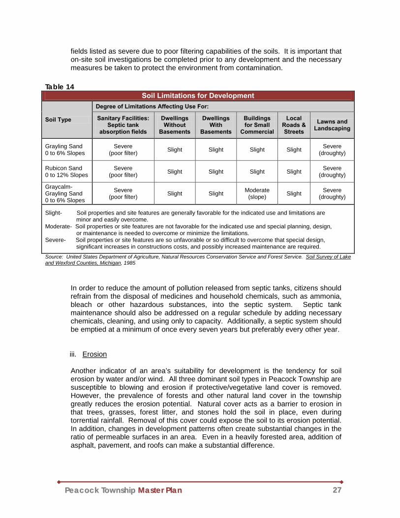
PPeeaaccoocckk TToowwnnsshhiipp MMaasstteerr PPllaann 2277
fields listed as severe due to poor filtering capabilities of the soils. It is important that on-site soil investigations be completed prior to any development and the necessary measures be taken to protect the environment from contamination.
In order to reduce the amount of pollution released from septic tanks, citizens should refrain from the disposal of medicines and household chemicals, such as ammonia, bleach or other hazardous substances, into the septic system. Septic tank maintenance should also be addressed on a regular schedule by adding necessary chemicals, cleaning, and using only to capacity. Additionally, a septic system should be emptied at a minimum of once every seven years but preferably every other year.
iii. Erosion
Another indicator of an area’s suitability for development is the tendency for soil erosion by water and/or wind. All three dominant soil types in Peacock Township are susceptible to blowing and erosion if protective/vegetative land cover is removed. However, the prevalence of forests and other natural land cover in the township greatly reduces the erosion potential. Natural cover acts as a barrier to erosion in that trees, grasses, forest litter, and stones hold the soil in place, even during torrential rainfall. Removal of this cover could expose the soil to its erosion potential. In addition, changes in development patterns often create substantial changes in the ratio of permeable surfaces in an area. Even in a heavily forested area, addition of asphalt, pavement, and roofs can make a substantial difference.
Table 14 Soil Limitations for Development
Soil Type
Degree of Limitations Affecting Use For:
Sanitary Facilities: Septic tank
absorption fields
Dwellings Without
Basements
Dwellings With
Basements
Buildings for Small
Commercial
Local Roads & Streets
Lawns and Landscaping
Grayling Sand 0 to 6% Slopes
Severe (poor filter) Slight Slight Slight Slight Severe
(droughty)
Rubicon Sand 0 to 12% Slopes
Severe (poor filter) Slight Slight Slight Slight Severe
(droughty)
Graycalm-Grayling Sand 0 to 6% Slopes
Severe (poor filter) Slight Slight Moderate
(slope) Slight Severe (droughty)
Slight- Soil properties and site features are generally favorable for the indicated use and limitations are minor and easily overcome. Moderate- Soil properties or site features are not favorable for the indicated use and special planning, design, or maintenance is needed to overcome or minimize the limitations. Severe- Soil properties or site features are so unfavorable or so difficult to overcome that special design, significant increases in constructions costs, and possibly increased maintenance are required.
Source: United States Department of Agriculture, Natural Resources Conservation Service and Forest Service. Soil Survey of Lake and Wexford Counties, Michigan, 1985
PPeeaaccoocckk TToowwnnsshhiipp MMaasstteerr PPllaann 2288
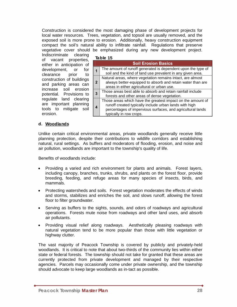
Construction is considered the most damaging phase of development projects for local water resources. Trees, vegetation, and topsoil are usually removed, and the exposed soil is more prone to erosion. Additionally, heavy construction equipment compact the soil’s natural ability to infiltrate rainfall. Regulations that preserve vegetative cover should be emphasized during any new development project. Indiscriminate clearing of vacant properties, either in anticipation of development, or for clearance prior to construction of buildings and parking areas can increase soil erosion potential. Provisions to regulate land clearing are important planning tools to mitigate soil erosion.
d. Woodlands
Unlike certain critical environmental areas, private woodlands generally receive little planning protection, despite their contributions to wildlife corridors and establishing natural, rural settings. As buffers and moderators of flooding, erosion, and noise and air pollution, woodlands are important to the township's quality of life.
Benefits of woodlands include:
• Providing a varied and rich environment for plants and animals. Forest layers,
including canopy, branches, trunks, shrubs, and plants on the forest floor, provide breeding, feeding, and refuge areas for many species of insects, birds, and mammals.
• Protecting watersheds and soils. Forest vegetation moderates the effects of winds and storms, stabilizes and enriches the soil, and slows runoff, allowing the forest floor to filter groundwater.
• Serving as buffers to the sights, sounds, and odors of roadways and agricultural operations. Forests mute noise from roadways and other land uses, and absorb air pollutants.
• Providing visual relief along roadways. Aesthetically pleasing roadways with natural vegetation tend to be more popular than those with little vegetation or highway clutter.
The vast majority of Peacock Township is covered by publicly and privately-held woodlands. It is critical to note that about two-thirds of the community lies within either state or federal forests. The township should not take for granted that these areas are currently protected from private development and managed by their respective agencies. Parcels may occasionally come under private ownership, and the township should advocate to keep large woodlands as in-tact as possible.
Table 15 Soil Erosion Basics
1 The amount of runoff generated is dependent upon the type of soil and the kind of land use prevalent in any given area.
2 Natural areas, where vegetation remains intact, are almost
always better-equipped to absorb and retain water than are areas in either agricultural or urban use.
3 Those areas best able to absorb and retain rainfall include forests and other areas of dense vegetation.
4 Those areas which have the greatest impact on the amount of
runoff created typically include urban lands with high percentages of impervious surfaces, and agricultural lands typically in row crops.

PPeeaaccoocckk TToowwnnsshhiipp MMaasstteerr PPllaann 2299
e. Greenways
Greenways are dedicated spaces utilized for conservation and enhancement of natural and cultural resources. Greenways may also provide recreational opportunities, aesthetic benefits, and linkages for users between open space and recreational facilities. Greenways can also:
• Tie public land components together to form a cohesive land assembly for recreation and open space;
• Emphasize cohabitation with the natural environment;
• Preserve an attractive environment for residents and visitors;
• Allow uninterrupted and safe pedestrian movement between parks throughout the community;
• Protect areas inappropriate for development such as flood plains, wetlands, and steep slopes;
• Promote recreational tourism and enhance the local economy;
• Foster a greater awareness and appreciation of historic and cultural heritage;
• Provide people with a resource-based outdoor recreational opportunity and experience;
• Promote a sense of place and regional identity;
• Provide an effective and sensible growth management tool; and
• Enhance property values.
Greenways are most effective when large natural areas remain sparsely developed. Some interruptions are inevitable because of existing roadways interposed between undeveloped spaces. In general and at the very least, greenways should follow natural drainage corridors since the land offers more habitat value, is important for natural storm water drainage, and is generally more difficult to develop. Peacock Township contains a number of naturally-occurring greenways along water features and throughout the Manistee National Forest and Pere Marquette State Forest. This natural landscape is highly valued by the community as a source of recreation and a major contributor to its rural identity.
f. Non-Point Source Pollution
Non-point source pollution poses one of the greatest threats to surface and groundwater. Rather than occurring from one major source, like a sewage treatment plant or industrial use, non-point source pollution results from rainfall or snowmelt moving over and through the ground. As this runoff moves, it picks up soil and human pollutants, and deposits them into lakes, rivers, wetlands, ponds, and groundwater. In Peacock Township, possible sources of non-point contamination include a combination of lawn chemicals, soil erosion, and stormwater runoff. Techniques that
PPeeaaccoocckk TToowwnnsshhiipp MMaasstteerr PPllaann 3300
significantly protect water quality from these threats include limiting impervious surfaces and protecting or providing vegetated buffers along existing waterways.
Stormwater flowing over the land carries with it pollutants like oils and gas from motor vehicles, fertilizers and pesticides, and washed away soil particles. Pollutants degrade surface water quality and choke streams and rivers with sediment. Sediment is created when soils are washed from the land’s surface into water bodies. Sediment can smother fish beds and disrupt aquatic insects and other life that serve as food for larger aquatic life. The impact of sediment moves up the food chain and fundamentally changes the entire ecosystem. There are many examples of coldwater trout streams in Michigan that became choked with sediment as a result of stormwater runoff and erosion. Coldwater streams can also be degraded when removal of shoreline vegetation exposes the water to greater amounts of sunlight and warms the water. This can ultimately eliminate prized coldwater species like trout, and leave behind tough species like carp, suckers and bloodworms. Stormwater can be managed in a fashion which will not substantially alter natural drainage flows, especially as it relates to the quantity of runoff (from rainfall) versus infiltration within a watershed. As more development takes place, either on large projects or on small home sites, the land loses its ability to hold soil in place. Natural vegetative cover is replaced by roof tops, roadways, parking lots, and other impervious surfaces. The increase in impervious area will greatly increase the rate and volume of runoff and decrease water infiltration into the ground. The township should ensure that post-development rates of runoff do not exceed pre-development rates. This is generally accomplished by detaining or retaining stormwater to control the rate at which runoff is allowed to leave the development site. If stormwater facilities are properly designed, significant water quality benefits can also be realized. Various stormwater management alternatives can be employed to accomplish these objectives. In rural areas, it is important that stormwater management methods blend with the environment. For example, rather than a stark detention pond that looks artificial, smaller retention areas with natural vegetation (rather than mown riverbanks) blend with the rural environment and can serve as new habitat. A series of smaller detentions areas is generally a better approach than one large area. Improper drainage flows can create erosion and sedimentation problems, resulting in the loss of fertile topsoil, filling of lakes and streams, increased flooding, damage to aquatic habitat and animals, and structural damage to buildings and roads. Soil erosion and sedimentation controls are needed to ensure that development activities do not permit soil to be transported from the site to existing or planned drainage systems. A variety of methods exist to assist in achieving this objective. The most visible of these are silt fences which may be seen surrounding many development sites. Where the potential for erosion is high, it is critical not only that controls be in place prior to the start of development, but that such controls be maintained throughout the development process. The purpose of Part 91, Soil Erosion and Sedimentation Control, of the NREPA (P.A. 451 of 1994, as amended) is to control soil erosion and to protect the waters of the state from sedimentation. This law requires that a permit be obtained for all earth changing activities that disturb one or more acres of land or is within 500 feet of a lake

PPeeaaccoocckk TToowwnnsshhiipp MMaasstteerr PPllaann 3311
or stream. To obtain the permit, a soil erosion and sedimentation control plan must be submitted that effectively reduces soil erosion and sedimentation and identifies factors that may contribute to soil erosion and sedimentation.
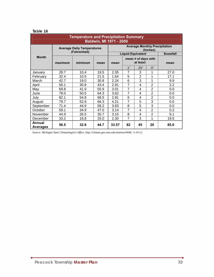
g. Climate
Peacock Township is located in an area of the United States which experiences unique and diverse climatic conditions due to its location, about 25 miles east of Lake Michigan. Table 16 shows notable climatic data from the 30-year period from 1971-2000 observed in the nearby Village of Baldwin. It is assumed that the township and the village experience comparable climatic conditions since they have a similar proximity to Lake Michigan. The lake has a moderating effect on climate, making summers cooler and winters milder on the western side of Michigan’s Lower Peninsula than in other areas of the state. The proximity of Lake Michigan also causes a meteorological phenomenon called lake effect snow. During the winter months, the relatively warm waters of the lake provide moisture for weather fronts as they cross over from Wisconsin. When these fronts reach the cooler land of Michigan, the moisture condenses and falls as snow. Lake effect snows can be serious and hazardous weather events; however, their actual duration and severity can vary greatly. Winter weather, often in the form of lake effect snow, will occasionally affect Peacock Township with treacherous driving conditions, cost of snow removal, and infrastructure failures in the winter months. Rural and secondary roads often experience the worst driving conditions in the winter because they are the last to be cleared and salted.
In addition to severe winter weather, Peacock Township may experience severe thunderstorms and high wind. According to FEMA’s “Wind Zones in the United States” map, Peacock is located on the northern fringe of Zone IV, where winds of up to 250 miles per hour are possible. These winds may be produced by strong weather systems, tornadoes, or thunderstorms. In addition, the NOAA estimates that the township should experience around 30-40 thunderstorm days per year. Thunderstorms are most likely to occur during the warm months between spring and fall, but are possible any time of the year.
Map 7 Thunderstorm Days per Year
Source: NOAA, http://www.srh.noaa.gov/jetstream//tstorms/tstorms_intro.htm
PPeeaaccoocckk TToowwnnsshhiipp MMaasstteerr PPllaann 3322
Table 16 Temperature and Precipitation Summary
Baldwin, MI 1971 - 2000
Month
Average Daily Temperatures (Fahrenheit)
Average Monthly Precipitation (Inches)
Liquid Equivalent Snowfall
maximum minimum mean mean mean # of days with
at least: mean .1” .25” .5”
January 28.7 10.4 19.5 2.35 7 3 1 27.0 February 32.4 10.5 21.5 1.64 5 2 1 17.1 March 42.7 19.0 30.8 2.24 6 3 1 9.9 April 56.1 30.8 43.4 2.91 7 4 2 2.2 May 69.8 41.9 55.9 3.01 7 4 2 0.0 June 78.0 50.5 64.3 3.62 7 4 2 0.0 July 82.1 54.8 68.5 2.81 6 4 2 0.0 August 79.7 52.9 66.3 4.21 7 5 3 0.0 September 71.4 44.9 58.2 3.93 8 5 3 0.0 October 59.1 34.9 47.0 3.14 7 4 2 0.2 November 44.9 26.5 35.7 3.15 8 4 2 9.1 December 33.2 16.8 25.0 2.30 7 3 1 19.5 Annual Averages 56.5 32.8 44.7 33.57 82 45 20 85.0
Source: Michigan State Climatologist's Office. http://climate.geo.msu.edu/stations/0446/. 5-19-11.

PPeeaaccoocckk TToowwnnsshhiipp MMaasstteerr PPllaann 3333
J. Existing Land Use and Cover
Peacock Township’s land use consists primarily of widely scattered residential dwellings. More concentrated residential development is limited and most common near Wolf Lake. Commercial development within the township is limited as well and generally located along state highway M-37 near Wolf Lake. With a large portion of land being owned by the U.S. Forest Service and the State, rendering many areas unbuildable, it is reasonable to expect that development will continue to remain limited in the near future. Although Peacock’s population increased over 40% between 1990 and 2010, its character has remained rural. There have been no major changes or disruptions to the township’s land uses or land cover during that period. Peacock’s rural nature is illustrated on Map 10 – Land Cover circa 1992, which shows that over 90% of the township is comprised of vegetated land cover. While most of the land cover is forested, the second most common type of land cover is wetland. Table 17 reports the distribution of land covers across Peacock according to this data. Although the land cover data presented in this section is rather outdated, it remains useful for identifying land cover patterns. The information was derived from the National Land Cover Dataset (NLCD) published by the United States Geological Survey (USGS) in 1999. The data represents conditions in the early 1990’s and is displayed on the map by 30-meter pixel detail. The USGS states that this data is most accurate when viewed at the state or multi-state level (rather than the township level). Therefore, it is important to note that this map is very general and should not be consulted for site-specific land cover analysis. NLCD Land Cover definitions are listed in the table below.
Table 18 NLCD Land Cover Classification Definitions
Developed Areas characterized by high percentage (approximately 30% or greater) of constructed material (e.g. asphalt, concrete, buildings, etc.).
Herbaceous Upland Upland areas characterized by natural or semi-natural herbaceous vegetation; herbaceous vegetation accounts for 75-100% of the cover.
Herbaceous Planted/Cultivated
Areas characterized by herbaceous vegetation that has been planted or is intensively managed for the production of food, feed, or fiber; or is maintained in developed settings for specific purposes. Herbaceous vegetation accounts for 75-100% of the cover.
Vegetated/ Natural Forest Upland
Areas characterized by tree cover (natural or semi-natural woody vegetation, generally greater than 6 meters tall); Tree canopy accounts for 25-100% of the cover.
Wetlands Areas where the soil or substrate is periodically saturated with or covered with water.
Source: National Land Cover Dataset (USGS, 1992)
Table 17 Land Cover Distribution
circa 1992 Land Cover Category %
Development 0.18% Herbaceous Upland 3.21% Planted/Cultivated 0.02%
Forest 86.72% Wetland 7.36% Water 2.51%
Statistics derived from NLCD (USGS, 1992).
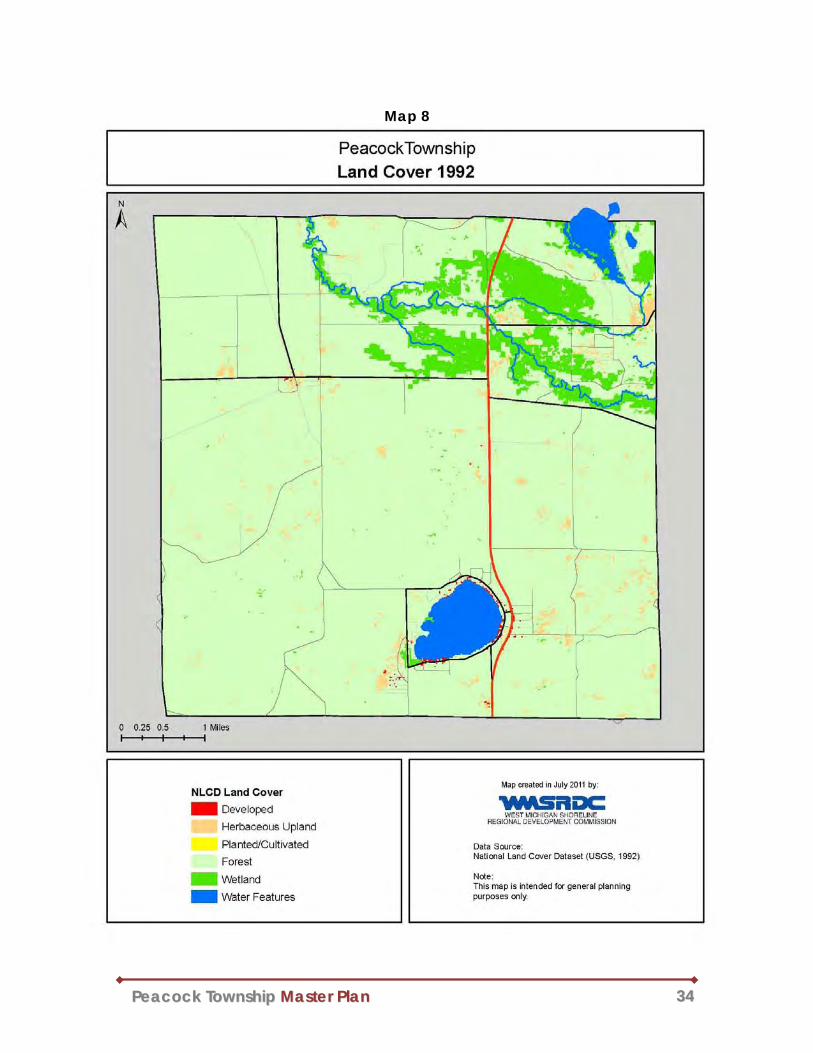
PPeeaaccoocckk TToowwnnsshhiipp MMaasstteerr PPllaann 3344
Map 8

PPeeaaccoocckk TToowwnnsshhiipp MMaasstteerr PPllaann 3355
Chapter 3: Goals and Objectives One must obtain a thorough understanding of a community in order to establish an appropriate development strategy for its future. The previous chapters of this document describe the township’s history, demographics, infrastructure, and physical geography. However, one critical component to the analysis of Peacock Township has yet to be addressed: public opinion. It is described in the “Township Visions” section below. The information presented therein is then synthesized with the information from previous chapters of this document to form the final section of this chapter, “Goals and Objectives.”
A. Township Visions
The needs and desires of the citizens must be carefully considered in order to develop an appropriate and effective master plan. To help develop the visions revealed in this chapter, the following efforts were made to seek public input from township residents. The Peacock Township Planning Commission, with the assistance of the West Michigan Shoreline Regional Development Commission (WMSRDC), held a special public hearing at the Township Hall on Tuesday, June 14, 2011 to gather input from interested citizens for the Peacock Township Master Plan. Township officials published a notice of this hearing in the May 26, 2011 edition of the Lake County Star. The meeting included a discussion of the planning process, a visioning exercise, and open discussion of various issues within Peacock Township. The June meeting was well attended and involved residents from many areas of the township. Comments and opinions captured at the meeting strongly influenced the Goals and Objectives outlined in the following chapter. A summary of the comments received is included in Appendix B of this document. The Goals and Objectives were also influenced by the Land Use Plan chapter contained within the Peacock Township’s Zoning Ordinance. Although the Ordinance is frequently updated (it was most recently amended in 2011), it is unknown when that section was originally written.
B. Goals and Objectives The Goals and Objectives are intended to usher Peacock Township to a desirable condition within the next 20 to 25 years. They are intentionally general but are all attainable through a proactive and collaborative community effort. The objectives tend to be more specific and may be viewed as milestones used in the process to achieve the broader goals. The Goals and Objectives are organized, in no significant order, into four subject areas: Land Use & Development, Recreation & Environment, Local Economy, and Community. Maintenance of the community’s rural character and protection of its natural resources are two overriding themes within the Goals and Objectives. It will be important for the township to periodically review them to maintain a long-term vision for the community and remain proactive towards land use planning.

PPeeaaccoocckk TToowwnnsshhiipp MMaasstteerr PPllaann 3366
GOAL: Make a strong commitment to be proactive regarding land use and
development issues within the township in order to protect and maintain the community’s rural, natural, and residential character.
Objectives:
● Discourage overdevelopment and land use conflicts, especially in and around existing neighborhoods.
● When considering locations for future development, give special attention to protection of natural features (such as wetlands, slopes, woodlots, water features, etc.) and open space preservation.
● Identify and regulate land uses and development practices that have the potential to contaminate surface water and groundwater.
● Encourage developments that preserve open space and allow natural corridors to remain intact.
● Limit the amount of impervious surface in new developments by placing limits on the amount of a site that can be covered by impervious surfaces, and providing buffers between paved areas and wetlands or surface waters.
GOAL: Strive to maintain quality recreational opportunities for residents and
visitors, while acting as a steward of natural resources. Objectives:
• Maintain public land and access to natural resources.
• Augment recreational facilities, as needed, to adequately serve the needs of township residents.
• Take steps to inform and educate residents and visitors of the abundant natural resources and the need to protect and preserve these important areas.
• Coordinate with neighboring communities, local organizations, Michigan DNR, and the U.S. Forest Service to provide consistency in recreational opportunities and environmental protection.
• Protect surface and groundwater quality, and encourage development practices that maintain the integrity of these features.
Land Use & Development
Recreation & Environment

PPeeaaccoocckk TToowwnnsshhiipp MMaasstteerr PPllaann 3377
GOAL: Embrace and support the township’s identity as an outdoor recreation
destination.
Objectives:
• Actively encourage a level of economic activity that meets the needs of local residents and visitors.
• Work closely with county and regional economic development organizations to promote and support businesses within the township, as well as throughout Lake County and West Michigan.
GOAL: Preserve the rural character of Peacock Township and maintain the high
quality of life enjoyed by its residents.
Objectives: ● Encourage and provide avenues for communication between township
residents, associations, and officials.
● Make an effort to increase public participation within the township.
● Foster a sense of community by providing opportunities for residents to volunteer.
● Sustain a good working relationship with county and State police to provide adequate public safety.
● Work with State and county road agencies to improve pedestrian safety in the township, and especially in developed areas around Wolf Lake.
● Make a commitment to minimize and address blight within the township.
Local Economy
Community
PPeeaaccoocckk TToowwnnsshhiipp MMaasstteerr PPllaann 3388
Chapter 4: Development Strategy Development concepts serve as a bridge between the township’s Goals and Objectives, and its plan for future land use. They include broad explanations of basic assumptions and supporting ideas that were used to develop the Future Land Use Districts and the Future Land Use Map revealed in Chapter 5. Township leaders should keep the following concepts in mind when making land use decisions.
A. Basic Assumptions
Based on the Community Profile (Chapter 2) and the Goals and Objectives (Chapter 3), three key assumptions about growth and development of Peacock Township can be extracted:
1) The population of the township has continually increased from 144 in 1970, to 496 in 2010. Growth is projected to continue over the next 20 years.
2) As the township continues to grow, preservation of the community’s character and natural resources will be paramount.
3) Community awareness of natural resources, and active involvement in resource protection, will be critical to the preservation of the valued state of Peacock Township.
B. Growth Management
Growth, in terms of population and development, affects land use patterns and the character of a community. Open spaces, lack of traffic congestion, and natural settings found in low residential density townships often entice people to move to such areas. However as growth occurs, the very things that were enticements can be lost. The results of growth can be expensive (cost of infrastructure, school facilities, public safety, etc.) and potentially harmful to natural resources and the environment. Residential development pressure will likely increase as Peacock Township continues to grow, and especially if public forest lands are sold for natural resources or private development. Orderly development, which provides for the protection of environmental resources as well as the character of the township, should be promoted through responsible growth management strategies and techniques. According to the Michigan Department of Natural Resources in 1995, growth management refers to the systematic attempt by a community to guide the type, rate, location, timing, public cost of, and often the quality and character of land redevelopment. In other words, growth management seeks to accommodate growth rationally, not to prevent or limit it. This concept is supported by the Peacock Township Planning Commission as a means of managing future development.
C. Settlement Patterns The manner in which a township develops has a tremendous impact upon its character, opportunities for recreation, and etc. For the most part, land is a finite resource, and must therefore be used wisely. Once land is fully developed it is nearly impossible to
PPeeaaccoocckk TToowwnnsshhiipp MMaasstteerr PPllaann 3399
revert it back to its original state. Therefore, conserving open spaces at the onset of development is imperative. With so much land that is either undeveloped or under public ownership, Peacock Township is in a unique position to plan for conservation. The full development of entire land parcels may result in excessively large residential lots. A “one size fits all” zoning regulation dictated by minimum lot sizes can result in a checkerboard layout of large, nearly identical lots. A community concerned with conserving open spaces must exercise caution with this method of settlement which may lead to the unnecessary consumption of significant natural areas. Fortunately this is not the only means of managing development. Full density can be achieved on a much smaller portion of land by allowing flexible standards for lot size and frontage. This leaves the balance in permanent conservation. The open-space subdivision design approach, as well as other land preservation methods, encourages the conservation of more than just surface water, wetlands, and steep slopes. They can allow for the protections of sensitive or unique natural areas, historic buildings, scenic vistas, or anything else a community deems worthy of preservation. Costs of development and infrastructure will also be minimized by reducing the amount of land utilized by the development.

PPeeaaccoocckk TToowwnnsshhiipp MMaasstteerr PPllaann 4400
Chapter 5: Future Land Use A future land use map requires a synthesis of all the information included in a master plan and results in a map that generally depicts the various types of recommended land uses and their approximate locations in the community. The map is accompanied by text explaining the “districts” or “categories” used on the map. These categories describe the character of land uses as well as their relation, if any, to the zoning districts dictated by the Peacock Township Zoning Ordinance. A master plan and a zoning ordinance are separate, yet closely related, and often mistaken for one-another. Generally speaking, the master plan and future land use map are intended to reflect the future ambitions of the community, while a zoning ordinance provides the means to arrive at that point. The future land use map is intended to serve as a guide for land use decisions over a longer period of time, while the zoning map is a mechanism for shaping immediate development decisions. A zoning ordinance is the legal arm of a master plan. It regulates land use and is the most frequently used and effective regulatory tool to implement a master plan. The primary land use regulation tool is a community’s ability to alter and adjust regulations spelled out in the zoning ordinance. The master plan and future land use map can be utilized to guide and encourage what and where zoning changes will occur. For example, rezoning requests are often required to be consistent with the master plan’s designations, which are consistent with the community’s desires for the future. The word “district” is often used in both kinds of documents; however, the term must be used carefully. On one hand, using similar terms for the various land use designations is one way to demonstrate the relationship between the two documents, and it helps to avoid confusion and translation difficulties. On the other hand, it is imperative to acknowledge that future land use map and a zoning map districts are not necessarily equal. For example, the use of a term such as “cluster housing” in a future land use map does not necessarily translate into specific numbers in terms of lot sizes and other elements of zoning. Zoning districts should be specific and precise for legal reasons, while future land use categories should remain general to allow for future flexibility and interpretation.
Future Land Use Categories
Seven general future land use categories have been identified for the township. They were laid out as a result of analyses of current land uses and zoning; physical and environmental suitability; and compatibility with goals and objectives identified in the plan. These land uses include:
→ Agricultural → Commercial → Industrial → Low Density Residential → Medium Density Residential → Mobile Home Residential → Waterfront Protection

PPeeaaccoocckk TToowwnnsshhiipp MMaasstteerr PPllaann 4411
Agricultural The Agricultural category is intended to include open areas where farming, forestry operations, outdoor recreation, and other such rural-type activities exist and should be preserved or encouraged. These areas are spread throughout the Township recognizing that the main attractions for living in as well as commercial activity are the aesthetic and recreational opportunities these areas provide. Development in these areas should be limited so that they not be destroyed. Areas designated for agricultural use account for about one-third of the future land use map, making it the second most common use in the township. In addition, a significant majority of land in this category is state or federal forestland, which fits well with the description of this category. The Agricultural future land use category closely corresponds with the “AG” Agricultural District described in the Peacock Township Zoning Ordinance.
Commercial
Provide retail sale and commercial services for the residents and tourists as well as to encourage general commercial activity within the township. In order to preserve the existing character of the township, new commercial developments should be compatible and harmonious with adjacent surroundings. The preservation of environmentally sensitive areas, important open space, and natural corridors is strongly encouraged. Areas designated for commercial use are limited to the M-37 corridor. The Commercial future land use category closely corresponds with the “C-1” Commercial District described in the Peacock Township Zoning Ordinance.
Industrial
The Industrial category is intended to allow for industrial uses such as research and development; wholesale and warehouse activities; and manufacturing, fabricating, and assembling operations. Ideal activities in this area would exist without causing nuisance to nearby properties or the general public, and have minimal environmental impact. It is encouraged that these areas have access to major transportation routes and municipal water and wastewater services. The area designated for industrial use is located along the southern border of the township near M-37. This location is near comparable land uses in Webber Township to the south. Due to a lack of water and wastewater infrastructure, Peacock Township does not have intentions of promoting or encouraging heavy industrial development within this area. The Industrial future land use category closely corresponds with the “I-1” Industrial District described in the Peacock Township Zoning Ordinance.

PPeeaaccoocckk TToowwnnsshhiipp MMaasstteerr PPllaann 4422
Low Density Residential The Low Density Residential category is intended to be the most restrictive of the residential land uses within the township. It is intended to encourage an environment of predominately low-density single family dwellings and a minimum amount of other residentially-related uses. The area designated for low density residential use is located in the Wolf Lake area. If development of the area around Syers and Ingerman lakes increases, it is recommended that those areas be considered for inclusion within this category to limit the density of development and to protect the lakes. The Low Density Residential future land use category closely corresponds with the “R1” Residence District described in the Peacock Township Zoning Ordinance.
Medium Density Residential
The Medium Density Residential category is intended to allow for the greatest density of the residential land uses within the township. It includes areas that have been considered for agricultural land uses in the past, but have since been changed to accommodate and direct potential residential development. It is encouraged that larger residential developments and any concentrations of multi-family dwellings have access to municipal or shared water and wastewater services.
Areas designated for medium density residential uses are primarily located across the northern tier of the township and on the outskirts of the Wolf Lake area. This category covers about 16 square miles of the township, making it the most common future land use category on the future land use map. However, because of federal and state land ownership in the township, less than half of the category is privately owned. The Medium Density Residential future land use category closely corresponds with the “R2” Residence District described in the Peacock Township Zoning Ordinance.
Mobile Home Residential
In response to an increasing prevalence of mobile homes in Peacock Township, the Mobile Home Residential category aims to identify locations that are best-suited to accommodate mobile homes and mobile home parks. It is not intended for these areas to be fully developed into mobile home parks. Rather, these areas should have a similar character to that of the Medium Density Residential areas. It is encouraged that any large, concentrated developments have access to municipal or shared water and wastewater services. The three general areas designated for the location of mobile homes are located in the center of the township and on the eastern and western borders. The Mobile Home Residential future land use category closely corresponds with the “R3” Residence District described in the Peacock Township Zoning Ordinance.

PPeeaaccoocckk TToowwnnsshhiipp MMaasstteerr PPllaann 4433
Waterfront Preservation One of the most effective means of preventing water quality degradation is through protection of the water's edge with a natural species vegetated buffer. The Waterfront Protection category is primarily intended to encourage protection of the shore land along lakes and rivers, and to ensure that new development is compatible with the water quality and carrying capacity of the water resource. This category does not seek to prohibit development along water features. Rather, new development in these areas should have low-density residential or recreational characteristics. Sensitive site development techniques, such as preserving existing vegetation, should be encouraged to help control erosion and protect water quality. Ideally, this category should apply to all shore lands surrounding surface water features. It is represented on the Future Land Use map by a 200-foot buffer around four significant water features in Peacock Township: Little Manistee River and Ingerman, Syers, and Wolf lakes. These areas should be referenced as a general guide, as its boundaries are general in nature and not intended to establish finite boundaries. The Waterfront Preservation future land use category does not correspond to any districts specified within the Peacock Township Zoning Ordinance. In time, it may be beneficial to add a Waterfront Protection Overlay to provide additional development standards to preserve surface and groundwater quality, promote safety, and to preserve the quality of recreational use of all waters in the township.

PPeeaaccoocckk TToowwnnsshhiipp MMaasstteerr PPllaann 4444
Map 9

PPeeaaccoocckk TToowwnnsshhiipp MMaasstteerr PPllaann 4455
Chapter 6: Implementation Tools & Techniques
Implementation is the ultimate goal of planning. Implementing the ideas generated through the planning process is the culmination of analysis, goal setting, and interaction activities that occur during the creation of a master plan. This portion of the master plan is designed to guide the community in taking the actions to help achieve its goals and objectives. This plan is intended to be a working document that provides township decision makers with information on the goals desired and communicated by the community. It should be consulted whenever policy issues arise, especially those relating to land use. Additionally, appropriate adjustments should be made to the plan when the visions of the township change or advance. Successful implementation requires a dedicated effort on the part of the Peacock Township Planning Commission, Township Board, and the community at large. It is essential that each member of the Planning Commission and Township Board understands the master plan, knows his/her own role as it relates to the plan, and promotes implementation of the plan. The Goals and Objectives of the Peacock Township Master Plan can be implemented through usage of the tools and techniques described in this chapter. The list of tools and techniques is certainly not exhaustive, and some items are more applicable to the township than others. Many of the tools and techniques have multiple uses, and can be employed creatively by the township to achieve its goals and objectives.
Zoning Ordinance
The purpose of zoning is to assist in orderly development and growth, to protect property values and investments, and to promote the health, safety, and general welfare of citizens. The Peacock Township Zoning Ordinance is perhaps the most important tool available to implement the land use and development concepts of the Peacock Township Master Plan. Following the adoption of this plan, the township should amend its Zoning Ordinance as appropriate to ensure consistency between the two documents.
Evaluation of Land Use Changes
Changing the land use or zoning designation for any property can have far-reaching consequences; physically, environmentally, financially, and legally. Therefore, careful evaluation of proposed rezoning is essential. As with any land use decision, the use of standards is essential to reaching fair and consistent decisions. The following evaluation measures are included to assist township officials when rezoning or future land use changes are contemplated. The zoning district intents and specified rezoning criteria provided in the zoning ordinance must also be considered during the evaluation process. Standard 1 – Consistency with the Community Vision and Plan Strategies
If conditions (such as economic, demographic, environmental, etc.) upon which the master plan was developed have changed significantly since it was adopted, the

PPeeaaccoocckk TToowwnnsshhiipp MMaasstteerr PPllaann 4466
Planning Commission and Township Board should incorporate these factors into their deliberations to ensure that the plan is current. Particular attention should be paid to the Goals and Objectives to ensure that the township’s vision remains valid, and that any proposed rezoning or land use change does not impair their intent. Standard 2 – Compatibility with adjacent uses and districts
All land uses allowed in a proposed zoning district should be compatible with the conditions present on the site and in the immediate vicinity of the site especially in terms of density, character, traffic, aesthetics, and property values. Standard 3 – Capability of being used as already zoned
It is the right of every property owner to receive a reasonable return on the investment placed on property. This does not mean that zoning is a slave to the "highest and best use" (which is not a zoning, but rather a real estate term). It does mean that there should be a reasonable use available within the zone district. But if the property is capable of being used as zoned, there should be a compelling reason to change the zoning. Such reasons may be related to the first two standards of consistency and compatibility. Site plans should not be considered as part of a rezoning request. The Planning Commission and/or Township Board is encouraged to not be swayed by what is proposed by the petitioner. Instead, the township will make a specific finding that ALL of the uses permitted in the proposed district are appropriate for the site and area, not just the one shown on a proposed site plan. Standard 4 – It is critical that the Master Plan be read in its entirety
Rather than attempting to isolate individual statements that may appear to support one position or another regarding the future land use in the township, the Planning Commission must consider the intent of the master plan as a whole. This requires an intimate knowledge of the plan to ensure that all considerations are included in the evaluation of any change.
Land Division Act
Townships are authorized to regulate and control the subdivision of land within their jurisdictions pursuant to Public Act 591 of 1996, the Land Division Act (formerly known as P.A. 288 of 1967, the Subdivision Control Act). Amended in 1997, this act gave a township with a land division ordinance more control over how land could be divided and lessened state controls. The act governed the division of existing parcels, called “parent parcels,” as identified by the state.
A township can have an important voice in the design and layout of subdivisions and can set uniform standards for streets and roads, utilities, and other improvements with the utilization of a local land division control ordinance. The land division ordinance can reference all other township ordinances and require conformance with them. Conformance with the zoning ordinance and the insertion of land division design standards while updating the ordinance offers control over density.

PPeeaaccoocckk TToowwnnsshhiipp MMaasstteerr PPllaann 4477
Planned Unit Development (PUD) The planned unit development concept is utilized by many communities to encourage innovative and imaginative project design. As a development type, it permits flexibility in site design and usage. It allows buildings to be clustered by mixing types, or by combining housing with ancillary uses such as neighborhood shopping. It allows for better design and arrangement of open space and the retention of such natural features as forests, slope, and floodplains. As a regulatory tool, it allows variation in many of the traditional controls related to density, setback, use, and open space.
Cluster Development Cluster development is a residential site design and zoning technique used to protect natural, cultural, or recreational features of the landscape while allowing new development. The basic idea is to cluster new development on one portion of a property, while leaving a large tract of environmentally sensitive or scenic land intact on the remainder of the parcel. If used carefully, this technique can significantly lower the impact on the natural landscape and minimize the costs of providing public services to new homes since they are located in proximity to each other. While similar to PUD development, Cluster development should not be confused with planned unit development (PUD). Cluster development places a greater emphasis on protecting open space and typically applies only to residential units. PUDs, on the other hand, focus on infrastructure reduction and often allow compatible commercial development (e.g., convenience stores, office, etc.) to be included in the overall development.
Open Space Preservation A variation on the PUD theme is an Open Space Preservation district. In this type of district, or in a residential district with this feature, developers are encouraged to set aside open space in perpetuity in exchange for flexibility on the part of the township with respect to zoning requirements. Open space conservation is important because open space needs to be planned and provided for prior to complete development occurring.
Key characteristics of an Open Space Preservation District/Overlay, when combined with elements of the PUD concept, include:
● Flexibility in the design of a development.
● Lot size restrictions in traditional zoning are converted to density limitations where the unit of measurement is the entire project, not the individual lot.
● Allowance for slightly greater density than normal zoning, in most cases, as an incentive.
● Buffering/open space in the development is in exchange for flexibility on the part of the township, so the alternative (i.e. traditional zoning) must be fairly rigid, more restrictive, and strictly enforced.

PPeeaaccoocckk TToowwnnsshhiipp MMaasstteerr PPllaann 4488
● The developer saves money through lower up-front costs for infrastructure, and tends to make more profit through higher initial sales price and greater sales volume.
Open Space Zoning allows the developer to have some additional units to market, in exchange for the promise to set aside a portion of the development as open space in perpetuity.
Growth Management As mentioned in Chapter 4, growth management refers to the systematic attempt by a community to guide the type, rate, location, timing, public cost of, and often the quality and character of land re-development. Growth management must be, first and foremost, well integrated into the planning and zoning process. As an overview, there are several possible avenues to explore when considering a growth management strategy. Among them are:
Purchase of Development Rights In this scenario, the township directly remunerates the land owner in return for exclusive rights to develop the property as the township sees fit or to preserve it. The rights may also be sold to yet another property owner who can (or will) develop the land as the township wishes. The land owner participates voluntarily, still owns the land, and can use or sell the land for specified purposes, such as farming or hunting.
Once a Purchase of Development Rights agreement is made, a permanent deed restriction is placed on the property which limits the type of development that may take place on the land. A legally binding guarantee is thus achieved to ensure that the parcel will remain as it is or be developed only as wished. The deed restriction can also be referred to as a conservation easement. Conservation Easements The Farmland and Open Space Preservation Act of 1974 provides for dedication of a conservation easement to a public entity while the Conservation and Historic Preservation Easement Act of 1980 gives a third party, such as a land trust, the right to receive and the resulting responsibility to enforce an easement. Conservation easements are voluntary legal agreements between landowners and a land conservancy or government agency and are distinct property rights that may be sold or donated separately from other rights. Conservation easements are effective for preserving sensitive lands, providing public access along rivers or greenways, and allowing property owners to consider land stewardship while they continue to live on their land. They permanently limit development of the property in order to protect the conservation values of the land. The landowner continues to bear all costs and liabilities related to ownership and maintenance of the property. The relationship between Purchase of Development Rights and conservation easements is close and the terms are often used interchangeably. However, conservation easements can be both sold or donated. When a land owner sells the development rights for less than their full value, it is called a “bargain sale.” Bargain

PPeeaaccoocckk TToowwnnsshhiipp MMaasstteerr PPllaann 4499
sales and donations can reduce income, inheritance, and property taxes while providing cash for needed purposes when meeting the necessary requirements. Transfer of Development Rights Although not authorized by statue for use between jurisdictions in Michigan, this technique has been used successfully elsewhere. It is a variation on the above, except a trade is made between two or more parcels. It essentially is a method for protecting land by transferring the “right to develop” from one area (sending) and giving it to another area (receiving). A consensus must be reached on where the public wishes to preserve low density or open space and where it will allow for increases in development densities. “Receiving” areas generally have streets, public water and sewer, and other improvements or the improvements are such that they can be extended a short distance without extensive cost. The costs of purchasing the easements are recovered from the developers who receive building “bonuses” according to the values agreed upon. As with Purchase of Development Rights, the owner of the preserved site participates voluntarily and retains existing use rights while receiving compensation for the development value of the land. Concurrency This is a situation in which the township ties development ( i.e. density and type) to established bench marks regarding public service (i.e. water, sewer, roadway capacity, police, fire, educational and others) to control development. No development can occur in a given area until the benchmarks are met, either by the township or the developer. This method also requires a carefully laid out capital improvements plan (CIP) to be fully effective. CIP is described below. Development Agreements This would operate much like a contract/site plan review process combined. It would cover a fixed period in time, and would identify specific elements of development covered. It would offer assurances for both sides that planning could take place and there would be no changing of the rules in the middle of the game. Regional Impact Coordination In a larger sense, this concept amounts to a specific agreement to involve other jurisdictions in any development which has a “regional impact”. One way to implement such coordination is through the establishment of a joint planning commission (JPC), as enabled by the State of Michigan’s Joint Municipal Planning Act PA 226 of 2003. The State of Michigan has taken another step by making it mandatory that amendments to a community’s master plan be submitted, for review and comment, to all bordering jurisdictions, the acting regional planning commission, and ultimately the county. While presently these comments have no regulatory implications, this legislation is the first step in working towards a collaborative effort amongst bordering municipalities encouraging similar land uses on adjacent parcels.
Capital Improvements Program
A capital improvements program (CIP) is a fiscal plan outlining the means for the township to finance selected projects requiring capital, either on a short-term or long-

PPeeaaccoocckk TToowwnnsshhiipp MMaasstteerr PPllaann 5500
range basis. The CIP thus sets priorities for future development. Projects typically included are public facilities such as township halls and parks, land improvements, roads, bridges, acquisitions, utilities, planning projects, etc.
Dedicated Millage A dedicated millage can be used to generate revenues for a specific purpose and, in so doing, can implement recommendations of the Master Plan. For example, a dedicated millage could be used to establish a land acquisition fund, a recreational path fund, or a conservation easement program. All of these would be useful tools for promoting open space preservation. Although acquisition of land by a governmental unit provides the greatest level of land use control, it is also the most expensive. In addition to acquisition costs, purchases remove property from the tax rolls and decreases property tax revenues.
Land Conservancy While property owners can voluntarily donate or sell land or easements in the interest of conserving natural resources or natural features, and perhaps qualify for income, estate and property tax benefits, private land trusts can facilitate a resource protection program by use of a variety of land acquisition and conservation techniques. For instance, the Land Conservancy of West Michigan (LCWM) “protects lands that contribute to the distinctive character and quality of life in West Michigan; lands that are important for their values as habitat for native plants and animals, as centers for study and quiet recreation, and as elements of scenic beauty and rural character. LCWM offers positive, non-regulatory solutions to disappearing open space that benefit landowners and local communities.” LCWM acquires natural land through donation or “bargain sale” purchase of high priority land for the purpose of creating nature preserves that are open to the public. It also assists with conservation easements and works with developers to construct easements for open space design. Finally, LCWM assists local governments with identifying important natural areas, preserving lands, creating community parks, and writing grant applications for project funding.

PPeeaaccoocckk TToowwnnsshhiipp MMaasstteerr PPllaann 5511
Chapter 7: Recommendations Peacock Township contains an abundance of natural resources in the form of water features, groundwater, topography, and forests. These attributes have combined to create a desirable environment to live and play. This is reflected in the township’s increasing population trend and forecast for continued growth. The following recommendations are supported by the Peacock Township Planning Commission to encourage a thoughtful and sustainable decision-making process, with the intent to preserve the rural character, local economy, and valuable natural resources of Peacock Township. They are listed in no significant order. Recommendation #1 Review the Goals and Objectives on a regular basis; and at most, every five years.
To maintain its rural qualities and the integrity of natural features, it will become increasingly important for Peacock Township to frequently reference this plan to help in the management of growth, protection of natural resources, preservation of open space, and connection of open spaces (via greenways). To ensure the plan’s continued relevance and usefulness, the Planning Commission should regularly revisit the Goals and Objectives identified in this document. If utilized properly, this plan will provide a central vision from which township officials can make sound and consistent decisions.
Recommendation #2 Pass a resolution recognizing the Peacock Township Master Plan as the lawful justification for the Peacock Township Zoning Ordinance.
Before this plan was created, the Peacock Township lacked a master plan that satisfied requirements laid out by the Michigan Planning Enabling Act (P.A. 33 of 2008) and Michigan Zoning Enabling Act (P.A. 110 of 2006). Therefore, one purpose of the Peacock Township Master Plan is to fulfill those needs. For two reasons, it is recommended that the Planning Commission pass a resolution stating that this master plan has become the lawful rationale for the zoning ordinance. The first is that a zoning ordinance must be based on a plan, according to State law. The second is because the Peacock Township Zoning Ordinance was in effect prior to this plan’s existence.
Recommendation #3 Consult the Peacock Township Master Plan when considering changes to the Peacock Township Zoning Ordinance, and make appropriate amendments as necessary to either document to ensure consistency between them.
At the time this master plan was created, the Peacock Township Zoning Ordinance was considered sufficient in its scope and content (such as zoning district descriptions, zoning map delineations, and requirements for height, area, setbacks, and etceteras). Therefore, this plan does not propose specific changes to the Zoning Ordinance. If future changes are to be considered or are anticipated, it will be

PPeeaaccoocckk TToowwnnsshhiipp MMaasstteerr PPllaann 5522
important for the Planning Commission to take steps to ensure that the change is supported by the criteria set forth within this master plan. It is recommended that the Planning Commission consider amending this plan prior to any significant or potentially divisive changes to the township’s zoning ordinance. Such a careful and calculated approach will help protect the township and Planning Commission in the event of a zoning dispute or litigation.
Recommendation #4 Promote orderly development through responsible growth management strategies and techniques.
Recognition of potential development pressures associated with future population increases helps to highlight the importance of remaining proactive to preserve the township’s rural character. Objectives for growth management include on-going education on growth management techniques, utilization of those techniques, and inclusion of environmental and infrastructure considerations in present and future land use decisions.
Recommendation #5 Consider municipal collaboration as a means to provide ample services at the township level, and to help achieve the Master Plan Goals and Objectives.
Communities surrounding Peacock Township share many of the same characteristics. Consequently, many of the communities’ needs may coincide as well. In some cases, it may be more feasible to fulfill these needs through municipal collaboration, rather than by each community on its own. While only appropriate under certain circumstances, municipal collaboration is a viable option to improve standard of living through the provision of more and/or better quality services. One example already being implemented by Peacock Township is the provision of fire protection. Peacock Township is able to utilize the available capacity of the Baldwin Fire Department rather than invest in its own fire department. The potential for future collaborations certainly exists, and could include construction and maintenance of recreational trail systems, park facilities, or nature preserves.
Recommendation #6 Monitor the ownership of federal and state forestlands.
Careful consideration must be given to the significant proportion of Peacock Township owned by the United States Forest Service and the State of Michigan. The township should carefully consider what might happen if these land owners decided to sell property to private land owners. In this case, specific site plan or planned unit development requirements may be needed in order to preserve as much of the valuable and natural open space as possible.
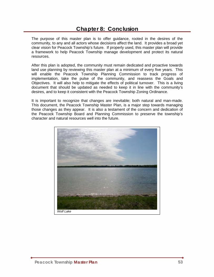
PPeeaaccoocckk TToowwnnsshhiipp MMaasstteerr PPllaann 5533
Chapter 8: Conclusion The purpose of this master plan is to offer guidance, rooted in the desires of the community, to any and all actors whose decisions affect the land. It provides a broad yet clear vision for Peacock Township’s future. If properly used, this master plan will provide a framework to help Peacock Township manage development and protect its natural resources. After this plan is adopted, the community must remain dedicated and proactive towards land use planning by reviewing this master plan at a minimum of every five years. This will enable the Peacock Township Planning Commission to track progress of implementation, take the pulse of the community, and reassess the Goals and Objectives. It will also help to mitigate the effects of political turnover. This is a living document that should be updated as needed to keep it in line with the community’s desires, and to keep it consistent with the Peacock Township Zoning Ordinance. It is important to recognize that changes are inevitable; both natural and man-made. This document, the Peacock Township Master Plan, is a major step towards managing those changes as they appear. It is also a testament of the concern and dedication of the Peacock Township Board and Planning Commission to preserve the township’s character and natural resources well into the future.
Wolf Lake

Appendix a1
Appendix A Public Notices and Approval Process
This section chronicles efforts of Peacock Township to invite the public, neighboring communities, and public utilities to participate in the planning processes for the Peacock Township Master Plan. Also included are meeting minutes and resolutions relevant to the development and adoption of this document. Notice of Intent to Plan – Below is an example of the letter that was mailed to the listed
entities on May 16, 2011.
Lake County Cherry Valley Township
Eden Township Elk Township
Newkirk Township
Sauble Township Sweetwater Township
Webber Township AT&T Communications
Great Lakes Energy

Appendix a2
Public Hearing Notice – Published in the Thursday, May 26, 2011 edition of the Lake
County Star.
Border Review – Below is an example of the letter that was sent on January 20, 2012 to the same entities that were sent a Notice of Intent to Plan.

Appendix a3
Public Review and H earing Notice – Published in the Thursday, March 1, 2012 and Thursday, March 22, 2012 editions of the Lake County Star.
Planning C ommission Approval Minutes – Following the Public Hearing on April 10,
2012, the Planning Commission approved the proposed Peacock Township Master Plan and sent it to the Township Board for approval. No comments were received from the public during either the public hearing, or the preceding public review period.

Appendix a4
Peacock T ownship B oard Approval – The Peacock Township Master Plan was approved, via roll call vote, by the Township Board, on April 25, 2012.

Appendix a5
Resolution of Adoption – The Peacock Township Planning Commission passed a resolution to adopt the proposed Peacock Township Master Plan on July 10, 2012.
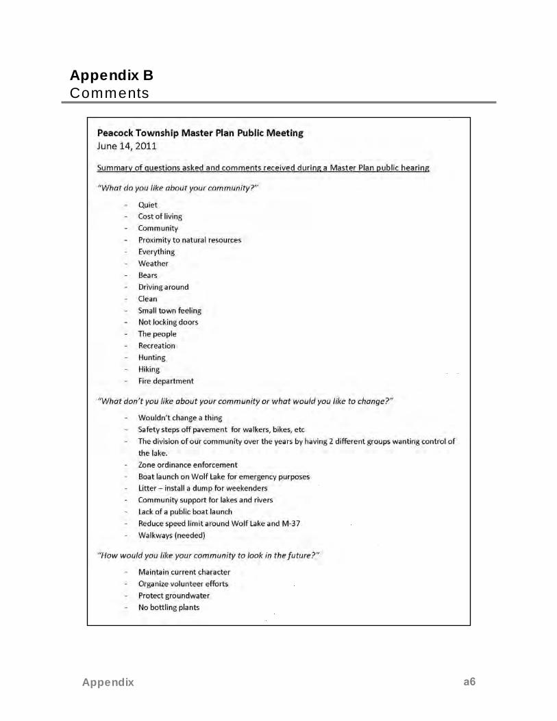
Appendix a6
Appendix B Comments

Appendix a7
Appendix a8
Appendix C Peacock History
This section features photographs and written accounts and reflections from current and former Peacock residents. It is included in this master plan in an effort to preserve the unique history of the area.
A Letter to Marcia by Ruth Stenberg Moore
The Peacock pickle warehouse was on the southwest corner of intersection of 4 Mile Road & Irons Road. They had large vats that the pickles were stored in as the area farmers delivered them. When vats were full, they were shipped on the train to be canned or put in kegs by Squire Dingee Co. (I think in Chicago). There is still salt in the soil. My father-in-law was in charge of it.
The Peacock Livery (with oxen) was in the same block. They also had horses. People from the city would come up on the train. Then they and their luggage would be taken by the livery driver to their cottages on all the area lakes.
There was a siding on northwest corner of 4 Mile & Irons because trains ran east/west and north/south. People still find odds and ends of metal with Geiger counters.
Indian families stayed in box cars, tepees, etc. every summer while they picked wild blueberries and they were shipped in crates to cities. A few Indian families were here when I moved here in 1945.
The first Peacock Postmaster was William Morris. He was appointed in 1923 by the Postmaster General.
In the 1930’s children went to elementary school in Peacock and high school in Luther. In the 40’s it was elementary in Irons and high school in Baldwin. In the 50’s they all went to Baldwin.
The cemetery used to be for colored folks only. Mr. Huckleberry was the first white person buried there. He lived next door to it. Jason Moore made the new gate and cemetery sign, etc. to earn his Eagle Scout medal.
There was a large CCC camp on the east side of M37 near 4 Mile Road in the 30’s (I think). They had a shack for dynamite a short distance behind the present senior center.
There were about 8 colored families in Peacock in the 40’s. Mr. Vincent used to carve wooden bowls and spoons and talk about his days as a slave.
Several of the locals had stills out in the woods and one man still had one in the 50’s.
There was a county garage (it had been sold to owners of a drilling company) on the southeast corner of 4 Mile and Irons. It burned down in about 1972 after an explosion of natural gas. I think the gas wells in this area were drilled in the 60’s, but I don’t know if there’s one still in use or not.
Excuse the scrawl. It’s late and my arthritic fingers ache tonight. If I think of anything else I’ll let you know. My son might know other things. My husband was born in 1920 and raised in Peacock and he discussed its history with our children who were all raised here. The trains still went by our house when the kids were small. My mother would come from Chicago to Peacock to visit and they would stop the train right by our house. Engineers would throw flares off for the kids.
My sister-in-law was the township clerk for many years and sometimes the board members didn’t get paid because of lack of money. I was a trustee for about 30 years. My husband was

Appendix a9
constable and later my son was also. Guess it was a family affair because no one wanted the jobs.
We used to have a quilting bee in the old school house in the 50’s. We gave the quilts to needy people.
My family started the Peacock VFW Post in 1976. Fred and Ruth Smith told us who to contact, etc. Meetings were in the township hall until the post was built on m37.
The grocery store was a few feet east of the Senior Center building. It changed owners several times.
We lived in the school house from 1946 until early 1948. I cooked on a kerosene stove with a portable oven over one burner. We had an upright ice box. We got a gasoline powered washing machine in late 1947. I had a gasoline iron but the noise from it scared me so I did as little ironing as possible. We put a hand pump inside during our stay but it was outside at first. I weighted 100lbs and had to jump up and pull the handle down with all my power to prime the pump.
Myrtle Moore and her mother did laundry for the CCC camp in a house separate from their own. They used a gasoline powered washing machine. They pumped water and heated it in a copper boiler tub on a wood stove. Imagine the heat in summer. Winter was bad when they hung laundry outside to dry. The bell monument in front of the township hall was dedicated to Myrtle Moore for all her years of service to the township.

Appendix a10
Ruth Neilson (Hodgins)
I was born in Peacock in 1925 and left in 1938 so I have a few memories of that area, which used to be called Canfield Corners. My father had a grocery store there. It began as a hotel & livery stable across from the depot and owned by his grandmother who had supplies for the fisherman and took them to fishing camps in the area. My father had the house and store moved so it would be on the main road. He had gas pumps, post office and groceries and ice to sell the “summer” people and locals. He kept a couple cows and sold milk and cream and wonderful ice cream. My mother had Sunday dinners too.
I went to a one-room schoolhouse. There were only 13 pupils when I left after 8th grade. We walked by the Pickle Station on our way. Cows gathered there because of the salt – the pickles were put in large vats until they were picked up by train. Anyway we were always afraid of the cows! There was an old depot where we played and always hoped there were no hobos there. The train stopped to leave mail that was taken to the Post Office which was in our store, but later moved to our house. People came and went – ordered baby chicks which made a lot of noise. There was a little church that the Blacks had built. My Grandfather donated the bell for it. My sister and I would go sometimes – also to the prayer meetings that were held in various homes – the children were expected to recite Bible verses.
The town was made up of white, black, and Indian heritage. The black families were always nice to us.
My father would set our radio on the porch so people could come listen to the Joe Louis fights. I had a carefree childhood in this simple place, but we were all thrilled to move to Gaylord for my freshman year!
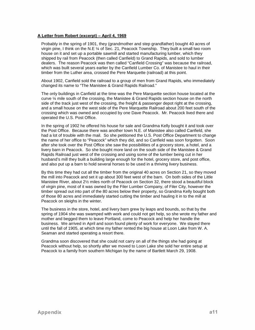
Appendix a11
A Letter from Robert (excerpt) – April 4, 1969
Probably in the spring of 1901, they (grandmother and step grandfather) bought 40 acres of virgin pine, I think on the N.E ¼ of Sec. 21, Peacock Township. They built a small two room house on it and set up a portable sawmill and started manufacturing lumber, which they shipped by rail from Peacock (then called Canfield) to Grand Rapids, and sold to lumber dealers. The reason Peacock was then called “Canfield Crossing” was because the railroad, which was built several years earlier by the Canfield Lumber Co. of Manistee to haul in their timber from the Luther area, crossed the Pere Marquette (railroad) at this point.
About 1902, Canfield sold the railroad to a group of men from Grand Rapids, who immediately changed its name to “The Manistee & Grand Rapids Railroad.”
The only buildings in Canfield at the time was the Pere Marquette section house located at the curve ¼ mile south of the crossing, the Manistee & Grand Rapids section house on the north side of the track just west of the crossing, the freight & passenger depot right at the crossing, and a small house on the west side of the Pere Marquette Railroad about 200 feet south of the crossing which was owned and occupied by one Dave Peacock. Mr. Peacock lived there and operated the U.S. Post Office.
In the spring of 1902 he offered his house for sale and Grandma Kelly bought it and took over the Post Office. Because there was another town N.E. of Manistee also called Canfield, she had a lot of trouble with the mail. So she petitioned the U.S. Post Office Department to change the name of her office to “Peacock” which they did, and so Canfield was soon forgotten. Soon after she took over the Post Office she saw the possibilities of a grocery store, a hotel, and a livery barn in Peacock. So she bought more land on the south side of the Manistee & Grand Rapids Railroad just west of the crossing and using some of the lumber being cut in her husband’s mill they built a building large enough for the hotel, grocery store, and post office, and also put up a barn to hold several horses to be used in a thriving livery business.
By this time they had cut all the timber from the original 40 acres on Section 21, so they moved the mill into Peacock and set it up about 300 feet west of the barn. On both sides of the Little Manistee River, about 2½ miles north of Peacock on Section 32, there stood a beautiful block of virgin pine, most of it was owned by the Filer Lumber Company, of Filer City, however the timber spread out into part of the 80 acres below their property, so Grandma Kelly bought both of those 80 acres and immediately started cutting the timber and hauling it in to the mill at Peacock on sleighs in the winter.
The business in the store, hotel, and livery barn grew by leaps and bounds, so that by the spring of 1904 she was swamped with work and could not get help, so she wrote my father and mother and begged them to leave Portland, come to Peacock and help her handle the business. We arrived in April and soon found plenty of work for everyone. We stayed there until the fall of 1905, at which time my father rented the big house at Loon Lake from W. A. Seaman and started operating a resort there.
Grandma soon discovered that she could not carry on all of the things she had going at Peacock without help, so shortly after we moved to Loon Lake she sold her entire setup at Peacock to a family from southern Michigan by the name of Bartlett March 29, 1908.

Appendix a12
Wolf Lake History
(Al Rockwell was a founding member of the Association)
Al Rockwell was born in Luther in 1924. The first summer he stayed at Wolf Lake was in a tent in 1929.
Al’s father was Delos Rockwell and was born in 1886. The Rockwell home was moved from Luther to the south side of Keystone Park. The long house across from Keystone Park was Grandma Rockwell’s store in the 1920’s.
Originally, there were no bluegills in Wolf Lake. Delos Rockwell was Superintendent with the Conservation District and in the early 30’s brought little bluegills in milk cans and put them in at Keystone Park. The CCC Camp was across from Club 37 and they planted 150 brush piles in Wolf Lake during the 30’s.
One of the early cabins belonged to S.G. Pinyon and was located at the northeast corner of Wolf Lake Drive and East End. The Pinyon family had an orchard in Grand Rapids. They would come up here to hunt after they harvested their fruit. Al as a young man would go hunting with them.
Early residents on the south side of the lake were The Petersens and the Bells. Site of Bouwkamp House (2210) was Katie and Osmond Vincent. She found a huge carp in the lake once.
Buzzo’s cabins were on the west side and were vertical logs. Al helped drive the logs here and Buzzo split and built cabins. He did a lot of work for Wolf Lake.
The railroad ran along the west side of the lake. Wolf Lake Station was a flag stop where the ranch is now. There was a train that left Chicago around 5:00 P.M. and roared through here around midnight. It returned on Sunday. The hotel was abandoned in the 30’s and Al and other kids used to play in it. Later it was converted to a dude ranch.

Appendix a13

Appendix a14
Hotel & Store
Hotel & Store

Appendix a15
Hotel de Gale
Livery

Appendix a16
African-American Church
Native American Family

Appendix a17
Town Hall & School House – Built in 1915

Appendix a18
1929
(Undated)

Appendix a19
Wolf Lake Resort Pamphlet - Page 1

Appendix a20
Wolf Lake Resort Pamphlet - Page 2

Appendix a21
Wolf lake Resort Clubhouse

316 Morris Avenue - Suite 340 - PO Box 387 - Muskegon, MI 49443-0387
Telephone: 231/722-7878 - Fax: 231/722-9362
www.wmsrdc.org - [email protected]