PE 2 CORRECTION - California · 10/06/2013 · CORRECTION 2 This is to correct ... DRN BY: AET SEE...
26
RECORDED AT REQUEST OF Ventura LAFCO #53 NO FEES PER GOVERNMENT Code 27383 WHEN RECORDED MAIL TO Ventura LAFCO L# 1850 lilllililil ilililililt il til I llililil I I I il til 2ø130522-ø00$ I 33-0 I /26 Ventura County Clerk ànd R€corder NARK A. LUNN ost22t2013 03 36.50 pM 719403 $ 00 PE (FOR RECORDER'S USE ONLY) CERTIFICATE OF COMPLETION CERTIFIED MAP AND LEGAL DESCRIPTION LAFCO 10-12 City of Santa Paula Reorganization - East Area 1 CORRECTION 2 This is to correct the maps and legal descriptions (Exhibit A of the Resolution) recorded as part of the original Certificate of Completion, lnstrument Number 20130212-00026869-0 and also recorded as part of lnstrument Number 20130307-00041 1 B7-0 Page 1 CORRECTION 2 -Correcting the Certifìed Map and Legal Description only-(Exhibit A to the resolution of approval referenced in the Certifìcate of Completion and recorded as lnstrument Number 20130307-00041 187 -0 and 201 30212-00026869-0) Page 2-B Certified Map and Legal Description as "Exhib¡t A" to the Resolution titled: "LAFCo 10- 12 RESOLUTION OF THE VENTURA LOCAL AGENCY FORMATION COMMISS/ON MAKING DETERMINÁIIONS AND APPROVING THE CITY OF SANTA PAULA REORGANIZATION - EASI AREA 1 ; ANNEXATION TO THE CITY OF SANTA PAULA AND DETACHMENT FROM THE VENTURA COUNTY FIRE PROTECTION DISTRICT, THE VENTURA COUNTY RESOURCE CONSERVATION D/STR/CT, AND couNTY sERv/cE AREA NO. 32) Page 9-26 CORRECTION - Correcting the Certificate of Completion list of Assessor's Parcel numbers involved in the reorganization only- recorded March 7,2013 as lnstrument Number 20130307-00041 187-0 - (Exhibit A1) Page 12-26 Certificate of Completion originally recorded on February 12,2013 as lnstrument Number 201 30212-0004689-0 (Exhibit A) Pages 2-8 (The Certified Map and Legal Description of this CORRECTION 2 replaces pages 20-26 of this recoded document)
Transcript of PE 2 CORRECTION - California · 10/06/2013 · CORRECTION 2 This is to correct ... DRN BY: AET SEE...

RECORDED AT REQUEST OFVentura LAFCO #53
NO FEES PER GOVERNMENT Code27383
WHEN RECORDED MAIL TOVentura LAFCOL# 1850
lilllililil ilililililt il til I llililil I I I il til
2ø130522-ø00$ I 33-0 I /26Ventura County Clerk ànd R€corderNARK A. LUNNost22t2013 03 36.50 pM
719403 $ 00 PE
(FOR RECORDER'S USE ONLY)
CERTIFICATE OF COMPLETIONCERTIFIED MAP AND LEGAL DESCRIPTION
LAFCO 10-12 City of Santa Paula Reorganization - East Area 1
CORRECTION 2
This is to correct the maps and legal descriptions (Exhibit A of the Resolution) recorded as part of theoriginal Certificate of Completion, lnstrument Number 20130212-00026869-0 and also recorded aspart of lnstrument Number 20130307-00041 1 B7-0
Page 1 CORRECTION 2 -Correcting the Certifìed Map and Legal Description only-(Exhibit A tothe resolution of approval referenced in the Certifìcate of Completion and recorded aslnstrument Number 20130307-00041 187 -0 and 201 30212-00026869-0)
Page 2-B Certified Map and Legal Description as "Exhib¡t A" to the Resolution titled: "LAFCo 10-12 RESOLUTION OF THE VENTURA LOCAL AGENCY FORMATION COMMISS/ONMAKING DETERMINÁIIONS AND APPROVING THE CITY OF SANTA PAULAREORGANIZATION - EASI AREA 1 ; ANNEXATION TO THE CITY OF SANTAPAULA AND DETACHMENT FROM THE VENTURA COUNTY FIRE PROTECTIONDISTRICT, THE VENTURA COUNTY RESOURCE CONSERVATION D/STR/CT, ANDcouNTY sERv/cE AREA NO. 32)
Page 9-26 CORRECTION - Correcting the Certificate of Completion list of Assessor's Parcelnumbers involved in the reorganization only- recorded March 7,2013 as lnstrumentNumber 20130307-00041 187-0 - (Exhibit A1)
Page 12-26 Certificate of Completion originally recorded on February 12,2013 as lnstrumentNumber 201 30212-0004689-0 (Exhibit A)
Pages 2-8 (The Certified Map and Legal Description of this CORRECTION 2 replaces pages 20-26 ofthis recoded document)
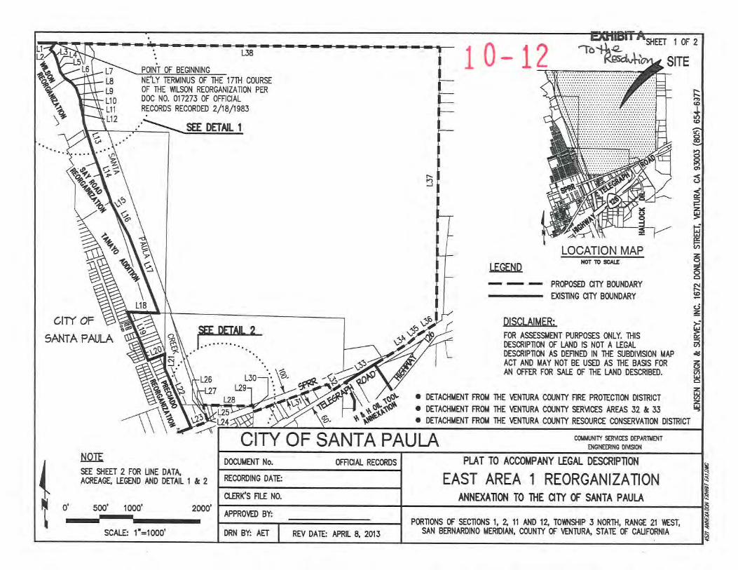
NAT TO ACOOITPAI{Y I.EGAL DESCRIPTIO{
EAST AREA 1 REORGANIZATONNNÐilÏO}I TO THE qTY OF SAllTA PAULA
P0Rror{s 0F sEcrot{s 1, z 11 AND 1¿ T0m6Hp 5 NoRÌH, RNGE 21 IESI,SAN ffTNARDII{O }¡ERIDIAI{, COTJNTY tr VE{ruRÀ STAIE OF CruFffi{IAREV D rÊ APRL 6, 2013
CITY OF SANTA PAULA CilH,lNTY SAUCES OEPTRilÛÎÐtot{EERt¡c onígct{
OFRqAL RECORDSDOûJI|ENT No.
RECORDING DA'IÊ
ctER('s RtI N0.
APPRO\trD BY:
DRN BY: AET
SEE DETÄL 2
.l
L2E
õ¡J
r\3
L3E
L7NE'LY IERMINUS OF THE 17I}I COTJRST
OF'IHE TTII.SON REORGANIZATON PER
Doc N0. 017273 0F oFRC|ALRECoRDS RECoRDED 2/18/1s83
L8
L9
Lr0LtlL12
7
118
10- 12'fò 1ç2
SITE
LOCATION MAP
I.TGEND þf IO æ^II
- - - PRoPoSÐ OTY BCIJNDARY
-
EXSnNG 0W BoUNDARY
DISCN.AIMER:
FOR ASESSIIÐ{T PURPOSES OT{LY. THISDESCRIPTSI OF I.AND 15 NOT A IEGALDESCRPNOil AS Í)ERNED IN IHE SJBDIVSOI{ IIAPACT ND UAY NOT BE USÐ AS THE BASS FOR
AI{ ffFER FOR SATT tr THE LAT{O D€SCftBÐ.
\\
. DETAfiIENT FROT THE Vtr{TURA COI,,NTY RRE PROIECTOTI US:IRICT
O DETAO{}¡Ð{T FROIT THE !É{TURA COUNTY S$N,ICES AREAS 52 & 33. DEÍACIITIÐ{T FROI¡ lHE IE{IURA COUNTY RESOT.IRCE CONSERVATIOI{ DISIRICT
NOTE
SEE SHTTT 2 FOR UNE DATÀACREAGE I..EGÐ{D ND DETÀL'I & 2
0' 5(x)' looo' z(x)o'
-SCAte 1'=1@0'
SAI.TTA PA'I.A
CITI OF

The Ventura County Surveyor's ofüce of the Publlc Wo¡ks Agencyæñlfres fhis map and legal desaiption to be.deñnile and ceda¡n.
4zâ-Ceftified by:tuDa]rl: I t+ 2ô t4

PLAT TO ACCOITPAÌ{Y I.EGAL DESCRIPÏIOI{
EAST AREA 1 REORGANIZATONAI{NÐONON TO 'IHE OTY OF SAT{TA PAUI.A
PoRÎO{S 0F SICToNS 1, Z 11 AND 1¿ ToTûtSHtp 3 NoRIH, R^I{GE 21 hEST,SA¡I BERNARDINO MRIDIAN, COI'NW OF VÛruRA, STA'ÍE OF CruFOff}¡IAREV DATE APRIL E 2OI5
CITY OF SANTA PAULA cflnilï s8l,tcEs oemmtt$GltmfiG mlsl(r{
OFROAL RECORDSDOCLIIÐ{T No
RECOrcNG DAIÉ
ct-ERt('s F[.I N0.
APPROVED BY:
DRN BY: AET
2ff 2
UNE DATAUNE BEARING DISTANCE
4TBEA6n.+t0
-tð1I I-DISTANCE
116.96'
69.34'1æ.n'100.13'
100.28'
104.99'123.E1'
106.98'
200.00'
101.83'
10201'124.4ti545.32'
657.32''r206'
575.00'r15200'460.00'763.47'
BEARING
N69!0'00'Es00'40'00'trs25r1'42'EN6935',l7'EN22'38'00'llN702E 47'VfN2020 59'Vf
N1223'23'W
s8856'23'EN6935't7'Es005J'5ftTN69T5'17'Es3138'{t'EN5724 54'EN572{54'EN4853'00'EN572{54'EN00r7'19'w
ITEST
255.05'
188.02'980.00'
268.82'
29.34'J.17'
n.4E'ß3.n'686.24'
60.41'
107.34
1179.27'
11J.J0'10n.57'258.62'
202.24'
306.67'39Tr.5{fiT|.57'
UNE ACRES, MORE OR lfss
TTGEND
SPRR SOUTHEM{ PAORC RAII'ROAI)
L1
L2
LJ
L4
L5
L6
L7
L8
L9
110
111
112
113
114
115
116
117
118
L't9
s3429'17'rIs49T9'29'Es24T2'03'E$7f5,+ô'Esl626'17'Es3827'51'Es5651'01ts,+1T1'37'E
s20'4J'1J'Es095/29'Es092{s4,Es08r7'0J'ES18',+3'47'E
s21r7'21'ts5453'50'lTs29!5'01'Es2225'21'ENE933'55'tV
s24!0'00'E
olct+lfl@
ä(J
a0a1L22L23a1a5126
L27
t28u9130
131
132
133
131
135
136
L37
138aac¡(\I
Idz,
€6ø,Bza-ry
?q,q
ú7a-.
t--138 --+POINT OF BTGINNING
DETAIL 1
NOT TO SCAI.E
128
?
DETAIL 2NOT TO SCAI.T
or.)J
DISCI-{IMER:
FoR ASS€SSilÐ{T PURPoS€S or{LY. rHrSDESCRIPTü.I OF LAIID IS NOT A I..EGAL
OæCroPTO¡ AS DMNÐ N THE SUBDIVSON TIAPACT ND MAY NOT BE USED AS THE EASS FOR
A¡I OFFER FOR SAII OF lHE I.AI.¡D D€SCftBÐ.
O DETAO.IIIE}IT FROT THE IE{TURA COI'NTY RRE PROTECTOT{ USTRCT
O DEÍACTII¡SIT FROI 'IHE !Ð{'IURA COTJNTY SERVICES ARE¡S 32 E J3O DETACHilTilT FROI¡ THE !6ITURA Clt'lNTY RESOURCE COI{SERVAION DISTHCT
z
1g
The Ventun County Swwfis offiæ oî the Pubfrc Wo*s Agencyæñlñesthß map md legal desuíplbln to be &ñnlte and æñain.
Cedifadby: árr"Date: l/t+lzltz
l'"t

t 0- L2CITY OF SANTA PAULA REORGANIZATION
EAST AREA I EGilBtTAANNEXATIoN To THE CITY oF SANTA PAULA AND DETACHMENT FROM +-" -4+.
THE vENTURA couNTy RESouRCE coNSERVATIoN DISTRICT AND f csetu+-t'd)\
DETACHMENT FROM THE VENTURA COUNTY FIR.E PROTECTION DISTRICTAND DETACHMENT FROM COUNTY SERVICE AREAS 32 AND 33
Those portions of Sections 1,2, ll and 12, Township 3 North, Range 2l West, San BernardinoMeridian, in the County of Ventura, State of California, as shown on the Official Plat of saidland, described as follows:
Beginning at the northeast corner of Parcel 3 as shown on the Parcel Map filed in the Offrce ofthe County Recorder of said County of Ventura, in Book 37, Pages 2L-23, inclusive, of ParcelMaps, said corner also being the northeasterly terminus of the lTth course of the WilsonReorganization, Annexation to the City of Santa Paula and Detachment from the Venfura CountyResource Conservation District and Detachment from the Ventura County Fire ProtectionDistrict, as described and shown in the Certificate of Completion recorded February 18, 1983, inthe Offrce of said County Recorder, in Document No. 017273 of Official Records; thence, alongthe boundary of said Parcel Map by the following14 courses, and along the existing boundary ofsaid City of Santa Paula by the following 22 courses:
I't South 34"29'17" West, 116.96 feet; thence,
2"d South 49"39'29" East, 69.34 feet; thence,
3rd South 24"32'03" East, l00.22feet;thence,
4th South 17"05'46" East, 100.13 feet;thence,
5th South 16"26'17" East, 100.28 feet; thence,
6th South 38"27'51" East, 104.99 feet; thence,
7'h South 56o51'01" East, 123.81 feet;thence,
8th South 41"31'37" East, 106.98 feet; thence,
9th South 20"43'13" East, 200.00 feet; thence,
lOth South 09"57'29" East, 101.83 feet; thence,
I lth South 09"24'54" East, 102.01 feet; thence,
l2th South 08o17'03" East,124.45 feet; thence,
l3th South 18"43'47" East, 545.3 2 feet;thence,
4521 Ex A Annexation.docPage I of 3

l4th
l5,h
l6th
l7'h
l gth
lgth
zoth
2l't
22"d South 25"11'42" East, 980.00 feet to the north line of the Southern Pacific Railroad Rightof Way, 100.00 feet wide; thence leaving said City of Santa Paula boundary and alongsaid north line of railroad,
23'd North 69"35'17" East, 268.82 feet to the most easterly corner of the deed to VenturaCounty Flood Control District recorded August 2,1973 in Book 4148, at Page 292 ofOfficial Records of said county; thence along the boundary of said deed by the following2 courses:
24th North 22"38'00" West, 29.34 feet; thence,
25th North 70"28'47" West, 3.17 feetto the easterly line of the deed to Ventura CountyFlood Control District recorded September 10, 1999 in Document No. 99-174284 ofOfficial Records of said county; thence along said easterly line,
26th North 20"20'59" West, 77.48 feet to the easterly line of the deed to County ofVentura recorded December I 8, 1928 in Book 236, at Page 3 I 7 of Official Recordsof said county; thence along last said easterly line,
27th North 72"23'23" West, L43.77 feet to the north line of Lot 2 of said Section I I as
shown on the Record of Survey Map filed in the Offrce of said County Recorder, inBook 15, Page 5 I of Records of Survey; thence, along said north line of Lot 2,
28th South 88o56'23" East, 686.24 feet to said north line of the Southem Pacific RailroadRight of Way, 100.00 feet wide; thence along said north line of railroad,
zgth Norlh 69o35'17" East, 60.41 feet to the northerly prolongation of the east line ofFerris Gardens as shown on the Record of Survey map filed in the Office of saidCounty Recorder, in Book 4, at Page 37 of Records of Survey; thence along saidprolongation,
South 2lol7'21" East, 657.32 feet; thence,
South 54o53'50" West, 12.06 feet; thence,
South 29o05'01" East, 575 feet, more or less; thence,
South 22"25'21" East, I 152 feet, more or less; thence,
North 89o33'55u West, 460 feet, more or less; thence,
South 24o00'00' Bast,763.47 feet; thence,
North 69o00'00" East, 255.05 feet; thence,
South 00o40'00" West, 188.02 feet; thence,
\I
4521 Ex A Annexation.docPage 2 of 3

10- L230th South 00o53'52u West, 107.34 feet to the south line of said Southern Pacific Railroad
Right of Way, 100.00 feet wide; thence along said south line,
3l't North 69o35'l7u East, I 179.27 feet to the most westerly corner of Parcel I as
described in the deed recorded November 24,1998, in Document No. 98-205985 ofOfficial Records of said county; thence along the southwest line of said Parcel I ,
32nd South 31o38'43' East, I13.30 feet to the north line of Telegraph Road, 60.00 feetwide as described in the deed to Ventura County recorded May 3, l9l6 in Book 150,at Page l2l of Deeds of said county; thence along said north line,
33'd North 57"24'54" East, 1077.57 feet to said north line of said Southern PacificRailroad Right of Way, 100.00 feet wide, at251.50 feet the southwesterly terminusof the 9th course of the H & H Oil Tool Annexation to the City of Santa Paula as
described and shown in the Certificate of Completion recorded October 27,1978 inBook 5246, at Page ó31 of Official Records of said county, at 750.00 feet thenortheasterly terminus of said 9th course of the H & H Oil Tool Annexation; thencecontinuing along said north line of Telegraph Road (State Highway 126) by thefollowing 3 courses:
34th North 57o24'54" East, 258.62 feetto the westerly corner of the deed to the State ofCalifornia recorded September 21, 1953 in Book 1157, at Page 570 of OfficialRecords of said county; thence along the northerly line of the last said deed by thefollowing 2 courses,
35th North 48o53'00" East,202.24 feet; thence,
36th North 57o24'54u East, 306.67 feetto the east line of the SW l/4 of the SW l/4 ofsaid Section 1; thence along said east line to and along the east line of the NW 1/4 ofthe SW l/4 of said Section I to and along the east line of the SW l/4 of the NW l/4of said Section l,
37th North 00o I 7' 19" West, 3977 .54 feet to the northeast corner of said SW I /4 of theNW 1/4 of Section 1; thence along the north line of said SV/ l/4 of the NW l/4 ofSection l, to and along the north line of the SE l/4 of the NE l/4 of said Section 2,to and along the north line of the SW l/4 of the NE 1/4 of said Section 2, to andalong the north line of the SE l/4 of the NW l/4 of said Section 2, to and along thenorth line of the SW 1/4 of the NW l/4 of said Section 2,
38th West, 5677.57 feet to the Point of Beginning.
Contains: 540.41acres, more or less.
For assessment purposes only. This description of land is not a legal description as definedin the Subdivision Map Act and may not be used as the basis for an offer for sale of the landdescribed.
The Venlura County Surveyor's office of the Public Works Agencyce¡'tifìes thisCerlified by:
to be definite and
4521 Ex A Annexation.docPage 3 of 3

CORRECTION
LAFCO 10-12CERTIFICATE OF COMPLETION
of Santa Paula anization - East Area 1
E'GIIBITAlRECORDED AT REQUEST OF
Ventura LAFCO #53
NO FEES PER GOVERNMENT CODE 27383
WHEN RECORDED MAIL TOVentura LAFCO
L# I 850
Page 1
Page 2Page 3Page 4- 18
mll il illll ltillillilllill lil l[
2ot¡o¡ol-ooo4l18?-o 1/18Ventuta Ccrurrty Clerk encl RecorderMARK Ê LUNI{
o3/o7,2013 09 01 .12 All
696013 $ 00 cE
(FOR RECORDER'S USE ONLY)
This is to correct the Certificate of Completion recorded as lnstrument No. 20130212-00026869-0recorded on February 12,2013.
The Certificate of Completion recorded February 12,2013 contains only a partial list of APN numbersinvolved in the reorganization "LAFCo 10-1 2 City of Santa Paula Reorganization - East Area 1". Thecomplete list of APN numbers involved in this reorganization is labeled "Attachment "1" to thecorrected Certificate of Completion dated March 6,2013 and is part of this correction.
CORRECTIONCertificate of Completion (Correction) dated March 6, 2013Attachment 1 - A complete list of APN numbers involved in this reorganizationCertificate of Completion dated February 12,2013, recorded February 12,2013 aslnstrument Number 20130212-0004689-0 --fxr\trir t ì

No Fees per Covernment Code 27383
RECORDING REQUESTED BY:
Ventura Local Agency Formation CommissionUIIIEN RECORDED MAII TO:
Ventura LAFCo
t# 1850
VeruruRRLocnl Acerucv Fonveroru Coun¡rssroN
800 South Victoria Ave.Ventura CA 93009-'1850
CORRECTION
CERTIFICATE OF COMPLETION
Pursuant to Government Code Section 57200, this Certificate is issued by the Executive Officer of theVentura Local Agency Formation Commission, Ventura County, California.
1. The short-term designation, as determined by LAFCo, is:
LAFCo 10-12 City of Santa Paula Reorganization - East Area 1
The name of each district or city involved in this reorganization and the kind or type of change oforganization ordered for each city or district is as follows:
City of Santa Paula - AnnexationVentura County Fire Protection District - DetachmentVentura County Resource Conservation District - DetachmentVentura County Service Area No. 32 - Detachment
The city and districts listed above are located within the following county: Ventura
APN Numbers: SEE ATTACHMENT 1
The Local Agency Formation Commission's resolution of approval, LAFCo 10-12, which wasadopted on March 16, 2011 is made a part of this certificate by reference and sets forth thedescription of the boundaries of the proposal and any terms and conditions that apply.
6. The territory is uninhabited
I hereby certify that the resolution cited above includes any terms and conditions, and the map and legaldescription. I declare under penalty of perjury that the foregoing is true and correct.
Ki ch,
2
3
4
5
Dated 5 t3Ventura LAFCo
tive Officer
LAFGo 10-12 City of Santa Paula Reorganization - East Area 1
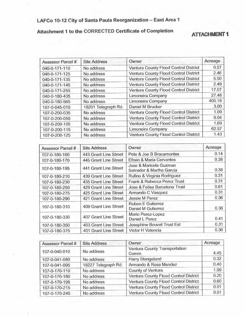
Attachment 1 to the GORRECTED Certificate of GompletionATTACHMENT I
AcreageOwnerSite AddressAssessor Parcel #0.57Ventura County Flood Control DistrictNo address040-0-1 71-1102.46Ventura County Flood Control DistrictNo address040-0-1 71-1255,50Ventura County Flood Control DistrictNo address040-0-1 71-1352.49Ventura County Flood Control DistrictNo addresso40-o-171-145
17.07Ventura County Flood Control DistrictNo address040-0-171-25527.48Limoneira Company040-0-180-435 No address
405.18Limoneira CompanyNo address040-0-1 80-5653.00Daniel M Brucker1 07-0-045-01 5 lS2Ol Telegraph Rd1.09Ventura County Flood Control DistrictNo address107-0-200-0356.04Ventura County Flood Control DistrictNo address107-0-200-0551,69Ventura County Flood Control DistrictNo address1 07-0-200-1 05
62.57Limoneira CompanyNo address1 07-0-200-1 1 51.43Ventura County Flood Control DistrictNo address107-0-200-125
AcreageOwnerSite AddressAssessor Parcel #0.'t4Pete&JoeBBracamontes443 Grant Line Street107-0-180-1600.38Efrain & Maria Cervantes445 Grant Line Street1 07-0-1 B0-1 70
0.38Jose & Maricela GuzmanSalvador & Martha Garcia441Grant Line Street1 07-0-1 80-1 95
0.31Rufino & Virginia Rodriguez107-0-180-210 439 Grant Line Street0.31Frank & Rebecca Perez Trust435 Grant Line Street107-0-180-2300.61429 Grant Line Street Jose & Felisa Barcelona Trust107-0-180-2500.31Armando C Vasquez425 Granl Line Street107-0-180-2750.36Jessie M Perez421 Grant Line Street1 07-0-1 80-290
0.36Ruben E GutierrezDaniel M Gutierrez1 07-0-1 B0-31 0 409 Grant Line Street
0.41Mario Perez-LopezDaniel L Perez407 Grant Line Street107-0-180-330
0.31403 Grant Line Street Josephine Bouvet Trust Est1 07-0-1 80-3500.36Victor H Valencia401 Grant Line Street1 07-0-1 80-375
AcreageOwnerSite AddressAssessor Parcel #
4.45Ventura Co unty TransportationComm.No address107-0-040-010
0.32Harry StangelandNo address1 07-0-041-0800.40Armando & Rosa Mendez107-0-041-095 18227 Telegraph Rd1,09County of VenturaNo address1 07-0-1 70-1 1 00.20Ventura County Flood Control DistrictNo address1 07-0-1 70-1 B00.60No address Ventura County Flood Control District1 07-0-1 70-1 950.01Ventura County Flood Control DistrictNo address107-0-170-2150.01Ventura County Flood Control DistrictNo address107-0-170-245

EXÈrcrl fi'No Fees per Government Code 27383
RECORDING REQUESTED BY:Ventura Local Agency Formation CommissionWUEN RECORIIEII MAIL TO:
Ventura LIFCot# 1850
VeNrunRLocnu Acerucv FoRn¡nroN CoMMrssro
800 South Victoria Ave.Ventura CA 93009-1850
CERTIFICATE OF COMPLETIONDA 3 -7-
Pursuant to Govemment Code Section 57200, this Certificate is issued by the Executive Officer of theVentura Local Agency Formation Commission, Ventura County, California.
The short-term designation, as determined by LAFCo, is:
LAFCo 10-12 City of Santa Paula Reorganization - East Area I
The name of eactr district or city involved in this reorganization and the kind or type of change oforganization ordered for each city or district is as follows:
City of Santa Paula - AnnexationVentura County Fire Protection District - DetiachmentVentura County Resource Conservation District - DetachmentVentura County Service Area No. 32 - Detachment
The city and districts listed above are located within the following county: Ventura
APN Numbers: 040-0-1 7 1 -1 1O: 040-0-1 7 1 -125: 040-0- 1 7 1 - 1 35; 040-0- 1 7 1 -1 45,,
040-0-1 7 1-255; 040-0-1 80-435; 040-0-1 80-565; 1 07-0-045-01 5;
1 07-0-200-035; 1 07-0-200-055; 1 07-0-200-1 05; 1 07-0-200-1 1 5;
107-0-200-125
The Local Agency Formation Commission's resolution of approval, LAFCo 10-12, which wasadopted on March 16, 2011 is made a part of this certificate by reference and sets forth thedescription of the boundaries of the proposal and any terms and conditions that apply
6. The territory is uninhabited
I hereby certify that the resolution cited above includes any terms and conditions, and the map and legaldescription. I declare under penalty of perjury that the foregoing is true and correct.
(_
K , Executive Officer
1302
ilill|iltililil1ll
2-00026869-0 l/15Venturå Countv Clerk and RecortlerI,IARK A LU¡¡N
o2t t2t20t3 02 56 23 Prl689200 ¡ 00 Pa
I HEREBY CERTIFY THAT THISANNE)GD INSTRUMENT IS A
¡ TRUE AND CORRECTCOPY oFTHE DOCUIIENT ON FILE IN THE
1
2
4.
3.
5
Dated: ? t2
Ventura LAFCo

LAFCO 10-12
RESOLUTION OF THE VENTURA LOCAL AGENCYFORTIATION COMMISSION MAKING DETERMINATIONSAND APPROVING THE CITY OF SANTA PAULAREORGANIZATION - EAST AREA 1; ANNEXATION TOTHE CITY OF SANTA PAULA AND DETACHMENT FROMTHE VENTURA COUNTY FIRE PROTECTION DISTRICT,THE VENTURA COUNTY RESOURCE CONSERVATIONDISTRICT, ANO COUNTY SERVICE AREA NO. 32
WHEREAS, the above-referenced proposal has been filed with the Executive
Officer of the Ventura Local Agency Formation Commission (LAFCo or Commission)
pursuant to the Cortese-Knox-Hertzberg Local Government Reorganization Act of 2000
(Section 56000 et seq. of the Califomia Govemment Code); and
WHEREAS, at the times and in the manner required by law, the Executive Otficer
gave notice of the hearing as required by law; and
WHEREAS, the proposal was duly considered on March 16, 201 1 and
WHEREAS, the Commission heard, discussed and considered all oral and
written testimony for and against the proposal including, but not limited to, the LAFCo
Staff Reports and recommendation, the environmental document, sphere of influence
and applicable local plans and policies; and
WHEREAS, not all landowners within the affecled tenitory have consented to the
proposal; and
WHEREAS, the affected territory has more than twelve registered voters and is
considered inhabited: and
WHEREAS, information satisfactory to the Commission has been presented that
no subject or affected agencies have submitted written opposition to the proposal: and
WHEREAS. the Commission fìnds the proposal to be in the best interest of the
landowners and present and future inhabitants within the City of Santa Paula (City) and
within the affected territory, and the organization of local governmental agencies within
Ventura County:
WHEREAS, the Commission certifies that it has reviewed and considered the
Final Environmental lmpact Report (FEIR) prepared by the lead agency; and

WHEREAS, the Commission has found that the FEIR discloses impacts that are
not signilîcant or are mitigated to a level of insignificance; and
WHEREAS. the Commission has found that there remains significant and
unavoidable impac{s that cannot be mitigated to a level of insignificance and that theseimpact findings be made, in accordance with Section 15093 of the CEQA Guidelines;
WHEREAS, the Commission makes a statement of oveniding considerations lhat
based on zubstantial evidence in the record the benefits of the project outweigh the
unavoidable adverse envi ronmental effects:
NOW, THEREFORE, BE lT RESOLVED, DETERMINED AND ORDERED by the
Ventura Local Agency Formation Commission as follows:
(1) The LAFCo Staff Report dated January 19, 2011 and the LAFCo
Supplemental Staff Report dated March 16, 2011 and recommendations in
the latter for approval of the proposal, except as modified herein, are
adopted.
(2) The reorganization is hereby approved, and the boundaries are
established as generally set forth in the attached Exhibit A.
(3) The boundaries of the proposal are found to be definite and certain as
approved.
(4) The subjecl proposal is assigned the following distinctive short form
designation: LAFCO 10-12 CITY OF SANTA PAULA
REORGANIZATION - EAST AREA 1.
(5) The Commission has reviewed and considered the information contained
in the FEIR for the East Area 1 Specific Plan prepared for the City as lead
agency as well as all comments received and determines that there are
not any feasible mitigation measures or feasible alternatives, within the
power and authority of LAFCo, which vtould substantially lessen or aroid
any significant effect on the environment [CEQA Guidelines S15096(g)].
LAFCO 10-12 City of Santa Paula Reorganization - East Area 1
Resolution of ApprovalMarch 16, 2011Page 2 oÍ 7

(6) The commission hereby adopts the lead agency's Findings, Mitigation
Measures and Mitigation fi¡lonitoring and Reporting Program (Attachmenl
28 to the January 19 staff report).
(7) The Commission directs staff to file a Notice of Determination in the same
manner as a lead agency under CEQA Guidelines 515094 and $15096(i).(8) The Commission determines that the project is in compliance with
Govemment Code S 56741 as the territory to be annexed is located within
one county and is contiguous with the boundaries of the City.
(9) The Commission waives the restrictions of Govemment Code Section
56744 prohibiting the creation of unincorporated islands based on the
finding that the area to be enclosed by the annexation (referred to in the
staff report as the East Area 2 island) is so located that it cannot be
reasonably annexed to another city or incorporated as a new city and that
the application of the restrictions vrould be detrimental to the orderly
development of the Santa Paula community in that, until the fiscal and
other benefits of the development of East Area 1 are triggered by approval
of annexation, the City vrlould lack financial and other resources to
adequately serve and improve the East Area 2 island; that additional time
is necessary Íor the City to consider and approve a land use plan for the
East Area 2 island, wtrich the City ultimately intends to function as a
gateway to the City; and that, to the extent the creation of the East Area 2
island othenryise vtould be detrimental to orderly development, such
detriment is offset by the condition offered by the City, and incorporated
below, requiring the City to file an application to annex the East Area 2
island before recordation of the East Area 1 reorganization.
(10) The Commission waives Ventura LAFCo Commissioner's Handbook
Section 3.3.2.2(al, (b) and (c) based on the finding set forth in the
preceding section of this resolution.
(11) The Commission waives Ventura LAFCo Commissioner's Handbook
Section 3.3.5.1(b) based on the finding that annexing smaller portions of
LAFCO 10-12 City of Santa Paula Reorganization - East Area 1
Resolution of ApprovalMarch 16,2011
Page 3 ol 7

the tenitory for the purpose of accommodating a maximum development
timeframe of 5 years would result in illogical boundaries and vrrould not
promote orderly growth and development.
(12) The affected territory is inhabited as defined by Government Code
s56046.
(13) Pursuant to Govemment Code Section 56663(d), written notice of the
Commission proceedings has been provided to all registered voters and
landowners wilhin the affected tenitory and no written opposition to the
waiver of protest proceedings has been received from the affected agency
that will gain tenitory as a result of the proposal or from registered voters
or landowners within the affecied tenitory. The Commission hereby
waives protest proceedings entirely.
(14) The affected territory shall be liable for all taxes, charges, fees or
assessments that are levied on similar properties within the City.
(15) Prior to recordation of the reorganization, the Clty of Santa Paula and
developer shall execute an Operating Memorandum amending the
Development Agreement between them to provlde that the public
safety faclllty shall be compteted prior to occupancy of the 250rh
resldential unit.
(16) Prior to recordation of the reorganizatlon, the Clty and developer
shall execute an Operatlng Memorandum amendlng the Development
Agreement between them to lnclude the following language or
language that ls substantially consistent: To ensure that the City's
wastewater infrastructurc sufficiently meets the needs of the
community, the parties agroe to share in the costs of rehabilitating
the Harvard Boulevard wastewater collection system. Costs will be
paid from, wlthout limltation, the City's 2010 Bond lssuance;
wastewater lmpact fees lncludlng the t1,234,819 identified in Section
LAFCO 10-12 City of Santa Paula Reorganization - East Area 1
Resolution of ApprovalMarch 16, 2011Page 4oÍ7
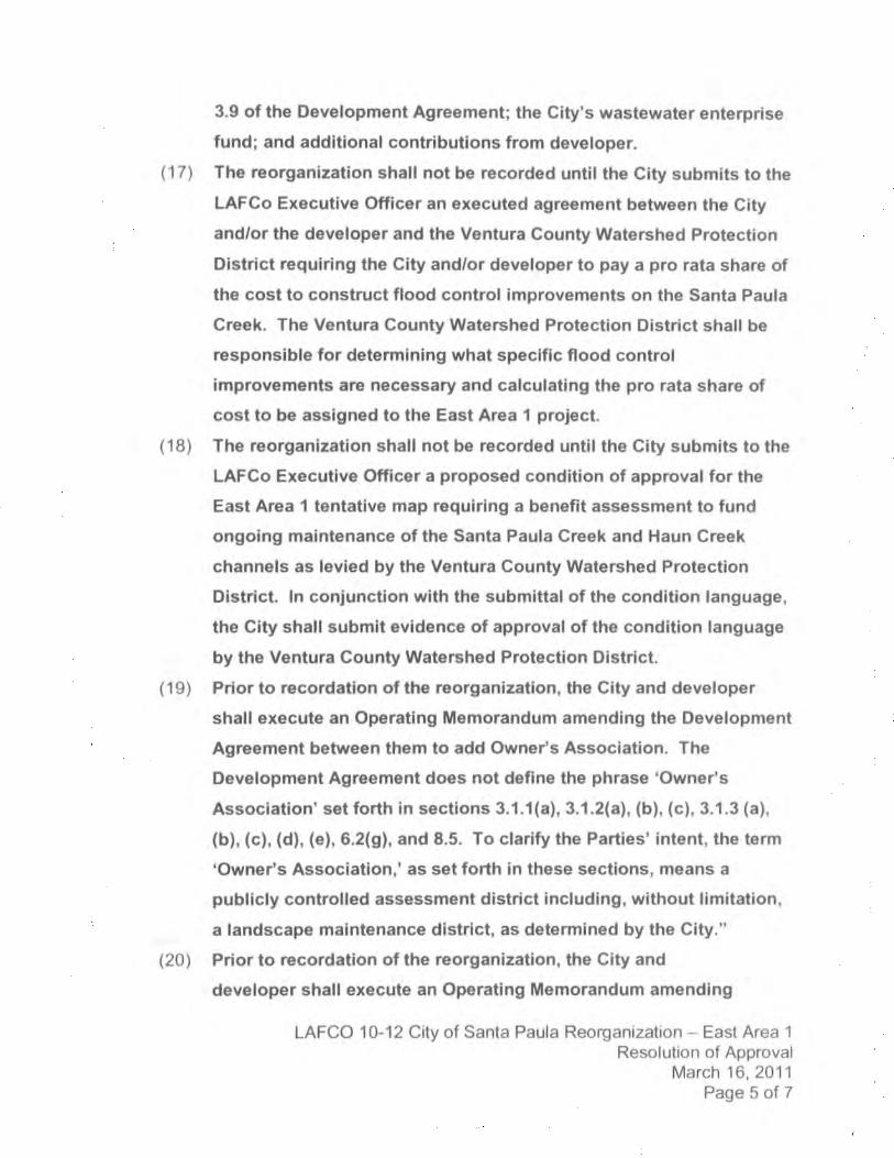
(17l.
(18)
(1e)
(20)
3.9 of the Development Agreement; the city's wastewater enterprise
fund; and addltional contributions from developer.
The reorganization shall not be recorded until the City submits to the
LAFCo Executive Officer an executed agreement between the City
and/or the developer and the Ventura County Watershed Protection
District requiring the CiÇ and/or developer to pay a pro rata share of
the cost to construct flood control improvements on the Santa Paula
Creek. The Ventura Gounty Watershed Protection District shall be
responsible for determining what speclflc flood control
improvements are necessary and calculating the pro rata share of
cost to be assigned to the East Area I profect.
The reorganization shall not be recorded until the City submits to the
LAFCo Executlve Officer a proposed condition of approval for the
East Area 1 tentative map requiring a benefit assessment to fund
ongoing maintenance of the Santa Paula Creek and Haun Creek
channels as levled by the Ventura County Watershed Protection
District. ln conjunction with the submittal of the condltion language,
the Gity shall submit evidence of approval of the condition language
by the Ventura County Watershed Protection District.
Prior to recordation of the reorganization, the Clty and developer
shall execute an Operating Memorandum amending the Development
Agreement between them to add Owner's Association. The
Development Agreement does not deflne the phrase 'Owner's
Association' set forth in sections 3.1.1(a), 3.1.2(a), (b), (c), 3.1.3 (a),
(b), (c), (d), (e), 6.2(g), and 8.5. To clarify the Parties' intent, the term
'Owne/s Association,' as set forth in these sections, means a
publicly controlled assessment district includlng, without limitation,
a landscape maintenance dlstrict, as determined by the City."
Prior to recordation of the reorganization, the City and
developer shall execute an Operating Memorandum amending
LAFCO 10-12 City of Santa Paula Reorganization - East Area 1
Resolution of ApprovalMarch 16, 2011
Page 5 oÍ 7

the Development Agreement between them to include: ,,Fiscal
lmpact Deposit. The Fiscal lmpact Deposit set forth in section
8.8 of the Development Agreement must be replenished by
developer each time there is a transfer of any funds to the
City's General Fund to maintain a $2,000,000 balance until such
time as the Development Agreement terminates or for twenty-
five (25) years, whichever is sooner."
(211 Prior to recordation of the reorganization, the Gity and developer
shall execute an Operating Memorandum amendlng the Development
Agreement between them to provlde that the Santa Paula Street
Brldge shall be constructed prior to occupancy of the 251"1
residential unit. Prior to the occupancy of the lrr structure built inEast Area I (residentlal or commercial/ industrial), access to the
prolect site shall be avallable from Hallock Drlve (maln access) and
at least one other at grade emorgoncy acoess point.
(221 Prlor to recordation of the reorganization, the City shall file an
appllcation to annex the entirety of the East Area 2 island.
(23) Thls reorganlzation shall not be recorded until all LAFCo fees have
been paid and until fees necessary for filing with the State Board of
Equalization have been submltted to the LAFCo Executive Officer.
(24) This annexatlon shall not be recorded untll a map and legal
description consistent with thls approval and euitable for filing with
the State Board of Equallzatlon have been submltted to the LAFCo
Executive Officer.
LAFCO 10-12 City of Santa Paula Reorganization - East Area 1
Resolution of ApprovalMarch 16, 2011Page 6 of 7
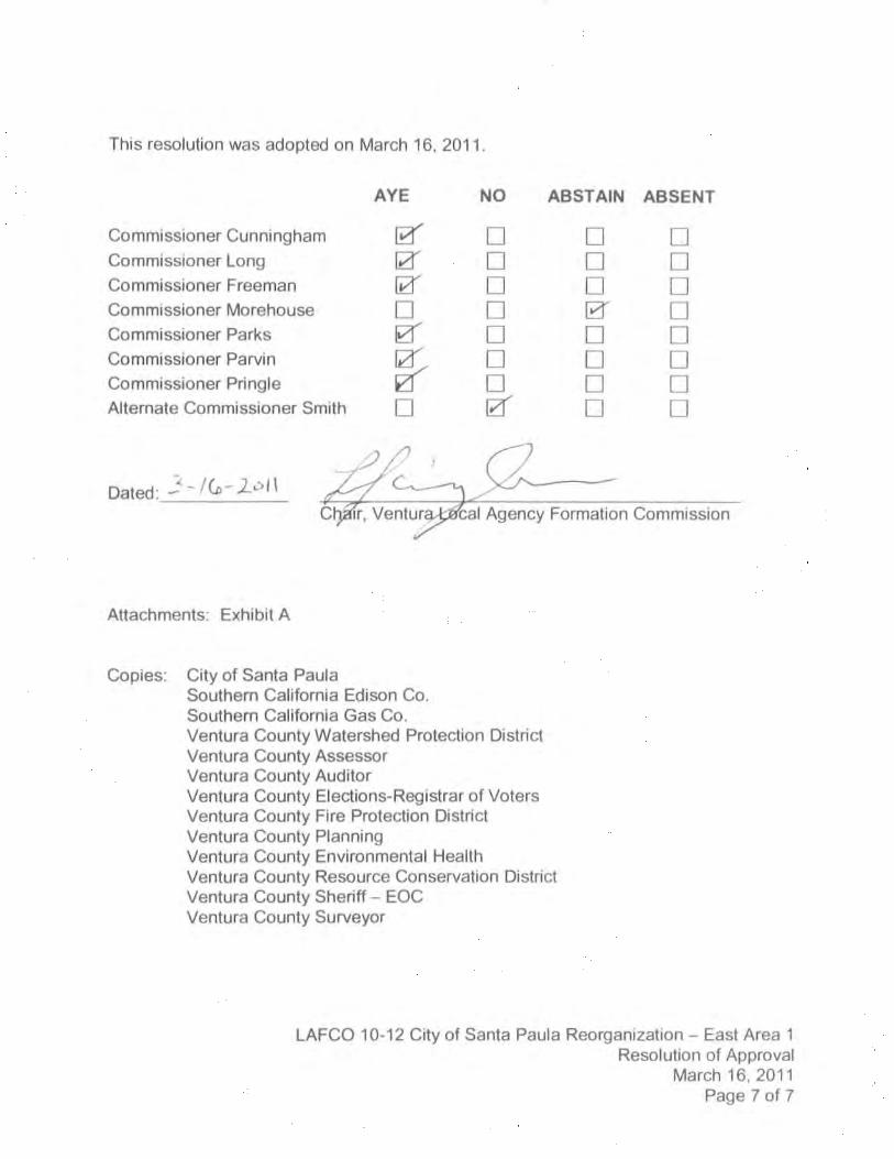
This resolution was adopted on March 16, 2011
Commissioner Cunningham
Commissioner LongCommissioner Freeman
Commissioner Morehouse
Commissioner Parks
Commissioner ParvinCommissioner Pringle
Altemate Commissioner Smith
Dated: -'- l(o-loll
Attachments: Exhibit A
City of Santa PaulaSouthem Califomia Edison Co.Southem Califomla Gas Co.Ventura County Watershed Protec{ion DistrictVentura County AssessorVentura County AuditorVentura County Elections-Registrar of VotersVentura County Fire Proteclion DistriciVentura County PlanningVentura County Environmental HealthVentura County Resource Conservation DistrictVentura County Sheriff - EOCVentura County Surveyor
AYE NO ABSTAIN ABSENT
r, Ventu Agency Formation Commission
ntru¡unuu
ntruøunun
utr¡!!uuØ
ØØwnIwu
Copies:
LAFCO 10-12 City of Santa Paula Reorganization - East Area IResolution of Approval
March 16, 2011Page 7 oî 7

' strE
t
{
þ-
P.O.B..
l3VlÞ
l1
a
{.c
r39ì38ì
A.s
W'T SOT'/ R E ORG A NI ZA TI ONANNEXATION TO THE CIÍY OF SANîA PAULA.DEfACHMENT FROM THE VENTURA COUNfY
RESOURCE CO¡JSERYA T'O N OßT H CÍ,OEÍACHMENT FROM THE WNTURA COUNIY
FIRE PROÍECNON DISTRICTCERÍ'NCAÍE OF COMPLETION DOC. NO
017273 O.R. RECORDED 2,1&1983
;ov¡l
(n(f\
o$?- rQ(nÞñ.--{ >('
^
il
37,
r16
¿o R.s. 90
Þ NOTE: sEE sHEEr 2 oF 3 FoRCOURSE VALUES
. P.O.B.ÍHE NE'LY TERff"VUS OF THE
'7.hCOURSE OF THE WILSON REOR.GANIZAT'ON TO THE CITY OFSANÍA PAULA
DOC. NO.98-205955 0.R.
t5 R.S. st
PREPARED BYJEIVSEIV OES'G'V E SURYEY
1672 DONLON STVENTURA, CA 93003
(805) 654-6977
-
EX,ST'A/G CITY OF SANÍA PAULA BOUNDARY
------! | pRoposglREoRcANtzAÍ,oN BaUNDARr------
sAY
ñzí\ c¡zÍ. . -o
.an
'\tr,'r.'
, ,ç
¡Þ6.E
r5
16
t7
I
t6
r9(ra',35 7,r I Jr t, . Frel
31
-
--
-CITY OF SA'VTA PAULA REORGANIZATION
EAST AREA 1oec{AFR
20
z1 o
22 31I ANNEXATION TO THE CIW OF SANIA PAULA AND
DETACHMENT FROM ÍHE VENTURA COUNIY RESOURCECONSERVATION OISTRICT ANO OEÍACHMENT FROM THE
VENTURA COUNfY FIRE PROTECTION DISrR'CTANLI DETACHMENT FROM COUNTY SERV'CE AÍ?FAS 3? A/VrI 3:r
PORITOÍVS OF SECnONS 1, 2, 1t AND t2. ÍOWNSHIP 3NORTH. RANGE 21 WEST SAI'/ 8FÆ,I,ÁPDINO TTER'DI,AN, IN
rHE COUNTY OF VENTURA. STÁ TE OF CALIFORNIA
JULY ì, 2008 R€VTSEO 0a1U¿013 sr.tEEr t oF 3
C!
cAftcoY Ë ä-à.uî d.f
28t 29)33'
32
. cFÊr\Þ\t
t¡ 5Aì¡f A
'J'ËAIL¡f n"''OOn
AÙLAP - -tr'
¡o' Sæ'.ì3
sÉ.
10- 12
10 T2-
tst -
2nd -
srd -
4th -
5th -
6lrr -
7th -
8th -
9fl, -
1Uh -
11th -
12th -
13th -
14th -
1ãdt -
16th -
17th -
18th -
1gth -
20th -
21st -
22nd -
23rd -
21th -
25th -
26th -
27th -
28th -
29th -
3Uh -
3tst -
32nd -
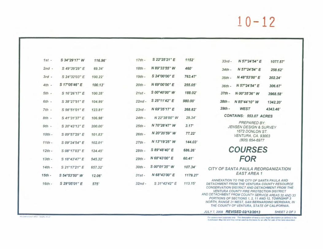
s u"æ'r7'w
s 19"3929- E
s 21"3203- E
s',7tr05'tt6'E
s 16"26',17'E
s 38"27'.51' E
s 56"5t'Ol- E
s 41"31',37' E
s 20"4:t'13'E
s 09"5729' E
s 09"21',N'E
s 08"17',03- E
s 18"43',17'E
s 21"1721' E
s 5a"A?'50'ty
s 29"05101'E
116.96',
69.31',
100.22',
1æ.13'
1æ.28'.
1U.99',
123.81'.
r06.98'
200.00'
101.83'.
102.01'
121.1'',
il5.32',
657.32',
12.06'.
57''.
s 2?25',21'E
N 89"33',55'W
s 210(n'ü)'E
N 89.û',û'E
s(nnut'(n'w
s 25'1112- E
N 69"35',r7' E
N 22"38Tn- W
N 70"2817'W
N 2o"m'59'W
N 13"19',25'W
S E9'48'¿10'E
N 68"tKt'(n'E
s (n"tt'35'w
N 6E"tçt'(n'E
s 31"13',12'E
1152',
180'.
7üt.a7'
255.0'',
188.02',
9æ.æ',
2æ.82'.
29.U'
3.t7',
77.22',
ttu.03'
6E6.26',
60.11',
107.9'
1r79.27'
113.15'
33rd- N57A'g'E 1077.57'
31th- N5721',9'E 2æ.62'
35ttr- NtSolËt'(n' E m2.21,
J6th- N8721'g'E æ6.0t'
37th - N ut 35,36. W 396E 5E.
38úr- NEû410'W 1g?.m,39¡h - lffESr 4343.1õ'
COtt/7ÁtfYS; SS1.OT ACRES
PREPARED BYJEIVSE/V OES'GA/ E SURYEY
1672 DONLON STVENTURA. CA.930',3
(æ5) 654-6977
COURSESFOR
CITY OF SANTA PAULA REORGANIZATIONEAST AREA 1
ANNEXATION TO THE C'TY OF SAA'TÁ PAULA ANDDETACHMENT FROM ÍHE VENÍURA COUNTY RESOURCECOT{SERYAT,OAJ O,STR,CT AA,D DEÍACHHENT FROM THE
WNTURA COUNTY NRE PROTECT'ON DISTRICTAND DETACHMENT FROM COUNTY SERY'CE AREÁS 32 AiVD 33
PORnOwS OF SECTTOIJS 1, 2, t ,, AND 12, fOWNSHtp 3NORÍH, RANGE 21 WEST, SA^' A€R'VARO'â{O TTER'DIAN, IN
ÍHE COUNTY OF VENÍURA, SÍATE OF CAUFORNIA.
JULY7.2æ8 RW\SED0ul2/ím13 SHEEr2o'F3¡Lv ¡¡Ðrñrru øt nn ûÞ¡-ndEdrd¡ tgt¡@Þ 6.bÍttJ ú Ir.f,ùtúr l¡p ¡dæ, ær tr. Þ ú u ñ ú b.t d* V * dÈ h¡d

10 L2a-
"t P.O.B. oz
') P3 {
.,oc
f-72E
27
{?
(/|
{*
ooo5 z äqn I
ro?
D15 RS 51\t vs t¡
G¡
266 zIvo¡
7
äqNOTE: sEE sHEEr 2 oF 3 FoR
COURSE VALUES2st
B I
ó.?È
alaE oR 292 a21
9PREPARED BY
JENS€A/ O€S/G^J E SIJRVEY1672 ooilto/v sr
VENTURA, CA 93003(805) 654-6977
22
s to s.P.ß'R'23
tlCITY OF SANTA PAULA REORGANIZATION
EAST AREA 1
ANNEXANON TO T'18 CITY OF SANTA PAULA ANODEÍACHMENÍ FRO*t ÍHE vfNrUR^ COUNTY RESOURC€CO,1'SERYAT'O'J O'STR'CT AHD DEf ACHMENT FRO*I THE
VENTURA COUNTY HRE PROTECÍION D'STR'CT
^ND DE'TACHMENÍ FROM COUNIY StsRY'CÈ ÁRE,AS 3? ANI) 33
POR¡,OI,JS OFSECflOTVS 1,2. tt AND l2,IOWNSHIP 3NORTIí, RÁIIGÊ 21 WEST, SÁAJ 8€R'VÁROINO MERIOIAN, IN
THE COUNTY OF VENÍURA, S TÄ TE OF CAUrcRMA
DETAIL ']B']
DETAIL J'A]' N. r.s.
ru. r.s
-
EX,ST,/VG CIIY OF SANTA PAULA aoUNDARYt2 r----.lb¡r¡¡J
PROPOSEO RE ORG AN' ZA NON BOIJNDA RY
JULY 7,2008 REVTSEO 0a1aínt3 SHEET 3 OF 3
'., ¡1tW a.4¡rr rñ,h.Èia¡r dh û rr ¡ agdr l".',"Ëy¡ a, lFt.¡,ò',,,d'æ l-' \t d ñ, ûrÞ ùd¡ h Þ a, - ot¡, þ -
d b ât ùtu,

10- 12CITY OF SANTA PAULA REORGANIZATION
EAST AREA IANNEXATION TO THE CITY OF SANTA PAULA AND DETACHMENT FROM THE
VENTURA COUNTY RESOURCE CONSERVATION DISTRICT AND DETACHMENTFROM THE VENTURA COUNTY FIRE PROTECTION DISTRICT AND
DETACHMENT FROM COUNTY SERVTCE AREAS 32 AND 33
Those portions of Sections l. 2, I I and 12, Township 3 North. Range 2l West. San BemardinoMeridian, in the County of Ventura, State of Calit'orniq as shown on thc Official Plat of said land.described as fbllows:
Beginning at thc northeast corner of Parcel 3 as shown on thc Parcel Map fìled in the Oflìcc of'theCounty Recorder ol'said County of Vcntura, in Book 37. Pages 2l-23, inclusivc. of Parccl Maps. saidcorncr also being the northe¡sterly terminus of the lTth coursc of thc Wilson Rcorganization.Annexation to the City of Santa Paula and Detachmcnt from the Ver¡tura County ResourccConscrvation District and Detachment from the Ventura County Fire Protection District. as describedand shown in the Ccrtificatc ol'Completion recordcd February I 8. 1983. in thc Otlice of said (ìountyRecordcr. in Documcnt No. 017273 of Oflicial Rccords; thcncc. along the boundary of said ParcelMap by the following l4 counies, and along thc cxisting boundary of'said City ol'Santa Paula by thcItrllowing 22 courses:
¡* South 34o29'l7" West, I ló.9ó f'ect; thencc.
2n,r South 4g"3g,Zg" East. ó9.34 tbct: thence.
3'd South 24"32'03" East. ttJO.22 fbct: thence.
4th South 17"05'46" Easl, 100.13 t'eet; thencc.
5th South ló"2ó'17" East, 100.28 fect; thence,
ó'h South 38o27'51 " East. lß.99 fecl: thencc.
7th South 5ó'51'0l" Easl, 123.81 t'eet: thencc,
8th South 4l '3 I '37" East. l0ó.98 fbet: thence.
9th South 20"43't3" 8as1,200.00 tbct: thencc.
lOth South 09o57'29" East. l0l .83 fcet; thencc,
I tth South 09"24'54" Easl, 102.01 fect: thencc.
l2'h South 08" l7'0-1" East. t 24.45 t'cct; thence.
l3th South 18o43'47" East. 545.32 tèct: thencc.
Pugc I ol .l
l(., LIM I 4 5l I Suncy'Erhrbltr, I.AFCO\.|S I I S¡ A Ànncrul¡tn.rllc

10- L2l4th South 21"17'2t " East, 657 .32 feet, at 62.72 feet thc mosr casterly corner of said Wilson
Reorganization, also being the most northerly corner of thc Say Road Reorganization. to thcCity of Santa Paula and Detachment from the Ventura Fire Protection District and VenturaCounty Resource Conssrvation District as describcd and shown in the Ccrtifrcate ofCompletion recorded November 7,2001 in Document No. 2001-02244ó5 of Official RcconJsof said county, at 657.32 feel the most easlerly corner of said Say Road Annexation; thcnccalong the southeasterly line of said Say Road Annexation,
l5'h South 54o53'50" West, 12.06 feet to the most northerty comer of the Tamayo Addition to thcCity of Santa Paula, as filed with the Secretary of State on April 10, 1987: thence along thcboundary of said Tamayo Addition by lhe following 3 courses,
I óth South 29o05'0 t " East, 575 feet, more or less: thence,
l Tth South 22"25'21" Easl, I 152 fsìet, more or less, lo the most easterly corncr ol'said TamayoAddition, being n point on the southerly line of said Section 2: thence along said southcrlyline,
l Sth North 89o33'55u Wesl, 460 f'cet, more or tess, to thc northwesterly corner of Lot I of saidSection I l; thence along the westerly line of said Lot I and existing boundary of thc City ofSanta Paula as incorporated by order of the Board of Su¡rcrvisors on April 22, 1902.
lgth South 24"00'00u East, 7ó3.47 t'eet to the northwestcrly comer of the Prcciotlo Reorganiz-ationto the City of Santa Paula from thc Ventura Fire Protection Districl and Ventura CountyResource Conservation District as described and shown in the Certiticatc of Complctionrecorded April I 8, I 98ó in Document No. 8ó-04ó05 I of Otf cial Records of said county:thence along thc boundary of said Preciado Reorganization by the following 3 courses.
20rh North ó9o00'00u East, 255.05 feet; thence,
2l'r South 00o40'00u West, I 88.02 feet; thence,
22"t South 25"1t'42" East,980.00 feet to the north tine of the Southern Pacitìc Railroad Right ol'\ilay, 100.00 feet widc; thence leaving said City of Santa Paula boundary along said northline.
23'd North ó9"35'¡ 7" East, 268.82 tèet to the most casterly corncr of the dcetl to Vcntura CountyFlood Control District recorded August 2, 1973 in Book 41 48, at Page 292 of Oflcial Records
of said county; lhence along the boundary of said Deed by the following 2 courses:
24'h
25th
North 22o38'00" lrly'est, 29.34 fc.et; thence,
North 70"28'47" West, 3.17 feet to the easterly linc of thc deed to Vcntura Clounty FloodControl District recorded Septcrnber 10, 1999 in Documcnt No. 9q-n4284 of OflicialRecords of said county; thence along said easterly line.
Pogc ! ol'4
K : I l.lM l.l J I |,Sunc1'.trhrbit-srl¡{FCO -l 5l I lir A Anner¡¡ irn.rÌr

.0- L2
26ú North 20o20'59" Wesl, 77.22 t'eet to the casterly line of the deed to Ventura Countyrecorded Dccernber I 8, 1928 in Book 23ó, at Page 3 I 7 of Official Records of saitlcounty: thence along last said easterly linc,
27th North I 3o I 9'25" rrly'est, I 44.03 fect to the north linc of Lot 2 ol'said Section I I as shownon the Record of Survcy Map filed in the Ofïìce of sairl County Rc'cordcr, in Book 15.
Page 5l of Records of Survey: thence. along said north line.
28th South 89o48'40" East. ó8ó.2ó feet to suid north linc of the Southern Pacific tìailroadRight of Way, 100.00 fcet widc; thence, along said north line,
29'h North 68"43'00" East, 60.41 feet to the northerly prolongation of the east line of FerrisCardens as shown on the Record of Survcy map fìled in the Oflce of said CountyRecorder, in Book 4, al Page 37 of Records of Survey; thence, along said prolongation.
.10th South 00"01'35" West, 107.-34 fcct to the south line of said Southc'rn Pacifìc RailroatlRight of Way. 100.00 t'eet widc: thence. along said south line,
31" North ó8"43'00" East, I 179.27 t'cct to the most westcrly comcr of Parccl I as describctl in
the deed rccordcd Novcmber 24, 1998, in Document No. 98-205985 of Otïicial Rccords
of said county; thencc, along the southwest linc of said Parcel I,
32n'f South 31"43'42" East, I 13.15 feet to the north line of Telegraph Road, ó0.00 fcct widc as
described in the deed to Ventura County recorded May 3. l9ló in Book I 50, at Pagc I 2 I
of Deeds of said county ; thence along said north line,
33"r North 5'1"24'54" East, I 077.57 t'eet to the north linc of said Southern Pacifìc Railnrad
Right of Way. 100.00 feet wide, at 25 I .50 t'eet the southwesterly terminus of the 9th
course of the H & H Oil Tool Annexation to the City of Santa Paula as described and
shown in thc Certificate of Complction recorded October 27, lg78 in Btxrk 5246, at Page
ó31 of Official Records of said county, at 750.00 feet the northeusterly terminus of said
9th course of the H & H Oil Tool Annexation; ther¡ce continuing along said north linc ofTelegraph Road (State Highway l2ó) by the following three courses:
34th North 57"24'54" East, 258.ó2 fect to the westcrly comer of the clced to thc State ofCalit'ornia recorded Septernbcr 21, 1953 in Book I 157, at Page 570 ol'Otlìcial Records ofsaid county; thcncc along the noflherly linc of the last said deerl by the lirllowing 2
courses,
35th North 48"53'00" East, 202.24 tbct; thence,
jófh North 57"24'54" East, 30ó.ó7 t'eet to thc east line of thc SW l/4 of the SW I /4 of saicl
Sc-ction I : thcnce along said east line to und along the esst line of the NW l/4 of thc SW
l/4 of said Scction I to and along the east linc of thc SW l/4 of the NW l/4 of saitl
Scction I,
i7'h North 00"35'3ó" East. -i9ó8.58 t'cct to thc northeast comer of saitl SV/ l/4 of the NW l/4
Prgc 3 of4
K LlMl.l5ll.Suncy Erhrbtts l.AfCO45ll lir A Annc¡¡¡lír¡nrhr

¿ 0- L2of Section I ; thence along the north line of said SW l/4 of the NW l/4 of Section l,
38th North 85o44'10" West, 1342.20 fea to northwest corncr of said SW l/4 of the NW l/4 ofSection l; thence along the north line of the SE l/4 of the NE l/4 of said Section 2, tourd along the north line of the SIV l/4 of the NE l/4 of s¡id Section 2, to and along thenorth line of the SE l/4 of the NW l/4 of said Section 2, to and along the north line ofLot I of the NW l/4 of said Section 2,
39th West, 4343.46 fect to the Point of Beginning.
Contains: 553.07 ac¡es, more or less.
For assessrnent purpos€s only. This description of land is not a legal description as defined in theSuMivision Map Act and may not be used as the basis for an offs for sale of the land described.
P4cl of ,l
K:ùlM l4l2 I \Survcy\Eih¡lit¡\LAFCO\45! I E¡ A AntE¡lion.&(