RSPO NEW PLAN TING PROCEDURES Summary … MKS-RSPO-NPP Template for Summary...Heru Bagus Pulunggono,...
23
Latest revision: 12 th May 2010 Page 1 of 23 RSPO NEW PLANTING PROCEDURES Summary Report of SEIA and HCV assessments 1. Executive Summary The area of PT Mitra Karya Sentosa (PT MKS) is located in Kampar Sebomban Village, Simpang Dua Subdistrict, Ketapang District, Province of West Kalimantan. The company was established in 2003 in line with the issuance of the area license in the name of PT MKS for oil palm plantation development purpose and its processing plant which issued by the Head of Ketapang District Decree No. 54 dated 19 February 2009, covering areas of 20,000 ha. PT MKS then received Minister of Forestry’s Decree No. 203/Menhut-II/2011 concerning releasing of the Convertible Production Forest Areas of 14,125.02 ha located in Semandang- Kualan Rivers Forest Areas, Simpang Dua Subdistrict, Ketapang District, Province of West Kalimantan. Final permit for PT MKS area was issued by National Land Agency through Decree of BPN No.94/HGU/BPN- RI/2013 for area 12,548.53 ha. PT MKS has legal environmental permit for it Environment Impact Assessment (EIA) from local government through Decree of Governor West Kalimatan No. 635/BLHD/2011 regarding Environmental Feasibility for Plantation (area 14,125.02 Ha) and Palm Oil Mill (Capacity 60 ton FFB/hour) for PT MKS at Simpang Dua SubDistrict, Ketapang District, West Kalimantan. To identify the existing condition of PT MKS particularly related to the community’s socio-economic, inter- relationship among stakeholders, land ownership and land status, land compensation and acquisition, impacts that may occur on the surrounding communities, and community’s perceptions towards the company, a Social Environmental Impact Assessment (SEIA) was carried out. PT MKS appointed Faculty of Forestry, Bogor Agricultural University (Fahutan IPB) to conduct SEIA study. There are 6 strategic issues identified including communities’ perceptions, tenure, labor, socio-economic, educational and public health and environmental issues. As required by RSPO, PT MKS engaged RSPO approved HCV assessment Faculty of Forestry, Bogor Agricultural University (Fahutan IPB) to carry out High Conservation Value of the proposed oil palm development area. The objectives of HCV identification are to identify the presence of the HCV area in PT MKS and to prepare HCV management and monitoring plan for PT MKS. There are 7 HCV identified in PT MKS area which are: HCV 1.1, HCV 1.2, HCV 3, HCV 4.1, HCV 4.2, HCV 4.3 and HCV 6. Based on HCV Assessment, the concession area comprise of secondary forest and shrub. Most of the land in the concession area belongs to local communities. 2. Scope of the SEIA and HCV Assessments: Table 1. Organizational information and contact persons Name of company PT. Mitra Karya Sentosa subsidiary of First Resources Ltd RSPO membership number 1-0047-08-000-00 belong to First Resources Ltd Location Kampar Sebomban Village, Simpang Dua SubDistrict, Ketapang District, West Kalimantan- Indonesia Administrative Address Corporate First Resources Office Regional Office APL Tower –Central Park, 28th Floor Podomoro City, Jl. Letjen. S.Parman Kav.28, Grogol-Petamburan, Jakarta, Indonesia Komplek Perdana Square Blok J 8 – 12, Jalan Perdana, Pontianak, West Kalimantan, Indonesia.
Transcript of RSPO NEW PLAN TING PROCEDURES Summary … MKS-RSPO-NPP Template for Summary...Heru Bagus Pulunggono,...

Latest revision: 12th May 2010 Page 1 of 23
RSPO NEW PLANTING PROCEDURES
Summary Report of SEIA and HCV assessments
1. Executive Summary
The area of PT Mitra Karya Sentosa (PT MKS) is located in Kampar Sebomban Village, Simpang Dua
Subdistrict, Ketapang District, Province of West Kalimantan. The company was established in 2003 in line
with the issuance of the area license in the name of PT MKS for oil palm plantation development purpose and
its processing plant which issued by the Head of Ketapang District Decree No. 54 dated 19 February 2009,
covering areas of 20,000 ha. PT MKS then received Minister of Forestry’s Decree No. 203/Menhut-II/2011
concerning releasing of the Convertible Production Forest Areas of 14,125.02 ha located in Semandang-
Kualan Rivers Forest Areas, Simpang Dua Subdistrict, Ketapang District, Province of West Kalimantan. Final
permit for PT MKS area was issued by National Land Agency through Decree of BPN No.94/HGU/BPN-
RI/2013 for area 12,548.53 ha.
PT MKS has legal environmental permit for it Environment Impact Assessment (EIA) from local government
through Decree of Governor West Kalimatan No. 635/BLHD/2011 regarding Environmental Feasibility for
Plantation (area 14,125.02 Ha) and Palm Oil Mill (Capacity 60 ton FFB/hour) for PT MKS at Simpang Dua
SubDistrict, Ketapang District, West Kalimantan.
To identify the existing condition of PT MKS particularly related to the community’s socio-economic, inter-
relationship among stakeholders, land ownership and land status, land compensation and acquisition,
impacts that may occur on the surrounding communities, and community’s perceptions towards the
company, a Social Environmental Impact Assessment (SEIA) was carried out. PT MKS appointed Faculty of
Forestry, Bogor Agricultural University (Fahutan IPB) to conduct SEIA study. There are 6 strategic issues
identified including communities’ perceptions, tenure, labor, socio-economic, educational and public health
and environmental issues.
As required by RSPO, PT MKS engaged RSPO approved HCV assessment Faculty of Forestry, Bogor
Agricultural University (Fahutan IPB) to carry out High Conservation Value of the proposed oil palm
development area. The objectives of HCV identification are to identify the presence of the HCV area in PT
MKS and to prepare HCV management and monitoring plan for PT MKS. There are 7 HCV identified in PT MKS
area which are: HCV 1.1, HCV 1.2, HCV 3, HCV 4.1, HCV 4.2, HCV 4.3 and HCV 6. Based on HCV Assessment, the
concession area comprise of secondary forest and shrub. Most of the land in the concession area belongs to
local communities.
2. Scope of the SEIA and HCV Assessments:
Table 1. Organizational information and contact persons
Name of company PT. Mitra Karya Sentosa subsidiary of First Resources Ltd
RSPO membership number 1-0047-08-000-00 belong to First Resources Ltd
Location Kampar Sebomban Village, Simpang Dua SubDistrict, Ketapang District, West
Kalimantan- Indonesia
Administrative Address
Corporate First Resources
Office
Regional Office
APL Tower –Central Park, 28th Floor Podomoro City,
Jl. Letjen. S.Parman Kav.28, Grogol-Petamburan, Jakarta, Indonesia
Komplek Perdana Square Blok J 8 – 12, Jalan Perdana, Pontianak, West
Kalimantan, Indonesia.

Latest revision: 12th May 2010 Page 2 of 23
Contact Person Corporate Sustainability Head – Bambang Dwi Laksono
Email Address: [email protected]
Geo Coordinate 00o49’36” – 00o56’06” S
110o06’54” – 111o22’50” E
No. Wajib Pajak/NPWP 02.080.783.4-701.001
Surrounding Area
• North Palm Oil Plantation
• South Palm Oil Plantation
• West Palm Oil Plantation
• East Forest and Community Land
Table 2 List of Legal documents, regulatory permits and property deeds related to the areas assessest
No Legal Documents Issued by Number and Date
1 Company establishment Notary: Petrus Yani
Sukardi, SH
Act No. 22
30 January 2003
2 Endorsement of company
establishment
Minister of Justice and
Human Rights
Decree of Minister of Justice and Human Rights
No. C-08018 HT.01.01.TH.2003
11 April 2003
3 Plantation Permit (Izin Usaha
Perkebunan)
District Head of Ketapang Decree of District Head of Ketapang No.
551.31/0632/DISBUN-C
1 April 2005
4 Location Permit District Head of Ketapang Decree of District Head of Ketapang No. 112
year 2005
27 April 2005
5 Extension of Location Permit District Head of Ketapang Decree of District Head of Ketapang No. 36 year
2008
25 January 2008
6 Location Permit
(Renew)
District Head of Ketapang Decree of District Head of Ketapang No. 54 year
2009
19 February 2009
7 Releasing of the Convertible
Production Forest Areas
Ministry of Forestry Minister of Forestry Decree No. 203/Menhut-
II/2011
11 April 2011
8 Environmental Feasibility
Approval for Plantation
Activities (AMDAL)
Governor of West
Kalimantan
Decree of Governor West Kalimatan No.
635/BLHD/2011
12 December 2011
9 Land Use Right (HGU) National Land Agency
( B P N )
Decree of BPN No.94/HGU/BPN-RI/2013
10 September 2013

Latest revision: 12th May 2010 Page 3 of 23
Figure 1 Location maps – both at landscape level and property level

Latest revision: 12th May 2010 Page 4 of 23
Figure 2 PT MKS surrounding and HCV area

Latest revision: 12th May 2010 Page 5 of 23
Figure 3 Land suitability PT MKS

Latest revision: 12th May 2010 Page 6 of 23
Figure 4 Area for new compensation program

Latest revision: 12th May 2010 Page 7 of 23
PT MKS proposed New Planting Area as its land use permit: 12,548.53 ha. New planting area planted > 2010 is
1,409.61 ha and no high conservation area being planted.
Table 3 Time plan for new planting
No Activity unit > 2010 2014 2015 2016 2017 2018 TOTAL
1 Planted Area ( Ha) 1,409.61
2 FPIC program (Ha) 1,937.09 1,923.57 2,014.87 2,034.53 1,896.39 9,806.45
3 Land Compensation Program (Ha) 1,876.77 1,903.44 2,204.33 1,987.48 1,834.43 9,806.45
4 Land Clearing Program
Nucleus (Ha) 1,518.05 1,481.65 1,576.11 1,787.41 1,481.94 7,845.16
Smallholders (Ha) 379.51 370.41 394.03 446.85 370.49 1,961.29
Total (Ha) 1,897.56 1,852.06 1,970.14 2,234.26 1,852.43 9,806.45
5 Nursery pcs 379,512 370,412 394,028 446,852 370,486 1,961,290
6 Plantable Area
Nucleus (Ha) 1,518.05 1,481.65 1,576.11 1,787.41 1,481.94 7,845.16
Smallholders (Ha) 379.51 370.41 394.03 446.85 370.49 1,961.29
Total (Ha) 1,897.56 1,852.06 1,970.14 2,234.26 1,852.43 9,806.45
During kadastral process, some area were being excluded from PT MKS location permit i.e. enclave for settlement
village area, small river riparian, Semandang riparian, Mount Laut forest area, Mount Seruing forest area, and peat.
Since the HCV identification area were using PT MKS’s 2011 Releasing of the Convertible Production Forest Areas,
the latest 2013 land use permit (HGU) has legally reduced HCV identified area. In 2012 total area for HCV is 2,627.99
ha of 14,125.02 ha; then in 2013 it reduced to 1.332,47 ha from 12,548.53 ha (see table 4). After reducing planted
and HCV area, total PT MKS plantable area is predicted 9,806.45 ha and will be develop in 5 years started from 2014
to 2018 (see table 3). To fulfill RSPO standard for Free Prior Informed Consent (FPIC) mechanism, PT MKS creating
FPIC program to whole plantable area. It will start from the nearest sub village (dusun) Lembawang then moving to
Tunas Kampar, Merangin, Mentawa Biring, Pantan then village Kampar Sebomban. Each FPIC program will be
followed by Land Compensation program for each individual who have land rights. Compensation program should
be done as PT MKS Standard Operational Procedure. All compensated area will be land cleared and planted at the
same year for both smallholder and nucleus area. Nursery will be built in PT MKS area from 2014.
3. Assessment process and procedures
Assessors and their credentials
The legal Social Environment Impact Assessment (AMDAL) was carried by:
PT Tiara Pilar Kreasi
Jl Sei Raya Komplek Mitra Indah Utama 3, Blok D3, Pontianak, West Kalimantan, Indonesia
Team Leader : Tri Rima Setyawati S.Si, M.Si
Physic and Chemical Aspect : Eta Fanani AR. S.Hut
Sarianto S.Si
Romiyanto S.Hut
Biological Aspect : Riyandi S.Si
Leonardus Silvester S.Si
Tri Astika Sari S.Si
Social and Economic and Cultural Aspect : Aris Bahariyono S.Si

Latest revision: 12th May 2010 Page 8 of 23
Public Health Aspect : Muhammad Adam S.Km
SEIA report was approved by West Kalimantan Governor through Decree of Governor West Kalimatan No.
635/BLHD/2011 dated 12 December 2011
The Social Environmental Impact of PT MKS was carried by:
Faculty of Forestry, Bogor Agriculture University
Bogor Agriculture University, Darmaga – Bogor, West Java Indonesia 16001;
Website: http://www.fahutan.ipb.ac.id/hcv/index.html
1. Dr. Ir. H. Nyoto Santoso, MS (Team leader).
He is a RSPO approved HCV Assessor with capacity as a Team Leader. His expertise is in Biodiversity
Management and Conservation, particularly: Mammals, Flora, Avifauna, Watershed Management,
Hydrology, Soil Conservation and competence in social aspect: Participatory Rural Assessment,
Participatory Mapping (GIS), Socio Culture and Conflict Resolution. Obtained his Master of Science degree in
Natural Resource Management and Environmental Study Program from Bogor Agriculture University (IPB)
in 1992, earning a Doctorate in Forestry Management Study Program (graduated 2012). As an expert of
environmental has been started since 1987. He is also as a lecture in Forest Resource Conservation and
Ecotourism Department, Faculty of Forestry, Bogor Agriculture University (IPB) with courses on ecology
and wildlife management, forestry and environmental policy, ecosystem management, ecological of
primates (primates and forestry management science - master's program at IPB). He had been an Executive
Director on Study and Development of Mangrove Indonesia (1996-2008), and currently listed as a Board
member of National Mangrove Experts, as well as members of the Expert Council of Sustainable Strategic
Plantations Development Forum.
2. Handian Purwawangsa, S.Hut, MS
Born at Cipanas, January, 1st 1979. He is a team member of SEIA at Faculty of Forestry Bogor Agriculture
University with competency on Social and Culture aspects. He obtained his Master degree of Forestry in
2008. Having experienced in social assessment since 2002.
3. Udi Kusdinar, S.Hut. As a team member of HCV and SEIA at Faculty of Forestry Bogor Agriculture University
with competency on Social and Culture aspects. Bachelor of Forestry in 2009 from Forest Resources
Conservation major study, Department of Forest Resources, Conservation and Ecotourism, Faculty of
Forestry, Bogor Agriculture University. Having experience in Social aspect since 2009.
4. Mustagfirin, S.Pi
Born at Demak, September 16th 1982. He is assistance for of SEIA at Faculty of Forestry Bogor Agriculture
University with competency on Social and Culture aspects. He obtained his Bachelor degree of Forestry in
2007 from Faculty of Fishery and Sea- Bogor Agriculture University.
5. Jimmy Syahrasyid
Born at Surabaya, November 19th 1976. He is free lance for of SEIA at Faculty of Forestry Bogor Agriculture
University with competency on Social and Culture aspects. His latest education was Kornita High School at
1996.
The Identification of High Conservation Value of PT MKS was carried by Forestry Faculty, IPB. Team member are:
1. Dr. Ir. H. Nyoto Santoso, MS
He is a RSPO approved HCV Assessor with capacity as a Team Leader. His expertise is in Biodiversity
Management and Conservation, particularly: Mammals, Flora, Avifauna, Watershed Management,
Hydrology, Soil Conservation and competence in social aspect: Participatory Rural Assessment,
Participatory Mapping (GIS), Socio Culture and Conflict Resolution.
2. Ir. Heru Bagus Pulunggono, MSi
Born at Banyuwangi, April 7th 1963. He is a team member of HCV at Faculty of Forestry Bogor Agriculture
University with competency on hydrology and soil conservation. He obtained Mater of Agriculture by
specific study Tropical Geography from Kyoto University, Japan. Experienced since 1999 in hydrology and
soil conservation. He is a lecture at Soil Science and Land Sources, Faculty of Agriculture, IPB.

Latest revision: 12th May 2010 Page 9 of 23
3. Eko Adhiyanto,S.Hut
Born in Batang, June 3rd 1978. He is a team member of HCV at Faculty of Forestry Bogor Agriculture
University with competency on flora. Obtained Bachelor of Forestry at major Forest Sources Conservation,
Ecotourism and Forest Sources Conservation Department IPB on 2001. Practicing his flora specialist activity
since 2003.
4. M. Sayidina Ali, Amd
RSPO approved HCV assessor with competences on Ecotourism and Flora, Participatory Mapping (GIS).
Obtained his Diploma of Forestry in 2005 from Ecotourism major study, Department of Forest Resources
Conservation and Ecotourism, Faculty of Forestry, Bogor Agriculture University. Having experience in
Mapping (GIS) since 2007.
5. Udi Kusdinar, S.Hut
Having competences on Socio Culture aspects.
6. Sutopo, S.Hut
As a team member of HCV at Faculty of Forestry, Bogor Agriculture University with competency on Wildlife
aspect. Obtained his Bachelor of Forestry in 2008 from Department of Forest Resources Conservation and
Ecotourism, Faculty of Forestry, Bogor Agriculture University. Having experience of first HCV study at Forest
Management Unit (KPH) Madiun – Perhutani (2007) focused on Wildlife aspect and essay title “Bird Species
Diversity In Several Types of Habitat at Forest Management Unit (KPH) Madiun – Perhutani Unit II East
Java”.
Assessment methods (Data sources, data collection, dates, program, places visited)
Assessment method for AMDAL
Impact assessment method used by AMDAL for PT MKS oil palm plantation and palm oil plantation was ‘Modified
Leopold Method’ which is combination between Leopold Matrix and Fisher and Davis Matrix added by weighting
scale for magnitude of Impact and Importance Impact. The example of modified leopold matrix is as table 4.
Table 4 Modified Leopold Matrix for PT MKS AMDAL method
No Environmental
component Affected
Component Activities Of Impact
Pre
Construction
Construction Operational
1 2 3 4 5 6 7 8 9 10 11 12 13 14
A Sub Component of Physics and Chemist Environmental
1 Quality of air and
noise level
List Of Activity :
Pre – Construction
1. Plan and
Socialization
2. Compensation land
Construction :
3. Employee
Recruitment
4. Heavy Vehicle and
construction
mobilization
5. Opening and
maintaining of land
2 Quality of air and
Hydro oceanography
3 Structure and soil
Composition
B Sub Component of Environment (Biotic)
1 Structure and Flora
Composition
2 Structure and
terrestrial Fauna
Composition
3 Structure and
aquatic biota
composition

Latest revision: 12th May 2010 Page 10 of 23
C Sub Component of Social, Culture, Economy and Public Health 6. Build of facilities
and infrastructure
7. Nursery and
planting of Palm Oil
8. Maintaining of
young plant
9. Opening of Palm Oil
Mill and supporting
facilities
After Construction :
10. Employee
recruitment
11. Maintaining mature
plant
12. Harvesting and
Transport FFB to
palm oil mill
13. CPO and PKO
Distribution
1 Public Perception
2 Job and business
Opportunity
3 Public Income
4 Public Welfare
5 Level of Health and
Environmental
sanitation
Data related to AMDAL SEIA analysis are BPS Ketapang in number 2011, BPS Ketapang for Simpang Dua Sub District
in number 2011, and Indonesian NI for RSPO 2008. Framework approach used in the Social Environment Impact
Assessment (SEIA) is to identify the current state (existing condition) of PT. MKS particularly related to the
community’s socio-economic, inter-relationship among stakeholders, land ownership and land status, land
compensation and acquisition, impacts that may occur on the surrounding communities, community’s perceptions
towards the company. Based on the existing condition, the SEIA document was then compiled containing
characteristics of the surrounding communities, issues/problems raised and the settlement efforts undertaken,
inter-relationship among stakeholders, impacts both positive and negative which generated on the surrounding
communities and the corporate social management plan.
The study utilizes purposive sampling and simple random sampling. In the purposive sampling, samples were
determined based on researchers’ assessment which considered as the most appropriate samples to fulfill required
data. While simple random sampling utilized to give equal opportunities to be taken to every element of the
population. The study utilizes purposive sampling to determine village samples. It also uses simple random sampling
to determine respondents in the selected villages. Village samples are determined based on its accessibilities,
community characteristics, social insecurity and inputs from the PT. MKS. Then the village of Kampar Sebomban,
Simpang Dua Subdistrict, Ketapang District was determined as sample village. Sample distributions were determined
by considering representation of the population based on the characteristics of existing population.
Primary and secondary data collected, then analyzed using combination of quantitative and qualitative methods.
Qualitative analysis will be more emphasized on the description of facts and relationships among variables found in
the field. Based on the description and the relationship among existing variables, then followed with analysis of
1) The local community’s socio economic within and around the company’s area,
2) Analysis of farmers and the public's perception towards the company, and
3) Analysis of the impacts generated by the company of PT. MKS on the environment, and community’s socio-
economic-culture.
The results of the analysis were then synthesized in the form of Social Impact Assessment document and Corporate

Latest revision: 12th May 2010 Page 11 of 23
Social Management Plan of PT. MKS.
Figure 3 Framework approach for SEIA of PT MKS
The study was carried out in the area of PT MKS and the surrounding villages which administratively located in
Kampar Sebomban Village, Simpang Dua District, Ketapang Regency, Province of West Kalimantan and conducted
from 20 – 24 February 2012.
HCV
Data sources as Toolkit for Identification of High Conservation Values in Indonesia by Consortium to Revise the
HCV Toolkit for Indonesia JAKARTA - June 2008 are satellite imagery; topography and slope maps; map of Forest
Land Use Consensus Plan; Land System map; river network map, Field Giude Books ((Field Guide Book for birds in
Sumatera, Kalimantan, Jawa and Bali - BirdLife, Mammals and Reptiles in Sumatera, Kalimantan, Jawa and Bali);
Social and Cultural Questionnaires, and field book.
The success of the HCV study will depend on two factors, namely:
(1) the availability of adequate and the latest data of, both secondary and primary data and
(2) proper and systematic activity steps.
Availability of adequate and latest data/information will depend on the systematic, adequate and well-planned of
field surveys carried out. In order to conduct an expected field survey plan, then the review on the exisiting
documents / reports / maps and initial HCVs identification need to be conducted. While the proper and systematic
activity steps, include field surveys, data processing, analysis and synthesis of data, identification and analysis of the
HCV presence and mapping.

Latest revision: 12th May 2010 Page 12 of 23
Figure 4 Framework approach for HCV of PT MKS
Physical Conditions
Types of land cover in the area of PT MKS consist of secondary swamp forests, low land secondary forests, shrub,
mixed crops farming fields, bare lands and settlement. While types of land cover on areas around PT MKS are
secondary swamp forests, low land secondary forests, oil palm plantation, settlement and mixed crops farming
fields.
Biological Conditions
Flora
There are 2 plant species found as protected species under PP No 7/1999, 7 plant species which identified as
species of Appendix II CITES and 30 plant species which identified as species of Red List IUCN containing 7 species
of CR/Critically Endangered, 2 species of EN/Endangered, 4 species of VU/Vulnerable, 17 species of LR/Low Risk, 1
species of LC/Least Concern and 3 species of DD/Data Deficient.
Wildlife
There are 31 wildlife species found as protected species under PP No 7/1999 containing 14 species of mammals, 16
species of aves and 1 species of reptile. Also, 24 wildlife species are found as species of CITES Appendixes
containing 7 species of Appendix I (5 species of mammals, 1 species of aves and 1 species of reptile); 16 species of
Appendix II ( 7 species of mammals, 6 species of aves and 3 species of reptiles); and 1 species od Appendix III ( a
species of mammal). Almost all of the wildlife species found, except 3 species of reptiles, are identified as the
species of IUCN Red List which containing 5 species of EN/Endangered (4 species of mammals and 1 species of
reptile), 8 species of VU/Vulnerable (8 species of mammals), 11 species of NT/Near Threatened (2 species of
mammals and 9 species of aves), 1 species of DD/data deficient mammal) and others are species of LC/Least
Concern.

Latest revision: 12th May 2010 Page 13 of 23
Environmental Services Aspects
Areas or ecosystems important for the provision of water and Prevention of Floods for Downstream Communities.
According to the field observation and satellite imagery interpretation, it is showed that types of ecosystems
contained in the area of PT MKS consist of low land ecosystem (riparian ecosystem) and peat swampy ecosystem in
the form of logged over secondary forest areas.
Ecosystem Impotant Related to The Various Land Class Based on The RePPProT
According to the RePPProT data of 1987, it is identified that types of land system in the area of PT MKS which
consisting of GBT (Peat), MDW (mendawai), RKG (Rangkankau), PLN (Pakulanai) and TWI (Telawai). RGK and GBT
land systems are important ecosystems in Kalimantan Island and rare ecosystems in the area of PT MKS.
Soil Erosion
The soil erosion hazard level will depend on the soil conservation and plantation management practices
implemented. When the plantation is well managed under the best management practices on soil and water
conservation, for instance: planting legumes as cover crops; developing guludan as plant strenghtener; developing
embankment of waterway and canals either mechanically or by planting particular plants like vetiver grass or
scented citronella; and water management as developing drainage system like rorak-rorak ; application of mulsa
using stems and empty bunches of palms, then the erosion will be very low to low (0.89 – 29.27 tons/ha/year).
Otherwise, the worse the management by ignoring best conservation and water practices management, the larger
the erosion level as indicated by medium plantation management and conservation, then the erosion value will
range from very low to medium (4.46– 146.33 tons / ha / year). When the plantation area is managed under poor
plantation management and conservation, then the erosion will range from medium – very heavy (22.32 – 731.64
tons / ha / year).
Socio Economic and Culture Aspects
Main of livelihoods peoples in Kampar Sebomban village for the basic need as a farmer/rubber workers. Peoples in
this village is sub-sisten; more of them has agriculture in dry land or swamp. The dry land agriculture is conducting
for them self family and agriculture products is not sell. The other of livelihoods are sailors, hunter, workers
(farmer, builder, daily), un permanent worker, service sell, forest yield collecting and marketing.
Stakeholder consultation (stakeholders contacted, consultation notices and dates)
Social Environment Impact Assessment (AMDAL) first public consultation was held on 1 February 2011 at Dusun
Lembawang, Kampar Sebomban Village, Simpang Dua Sub District, Ketapang District, West Kalimantan, Indonesia.
Stakeholder contacted via public notification at Village Office and invitation for indigenous people. There were 30
participants. Second AMDAL public consultation was held on 28 October 2011 at Simpang Dua Sub District Office,
Ketapang, West Kalimantan, Indonesia. Stakeholder contacted via public notification at Sub District office and all
village office in Simpang Dua Sub District area. There were 33 participants from government, local people, university
and local organization.
In this study, stakeholder identification was focused on the parties related to the management plan of PT. MKS at
local/ site level. And in the study, it was identified 14 stakeholders which containing government agencies,
company’s management and communities. Each group of stakeholders have different relevance to the existing socio-
economic problems in the surrounding area of PT. MKS. The main stakeholders who directly drive the plantation of
PT MKS are the company’s management and community. While other stakeholders who indirectly affect the
plantation are the local government.
Stakeholders associated with PT. MKS can be classified into three groups, namely direct primary stakeholders i.e.
stakeholders who receive benefits directly from the PT. MKS, indirect primary stakeholders i.e. stakeholders who
receive indirect benefits from PT. MKS and secondary stakeholders i.e. stakeholders who are not included in groups
1 and 2, but have interests towards PT. MKS.
Direct primary stakeholders are the stakeholders who are at the level of internal corporate and local level, for
example : company’s employees / workers, or other parties who are directly benefited from the company (income
and other facilities according to their level). Policies of the PT. MKS will be very influential on these stakeholders.
Village and dusun governments, are also included in the direct primary stakeholders of PT MKS. Those stakeholders

Latest revision: 12th May 2010 Page 14 of 23
received directly benefits from the company in the form of social reliefs and employment opportunities for local
communities. While stakeholder that included in the indirect primary stakeholder is the Local Government of
Ketapang Regency and Simpang Dua District.
Stakeholder that included in the secondary stakeholders is Badan Lingkungan Hidup of Ketapang Regency. Those
stakeholders receive interests towards the company especially related to the implementation of sustainable natural
resources management, conducive situation and the compliance with the all applicable regulations.
Stakeholder consultation for HCV Identification was held together with SEI Assessment.
List of Legal, regulatory and other guidance referenced.
• refer to table 2
• Term of Reference of Environmental Impact Assessment (KA ANDAL) PT MKS
• Environment Management and Monitoring Program (RKL RPL) PT MKS
• Toolkit for Identification of High Conservation Values in Indonesia by Consortium to Revise the HCV
Toolkit for Indonesia JAKARTA - June 2008.
• satellite imagery
• topography and slope maps;
• map of Forest Land Use Consensus Plan;
• Land System map;
• river network map,
• Field Guide Books ((Field Guide Book for birds in Sumatera, Kalimantan, Jawa and Bali - BirdLife, Mammals
and Reptiles in Sumatera, Kalimantan, Jawa and Bali);
• Social and Cultural Questionnaires
4a. Summary of assessment findings (for SEI assessments)
Summary of key findings in respect of socio-economic impacts to country, region and local communities.
AMDAL findings
• PT MKS is environmentally and socially feasible.
• PT MKS need to conserve some area from its location permit.
• PT MKS need to enclave some area for people’s settlement.
• PT MKS need to follow environment management and monitoring plan so effluent and emission of it
activities will not against government’s environmental quality standards.
• PT MKS need to follow social management plan to avoid social disturbance.
SEIA findings
Kampar Sebomban is a village which intensely interacted with the company of PT MKS. Most of the village
community are Catholics and Moslems. While based on their origin, the village community are the members of
Dayak Simpang Tribe, Melayu and others (Jawa, Bugis and China). Most of the village community’s livelihoods are
field farming and rubber crop farming. Lack of educational and public health
facilities.
Forested areas and other natural ecosystems within the area of PT MKS are utilized by the village community of
Kampar Sebomban to meet their needs for animal protein (meats and fish), vegetables and fruits, wood as materials
for housing, furnitures and firewoods, animal feeds in less than 50% or with the scoring values 0, 1 and 2. It
indicates that the existing forested areas and other natural ecosystems within the company area were considered
as less important for the village community of Kampar Sebomban in meeting their basic needs. Most of the
community’s basic needs are met from outside the company’s area such as purchase, community’s own cultivation
and reliefs.
The existing potentials in the Kampar Sebomban Village are land availabilities and the development of rubber crops
plantation, fresh fish culture, rattan, honey and bauxite mining.
The most Corporate Social responsibility (CSR) programs required by the village community are in the form of
providing clean water supply facilities, educational facilities supports (scholarship, teacher’s assistants, school

Latest revision: 12th May 2010 Page 15 of 23
buildings), lighting / eletrical supply support and public health services (medical workers and medicines), training
and technical assistance on rice field farming, vegetables cultivation and raising livestock, actualization of plasma
scheme, training and development of entrepreneurship and community’s skills
The social programs undertaken by the company of PT MKS are village land roads improvements, providing electric
generator, providing artesian well, supports of the needs for heavy equipments, supports of patients
transportations and financial supports on the national holidays and religious
Summary of key findings in respect of socio-economic impact in respect of emergent communities (workers,
suppliers, etc.).
Risk Factors Analysis
Risk factors identified in the initial phase of PT MKS plantation development are land certainty and business
legality, local community’s legitimacy, labor supply, horizontal conflict, household economic resistance, public food
supply, social dynamic and local community’s welfare
Positive Impacts
According to interview, it was estimated that a palm plantation development of PT MKS will deliver positive
impacts on the surrounding communities in the form of employment and business opportunities for local
communities, become crowded on the surrounding villages, better village accessibility and infrastructures.
Negative Impacts
Based on interview result with PT. MKS's existence society peaceful Opus hasn’t caused negative impact. Besides
positive impact potency, existence of PT MKS partner also give negative impact potency. Negative impact potency
that for example: qualities changed potency opening consequent river water farm and chemical material purpose or
manure, surface soil erosion, increasing it dust, social conflict, its dwindling is location hunts and location look for
to usufruct forest etcetera.
Issues raised by stakeholders and assessors comments on each issue. Communities Perceptions
According to the interviews and FGD, it was revealed that the village community of Dusun Lembawang showed
their acceptance towards the company’s presence. While the village community of Dusun Tunas kampar showed
their acceptance towards the company’s presence under some certain conditions. The village community of Dusun
Merangin have not shown their acceptance.
Tenure Issues
According to the FGD, it was revealed the issues related to the tenure : 1) The intense custom rules applicable in a
land problem settlement, 2) the existing custom institution is not fully able to control land problems, 3) There is no
formal reference in the custom penalties, 4) Most of the village community are willing to hand over their land to the
company due to the lack of information and communication, 5) land acquisition by local investors (speculators), 6)
Individual land ownerships are evenly distributed, 7) Decision on a land utilization is a personal decision not a
communal decision, 8) Officialy, a dusun showed their rejection to join in the company but some village community
have shown their interests to join, 9) Average of land ownership in the village is around 30 ha/household.
Labor Issues
According to the FGD, it was revealed the issues related to the labor :
1) Most of the community’s livelihoods are field farming and rubber crop farming,
2) Income of tapping rubber is greater than the company’s wage standard,
3) village community’s work culture.
Socio Economic Issues
Strategic issues arised related to the socio economic in the surrounding communtie are 1) Intense custom rules are
applicable in a land problem settlement, the existing custom institution is not fully able to control land problems
related to the land utilization, 2) Custom rules are applicable in a community’s problem settlement such as
community’s conflicts, theft etc, 3) evenly distribution of local power to the chief of a dusun, custom institution,
informal leaders and local investors, 4) local economy is controlled only by some rubber traders, 5) local economy
depends on the rubber trading, 6) It is easy for the village community to earn money over Rp 5 million.
Educational and Public Health Issues
According to the FGD, it was revealed the issues related to public education and health are 1) Lack of educational
facilities (only elementary eschool), 2) Some of the village are graduated from university or even post graduated

Latest revision: 12th May 2010 Page 16 of 23
who have considerable influence in building public perception towards the company, 3) It is not provided with
adequate community’s education level, in increasing the community’s participations to the company’s activities.
Environmental Issues
According to the FGD, it was revealed that almost all of the village communities have not known the negative
impacts that will be generated by the company’s presence on the environment such as water pollution, ground
water availability, air pollution due to dust and smell, and damage to roads.
4b. Summary of assessment findings (For HCV assessments) Overall HCV identification and proposed measures to maintain and enhance those identified Documentation
showing the Obtained Free, Prior and Informed Consent of any indigenous peoples affected by the
development of the concession (part of RSPO requirements)
Data sources and quality According to the 11 (eleven) years long observation on rainfall (2000-2010) at the Meteorology and Geophysics
Station (BMG) Ketapang, climate in the area of PT. MKS is characterized Climate Type B (wet), Schmidt-Ferguson
Classification- 1951, containing 8 wet months, 2 humid months and 2 dry months with Q value of 0.25 (comparison
between dry months – average monthly < 60 mm, and wet months – average monthly rainfall >100 mm. Dry
months usually happen in the period of July and August, while the humid months happen in the months of June and
September.Average yearly rainfall in the area of PT MKS is around 2,354 mm and it indicates that the area is
suitable for oil palm plantation development purpose.
The company’s area is located at the altitude ranging between 4-453 m above sea level with the land slope varies
between flat to declivous (0- > 40%). Most of the area is flat with the land slope between 0-5 %.
According to the Geological Map, the Pontianak/Nangataman Quadratngle, scale 1 : 250,000 published by
Geological Research and Development Center, Bandung, 1993, it is showed that the company area is composed of 3
geological formations namely : (1) Aluvium sediment, coast, lake, swamp and undak (Qa) containing mud, sand,
gravel, and plant materials (peat), covering less than 50% of the company area and distributed at the western and
southern part of the company area, (2) Gununga pi Kerabai stones (Kuk) which composed of andesite lava, dacite
and basalt, breccias lava, pyroclastic and small intrusions, covering less than 30% of the company area and
distributed at the northern and eastern part of the company area, (3) Sukadana Granite (Kus) which composed of
monzogranit, syenogranit, monzonit kuarsa, syenit kuarsa, granit feldspar alkali, and a bit of granodiorite, tonalit,
and quartz diorite, Rocks contain biotite and varied hornblende, and sometimes of klinopiroksen and amfibol alkali,
covering less than 20% of the company area and distributed
at the eastern part of the company area.
According to the land system map, the soil review map, scale 1 : 250,000 ((RePPProT, 1990) and he field
observation, the company area are composed of 7 (seven) soil types namely: Tropofibrist (Organosol Fibrik),
Tropohemists (Organosol Hemik), Tropaquepts (Gleisol and Kambisol), Dystropepts (Kambisol Distrik), Tropudult
(Podsolik), Paleudults (Podsolik Kromik), and Haplorthox (Oksisol).
The company area is located in the Kapuas Hilir sub watershed area with the main river flowing inside is
Semandang River and its tributaries (S. Tamiang, S. Tentunyuk, S. Sorie, S. Tunduh, S. Yeh Tatin, S. Pelapis, and S.
Dadap)..
According to Forest Areas and Aquatic Designation Map of West Kalimantan Province, scale 1 : 250.000 (the Decree
No 259/Kpts-II/2000), land status of the area of PT MKS is Convertible Production Forest areas. Then it was
released in 2011 through the Decree of Minister of Forestry No SK.203/Menhut-II/2011 covering areas of
14,125.02 ha. While according to the Spatial Planning of West Kalimantan Province, land status of the company
area is Convertible Production Forest and Dryland Farming Areas.
Which HCV toolkits employed
Toolkit for Identification of High Conservation Values in Indonesia by Consortium to Revise the HCV Toolkit for
Indonesia JAKARTA - June 2008
Decisions on HCV status and related mapping

Latest revision: 12th May 2010 Page 17 of 23
Table 5 The Results of Identification and Analysis of HCV 1-6’s Presence in The Area of PT. MKS
HCV / Component HCV Presence
HCV Area 2012
2013
HCV1. Areas with important levels of biodiversity
HCV1.1. Areas that contain or provide biodiversity support functions to protection or conservation areas
Present - Bufer zones of Gunung Seriung Protection Forest
459,56
0
- Bufer zones of Gunung Laut
Protection Forest
332,69
0
HCV1.2. Critically endangered species
Present - Riparian of Semandang River 214,16 0 - Deep Peat Land > 3 m 1.167,4 965.70 - Bufer zones of Gunung Seriung
Protection Forest
*)
*)
- Bufer zones of Gunung Laut Protection Forest
*)
*)
HCV 1.3. Areas that contain habitat for vilable population of endangered, Restricted range or protected
Absent -
HCV1.4. Areas that contain habitat of temporary use of species or congregations of species
Absent -
HCV2. Natural Landscape and Dinamics
-
HCV 2.1. Large natural landscape with capacity to maintain natural ecological processes and Dinamics
Absent
-
HCV 2.2.Areas that contain two or more contiguous ecosystems)
Absent
-
HCV2.3. Areas that contain representatives population of most naturally occuring species
Absent
-
HCV3.Rare or endangered ecosystem
Present - Deep Peat Land > 3 m *) *)
HCV4. Environmental Services
HCV4.1. Areas or ecosystems important for the provision of water and and Prevention of Floods for Downstream Communities
Present - Riparian of Semandang River *) *) - Riparian of Empawang 97,1 97,1 - Riparian of S.Pelapis, S.Dadap 110, 74,02 - Riparian of Tanduh 71,8 46,73 - Riparian of Temiang 11,8 9,15 - Riparian of Paku 119, 106,14 - Riparian of Tentunyuk 31,1 27,80 - Riparian of Sorie 12,6 5,83
- Deep Peat land >3 m *) *)
HCV4.2. Areas important for the prevention of erosion and
sedimentation
Present - Bufer zones of Gunung Seriung Protection Forest
*) 0
- Bufer zones of Gunung Laut Protection Forest
*) 0
HCV4.3. Areas that function as natural barriers to the spread of forest or ground fire
Present - Bufer zones of Gunung Seriung Protection Forest
*) 0
- Bufer zones of Gunung Laut Protection Forest
*) 0
HCV5. Natural areas critical for Meeting the basic needs of local people
Absent

Latest revision: 12th May 2010 Page 18 of 23
HCV6. Areas critical for maintaining the cultural identity of local communities
Present Merangin Scared River. Prohibition of fishing from the upstream of Merangin River to the intersection of Merangin River – Dadap River.
Sacred Tengang, Hutan Raja Ali.
Kayu belian that has been fallen.
Roots lifted up and budding
grows. In the right side of
Semandang River.
Sacred Tunas Kampar which in the form of 2 “Belian Trees” on the. Aik Putih River (tributaries of Paku River), behind Rodi’s House as. a place for people putting “sesaji”
Old Kampong and tembawang Mentawabiring. An ex betang house which abandoned in 1985 due to no clean water as an impact of HPH Hutan Raya’s activities.
Ancestral Tomb Mentawa Biring. It is still used by the community.
Sacred Tarojun Konakng. In the form of water fall of. Sorie River.
Sacred Tama’ Galung. In the form of an old tomb. It was not used anymore.
Sacred Dadap. In the form of ponti and stone covered with bamboo. There are big tengkawang and kayu ara trees.
An old kampong and tembawang Dadap. There are 3 ex betang houses. Village peoples moved to Kampong Merangin in the Dutch era in 1947.
An old tomb of Mak Ripang’s father (a community’s elder of Kampong Merangin), marked by 3 durian trees.
Sandung Orang Buko. In the form of
kayu ara (Ficus sp.). Peak point of
the hill. Buko people inhabit
Dadap before Dayak people from
Sukadana coming
Sacred Tarojun Merangin. In the form of water fall. A place for people putting “sesaji”.
Sacred Ponti (wood statue) Pengaduh Pengingki, and white small stone. Kek Patih Jogam. A place for people praying and requesting something.
An old tomb ("market") Tama' Sebomban. Has been utilzed. Containing big trees inserted by rattan and bamboo.
Sacred Sekawan. In the form a stone in the upstream of Sekawan River located within protection forest area
Total of HCVA 2.627,9 1,332.4COMPANY’s AREA 14.125, 12,548.% of HCVA 18,61 10,62

Latest revision: 12th May 2010 Page 19 of 23
Note :
*) = The extent is the same as mentioned above.
During HCV identification in February 2012, highest legal permit for PT MKS is Minister of Forestry Decree No.
203/Menhut-II/2011 regarding Releasing of the Convertible Production Forest Areas for PT MKS dated 11 April
2011. Assessor used the area 14,125.02 ha from it to identify HCV area. In 2013 after the issuance of Decree of BPN
No.94/HGU/BPN-RI/2013 dated 10 September 2013 regarding land use title for PT MKS, some area being excluded
from PT MKS. The area are enclave for settlement village area, small river riparian, Semandang riparian, Mount Laut
forest area, Mount Seruing forest area, and peat. The comparison of HCV area can be seen on table 5.
HCV management will be held for HCV area inside PT MKS land use permit. Otherwise monitoring of HCV area will be
held for all area that identified earlier by the HCV assessor, although it already being excluded from PT MKS land use
permit.

Latest revision: 12th May 2010 Page 20 of 23
Figure 5 Identified HCV area base on assessor report 2012
Latest revision: 12th May 2010 Page 21 of 23
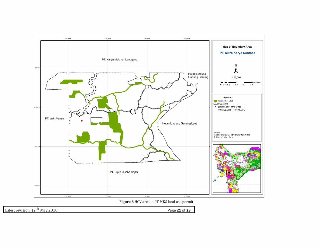
Figure 6 HCV area in PT MKS land use permit

Latest revision: 12th May 2010 Page 22 of 23
5. Internal responsibility
Formal signing off by assessors and company Statement of acceptance of responsibility for assessments.
.
Latest revision: 12th May 2010 Page 23 of 23