How do oil spills impact Casco Bay? 3 - Muskie School of...
8
Casco Bay Estuary Partnership 23 Background S pilled oil threatens many types of coastal habitat areas, including sheltered beaches where there is little wave action to disperse spilled oil, tidal flats where oil may seep into the muddy sediments, and salt marsh areas where oil may damage sensitive root systems. Animals and plants can be impacted by direct physical contact with the oil. For example, filter- feeding shellfish and bird eggs can be smothered by oil. The feathers of birds or the fur of seals lose their insulating properties when coated with oil, leading to the danger of death from cold. Birds can also drown when their feathers become matted with oil. Oil can destroy food resources, directly killing prey species and also tainting the way they taste and smell and making them unacceptable as food. If ingested, oil can damage the digestive system. Oil vapors have the potential to damage the nervous system of ani- mals, as well as damaging their lungs and liver. The more volatile components of oil may evaporate rap- idly, leaving the heavier components of crude oil, such as PAHs, to persist longer in the environment. These persistent toxic chemicals have the potential to cause more subtle, long-term effects such as reproductive problems in birds (US EPA 1999). Benthic invertebrates exposed long-term to elevated levels of PAHs in the sediments may experience impacts including inhibited reproduction and death (US EPA 2005). For fish, expo- sure to polluted sediments containing multiple toxins including PAHs can result in cancerous lesions, fin ero- sion, liver abnormalities, reproductive problems, cata- racts and suppression of the immune system (Fabacher et al. 1991; Weeks and Warinner 1984, 1986; O’Conner and Huggett 1988; Nicolas 1999). 3 How do oil spills impact Casco Bay? Birds can drown when their feathers are matted with oil after a serious spill. USF&WS Oil spreading up the Fore River from the Julie N oil tanker spill in September, 1996. Maine DMR
Transcript of How do oil spills impact Casco Bay? 3 - Muskie School of...

Casco Bay Estuary Partnership 23
Background
Spilled oil threatens many types of coastal habitat areas, including sheltered beaches where there is little wave action to disperse spilled oil, tidal
flats where oil may seep into the muddy sediments, and salt marsh areas where oil may damage sensitive root systems. Animals and plants can be impacted by direct physical contact with the oil. For example, filter-feeding shellfish and bird eggs can be smothered by oil. The feathers of birds or the fur of seals lose their insulating properties when coated with oil, leading to the danger of death from cold. Birds can also drown when their feathers become matted with oil. Oil can destroy food resources, directly killing prey species and also tainting the way they taste and smell and making them unacceptable as food. If ingested, oil can damage the digestive system. Oil vapors have the potential to damage the nervous system of ani-mals, as well as damaging their lungs and liver.
The more volatile components of oil may evaporate rap-idly, leaving the heavier components of crude oil, such as PAHs, to persist longer in the environment. These persistent toxic chemicals have the potential to cause more subtle, long-term effects such as reproductive problems in birds (US EPA 1999). Benthic invertebrates exposed long-term to elevated levels of PAHs in the sediments may experience impacts including inhibited reproduction and death (US EPA 2005). For fish, expo-
sure to polluted sediments containing multiple toxins including PAHs can result in cancerous lesions, fin ero-sion, liver abnormalities, reproductive problems, cata-racts and suppression of the immune system (Fabacher et al. 1991; Weeks and Warinner 1984, 1986; O’Conner and Huggett 1988; Nicolas 1999).
3How do oil spills impact Casco Bay?
Birds can drown when their feathers are matted with oil after a serious spill.
US
F&
WS
Oil spreading up the Fore River from the Julie N oil tanker spill in September, 1996. Mai
ne D
MR
24 Toxic Pollution in Casco Bay: Sources and Impacts
Factors that Affect the Severity of Oil SpillsPolycyclic aromatic hydrocarbons (PAHs), are the most widespead toxic pollutants in Casco Bay (CBEP 1996). They are found in fossil fuels and can enter the Bay directly when oil is spilled into marine waters. Oil, whether in the form of crude, unrefined oil, or fuel oil tends to spread horizontally into a slick on the surface of water. The sur-face tension, specific gravity, and viscosity of the particular type of oil spilled affect the ability of the oil to spread.
Surface tension refers to the degree of attraction between the surface molecules in a liquid. This attraction is decreased by heat so oil spreads more rapidly in warmer weather.
Specific gravity refers to the density of a substance in comparison to water. Since oil has a lower specific gravity than water, it floats in the surface, where it can be spread by wind and currents. As the lighter compo-nents of oil evaporate, leaving the heavier substances, oils and tars may sink and coat rocks and sediments on the bottom.
Viscosity refers to the thickness or resistance to flow of a liquid. The more viscous or thicker the oil, the less likely it is to spread (US EPA 1999).
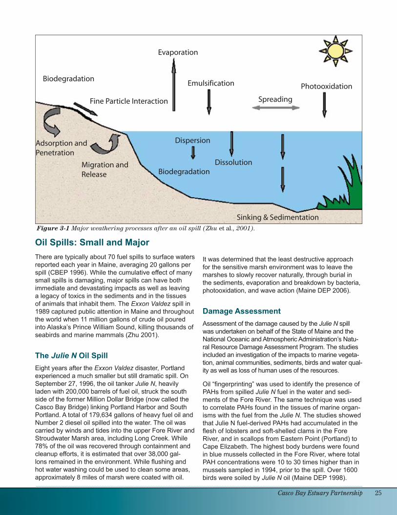
Weathering of Spilled OilThe severity of an oil spill is also affected by natural environmental processes (weathering).These chemical, physical, and biological processes are illustrated in figure 3-1 (Zhu et al. 2001). In addition to spreading oil over the water surface, which is influenced by viscosity and surface tension as discussed above, weathering includes processes of dispersion, emulsification, evaporation, photooxidation and biodegradation.
Dispersion: When the water column is agitated, oil can break into droplets that are dispersed throughout the water column (US EPA 1999). Also, interaction of the oil with fine (micron-sized) particles on the surface can reduce its adhesion to sediments or rocks, resulting in the formation of oil droplets that disperse into the water column (Owens 1999).
Emulsification: Waves can further disperse oil droplets into an emulsion, a thick, sticky mixture of water trapped in viscous oil that can linger in the environment for years (US EPA 1999).
Evaporation is the most significant weathering process right after a spill occurs, removing the volatile substances in the oil mixture. For crude oil, this can include 20-50% of the oil spilled. For Number 2 fuel oil, the volatile components may be about 75% of the oil mixture. Gasoline and kerosene are made up 100% of volatile components.
Photooxidation occurs when sunlight transforms complex high molecular weight petroleum compounds into simpler compounds which are more soluble in water and potentially more available to vulnerable biological organisms (Zhu et al. 2001).
Biodegradation: The process of bio-degradation of petroleum occurs when microorganisms consume the hydro-carbons in oil as food, a process that is enhanced by warmer water tempera-tures (US EPA 1999). When oil is spilled onto or washed onto the beach, it can be biodegraded or can enter the sedi-ment through adsorption to soil particles. There it may migrate through the sedi-ments and/or eventually be released.
Also, oil that is spread up onto a beach may be buried under the sand during the next tidal cycle, then subsequently uncovered and released into the ocean.
●
●
●
●
●
●
●
●
Casco Bay Estuary Partnership 2�
Figure 3-1 Major weathering processes after an oil spill (Zhu et al., 2001).
Biodegradation
Fine Particle Interaction
Evaporation
Emulsification
Spreading
Photooxidation
Adsorption and Penetration
Migration and Release
Dispersion
BiodegradationDissolution
Sinking & Sedimentation
Oil Spills: Small and MajorThere are typically about 70 fuel spills to surface waters reported each year in Maine, averaging 20 gallons per spill (CBEP 1996). While the cumulative effect of many small spills is damaging, major spills can have both immediate and devastating impacts as well as leaving a legacy of toxics in the sediments and in the tissues of animals that inhabit them. The Exxon Valdez spill in 1989 captured public attention in Maine and throughout the world when 11 million gallons of crude oil poured into Alaska’s Prince William Sound, killing thousands of seabirds and marine mammals (Zhu 2001).
The Julie N Oil SpillEight years after the Exxon Valdez disaster, Portland experienced a much smaller but still dramatic spill. On September 27, 1996, the oil tanker Julie N, heavily laden with 200,000 barrels of fuel oil, struck the south side of the former Million Dollar Bridge (now called the Casco Bay Bridge) linking Portland Harbor and South Portland. A total of 179,634 gallons of heavy fuel oil and Number 2 diesel oil spilled into the water. The oil was carried by winds and tides into the upper Fore River and Stroudwater Marsh area, including Long Creek. While 78% of the oil was recovered through containment and cleanup efforts, it is estimated that over 38,000 gal-lons remained in the environment. While flushing and hot water washing could be used to clean some areas, approximately 8 miles of marsh were coated with oil.
It was determined that the least destructive approach for the sensitive marsh environment was to leave the marshes to slowly recover naturally, through burial in the sediments, evaporation and breakdown by bacteria, photooxidation, and wave action (Maine DEP 2006).
Damage AssessmentAssessment of the damage caused by the Julie N spill was undertaken on behalf of the State of Maine and the National Oceanic and Atmospheric Administration’s Natu-ral Resource Damage Assessment Program. The studies included an investigation of the impacts to marine vegeta-tion, animal communities, sediments, birds and water qual-ity as well as loss of human uses of the resources.
Oil “fingerprinting” was used to identify the presence of PAHs from spilled Julie N fuel in the water and sedi-ments of the Fore River. The same technique was used to correlate PAHs found in the tissues of marine organ-isms with the fuel from the Julie N. The studies showed that Julie N fuel-derived PAHs had accumulated in the flesh of lobsters and soft-shelled clams in the Fore River, and in scallops from Eastern Point (Portland) to Cape Elizabeth. The highest body burdens were found in blue mussels collected in the Fore River, where total PAH concentrations were 10 to 30 times higher than in mussels sampled in 1994, prior to the spill. Over 1600 birds were soiled by Julie N oil (Maine DEP 1998).

2� Toxic Pollution in Casco Bay: Sources and Impacts
Human uses of the marine resources were also impacted by the spill. For example, temporary closure of Port-land Harbor to vessel traffic resulted in loss of revenue from sport fishing, whale watching, tour boats and ferries. Harvesting of marine fish and shellfish was closed or restricted by the Maine Department of Marine Resources in portions of Casco Bay and the Fore River from the day of the spill until the fishery was finally fully reopened in mid-November, 1996.
Legal SettlementUltimately, the Julie N legal settlement under the federal Damage Assess-ment and Restoration Program generated $1,000,000 to lessen the overall impact of the spill on the ecology of the Bay (Mauseth and Csulak 2003). The funds were used to reduce the discharges of oil and grease into the Fore Riv-er area, to enhance habitat in Scarborough Marsh for bird species impacted by the spill, and to protect land used for marine bird nesting (DEP 2006). In addition, funds were used to create a trail along the Fore River. Opened on the fifth anniversary of the spill, the scenic trail includes interpretive signs that describe the ecosystem and the impacts of the spill to this fragile area.
Other Recent Spills in Casco BaySmaller spills happen several times each year in Casco Bay. For example, on April 7, 2003, a tank truck spilled 8,000–10,000 gallons of jet fuel, much of which reached the intertidal salt marshes of Pleasantdale Cove in the Fore River estuary. Fortunately, long-term damage to the marsh was limited by the highly volatile nature of jet fuel, which largely evaporated in the days following the spill (Maine DEP 2003). The potential exists for a spill of millions of gallons of oil, far more serious than the Julie N spill. Each year, more than 100 oil tankers offload oil in Portland, Maine. The tanker Braer, which was an occasional visitor to Portland in the early 1990’s, ran aground off the coast of Scotland and spilled 25 million gallons of fuel into marine waters in 1993 (http://www.cascobay.com/environ/responder.htm). This was one of the largest spills in history (Rowland 2000).
Trail along the Fore River paid for with Julie N settlement funds includes interpretive signs that describe the ecosystem and impacts of the spill (Portland Trails website www.trails.org) .
In 1996 the Julie N oil tanker, pictured above, spilled 179,634 gallons of fuel oil into the Fore River after strik-ing the former Million Dollar Bridge while entering the harbor.
Tom
Jew
ell
Por
tland
Tra
ils

Casco Bay Estuary Partnership 2�
One of the Maine DEP’s oil recovery barges is the Netepenawesit (the Indian translation is “He Who Watches”). The barge has its tanks loaded with water and its JBF 500 skimming system deployed.
Limiting the Impact of Oil SpillsGood marine vessel management can prevent spills. If spills do happen, containment and cleanup are key approaches. The State of Maine Marine Oil Spill Contingency Plan (Maine DEP 1997) includes roles and responsibilities, cleanup strategies, and wildlife rehabilitation approaches. Cleanup techniques include the containment of spilled product, use of mechani-cal recovery methods such as oil skimming vessels and skimming units, and use of absorbent materials such as absorbent boom and absorbent pads. When specific authorization is given, additional cleanup alternatives such as the use of dispersants and in-situ burning can be done. In 2002, the State installed permanent moorings for the attachment of oil containment booms in order to rapidly block off the Fore River and protect its sensitive marshes from a future spill. In addition, the State maintains two 210,000 gallon (or 5,000 barrel) oil recovery barges ready for deployment. The barges are shallow draft allowing them to operate in areas close to shore, such as the Fore River. One barge is moored in South Portland (the Auco-cisco) and the other barge is moored in Bucksport (the Netepenawesit). Each barge includes a JBF 500 dynamic inclined plain skimming system. This system makes each of the barges a complete clean-up unit capable of skimming oil and pumping it directly into the barge’s stor-age tanks.
The privately owned 208 foot Marine Responder, stationed permanently in Portland Harbor, is one of the world’s largest and most sophisticated oil cleanup vessels. This 12 million dollar ship is on call to minimize the impact of spills in the New England area. After traveling to the site of a large spill, the ship sends out a smaller workboat which tows a 400 foot boom from the rear deck of the Responder. The boom forms a J-shaped loop to contain the oil while a skimmer pumps the oil into holding tanks on the ship. Each tank can hold 42,000 gallons of oil. Oil from the tanks is then pumped to barges, which carry to oil to shore for disposal (Casco Bay Online 2006).
Mai
ne D
EP

2� Toxic Pollution in Casco Bay: Sources and Impacts
Preparing for Another SpillBoth contingency planning for response to oil spills and damage assessment following a spill require a clear understanding of the environmentally valuable and vulnerable areas along the coast. This is especially true for Casco Bay, which has the largest volume of oil transport in New England. Resources currently available to pro-vide this background information for oil spill response and assessment activities include:
Coastal Waterbird Surveys: Coastal waterbird surveys conducted during the 1980’s were used to help de-termine the number of birds impacted by the Julie N oil spill in the Fore River in 1996. As a result, the settle-ment for damage relating to this spill was aimed at helping to increase the waterbird population in Casco Bay. Aerial waterbird surveys conducted in Casco Bay in 2000 by the Maine Department of Inland Fisheries and Wildlife and the U.S. Fish and Wildlife Service, with the assistance of funding from the Casco Bay Estuary Partnership, will help to guide response efforts in the event of a future spill. For example, knowing the loca-tions of bird habitat areas can help guide efforts to install booms to avoid oiling, to haze birds from a threat-ened site, or to avoid using bird colony locations as staging areas during oil cleanup.
Fringing Marsh Assessments: Casco Bay is fringed by many small areas of intertidal salt marsh which are highly vulnerable in the event of an oil spill. These marshes serve as important habitat for invertebrates and fish. Juvenile marine species such winter flounder and hake use the marsh habitat, as do migratory species such as eels and alewife, and transient species like Atlantic herring and striped bass. Recently, nine fringing salt marshes along Casco Bay were studied by scientists from the University of New England and Wells Na-tional Estuarine Research Reserve. The study assessed the value of these small marshes to fish, invertebrate and plant production, and well as their value as buffers against sea level rise and coastal erosion. The results of the study confirmed that these small marshes play an important role in the Bay’s food web and in maintain-ing a diverse assemblage of plant and animal species in Casco Bay (Morgan et al. 2005). The data gathered will improve our baseline knowledge for assessment of natural resource damage in these fragile areas in the event of a future spill (Maine DEP 2004).
Environmental Vulnerability Index Map: Maine Department of Environmental Protection has developed an “Environmental Vulnerability Index Map” as a tool to guide oil spill contingency planning and response. The map (see Figure 3-2) illustrates important coastal resources that could be adversely impacted by a spill. These include the fringing marshes and bird habitat areas described in the sections above, as well as fish runs, shellfish beds, threatened and endangered species habitat, marine worm and eelgrass areas, and im-portant human resources (e.g., aquaculture lease sites, lobster dealers, and conservation lands). In the event of a future oil spill, containment and cleanup efforts will be targeted at vulnerable resource areas identified in the map.
Summary/ConclusionsIn the short-term, spilled oil can threaten the survival of coastal birds and other organisms directly impacted by the oil itself. Longer term, the toxic PAHs in spilled fuel can linger in the environment, leading to wildlife health impacts including reproductive problems, tumors, and suppression of the immune system. While spills both small and large can and sometimes do happen, coastal managers are planning for rapid response and have de-veloped tools to limit environmental damage in the event of another major spill in the Bay.
●
●
●

Casco Bay Estuary Partnership 2�
Figure 3-2: A portion of the Maine DEP Environmental Vulnerability Index Map showing coastal resources at risk from marine oil spills, focusing on the Portland area. Not all resources in any specific area are shown. These maps are intended to provide information solely for marine spill contingency planning (Maine DEP 2006).

30 Toxic Pollution in Casco Bay: Sources and Impacts
ReferencesCasco Bay Estuary Project. 1996. Casco Bay Plan.
Casco Bay Online. 2006. An Inside Look at the Maine Responder. (www.cascobay.com/environ/responder.htm) (May 8, 2006).
Fabacher, D.L., J.M. Besser, C.J. Schmitt, J.C. Harshbarger, P.H. Peterman, and J.A. Lebo. 1991. Contaminated sediments from tributaries of the Great Lakes: chemical characterization and cancer-causing effects in medaka (Oryzias latipes). Arch. Environ. Contam. Toxic. 20:17-35.
Maine Department of Environmental Protection. 1997. Marine Oil Spill Contingency Plan. (http://mainegov-images.informe.org/dep/rwm/publi-cations/pdf/contplan.pdf) (March 8, 2006).
Maine Department of Environmental Protection. 1998. Julie N Preassessment Data Report. Prepared for Maine Department of Environmental Protection, Maine Department of Conservation, Inland Fish and Wildlife, Department of Marine Fisheries, National Oceanic and Atmo-spheric Administration, United States Department of the Interior. Industrial Economics, Inc.
Maine Department of Environmental Protection. 2003. Assessment of the Effects of the South Portland Four-Star Fuel Spill on the Salt Marshes in Pleasantdale Cove. P-263-2003. Normandeau Associates.
Maine Department of Environmental Protection. 2004. Integrated Water Quality Monitoring and Assessment Report.
Maine Department of Environmental Protection 2006. After the Oil Spill: Natural Resources Damage Assessment Restoration Plans for the 1996 Julie N Oil Spill. (http://www.Maine.gov/dep/rwm/JulieN/story2.htm) (February 14, 2006).
Mauseth, G.S. and F.G. Csulak. 2003. Damage assessment and restoration following the Julie N oil spill: A case study. Proceedings of the International Oil Spill Conference, Vancouver, B.C., April 2003.
Morgan P.A., M. Dionne, R. MacKenzie, and L. Curci. 2005. Ecological functions and values of fringing salt marshes susceptible to oil spills in Casco Bay, Maine. Prepared for Maine Oil Spill Advisory Council. Maine Sea Grant, Orono, Maine.
Nicolas, J.-M. 1999. Vitellogenesis in fish and the effects of polycyclic aromatic hydrocarbon contaminants. Aquatic Toxicology. 45:2-3. pp. 77-90.
O’Conner, J.M. and R.J. Huggett. 1988. Aquatic pollution problems, North Atlantic coast, including Chesapeake Bay. Aquatic Toxicology. 11:163-190.
Owens, E.H. 1999. The interaction of fine particles with stranded oil. Pure Appl. Chem. 71 (1): 83-93.
Rowland, H. (Ed). 2000. International Oil Spill Statistics 1999, NY: Aspen Law & Business. New York.
United States Environmental Protection Agency. 1999. Understanding Oil Spills and Oil Spill Response. EPA 540-K-99-007.
United States Environmental Protection Agency. 2005. Information on the Toxic Effects of Various Chemicals and Groups of Chemicals. (http://www.epa.gov/R5Super/ecology/html/toxprofiles.htm#pahs) (February 8, 2006).
Weeks, B.A. and J.E. Warinner. 1984. Effects of toxic chemicals on macrophage phagocytosis in two estuarine fishes. Mar. Environ. Res. 14:327-35.
Weeks, B.A. and J.E. Warinner. 1986. Functional evaluation of macrophages in fish from a polluted estuary. Vet. Immun. Immunopathol. 12:313-20.
Zhu, X., A.D. Venosa, M.T. Suidan, and K. Lee. 2001. Guidelines for the Bioremediation of Marine Shorelines and Freshwater Wetlands. United States Environmental Protection Agency. (http://www.epa.gov/oilspill/pdfs/bioremed.pdf) (February 14, 2006).