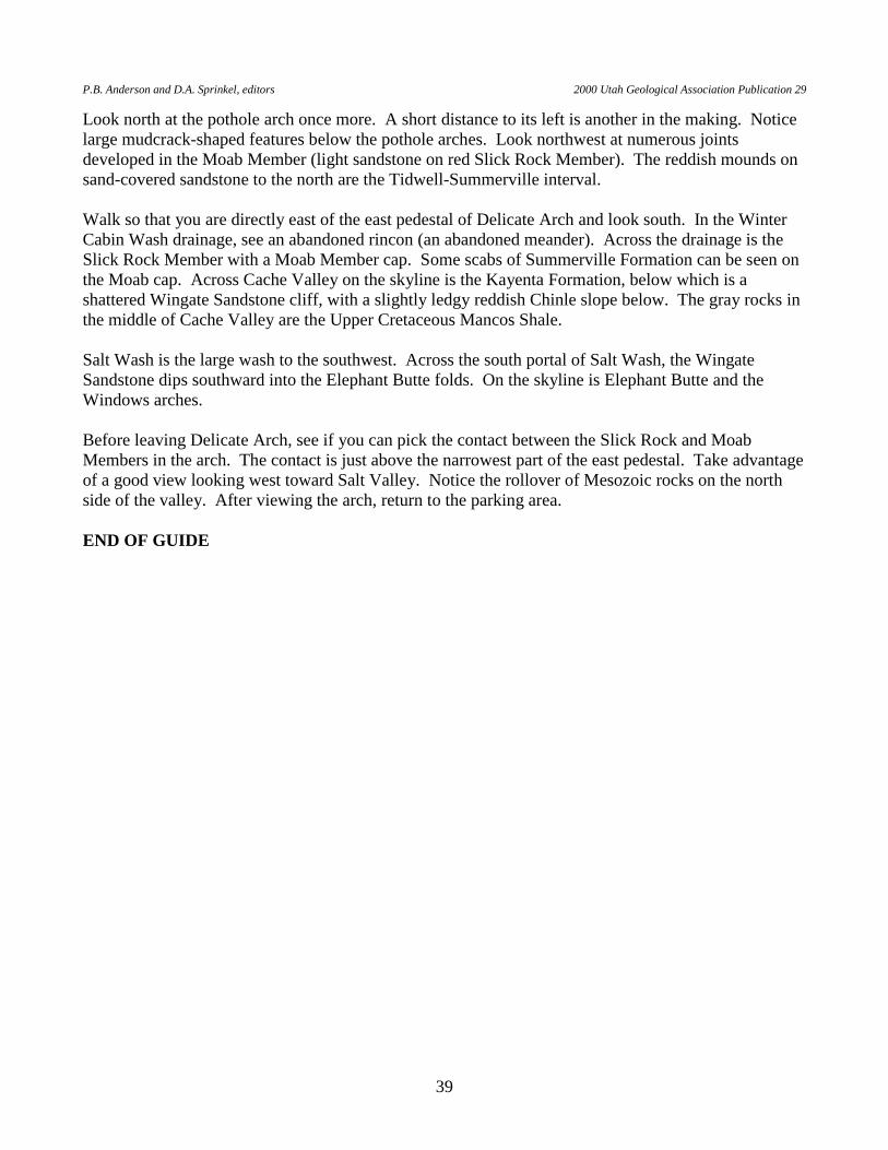
GEOLOGIC ROAD AND TRAIL GUIDES TO ARCHES...
44
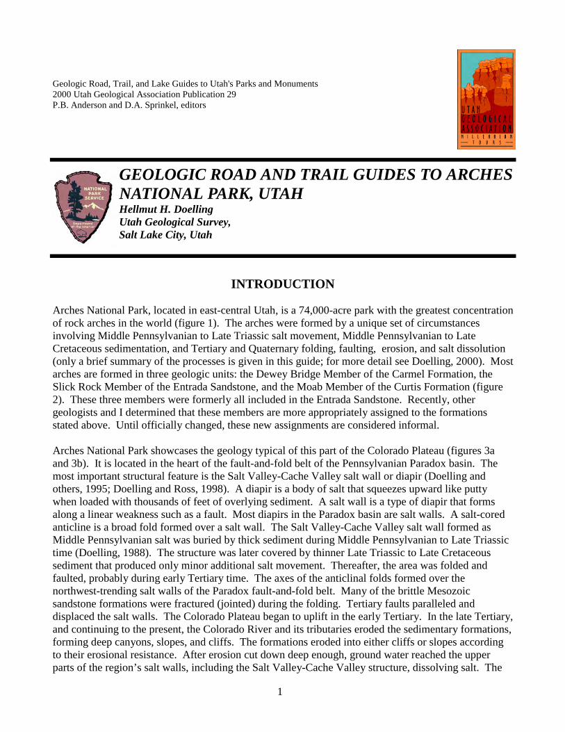
Geologic Road, Trail, and Lake Guides to Utah's Parks and Monuments 2000 Utah Geological Association Publication 29 P.B. Anderson and D.A. Sprinkel, editors INTRODUCTION Arches National Park, located in east-central Utah, is a 74,000-acre park with the greatest concentration of rock arches in the world (figure 1). The arches were formed by a unique set of circumstances involving Middle Pennsylvanian to Late Triassic salt movement, Middle Pennsylvanian to Late Cretaceous sedimentation, and Tertiary and Quaternary folding, faulting, erosion, and salt dissolution (only a brief summary of the processes is given in this guide; for more detail see Doelling, 2000). Most arches are formed in three geologic units: the Dewey Bridge Member of the Carmel Formation, the Slick Rock Member of the Entrada Sandstone, and the Moab Member of the Curtis Formation (figure 2). These three members were formerly all included in the Entrada Sandstone. Recently, other geologists and I determined that these members are more appropriately assigned to the formations stated above. Until officially changed, these new assignments are considered informal. Arches National Park showcases the geology typical of this part of the Colorado Plateau (figures 3a and 3b). It is located in the heart of the fault-and-fold belt of the Pennsylvanian Paradox basin. The most important structural feature is the Salt Valley-Cache Valley salt wall or diapir (Doelling and others, 1995; Doelling and Ross, 1998). A diapir is a body of salt that squeezes upward like putty when loaded with thousands of feet of overlying sediment. A salt wall is a type of diapir that forms along a linear weakness such as a fault. Most diapirs in the Paradox basin are salt walls. A salt-cored anticline is a broad fold formed over a salt wall. The Salt Valley-Cache Valley salt wall formed as Middle Pennsylvanian salt was buried by thick sediment during Middle Pennsylvanian to Late Triassic time (Doelling, 1988). The structure was later covered by thinner Late Triassic to Late Cretaceous sediment that produced only minor additional salt movement. Thereafter, the area was folded and faulted, probably during early Tertiary time. The axes of the anticlinal folds formed over the northwest-trending salt walls of the Paradox fault-and-fold belt. Many of the brittle Mesozoic sandstone formations were fractured (jointed) during the folding. Tertiary faults paralleled and displaced the salt walls. The Colorado Plateau began to uplift in the early Tertiary. In the late Tertiary, and continuing to the present, the Colorado River and its tributaries eroded the sedimentary formations, forming deep canyons, slopes, and cliffs. The formations eroded into either cliffs or slopes according to their erosional resistance. After erosion cut down deep enough, ground water reached the upper parts of the region’s salt walls, including the Salt Valley-Cache Valley structure, dissolving salt. The GEOLOGIC ROAD AND TRAIL GUIDES TO ARCHES NATIONAL PARK, UTAH Hellmut H. Doelling Utah Geological Survey, Salt Lake City, Utah 1
Transcript of GEOLOGIC ROAD AND TRAIL GUIDES TO ARCHES...
Geologic Road, Trail, and Lake Guides to Utah's Parks and Monuments 2000 Utah Geological Association Publication 29 P.B. Anderson and D.A. Sprinkel, editors
INTRODUCTION
Arches National Park, located in east-central Utah, is a 74,000-acre park with the greatest concentration of rock arches in the world (figure 1). The arches were formed by a unique set of circumstances involving Middle Pennsylvanian to Late Triassic salt movement, Middle Pennsylvanian to Late Cretaceous sedimentation, and Tertiary and Quaternary folding, faulting, erosion, and salt dissolution (only a brief summary of the processes is given in this guide; for more detail see Doelling, 2000). Most arches are formed in three geologic units: the Dewey Bridge Member of the Carmel Formation, the Slick Rock Member of the Entrada Sandstone, and the Moab Member of the Curtis Formation (figure 2). These three members were formerly all included in the Entrada Sandstone. Recently, other geologists and I determined that these members are more appropriately assigned to the formations stated above. Until officially changed, these new assignments are considered informal. Arches National Park showcases the geology typical of this part of the Colorado Plateau (figures 3a and 3b). It is located in the heart of the fault-and-fold belt of the Pennsylvanian Paradox basin. The most important structural feature is the Salt Valley-Cache Valley salt wall or diapir (Doelling and others, 1995; Doelling and Ross, 1998). A diapir is a body of salt that squeezes upward like putty when loaded with thousands of feet of overlying sediment. A salt wall is a type of diapir that forms along a linear weakness such as a fault. Most diapirs in the Paradox basin are salt walls. A salt-cored anticline is a broad fold formed over a salt wall. The Salt Valley-Cache Valley salt wall formed as Middle Pennsylvanian salt was buried by thick sediment during Middle Pennsylvanian to Late Triassic time (Doelling, 1988). The structure was later covered by thinner Late Triassic to Late Cretaceous sediment that produced only minor additional salt movement. Thereafter, the area was folded and faulted, probably during early Tertiary time. The axes of the anticlinal folds formed over the northwest-trending salt walls of the Paradox fault-and-fold belt. Many of the brittle Mesozoic sandstone formations were fractured (jointed) during the folding. Tertiary faults paralleled and displaced the salt walls. The Colorado Plateau began to uplift in the early Tertiary. In the late Tertiary, and continuing to the present, the Colorado River and its tributaries eroded the sedimentary formations, forming deep canyons, slopes, and cliffs. The formations eroded into either cliffs or slopes according to their erosional resistance. After erosion cut down deep enough, ground water reached the upper parts of the region’s salt walls, including the Salt Valley-Cache Valley structure, dissolving salt. The
GEOLOGIC ROAD AND TRAIL GUIDES TO ARCHES NATIONAL PARK, UTAH Hellmut H. Doelling Utah Geological Survey, Salt Lake City, Utah
1
H.H. Doelling Geologic Road and Trail Guides to Arches National Park, Utah
2
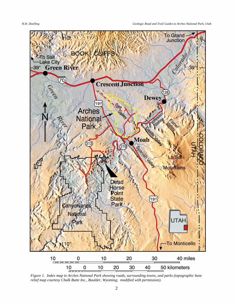
Figure 1. Index map to Arches National Park showing roads, surrounding towns, and parks (topographic base relief map courtesy Chalk Butte Inc., Boulder, Wyoming; modified with permission).
P.B. Anderson and D.A. Sprinkel, editors 2000 Utah Geological Association Publication 29
3
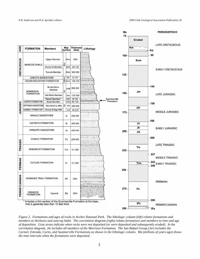
Figure 2. Formations and ages of rocks in Arches National Park. The lithologic column (left) relates formations and members to thickness and outcrop habit. The correlation diagram (right) relates formations and members to time and age of deposition. Gray areas indicate when rocks were not deposited (or were deposited and subsequently eroded). In the correlation diagram, Jm includes all members of the Morrison Formation. The San Rafael Group (Jsr) includes the Carmel, Entrada, Curtis, and Summerville Formations as shown in the lithologic column. Ma (millions of years ago) shows the time intervals when the formations were deposited.
H.H. Doelling Geologic Road and Trail Guides to Arches National Park, Utah
4
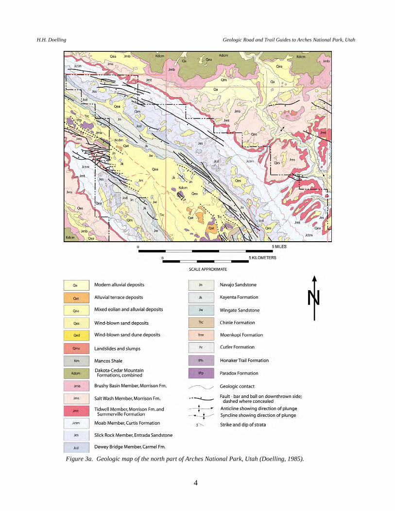
Figure 3a. Geologic map of the north part of Arches National Park, Utah (Doelling, 1985).
P.B. Anderson and D.A. Sprinkel, editors 2000 Utah Geological Association Publication 29
5
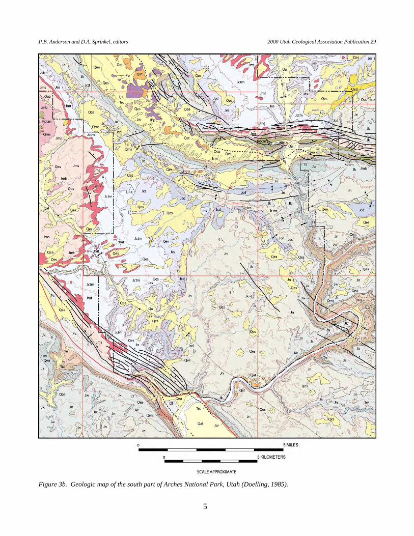
Figure 3b. Geologic map of the south part of Arches National Park, Utah (Doelling, 1985).
H.H. Doelling Geologic Road and Trail Guides to Arches National Park, Utah
6
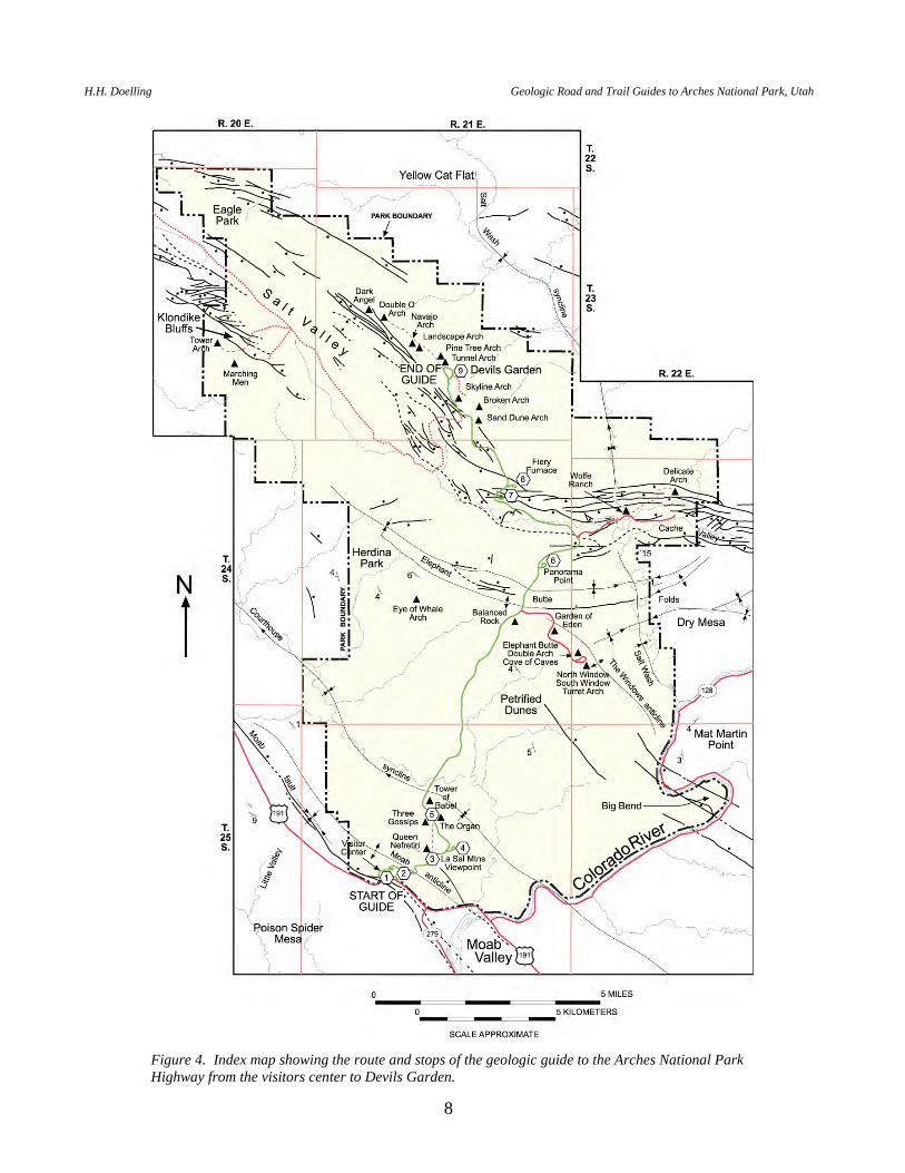
ensuing collapse of overlying formations created graben-valleys that overlie the salt walls today. As they were undermined, hard, brittle sandstone beds “rolled over” or sagged into the salt-dissolution valleys or grabens, opening long parallel joints. Erosion along the open joints formed fins and walls. Weathering then attacked weak horizontal zones, such as formation boundaries, bedding planes, and soft partings, forming alcoves and arches in and through the fins. Hence, most arches are located along the rims of the salt valleys where the favorable formations begin to “roll over” and collapse into the grabens. Each road and trail along the rims of the Salt Valley-Cache Valley graben provides access to several arches, especially in the Devils Garden area (figure 4). Delicate Arch, developed at the contact between the Entrada and Curtis Formations, is the most famous, and is located on the north rim of the Cache Valley portion of the salt wall. The Fiery Furnace is a well-developed area of stone fins that form a colorful maze of narrow passageways. These geologic road and trail guides to Arches National Park follow well-established roads and trails in and out of Arches National Park. However, please check with park rangers for any restrictions and road conditions before following these guides. GEOLOGIC ROAD GUIDE FROM THE VISITOR CENTER TO THE DEVILS GARDEN LOOP (19.6 miles) .................................................................................................................. 7 GEOLOGIC ROAD GUIDE FROM KLONDIKE BLUFFS JUNCTION TO U.S. HIGHWAY 191 (23.6 miles) .......................................................................................................... 17 GEOLOGIC ROAD GUIDE ALONG OLD U.S. HIGHWAY 191 TO SEVENMILE CANYON (7.7 miles) ............................................................................................................................. 23 GEOLOGIC ROAD GUIDE ALONG STATE HIGHWAY 128 FROM U.S. HIGHWAY 191 TO THE CASTLE VALLEY ROAD (15.7 miles) ................................................................................. 29 GEOLOGIC ROAD GUIDE ALONG THE DELICATE ARCH HIGHWAY (2.3 miles) ................... 35 GEOLOGIC TRAIL GUIDE TO DELICATE ARCH (1.5 miles) ......................................................... 37 GEOLOGIC ROAD GUIDE ALONG THE WINDOWS HIGHWAY (2.7 miles) ............................... 40 Total miles .................................................................................................................................. 73.0 miles
P.B. Anderson and D.A. Sprinkel, editors 2000 Utah Geological Association Publication 29
7
GEOLOGIC ROAD GUIDE FROM THE VISITOR CENTER TO THE DEVILS GARDEN LOOP
This road guide is run along a national park highway and is easily traversed in a passenger car. The full road guide generally takes an hour in one direction. If the traveler wishes to take pictures and examine outcrops, this trip will take longer. The distance to the Devils Garden Loop, without side trips, is about 20 miles. This guide commences at the junction of U.S. Highway 191 and the Arches National Park Highway near the visitor center and ends at Devils Garden Loop (figure 4). MILEAGE DESCRIPTION INTERVAL/CUMULATIVE 0.0 0.0 Junction U.S. Highway 191 and the road to the visitor center, about 5 miles
northwest of the town of Moab. 0.2 0.2 Entry gate. Entrance fees are required to enter Arches National Park. After
paying fee, turn right into the visitor center parking lot. The visitor center contains a bookstore that has maps, books, and other publications on Arches National Park, geologic displays and exhibits, and a small auditorium for a slide show.
STOP 1 - ARCHES NATIONAL PARK PARKING LOT. First, view the
formations exposed on the northeast side of U.S. Highway 191 (the visitor center side). The light-colored, massive, cross-bedded sandstone at ground level and rising to the southeast is the Navajo Sandstone. It is overlain by dark-red-brown, somewhat contorted and irregular beds of the Dewey Bridge Member of the Carmel Formation. Above the Dewey Bridge are cliffs of light-brown or orange-brown Slick Rock Member of the Entrada Sandstone. Above the cliffs you can see a thin layer of the Moab Member of the Curtis Formation. The Moab Member is a lighter-hued sandstone. Look northeast above the rise in the road to see a seep developed along a surface at the base of the Moab Member. Look to the north where road fill is visible in the corner above the visitor center. There, a pile of partially bleached rocks marks an ancient collapse feature that parallels a joint in the Navajo Sandstone.
Take a short hike west along the drainage between U.S. 191 and the Park
Highway. Upstream about 800 feet is a slickensided surface where the Moab fault cuts limestone beds of the Pennsylvanian Honaker Trail Formation that contain some poorly preserved fossils. In this area, the Moab fault is split into two branches; the branch cutting the Honaker Trail Formation is known as the west branch fault. The main branch of the fault is exposed a few hundred feet to the east in the same wash, but it is difficult to find slickensides at that location. The west branch fault places the Pennsylvanian Honaker Trail Formation against a slice of chocolate-brown Lower Triassic Moenkopi Formation. The main
H.H. Doelling Geologic Road and Trail Guides to Arches National Park, Utah
8
Figure 4. Index map showing the route and stops of the geologic guide to the Arches National Park Highway from the visitors center to Devils Garden.
P.B. Anderson and D.A. Sprinkel, editors 2000 Utah Geological Association Publication 29
9
branch places the slice of Moenkopi Formation against the Entrada Sandstone. The displacement across both branches of the fault is about 2,400 feet based on formation thicknesses. While at the slickensided surface, look south across U.S. 191 to a high road cut in which several small branches of the Moab fault are displayed. Leave visitor center parking lot.
0.1 0.3 Turn right and proceed up the national park highway. The road quickly cuts
through the Slick Rock Member of the Entrada Sandstone, into the Dewey Bridge Member of the Carmel Formation, and then makes switchbacks on the Navajo Sandstone (descending stratigraphically).
0.2 0.5 Collapse feature mentioned in the parking lot discussion to right. 0.4 0.9 Three Penguins (the prominence of the Slick Rock Member on the Dewey
Bridge Member) ahead as the road reverses in the switchback. Small faults, noticeable by the absence of the cut out Dewey Bridge Member, parallel the highway after coming out of the switchback.
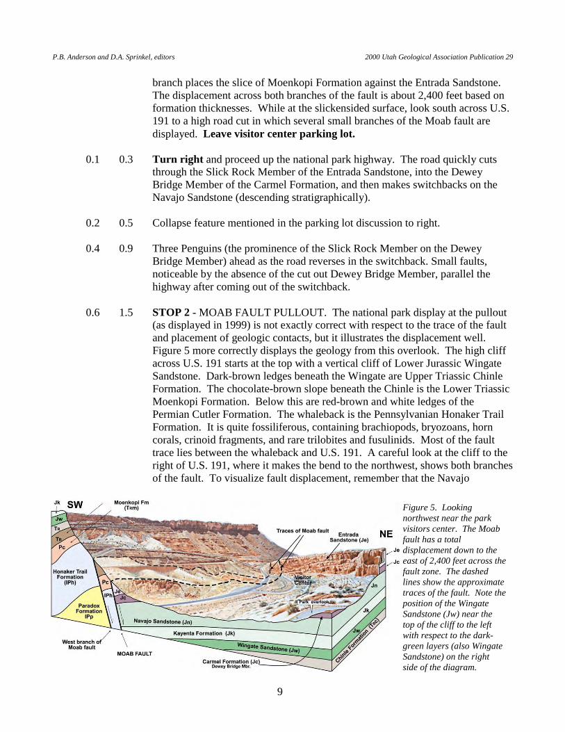
0.6 1.5 STOP 2 - MOAB FAULT PULLOUT. The national park display at the pullout
(as displayed in 1999) is not exactly correct with respect to the trace of the fault and placement of geologic contacts, but it illustrates the displacement well. Figure 5 more correctly displays the geology from this overlook. The high cliff across U.S. 191 starts at the top with a vertical cliff of Lower Jurassic Wingate Sandstone. Dark-brown ledges beneath the Wingate are Upper Triassic Chinle Formation. The chocolate-brown slope beneath the Chinle is the Lower Triassic Moenkopi Formation. Below this are red-brown and white ledges of the Permian Cutler Formation. The whaleback is the Pennsylvanian Honaker Trail Formation. It is quite fossiliferous, containing brachiopods, bryozoans, horn corals, crinoid fragments, and rare trilobites and fusulinids. Most of the fault trace lies between the whaleback and U.S. 191. A careful look at the cliff to the right of U.S. 191, where it makes the bend to the northwest, shows both branches of the fault. To visualize fault displacement, remember that the Navajo
Figure 5. Looking northwest near the park visitors center. The Moab fault has a total displacement down to the east of 2,400 feet across the fault zone. The dashed lines show the approximate traces of the fault. Note the position of the Wingate Sandstone (Jw) near the top of the cliff to the left with respect to the dark-green layers (also Wingate Sandstone) on the right side of the diagram.
H.H. Doelling Geologic Road and Trail Guides to Arches National Park, Utah
10
Sandstone, at the level of the visitor center on the downthrown side of the fault, would be 400 feet above the Wingate Sandstone cliff on the upthrown block of the Moab fault (had it not been eroded off). Return to highway.
0.6 2.1 Highway is on Navajo Sandstone, snakes around an Entrada Sandstone cliff,
and eventually crosses the axis of the Moab anticline. 0.4 2.5 STOP 3 - PARK AVENUE. Take a walk to the viewpoint at the rise in the trail.
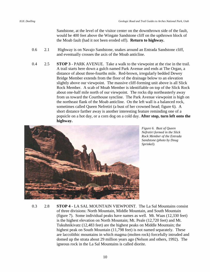
A trail starts here down a gulch named Park Avenue and ends at The Organ, a distance of about three-fourths mile. Red-brown, irregularly bedded Dewey Bridge Member extends from the floor of the drainage below to an elevation slightly above our viewpoint. The massive cliff-forming unit above is all Slick Rock Member. A scab of Moab Member is identifiable on top of the Slick Rock about one-half mile north of our viewpoint. The rocks dip northeasterly away from us toward the Courthouse syncline. The Park Avenue viewpoint is high on the northeast flank of the Moab anticline. On the left wall is a balanced rock, sometimes called Queen Nefretiri (a bust of her crowned head; figure 6). A short distance farther away is another interesting feature reminding one of a popsicle on a hot day, or a corn dog on a cold day. After stop, turn left onto the highway.
0.3 2.8 STOP 4 - LA SAL MOUNTAIN VIEWPOINT. The La Sal Mountains consist of three divisions: North Mountain, Middle Mountain, and South Mountain (figure 7). Some individual peaks have names as well. Mt. Waas (12,330 feet) is the highest elevation on North Mountain; Mt. Peale (12,720 feet) and Mt. Tukuhnikivatz (12,483 feet) are the highest peaks on Middle Mountain; the highest peak on South Mountain (11,798 feet) is not named separately. These are laccolithic mountains in which magma (molten rock) forcefully intruded and domed up the strata about 29 million years ago (Nelson and others, 1992). The igneous rock in the La Sal Mountains is called diorite.
Figure 6. Bust of Queen Nefretiri formed in the Slick Rock Member of the Entrada Sandstone (photo by Doug Sprinkel).

P.B. Anderson and D.A. Sprinkel, editors 2000 Utah Geological Association Publication 29
11
From the viewpoint we look easterly into the trough of the Courthouse syncline. Temple Rock, down dip from our viewpoint, resembles the Church of Jesus Christ of Latter-Day Saints (Mormon) Temple in Salt Lake City. Farther east, the Navajo Sandstone surface rises out of the Courthouse synclinal trough. South of the Colorado River canyon, the Navajo rises onto the flank of the Castle Valley salt-cored anticline. North of the Colorado River canyon, it rises onto the flank of The Windows anticline. Elephant Butte straddles the axis of The Windows anticline and contains the famous North and South Windows Arches. You should be able to look through one of these windows from this viewpoint. Walk out on the rocks to the national park exhibits. To the north from this spot are nice views of the Courthouse Towers, including The Three Gossips, Sheep Rock, Tower of Babel, and The Organ. Look behind you to see the arcuate upper surface of the Moab anticline defined by the Navajo Sandstone. After the stop, turn right onto the main highway and continue to the north.
0.3 3.1 The road cut is in the Dewey Bridge Member of the Carmel Formation. The
road drops down the dip slope on the northeast flank of the Moab anticline. 0.8 3.9 Small turnout on highway on the right side. Look left for a fine view of The
Three Gossips. Note the tafoni (jokingly referred to as “stonepecker holes”) in the Slick Rock Member.
0.2 4.1 STOP 5 - COURTHOUSE TOWERS VIEWPOINT. Look across the highway
to the crevice arch known as Baby Arch. The rock in this fin of Slick Rock Member of the Entrada Sandstone is undoubtedly under stress. These stresses will eventually cause rock above the crevice to fracture and break out, building a larger arch. Large arches, now fallen, may have once existed between this fin and its extension down dip. Look beyond the Three Gossips. The Moab Member of the Curtis Formation is the cap rock on top of the cliffs. The Moab Member has no tafoni (stonepecker holes). After stop, continue down the highway into the axis of the Courthouse syncline.
Figure 7. The La Sal Mountains from a viewpoint in Arches National Park. These mountains are divided into three parts: North Mountain (left), Middle Mountain, and South Mountain (right). The La Sals are cored by igneous rocks that form dome- or mushroom-shaped intrusions that geologists call laccoliths. The igneous rocks in the north and south parts of these mountains intruded into salt.
H.H. Doelling Geologic Road and Trail Guides to Arches National Park, Utah
12
0.9 5.0 Cross Courthouse Wash and axis of Courthouse syncline. 0.7 5.7 Pass a knob of Dewey Bridge Member on the left side. The road veers left and
extends northward with the Great Wall to the left. The Great Wall consists of Slick Rock Member on Dewey Bridge Member.
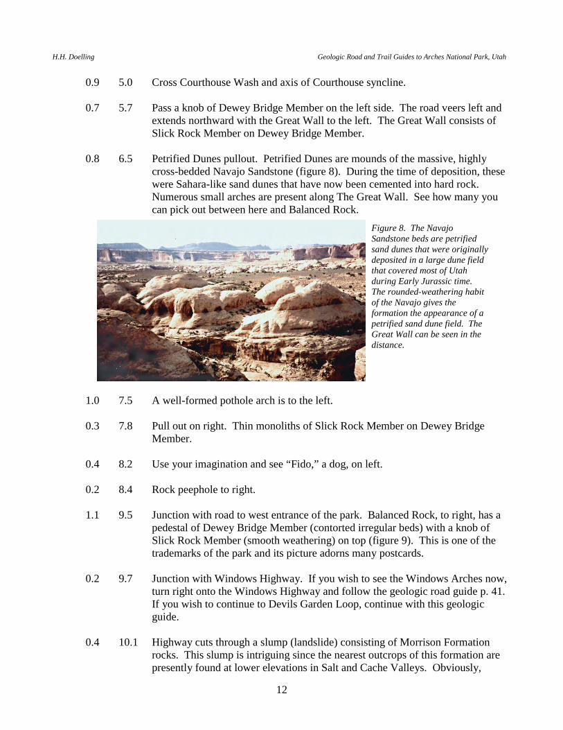
0.8 6.5 Petrified Dunes pullout. Petrified Dunes are mounds of the massive, highly
cross-bedded Navajo Sandstone (figure 8). During the time of deposition, these were Sahara-like sand dunes that have now been cemented into hard rock. Numerous small arches are present along The Great Wall. See how many you can pick out between here and Balanced Rock.
1.0 7.5 A well-formed pothole arch is to the left. 0.3 7.8 Pull out on right. Thin monoliths of Slick Rock Member on Dewey Bridge
Member. 0.4 8.2 Use your imagination and see “Fido,” a dog, on left. 0.2 8.4 Rock peephole to right. 1.1 9.5 Junction with road to west entrance of the park. Balanced Rock, to right, has a
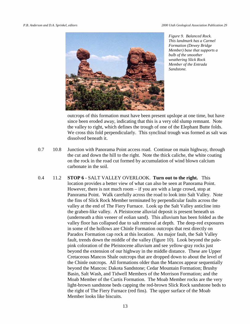
pedestal of Dewey Bridge Member (contorted irregular beds) with a knob of Slick Rock Member (smooth weathering) on top (figure 9). This is one of the trademarks of the park and its picture adorns many postcards.
0.2 9.7 Junction with Windows Highway. If you wish to see the Windows Arches now,
turn right onto the Windows Highway and follow the geologic road guide p. 41. If you wish to continue to Devils Garden Loop, continue with this geologic guide.
0.4 10.1 Highway cuts through a slump (landslide) consisting of Morrison Formation
rocks. This slump is intriguing since the nearest outcrops of this formation are presently found at lower elevations in Salt and Cache Valleys. Obviously,
Figure 8. The Navajo Sandstone beds are petrified sand dunes that were originally deposited in a large dune field that covered most of Utah during Early Jurassic time. The rounded-weathering habit of the Navajo gives the formation the appearance of a petrified sand dune field. The Great Wall can be seen in the distance.
P.B. Anderson and D.A. Sprinkel, editors 2000 Utah Geological Association Publication 29
13
outcrops of this formation must have been present upslope at one time, but have since been eroded away, indicating that this is a very old slump remnant. Note the valley to right, which defines the trough of one of the Elephant Butte folds. We cross this fold perpendicularly. This synclinal trough was formed as salt was dissolved beneath it.
0.7 10.8 Junction with Panorama Point access road. Continue on main highway, through
the cut and down the hill to the right. Note the thick caliche, the white coating on the rock in the road cut formed by accumulation of wind blown calcium carbonate in the soil.
0.4 11.2 STOP 6 - SALT VALLEY OVERLOOK. Turn out to the right. This
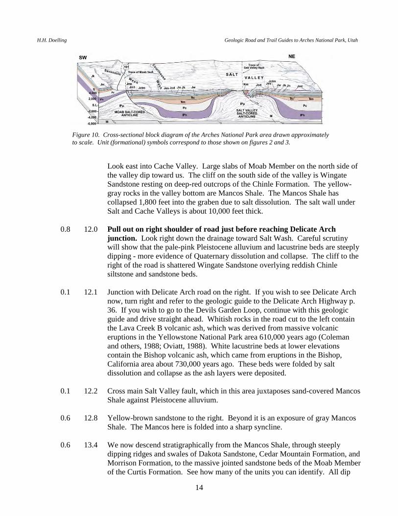
location provides a better view of what can also be seen at Panorama Point. However, there is not much room – if you are with a large crowd, stop at Panorama Point. Walk carefully across the road to look into Salt Valley. Note the fins of Slick Rock Member terminated by perpendicular faults across the valley at the end of The Fiery Furnace. Look up the Salt Valley anticline into the graben-like valley. A Pleistocene alluvial deposit is present beneath us (underneath a thin veneer of eolian sand). This alluvium has been folded as the valley floor has collapsed due to salt removal at depth. The deep-red exposures in some of the hollows are Chinle Formation outcrops that rest directly on Paradox Formation cap rock at this location. An major fault, the Salt Valley fault, trends down the middle of the valley (figure 10). Look beyond the pale-pink coloration of the Pleistocene alluvium and see yellow-gray rocks just beyond the extension of our highway in the middle distance. These are Upper Cretaceous Mancos Shale outcrops that are dropped down to about the level of the Chinle outcrops. All formations older than the Mancos appear sequentially beyond the Mancos: Dakota Sandstone; Cedar Mountain Formation; Brushy Basin, Salt Wash, and Tidwell Members of the Morrison Formation; and the Moab Member of the Curtis Formation. The Moab Member rocks are the very light-brown sandstone beds capping the red-brown Slick Rock sandstone beds to the right of The Fiery Furnace (red fins). The upper surface of the Moab Member looks like biscuits.
Figure 9. Balanced Rock. This landmark has a Carmel Formation (Dewey Bridge Member) base that supports a bulb of the smoother weathering Slick Rock Member of the Entrada Sandstone.
H.H. Doelling Geologic Road and Trail Guides to Arches National Park, Utah
14
Look east into Cache Valley. Large slabs of Moab Member on the north side of
the valley dip toward us. The cliff on the south side of the valley is Wingate Sandstone resting on deep-red outcrops of the Chinle Formation. The yellow-gray rocks in the valley bottom are Mancos Shale. The Mancos Shale has collapsed 1,800 feet into the graben due to salt dissolution. The salt wall under Salt and Cache Valleys is about 10,000 feet thick.
0.8 12.0 Pull out on right shoulder of road just before reaching Delicate Arch
junction. Look right down the drainage toward Salt Wash. Careful scrutiny will show that the pale-pink Pleistocene alluvium and lacustrine beds are steeply dipping - more evidence of Quaternary dissolution and collapse. The cliff to the right of the road is shattered Wingate Sandstone overlying reddish Chinle siltstone and sandstone beds.
0.1 12.1 Junction with Delicate Arch road on the right. If you wish to see Delicate Arch
now, turn right and refer to the geologic guide to the Delicate Arch Highway p. 36. If you wish to go to the Devils Garden Loop, continue with this geologic guide and drive straight ahead. Whitish rocks in the road cut to the left contain the Lava Creek B volcanic ash, which was derived from massive volcanic eruptions in the Yellowstone National Park area 610,000 years ago (Coleman and others, 1988; Oviatt, 1988). White lacustrine beds at lower elevations contain the Bishop volcanic ash, which came from eruptions in the Bishop, California area about 730,000 years ago. These beds were folded by salt dissolution and collapse as the ash layers were deposited.
0.1 12.2 Cross main Salt Valley fault, which in this area juxtaposes sand-covered Mancos
Shale against Pleistocene alluvium. 0.6 12.8 Yellow-brown sandstone to the right. Beyond it is an exposure of gray Mancos
Shale. The Mancos here is folded into a sharp syncline. 0.6 13.4 We now descend stratigraphically from the Mancos Shale, through steeply
dipping ridges and swales of Dakota Sandstone, Cedar Mountain Formation, and Morrison Formation, to the massive jointed sandstone beds of the Moab Member of the Curtis Formation. See how many of the units you can identify. All dip
Figure 10. Cross-sectional block diagram of the Arches National Park area drawn approximately to scale. Unit (formational) symbols correspond to those shown on figures 2 and 3.
P.B. Anderson and D.A. Sprinkel, editors 2000 Utah Geological Association Publication 29
15
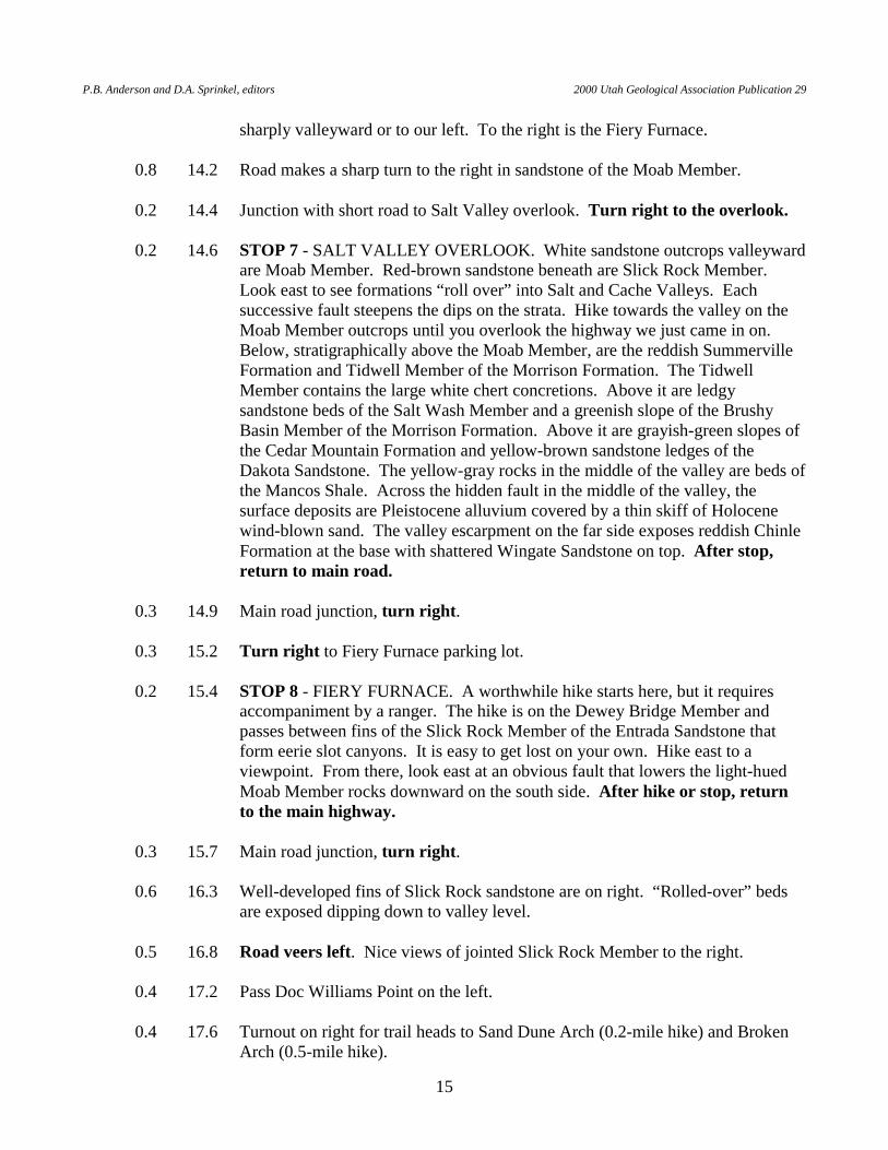
sharply valleyward or to our left. To the right is the Fiery Furnace. 0.8 14.2 Road makes a sharp turn to the right in sandstone of the Moab Member. 0.2 14.4 Junction with short road to Salt Valley overlook. Turn right to the overlook. 0.2 14.6 STOP 7 - SALT VALLEY OVERLOOK. White sandstone outcrops valleyward
are Moab Member. Red-brown sandstone beneath are Slick Rock Member. Look east to see formations “roll over” into Salt and Cache Valleys. Each successive fault steepens the dips on the strata. Hike towards the valley on the Moab Member outcrops until you overlook the highway we just came in on. Below, stratigraphically above the Moab Member, are the reddish Summerville Formation and Tidwell Member of the Morrison Formation. The Tidwell Member contains the large white chert concretions. Above it are ledgy sandstone beds of the Salt Wash Member and a greenish slope of the Brushy Basin Member of the Morrison Formation. Above it are grayish-green slopes of the Cedar Mountain Formation and yellow-brown sandstone ledges of the Dakota Sandstone. The yellow-gray rocks in the middle of the valley are beds of the Mancos Shale. Across the hidden fault in the middle of the valley, the surface deposits are Pleistocene alluvium covered by a thin skiff of Holocene wind-blown sand. The valley escarpment on the far side exposes reddish Chinle Formation at the base with shattered Wingate Sandstone on top. After stop, return to main road.
0.3 14.9 Main road junction, turn right. 0.3 15.2 Turn right to Fiery Furnace parking lot. 0.2 15.4 STOP 8 - FIERY FURNACE. A worthwhile hike starts here, but it requires
accompaniment by a ranger. The hike is on the Dewey Bridge Member and passes between fins of the Slick Rock Member of the Entrada Sandstone that form eerie slot canyons. It is easy to get lost on your own. Hike east to a viewpoint. From there, look east at an obvious fault that lowers the light-hued Moab Member rocks downward on the south side. After hike or stop, return to the main highway.
0.3 15.7 Main road junction, turn right. 0.6 16.3 Well-developed fins of Slick Rock sandstone are on right. “Rolled-over” beds
are exposed dipping down to valley level. 0.5 16.8 Road veers left. Nice views of jointed Slick Rock Member to the right. 0.4 17.2 Pass Doc Williams Point on the left. 0.4 17.6 Turnout on right for trail heads to Sand Dune Arch (0.2-mile hike) and Broken
Arch (0.5-mile hike).
H.H. Doelling Geologic Road and Trail Guides to Arches National Park, Utah
16
0.4 18.0 Junction with road to Klondike Bluffs on left. If you wish to go to Klondike
Bluffs, turn left and refer to the Klondike Bluffs geologic road guide. If you wish to continue to Devils Garden Loop, continue with this guide and drive straight ahead. I suggest that you complete the Devils Garden Loop if you have not done so before, then return to this location.
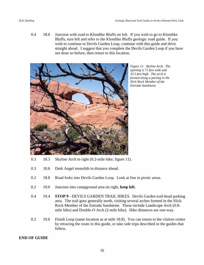
0.3 18.3 Skyline Arch to right (0.2-mile hike; figure 11). 0.3 18.6 Dark Angel monolith in distance ahead. 0.2 18.8 Road forks into Devils Garden Loop. Look at fins in picnic areas. 0.2 19.0 Junction into campground area on right, keep left. 0.4 19.4 STOP 9 - DEVILS GARDEN TRAIL HIKES. Devils Garden trail-head parking
area. The trail goes generally north, visiting several arches formed in the Slick Rock Member of the Entrada Sandstone. These include Landscape Arch (0.8-mile hike) and Double-O Arch (2-mile hike). Hike distances are one-way.
0.2 19.6 Finish Loop (same location as at mile 18.8). You can return to the visitors center
by retracing the route in this guide, or take side trips described in the guides that follow.
END OF GUIDE
Figure 11. Skyline Arch. The opening is 71 feet wide and 33.5 feet high. The arch is formed along a parting in the Slick Rock Member of the Entrada Sandstone.
P.B. Anderson and D.A. Sprinkel, editors 2000 Utah Geological Association Publication 29
17
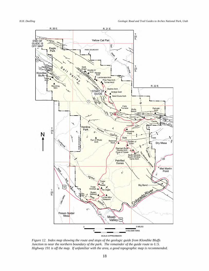
GEOLOGIC ROAD GUIDE FROM KLONDIKE BLUFFS JUNCTION TO U.S. HIGHWAY 191.
This route is a dirt road. It is possible for a passenger car to negotiate this road in dry weather. However, a high-clearance vehicle is recommended. It is not a good idea to drive campers and trailers over this road. To follow the full road guide generally takes two hours in one direction. If the traveler wishes to take pictures and examine outcrops, this trip will take longer. The distance from the Devils Garden area, without side trips, is about 24 miles. This guide commences at the junction with the Klondike Bluffs road, about a mile south of the Devils Garden Loop on the Arches National Park Highway, and ends at U.S. Highway 191 about 25 miles north of Moab (figure 12). MILEAGE DESCRIPTION INTERVAL/CUMULATIVE 0.0 0.0 Klondike Bluffs Junction. Proceed westerly down a grade toward Salt Valley. 0.9 0.9 Pull off to the right to look at a grayish mound to the north. The mound is
Paradox Formation cap rock. The reddish Chinle laps onto the mound or small dome from all sides. The white rocks nearly at valley level to the right of the dome are outcrops of Moab Member of the Curtis Formation. The Dark Angel spire can be seen directly above and north of these white rocks.
0.4 1.3 Well exposed strata “roll over” valleyward to the left. 0.8 2.1 Steeply dipping Middle and Upper Jurassic rocks are visible across the drainage
to the left. 0.3 2.4 Road turns right into the drainage at the valley bottom. The road is in thick
alluvium for 0.5 miles. 0.5 2.9 At a turn in the wash, note a mostly consolidated Pleistocene gravel cap on
contorted gypsiferous gray shale that is Paradox Formation cap rock. Less consolidated Pleistocene alluvium is on top of the gravel cap. The gravel cap indicates that the wash bed was once at a higher relative level before incising to its present position.
0.1 3.0 STOP 1 - PARADOX FORMATION CAP ROCK. The bluffs of gypsiferous
rock on the right are Paradox Formation cap rock. They consist of thin-bedded gray shale, limestone, gypsum, and sandstone. Cap rock is the less soluble portion of the Paradox Formation that remains as a residual cap after the soluble minerals such as halite are dissolved out. Note the contorted beds. About 500 feet of this cap rock is estimated to overlie a salt wall about 10,000 feet thick composed mostly of salt with minor interlayered sediment similar to that seen here. The upper surface of the cap rock is irregular and undulating in the valley
H.H. Doelling Geologic Road and Trail Guides to Arches National Park, Utah
18
Figure 12. Index map showing the route and stops of the geologic guide from Klondike Bluffs Junction to near the northern boundary of the park. The remainder of the guide route to U.S. Highway 191 is off the map. If unfamiliar with the area, a good topographic map is recommended.
P.B. Anderson and D.A. Sprinkel, editors 2000 Utah Geological Association Publication 29
19
bottom. Mounds (expressed as low hills) of cap rock are quite resistant and rise above low areas, which are partly filled with alluvium.
0.6 3.6 Road turns right and crosses from the wash onto another mound of gypsiferous
cap rock. Gypsum in the cap rock gives the road a white or yellowish-white color. Gypsum surfaces are highly favored by cryptobiotic (hidden life) soil crust. Look left and right to see it. The cryptobiotic soil is zealously protected in this park.
0.9 4.5 The road drops off a large mound of Paradox Formation cap rock into the
alluvium-filled valley. The left rim of the valley exposes (ascending) shattered Chinle Formation, Wingate Sandstone, and Kayenta Formation. The Slick Rock Member of the Entrada Sandstone caps the rim rocks to the right. Most of the shattered rocks beneath it are “rolled-over” Wingate, Kayenta, and Navajo Formations.
2.7 7.2 Junction with the first road that leads left to Klondike Bluffs. This is a four-
wheel-drive, high-clearance vehicle road. It provides access to Tower Arch and connects with a road that parallels the Elephant Butte folds. This road is quite rough, but provides access to Herdina Park and Eye-of-the-Whale Arch. Our road guide continues on the Salt Valley Road.
0.1 7.3 Junction with the second road that leads left to Klondike Bluffs. Turn left. 1.0 8.3 STOP 2 - KLONDIKE BLUFFS HIKE. The white sandstone rocks to the right
are the Moab Member of the Curtis Formation faulted against the Dewey Bridge Member of the Carmel Formation. A 1.7-mile one-way hike to Tower Arch commences here. The trail rises on top of the Navajo Sandstone and follows the contact between the Navajo Sandstone and the Dewey Bridge Member. After hike, return to the Salt Valley Road.
1.0 9.3 Junction (same location as mile 7.3). Turn left (north). 1.2 10.5 To the left is the Moab Member of the Curtis Formation (white) on Slick Rock
Member of the Entrada Sandstone (red-brown). These formations flounder on cap rock of the Paradox Formation, which is not seen here. To the right the rim rocks are mainly Kayenta Formation with massive tan Navajo Sandstone on top. Some shattered Wingate also makes its appearance, as if forming an anticline below the Kayenta.
0.7 11.2 Cattle guard at Arches National Park boundary. Exit the park. 0.6 11.8 Bluffs to right commence in shattered Wingate Sandstone.
H.H. Doelling Geologic Road and Trail Guides to Arches National Park, Utah
20
0.5 12.3 Hills to left with ledges are thought to be anomalous sections of the Pennsylvanian Honaker Trail Formation. Some ledges are fossiliferous with poorly preserved and abraded specimens. The specimens appear to be reworked from an older formation; they may be Mississippian fossils eroded in Pennsylvanian time from the Uncompahgre uplift in the Utah-Colorado border area to the east, and washed into the Honaker Trail Formation. The low hills of Honaker Trail are mostly sandstone with a few ribs of limestone.
0.5 12.8 Junction. Take side road that veers left off the main road. Head southwest
across the valley. 0.4 13.2 Notice the angular chunks of limestone as you cross the extensions of the low
hills in the center of the valley. If you have time, hike into the hills and draw your own conclusions as to how the angular chunks formed.
0.3 13.5 As we approach outcrops of Salt Wash Member of Morrison Formation, the road
crosses a fault buried by alluvium. Stay on the road to the right (do not turn toward the small water catchment basin). The road rises onto the Salt Wash Member. From this point on, the road is commonly in poor condition. You may prefer to hike to the next stop. A four-wheel-drive, high-clearance vehicle is recommended if you choose to continue.
0.2 13.7 Junction, keep right. 0.1 13.8 STOP 3 - COPPER PROSPECTS IN SALT WASH MEMBER. Road ends at
old open-cast copper working in the Salt Wash Member. Azurite, malachite, and possibly copper pitch, coat ledges of limonitized Salt Wash sandstone. Several such workings are present on this flank of the Salt Valley anticline. Just to the northwest of this place is a larger operation that attempted to leach the copper from the sandstone in the early 1970s. Gard (1976) reported that activity was short-lived and had stopped by 1975. Only 21,000 tons of ore were mined because of problems in heap leaching. As much as 10 million tons of low-grade ore have been blocked out. Turn around.
0.1 13.9 Junction, keep right, proceed a few hundred feet. Road enters large area of
bare rock (Moab Member) with a flat surface after crossing a fault. STOP 4 - Get out of the vehicle to investigate the faults. Several normal fault traces are present in the Moab surface. To the southwest, along the margins of the Moab Member, are outcrops of the Summerville Formation and overlying Tidwell Member of the Morrison Formation. The Tidwell is calcareous and commonly contains large chert nodules. Dinosaur footprints are commonly found on the reworked sandstone at the top of the Moab Member or the base of the Summerville Formation. After looking about, return back across the valley to the Salt Valley road.
1.0 14.9 Salt Valley road junction (same location as mile 12.8), turn left.
P.B. Anderson and D.A. Sprinkel, editors 2000 Utah Geological Association Publication 29
21
0.4 15.3 The prominent sandstone ledge in rim rocks to the left is the Moab Member. The Moab Member is overlain by Summerville and Morrison Formations. To the right the shattered cliff is the Wingate Sandstone.
0.5 15.8 The low hills to the left are partly Pennsylvanian sandstone of the Honaker Trail
Formation and cap rock of the Pennsylvanian Paradox Formation. Locally, gravel caps are found on these hills.
0.7 16.5 The dark-red-brown rocks under the Wingate Sandstone to the right are Chinle
Formation. 0.2 16.7 Note the fault on the right along the rim rocks. The fault displaces the Wingate
Sandstone against the Lower Cretaceous Cedar Mountain Formation. All of the low hills for the next few miles are Cretaceous rocks rather than Pennsylvanian rocks as we have seen previously. Drillholes on the Wingate side of the fault show that the thickness of cap rock under the valley at this location is 450 to 1,000 feet.
0.6 17.3 On the left, the rim rock of Moab Member is broken up and collapses over the
reddish-orange Slick Rock Member. Dakota conglomerate is exposed in the hill to the right.
0.5 17.8 After the rise in the road, look right at the banded wall of Slick Rock Member
overlain by the Moab Member. The thin-bedded brown strata between the two units are normal Curtis Formation. The yellow slopes to the right are Mancos Shale. The hills to the left are Dakota Formation on Cedar Mountain Formation.
0.5 18.3 To the right the rim rocks are adjacent to the fault. Fine slickensides exposed
where the Moab Member dips under the valley surface are worth a walk. Morrison Formation strata overlie the Moab Member. A mound of Navajo Sandstone underlies the Dewey Bridge Member in the left rim rocks. The Dewey Bridge Member is overlain by banded Slick Rock Member and Moab Member. Notice the deep indentation between the Slick Rock and Moab.
0.3 18.6 Road is on Mancos Shale. Morrison Formation with variegated mudstones of
the Brushy Basin Member is exposed on the right rim rocks. 0.3 18.9 A high mound of Mancos Shale is present on the right or down-dropped side of a
fault. Behind the mound, on the upthrown block, is the Brushy Basin Member capped by the Cedar Mountain Formation. Rocks on both sides of the fault are plunging northwestward toward the valley level.
0.7 19.6 Road veers eastward; brown-stained Dakota Sandstone blocks are on the right. 0.1 19.7 Road junction, turn left. Road crosses Little Valley drainage on alluvial mud
derived from the Mancos Shale.
H.H. Doelling Geologic Road and Trail Guides to Arches National Park, Utah
22
0.4 20.1 The low hills to the right are the Ferron Sandstone Member of the Mancos Shale. To the left, the southwest side rim rocks are plunging northwestward. The flatirons at the base are mostly Mancos, Dakota, and Cedar Mountain strata, and dip valleyward from a fault against the rim rocks. We are on Mancos Shale outcrops.
0.8 20.9 Cattle guard with a gate. 0.5 21.4 Junction with old Moab-to-Thompson road. Right leads to Thompson and left to
U.S. Highway 191 and Moab. Turn left and cross bridge over Thompson Wash. Road is now on muddy alluvium of Thompson Wash. Enjoy the view left down Salt Valley.
2.0 23.4 Go through a gap in the Cedar Mountain Formation. 0.2 23.6 Cross railroad tracks, junction with U.S. Highway 191. Interstate Highway 70 at
Crescent Junction is 4.6 miles to the right. Moab is about 25 miles to the left (south).
END OF GUIDE
P.B. Anderson and D.A. Sprinkel, editors 2000 Utah Geological Association Publication 29
23
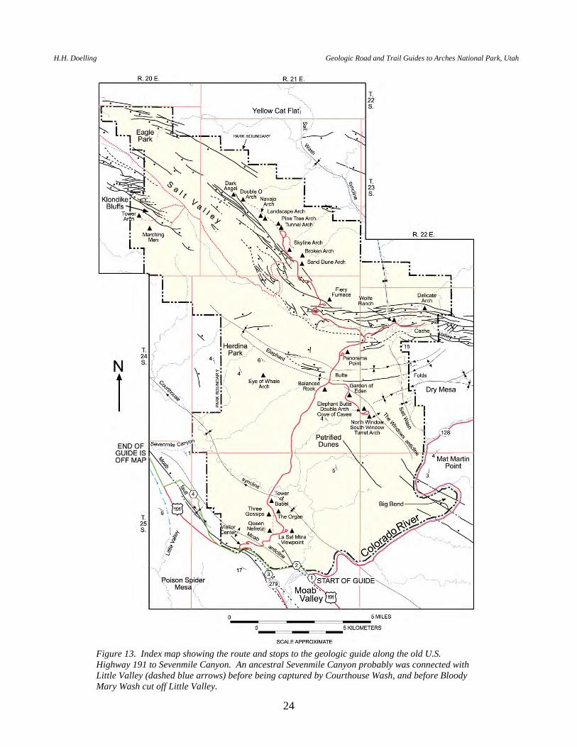
GEOLOGIC ROAD GUIDE ALONG OLD U.S. HIGHWAY 191 TO SEVENMILE CANYON
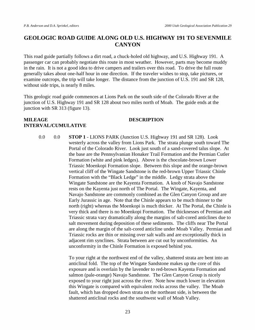
This road guide partially follows a dirt road, a chuck-holed old highway, and U.S. Highway 191. A passenger car can probably negotiate this route in most weather. However, parts may become muddy in the rain. It is not a good idea to drive campers and trailers over this road. To drive the full route generally takes about one-half hour in one direction. If the traveler wishes to stop, take pictures, or examine outcrops, the trip will take longer. The distance from the junction of U.S. 191 and SR 128, without side trips, is nearly 8 miles. This geologic road guide commences at Lions Park on the south side of the Colorado River at the junction of U.S. Highway 191 and SR 128 about two miles north of Moab. The guide ends at the junction with SR 313 (figure 13). MILEAGE DESCRIPTION INTERVAL/CUMULATIVE 0.0 0.0 STOP 1 - LIONS PARK (Junction U.S. Highway 191 and SR 128). Look
westerly across the valley from Lions Park. The strata plunge south toward The Portal of the Colorado River. Look just south of a sand-covered talus slope. At the base are the Pennsylvanian Honaker Trail Formation and the Permian Cutler Formation (white and pink ledges). Above is the chocolate-brown Lower Triassic Moenkopi Formation slope. Between this slope and the orange-brown vertical cliff of the Wingate Sandstone is the red-brown Upper Triassic Chinle Formation with the “Black Ledge” in the middle. Ledgy strata above the Wingate Sandstone are the Kayenta Formation. A knob of Navajo Sandstone rests on the Kayenta just north of The Portal. The Wingate, Kayenta, and Navajo Sandstone are commonly combined as the Glen Canyon Group and are Early Jurassic in age. Note that the Chinle appears to be much thinner to the north (right) whereas the Moenkopi is much thicker. At The Portal, the Chinle is very thick and there is no Moenkopi Formation. The thicknesses of Permian and Triassic strata vary dramatically along the margins of salt-cored anticlines due to salt movement during deposition of these sediments. The cliffs near The Portal are along the margin of the salt-cored anticline under Moab Valley. Permian and Triassic rocks are thin or missing over salt walls and are exceptionally thick in adjacent rim synclines. Strata between are cut out by unconformities. An unconformity in the Chinle Formation is exposed behind you.
To your right at the northwest end of the valley, shattered strata are bent into an
anticlinal fold. The top of the Wingate Sandstone makes up the core of this exposure and is overlain by the lavender to red-brown Kayenta Formation and salmon (pale-orange) Navajo Sandstone. The Glen Canyon Group is nicely exposed to your right just across the river. Note how much lower in elevation this Wingate is compared with equivalent rocks across the valley. The Moab fault, which has dropped down strata on the northeast side, is between the shattered anticlinal rocks and the southwest wall of Moab Valley.
H.H. Doelling Geologic Road and Trail Guides to Arches National Park, Utah
24
Figure 13. Index map showing the route and stops to the geologic guide along the old U.S. Highway 191 to Sevenmile Canyon. An ancestral Sevenmile Canyon probably was connected with Little Valley (dashed blue arrows) before being captured by Courthouse Wash, and before Bloody Mary Wash cut off Little Valley.
P.B. Anderson and D.A. Sprinkel, editors 2000 Utah Geological Association Publication 29
25
In the foreground are the Moab wetlands. As the Colorado River crosses this
part of the valley, water seeping into the subsurface dissolves salt at the top of the salt-cored anticline so that the valley slowly subsides. During flooding the river deposits alluvium in the wetlands area. Wells about one-half mile south of Lions Park indicate that at least 500 feet of alluvium has accumulated beneath the wetlands, beneath which are about 400 feet of cap rock. Cap rock is the insoluble remainder of Paradox Formation rocks from which salt has been dissolved and removed. Beneath the alluvium and cap rock is about 10,000 feet of salt-bearing rock. After stop, proceed across the Colorado River on U.S. Highway 191.
0.1 0.1 Cross Colorado River. 0.4 0.5 Cross Courthouse Wash. 0.2 0.7 Enter a parking lot on the right. STOP 2 - COURTHOUSE WASH TRAIL
HEAD. The crest of the Moab anticline lies just to your west (west of the parking lot). The core of the anticline exposes orange-brown Wingate Sandstone. The overlying red-brown to lavender rocks are Kayenta Formation, and the orange-brown Navajo Sandstone makes up the remainder of the outcrop. Look southeast across the wetlands to the town of Moab. Notice how much higher strata in the right valley wall are than equivalent strata in the left wall. This is caused by the displacement on the Moab fault. This fault cannot be traced through the valley either at the surface or by wells in the subsurface because salt movement at depth has destroyed the fault surface. Under the valley is 9,000 to 10,000 feet of salt, with the top of the salt about 900 feet beneath you.
About 200 feet to the east, the Courthouse Wash Trail crosses a fault that
juxtaposes Kayenta Formation against Chinle Formation. The color of the Chinle is about the same as that of the Kayenta, so keep a sharp eye. The relationships are more easily recognized by hiking another 150 feet to the end of the short ridge to your left and then hiking up the ridge back to the fault.
From the parking lot you should be able to see the portal of a railroad tunnel to
the west. It is just beneath the pink and white beds of the Cutler Formation. Above the pink and white beds are the chocolate-brown beds of the Moenkopi Formation. Note down-faulted slivers of Moenkopi and Chinle beds beneath the railroad cut. A branch of the Moab fault parallels the railroad tracks.
The Atlas uranium mill site is on the north side of the river to the southwest. At
the present (2000), the old terraced tailings pile and pond (now covered) beyond it, and a tin shack are all that remain. The tailings will soon be moved to another location and buried. After stop, return to U.S. Highway 191.
0.1 0.8 Back on U.S. Highway 191. Head west, then north.
H.H. Doelling Geologic Road and Trail Guides to Arches National Park, Utah
26
0.5 1.3 Junction, turn left onto SR 279. 0.1 1.4 Pull off on right side of road. STOP 3 - RAILROAD CUT. At this point you
are approximately on the main branch of the Moab fault. Walk up the hill to the railroad cut to view the west branch of the Moab fault. As you walk up you will be in Moenkopi Formation lodged in the slice between the main and west branches of the fault. At the road cut, attenuated and sheared outcrops of the Cutler and Honaker Trail Formations mask Honaker Trail outcrops on the far side of the fault. The sheared rocks dip steeply east parallel to the fault, whereas the typical dip on the Moab anticline in this area is about 15 degrees to the southwest. The dip on the Moab west branch fault is about 35 degrees east at the railroad. After the stop, return to the vehicle and return to U.S. Highway 191.
0.2 1.6 Junction, U.S. Highway 191. Turn left (northwest). 0.2 1.8 Cross Bloody Mary Wash (also known as Moab Canyon Wash). 0.3 2.1 Shattered yellow-tan outcrops on the left are Entrada Sandstone that are part of
the down-thrown block of the main branch of the Moab fault. On the right is highly jointed Navajo Sandstone on the southwest flank of the Moab anticline. Note that many joints are perpendicular to the anticline and fault. These dip steeply southward and valleyward.
0.2 2.3 Note the sand pile to the left. Windblown sand is common on Entrada Sandstone
outcrops. 0.3 2.6 Junction with entrance to Arches National Park and the visitor center. See
Visitor Center to Devils Garden Loop road guide. If you wish to continue this geologic guide, continue on U.S. Highway 191.
0.3 2.9 Highway makes a broad bend through a gap in Pennsylvanian Honaker Trail
Formation. 0.3 3.2 Junction with old highway. Turn right and drive up old highway, now marking
the boundary of Arches National Park, for a short distance. As you cross the old bridge across Bloody Mary Wash (Moab Canyon Wash) you are in the lavender strata of the Cutler Formation. Similar strata are also visible on the left across
U.S. Highway 191. Between the Cutler beds just to the right and the Entrada Sandstone high on the right is a slice of Moenkopi Formation caught between the west and the main branches of the Moab fault.
Note the rock-fall scars on the high cliff to the left. Many are historical, in
which blocks landed on railroad tracks and reached the highway. Ahead and to the left, a light pink line separates the Chinle Formation from the Moenkopi Formation.
P.B. Anderson and D.A. Sprinkel, editors 2000 Utah Geological Association Publication 29
27
0.2 3.4 A canyon opens up to the right. This is another place to view the slice of Moenkopi Formation between the two branches of the Moab fault. Immediately to the right of the road are outcrops of the Cutler Formation. Cross the west branch and you are in the thin-bedded, chocolate-brown Moenkopi Formation. Cross the main branch and you are in the light-hued Moab Member of the Curtis Formation. To the left along the wash is a nodular-weathering limestone bed in the lower part of the Cutler Formation.
0.6 4.0 At a bend in the old highway, look ahead to see nearly coherent beds of the Salt
Wash Member of the Morrison Formation that have slipped across the Moab fault on top of Cutler and Moenkopi beds. These beds look nearly concordant, with both sets dipping to the west (washward).
0.2 4.2 Road begins to gradually rise in elevation. The thin limestone in the Permian
Cutler Formation is now about at road level on the right side. 0.3 4.5 You are now in southwest-dipping Cutler Formation. Note slices of the light-
hued sandstone of the Moab Member to the right high above road level. The Salt Wash Member of the Morrison Formation lies beyond the fault.
0.2 4.7 The swale of reddish rocks east of a Moab Member slice consists of the
Summerville Formation and Tidwell Member of the Morrison Formation faulted against the Salt Wash Member of the Morrison Formation. Lavender rocks to the left in the Cutler Formation are arkosic and subarkosic (contain considerable quantities of feldspar).
0.4 5.1 STOP 4 - HONAKER TRAIL FORMATION AND MOAB FAULT. Grayish
rocks mark the top of the Pennsylvanian Honaker Trail Formation. At this location the Honaker Trail consists of limestone beds and subarkosic sandstone. Honaker Trail limestone beds are fossiliferous and contain brachiopods, bryozoans, horn corals, and rare fusulinids and trilobites. An orange and white mottled sandstone bed marks the base of the Cutler Formation. Above, a thin limestone bed in the Cutler forms a bench.
Beyond the bench, across U.S. Highway 191, is a break in the Wingate
Sandstone cliff. This is the head of Little Valley, a beheaded valley that flows southwesterly. The well-developed valley was once connected with Sevenmile Wash, but Bloody Mary Wash (Moab Canyon Wash) pirated the stream, after which a tributary of Courthouse Wash pirated Sevenmile Wash (figure 13).
Walk a little farther along the old highway into the gap. Look at the Moab fault.
It is nearly vertical here and consists of a zone of fault gouge. Rocks on the northeast side are Salt Wash Member of the Morrison Formation. After crossing the cattle-guard, the road follows a "V" syncline in which beds dip toward the road in both directions. Minor fault displacement is suspected along the axis. The syncline plunges from both ends towards the drainage that exits at the Moab fault exposure. Return to the vehicle and drive up the plunge of the "V"
H.H. Doelling Geologic Road and Trail Guides to Arches National Park, Utah
28
syncline. 0.4 5.5 You may want to stop here and walk a short distance to the left and recross the
Moab fault. You will also get another view across U.S. Highway 191 at beheaded Little Valley.
0.3 5.8 The road rises onto an old surface covered by mixed eolian and alluvial deposits
(Qea on figure 3b). Look north to the mouth of Sevenmile Canyon. The drainage coming out of that canyon once flowed on a slightly higher surface to approximately this location, then down Little Valley. Bloody Mary Gulch continues to erode headward into the old surface and may eventually divert Sevenmile Canyon wash this way.
The dirt road to the right provides access through the Salt Wash Member of the
Morrison Formation to underlying exposures of the Tidwell Member of the Morrison, Summerville Formation, and Moab Member of the Curtis Formation on the Moab anticline. Several low-displacement faults parallel the Moab anticline in the area traversed by the road to the right. Continue down the main road.
0.3 6.1 The base of the Salt Wash bluffs to the right marks the trace of the Moab fault.
Reddish rocks to its left are Permian Cutler Formation. We are still on the old alluvial and eolian surface as we cross a natural-gas pipeline.
0.1 6.2 Junction, turn left toward U.S. Highway 191. 0.1 6.3 Junction, turn right on U.S. Highway 191 (this junction has been moved since
the road guide was prepared; thus, the mileage will be different). 0.3 6.6 Junction to left with Little Valley road (partly a four-wheel, high-clearance
vehicle road and a favorite for bicyclists). Continue ahead (north) on U.S. Highway 191.
0.9 7.5 The Moab fault crosses the highway and will now be to your left. 0.2 7.7 Junction with SR 313 (left) providing access to Canyonlands National Park and
Dead Horse Point State Park. END OF GUIDE
P.B. Anderson and D.A. Sprinkel, editors 2000 Utah Geological Association Publication 29
29
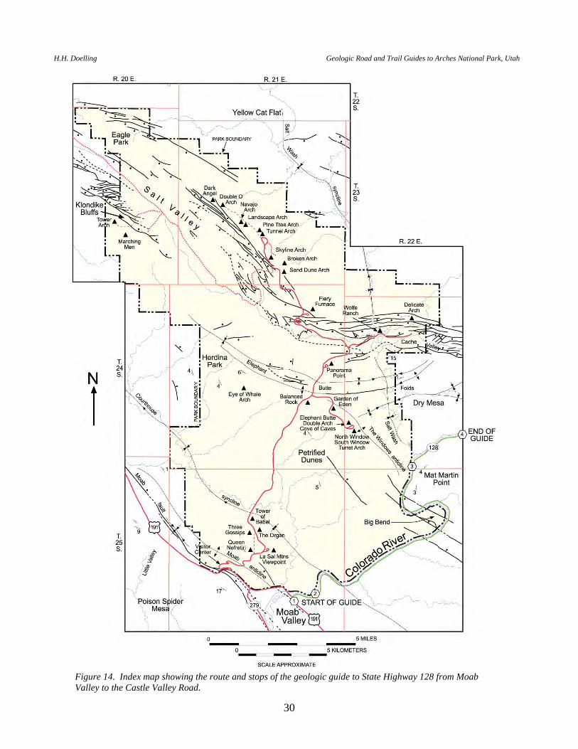
GEOLOGIC ROAD GUIDE ALONG STATE HIGHWAY 128 FROM U.S. HIGHWAY 191 TO THE CASTLE VALLEY ROAD
This road guide is run along a state highway and is easily traversed in a passenger car. To run the full road guide generally takes 45 minutes in one direction. If the traveler wishes to stop, take pictures, or examine outcrops, the trip will take longer. The distance to the Castle Valley road, without side trips is about 16 miles. This guide commences at the junction of U.S. Highway 191 and State Road 128, and heads east to the junction of SR 128 and the Castle Valley road (figure 14). Along most of the route, the river forms the southern boundary of Arches National Park. MILEAGE DESCRIPTION INTERVAL/CUMULATIVE 0.0 0.0 Junction of U.S. Highway 191 and SR 128. STOP 1 - LIONS PARK. The
north bank or far side of the Colorado River is in Arches National Park. The red-brown rocks at the road level and to the right of the highway are Upper Triassic Chinle Formation. The upper part of this formation represents the first sediment deposited over the Pennsylvanian to Triassic Moab Valley salt wall, or perhaps the first that was not eroded away after another injection of salt into the wall. The Chinle strata are much thinner over the salt-cored anticline; the transformation from thin to thick deposition was accomplished by unconformities. An unconformity can be seen in the Chinle strata to the right of the highway. See if you can pick it out.
Orange-brown, cliff-forming sandstone on both sides of the Colorado River is the Wingate Sandstone. Best viewed on the north side of the river, these rocks are overlain by the Kayenta Formation. It is distinguished by desert-varnished ledges and red-brown color. The top of the Kayenta is softer and forms a bench, on top of which is the massive, orange-brown Navajo Sandstone. All dip northeastward as the highway enters the canyon. After stop, proceed east on SR 128.
0.1 0.1 The Chinle Formation rocks dip under road level; and are replaced by the
Wingate Sandstone. 0.1 0.2 Matrimony Spring to right. This is a favorite spot for tourists to fill their water
bottles. The spring emerges near the base of the Wingate Sandstone above the impermeable Chinle Formation. Springs are present all along the northeast rim rocks of Moab Valley and some, to the southwest, have been "captured" to provide culinary water for the town of Moab. There is a legend indicating that if you drink from the spring you will always return.
0.3 0.5 The Wingate Sandstone dips beneath road level; outcrops of the Kayenta
Formation are now at road level.
H.H. Doelling Geologic Road and Trail Guides to Arches National Park, Utah
30
Figure 14. Index map showing the route and stops of the geologic guide to State Highway 128 from Moab Valley to the Castle Valley Road.
P.B. Anderson and D.A. Sprinkel, editors 2000 Utah Geological Association Publication 29
31
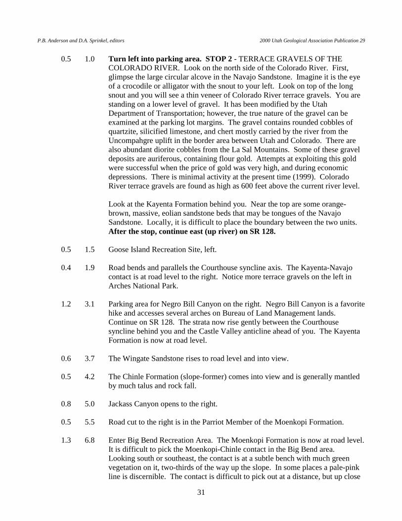
0.5 1.0 Turn left into parking area. STOP 2 - TERRACE GRAVELS OF THE COLORADO RIVER. Look on the north side of the Colorado River. First, glimpse the large circular alcove in the Navajo Sandstone. Imagine it is the eye of a crocodile or alligator with the snout to your left. Look on top of the long snout and you will see a thin veneer of Colorado River terrace gravels. You are standing on a lower level of gravel. It has been modified by the Utah Department of Transportation; however, the true nature of the gravel can be examined at the parking lot margins. The gravel contains rounded cobbles of quartzite, silicified limestone, and chert mostly carried by the river from the Uncompahgre uplift in the border area between Utah and Colorado. There are also abundant diorite cobbles from the La Sal Mountains. Some of these gravel deposits are auriferous, containing flour gold. Attempts at exploiting this gold were successful when the price of gold was very high, and during economic depressions. There is minimal activity at the present time (1999). Colorado River terrace gravels are found as high as 600 feet above the current river level.
Look at the Kayenta Formation behind you. Near the top are some orange-
brown, massive, eolian sandstone beds that may be tongues of the Navajo Sandstone. Locally, it is difficult to place the boundary between the two units. After the stop, continue east (up river) on SR 128.
0.5 1.5 Goose Island Recreation Site, left. 0.4 1.9 Road bends and parallels the Courthouse syncline axis. The Kayenta-Navajo
contact is at road level to the right. Notice more terrace gravels on the left in Arches National Park.
1.2 3.1 Parking area for Negro Bill Canyon on the right. Negro Bill Canyon is a favorite
hike and accesses several arches on Bureau of Land Management lands. Continue on SR 128. The strata now rise gently between the Courthouse syncline behind you and the Castle Valley anticline ahead of you. The Kayenta Formation is now at road level.
0.6 3.7 The Wingate Sandstone rises to road level and into view. 0.5 4.2 The Chinle Formation (slope-former) comes into view and is generally mantled
by much talus and rock fall. 0.8 5.0 Jackass Canyon opens to the right. 0.5 5.5 Road cut to the right is in the Parriot Member of the Moenkopi Formation. 1.3 6.8 Enter Big Bend Recreation Area. The Moenkopi Formation is now at road level.
It is difficult to pick the Moenkopi-Chinle contact in the Big Bend area. Looking south or southeast, the contact is at a subtle bench with much green vegetation on it, two-thirds of the way up the slope. In some places a pale-pink line is discernible. The contact is difficult to pick out at a distance, but up close
H.H. Doelling Geologic Road and Trail Guides to Arches National Park, Utah
32
the fluvial beds of the Chinle are quite different from the thin, rippled, tidal-flat deposits of the Moenkopi. The ledge in the middle of the Chinle Formation (halfway between the subtle bench and the Wingate cliff) is a unit called the Black Ledge. Note the joints in the Wingate Sandstone; some have a small amount of displacement. Continue around the Big Bend campgrounds.
0.3 7.1 Hal Canyon camp. 0.1 7.2 Oak Canyon camp. 0.4 7.6 A parking area and a short side canyon open up to the right. 0.3 7.9 The single cliff wall straight ahead is composed of all three formations, Wingate,
Kayenta, and Navajo, that make up the Glen Canyon Group. Because of the 180 degree turn at the Big Bend of the Colorado River, the road again proceeds toward the axis of the Courthouse syncline.
0.6 8.5 The light-gray-pink ledges on the left side of the highway across the Colorado
River mark the Moenkopi-Chinle contact. Note the fault displacement in the Wingate Sandstone high on the cliff to the right.
0.4 8.9 Highway swings to the right and road cuts are in the Parriot (uppermost)
Member of the Moenkopi Formation. 0.3 9.2 A fault is in view straight ahead, across and high above the river. 0.4 9.6 A canyon opens on the left side of the river. 0.7 10.3 Parking area to the left used to take river runners off the river. 0.6 10.9 STOP 3 - CHINLE FORMATION UNCONFORMITY. Carefully turn off into
a small parking area on the left side of the highway. Look across the river at the unconformity between the lower and upper parts of the Chinle Formation. The Chinle is very thick here and the lower part (under the unconformity) increases in thickness northward. This is the unusually thick rim syncline area adjacent to a salt anticline. The angle between the beds above and below the unconformity is as much as 17 degrees. The Chinle is over 700 feet thick at this location. The normal Chinle thickness is between 250 and 400 feet. If you have time, cross the highway on foot and hike up a short gulch. In this area, the Chinle displays mottled siltstone beds, which are paleosols (ancient soils) containing vertical root casts. Note the terrace gravel on the opposite side of the highway. The mesa to the right of the highway (southeast) is Mat Martin Point. The narrow canyon across the river just upstream is Salt Wash, which drains Salt Valley, the main collapsed anticline in the park. Salt Wash canyon opens up to the north. The mesa across the river and to the right of Salt Wash is Dry Mesa. At this point the national-park boundary leaves the river and extends north; most of Dry Mesa is not in the park. The vertical cliffs of Dry Mesa and Mat Martin Point are
P.B. Anderson and D.A. Sprinkel, editors 2000 Utah Geological Association Publication 29
33
Wingate Sandstone overlain by ledgy Kayenta sandstone beds. The light-hued massive sandstone at the very top of Dry Mesa is the Navajo Sandstone. Carefully return to SR 128 and proceed left (up river).
0.2 11.1 Mouth of Salt Wash to your left. The rapids in the Colorado River just below
the mouth are the Salt Wash Rapids and are caused by alluvial debris washed out of the side canyon. To the right note the mottled coloration caused by more paleosols in the north-dipping lower Chinle beds.
1.0 12.1 Note the flat beds in the Wingate in the left wall after passing a small re-entrant. 1.1 13.2 Note the rising lower Chinle beds on the left with Moenkopi Formation rising
beneath. The entire lower Chinle thins as we get closer to the next salt anticline. 0.4 13.6 The canyon opens up into Professor Valley. 0.2 13.8 Highway veers right. Colorado River floods have washed out this section of SR
128 from time to time. At times the river has been nearly as high as the highway. Rapids below are Whites Rapids.
0.1 13.9 Rise in highway. Ahead to the right is the southwest rim of the Castle Valley
salt-cored anticline, with the Wingate Sandstone at the top. Note that local scallops or shallow swales have eroded into the Wingate. These are ancient channels of streams that were tributary to the Colorado River, and were cut when the river was much higher and Castle Valley had not yet collapsed due to salt dissolution. The ranch area to the left with the cottonwood trees was used by Hollywood filmmakers. It was the site of a movie set fort used in filming a Victor McLaglen, Maureen O'Hara, and John Wayne film in the 1950s. Straight ahead, blocking the view of Castle Valley, is Hill 5163, which mostly consists of a thick section of the Moenkopi Formation. The highest point on this hill is 5,163 feet above sea level and is capped by the lowermost beds of the Chinle Formation.
1.1 15.0 Cross Castle Valley Wash. Note the gypsiferous beds to the right as the highway
drops stratigraphically into the Ali Baba Member of the Moenkopi Formation (in the bluffs to the right of the road).
0.2 15.2 Note the flexure in the Moenkopi strata to the right. 0.5 15.7 STOP 4 - CASTLE VALLEY HIGHWAY JUNCTION. Find a place to pull off
the road. To the southeast of the junction is Parriot Mesa. Look at Hill 5163 to the southwest and the flexure bending the Moenkopi Formation. The slope in the Moenkopi Formation, north of SR 128 and the Colorado River, is the Sewemup (Sew-em-up) Member. The thick ledge above the slope and the ledgy rocks below the whitish band form the Parriot Member of the Moenkopi Formation. The white band is all that remains of the lower member of the Chinle Formation. Above is the Church Rock Member of the Chinle, the cliff-
H.H. Doelling Geologic Road and Trail Guides to Arches National Park, Utah
34
forming Wingate Sandstone, and a little Kayenta Formation on top. The Moenkopi is very thick here, more than 1,000 feet, because it occupies a rim syncline between the Cache Valley and Castle Valley salt-cored anticlines. The normal thickness of the Moenkopi is about 300 to 500 feet in this part of Grand County. To the northeast across the river, at the east end of the Cache Valley salt-cored anticline, you can see rubbly, fractured Wingate Sandstone collapsed nearly to the floor of Professor Valley.
END OF GUIDE. You can return to the starting point, or, if you wish, continue up SR 128 to
access Fisher Valley, Fisher Towers, Dewey townsite with historic Dewey Bridge, and eventually Interstate Highway 70 at Cisco. Or, you may continue up the Castle Valley Highway into Castle Valley to obtain views of the Priest and Nuns, Castle Rock, and Round Mountain. The Castle Valley Highway connects with the La Sal Mountains Loop Road.
P.B. Anderson and D.A. Sprinkel, editors 2000 Utah Geological Association Publication 29
35
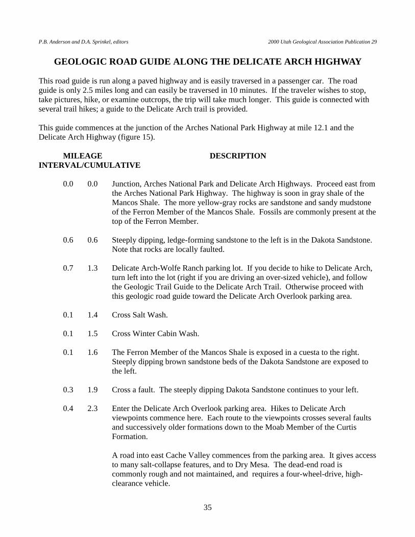
GEOLOGIC ROAD GUIDE ALONG THE DELICATE ARCH HIGHWAY This road guide is run along a paved highway and is easily traversed in a passenger car. The road guide is only 2.5 miles long and can easily be traversed in 10 minutes. If the traveler wishes to stop, take pictures, hike, or examine outcrops, the trip will take much longer. This guide is connected with several trail hikes; a guide to the Delicate Arch trail is provided. This guide commences at the junction of the Arches National Park Highway at mile 12.1 and the Delicate Arch Highway (figure 15). MILEAGE DESCRIPTION INTERVAL/CUMULATIVE 0.0 0.0 Junction, Arches National Park and Delicate Arch Highways. Proceed east from
the Arches National Park Highway. The highway is soon in gray shale of the Mancos Shale. The more yellow-gray rocks are sandstone and sandy mudstone of the Ferron Member of the Mancos Shale. Fossils are commonly present at the top of the Ferron Member.
0.6 0.6 Steeply dipping, ledge-forming sandstone to the left is in the Dakota Sandstone.
Note that rocks are locally faulted. 0.7 1.3 Delicate Arch-Wolfe Ranch parking lot. If you decide to hike to Delicate Arch,
turn left into the lot (right if you are driving an over-sized vehicle), and follow the Geologic Trail Guide to the Delicate Arch Trail. Otherwise proceed with this geologic road guide toward the Delicate Arch Overlook parking area.
0.1 1.4 Cross Salt Wash. 0.1 1.5 Cross Winter Cabin Wash. 0.1 1.6 The Ferron Member of the Mancos Shale is exposed in a cuesta to the right.
Steeply dipping brown sandstone beds of the Dakota Sandstone are exposed to the left.
0.3 1.9 Cross a fault. The steeply dipping Dakota Sandstone continues to your left. 0.4 2.3 Enter the Delicate Arch Overlook parking area. Hikes to Delicate Arch
viewpoints commence here. Each route to the viewpoints crosses several faults and successively older formations down to the Moab Member of the Curtis Formation.
A road into east Cache Valley commences from the parking area. It gives access
to many salt-collapse features, and to Dry Mesa. The dead-end road is commonly rough and not maintained, and requires a four-wheel-drive, high-clearance vehicle.
H.H. Doelling Geologic Road and Trail Guides to Arches National Park, Utah
36
END OF GUIDE
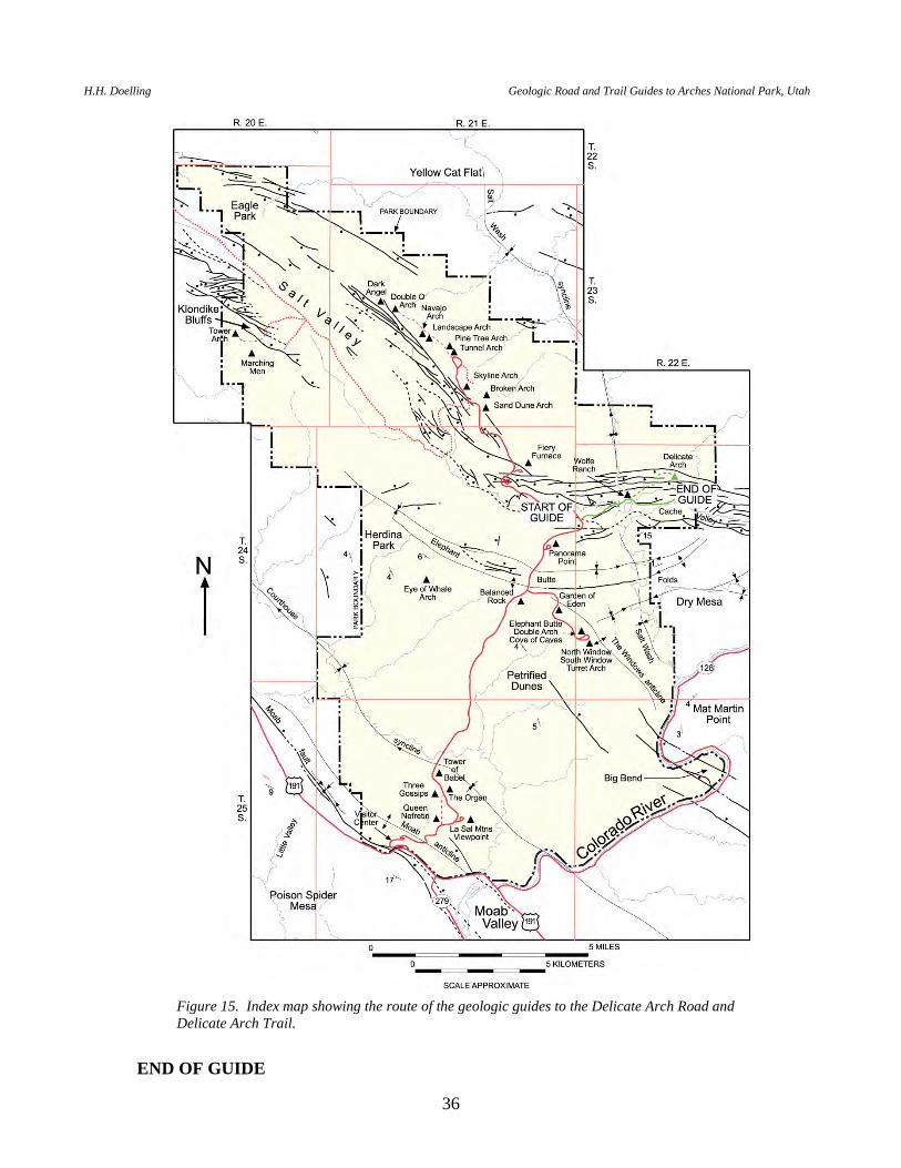
Figure 15. Index map showing the route of the geologic guides to the Delicate Arch Road and Delicate Arch Trail.
P.B. Anderson and D.A. Sprinkel, editors 2000 Utah Geological Association Publication 29
37
GEOLOGIC TRAIL GUIDE TO DELICATE ARCH The length of this hike is 1.5 miles one way (figure 15). Remember to stay on the trails and bare rock. The messy lenticular sandstone beds as you begin your walk to the arch are Salt Wash Member of the Morrison Formation. Pass old log buildings of the Wolfe Ranch to your left. Displayed are an old settler's cabin, an accessory building, a wagon, and a corral. As you cross the bridge over Salt Wash, note the gritty and pebbly conglomeratic sandstone of the Salt Wash Member of the Morrison Formation. These sandstone beds represent Upper Jurassic river channel deposits. Red and green silty mudstone (overbank deposits) are interlayered with the conglomeratic sandstone (to the right after crossing the bridge). Cross unconsolidated Quaternary deposits. Trail veers to the left and proceeds up the dip slope of the Salt Wash Member. Then the trail turns right (east), still in sandstone and siltstone beds of the Salt Wash Member. Just before the trail descends to cross a tributary drainage, look at the steep sandy slope of a ridge to your right. The sand covers green slope-forming siltstone and claystone of the Brushy Basin Member of the Morrison Formation. The rocks on both sides of the drainage ahead of you (Winter Camp Wash) are Salt Wash Member. Look left at the orange-brown rocks on the skyline. These rocks are Moab Member of the Curtis Formation. Notice the seep plane at their base. Some Slick Rock Member of the Entrada Sandstone is visible below the seep plane. Descend and cross the tributary drainage, all in the Salt Wash Member. Trail rises again. In the first rise the trail drops stratigraphically into the Tidwell Member of the Morrison Formation. It consists mostly of red siltstone with thin calcareous sandstone and limestone. Turn into the next tributary drainage developed in the Tidwell Member. Note the large siliceous concretions found near its base. Just before crossing the drainage, you pass near outcrops of the Summerville Formation. It is similar in overall appearance to the Tidwell Member, but it is noncalcareous and consists of thin silty brown sandstone beds that, here, are only 6 to 15 feet thick. The trail crosses the tributary wash on bare-rock sandstone of the Moab Member (Curtis Formation). Just left (upstream side) of the bare rock outcrop as you cross the wash is a fault with a displacement of no more than 20 feet, which drops the Tidwell down against the Moab Member. The trail rises in elevation and stratigraphically into outcrops of the Summerville and Tidwell. Note the scattered siliceous concretions in the Tidwell. At the top of the rise, look left (north) at the seep planes. The smooth-weathering, orange-brown, slick-rock sandstone is the Slick Rock Member of the Entrada Sandstone. Another fault, which parallels the cliff-face to the left, is found between the Slick Rock Member outcrop and outcrops of the Moab-Summerville-Tidwell on our side of the fault block. Continue on the trail in the Tidwell Member.
H.H. Doelling Geologic Road and Trail Guides to Arches National Park, Utah
38
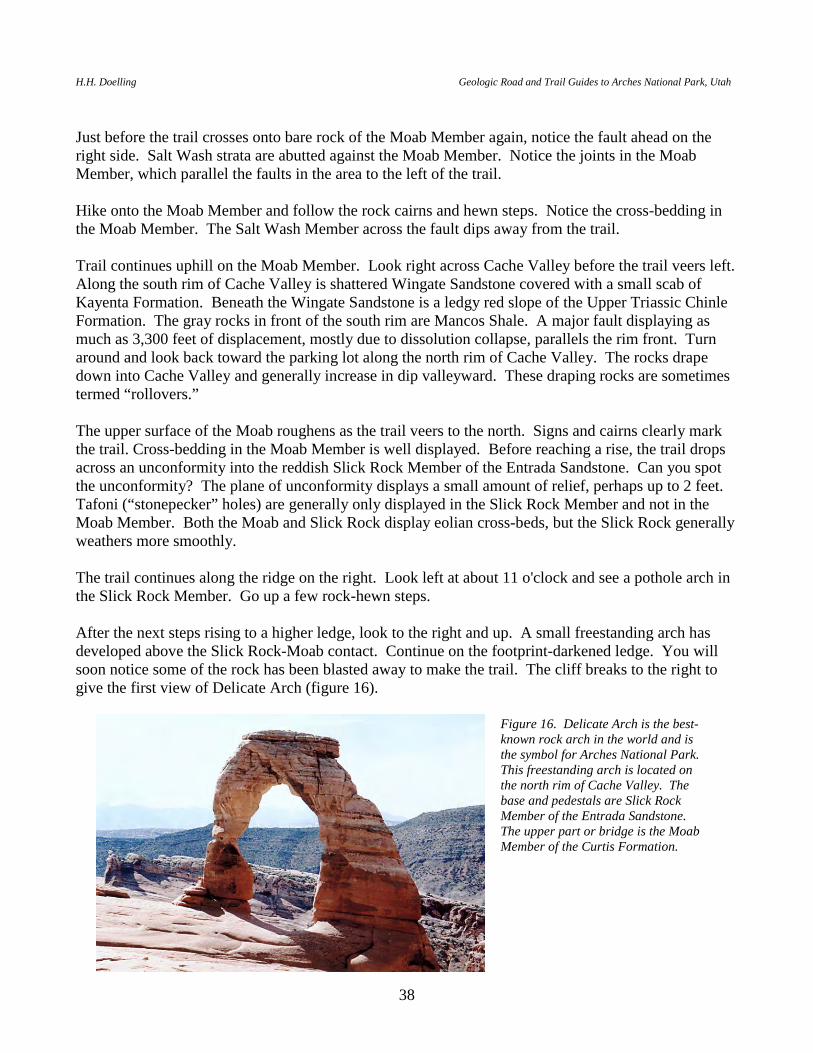
Just before the trail crosses onto bare rock of the Moab Member again, notice the fault ahead on the right side. Salt Wash strata are abutted against the Moab Member. Notice the joints in the Moab Member, which parallel the faults in the area to the left of the trail. Hike onto the Moab Member and follow the rock cairns and hewn steps. Notice the cross-bedding in the Moab Member. The Salt Wash Member across the fault dips away from the trail. Trail continues uphill on the Moab Member. Look right across Cache Valley before the trail veers left. Along the south rim of Cache Valley is shattered Wingate Sandstone covered with a small scab of Kayenta Formation. Beneath the Wingate Sandstone is a ledgy red slope of the Upper Triassic Chinle Formation. The gray rocks in front of the south rim are Mancos Shale. A major fault displaying as much as 3,300 feet of displacement, mostly due to dissolution collapse, parallels the rim front. Turn around and look back toward the parking lot along the north rim of Cache Valley. The rocks drape down into Cache Valley and generally increase in dip valleyward. These draping rocks are sometimes termed “rollovers.” The upper surface of the Moab roughens as the trail veers to the north. Signs and cairns clearly mark the trail. Cross-bedding in the Moab Member is well displayed. Before reaching a rise, the trail drops across an unconformity into the reddish Slick Rock Member of the Entrada Sandstone. Can you spot the unconformity? The plane of unconformity displays a small amount of relief, perhaps up to 2 feet. Tafoni (“stonepecker” holes) are generally only displayed in the Slick Rock Member and not in the Moab Member. Both the Moab and Slick Rock display eolian cross-beds, but the Slick Rock generally weathers more smoothly. The trail continues along the ridge on the right. Look left at about 11 o'clock and see a pothole arch in the Slick Rock Member. Go up a few rock-hewn steps. After the next steps rising to a higher ledge, look to the right and up. A small freestanding arch has developed above the Slick Rock-Moab contact. Continue on the footprint-darkened ledge. You will soon notice some of the rock has been blasted away to make the trail. The cliff breaks to the right to give the first view of Delicate Arch (figure 16).
Figure 16. Delicate Arch is the best-known rock arch in the world and is the symbol for Arches National Park. This freestanding arch is located on the north rim of Cache Valley. The base and pedestals are Slick Rock Member of the Entrada Sandstone. The upper part or bridge is the Moab Member of the Curtis Formation.
P.B. Anderson and D.A. Sprinkel, editors 2000 Utah Geological Association Publication 29
39
Look north at the pothole arch once more. A short distance to its left is another in the making. Notice large mudcrack-shaped features below the pothole arches. Look northwest at numerous joints developed in the Moab Member (light sandstone on red Slick Rock Member). The reddish mounds on sand-covered sandstone to the north are the Tidwell-Summerville interval. Walk so that you are directly east of the east pedestal of Delicate Arch and look south. In the Winter Cabin Wash drainage, see an abandoned rincon (an abandoned meander). Across the drainage is the Slick Rock Member with a Moab Member cap. Some scabs of Summerville Formation can be seen on the Moab cap. Across Cache Valley on the skyline is the Kayenta Formation, below which is a shattered Wingate Sandstone cliff, with a slightly ledgy reddish Chinle slope below. The gray rocks in the middle of Cache Valley are the Upper Cretaceous Mancos Shale. Salt Wash is the large wash to the southwest. Across the south portal of Salt Wash, the Wingate Sandstone dips southward into the Elephant Butte folds. On the skyline is Elephant Butte and the Windows arches. Before leaving Delicate Arch, see if you can pick the contact between the Slick Rock and Moab Members in the arch. The contact is just above the narrowest part of the east pedestal. Take advantage of a good view looking west toward Salt Valley. Notice the rollover of Mesozoic rocks on the north side of the valley. After viewing the arch, return to the parking area. END OF GUIDE
H.H. Doelling Geologic Road and Trail Guides to Arches National Park, Utah
40
GEOLOGIC ROAD GUIDE ALONG THE WINDOWS HIGHWAY This road guide is run along a paved highway and is easily traversed in a passenger car. The road guide is only 2.7 miles long and can easily be traversed in 10 minutes. If the traveler wishes to stop, take pictures, hike, or examine outcrops, the trip can take much longer. This guide commences at the loop at the end of the Windows Highway near the North and South Windows Arches, and travels towards the main Arches National Park Highway, because it is more convenient to see features traveling in this direction (figure 17). To reach the starting point, leave the Arches National Park Highway at milepost 9.7 and drive to the loop. MILEAGE DESCRIPTION INTERVAL/CUMULATIVE 0.0 0.0 Start at the beginning of the parking loop facing the large window arches.
STOP 1 - WINDOWS ARCHES. Note the irregularly contorted lumpy bedding in the Dewey Bridge Member of the Carmel Formation. Take a short trail to North Window, South Window, and Turret Arches (about a mile hike to and from arches; figure 18). Erosion of the softer Dewey Bridge Member out from under the Slick Rock Member of the Entrada Sandstone formed these arches.
0.2 0.2 STOP 2 - PARADE OF ELEPHANTS parking. Take a short hike to see Double
Arch (about one-half mile round trip; figure 19). 0.2 0.4 End of parking loop; drive toward Arches National Park Highway. 0.2 0.6 STOP 3 - COVE OF CAVES. If possible pull off to the right. Notice a deeply
incised gully in the Slick Rock Member over each alcove, giving the indication that alcove formation is related to gully erosion above. There are some arches here as well and all are developed along the contact between the Slick Rock Member and the Dewey Bridge Member. The road is on the Navajo Sandstone.
0.4 1.0 Beautiful large-scale, high-angle cross-beds in the Navajo to the right (figure
20). 0.3 1.3 STOP 4 - GARDEN OF EDEN. Turn right to the Garden of Eden parking area.
Look at Ham Rock to the west across the Windows Highway. Note the contorted strata of the Dewey Bridge Member forming a small syncline. Take time to discover the Dewey Bridge-Navajo contact, which is nearly at the parking area level. This contact is well displayed below Ham Rock under the contorted dark-red-brown Dewey Bridge strata. The lower part of the Dewey Bridge consists of flat beds resting on somewhat lighter and more rounded outcrops of Navajo Sandstone. Return to the main road.
0.3 1.6 At main road, turn right on Navajo Sandstone. 0.5 2.1 Small pin-hole arch high on Ham Rock to the left. This is a pothole arch.
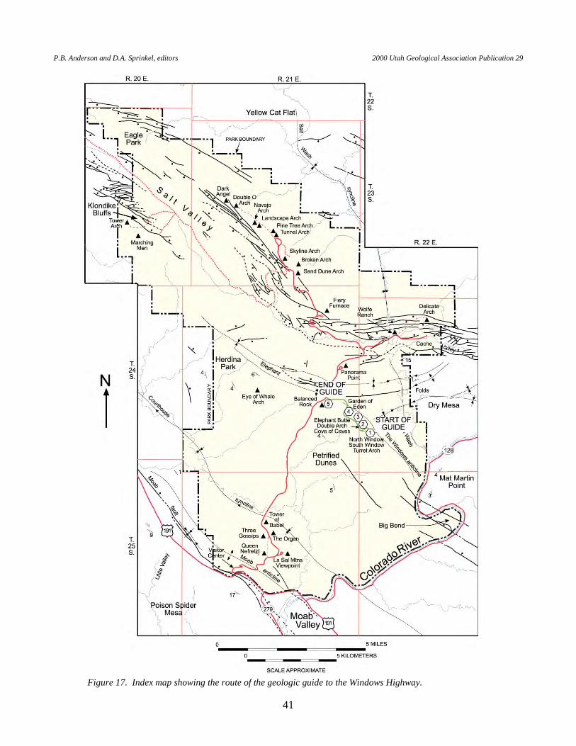
P.B. Anderson and D.A. Sprinkel, editors 2000 Utah Geological Association Publication 29
41
Figure 17. Index map showing the route of the geologic guide to the Windows Highway.
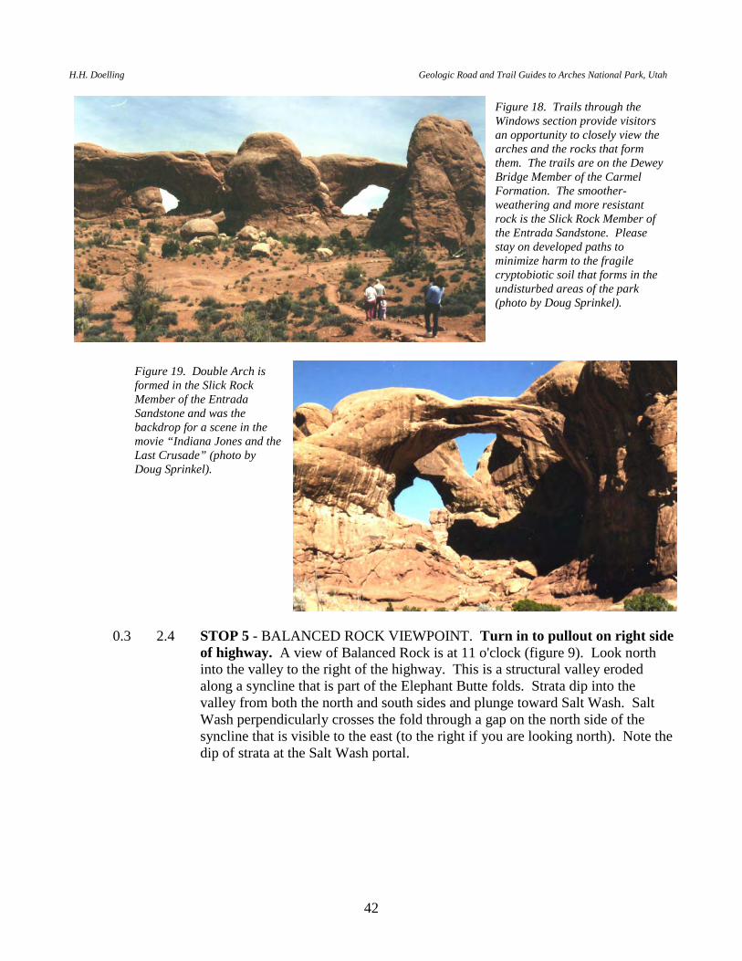
H.H. Doelling Geologic Road and Trail Guides to Arches National Park, Utah
42
0.3 2.4 STOP 5 - BALANCED ROCK VIEWPOINT. Turn in to pullout on right side of highway. A view of Balanced Rock is at 11 o'clock (figure 9). Look north into the valley to the right of the highway. This is a structural valley eroded along a syncline that is part of the Elephant Butte folds. Strata dip into the valley from both the north and south sides and plunge toward Salt Wash. Salt Wash perpendicularly crosses the fold through a gap on the north side of the syncline that is visible to the east (to the right if you are looking north). Note the dip of strata at the Salt Wash portal.
Figure 18. Trails through the Windows section provide visitors an opportunity to closely view the arches and the rocks that form them. The trails are on the Dewey Bridge Member of the Carmel Formation. The smoother-weathering and more resistant rock is the Slick Rock Member of the Entrada Sandstone. Please stay on developed paths to minimize harm to the fragile cryptobiotic soil that forms in the undisturbed areas of the park (photo by Doug Sprinkel).
Figure 19. Double Arch is formed in the Slick Rock Member of the Entrada Sandstone and was the backdrop for a scene in the movie “Indiana Jones and the Last Crusade” (photo by Doug Sprinkel).
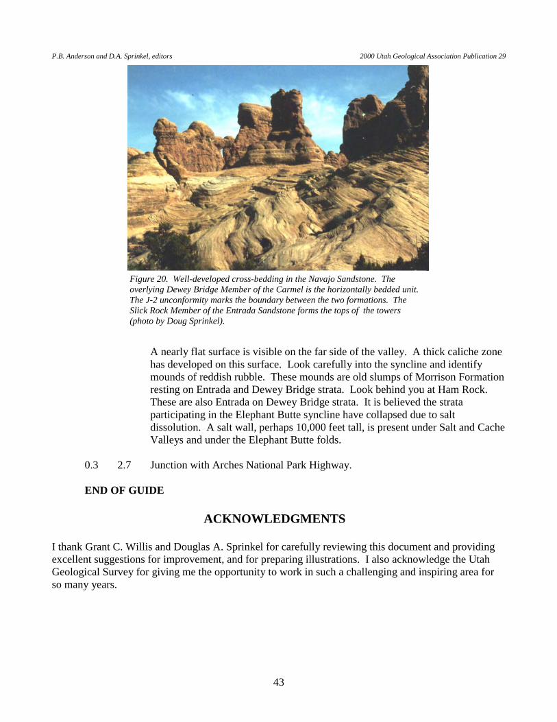
P.B. Anderson and D.A. Sprinkel, editors 2000 Utah Geological Association Publication 29
43
A nearly flat surface is visible on the far side of the valley. A thick caliche zone
has developed on this surface. Look carefully into the syncline and identify mounds of reddish rubble. These mounds are old slumps of Morrison Formation resting on Entrada and Dewey Bridge strata. Look behind you at Ham Rock. These are also Entrada on Dewey Bridge strata. It is believed the strata participating in the Elephant Butte syncline have collapsed due to salt dissolution. A salt wall, perhaps 10,000 feet tall, is present under Salt and Cache Valleys and under the Elephant Butte folds.
0.3 2.7 Junction with Arches National Park Highway. END OF GUIDE
ACKNOWLEDGMENTS
I thank Grant C. Willis and Douglas A. Sprinkel for carefully reviewing this document and providing excellent suggestions for improvement, and for preparing illustrations. I also acknowledge the Utah Geological Survey for giving me the opportunity to work in such a challenging and inspiring area for so many years.
Figure 20. Well-developed cross-bedding in the Navajo Sandstone. The overlying Dewey Bridge Member of the Carmel is the horizontally bedded unit. The J-2 unconformity marks the boundary between the two formations. The Slick Rock Member of the Entrada Sandstone forms the tops of the towers (photo by Doug Sprinkel).
H.H. Doelling Geologic Road and Trail Guides to Arches National Park, Utah
44
REFERENCES Colman, S.M., Choquette, A.F., and Hawkins, F.F., 1988, Physical, soil, and paleomagnetic
stratigraphy of the upper Cenozoic sediments in Fisher Valley, southeastern Utah: U.S. Geological Survey Bulletin 1686, 33 p.
Doelling, H.H., 1985, Geologic map of the Arches National Park and vicinity, Grand County, Utah:
Utah Geological and Mineral Survey Map 74, scale 1:50,000. Doelling, H.H., 1988, Geology of Salt Valley anticline and Arches National Park, Grand County, Utah,
in, Salt deformation in the Paradox region: Utah Geological Survey Bulletin 122, p. 7-58. Doelling, H.H., 2000, Geology of Arches National Park, Utah, in Sprinkel, D.A., Chidsey, T.C., Jr.,
and Anderson, P.B., editors, Geology of Utah’s parks and monuments: Utah Geological Association Guidebook 28, p. 11-36.
Doelling, H.H., and Ross, M.L., 1998, Geologic map of the Big Bend quadrangle, Grand County, Utah:
Utah Geological Survey Map 171, 29 p., scale 1:24,000. Doelling, H.H., Ross, M.L., and Mulvey, W.L., 1995, Interim geologic map of the Moab quadrangle,
Grand County, Utah: Utah Geological Survey Open-File Report 322, 100 p., scale 1:24,000. Gard, L.M., Jr., 1976, Geology of the north end of the Salt Valley anticline, Grand County, Utah: U.S.
Geological Survey Open-File Report 76-303, 35 p. Nelson, S.T., Heizler, M.T., and Davidson, J.P., 1992, New 40Ar/39Ar ages of intrusive rocks from the
Henry and La Sal Mountains, Utah: Utah Geological Survey Miscellaneous Publication MP 92-2, 24 p.
Oviatt, C.G., 1988, Evidence for Quaternary deformation in the Salt Valley anticline, southeastern
Utah, in, Salt deformation in the Paradox region: Utah Geological Survey Bulletin 122, p. 61-76.