Amendment Notice 2 - der.wa.gov.au a dam break study with lower contour levels would assist with...
26
Licence: L6637/1995/15 1 Licence Number L6637/1995/15 Licence Holder Electricity Generation and Retail Corporation ACN 58 673 830 106 File Number: DER2015/000109 Premises Collie ‘A’ Power Station Boys Home Road PALMER WA 6225 Being Part of Lot 3001 on Plan 51101 Date of Amendment 26 October 2017 Amendment The Chief Executive Officer (CEO) of the Department of Water and Environmental Regulation (DWER) has amended the above Licence in accordance with section 59 of the Environmental Protection Act 1986 as set out in this Amendment Notice. This Amendment Notice constitutes written notice of the amendment in accordance with section 59B(9) of the EP Act. Date signed: 26 October 2017 Jonathan Bailes A/Senior Manager Industry Regulation (Process Industries) an officer delegated under section 20 of the Environmental Protection Act 1986 (WA) Amendment Notice 2
Transcript of Amendment Notice 2 - der.wa.gov.au a dam break study with lower contour levels would assist with...

Licence: L6637/1995/15 1
Licence Number L6637/1995/15
Licence Holder Electricity Generation and Retail Corporation
ACN 58 673 830 106
File Number: DER2015/000109
Premises Collie ‘A’ Power Station
Boys Home Road
PALMER WA 6225
Being Part of Lot 3001 on Plan 51101
Date of Amendment 26 October 2017
Amendment
The Chief Executive Officer (CEO) of the Department of Water and Environmental Regulation (DWER) has amended the above Licence in accordance with section 59 of the Environmental Protection Act 1986 as set out in this Amendment Notice. This Amendment Notice constitutes written notice of the amendment in accordance with section 59B(9) of the EP Act.
Date signed: 26 October 2017
Jonathan Bailes
A/Senior Manager Industry Regulation (Process Industries)
an officer delegated under section 20 of the Environmental Protection Act 1986 (WA)
Amendment Notice 2

Licence: L6637/1995/15 2
Definitions and interpretation
Definitions
In this Amendment Notice, the terms in Table 1 have the meanings defined.
Table 1: Definitions
Term Definition
ANCOLD Australian National Committee on Large Dams
FAD Fly Ash Dam
Noise Regulations Environmental Protection (Noise) Regulations 1997 (WA)
PDWSA Public Drinking Water Source Area, as proclaimed under the Metropolitan Water Supply, Sewerage and Drainage Act 1909 or the Country Areas Water Supply Act 1947.
RL Reduced level, a relative measurement of the vertical distance between an assumed survey height reference point, and other survey data points.
VWP Vibrating Wire Piezometers, an instrument to measure water pressure within the pore spaces in soils and rocks.
Amendment Notice
This amendment is made pursuant to section 59 of the Environmental Protection Act 1986 (EP Act) to amend the Licence issued under the EP Act for a prescribed premises as set out below. This notice of amendment is given under section 59B(9) of the EP Act.
The Statements have informed the decision made on this amendment:
Guidance Statement: Regulatory Principles (July 2015)
Guidance Statement: Setting Conditions (October 2015)
Guidance Statement: Decision Making (November 2016)
Guidance Statement: Risk Assessment (November 2016)
Guidance Statement: Environmental Siting (November 2016)
Amendment description
On 11 April 2017, the Licence Holder submitted an application to amend Licence L6637/1995/15 for the Collie ‘A’ Power Station. Appendix 1 contains a list of the documents that form the Application.
The Licence Holder has applied to make the following changes:
1. To raise the embankment of the existing Fly Ash Dam (FAD) Cell 2B by 3 m to a total height of 231 mAHD;
2. To increase the approval throughput for total ash disposal from 95,000 tonnes per annum to 120,000 tonnes per annum; and
3. To construct a seepage berm wall along the western base of the FAD.

Licence: L6637/1995/15 3
This notice is limited to an amendment for Category 53: flyash disposal. No changes to other aspects of the licence relating to Category 52: electric power generation have been requested. The Licence Holder has advised that the proposed increase in flyash disposal is a result of a reduction in the quality of coal which is used as a fuel source; however, the overall amount of energy generated at the site will remain the same. Lower quality coal generates a greater amount of waste requiring disposal in the FAD including flyash, bottom ash sand, pyrite and other materials that are identified as unsuitable for combustion in the boilers (GHD, 2017a).
Table 2 below outlines the proposed changes to throughput capacity of the Licence.
Table 2: Proposed design capacity changes
Category Current Design Capacity Proposed Design Capacity
Description of proposed amendment
53 95,000 tonnes per annum 120,000 tonnes per annum
The amount of flyash and other waste requiring on-site disposal in the fly ash dam has increased
Through this amendment, the Licence Holder intends to use borrow-material currently stored in Cell 2C of the FAD to raise the embankment of Cell 2B by three meters to 231 mAHD using the upstream method of construction for tailings storage facilities (ANCOLD, 2012). A three-metre raise of associated infrastructure such as the internal causeways, decant structures, underdrainage lines, and electrical and pumping infrastructure will also occur. A new external seepage berm will be constructed to the west of Cell 2A and Cell 2B to slow down the upward movement of seepage as shown by the purple linear feature in Figure 1 below. Some modification to external drainage lines to divert stormwater away from the FAD is also included in the proposal.
Figure 1: Proposed Cell 2B embankment and causeway raise with seepage berm
Source: Drawing Number CPA-5-C-078-LY-0011-001, TW Power Service Pty Ltd: Collie Cell 2B Embankment Raise Design Report for Regulator (GHD May 2017)

Licence: L6637/1995/15 4
It is proposed that the embankment raise will provide sufficient capacity within Cell 2B for the deposition of an additional 90,000 m3 of flyash over a 24 month period across the whole FAD. The rate of flyash deposition will increase from 90,000 tonnes per annum to 120,000 tonnes per annum. The Licence Holder proposes to continue depositing flyash into Cell 2A while Cell 2B is used, allowing for a reduced rate of filling into each cell part, and for overall improved decant recovery and management.
The Delegated Officer’s assessment of the application has had specific regard to:
the protection of ground and surface water resources close to the FAD;
the design and construction methods including third-party quality assurance and testing of the FAD embankment raise; and
the operational monitoring and management of water during the operational phase of the FAD.
Other approvals
No other relevant approvals have been identified for the activities proposed in this amendment application.
Consultation
Although the FAD contains flyash rather than tailings generated from mining operations, the Delegated Officer identified that the FAD has similar characteristics in design, operation and environmental risks as tailings storage facilities regulated under the Western Australian Mining Act 1978. As such, the application was referred to the Department of Mines, Industry Regulation and Safety (DMIRS) for advice.
The internal advice provided by DMIRS noted that the FAD embankment raise is capable of meeting design criteria; however, the long-term performance of the FAD may be affected by:
the shape of the phreatic surface within the FAD;
the effective blending of embankment construction materials and the effect this blending will have on the geotechnical properties of the embankment (e.g. permeability, density, shear strength); and
the size and location of the decant pond within the FAD.
The advice also identified a number of aspects of the proposal which required detailed consideration, including:
the presence of an existing seepage pathway along the western side of the FAD (along perimeter walls of Cell 2A and Cell 2B);
the success of underdrainage systems to control the phreatic surface along and within the embankments;
the liquefiable nature of fly ash;
the diversion of surface water around the FAD during a probable maximum flood event;
the absence of berms at raise level, which can be an issue for surface water erosion and rehabilitation of the FAD;
that a dam break study with lower contour levels would assist with understanding the worsts case potential outcomes form this event (such as 0.5m);
the requirement to act on the presence of phreatic surface within the embankment;

Licence: L6637/1995/15 5
the use of multi-spigot discharge in the management of the decant pond (especially in winter and when a change in beaching is required);
the use of annual audits undertaken by a third-party geotechnical or engineering specialist to verify the FAD is performing to the required standards; and
A Trigger Action Response Plan (TARP), which ensures that each person with a role in performance monitoring and major hazard management for the FAD has been trained and assessed as being competent.
The advice provided by DMIRS has been considered in the Delegated Officer’s assessment of geotechnical embankment stability as discussed in this Amendment Notice.
Amendment history
Table 3 provides the recent amendment history and relevant works approvals for Licence L6637/1995/15.
Table 3: Licence amendments and relevant works approvals
Instrument Issued Amendment
L6637/1995/15 10/10/2014 DWER initiated amendment to convert the licence to new format, authorise operation of an embankment raise of FAD Cell 1A and incorporate requirements of the Minister for Environment’s appeal determination No. 2633/11.
W5867/2015/1 13/10/2015 Ash Storage Dam Cell 2B embankment raise
L6637/1995/15 02/06/2016 Licence Holder initiated amendment to revise licence limits for discharge to surface water via the ocean outfall and to extend the expiry date to 17 October 2036.
L6637/1995/15 06/01/2017 Amendment Notice 1
Licence Holder initiated amendment to change registered business address.
L6637/1995/15 26/10/2017 Amendment Notice 2
Licence Holder initiated amendment to construct a 3 m embankment raise on Ash Storage Dam Cell 2B and to increase the approved throughput capacity for the disposal of flyash from 95,000 tonnes per annum to 120,000 tonnes per annum.
Location and receptors
Table 4 below lists the relevant sensitive land uses in the vicinity of the prescribed premises which may be receptors relevant to the proposed amendment.

Licence: L6637/1995/15 6
Table 4: Receptors and distance from activity boundary
Residential and sensitive premises Distance from flyash dam
Rural residences
(R1, R2, R3 and R4 as depicted in Figure 1)
As measured from the boundary of the FAD (Cell 1 and Cell 2) as depicted in Figure 1:
R1 – approx. 4.6 km northwest
R2 – approx. 3.5 km northeast
R3 – approx.4.0 km northeast
R4 – approx.6.6 km southeast
Semi-Rural residential area
(SR1 as depicted in Figure 1)
SR1 – approx. 5.2 km west
Collie Hills Village Accommodation
(CHV as depicted in Figure 1)
CHV – approx.4.8 km west
The location of these receptors from the FAD is illustrated in Figure 2 below
Figure 2: Location of sensitive receptors to the premises boundary and flyash dam
Licence: L6637/1995/15 7
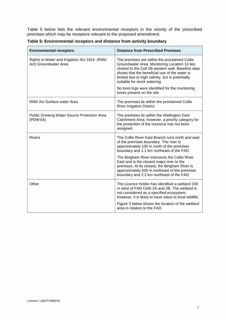
Table 5 below lists the relevant environmental receptors in the vicinity of the prescribed premises which may be receptors relevant to the proposed amendment.
Table 5: Environmental receptors and distance from activity boundary
Environmental receptors Distance from Prescribed Premises
Rights in Water and Irrigation Act 1914 (RIWI Act) Groundwater Area
The premises are within the proclaimed Collie Groundwater Area. Monitoring Location 14 lies closest to the Cell 2B western wall. Baseline data shows that the beneficial use of the water is limited due to high salinity, but is potentially suitable for stock watering.
No bore logs were identified for the monitoring bores present on the site.
RIWI Act Surface water Area The premises lie within the proclaimed Collie River Irrigation District.
Public Drinking Water Source Protection Area (PDWSA)
The premises lie within the Wellington Dam Catchment Area; however, a priority category for the protection of the resource has not been assigned.
Rivers
The Collie River East Branch runs north and east of the premises boundary. The river is approximately 100 m north of the premises boundary and 1.1 km northeast of the FAD.
The Bingham River intersects the Collie River East and is the closest major river to the premises. At its closest, the Bingham River is approximately 500 m northeast of the premises boundary and 2.2 km northeast of the FAD.
Other The Licence Holder has identified a wetland 100 m west of FAD Cells 2A and 2B. The wetland is not considered as a specified ecosystem; however, it is likely to have value to local wildlife.
Figure 3 below shows the location of the wetland area in relation to the FAD.

Licence: L6637/1995/15 8
Figure 3 Location of wetland area downstream of flyash dam
Risk assessment
Tables 6 and 7 below describe the construction, commissioning, and operational Risk Events associated with the amendment consistent with the Guidance Statement: Risk Assessments. Both tables identify the determined risk to public health or the environment from the amendment, and whether activities require further regulatory controls.

Licence: L6637/1995/15 9
Table 6: Risk assessment for proposed amendments during construction
Risk Event
Consequence rating
Likelihood rating
Risk Reasoning Source/Activities
Potential Emissions
Potential Receptors
Potential Pathway
Potential Adverse Impacts
Cat 53 Flyash
disposal
Earthworks including transport mixing, and compaction of materials for the embankment raise construction of the berm wall, internal causeway and modification to existing surface water drain
Dust: from
construction activities
Single rural dwelling, closest being 3.5 km northeast of the FAD
Air:
transport and dispersion of particulates (fugitive dust)
Health and amenity impacts
Slight Rare Low The Delegated Officer considers that the separation distance between the construction area and the residential dwellings is sufficient.
Native vegetation and wetland approximately 100 m from the FAD
Air:
transport and dispersion of particulates (fugitive dust)
Deposition on vegetation which may prevent photosynthesis and plant respiration
Slight Rare Low The Delegated Officer considers that the separation distance between the FAD and the receptor is sufficient. Construction works will be of short duration.
Noise: from
construction activities
Single rural dwelling, closest being 3.5 km northeast of FAD
Air:
transport and dispersion
Health and amenity impacts
Slight Rare Low The Delegated Officer considers that the separation distance between the construction area and the residential dwellings is sufficient. Construction works will be of short duration. The Noise Regulations apply.

Licence: L6637/1995/15 10
Risk Event
Consequence rating
Likelihood rating
Risk Reasoning Source/Activities
Potential Emissions
Potential Receptors
Potential Pathway
Potential Adverse Impacts
Sediments:
mobilised by stormwater runoff.
Collie River East within 1.1 km of the FAD Native vegetation and wetland approximately 100 m from the FAD
Land:
surface runoff
Increased sedimentation in Collie River East Smothering of vegetation
Minor Rare Low The Delegated Officer considers that the separation distance between the construction area and the residential dwellings is sufficient. Sediment discharge to the wetland and native vegetation will be mitigated by existing drains and culvert redirecting surface water runoff away from the FAD. Construction works will be of short duration

Licence: L6637/1995/15 11
Table 7: Risk assessment for proposed amendments during operation
Risk Event
Consequence rating
Likelihood rating
Risk Reasoning Source/Activities
Potential Emissions
Potential Receptors
Potential Pathway
Potential Adverse Impacts
Cat 53 Flyash disposal
Embankment failure of FAD
Flyash slurry:
approximately 30% acidic water with elevated metals and approximately 70% fine particle ash.
Native vegetation and wetland approximately 100 m from the FAD. Collie River 1000 m from the FAD. People travelling in vehicles on Boys Home Road 400 m from the FAD.
Land and water:
covering and inundation of nearby land and surface water resources; infiltration to groundwater
Injury to people travelling in vehicles on Boys Home Road. Soil contamination Loss of terrestrial and nearby aquatic ecosystems through burial. Degradation of groundwater quality impacting on beneficial use of Collie River.
Major Possible High The consequence of embankment failure is considered major due to the potential for high-level impacts on site and off site.
The likelihood is considered possible as the event could occur at any time.
Refer to the detailed risk assessment in the decision section below.
HDPE pipeline, drain and pump failures associated with transport of flyash slurry to the flyash dam and transport of recovered decant water to ash run off dam
Flyash slurry:
approximately 30% acidic water with elevated metals and approximately 70% fine particle ash. Decant/slurry water:
acidic with elevated metals, salts and metalloids.
Soil and groundwater
Land: direct
infiltration through soil profile. Groundwater:
Infiltration through soil to groundwater.
Soil contamination. Groundwater acidification contributing to a decline in beneficial use.
Moderate Possible Medium There will be no overall change in the risk of pipeline, drain and pump failures associated with the Cell 2B embankment raise.
Existing licence Conditions 1.3.5, 1.3.6 and 3.5.2 apply.
No further assessment required.

Licence: L6637/1995/15 12
Risk Event
Consequence rating
Likelihood rating
Risk Reasoning Source/Activities
Potential Emissions
Potential Receptors
Potential Pathway
Potential Adverse Impacts
Seepage of contaminants through the FAD liner causing groundwater contamination and mounding
Slurry water:
acidic with elevated metals, salts and metalloids.
Soil and Groundwater
Land: direct
infiltration through soil profile. Groundwater:
Infiltration through soil to groundwater.
Groundwater acidification contributing to a decline in beneficial use. Rise in groundwater levels causing harm to vegetation and a decline in water quality within the wetland.
Moderate Likely High The risk of seepage through the liner is considered in detailed risk assessment in the decision section below.
Stormwater contact with external embankments and area surrounding the FAD.
Dilute contaminated water: acidic with
elevated metals.
Soil and Groundwater
Land: direct
infiltration through soil profile. Groundwater:
Infiltration through soil to groundwater.
Soil and groundwater contamination
Slight Possible Low Existing diversion channels will minimise stormwater contact with the FAD and minimise sediment transport.
Stormwater erosion to the embankments and the impact of flooding are considered under embankment failure section.
No further assessment required.

Licence: L6637/1995/15 13
Risk Event
Consequence rating
Likelihood rating
Risk Reasoning Source/Activities
Potential Emissions
Potential Receptors
Potential Pathway
Potential Adverse Impacts
Overtopping due to excess loading or heavy rainfall events or both.
Flyash slurry:
Approximately 30% acidic water with elevated metals and approximately 70% fine particle ash.
Groundwater (superficial aquifer)
Groundwater:
Infiltration through soil to groundwater.
Groundwater acidification contributing to a decline in beneficial use.
Moderate Possible Medium There will be no overall change to the risk of overtopping due to excess loading or heavy rainfall events associated with the current Cell 2B
embankment raise. Existing licence Conditions 1.3.2, 1.3.3 and 1.3.4 and the existing FAD Operating Manual apply. No further assessment required.
Dust lift off from flyash at deposition surface
Flyash: containing
SiO2, Al2O3, CaO and metal particulates.
Single rural dwelling, closest being 3.5 km northeast of the FAD.
Air: transport and
dispersion of particulates (fugitive dust).
Health and amenity impacts.
Slight Rare Low There will be no overall change in the risk of dust emissions associated with the current Cell 2B embankment raise during operation. The Delegated Officer considers that the separation distance between the FAD and the residential dwellings is sufficient. No further assessment required.

Licence: L6637/1995/15 14
Risk Event
Consequence rating
Likelihood rating
Risk Reasoning Source/Activities
Potential Emissions
Potential Receptors
Potential Pathway
Potential Adverse Impacts
Contact by wildlife
Contact: Birds
exposed to potential toxins or hazardous materials from the surface of
Birdlife
Animal: direct
contact and ingestion of water with elevated metals and very low pH
Harm to birds such as soft tissue damage (eyes, digestive tract) caused by ingestion of and contact with acidic water.
Slight Rare Low There will be no overall change in the risk of harm to birds associated with the current Cell 2B embankment raise. Records indicate that there is minimal to no impacts on birds resulting from contact with the existing FAD.
No further assessment required.

Licence: L6637/1995/15 15
Embankment failure
The primary control mechanism to prevent, control, and mitigate impacts to the environment from the embankment raise is the structural integrity of the FAD. The design and construction characteristics of the embankment will determine if the dam has the ability to contain the flyash under variable operating conditions.
Although the construction and design are critical to the structural integrity of the embankments, other factors may influence stability - such as the size and extent of the saturation zone within the FAD, seepage management practices, flyash deposition, and decant recovery. Surface water run-off and flood events that inundate the base of the dam also have the ability to compromise the embankments. In the event of an embankment failure or ‘dam break’, incident impacts are likely to be significant with lasting effects spread over a large geographical area.
By-products from coal combustion have the potential to be cementitious in nature and biologically hazardous due to the presence of fine particles and leachable trace metals, metalloids, and soluble salts (Sajawan et al., 2003).
On this basis, high-level contingency and emergency response planning are required to ensure that actions taken in the case of a dam break event are timely and effective in mitigating impacts.
Embankment lift design
The Licence Holder has proposed that the FAD raise has been designed to comply with the design criteria in the ANCOLD Guidelines: Guidelines on Tailings Dams (ANCOLD 2012) and Guidelines on Consequence Categories for Dams (ANCOLD 2012b).
The 3 m raise will be undertaken in a single lift using the upstream method of construction, to a final height of 231 mAHD. The discharge of slurry will occur at the perimeter embankment to create a solid beach foundation along the outer edge of the dam. Underdrainage will be placed at the upstream toe to control the phreatic surface within the embankment and to reduce pore pressure within the deposition mass.
The embankment raise contains a seepage berm at the base of the FAD, internal causeways, decant and underdrainage lines, and pumping infrastructure. The areas in Figure 4 below show the raise areas relative to the underdrainage lines at the upstream toe of the embankments. The grey structure identified at RL215.5 m shows the relative position of the external seepage berm.
Figure 4: Upstream construction method for Cell 2B with location of underdrainage pipes indicated
Source: Figure 8.1, TW Power Service Pty Ltd: Collie Cell 2B Embankment Raise Design Report for Regulator (GHD, May 2017)

Licence: L6637/1995/15 16
The embankment design does not contain a berm at the rise level and incorporates a continuous slope of approximately 19%. The original embankment of the FAD was constructed to 225 mAHD. An initial embankment raise was completed taking the FAD to 228 mAHD. The original embankment and first raise form the foundation of the proposed second raise to 231 mAHD and the long-term stability of the FAD as a whole. Therefore, the Delegated Officer considers it appropriate to consider the characteristics and performance attributes of the current and proposed structure against the design parameters.
Construction
The Licence Holder has advised that the use of variable construction materials for the embankments using the downstream method of construction.
The borrow materials to be used include clay, sandy clay, silty sand, and gravel. Bottom ash will be used for the causeway and embankment walls. The materials used are expected to meet predetermined design criteria and will be blended and tested during construction to ensure that they possess suitable engineering properties for use in the embankments.
The accepted industry design criteria to be used in this instance are derived from the ANCOLD Guidelines and the Code of Practice for Tailings Storage Facilities in Western Australia (DMP 2013). Consideration may include compaction density, particle size distribution, shear strength, Atterberg limits, consolidation, erosion resistance, dispersion characteristics, elasticity (shrinkage), slake durability, hydraulic conductivity and resistance to liquefaction (DMP 2015).
The Licence Holder has advised that a construction report will be submitted to DWER following completion of the works and prior to commissioning of the embankment raise. This report proposes to demonstrate that the construction materials and methods have been undertaken in accordance with the design report submitted as part of the Application.
Managing seepage
Although the design and construction stages of development may meet specified design criteria, the ongoing presence of water within the embankments has the potential to cause the pore spaces between soil particles to swell, weakening the bond between the soil particles that form the containment infrastructure and potentially causing embankment failure.
The Licence Holder has commissioned modelling of scenarios under various design conditions and identified that management of the phreatic surface within the FAD through use of an underdrainage system and the position and size of decant pond were critical to the long-term stability of the entire FAD (GHD 2017b).
The Application includes a proposal to operate an underdrainage system above the clay liner at the base of the dam and at the upstream toe of each embankment raise, including at the toe of the proposed raise, to recover excess water within Cell 2B.
Figure 5 and Figure 6 below show the expected phreatic surface (dotted blue line) within Cell 2B with and without the seepage berm and underdrainage system. The construction of a seepage berm at the base of Cell 2A and Cell 2B will reduce upward seepage and piping through the embankment walls. Without these seepage management options, the stability of the embankment may be compromised.

Licence: L6637/1995/15 17
Figure 5: Phreatic surface within Cell 2B without a seepage berm or operational underdrainage system
Source: Figure 8.1, TW Power Service Pty Ltd: Collie Cell 2B Embankment Raise Design Report for Regulator (GHD May 2017)
Figure 6: Phreatic surface within Cell 2B with a seepage berm and operational underdrainage system
Source: Figure 8.1, TW Power Service Pty Ltd: Collie Cell 2B Embankment Raise Design Report for Regulator (GHD May 2017)
The discharge of slurry will occur at the perimeter embankment to create a solid beach along the external edge of Cell 2B with the decant pond located approximately 100 m from the outer embankment of the dam. The Delegated Officer considers that multi-spigot discharge will assist in managing the size and extent of the decant pond within the deposition mass, especially during wetter periods when a change to the beaching area is required.
The Application states that the FAD currently shows signs of seepage through the embankment of Cell 2A, and that this has the ability to impact the stability of the dam. By operating Cell 2A and Cell 2B concurrently, the Licence Holder proposes to reduce the deposition rate significantly into one cell at any one time while increasing the overall throughput. Although this will improve the management and recovery of the water within the slurry across both cells, the effect the presence of the phreatic surface has on the lower level embankments and the compounding effect the additional embankment raise may have on the overall stability of the FAD should be further reviewed.
During construction, six new vibrating wire piezometers (VWP) will be installed at three locations in the embankment walls of Cell 2B to monitor pore pressure within the embankments (see Figure 7 below). VWPs exist at three locations within the existing embankment walls to measure the phreatic surface within the flyash to indicate if seepage is present.

Licence: L6637/1995/15 18
Figure 7: Map of piezometer locations
The Licence Holder has advised that an updated Collie Power Station Fly Ash Dam Cell 2 Operating Manual (GHD 2015) will be submitted following construction of the works. The operating manual will include the new embankment raise and associated infrastructure and specify management actions suitable to the embankment raise as constructed and prior to commissioning.
Managing flyash deposition and decant recovery
The management of deposition of flyash slurry directly affects the extent and location of the saturation zone within the FAD and can influence the stability of embankments, even when designed and constructed to industry recognised standards (ANCOLD 2012; DMP 2013).
The Application contains provisions to ensure embankment stability is not adversely affected by flyash and decant deposition practices during the operation of the FAD; these include:
Flyash will be beached along the outer cell embankment to an operational freeboard of 300 mm allowing for storage of rainfall from a 1 in 100-year annual rainfall incident event up to 192.6 mm of rainfall over a 72 hour period;
Discharge of slurry will occur along the entire perimeter of the external embankment

Licence: L6637/1995/15 19
through a series of sub-aerially placed spigots (17 m apart) to facilitate beaching of the ash and draining of water towards a centrally located decant structure;
The beach will be carefully monitored and controlled to ensure that the inner slope adjacent to each spigot rises in maximum of 0.3 m intervals prior to the spigots being isolated and rotated every ten days to ensure even deposition and consolidation of ash along the exterior embankment;
Water from the surface of the dam will drain towards a centrally located decant structure where it can be recovered into the waste stream and will ensure pooling does not occur near the embankments;
Reduced rate of discharge into any one FAD cell at a time through concurrent deposition into Cell 2A and Cell 2B allowing for improved consolidation of ash and recovery of decant;
A seepage berm will be constructed within the cell along the western perimeter to minimize seepage contact with the outside of the embankment wall;
Six VWPs will be installed along the perimeter embankment at depths of 229 mAHD to enable monitoring of the phreatic surface within the deposition mass; and
Daily visual monitoring of the dam, embankments, and deposition infrastructure.
Probable Maximum Flood event impact
Flood waters may act as a destabilising influence on the external wall of the FAD through an initial swelling and subsequent shrinkage of pore spaces when the embankment materials become saturated then dry after the flood event.
The FAD is situated within 100m of a wetland area which is a low point within the catchment area and an area where groundwater is understood to naturally express at the ground surface. This area has the potential to flood under certain rainfall events; however, the Application has not fully assessed:
under what conditions the wetland area could flood the base of the dam and potentially compromise the foundation, saturating the structure from the external wall;
what influence the localised hydrogeology and seepage may contribute to the effects caused by a probable maximum flood event, should it intersect with the base of the FAD; and
the effects of lateral and horizontal seepage and rising groundwater beneath the FAD, which may interact to increase the impact of a probable maximum flood event.
Dam break study
Dam break studies allow the impact of a dam failure to be predicted and allow for targeted contingency and emergency response planning to be developed. In the event of embankment failure for tailings storage facilities, the decant pool is usually discharged first followed by a second wave of more solidified tailings material. The Licence Holder has advised that the fly ash contained within the dam is liquefiable, which means that the entire mass contained within the dam has the potential to be discharged as a semi-liquid, resulting in a larger impact footprint area. The dam break study included within the Application was based on modelling carried out on 5 m terrain contours.
Emergency Response Plan and Trigger Action Response Plan (TARP)
The FAD operating manual states the site has an emergency action plan, and a summary is provided. The plan includes three levels of alerts with different responses. A level-3 alert is assigned for major damage or failure events and is to be displayed in each control room and crib room. The Delegated Officer notes that refresher training is reported to occur at the commencement of each winter period and updated at least every five years.

Licence: L6637/1995/15 20
Risk of seepage causing groundwater contamination and mounding
The potential for seepage to be discharged through the liner of the FAD is increased with the embankment height raise from 228 mAHD to 231 mAHD and the increased throughput rate of ash deposition. The weight and hydraulic pressure bearing down on any liquid already present within the Cell 2B deposition mass will drive seepage downward towards the base of the cell and outward toward the cell embankments. Seepage discharged through the base the FAD has the potential to impact on groundwater quality as contaminated water infiltrates through the soil profile to groundwater. Large volumes of seepage may also cause groundwater mounding beneath the FAD causing part of the soil profile to become saturated, potentially affecting plant growth where saturation occurs within the root zone for vegetation.
Soils underlying flyash dam
In 2013, the Licence Holder engaged contractors to undertake a series of soil tests to confirm the underlying geology and to confirm if in-situ soils were suitable for use in the embankments and as base liner material. A series of test pits were dug to a depth of 6 m, which confirmed that the area is underlain by lateritic soils with a low permeability clay fraction usually at a depth of approximately 0.5 mbgl, with an average depth of between 0.5 m to 2 m across the FAD. The low permeability clay extends into a profile of granite bedrock (GDH, 2014) which acts to restrict lateral groundwater flow.
Depth to groundwater beneath the flyash dam
The groundwater is shallow close to the base of the FAD with levels between 0.3 mbgl and 4.5 mbgl. The standing water levels within the monitoring bores do not appear to have changed when compared with baseline and historical levels, with the exception of a groundwater bore along the western side of the FAD (bore MP 14). The Licence Holder has advised that this is due to groundwater beneath the FAD being under pressure and rising to the ground surface via a pathway created by the monitoring bore, and is not considered to be seepage. Review of the groundwater monitoring data submitted as part of the current licence monitoring requirements indicates insignificant changes to groundwater quality.
Seepage pathway to groundwater
The Licence Holder has undertaken seepage modelling as part of the detailed design for the embankment raise and has estimated that the total amount seepage through the base of the liner during the design life of the facility is 0.57 litres per m2 per day. Due to the proximity of the top of the groundwater table to the base of the FAD, any discharge through the liner has a high likelihood of entering the groundwater causing contamination and mounding beneath the facility.
Chemical characteristics of seepage water
Seepage water has high sulfate to chloride ratio, while ambient groundwater has higher chloride levels and significantly lower sulfate levels. The presence of a range of metals (such as strontium, molybdenum, selenium manganese, nickel, mercury and boron) not usually found in groundwater is also a useful indicator of flyash seepage.
Groundwater beneath flyash dam
Ambient groundwater quality data provided in the 2015-2016 annual reporting period when compared with baseline data from 1998 suggests that there has been no significant change in the qualitative characteristics in groundwater surrounding the FAD. The chloride to sulfate ratio and metal levels do not appear to have significantly changed. The groundwater has naturally elevated salinity, and its use is generally limited to stock watering purposes (salinity between 10,000 mg/L and 35,000 mg/L).

Licence: L6637/1995/15 21
Managing seepage
The Licence Holder has constructed an underdrainage system to manage seepage through the fly ash dam liner. Modelling undertaken of the underdrain and proposed seepage berm at the proposed embankment raise indicates that approximately one litre per minute would flow into the 300 m long underdrain. The existing recovery system is considered adequate to manage this volume, and monitoring with piezometers and groundwater wells surrounding the storage dam will be undertaken to validate the ongoing performance of hydraulic pressure and seepage recovery and build up within the deposition mass.
The Application identifies various design measures that exist within Cell 2B that will minimise seepage to the environment; these include:
In-situ soils on which the foundation of the flyash dam is built have naturally low permeability and will reduce the flow of seepage through the soil profile;
Lining with 600 mm to 1000 mm of compacted clay which has been tested to show it has a permeability of less than 1 x 10⁻⁹ m/sec;
An underdrainage system with fitted with a network of slotted pipes for collection and recovery of seepage;
Seepage collected in underdrainage pipes is conveyed to a dedicated sump where the effluent is pumped to the ash runoff dam, where it is treated in the onsite wastewater treatment plant prior to offsite disposal via an ocean outfall pipeline; and
Concurrent deposition of flyash over Cell 2B and Cell 2A at the same time, reducing the volume of seepage within the FAD and increasing the seepage recovery potential in each cell.
Decision
The Delegated Officer has concluded that the proposed embankment raise is capable of being constructed to the required standards with relevant controls to mitigate the environmental risk. However, in construction and operation there is the potential for a number of characteristics to vary from the design specifications; therefore, the overall performance of the FAD could vary depending on the scale and nature of the variations. Consequently, requirements have been added to the licence for the ongoing review and audit of the FAD to ensure that the controls remain adequate. New licence condition 5.1.1 authorises the embankment raise to be constructed in accordance with the Application and relevant guidelines. An additional requirement for multi-spigot discharge points has been included to assist in limiting the depth of saturation attributable to the decant pond size within the deposition mass. New licence conditions 5.1.2 and 5.1.3 require the Licence Holder to provide certification that the works have been completed in accordance with the application and relevant guidelines and to identify any departures from the specified requirements. New licence condition 5.1.4 requires the Licence Holder to provide an updated Operating Manual as committed to in the Application.
Risk of embankment failure
The Delegated Officer has considered the information contained within the application and determined that the consequence of embankment failure is major. There is the potential for high-level impacts and specific consequence criteria for the environment to be exceeded on site, particularly in any area that would become inundated with fly ash such as the terrestrial ecosystem and unclassified wetland area that lies within 100 m of the FAD.

Licence: L6637/1995/15 22
There may also be impacts to vegetation and the Collie East River and Bingham River within a localised area. Impacts to human receptors using Boys Home Road has the potential to be extreme if the public road is inundated following an embankment failure. Longer term impacts from soil contamination are also likely to result from an embankment failure.
The Delegated Officer considers that with careful adherence to design, construction and operational practices, the FAD embankment raise is capable of being stable over the long term. However, the likelihood of embankment failure occurring is considered possible, and the overall risk is considered high.
In approving the application, the Delegated Officer has included new licence condition 5.1.5 for the Licence Holder to provide an updated Emergency Response Plan for dealing with emergencies at the FAD and a Trigger Action Response Plan, which specifies the roles, responsibilities, and actions to be implemented in response to deviations from normal operating conditions.
In providing the above plans, the Delegated Officer has specified that the existing dam break study for the premises must be updated to include modelling at 0.5m surface contours; and the assessment must include the potential impacts of stormwater from the catchment external to the FAD during a Probable Maximum Flood event. The updated assessments will allow for a more accurate prediction of the impacts of such events (i.e. dam break or flood event), which in turn will allow for more specific controls and management actions to be defined.
In addition, new licence condition 5.1.8 requires the Licence Holder to complete annual audits of the FAD to ensure that it is operating to the required material characteristics and performance standards that have been defined in the Application.
Risk of seepage causing groundwater contamination and mounding
The Delegated Officer has considered the location of the FAD, the distance to groundwater, the proximity to an unspecified wetland and the Collie River and Bingham River, and the levels of contaminants present in seepage water and determined that groundwater seepage could cause mid-level on-site impacts to the wetland area, and low-level impacts to off-site vegetation. Wider impacts to the Collie East River and Bingham River are not expected as the pathway is limited by the geology and the time taken for contaminants to travel through the soil. Therefore, the Delegated Officer considers the consequence to be moderate.
The Delegated Officer has considered the infrastructure requirements (including the installation and maintenance of an underdrainage system within Cell 2B), the low permeability weathered clay soils that naturally occur beneath the fly ash dam, and the shallow ambient groundwater levels and considers the likelihood of seepage entering groundwater as likely.
The overall rating for the risk of seepage from the FAD during operation is considered high.
In setting regulatory controls for this aspect, the Delegated Officer notes that relevant existing licence conditions are in place.
Existing licence condition 1.3.3 requires the Licence Holder to operate and maintain the seepage recovery system and return collected seepage to the ash runoff dam or to the process.
Existing licence condition 1.3.4 requires the License Holder to undertake an annual water balance for the FAD and to consider the decant water volumes, seepage recovered and the amount of fly ash deposited and compare these to evaporation and rainfall data so that water lost to the system through the baseliner and embankments can be identified prior to changes in water quality being detected through ambient water quality monitoring.

Licence: L6637/1995/15 23
Existing licence condition 1.3.6 requires the Licence Holder to undertake a triennial hydrogeological assessment and monitoring review of the FAD to evaluate the performance of the seepage recovery system and assess the environmental impact of the facility on surface and groundwater resources. The first triennial hydrogeological assessment and monitoring review of impacts of the FAD on surface and groundwater resources was submitted to DWER on 19 September 2017. The report recommends that further monitoring bores should be constructed downstream of the FAD to assist in the characterisation (i.e. quality and extent) of leaching from the FAD on the Collie Basin, which provides base flow into the Collie River. A full review of this report will be undertaken to determine if the existing regulatory controls in the licence are delivering the intended protective measures on the groundwater beneath the FAD, and the base flow entering the Collie River.
Existing licence condition 3.5.4 requires the Licence Holder to carry out ongoing monitoring of ambient groundwater quality around the FAD.
In consideration of the risks identified above, the requirements for relevant plans to be updated, and the need for ongoing audit and review, the Delegated Officer has included a condition (new licence condition 5.1.7) for the Licence Holder to commission a third-party review of the FAD as a whole. This review is requested in the context that the raise assessed and authorised through this Amendment Notice is the second raise of the original dam design and construction; and that a holistic review is relevant given the proposed second raise interacts with and relies on the existing structure.
The Department will use the information provided through this Amendment Notice to assess if existing regulatory controls are appropriate or if additional or updated controls are required.
Licence Holder’s comments
The Licence Holder was provided with the draft Amendment Notice on 17 October 2017 for comment. On 25 October 2017, the Licence Holder provided comments which identified some omissions in Table 3 (relevant works approvals), minor typographical errors, and included a request to:
1. Extend the deadline for the provision of the updated Operating Manual (Condition 5.1.4) and Emergency Response Plan and Trigger Action Response Plan (Condition 5.1.5) from 30 days to 60 days after completion of the works, to allow for the dam break study to be completed and included in the updated Operating Manual; and
2. Extend the deadline for the provision of the independent review of the design, construction, and operation of the Ash Storage Dam (Condition 5.1.6) from 31 January 2018 to 60 days from completion of the certification required under Condition 5.1.2 and the updated Operating Manual (Condition 5.1.4), to allow the new works to be included in the review.
The Delegated Officer considered the Licence Holder’s request and extended the relevant submission dates, and amended the omissions and errors that were identified.
The Licence Holder requested that the Amendment Notice be issued as soon as possible, waiving the remainder of the statutory consultation period.

Licence: L6637/1995/15 24
Amendment 1. The approved premises production or design capacity of Category 53 flyash disposal is
amended from 95,000 tonnes per annual period to 120,000 tonnes per annual period.
2. The Licence is amended by the insertion of the following Conditions 5.1.1 to 5.1.7:
5 Works 5.1 Ash Storage Dam Embankment Raise (231 mAHD) 5.1.1 The Licence Holder must install and undertake the Works for the infrastructure:
(a) specified in Column 1 of Table 5.1.1; and (b) to the requirements specified in Column 2 of Table 5.1.1.
Table 5.1.1: Infrastructure requirements table
Column 1 Colum 2
Infrastructure Requirements
Ash Storage Dam - Cell 2B embankment raise to 231 mAHD
Constructed in accordance with the relevant parts of:
GHD (April 2013), TW Power Services Pty Ltd Collie ‘A’ Power Station – Cell 2B Embankment Raise and Category 53 Capacity Increase Licence Amendment Supporting Document
GHD (January 2013), Transfield Worley Power Services Cell 2 Design and Tender: Additional Geotechnical Investigation.
GHD (May 2017), TW Power Services Pty Ltd Collie Cell 2B Embankment Raise Design Report for Regulator
Department of Mines and Petroleum (2013), Tailings storage facilities in Western Australia – code of practice.
ANCOLD (May 2012), Guidelines on Tailings Dams – Planning, Design, Construction, Operation and Closure
Ash deposition lines Multiple spigot discharge outlets
5.1.2 Subject to Condition 5.1.1, within 30 days after completing construction of the
works specified in Colum 1 of Table 5.1.1, the Licence Holder must provide to the CEO certification from a suitably qualified engineer or geotechnical specialist confirming that the infrastructure specified in Column 1 of Table 5.1.1 has been constructed with no material defects and to the requirements specified in Column 2 of Table 5.1.1.

Licence: L6637/1995/15 25
5.1.3 Where a departure from the requirements specified in Column 2 of Table 5.1.1 occurs, the Licence Holder must provide to the CEO a description of, and explanation for, the departure along with the certification required by Condition 5.1.2.
5.1.4 Within 60 days after completing construction of the works specified in Colum 1
of Table 5.1.1, the Licence Holder must provide to the CEO an updated Operating Manual for Cell 2 of the Ash Storage Dam.
5.1.5 Within 60 days after completing construction of the works specified in Colum 1
of Table 5.1.1, the Licence Holder must provide to the CEO an Emergency Response Plan and Trigger Action Response Plan for the Ash Storage Dam. The Emergency Response Plan must include an updated dam break study based on 0.5 m surface contours and assess the impact of a Probable Maximum Flood event.
5.1.6 Within 120 days after completing construction of works specified in Column 1 of
Table 5.1.1, the Licence Holder must provide to the CEO an independent review of the design, construction, and operation of Cell 2 of the Ash Storage Dam, including the Works specified in Column 1 of Table 5.1.1. The review must be carried out by a suitably qualified engineer or geotechnical specialist in accordance with the relevant parts of ANCOLD (May 2012), Guidelines on Tailings Dams – Planning, Design, Construction, Operation and Closure; and Department of Mines and Petroleum (2013), Tailings storage facilities in Western Australia – code of practice.
5.1.7 Within twelve months after completing construction of the works specified in
Colum 1 of Table 5.1.1 and annually thereafter, the Licence Holder must provide to the CEO an audit of Cell 2 of the Ash Storage Dam. The audit must be carried out by a suitably qualified engineer or geotechnical specialist in accordance with Department of Mines and Petroleum (November 2015), Tailings dam audit – guide.

Licence: L6637/1995/15 26
Appendix 1: Key documents
Document title In text ref Availability
1 Licence L6637/1995/15 L6637/1995/15 accessed at http://www.dwer.wa.gov.au
2 TW Power Services Pty Ltd Collie ‘A’ Power
Station – Cell 2B Embankment Raise and
Category 53 Capacity Increase Licence
Amendment Supporting Document (GHD,
April 2017)
GHD, 2017a DWER record A1410898
3 Transfield Worley Power Services Collie
Power Station Fly Ash Dam Cell 2
Operating Manual – Revision 1 (GHD,
December 2015)
GHD, 2015 DWER record A1439834
4 Transfield Worley Power Services Cell 2
Design and Tender: Additional
Geotechnical Investigation (GHD, January
2014)
GHD, 2014 DWER record A1439834
5 TW Power Services Pty Ltd Collie Cell 2B
Embankment Raise Design Report for
Regulator (GHD, May 2017)
GHD, 2017b DWER record A1439834
6 October 2015. Guidance Statement: Setting conditions. Department of Environment Regulation, Perth.
-
Accessed at
http://www.dwer.wa.gov.au
7 August 2016. Guidance Statement: Licence
duration. Department of Environment
Regulation, Perth.
-
8 November 2016. Guidance Statement: Risk
Assessments. Department of Environment
Regulation, Perth.
-
9 November 2016. Guidance Statement: Decision Making. Department of Environment Regulation, Perth.
-
10 Guide to the preparation of a design report for tailings storage facilities (TSF’s)
DMP, 2015 Accesses at
http://www.dmp.wa.gov.au/ 11 Tailings Storage facilities in Western Australia – Code of Practice
DMP, 2013
12 Guidelines on tailings dams: Planning, design, construction, operation and closure
ANCOLD, 2012 Access at
https://www.ancold.org.au/ 13 Guidelines on Consequence Categories for dams
ANCOLD, 2012b
14 Collie Power Station Ash Dam Cell 2 Operating Manual
GHD, 2015b DWER record A922539
15 Chemistry of Trace Elements in Fly Ash (Sajwan, K.S, Alva, A.K and Keefer, R.F, 2003)
Sajwan, et al. 2003 Springer Science+Business
Media New York, 2003.
16 TW Power Services Pty Ltd Collie Power Station Triennial Aquifer Review 1 July 2014 - 30 June 2017
GHD, 2017c DWER record A1526794