
PATUXENT RESERVOIRS WATERSHED … 6/2012...The Patuxent Reservoirs Watershed Protection Group’s...
44
PATUXENT RESERVOIRS WATERSHED PROTECTION GROUP 2012 ANNUAL REPORT OF THE TECHNICAL ADVISORY COMMITTEE
Transcript of PATUXENT RESERVOIRS WATERSHED … 6/2012...The Patuxent Reservoirs Watershed Protection Group’s...

PATUXENT RESERVOIRS WATERSHED PROTECTION GROUP
2012 ANNUAL REPORT OF THE
TECHNICAL ADVISORY COMMITTEE
ii
A Message from the Chair The Patuxent Reservoirs Watershed Protection Group’s (PRWPG) Technical Advisory Committee (TAC) is pleased to provide the 2012 Annual Report for the Patuxent Reservoirs Watershed. The report represents the achievements and progress of the TAC over the past year. During that period, the TAC reexamined our goals and Action Plan items to determine priorities and implementation schedules. This past year, the TAC was tasked by the Policy Board to develop recommendations for addressing the total maximum daily loads (TMDLs) issued by the MDE/EPA for the Triadelphia and Rocky Gorge reservoirs. The TAC members proposed three alternatives to the Policy Board to consider as to what scale of TMDL Implementation Study should be pursued at this time. The option recommended by the TAC included hiring a part-time staff person to gather, collect, and assess data from the three county jurisdictions and two soil conservation districts. The Policy Board approved this recommendation. Some of the immediate challenges the TAC will be facing during the upcoming year include development of a Memorandum of Understanding for funding this position, developing the scope of work, hiring, and task assignments/oversight. Additionally, the TAC members recognized that meeting four to five times a year was not sufficient to address the technical issues and challenges. To this end, TAC members have suggested developing a Work Plan at the beginning of this reporting year structured with sub-groups and technical experts that would perform work and provide recommendations to the TAC. This is certainly a good approach, provided contributing agencies can dedicate staff and agency resources above what has been provided in the past. The need to address growing technical issues in a multi-jurisdictional watershed will require an evaluation by the TAC and the Policy Board to consider a more robust “Reservoir Watershed Management Program” similar in composition to Baltimore City’s drinking water reservoirs. A second alternative would be to partner with a regional coordinating agency such as the Metropolitan Washington Council of Governments (MWCOG). The MWCOG can offer a level of support similar to the Baltimore Reservoir Watershed Management program by providing a central focus to address long term reservoir issues and help frame recommendations to local jurisdictions for implementation. The advantage to partnering with the MWCOG is that it currently supports multiple jurisdictions on various local issues, and can provide the continuity needed to address the TMDLs implementation on a multi-year approach. However, some level of annual funding to support the MWCOG participation may be needed. Finally, this year the TAC reduced its focus on the priority resources and agricultural best management practices (BMPs) in order to address the foregoing priorities. Ultimately, resumption of these previous priority efforts can only be increased as more funding becomes available. This upcoming year, the TAC was able to secure a commitment from the Policy Board to continue funding the Patuxent Agricultural Cost-Share Program at the Howard Soil Conservation District with funds provided by Howard County and the WSSC. I believe this program offers potential for expansion; it offers an affordable and effective alternative for BMP implementation from the agricultural sector. I offer a special thanks to Steve Nelson. Steve has provided undivided support throughout the year, ensuring the TAC chair functions were on track and on schedule for hosting the TAC meetings, conference calls, agendas, meeting minutes, reports and supporting materials, and lastly for the Policy Board updates. Also, I offer special thanks to Mark Symborski for taking the lead on contacting Baltimore County on reservoir management and tactical approach in developing the TMDL alternatives for the Policy Board.
Jerry Maldonado Technical Advisory Committee, Chair

iii
Acknowledgements
POLICY BOARD
Joshua D. Feldmark Howard County William E. Barnes Howard Soil Conservation District Françoise M. Carrier, Esq. Maryland-National Capital Park and Planning Commission Robert G. Hoyt Montgomery County George E. Lechlider Montgomery Soil Conservation District Adam Ortiz, Chair Prince George's County Jerry N. Johnson Washington Suburban Sanitary Commission
Our sincere thanks are given to the members of the Technical Advisory Committee and others listed below for their efforts over the last year.
Technical Advisory Committee
Bert Nixon Howard County Department of Health Susan Overstreet Howard County Department of Planning and Zoning Howard Saltzman Howard County Department of Public Works Angela Morales (alternate) Howard County Department of Public Works Kristal McCormick Howard Soil Conservation District Byron Petrauskas Maryland Department of Agriculture Vacant Maryland Department of the Environment Vacant Maryland Department of Natural Resources Mark Symborski Maryland-National Capital Park and Planning Commission Katherine Nelson (alternate) Maryland-National Capital Park and Planning Commission Meosotis Curtis, Vice Chair Montgomery County Department of Environmental Protection Vacant Montgomery County Department of Permitting Services David Plummer Montgomery Soil Conservation District Ken Clare Prince George’s County Department of Health Jerry Maldonado, Chair Prince George’s County Department of Environmental Resources (DER) Deborah Weller (alternate) Prince George’s County DER Martin Chandler Washington Suburban Sanitary Commission Communications and Community Relations Sandy August Washington Suburban Sanitary Commission Kimberly M. Knox Washington Suburban Sanitary Commission Coordinator Steven Nelson Washington Suburban Sanitary Commission

iv
Executive Summary
Two large reservoirs on the Patuxent River, Triadelphia and Rocky Gorge (aka T. Howard Duckett), are significant water supply sources for the Washington D.C. metropolitan area serving residents primarily in Montgomery and Prince George’s Counties (Figure 1). The Patuxent Reservoirs’ 132-square mile watershed includes land mostly in Howard and Montgomery Counties (about 99%) and the remaining land is in Prince George’s and Frederick Counties (Figure 2).
In 1998, the Maryland Department of the Environment (MDE) identified both reservoirs as impaired by nutrients and identified Triadelphia Reservoir as impaired by sediment; consequently, MDE determined that the reservoirs were unable to achieve State water quality standards for their designated uses, one of which is public water supply. To address these impairments, the US Environmental Protection Agency (EPA) approved total maximum daily loads for both reservoirs in November 2008. A phosphorus TMDL was established for each reservoir, and a sediment TMDL was established for Triadelphia Reservoir. Since 1997, the TAC has completed an Annual Report to summarize its accomplishments and identify funding needs to address watershed priority resource issues. This annual report provides an update of on-going efforts and those completed in 2012. A work plan is provided at the end of this report (Table 6). The work plan lists implementation needs and items for each of the priority resources along with the responsible agency or agencies and the corresponding budget expenditure for the current year. The following are highlights from 2012:
1. The Policy Board approved a TAC request to provide $70,000 in Fiscal Year (FY) 14 to hire a part-time staff or consultant position that will assess the progress the Patuxent Reservoirs Watershed Protection Group has made towards achieving the pollutant reduction goals specified in the TMDLs for the reservoirs. Four of the seven agencies agreed to fund the request at the following contribution levels: Maryland-National Capital Park and Planning Commission ($20,000), Montgomery County ($10,000), Prince George’s County ($10,000), and the WSSC ($30,000).
2. The Policy Board also approved a request for $50,000 to continue funding the Patuxent
Reservoirs Watershed Agricultural Cost-Share Program at the Howard Soil Conservation District. Howard County will provide two-thirds ($33,333) of the funding and the WSSC will provide the remaining one-third ($16,667). The funding from the WSSC was contingent upon receiving a detailed accounting of past expenditures and a proposed budget for spending the requested $50,000.

v
3. The Maryland Department of the Environment (MDE) approved the Montgomery County Countywide Coordinated Implementation Strategy to meet its stormwater permit requirements. The Strategy included results from the Patuxent Reservoirs watershed implementation plan, which show that Montgomery County will be able to meet the required pollutant reductions from urban stormwater .
4. Prince George’s County Department of Environmental Resources (DER) updated the
field assessment performed in 2010 in the County’s portion of Rocky Gorge watershed as part of an effort to assess the potential for protection and restoration opportunities in its portion of the watershed adjacent to Rocky Gorge Reservoir. This planning effort focuses on identifying projects that, when implemented, will reduce phosphorus and sediment loads to Rocky Gorge Reservoir.
5. The WSSC completed its 21st year of reservoir water quality monitoring to provide data
for technical analysis and long-term trend evaluation to support protection of the reservoirs and drinking water supply. Chlorophyll-a and dissolved oxygen are two indicators of water quality presented in this annual report.
6. In October 2012, the first phase of a study was completed of WSSC land surrounding the
reservoirs. The purpose of the study was to examine current environmental conditions and property management practices related to public access and its impact on water quality from sediment and associated nutrient contaminants originating within WSSC’s property. The WSSC decided to amend the user regulations as an initial short-term implementation action. Numerous stakeholder meetings were held to solicit comments and suggestions to improve the regulations. Revised regulations will be completed prior to the opening of the WSSC land in March 2013. Certain other steps recommended for WSSC to pursue may take longer for WSSC to implement because of current funding limitations.
7. In 2012, biological and habitat monitoring of the Cattail Creek and Upper and Lower Brighton Dam watersheds were surveyed by Howard County Department of Public Works. Results from these monitoring efforts are used to track progress in protecting the stream system and aquatic biota, as land cover changes occur and stream restoration and streamside best management practices are implemented.
8. In 2012, the Howard County Department of Planning and Zoning completed the Howard
County Green Infrastructure Network Plan. This plan describes a county-wide network of hubs and connecting corridors that provide valuable habitat for plants and wildlife. The plan identifies tools to protect and enhance the network, including stewardship, financial incentives, regulatory protections, easements and acquisitions.
9. During 2012, a draft summary report on the DEP's stream restoration monitoring was
completed, including results from the Hawlings River stream restoration project. The project sought to reduce erosion, thereby reducing sedimentation and nutrient inputs

vi
to the downstream reservoir, and to improve in-stream aquatic habitat and water quality. The results for the monitoring year 2009 showed success in improving aquatic habitat conditions and improved benthic macroinvertebrate community but only partial success in reforesting the riparian zone due to tree mortality and invasive species.
10. The M-NCPPC and many volunteers continued to maintain over five acres of trees
planted along Reddy Branch. In addition, approximately 12 acres of unforested stream buffer area have been identified for restoration along the mainstem of the Hawlings River between Sundown and Zion Roads in Montgomery County. Forest planting should begin in the winter of 2013.
11. The Montgomery County Planning Board approved the draft Burtonsville Crossroads
Neighborhood Plan (the Plan) on July 26, 2012. The plan area consists of about 191 acres; it is located in the southern portion of the Patuxent Reservoirs Watershed near the crossroads of US 29 and MD 198. The Plan focuses on improving the street network, adding an open space system, and providing for civic activities and recreational opportunities. The Plan also provides for the protection of the sensitive, headwater tributaries to the Rocky Gorge Reservoir.
12. Technical and financial assistance by the Howard and Montgomery Soil Conservation
Districts (SCDs) resulted in the installation of 231 BMPs. In addition, the districts developed or revised 38 Soil and Water Quality Conservation Plans for farms in the Patuxent Reservoirs Watershed.
13. The SCDs each completed a cost-share project within its jurisdiction using the Patuxent
Reservoirs Watershed Agricultural Cost-Share Program to assist small equine operations.
14. A variety of successful outreach events occurred this year with a conservative estimate
of at least 2,000 participants and volunteers. The following agency events occurred throughout 2012: a second tree planting at the Oaks Landfill in Montgomery County organized by the MSCD, several clean-up efforts along the Patuxent River and in the watershed, a tree planting at the Scott’s Cove and Pig Tail Recreation Areas, 25 WSSC-sponsored environmental stewardship events, and the WSSC-sponsored annual events (H2O Fest, Watershed Festival and Family Campfire). In addition, four outreach events to the agricultural community were held by both SCDs, including a pasture management workshop.

vii
Contents A Message from the Chair ...............................................................................................................ii Acknowledgements ......................................................................................................................... iii Executive Summary ......................................................................................................................... iv Contents ......................................................................................................................................... vii Illustrations ................................................................................................................................... viii Abbreviations .................................................................................................................................. ix Introduction .................................................................................................................................... 1 Total Maximum Daily Load Implementation .................................................................................. 4
National Pollution Discharge Elimination System Stormwater Permit Implementation Plans .. 4 Watershed Restoration Planning ................................................................................................ 4
Annual Progress on Implementation Items to Achieve Goals for the Priority Resources .............. 6 Reservoir Water Chemistry Monitoring...................................................................................... 6
Chlorophyll-a ........................................................................................................................... 6 Dissolved Oxygen .................................................................................................................... 7
Evaluation of WSSC-Owned Land Surrounding Patuxent Reservoirs ....................................... 11 Tributary Biological and Habitat Monitoring ............................................................................ 12
Howard County ..................................................................................................................... 12 Montgomery County ............................................................................................................. 12 Prince George’s County ........................................................................................................ 14
Stream Corridor Management .................................................................................................. 15 Reddy Branch Riparian Forest Buffer Plantings .................................................................... 15 Rachel Carson Stream Valley Park Buffer Planting ............................................................... 15
Rural Character and Landscape ................................................................................................ 16 Burtonsville Crossroads Neighborhood Plan ........................................................................ 16 Howard County Green Infrastructure Network Plan ............................................................ 17
Agricultural Progress ................................................................................................................. 20 Patuxent Reservoirs Watershed Agricultural Cost-Share Program ...................................... 21
Public Outreach Initiatives ........................................................................................................ 22 Family Campfire .................................................................................................................... 22 Izaak Walton League of America-Wildlife Achievement Chapter ........................................ 23 Oaks Landfill Reforestation ................................................................................................... 23 Patuxent River Clean-up ....................................................................................................... 24 RainScapes Rewards Program............................................................................................... 24 Soil Conservation District Agriculture Outreach Efforts ....................................................... 24 Water Festival ....................................................................................................................... 25 WSSC-Owned Land Activities ................................................................................................ 25

viii
Illustrations Table 1. Agency Funding Contributions for TMDL Implementation Consultant ........................... 4Table 2. Water Quality Parameters Downriver of Rocky Gorge Reservoir .................................. 14Table 3. Biological Assessment Results Downriver of Rocky Gorge Reservoir ............................ 14Table 4. Agricultural Progress for 2011-12 in the Patuxent Reservoirs Watershed .................... 20Table 5. Performance Measures and Goals for Priority Resources ............................................. 27Table 6. Work Plan Expenditures for Current Year ...................................................................... 33 Figure 1. Drinking Water Service Area - Patuxent & Potomac Sources ......................................... 2 Figure 2. Patuxent Reservoirs Watershed (from Versar 2009) ...................................................... 3 Figure 3. Chlorophyll-a results for 2012 growing season from Patuxent Reservoirs .................... 7 Figure 4. Depth-time plot of dissolved oxygen concentrations in Rocky Gorge Reservoir ........... 9 Figure 5. Depth-time plot of dissolved oxygen concentrations in Triadelphia Reservoir ........... 10 Figure 6. Hawlings River Stream Restoration Project Summary of Results ................................. 13 Figure 7. Biological Monitoring Location in Prince George’s County .......................................... 14 Figure 8. Reddy Branch Riparian Forest Buffer Planting History ................................................. 15 Figure 9. Vision of the Burtonsville Crossroads Neighborhood Plan ........................................... 17 Figure 10. Howard County Green Infrastructure Network ........................................................... 19
ix
Abbreviations
Abbreviation Definition BGE Baltimore Gas and Electric BMP Best Management Practice CHL-a Chlorophyll-a DO Dissolved Oxygen DEP Montgomery County Department of Environmental Protection DER Prince George’s County Department of Environmental Resources DPWT Montgomery County Department of Public Works and Transportation ea Each EPA U.S. Environmental Protection Agency FY Fiscal Year HC Howard County HSCD Howard Soil Conservation District IBI Index of Biological (or Benthic) Integrity IWLA-WAC Izaak Walton League of America-Wildlife Achievement Chapter LID Low Impact Development MC Montgomery County MDE Maryland Department of the Environment M-NCPPC Maryland-National Capital Park and Planning Commission MSCD Montgomery Soil Conservation District mg/L Milligrams per Liter (equivalent to part per million) µg/L Micrograms per Liter (equivalent to part per billion) NPDES National Pollution Discharge Elimination System PGC Prince George’s County pH Power of Hydrogen PRWPG Patuxent Reservoirs Watershed Protection Group SCD Soil Conservation District TAC Technical Advisory Committee TMDL Total Maximum Daily Load TOC Total Organic Carbon WSSC Washington Suburban Sanitary Commission

Patuxent Reservoirs Watershed Technical Advisory Committee Protection Group 1 2012 Annual Report
Introduction The Washington Suburban Sanitary Commission (WSSC) continues to provide potable water from the Patuxent Reservoirs system to about 650,000 customers located mainly in eastern Montgomery County and Prince George’s County (Figure 1). The Patuxent Reservoirs Watershed encompasses about 132 square miles located almost entirely (99%) in Howard County (HC) and Montgomery County (MC) with the remaining drainage area located in Prince George’s and Frederick Counties (Figure 2). This year marks the 16th year that the Technical Advisory Committee (TAC) has completed an Annual Report, which summarizes accomplishments and funds expended to meet goals set by the TAC to protect the six Priority Resources. An update of activities in 2012 is provided of on-going efforts to address the implementation items for the Priority Resources. This Annual Report will be accompanied by a separate Technical Supplement to provide detailed background information and additional documentation for items summarized in this report. In 2003, the Goals-Setting Workgroup of the TAC re-evaluated the original list of action items and proposed a revised action plan, which was approved by the Policy Board. This revised list of action items or work plan, titled Performance Measures and Goals for Priority Resources, represents a continuation of the commitment to coordinate protection efforts in coming years (Table 6). This table contains goals, performance measures, implementation items, and a time line to achieve each goal for six priority resources selected by the TAC. Those priority resources include the following:
• Reservoirs and drinking water supply • Terrestrial habitat • Stream systems • Aquatic biota • Rural character and landscape, and • Public awareness and stewardship.
Although progress towards a number of these goals has been made over the years, the timelines established for the implementation items have generally not been met due to inadequate agency work programs and budgets. The TAC will continue to implement items associated with each of the Priority Resources primarily through existing TAC agency responsibilities and work programs (Table 5). A work plan is provided at the end of this report (Table 6) containing a list of implementation needs and action items for each of the priority resources, along with the responsible agency or agencies and the corresponding budget expenditure for the current year. In 1998, the Maryland Department of the Environment (MDE) identified both reservoirs as impaired by nutrients and identified Triadelphia Reservoir as impaired by sediment; consequently, MDE determined that the reservoirs were unable to achieve State water quality

Patuxent Reservoirs Watershed Technical Advisory Committee Protection Group 2 2012 Annual Report
standards for their designated uses, one of which is a public drinking water supply. To address these impairments, the US Environmental Protection Agency (EPA) approved TMDLs for both reservoirs in November 2008. A phosphorus TMDL was established for each reservoir, and a sediment TMDL was established for Triadelphia Reservoir. Significant phosphorus load reductions are required (58% for Triadelphia Reservoir, 48% for Rocky Gorge Reservoir). A large majority of the needed phosphorus load reductions (76% for Triadelphia, 65% for Rocky Gorge) were allocated to non-point sources of pollution (e.g., runoff from agricultural and low density residential lands).
Figure 1. Drinking Water Service Area - Patuxent & Potomac Sources

Patuxent Reservoirs Watershed Technical Advisory Committee Protection Group 3 2011 Annual Report
Figure 2. Patuxent Reservoirs Watershed (from Versar 2009)

Patuxent Reservoirs Watershed Technical Advisory Committee Protection Group 4 2012 Annual Report
Total Maximum Daily Load Implementation
During the December 2012 meeting of the PRWPG, the Policy Board approved the TAC’s recommendation to allocate $70,000 in FY14 for a part-time consultant position. The consultant will assess progress the PRWPG has made towards achieving the pollutant reduction goals specified in the TMDLs for the reservoirs. The approved TMDL document stipulates a 58% and 48% reduction in total phosphorus loads to Triadelphia and Rocky Gorge Reservoirs, respectively, are needed to meet Maryland’s water quality standards.1
Table 1. Agency Funding Contributions for TMDL Implementation Consultant
The TMDL document also specifies a 29% reduction in sediment loads to the Triadelphia Reservoir. A consensus was reached that four of the seven agencies would fund the request for a part-time consultant position at agreed upon contribution levels (Table 1).
Funding Agency Contribution Maryland-National Capital Park and Planning Commission $20,000 Montgomery County $10,000 Prince George’s County $10,000 WSSC $30,000 TOTAL $70,000
National Pollution Discharge Elimination System Stormwater Permit Implementation Plans In August 2011, the MDE accepted Montgomery County Department of Environmental Protection (DEP) submittal of its draft Countywide Coordinated Implementation Strategy to meet its stormwater NPDES permit requirements. The Strategy included results from the Patuxent Reservoirs Watershed implementation plan. The Patuxent Reservoirs implementation plan shows that Montgomery County will be able to reduce its total phosphorus load in urban stormwater by 15% to both reservoirs, based on the existing and projected urban stormwater retrofits and stream restorations. There is a sediment TMDL for the Triadelphia Reservoir, but there is no separate sediment reduction required from the baseline urban stormwater load.
Watershed Restoration Planning In March 2012, Prince George’s County Department of Environmental Resources (DER) updated the field assessment performed in 2010 in the County’s portion of Rocky Gorge watershed as part of an effort to assess the potential for protection and restoration opportunities in its
1 Maryland Department of the Environment. Total Maximum Daily Loads of Total Phosphorus and Sediments for Triadelphia Reservoir (Brighton Dam) and Total Maximum Daily Loads of Total Phosphorus for Rocky Gorge Reservoir, Howard, Montgomery and Prince George’s Counties, Maryland. 2008.

Patuxent Reservoirs Watershed Technical Advisory Committee Protection Group 5 2012 Annual Report
portion of the watershed adjacent to Rocky Gorge Reservoir. Only 610 acres (0.95 square miles) or 1.7% of the overall watershed is located in Prince George’s County (PGC) with approximately 42% of the acres owned by the WSSC or the Baltimore Gas and Electric Company (BGE). Several potential sites were identified. DER staff has revisited the sites and is drafting the report. This planning effort focuses on identifying projects that, when implemented, will reduce phosphorus and sediment loads to Rocky Gorge Reservoir. Four potential sites were identified, but only Site 4 is on County-owned property. Sites 1 and 2 would require working with the WSSC and the Maryland-National Capital Park and Planning Commission (M-NCPPC). Site 3 is on the BGE property.
Site 1: T. Howard Duckett Community Recreation Center – Potential for installing bioretention or other practices to reduce runoff from parking area as well as stabilizing poorly vegetated areas
Site 2: Supplee Lane Recreational Area - Potential for installing bioretention or other practices to reduce runoff from parking area
Site 3: BGE Power Line Right of Way – An unnamed stream crosses the BGE property as it flows to the reservoir. The stream appears to be down-cutting and widening. The stream is characterized by three feet vertical banks with minimal vegetation
Site 4: Headwater of an unnamed stream located at the end of the access road to the WSSC’s Hillsboro Wastewater Pumping Station off Weaver Ct. - Outfall improvement to address broken apron and reduce stormwater velocity
Patuxent Reservoirs Watershed Technical Advisory Committee Protection Group 6 2012 Annual Report
Annual Progress on Implementation Items to Achieve Goals for the Priority Resources
Reservoir Water Chemistry Monitoring The WSSC completed its 21st year of reservoir water quality monitoring to provide data for technical analysis and long-term trend evaluation to support protection of the reservoirs and drinking water supply. Three sites on each reservoir are normally monitored monthly, except during winter months. The 2012 program was curtailed earlier than planned due to mechanical problems with the boat. The reservoirs were monitored for chlorophyll, phosphorus, nitrogen, total organic carbon, chloride, color, turbidity, and selected metals. In addition, in-situ transparency and depth profile measurements of pH, conductivity, temperature, reduction-oxidation potential and dissolved oxygen were performed.
Chlorophyll-a Chlorophyll-a (CHL-a) is one type of chlorophyll present in all algae, and it is often used as a surrogate for algal abundance. It is summarized in this report and used as one indicator of reservoir water quality. The MDE recently amended Maryland’s water quality standards by adding CHL-a criteria for public water supply reservoirs (COMAR, 2010). The two criteria for public water supply reservoirs are:
1. The arithmetic mean of a representative number of samples of chlorophyll a concentrations, measured during the growing season (May 1 to September 30) as a 30-day moving average may not exceed 10 micrograms per liter; and
2. The 90th-percentile of measurements taken during the growing season may not exceed 30 micrograms per liter.
The WSSC field crews collect samples monthly from each reservoir. Evaluating compliance with the first criterion would be based on only one set of samples; therefore, the first criterion cannot be assessed with the current sample design. The second criterion is considered in this report. For most stations five sets of CHL-a samples were collected during the 2012 growing season (May-September). CHL-a results are used from all monitoring stations to determine the 90th percentile values. Active CHL-a results are used to better indicate living algal biomass rather than total CHL-a. The top of each box corresponds to the 90th percentile value (Figure 3). The 90th percentile threshold was not exceeded by either reservoir in 2012, and the 90th percentile values for both reservoirs were similar (11-12 micrograms/Liter µg/L). Median (50th percentile) values for both reservoirs were also similar (approximately 5 µg/L), as were the ranges of values (approximately 2-23 µg/L).

Patuxent Reservoirs Watershed Technical Advisory Committee Protection Group 7 2012 Annual Report
Figure 3. Chlorophyll-a results for 2012 growing season from Patuxent Reservoirs
Dissolved Oxygen Maryland’s water quality standard for dissolved oxygen (DO) of 5 milligrams/Liter (mg/L) is the minimum threshold for all state waters, except when natural conditions, such as thermal stratification in reservoirs, cause DO concentrations to fall below this threshold. Bottom (i.e., hypolimnetic) waters of deep portions of reservoirs can become depleted of oxygen during summer months when thermal stratification prevents oxygen from entering into deeper waters and the remaining oxygen is consumed during decomposition of organic (i.e., decaying algal) matter. Maryland adopted guidelines for interpreting DO and CHL-a criteria for thermally stratified reservoirs in 2006 (MDE 2006). Historically, these hypoxic, or low DO conditions, have occurred seasonally within both Patuxent Reservoirs. The three MDE guidelines2
1. A minimum DO concentration of 5 mg/L to be maintained in surface layers at all times (except during periods of spring and fall overturn);
to help determine compliance with water quality standards pertaining to DO include:
2. A minimum DO concentration of 5 mg/L to be maintained throughout water column when reservoir is well mixed (non-summer months); and
3. Hypoxia (generally thought to be less than 2 mg/L DO) in bottom waters will be addressed by MDE on a case-by-case basis.
2 Maryland Department of the Environment. Guidelines for Interpreting Dissolved Oxygen and Chlorophyll-a Criteria in Maryland’s Seasonally Stratified Water-Supply Reservoirs. Revised February 2012.

Patuxent Reservoirs Watershed Technical Advisory Committee Protection Group 8 2012 Annual Report
Depth-time (or contour) plots of DO for each reservoir illustrate the degree of hypoxia (<2 mg/L) throughout the water column over time (Figures 4 and 5). The stoplight color pattern of these figures identifies the areas within each reservoir during 2012 where DO concentrations are above Maryland’s water quality standard of 5 mg/L (green), between 2 mg/L and 5 mg/L (yellow), and below 2 mg/L (red). For these plots, data are shown for the monitoring stations located nearest the dams of both reservoirs. Rocky Gorge Reservoir Rocky Gorge exhibited little thermal stratification during 2012. The fall over turn began in early September. The thickness of the surface layer ranged from a few feet below the water surface to approximately 10 feet below the water surface.
Guideline 1 This guideline was satisfied considering the sampling event in mid-September was collected during the fall over turn (Figure 4). Guideline 2 DO was measured on several occasions when the reservoir was well mixed (February through April). This guideline was met during those monitoring events (Figure 4). Guideline 3 Hypoxia (less than 2 mg/L) occurred in the bottom waters of the reservoir beginning in late May and persisted until early September (Figure 4).
Triadelphia Reservoir Triadelphia Reservoir exhibited a more pronounced stratification than did Rocky Gorge Reservoir during 2012. The fall over turn began in mid-September. The thickness of the surface layer was greater than Rocky Gorge and ranged from approximately 5-13 feet below the water surface.
Guideline 1 This guideline was satisfied (Figure 5). Guideline 2 Triadelphia Reservoir began to stratify prior to the initial sampling event on 22 March 2012; therefore, it is unknown whether this guideline was satisfied (Figure 5). Guideline 3 Similar to results from recent years, hypoxic conditions occurred more frequently and to a greater extent in Triadelphia compared to Rocky Gorge. Hypoxia occurred in the bottom waters of Triadelphia beginning in late April and persisted until after the last monitoring event, which occurred on 20 September 2012. The maximum extent of hypoxic conditions occurred from late July through August (Figure 5).

Patuxent Reservoirs Watershed Technical Advisory Committee Protection Group 9 2012 Annual Report
Figure 4. Depth-time plot of dissolved oxygen concentrations in Rocky Gorge Reservoir

Patuxent Reservoirs Watershed Technical Advisory Committee Protection Group 10 2012 Annual Report
Figure 5. Depth-time plot of dissolved oxygen concentrations in Triadelphia Reservoir

Patuxent Reservoirs Watershed Technical Advisory Committee Protection Group 11 2012 Annual Report
Evaluation of WSSC-Owned Land Surrounding Patuxent Reservoirs In 2012 the WSSC funded a $225,000 study of the 5,600 acres of WSSC’s water supply protection buffer lands surrounding the Rocky Gorge and Triadelphia reservoirs. The purpose of the study was to examine current environmental conditions and property management practices related to public access and its impact on water quality from sediment and associated nutrient contaminants originating within WSSC’s property. The study, conducted by EA Engineering, Science & Technology, was completed in October, and the report was released in November following a briefing given to WSSC’s Commissioners.
The observations and findings of the independent study included: the greatest source of sediment originating within the WSSC property is from eroded sections of the perimeter access road along the southern side of Rocky Gorge Reservoir; many miles of unauthorized shoreline and interior trails have apparently been created by horse riders and fishermen; multiple confusing signs are present at public access points and recreation areas; the boundary fencing is deteriorated; trash and litter is present in many recreation areas and on trails; and there is an apparent lack of security or patrols to enforce the WSSC access regulations. The WSSC decided to amend the user regulations as an initial short-term implementation action. Numerous stakeholder meetings were held to solicit comments and suggestions to improve the regulations. Revised regulations will be completed in time for the opening of the property in March 2013. Certain other steps recommended for WSSC to pursue, such as development of a fire protection plan, implementation of certain recommendations in an earlier forest conservation plan, improved security and enforcement, control and restoration of erosion, improvements to riding and shore fishing trails, and provision of recreational amenities such as more trash receptacles and sanitation facilities, may take longer for WSSC to implement because of current funding limitations. However, the report also recommends that consideration be given to a fee-based permit system that shifts costs for recreational improvements to those users benefiting from the recreational access rather than having those costs borne by the utility or its customers.

Patuxent Reservoirs Watershed Technical Advisory Committee Protection Group 12 2012 Annual Report
Tributary Biological and Habitat Monitoring Biological and habitat monitoring of the tributaries is used to track progress in protecting the stream system and aquatic biota, as land cover changes occur and stream restoration and streamside best management practices are implemented. These monitoring efforts can also identify problem areas and provide indicators for possible problem sources to help guide future restoration efforts.
Howard County In 2012, the Cattail Creek and Upper and Lower Brighton Dam watersheds were surveyed by the County. The biomonitoring report for these watersheds is scheduled to be completed by the end of 2012. These watersheds were previously surveyed in 2001 and 2005. For FY 2015, Howard County plans to allocate approximately $70,000 for its biomonitoring program in the Rocky Gorge watershed.
Montgomery County During 2012, a draft summary report on the DEP's stream restoration monitoring was completed, including results from the Hawlings River stream restoration project. The project sought to reduce erosion, thereby reducing sedimentation and nutrient inputs to the downstream reservoir (i.e., Rocky Gorge), and to improve in-stream aquatic habitat and water quality. The riparian area was also planted with native tree species to improve the stream buffer. The project was completed in December 2005. The results for the monitoring year 2009 showed success in improving aquatic habitat conditions and improved benthic macroinvertebrate community, but only partial success in reforesting the riparian zone due to mortality and invasive species. Monitoring results from 2011 are needed to evaluate success for streambank stabilization and stormflow attenuation. Figure 6 shows a detailed summary of results.

Patuxent Reservoirs Watershed Technical Advisory Committee Protection Group 13 2012 Annual Report
Figure 6. Hawlings River Stream Restoration Project Summary of Results

Patuxent Reservoirs Watershed Technical Advisory Committee Protection Group 14 2012 Annual Report
Prince George’s County The County started a second (Round 2) systematic biological assessment of all County watersheds in 2010. As part of this effort, one site was sampled on the Patuxent River just below the T. Howard Duckett Dam. Figure 7 shows the location of the monitoring site while Tables 2 and 3 contain monitoring results.
Figure 7. Biological Monitoring Location in Prince George’s County
Table 2. Water Quality Parameters Downriver of Rocky Gorge Reservoir
Station ID Temperature (°C)
Dissolved Oxygen (mg/L)
pH Conductivity (mS/cm)
02-232 18.5 8.5 7.2 0.201
Table 3. Biological Assessment Results Downriver of Rocky Gorge Reservoir
Year
Site Id Benthic IBI Physical Habitat Quality
Assessment Score Narrative Score Narrative
2011 02-232 1.9 Very Poor 82 Non Supporting 2001 02-232 2.1 Poor 96 Non Supporting
Assessments based on the Maryland Biological Stream Survey’s benthic and fish indexes of biological integrity (B-IBI and F-IBI), and include both index scores and narrative ratings

Patuxent Reservoirs Watershed Technical Advisory Committee Protection Group 15 2012 Annual Report
Stream Corridor Management Stream corridor management activities include stream channel stabilization and restoration, and implementing streamside best management practices (BMPs). These activities are targeted at stream channel reaches that were identified in stream corridor assessment surveys as severe problem areas for erosion. These activities help restore and protect the stream system, improve habitat and water quality for aquatic biota, and support protection of the reservoirs and water supply.
Reddy Branch Riparian Forest Buffer Plantings The Reddy Branch project in Montgomery County is continuing to move forward after a series of riparian plantings totaling over five acres and buffering about 1,700 linear feet of this stream. Good weather and plenty of rain as well as rich, moist soil have helped to encourage significant growth over the past four years. The Phase I planted area is beginning to close its canopy. For 2012, maintenance included aggressive treatment for invasive plants such as thistles and mile-a-minute, as well as mowing around individual trees. The greatest challenge has been controlling deer damage, particularly buck rub. Deer protection measures occasionally fail and trees are damaged or destroyed. Protective measures continue to be adjusted for better results. The most recent planting area has seen significant natural regeneration. For this reason efforts in this location have been focused on placing deer protection on these young trees. On-going volunteer efforts, particularly by the Izaak Walton League, have accomplished most of the work. The final area of the planned riparian planting will take place in 2013 (Figure 8). Upland areas without natural regeneration will also be planted in subsequent years.
Figure 8. Reddy Branch Riparian Forest Buffer Planting History
Rachel Carson Stream Valley Park Buffer Planting Approximately 12 acres of unforested stream buffer area have been identified for restoration along the mainstem of the Hawlings River between Sundown and Zion Roads in Montgomery County. This stream reach was also identified in the Hawlings River Watershed Restoration Study (2003) as an area with severe and frequent stream channel erosion and in need of restoration. Preliminary invasive species management has been completed. Forest planting should begin in the winter of 2013.

Patuxent Reservoirs Watershed Technical Advisory Committee Protection Group 16 2012 Annual Report
Rural Character and Landscape
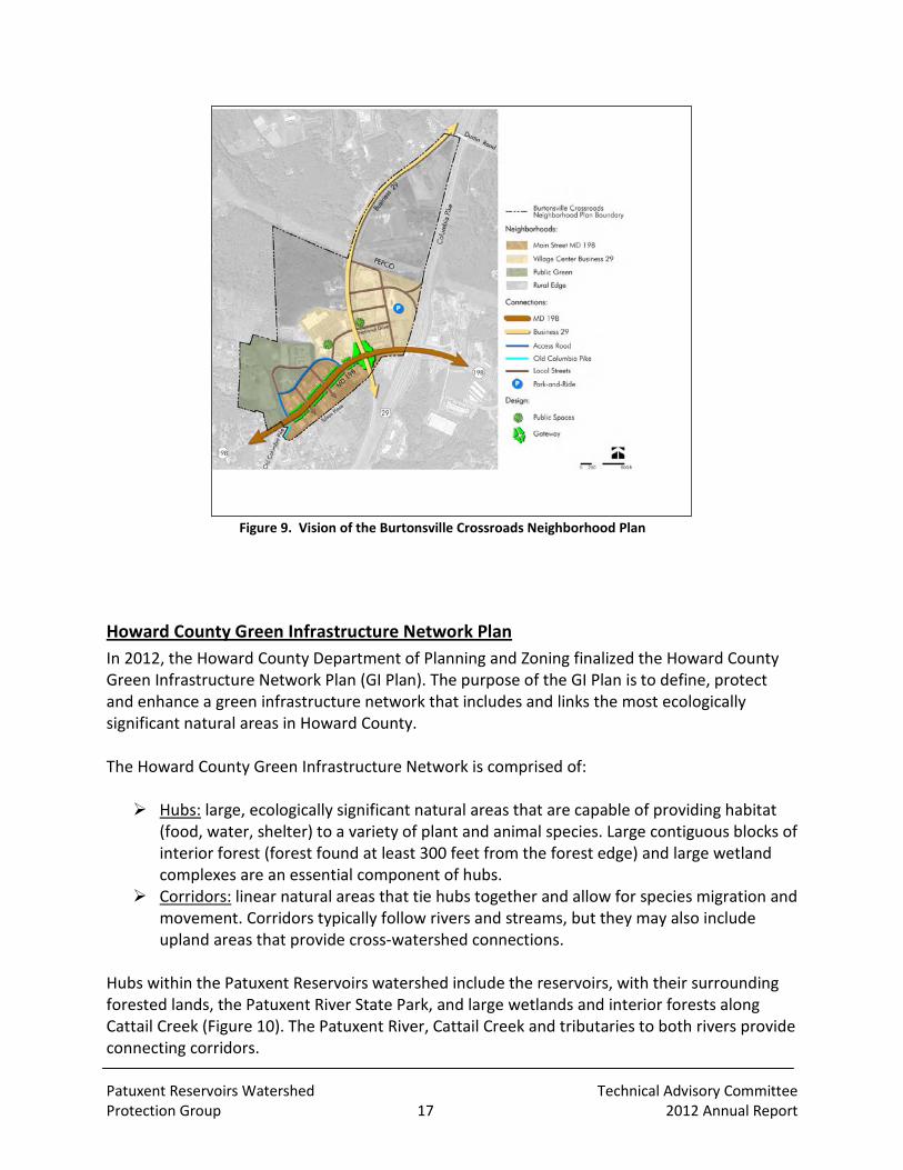
Burtonsville Crossroads Neighborhood Plan The Montgomery County Planning Board approved the draft Burtonsville Crossroads Neighborhood Plan on July 26, 2012. This plan is an amendment to the 1997 Fairlands Master Plan. The plan area consists of about 191 acres; it is located in the southern portion of the Patuxent Reservoirs Watershed focusing on the crossroads of US 29 and MD 198 (Figure 9). According to a transmittal letter from the Planning Board Chair to the County Executive, “The Plan establishes a vision to transform the existing crossroads into a complete community and provides recommendations for land use, transportation, environment and design that will enable the (US 29/MD 198) commercial crossroads area to thrive. This Plan focuses on improving the street network, adding an open space system, and providing for civic activities and recreational opportunities. The Plan also includes new residential opportunities in the core for a wide array of ages and incomes. The Plan also provides for the protection of the sensitive tributary headwaters of the Patuxent River. The recommendations, taken together, form a cohesive way forward and create a civic vision.” Access the plan online at: www.montgomeryplanning.org/community/burtonsville .
Patuxent Reservoirs Watershed Technical Advisory Committee Protection Group 17 2012 Annual Report
Figure 9. Vision of the Burtonsville Crossroads Neighborhood Plan
Howard County Green Infrastructure Network Plan In 2012, the Howard County Department of Planning and Zoning finalized the Howard County Green Infrastructure Network Plan (GI Plan). The purpose of the GI Plan is to define, protect and enhance a green infrastructure network that includes and links the most ecologically significant natural areas in Howard County. The Howard County Green Infrastructure Network is comprised of: Hubs: large, ecologically significant natural areas that are capable of providing habitat
(food, water, shelter) to a variety of plant and animal species. Large contiguous blocks of interior forest (forest found at least 300 feet from the forest edge) and large wetland complexes are an essential component of hubs.
Corridors: linear natural areas that tie hubs together and allow for species migration and movement. Corridors typically follow rivers and streams, but they may also include upland areas that provide cross-watershed connections.
Hubs within the Patuxent Reservoirs watershed include the reservoirs, with their surrounding forested lands, the Patuxent River State Park, and large wetlands and interior forests along Cattail Creek (Figure 10). The Patuxent River, Cattail Creek and tributaries to both rivers provide connecting corridors.

Patuxent Reservoirs Watershed Technical Advisory Committee Protection Group 18 2012 Annual Report
The GI Plan identifies tools to protect and enhance the network, including stewardship, financial incentives, regulatory protections, easements and acquisitions. Information on the Howard County Green Infrastructure Network Plan can be found on Green Central Station at: http://livegreenhoward.com/land/green-infrastructure/

Patuxent Reservoirs Watershed Technical Advisory Committee Protection Group 19 2012 Annual Report
Figure 10. Howard County Green Infrastructure Network

Patuxent Reservoirs Watershed Technical Advisory Committee Protection Group 20 2012 Annual Report
Agricultural Progress A summary of the progress made during the past year by both the Howard and Montgomery Soil Conservation Districts (SCDs) is provided in Table 4. The SCDs use funding from local, state and Federal programs to provide technical and financial assistance to landowners for the installation of BMPs. The numbers reported account for activity from July 1, 2011 through June 30, 2012. Table 4. Agricultural Progress for 2011-12 in the Patuxent Reservoirs Watershed
Howard SCD Montgomery SCD Conservation Plans developed (acres) 10 (1394.3) 21 (914)
Conservation Plans Revised (acres) 7 (408.2) - Landowners Applying BMPs 21 16
Educational/Outreach Events* 3 1 Best Management Practices Installed 101 130
Best Management Practice
Ag Waste Storage Structure - - Brush Management (acres) - 57.0
Cover Crop (acres) 1086.2 1192.0 Critical Area Planting (acres) - 0.3 Conservation Cover (acres) 3.0 3.9
Conservation Crop Rotation (acres) 214.7 830.0 Conservation Tillage (acres) - 426.0
Diversion (feet) - - Forest Stand Improvement (acres) - -
Forage Harvest Management - - Livestock Exclusion Fencing (feet) 1928.8 -
Grade Stabilization Structure (each) 2 - Grassed Waterways (acres) 1.6 1.55
Heavy Use Area Protection (acres) 1.5 - Lined Waterway or Outlet (feet) - 20.0
Livestock Watering System 4 4 Nutrient Management (acres) 1299.2 646.0
Pasture /Hayland Planting (acres) 7.0 1.8 Pest Management (acres) - 547.0
Pipeline (feet) - 300.0 Prescribed Grazing (acres) 76.0 7.4
Residue Management – Mulch Till (acres) - 53.3 Residue Management – No Till (acres) 888.3 13.6
Riparian Forested Buffer (acres) 0.7 - Roof Runoff System 2 -
Stream Crossing - - Spring Development - -
Waste Utilization (acres) 185.2 113.0

Patuxent Reservoirs Watershed Technical Advisory Committee Protection Group 21 2012 Annual Report
Patuxent Reservoirs Watershed Agricultural Cost-Share Program In 1998, the Patuxent Reservoirs Watershed Protection Group created the Patuxent Reservoir Protection Strategy Memorandum of Understanding, which established as its second initiative the Patuxent Reservoirs Watershed Agricultural Cost-Share Program. This cost-share program focuses on implementing BMPs that will benefit nearby stream systems. The program is targeted at small agricultural operations that may not qualify for other state and federal cost-share programs. In the Patuxent Reservoirs Watershed, many of these operations are small horse farms. The Howard Soil Conservation District (HSCD) completed a cost-share project for a small equine operation. Currently there are five horses but the owners are looking to expand their operation to a boarding operation for 10-15 horses as they construct a larger barn and implement rotational grazing. The completed cost-share agreement included the installation of 2,608 feet of stream fencing to reduce impacts from animals to the stream channel. The reimbursement for this project resulted in a $5,000 reduction of HSCD’s cost-share fund account. The Montgomery Soil Conservation District (MSCD) completed a cost-share project for a small equine operation and received an application for installing a BMP on another farm. The completed cost-share agreement included the installation of a grassed waterway and a heavy use area. The reimbursement for this project resulted in a $5,000 reduction of MSCD’s cost-share fund account. The remaining funds in this cost-share program as of June 30, 2012 are:
HSCD $752 MSCD $39,845 Total $40,597
During the December 2012 annual meeting of the PRWPG, the Policy Board approved a request by the HSCD for $50,000 to continue funding this cost-share program. The Policy Board approved the request with Howard County providing two-thirds ($33,333) of the funding and the WSSC providing the remaining one-third ($16,667). The funding from WSSC was contingent upon receiving a detailed accounting of past expenditures and a proposed budget for spending the requested $50,000.

Patuxent Reservoirs Watershed Technical Advisory Committee Protection Group 22 2012 Annual Report
Public Outreach Initiatives The TAC agencies and other groups in the watershed continued to coordinate public outreach and involvement initiatives during 2012. Under the coordination of WSSC Communications and Community Relations Office staff, there were several outreach activities in 2012 as well as other successful outreach events coordinated by other TAC agencies that occurred in Howard, Montgomery, and Prince George’s Counties. Approximately 2,000 people participated in these outreach initiatives.
Family Campfire The Annual Family Campfire event was held on Saturday, September 29, 2012 from 4:30-7:30 p.m. at WSSC’s Brighton Dam Recreation Area in Montgomery County. WSSC followed the successful format of the 2011 event, holding it on a Saturday, late afternoon to evening, and including a “Watershed Fair” of activities and displays of interest to children and their parents. These activities were followed by the traditional campfire with marshmallows and chocolate provided by WSSC. Approximately 20,000 flyers were distributed to schools, community centers and libraries, and a media release was sent out that was seen in several area newspapers. The “Watershed Fair” portion of the event included 20 activities and presentations where the children and their families could gain some understanding of where they live in relationship to the watershed and what they can do to help protect the watershed and the source water. A watershed map was used so that families could put a pin into where they live in or near the watershed. Other presentations included tours of Brighton Dam; a Litter Game; Watershed Jeopardy provided by Prince George’s County DER; EnviroScape provided by Howard County; environmental craft, recycling, and composting information provided by Montgomery County; a WSSC Lab presentation; hand washing activity; and wildlife and habitat display among others. All the children attending were encouraged to visit the displays with a Passport Sheet. When they answered the passport question at each display correctly they received a sticker on the passport. When the game sheet was filled they could turn it in for a bag of prizes provided by WSSC. More than 600 people attended this event. Mr. Jay Price, WSSC’s Production Team Chief, served as Master of Ceremonies, and Deborah Weller (DER) gave a welcome address on behalf of the Patuxent Reservoirs Watershed Protection Group. The campfire was managed by scouts from local Laurel Boy Scout Troop 1010. Music and refreshments were provided by the WSSC. The WSSC takes great pride in hosting this event and provides the staff for all preparations of the site as well as set up and clean up on the day of the event.
Patuxent Reservoirs Watershed Technical Advisory Committee Protection Group 23 2012 Annual Report
Izaak Walton League of America-Wildlife Achievement Chapter The Izaak Walton League of America-Wildlife Achievement Chapter (IWLA-WAC) in Damascus continued to sponsor outreach and involvement events for its members and the general public during 2012. These included: Spring and Fall watershed clean-ups working with the Maryland Department of Natural
Resources (DNR) and the Montgomery County Department of Public Works and Transportation (DPWT).
June and August Adopt-A-Road clean-ups with the DPWT. Free workshop in February for 'Make and Take' Rain Barrels. Two work days for deer exclusion and invasives maintenance for the Reddy Branch
reforestation, led by the M-NCPPC Planning. Two work days at Pigtail Branch, a tree planting site on WSSC property, to continue
invasives management and tree maintenance. Numerous work days on the Chapter's 120-acre property for invasives management and
native plantings. Hosted public meeting in June for WSSC’s buffer study.
In early 2012, the IWLA-WAC acquired an adjacent 23-acre parcel within the Agricultural Reserve. This parcel will be kept in an undeveloped state and is currently being leased to a local farmer for corn production.
Oaks Landfill Reforestation The Montgomery SCD received a $25,000 grant from Chesapeake Bay Trust (CBT) to reforest a section of the County-owned Oaks Landfill just south of Laytonsville. This area is located in the headwaters portion of the Hawlings River watershed. Although this is not a traditional agricultural BMP, the area is a large open field that is mowed periodically and sometimes cut for hay. The MSCD coordinated the project with Montgomery DEP, who owns the landfill site, and partnered with Montgomery County Public Schools to complete a large scale volunteer tree planting in April during Earth week. Several groups donated planting stock for the project, including the M-NCPPC, the DNR, and the PEPCO. Master Gardeners from the University of Maryland Extension program were enlisted to help supervise the volunteers. The initial planting of the landfill site occurred on Earth Day 2011 when about 100 volunteers planted 750 trees and shrubs. The goal of the project is to restore 10 acres of field to native forest, and to use the project as an educational tool to promote the important benefits forests provide for water and air quality, wildlife habitat, and beautifying our communities. The Oaks Landfill reforestation project continued in the fall of 2011 with a volunteer planting that involved over 60 students and teachers from Sherwood High School. TAC agency staff and Master Gardeners from the University of Maryland Extension program were on hand to assist the students with proper planting techniques and to provide a perspective on the benefits the trees will have for local habitat and Patuxent water quality. The volunteers planted and mulched almost 300 native trees and shrubs of various species. In the spring of 2012 several

Patuxent Reservoirs Watershed Technical Advisory Committee Protection Group 24 2012 Annual Report
hundred bare root seedlings were also planted to provide an opportunity for comparing survival and growth rates between the larger potted trees and seedlings.
Patuxent River Clean-up In cooperation with the office of the Patuxent Riverkeeper, WSSC Communications and Community Relations Office participated again in the annual Patuxent River Clean-up. On the designated clean up day, March 31, 2012, approximately 70 volunteers from the neighboring communities, church groups, and Boy and Girl Scout troops formed crews at nine WSSC recreation areas, and collected hundreds of pounds of trash and recyclables. As in the past, some sites were cleaned on other weekends in April and quantities collected were included in the final tallies reported by the Riverkeeper. Site leaders for this effort volunteered their time to organize, recruit, and report for the Clean-up event.
RainScapes Rewards Program The Montgomery County Department of Environmental Protection (DEP) continued its countywide RainScapes Rewards Program to provide rebates to property owners who voluntarily install practices that capture and store runoff from rooftops and paved areas in their yards, thus reducing storm water impacts downstream. Since FY08, there have been a total of 40 projects installed in the Patuxent Reservoirs Watershed. The majority of these projects were urban tree canopy plantings. Combined savings are possible for these projects using $25 coupons from both the Maryland Department of Natural Resources and the M-NCPPC, and the RainScapes $150 per tree rebate. Rainwater harvesting practices using rain barrels or cisterns are the second most popular practices for the rebate program. No rain gardens have been installed in the Reservoirs Watershed through the RainScapes Rewards program. During FY12, there were 4 projects installed in the Patuxent Reservoirs Watershed. There were two tree canopy and two rain barrel rebates, with six trees total and 315 gallons in rain barrels. Applicants spent $2,061 and received $1,500 in rebates.
Soil Conservation District Agriculture Outreach Efforts Both the HSCD and the MSCD continued to help sponsor a Pasture Management Workshop and pasture walks for horse owners at the University of Maryland – Central Maryland Research and Education Center (CMREC) farm in Clarksville. Although this location is in the Middle Patuxent Watershed, it included attendees from the Patuxent Reservoirs Watershed and surrounding areas. The HSCD sponsored the Mid-Winter Agricultural Meeting that educated approximately 50 attendees concerning farm diversification to include the next generation, the Bay TMDL and nutrient trading.

Patuxent Reservoirs Watershed Technical Advisory Committee Protection Group 25 2012 Annual Report
The MSCD collaborated with University of Maryland Extension to host two Equine Management Seminars and a Spring Pasture Walk. These programs provided information on pasture renovation, weed identification, forage sampling/quality, the equine digestive system, and other topics to about 55 participants. The target audience for these programs is owners/operators of small equestrian operations. Helping this sector of the agricultural community to better manage their resources will result in improved water quality and other environmental benefits.
Water Festival Approximately 500 4th graders participated in WSSC’s 6th Annual Children’s Water Festival on May 9 and 10, 2012 at Brighton Dam. The students who attended were from Broad Acres Elementary School in Silver Spring; Garrett Park Elementary School in Bethesda; Capitol Heights and Carmody Hills Elementary Schools in Capitol Heights; Gladys Noon Spellman Elementary School in Cheverly; and Princeton Elementary School in Suitland. Presenters from the Montgomery County DEP, the Prince George’s County DER, and other agencies helped to create 13 hands-on activities for the students to learn about the Patuxent River and the Chesapeake Bay.
WSSC-Owned Land Activities The WSSC owns and manages about 5,600 acres that surround both of the Patuxent Reservoirs. The WSSC coordinated 30 environmental stewardship opportunities with over 700 people participating from environmental groups, community colleges and high schools. The activities ranged from collecting trash to removing invasive weeds, planting trees and perennials, to clearing debris from culverts along the property perimeter access roads. The activities centered around Scott’s Cove, Pig Tail, Supplee, Brown’s Bridge and Triadelphia recreation areas. The WSSC created partnerships with St. Vincent Pallotti High School, IWLA-WAC, Our Lady of Good Counsel High School, Sherwood High School, Howard Community College, Montgomery Community College, Trail Riders of Today, University of Maryland, and consultants Brown and Caldwell and CH2M Hill. The clean-ups and tree plantings allowed WSSC to not only help the watershed around Triadelphia and Rocky Gorge reservoirs, but to also strengthen ties with the community and the community’s future leaders (middle school, high school and college students). This year was the first year that the WSSC worked with volunteers to clean out culverts along the perimeter access road at Scott’s Cove. Using volunteers, WSSC led the efforts to clean out the culverts to stop stormwater from eroding a road. The WSSC also worked with a group of neighbors who requested trees in an area that had been overrun by invasive species such as kudzu, bittersweet and mile-a-minute. The WSSC worked to get 28 trees donated and then recruited volunteers to help the neighbors plant the trees. The neighbors have agreed to water and care for the trees for the first three years.

Patuxent Reservoirs Watershed Technical Advisory Committee Protection Group 26 2012 Annual Report
The WSSC also held its third, annual Warbler Day at Pig Tail Recreation Area on May 5, 2012. Sixteen people attended in conjunction with the Howard and Montgomery County Bird Clubs. Fifty-two different species of birds were spotted. In the afternoon of the same day, the WSSC, in conjunction with the Maryland Native Plant Society, conducted a Tree Tour with seven attendees at the Greenbridge Recreation Area.

27
Table 5. Performance Measures and Goals for Priority Resources PRIORITY RESOURCES: GOALS & PERFORMANCE MEASURES
Resource: Reservoir/Water Supply Issue: The public need for a sufficient quantity of safe and high quality drinking water calls for adopting a proactive and multi-barrier approach, which starts with utilizing raw water of the highest quality and sustainable quantity, now and in the future. To achieve this for the Patuxent water filtration plant, we need to control reservoir eutrophication, reduce disinfectant by-products precursors, and limit reservoirs capacity loss.
Measures Goals Implementation Items Time Line Responsible Partner
Chlorophyll-a (CHL-a)
• CHL-a not to exceed a 10 µg/L mean during the growing season and not to exceed a 30 µg/L instantaneous concentration
• Perform reservoir monitoring for CHL-a, DO, and total organic carbon (TOC) during the growing season
Ongoing
WSSC
Dissolved oxygen (DO)
• DO not to fall below 5 mg/L at any time in the epilimnion, not to fall below 5 mg/L in the entire water column during completely mixed periods, and not to fall below 10% saturation at any time in the hypolimnion
• Perform reservoir monitoring for CHL-a, DO, and TOC during the growing season
Ongoing WSSC
Suite of water quality parameters in reservoir monitoring protocol
• Five-year data trend analysis for other monitored water quality parameters shows no net deterioration
• Enhance and fine tune model reliability for watershed management
• Develop and begin implementation of a plan to reduce nutrients, based on model/TMDL requirements
• Update trend analysis for reservoir water quality parameters on a 5-year cycle
TMDL submitted to EPA for Approval
Next Update: 2014
WSSC/MDE
TAC
WSSC
Total organic carbon
• TOC – 20% annual reduction goal, with 40% reduction for peak quarter at the location where water is withdrawn for treatment purposes
• Perform reservoir monitoring for CHL-a, DO, and TOC during the growing season
Ongoing WSSC
Sediment • Sediment accumulation rate not to
exceed previous years • Perform bathymetric survey of reservoirs
at 10 year intervals or less Completed FY07 WSSC

28
PRIORITY RESOURCES: GOALS & PERFORMANCE MEASURES (continued) Resource: Terrestrial Habitat Issue: Preservation of forests provides water quality benefits by reducing sediment and nutrient loading of streams from surrounding land uses.
Measures Goals Implementation Items Time Line Responsible Partner
Forest Cover
• Maintain and increase forest cover
• Increase forest interior habitat
• Encourage private property owners to participate in tree planting programs
• Ensure publicly owned parkland and open space is forested to the maximum extent possible
Ongoing
2006 – 2023
TAC
TAC
Forest Connectivity • Improve forest connectivity (larger forest tracts are connected by forest corridors)
• Target reforestation and forest conservation programs to increase forest connectivity and forest interior habitat
Ongoing TAC
Forest Size • Increase forest size • Encourage private property owners to participate in tree planting programs
• Ensure publicly owned parkland and open space is forested to the maximum extent possible
Ongoing
2006 – 2023
TAC
TAC
Forest Diversity • Ensure diverse forest communities (communities contain a variety of species and ages)
• Develop a forest management plan to ensure forest diversity and long-term natural regeneration, identifying and addressing potential problems such as excessive deer populations, invasive species and human impacts
2006 – 2013
Plan completed FY08
TAC
Forest Sustainability • Ensure forests are self-sustaining and capable of long-term natural regeneration
• Implement deer management programs • Implement strategies for control of
invasive plants
Ongoing
Ongoing
TAC
TAC

29
PRIORITY RESOURCES: GOALS & PERFORMANCE MEASURES (continued) Resource: Stream System Issue: Preventing stream habitat degradation - The stream system includes all intermittent and perennial streams and their adjacent floodplains. A stable stream system provides significant nutrient and sediment removal during both baseflow and storm flow events. The stream and its associated riparian buffer are also important as sources of high quality food and habitat for both aquatic and terrestrial organisms.
Measures Goals Implementation Items Time Line Responsible Partner
Buffer corridor width and continuity
• A minimum 35-foot riparian buffer on all streams on properties that were developed prior to current stream buffer requirements
• Establish and maintain minimum 35-foot riparian buffers on all publicly-owned land
• Accelerate programs to establish and maintain streamside buffers to a minimum of 35 feet on privately-owned lands to the maximum extent possible
2006 – 2013
2006 – 2023
WSSC, M-NCPPC, HC, MC WSSC, M-NCPPC, HC, HSCD, MC, MSCD
Stream bank and stream channel stability
• No areas of "severe" or "very severe" stream bank erosion based on the Stream Corridor Assessments and other locally collected data.
• Establish and maintain streamside fencing programs to keep all livestock out of streams to the maximum extent possible
• Address significant areas of stream bank and channel instability through stream restoration projects and storm water retrofits to the maximum extent possible
2006 – 2013
2006 – 2013
HSCD, MSCD HC, HSCD, M-NCPPC, MC

30
PRIORITY RESOURCES: GOALS & PERFORMANCE MEASURES (continued) Resource: Aquatic Biota Issue: Biological Integrity– This is the condition of the benthic macroinvertebrate communities based on a comparison to a reference stream in Montgomery County. A reference stream is relatively undisturbed and therefore the best quality to be expected in the region that includes the Patuxent Reservoirs Watershed.
Measures GoalS Implementation Items Time Line Responsible Partner
IBI - Index of Biological Integrity
• No subwatershed with a benthic IBI indicating "fair" or "poor" condition
• Aggressively pursue cost-share funds to construct agricultural BMPs, stream restoration, and storm water retrofit projects to address factors contributing to degraded biological integrity
• Mitigate runoff impacts from land use changes
2006 – 2023
2006 – 2023
HC, HSCD, MC, MSCD, M-NCPPC HC, MC, M-NCPPC
• Preserve conditions in subwatersheds with "excellent" and "good" benthic IBIs
• Protect existing habitat and water quality of streams in high-quality subwatersheds to the maximum extent possible by pursuing programs to maintain or increase existing land cover
2006 – 2023
HC, HSCD, MC, MSCD, M-NCPPC
IBI - Index of Biological Integrity is also referred to as Index of Biotic Integrity in Maryland Biological Stream Survey publications.

31
PRIORITY RESOURCES: GOALS & PERFORMANCE MEASURES (continued) Resources: Rural Character and Landscape Issue: Preserving open spaces and maintaining an economically viable and environmentally protective agricultural community.
Measures Goals Implementation Items Time Line Responsible Partner
Agricultural Preservation Enrollment • Total acres enrolled • Number of farms enrolled
• Preserve the agricultural and rural nature, and open space of the watershed
• Continue easement acquisition through agricultural land preservation programs
• Continue agricultural economic development programs
Ongoing
Ongoing
HC, MC
HC, MC
Agricultural Demographics • Acres of agricultural land • Market value of agricultural
production • Size of farms • Types of farms
• Preserve the agricultural and rural nature, and open space of the watershed
• Continue zoning and land use policies in the watershed to maintain rural character
• Continue agricultural economic
development programs
Ongoing
Ongoing
HC, M-NCPPC
HC, MC
Open Space and Parkland Acquisition and Easement Programs • Acres of open space land
preserved by non-agricultural easements or acquisition
• Create a landscape that is protective of water quality
• Utilize effective open space land management practices that are beneficial to water quality
Ongoing HC, M-NCPPC, WSSC
Participation in agricultural conservation programs and percent of conservation plans that are implemented
• Create a landscape that is protective of water quality
• Encourage participation in other conservation and open space preservation programs
• Encourage enrollment in federal and state nutrient management and stream protection programs
• Promote greater utilization of funding provided by the Reservoir Protection Group to supplement federal and state agricultural programs
• Create and routinely update an electronic map based system to track BMP implementation
Ongoing
Ongoing
Ongoing
2006 – 2013
HC, MC, M-NCPPC
HSCD, MSCD
HSCD, MSCD
HSCD, MSCD
32
PRIORITY RESOURCES: GOALS & PERFORMANCE MEASURES (continued)
Resource: Public Awareness and Stewardship Issue: Awareness and support by residents and resource users
Measure Goals Implementation Items Time Line Responsible Partner
Residents participating in stewardship activities
• Citizen action to improve watershed resources – see evidence of watershed friendly activities and practices
• 10 to 15 stewardship offerings
per year
• Identify citizen groups throughout watershed and be available for presentations upon request
• Organize stewardship events and participate in other community events
• Recognize good stewards through annual awards
• Form “Friends of the Watershed” group of citizen volunteers that will take on tasks such as newsletter preparation and some Earth Month planning
2006 – 2009
Ongoing
2006 – 2008
2006 – 2009
TAC
TAC
MC, PGC, HC, M-NCPPC
TAC
Schools participating in mentoring
• School and community involvement – 20 participating Green School partners by end of 2003 and 5 additional schools participating each year thereafter until all 43 are attained
• Continue and expand Green Schools Mentoring Partnership
Ongoing WSSC, HC, MC, PGC, M-NCPPC
Active support by elected officials
• Routine communication with elected officials
• Routine communication with elected officials
Ongoing
TAC
Routine coverage by media
• Expanded media coverage of watershed events – print, radio and TV
• Increase communication with media
• Support regional efforts to establish media-savvy campaigns that emphasize water quality protection
2006 – 2009
2006 – 2008
TAC

33
Table 6. Work Plan Expenditures for Current Fiscal Year
PATUXENT RESERVOIRS WATERSHED WORK PROGRAM FOR FY13
PRIORITY RESOURCES
PROTECTED
IMPLEMENTATION
NEED
IMPLEMENTATION ITEM
AGENCY
FY 2013
Reservoir/Water Supply
Reservoir and tributary water chemistry and flow monitoring
Reservoir monitoring and lab analysis WSSC $162,000 (in-kind)
5 US Geological Survey stream flow gauging stations
WSSC
$60,000
5 year Trends Analysis (next due c. FY 2013) WSSC $0
Stream System Aquatic Biota
Tributary biological and habitat monitoring
Biomonitoring in Cattail Creek and Upper and Lower Brighton Dam
HC $40,000
Upper Patuxent and Hawlings River MC $0
Hawlings River Restoration Monitoring MC $0
Reservoir/Water Supply Stream System Aquatic Biota
Stream corridor management
Patuxent Restoration Project Inventory MC *$320,000
Reddy Branch Project Implementation M-NCPPC $35,000
Rachel Carson Park Project Implementation M-NCPPC $55,000 $ 5,000 (in-
kind)
* Funding moved from FY12 to FY13 for task order contract

34
PATUXENT RESERVOIRS WATERSHED WORK PROGRAM FOR FY13
PRIORITY RESOURCES
PROTECTED
IMPLEMENTATION
NEED
IMPLEMENTATION ITEM
AGENCY
FY 2013
ALL Priority Resources Management of
agricultural cost-share initiatives
Program oversight for voluntary implementation of agricultural BMPs through existing local, State of Maryland, and Federal programs
HSCD, MSCD
$80,000 (HSCD in-kind)
ALL Priority Resources Public outreach and involvement initiatives
RainScapes Rewards MC Rebates availa-ble to county residents for Low Impact Develop-ment (LID)
ALL Priority Resources Public outreach and involvement initiatives
Earth Month, and other outreach activities WSSC
Other TAC agencies
$140,000 (in-kind)
$2,500
(in-kind)
ALL Priority Resources Complete Annual Report and Technical Supplement
Compilation and editing WSSC
Other TAC Agencies
$10,000
In-kind
Coordination and Collaboration
Provide administrative support & coordination among partners
WSSC $35,000

35
PATUXENT RESERVOIRS WATERSHED WORK PROGRAM FOR FY13
PRIORITY RESOURCES PROTECTED
IMPLEMENTATION
NEED
IMPLEMENTATION ITEM
AGENCY
FY 2013
Reservoir/Water Supply Terrestrial Habitat Stream System Aquatic Biota Public Awareness & Stewardship
Assessment of potential watershed protection & restoration opportunities
Watershed restoration planning effort in Prince George’s County portion of the Rocky Gorge Reservoir Watershed
PGC $2,000 (in-kind)
Reservoir/Water Supply Terrestrial Habitat
Independent evaluation of WSSC’s buffer property
Assessment of current conditions and potential enhancements of WSSC’s water supply protection buffer property
WSSC $225,000
Reservoir/Water Supply Stream System Aquatic Biota Public Awareness & Stewardship
TMDL Implementation Develop the point source part of the TMDL Implementation Plan for Howard County portion of the watershed. (includes large lot residential development)
HC $40,000
Develop the point source part of TMDL Implementation Plan for Montgomery County portion of the watershed. (does not include large-lot residential development)
MC * $0
TOTAL FUNDING $1,211,500 * Accepted by MDE in August 2011. DEP completed refining a plan in February 2011 for the Patuxent Reservoirs Watershed through a Task Order contract which included a
stream corridor project inventory

![Hydrologic moment of a watershed area - …Geomorphological Unit Hydrograph [9-10] conceptualizes the watershed as a cascade of linear storage reservoirs with two variants: one in](https://static.fdocuments.net/doc/165x107/5f03396c7e708231d40826b9/hydrologic-moment-of-a-watershed-area-geomorphological-unit-hydrograph-9-10.jpg)