Patterns Of City Making - ijser.org · PDF filePatterns Of City Making ... imageabilty,...
13
Patterns Of City Making H Nivedita Varma, Department of Architecture College of Engineering, Trivandrun Email: [email protected] Abstract - What is a city? A city is not the outcome of a single person’s decision nor is it a simplified version of an optimum transportation network. It is a complex system with many interacting sub-units on many different levels of scale, each working out within itself a ‘self-sufficient’ module connected with the whole with various networks that instead of isolating the sub-units reinforce the functional ‘wholeness’ of each. (Christopher Alexander, Nature of order) Complex large scale wholes can only work as an outcome of tightly interacting sub-units. In a city made of geometric modules simplified to bring about ‘crisp’ and ‘coherent’ plans, the depth of small scale interactions between the sub-units and many cases the presence of such varied scale of units in itself is lost in the Gaussian understanding of contemporary urbanism. The paper explains how a city evolved from its historic antecedent has much more interlinked patterns within its complexity that contributes to the cities ‘liveability’ and ‘imageabilty’ rather than the simplistic isolated patterns within a planned city. Keywords- City, patterns, imageabilty, complexity, urban coherence, liveability, Ahmedabad, Gandhinagar, Wholeness. I. INTRODUCTION “The city is a living thing, pulsing with vital forces, growing relentlessly along natural paths.” Consider the city of today, a city where the dynamics of life are put into acceleration simultaneously with the peaceful breaks of a peaceful summer evening. It is the stage upon which the drama of the collective ‘human condition’ plays out, fruitfully and lavishly each actor fulfills his parts, would it not be a shame is the stage instead of nurturing the individual curbs his choice of acting. “All the world is a stage and all the men and women merely players”- Shakespeare Cities a larger scale of human settlements evolve Dr Priyanjali Prabhakar Department of Architecture College of Engineering, Trivandrum out of a complex play of economic, political, social and cultural factors. Through history- the ancient civilizations were also based upon strong city centers that had either religious or administrative cores for *‘symbolic approach rather than pragmatic logic’where religious architecture was held central, to pre- industrial cities of Europe where the dual nature of the society i.e the elite and the lower class, played a huge role in the city’s spatial organization and where hierarchy reigned, and the socialist city where all such social scales dispersed to create a society based on a different set of economic classes. As time progresses each stage of evolution shows complete dissolution of its geographic and contextual past, a future stranded on its own isolated in its originality and cannot function as a ‘liveable’ city. Many such modern blunders such as Chandigarh designed by Le Corbusier and Brasilia designed by Oscar Neymeyer are clear examples of why and how a city fails. II. LITERATURE REVIEW The study identifies from its literature background 3 characteristics that can be analysed from within the patterns of an urban space. They are: Imageabilty based on scale hierarchy The connective geometry of urban interfaces- Complexity Wholeness in its lower scale sub-units. Imageabilty- Kevin Lynch proposed a theory of the image of the city. The imageabilty or the inherent legibility of a city depends on the clarity of its organisation, a clear distinct composition of elements including -Districts, edges, nodes, paths and landmarks. These elements through properties of - identity, structure and meaning lend to the urban fabric an image that remains in the minds of the International Journal of Scientific & Engineering Research, Volume 5, Issue 7, July-2014 ISSN 2229-5518 146 IJSER © 2015 http://www.ijser.org IJSER
-
Upload
trinhtuong -
Category
Documents
-
view
218 -
download
1
Transcript of Patterns Of City Making - ijser.org · PDF filePatterns Of City Making ... imageabilty,...

Patterns Of City Making
H Nivedita Varma, Department of Architecture
College of Engineering, Trivandrun Email: [email protected]
Abstract - What is a city? A city is not the outcome of a single person’s decision nor is it a simplified version of an optimum transportation network. It is a complex system with many interacting sub-units on many different levels of scale, each working out within itself a ‘self-sufficient’ module connected with the whole with various networks that instead of isolating the sub-units reinforce the functional ‘wholeness’ of each. (Christopher Alexander, Nature of order) Complex large scale wholes can only work as an outcome of tightly interacting sub-units. In a city made of geometric modules simplified to bring about ‘crisp’ and ‘coherent’ plans, the depth of small scale interactions between the sub-units and many cases the presence of such varied scale of units in itself is lost in the Gaussian understanding of contemporary urbanism. The paper explains how a city evolved from its historic antecedent has much more interlinked patterns within its complexity that contributes to the cities ‘liveability’ and ‘imageabilty’ rather than the simplistic isolated patterns within a planned city.
Keywords- City, patterns, imageabilty, complexity, urban coherence, liveability, Ahmedabad, Gandhinagar, Wholeness.
I. INTRODUCTION
“The city is a living thing, pulsing with vital forces, growing relentlessly along natural paths.”
Consider the city of today, a city where the dynamics of life are put into acceleration simultaneously with the peaceful breaks of a peaceful summer evening. It is the stage upon which the drama of the collective ‘human condition’ plays out, fruitfully and lavishly each actor fulfills his parts, would it not be a shame is the stage instead of nurturing the individual curbs his choice of acting.
“All the world is a stage and all the men and women merely players”- Shakespeare
Cities a larger scale of human settlements evolve
Dr Priyanjali Prabhakar Department of Architecture
College of Engineering, Trivandrum
out of a complex play of economic, political, social and cultural factors. Through history- the ancient civilizations were also based upon strong city centers that had either religious or administrative cores for *‘symbolic approach rather than pragmatic logic’where religious architecture was held central, to pre- industrial cities of Europe where the dual nature of the society i.e the elite and the lower class, played a huge role in the city’s spatial organization and where hierarchy reigned, and the socialist city where all such social scales dispersed to create a society based on a different set of economic classes.
As time progresses each stage of evolution shows complete dissolution of its geographic and contextual past, a future stranded on its own isolated in its originality and cannot function as a ‘liveable’ city. Many such modern blunders such as Chandigarh designed by Le Corbusier and Brasilia designed by Oscar Neymeyer are clear examples of why and how a city fails.
II. LITERATURE REVIEW
The study identifies from its literature background 3 characteristics that can be analysed from within the patterns of an urban space. They are:
Imageabilty based on scale hierarchy The connective geometry of urbaninterfaces- Complexity Wholeness in its lower scale sub-units.
Imageabilty- Kevin Lynch proposed a theory of the image of the city. The imageabilty or the inherent legibility of a city depends on the clarity of its organisation, a clear distinct composition of elements including -Districts, edges, nodes, paths and landmarks. These elements through properties of - identity, structure and meaning lend to the urban fabric an image that remains in the minds of the
International Journal of Scientific & Engineering Research, Volume 5, Issue 7, July-2014 ISSN 2229-5518 146
IJSER © 2015 http://www.ijser.org
IJSER

users. This property of ‘being easily recalled to memory’ is the basis of Kevin Lynch’s imageabilty. A quantitative way of analysing a city fabric, this time replacing the term elements with city artifacts (Ben Jiang, Computing the image of the city) such as streets, buildings, city cores etc. Each artifact can be an amalgam of many layers of different hierarchy of scales. Further all these different scales should be related and must work together to form a coherent whole. These notions form the basis of Nikos Salinger’s structural order.
According to Salingaros a city is said to be dead or boring if the city violates the multiplicity rule. (the hierarchy scale) Euclidean geometric thinking is likely to produce a boring structure. A dead structure essentially lacks the hierarchy of scales or misses some levels of scale: either the smallest the largest or the intermediate ones. Further both Salingaros and Alexander emphasises that the rules of scale underlie all the natural, physical, biological and social systems existing. Without levels of hierarchy a city would have layers with uniform distributions (extremes of order and disorder) with little or no variance creating a Gaussian pattern thus creating un-imageable or illegible spaces.
Complexity- The connective geometry of urban interfaces.(Salingaros, 2000) In a living city, boundaries define and connect different regions, and encourage many human processes that make the city successful. Whether these functions take place is largely a consequence of the geometry of the urban boundaries –usually termed as fractal patterns. Pattern groups for different results should be separate, and not confuse each other's clarity. In the case of urban interfaces, several patterns are directly relevant. The following aspects that create a relevant pattern analysis has been chosen (Alexander, Ishikawa et al., 1977).
Wholeness- Christopher Alexander explains in his book (THE NATURE OF ORDER) 15 aspects that can aid the manifestation of life and ‘wholeness’ to a place. These fifteen aspects pertain to the geometry of a place and tend to overlap yet creating helpful and interesting and valid mans of comparing cities that are in his terms ‘alive’ or ‘dead’.
Rule 1. COUPLINGS: Strongly-coupled elements on the same scale form a module. There should be no unconnected elements inside a module.
Rule 2. DIVERSITY: Similar elements do not couple. A critical diversity of different elements is needed because some will catalyze couplings between others.
Rule 3. BOUNDARIES: Different modules couple via their boundary elements. Connections form between modules, and not between their internal elements.
Rule 4. FORCES: Interactions are naturally strongest on the smallest scale, and weakest on the largest scale. Reversing them generates pathologies.
Rule 5. ORGANIZATION: Long-range forces create the large scale from well-defined structure on the smaller scales. Alignment does not establish, but can destroy short-range couplings.
Rule 6. HIERARCHY: A system's components assemble progressively from small to large. This process generates linked units defined on many distinct scales.Rule 7. INTERDEPENDENCE: Element s and modules on different scales do not depend on each other in a symmetric manner: a higher scale requires all lower scales, but not vice versa.
Rule 8. DECOMPOSITION: A coherent system cannot be completely decomposed into constituent parts. There exist many inequivalent decompositions based on different types of units.
The basic essence to urban coherence is through forces termed after the physical force of ‘coupling’. This is an important aspect explained in detail by Salingaros as to how urban modules interact at its edges.
III. CASE STUDY
As the sole inspiration for the initiation of this research topic came from the contrast that was felt between the two cities of Ahmedabad and Gandhinagar, the case studies taken into account to study the pattern differences between a planned and a organically evolved city are the same. Placed within a similar context, both along the sides of the river Sabarmati, at just a distance of 23 km, the choice is relevant as most other variables are deleted, giving way for an authentic pattern analysis of the two cities.
International Journal of Scientific & Engineering Research, Volume 5, Issue 7, July-2014 ISSN 2229-5518 147
IJSER © 2015 http://www.ijser.org
IJSER
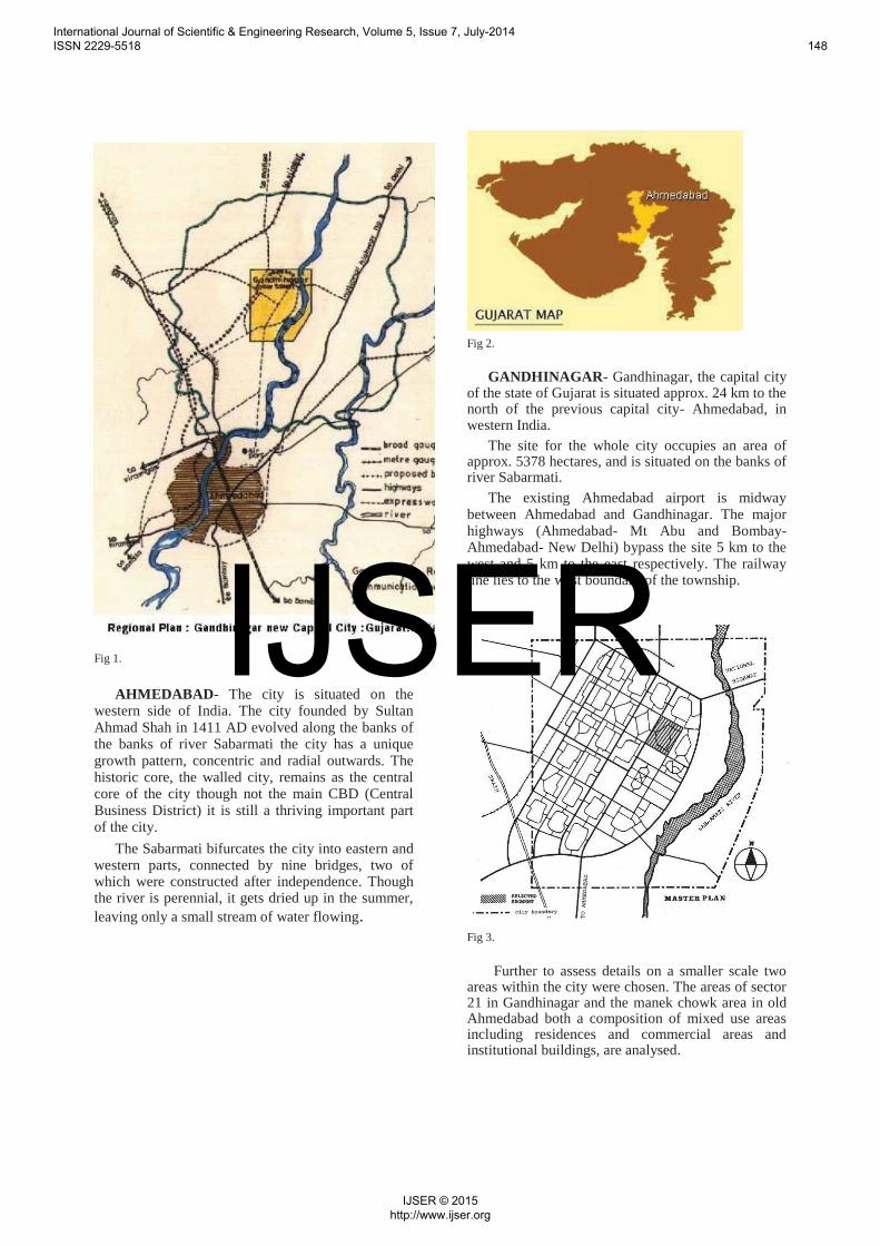
Fig 1.
AHMEDABAD- The city is situated on the western side of India. The city founded by Sultan Ahmad Shah in 1411 AD evolved along the banks of the banks of river Sabarmati the city has a unique growth pattern, concentric and radial outwards. The historic core, the walled city, remains as the central core of the city though not the main CBD (Central Business District) it is still a thriving important part of the city.
The Sabarmati bifurcates the city into eastern and western parts, connected by nine bridges, two of which were constructed after independence. Though the river is perennial, it gets dried up in the summer, leaving only a small stream of water flowing.
Fig 2.
GANDHINAGAR- Gandhinagar, the capital city of the state of Gujarat is situated approx. 24 km to the north of the previous capital city- Ahmedabad, in western India.
The site for the whole city occupies an area of approx. 5378 hectares, and is situated on the banks of river Sabarmati.
The existing Ahmedabad airport is midway between Ahmedabad and Gandhinagar. The major highways (Ahmedabad- Mt Abu and Bombay- Ahmedabad- New Delhi) bypass the site 5 km to the west and 5 km to the east respectively. The railway line lies to the west boundary of the township.
Fig 3.
Further to assess details on a smaller scale two areas within the city were chosen. The areas of sector 21 in Gandhinagar and the manek chowk area in old Ahmedabad both a composition of mixed use areas including residences and commercial areas and institutional buildings, are analysed.
International Journal of Scientific & Engineering Research, Volume 5, Issue 7, July-2014 ISSN 2229-5518 148
IJSER © 2015 http://www.ijser.org
IJSER

LIFE IN AHMEDABAD Ahmedabad is a bustling city that combines
various strata of society into a working whole, starting from the bustling slum-like yet highly lively streets of Gulbaidighra, on the way to Cept from Paldi, where the people work day and night to sculpt beautiful statues of Lord Ganesh, to the high level societies working at various businesses at Navrangpura, Ahmedabad forms an amalgam of various levels of society integrated into a sequential and hierarchical whole.
The slum houses close to 7,000 dwellers who are mostly Rajasthani Marwadis and Northern Gujaratis. They work as sculptors before festivals like Ganesh Chaturthi and Navaratri. During the rest of the year, they survive by taking up odd jobs and working as domestic help in the community.
A. Gulbai Tekra district
Fig 5.
Middle class commercial stretch along Navrangpura road
Commercial and economic nodes interspersed to give rise to a well-connected, self-sufficient integration of modules
Each module connected via roads acts as a unique activity generator with points that are ‘alive’ either simultaneously or at intervals with each other keeping the place active throughout.
Fig 4.
International Journal of Scientific & Engineering Research, Volume 5, Issue 7, July-2014 ISSN 2229-5518 149
IJSER © 2015 http://www.ijser.org
IJSER

Fig 6. Activity cores and spill over, Navrangpura area, Ahmedabad
Each point marks a centre of activity-- institutions, markets, sports centre, community centre, street markets, retail shops, commercial outlets etc.
The entire city even at its most micro level exhibits this varied act
Thus a conducive whole, through coherent patterns (as will be analysed later in this paper) the entirety of Ahmedabad acts and works as a whole, a hidden system beneath all its chaos.
GANDHINAGAR Gandhinagar, the capital city of the state of
Gujarat is situated approx. 24 km to the north of the previous capital city- Ahmedabad, in western India.
The city was planned and implemented between 1965-1970 by two Indian planners, H.K.Mewada and P.M.Apte, and an influential group of architects from Ahmedabad with active support from some industrialists.
Planned as the administrative capital of the state, the current and future population employed in state government offices was distributed in 30 residential sectors around the State Assembly-Secretariat complex. Each residential sector could accommodate about 50% of population, and was intended to house the half of the population employed
by the government. Plots on the periphery of each sector are meant for private and supporting population that constitutes the remaining 50%.
Fig 7. Activity cores and spill over, sector 21 Gandhinagar
“LIFE-LESSNESS” IN GANDHINAGAR
Even though the planners had thought of social integration, the elaborate distinction in the occupancies of each sector, they did not provide with enough incentives for people of all classes to settle here. Thus the houses occupied by the purely ‘administrative’ sector remains exaggerated in scale yet isolated and empty in existence.
Fig 8.
International Journal of Scientific & Engineering Research, Volume 5, Issue 7, July-2014 ISSN 2229-5518 150
IJSER © 2015 http://www.ijser.org
IJSER

The Central vista though immaculate in its organization remains un-used and isolated.
WHERE AN HOW THE PLANNING FAILS
The rigidity of the ‘sector’ patterns restrict further growth. It is impossible to limit the growth potential of any city to any one direction, one can only guide it. Any action strictly curbed will over time change its needs and in all possibility reject the pattern dictated. This is what is happening in Gandhinagar.
Fig 9. The initial growth pattern of Gandhinagar was to
be to the west, the lines concurrent and extensions of the present sectors. But now proposals show a development plan to the south of Gandhinagar, linking it via commercial routes. The planners seem to mesh Gandhinagar into Ahmedabad. The identity of the new capital city now lies as a suburb of Ahmedabad.
How would you assess a city of its qualities that make it apparently alive or ‘dead’ spaces? From background researches 3 different aspects of urban ‘liveability’ and ‘imageability’ has been assessed.
IV. METHODOLOGY
Two different methods in different scales have been used to analyse the 2 cities based on its imageabilty, complexity and wholeness.
Hierarchy and imageabilty- A quantitative way of analysing a city fabric’s imageabilty or memorability, this time replacing the term elements with city artifacts (Ben Jiang, Computing the image of the city) such as streets
lengths, buildings, city cores etc. Here the street length hierarchy is chosen and maps are plotted to show. A more diverse hierarchy implies better imageabilty.
Connectivity- The various networks connecting the city limits are the major part of any city. The more the no. of connections into a limited no. of major arteries of a city the more legible the city becomes.
Urban coherence- An essential quality shared by all living cities is a high degree of organized complexity (Jacobs, 1961). the resonance with human beings that characterizes great urban environments could be explainable in terms of geometry.
V. ANALYSIS A. Hierarchy- The maps plotting the hierarchical variances of
street lengths in Ahmedabad are much wider as opposed to the Gaussian simplistic geometric pattern in Gandhinagar. Thus as a direct consequence Gandhinagar lacks the life and ‘memorability’ due to its lack of complexity and interconnections.
Fig 10. Mmap of gandhinagar (source: author)
International Journal of Scientific & Engineering Research, Volume 5, Issue 7, July-2014 ISSN 2229-5518 151
IJSER © 2015 http://www.ijser.org
IJSER
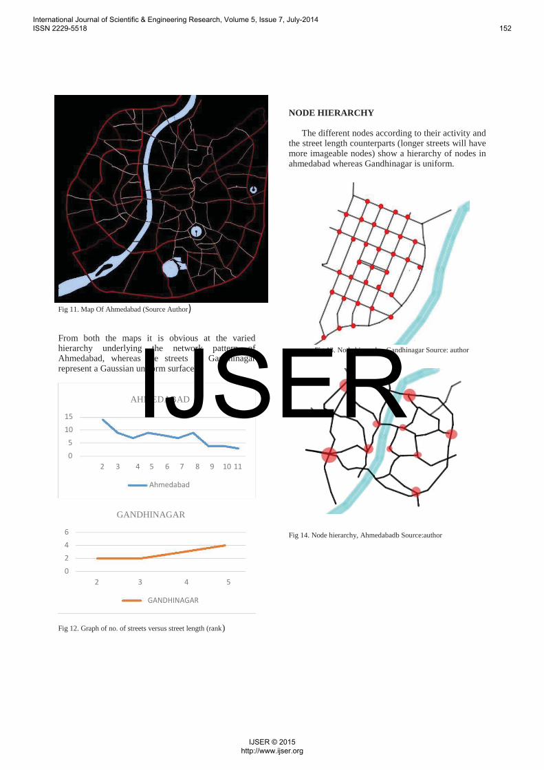
Fig 11. Map Of Ahmedabad (Source Author)
From both the maps it is obvious at the varied hierarchy underlying the network pattern of Ahmedabad, whereas the streets of Gandhinagar represent a Gaussian uniform surface.
AHMEDABAD 151050
2 3 4 5 6 7 8 9 10 11
Ahmedabad
GANDHINAGAR
6420
2 3 4 5
GANDHINAGAR
Fig 12. Graph of no. of streets versus street length (rank)
NODE HIERARCHY
The different nodes according to their activity and the street length counterparts (longer streets will have more imageable nodes) show a hierarchy of nodes in ahmedabad whereas Gandhinagar is uniform.
Fig 13. Node hierarchy, Gandhinagar Source: author
Fig 14. Node hierarchy, Ahmedabadb Source:author
International Journal of Scientific & Engineering Research, Volume 5, Issue 7, July-2014 ISSN 2229-5518 152
IJSER © 2015 http://www.ijser.org
IJSER

DISTRICT HEIRARCHY
Fig 15. Ahmedabad (source: author)
Fig 16. Gandhinagar (source: author)
It is evident from the district hierarchy in Ahmedabad the variances in its sizes, implying more imageable nodes and streets along its edges. Also the various modules interact with each other in coherent patterns (Salingaros, Complexity and Urban Coherence) not evident in the rigid Euclidean planning of similar sector modules in Gandhinagar.
CONNECTIVITY- The same map created for analyzing hierarchy can be put into use here. This is based on the fact that the longer a road the more the no. of connections into it (Lets call them major links). And also the hierarchy ranks clearly defines the longest roads and numbers them. The more the no. of roads the lesser the legibility of the city’s networks.
% of road networks: Ahmedabad
Major links lesser links Fig 17. Major vs minor road links
% of road networks, Gandhinagar
Major links Lesser links
Fig 18.
The graph of Ahmedabad shows a lower no. of major links connecting across large areas, thus clearly defining a hierarchy that is remember able. Further the no. of lesser connections imply an immensely permeable lower scale connectivity which is highly important in fractal urban designs. In larger scale connections the same level of connectivity is achieved with fewer no. of roads moving over larger distances. Thus the importance of ring roads. In Gandhinagar one can see that the distinction is vague and also the lesser links are too few to make a well permeable urban space. Thus the city is unconnected and illegible
International Journal of Scientific & Engineering Research, Volume 5, Issue 7, July-2014 ISSN 2229-5518 153
IJSER © 2015 http://www.ijser.org
IJSER

URBAN COHERANCE Further connectivity across the edges or roads
into different neighbourhoods or modules is efficient when there is sufficient spill over of activities across the connections. Such aspects can only be achieved through specific geometry as will be explained below.
In a coherent structure, a single element of any module will be influenced by all the local forces generated by the other elements of that module, and indirectly by elements outside the module. Neighboring elements will interact with each other, unless prevented from doing so by deliberate isolation. The positioning and even the shape of any particular element will thus be influenced by all the other elements in the whole (Alexander, 2000) The basic essence to urban coherence is through forces termed after the physical force of ‘coupling’. Coupling happens between two elements (ranging from large to smale scales) on if it possesses the following aspects:
Diversity in function, aesthetics of similar scale
o Permeability throughelements
o Permeability through interpenetration
o Catalysts or connectiveelements
Consider Ahmedabad:
Navrangpura area.
Fig 19.
International Journal of Scientific & Engineering Research, Volume 5, Issue 7, July-2014 ISSN 2229-5518 154
IJSER © 2015 http://www.ijser.org
IJSER

TABLE
Nodes Diversity Permeability Permeability Catalysts Conclusion in function, through through or aesthetics elements inter connective of similar penetration elements scale
A o Effective coupling through interpenetration of modules
B o o o Node not as active due to lesser scale of coupling
implies small scale node. C o o Catalysts like commercial
plaza helps coupling
1 o Effective coupling through central park area and thus
interpenetration of activities. 2 o o Catalysts like small street
shops, street hawkers crate
coupling along the interface. 3 o o o Lack of coupling due to lesser
permeable function diversity.
International Journal of Scientific & Engineering Research, Volume 5, Issue 7, July-2014 ISSN 2229-5518 155
IJSER © 2015 http://www.ijser.org
IJSER

Alphabets- Large scale interactions
Numerals – Small scale interactions.
The central vista area and its adjoining 4 sectors
Fig 20
TABLE
Nodes Diversity Permeability Permeability Catalysts Conclusion in function, through through or aesthetics elements inter connective of similar penetration elements scale
A o o o The central vista lies barrenand unused, dividing morethan coupling the sectors.B o o o Tough well maintained its
functionality is questionable.1 o o o o Empty spaces do not couple,
elements like wall divide.
2 o o o o No connections to permit permeability.
3 o o o o No division of smaller modules, limits functionality.
International Journal of Scientific & Engineering Research, Volume 5, Issue 7, July-2014 ISSN 2229-5518 156
IJSER © 2015 http://www.ijser.org
IJSER

Considering all the analysis made one can create a table to infer data from. To the list of already analysed headings the ideas of decomposition and socio-teporal time jumps can be added, which have not been analysed in detail as it lies beyond the scope of this dissertation.
TABLE OVERALL PATTERN ANALYSIS.
Aspects Hierarchy Connectivity Coupling Decomposition Spatio- temporal time jumps *
Ahmedabad
Hierarchy of Small scale The entire urban Fractal patterns nodes and connections space cannot be encompass a streets and within a successfully series of districts module decomposed into hierarchy enclosed high. individually scales thus
Large scale functioning units, negating such connections as the extents of scale jumps, limited. an isolated sadly such
module cannot be jumps in found. architectural
levels pertain.
Gandhinagar o o o o Gaussion More no. of The entire urban Scale jumps uniform large scale space can be are inherent to urban fabric connections, decomposed into the autonomous with only leaving isolated design centers limited no. internal rectangular in a of scales modules modules which consumerist
unconnected function egotist society. independently.
Spatio temporal time jumps imply any infrastructural development (of larger scale than its context) made in a limited and small scale of time.
International Journal of Scientific & Engineering Research, Volume 5, Issue 7, July-2014 ISSN 2229-5518 157
IJSER © 2015 http://www.ijser.org
IJSER

VI. INFERENCES“Euclidean geometric thinking in pursuit of
apparent geometric order is likely to produce a boring structure. A dead structure essentially lacks the hierarchy of scales or misses some levels of scale: either the smallest, the largest or the intermediate ones” – (Ben Jiang computing the image of a city)
Ahmedabad has inherent qualities of life within it that attracts a citizen to it and gives him a sense of identity and a sense of belonging and connectivity whereas Gandhinagar is more like a military outpost, isolates and un-imageable.
Thus a city that evolves naturally over a span of time shows a pattern similar in all its various levels of scale, a fractal pattern. Planning a city based on strict geometry takes away from the city a considerable quality, as Christopher Alexander puts it, its ‘Wholeness’. Thus the way forward in is a dire need in planning principles from strict geometric regulations to spontaneous yet controlled development and on algorithms that help evolve in a natural way, the fractal way.
VII. CONCLUSIONThus in a world consequentially evolved from
scratch across a great span of time till the present day existence, a world with all its complexities and difficulties coordinating with the nature of life stating nothing is in fact permanent nor perfect, a utopian world constructed as a offset of a group of people’s analysis of an urban environment does not create a coherent whole.It is empty and isolated with its existence rooted in the identity proclaimed loud and strong by its creators, but nothing beyond that. The spaces do not interact, the roads do not stand out, it is a puzzle, fit with multiple repetitive similar modules which instead of organizing confuses the citizens into a mental blur about the specific city. There is no tradition identifiable, no street life noticeable, it is but a apparent ‘utopia’ solely based on media exaggeration.
REFERENCES
Alexander, C. (1964). Notes on the Synthesis of Form, Harvard University Press, Cambridge,Massachusetts.
Alexander, C. (1965). "A City is Not a Tree" Architectural Forum vol. 122 April .
Alexander, C. (2002-05). “The nature of order”, Center for Environmental Structure: Berkeley, CA.
Alexander, C. (1979). The Timeless Way of Building, Oxford University Press, New York.
Alexander, C., Ishikawa, S., Silverstein, M., Jacobson, M., Fiksdahl-King, I. and Angel, S.
Alexander, C. (1977). A Pattern Language, Oxford University Press, New York.
Bin Jiang,”Computing the image of a city” Dabu, Navroz,(1979) “Evaluation of land utilization
and circulation system in an urban layout: case study-the new town of Gandhinagar”
Jacobs, Jane (1961) “Death and life of great American cities”
Krier, Leon, ”Architecture: Choice or Fate”
Salingaros, Nikos A. (2000),”The Structure of Pattern Languages”
Salingaros, Nikos A.(2005),”The Principles of urban structure”, Technepress, Amsterdam.
Salingaros, Nikos A.,” GeospatialAnalysis and Modelling of Urban Structure and Dynamics”
Salingaros, Nikos. A (2000),” Complexity and Urban Coherence”
Sejpal Shradha (1982),”Theory and city form- The case of Ahmedabad”
Pagliardini Pietro, Porta Sergio & Salingaros Nikos A (2009), “Geospatial analysis and living urban geometry”, Springer, New York.
Jiang B. (2012), Head/tail breaks: A new classification scheme for data with a heavy-tailed distribution, The Professional Geographer.
International Journal of Scientific & Engineering Research, Volume 5, Issue 7, July-2014 ISSN 2229-5518 158
IJSER © 2015 http://www.ijser.org
IJSER