Participatory Panchayati Raj Institutions and Awareness of Rural ...
15
70 Abstract This present paper examines the level of people’s participation in panchayat activities and level of people’s awareness about rural development programs. The study is done against the background of the Constitution (Seventy-Third Amendment) Act, 1992, and Bihar Panchayati Raj Act, 1993 and 2006, both of which aim to empower the rural people by strengthening the Gram Sabha. Gram Sabha happens to be the heart or the core of the panchayati raj system of local self-governance. The study is entirely based on a primary survey conducted in four villages of Atri Block in Gaya District of Bihar, which is among the least developed and most backward districts of India. 1. INTRODUCTION The village problem has to be solved by the villagers alone – Mahatma Gandhi. Gandhi’s idea of people’s participation in development of rural areas is still applicable to Indian villages. Despite making Panchayati-Raj a constitutional body and implementation of a large number of development schemes, they have not achieved much needed success in rural development. Hence, there is a need to make rural people more active and participatory in rural development. This was realized by giving legal status to Gram Sabha through Constitutions’ 73rd Amendment Act. The present paper discusses the issue of people’s participation in rural planning and development through Gram Sabha, and people’s awareness about rural development programs. The study is based on primary data collected through structured questionnaires and group discussions, which is supported by secondary data collected from the records maintained by various institutions of central, state and local self-government such as District Rural Development Agency (DRDA), Block Development Office (BDO), District Census Handbook (DCH), and the Panchayati Raj Institution (PRI) records. Households were selected through voter list of the village on the basis of simple stratified random sampling technique. A total of 45 households were selected with the help of random number table, fifteen each from general castes, Other Backward Castes (OBCs) and Scheduled Castes (SCs). Mr. Md. Rashid, presently pursuing Ph.D in Geography from Delhi School of Economics, University of Delhi. He obtained M.Phil in Geography from University of Delhi and MA in Geography from Aligarh Muslim University. Email: [email protected]. Dr. Anjan Sen, presently Assistant Professor in Geography at Delhi School of Economics, University of Delhi. He obtained Ph.D from IIT Delhi, Master of Planning in Regional Planning from SPA, and MA in Geography from JNU. Email: [email protected] Participatory Panchayati Raj Institutions and Awareness of Rural Development Programs in Bihar Md. Rashid and Dr. Anjan Sen Institute of Town Planners, India Journal 7 - 2, 70 - 84, April - June 2010 Md. Rashid and Dr. Anjan Sen
Transcript of Participatory Panchayati Raj Institutions and Awareness of Rural ...

70
AbstractThis present paper examines the level of people’s participation in panchayat activitiesand level of people’s awareness about rural development programs. The study is doneagainst the background of the Constitution (Seventy-Third Amendment) Act, 1992, andBihar Panchayati Raj Act, 1993 and 2006, both of which aim to empower the rural peopleby strengthening the Gram Sabha. Gram Sabha happens to be the heart or the core of thepanchayati raj system of local self-governance. The study is entirely based on a primarysurvey conducted in four villages of Atri Block in Gaya District of Bihar, which is among theleast developed and most backward districts of India.
1. INTRODUCTION
The village problem has to be solved by the villagers alone – Mahatma Gandhi.Gandhi’s idea of people’s participation in development of rural areas is stillapplicable to Indian villages. Despite making Panchayati-Raj a constitutional bodyand implementation of a large number of development schemes, they have notachieved much needed success in rural development. Hence, there is a need tomake rural people more active and participatory in rural development. This wasrealized by giving legal status to Gram Sabha through Constitutions’ 73rd AmendmentAct. The present paper discusses the issue of people’s participation in rural planningand development through Gram Sabha, and people’s awareness about ruraldevelopment programs.
The study is based on primary data collected through structured questionnairesand group discussions, which is supported by secondary data collected from therecords maintained by various institutions of central, state and local self-governmentsuch as District Rural Development Agency (DRDA), Block Development Office (BDO),District Census Handbook (DCH), and the Panchayati Raj Institution (PRI) records.Households were selected through voter list of the village on the basis of simplestratified random sampling technique. A total of 45 households were selected withthe help of random number table, fifteen each from general castes, Other BackwardCastes (OBCs) and Scheduled Castes (SCs).
Mr. Md. Rashid, presently pursuing Ph.D in Geography from Delhi School of Economics,University of Delhi. He obtained M.Phil in Geography from University of Delhi and MA inGeography from Aligarh Muslim University. Email: [email protected]. Anjan Sen, presently Assistant Professor in Geography at Delhi School of Economics,University of Delhi. He obtained Ph.D from IIT Delhi, Master of Planning in Regional Planningfrom SPA, and MA in Geography from JNU. Email: [email protected]
Participatory Panchayati Raj Institutions andAwareness of Rural DevelopmentPrograms in Bihar
Md. Rashid and Dr. Anjan Sen
Institute of Town Planners, India Journal 7 - 2, 70 - 84, April - June 2010
Md. Rashid and Dr. Anjan Sen
71
It is commonly accepted that rural development has three actors i.e. officials,elected representatives and villagers. Therefore, primary data has been collectedfrom all of them to know the exact situation of program implementation, and roleof Panchayats in the development of villages. Question was also asked to find outwhat rural people meant by development.
2. THE STUDY AREA
Bihar, historically among the most civilized and best administered states in India, istoday one of the country’s most impoverished and backward states. Its infrastructureincluding roads, power or communication networks are the poorest in India. Amajority of its population, over 90 percent works on land and produces food enoughto meet the immediate requirements of their families. After six decades ofindependence, Bihar is economically the most backward states in India having thelowest per capita income among all the states. Its per capita income (Net GDP atfactor cost at current prices) stands at a mere Rs.2,904 as against Rs. 5,781 forIndia and Rs. 9,643 for Punjab (CMIE, 1994). The state also has the lowest literacyrate among the major states with 47.5 percent against 100 percent literacy inKerala.
One of the obvious reasons for the economic backwardness and poverty of Bihar isits high population growth. The average per capita operational holding in the stateis 0.9 hectare (1985-1986) as against 1.7 hectare for India and 2.8 hectares in thePunjab. In addition, the natural productivity of agricultural land is very low. Biharhas an area of 94,163 km2 and a population of 82,878,796 as per 2001 census. Afterthe separation of Jharkhand in 2000, Bihar became an agricultural dominant statewith 87.5 percent of its population living in rural areas, almost all of whom areengaged in farming activities. It is among the poorest states of the country with 43percent of its people living below poverty line.
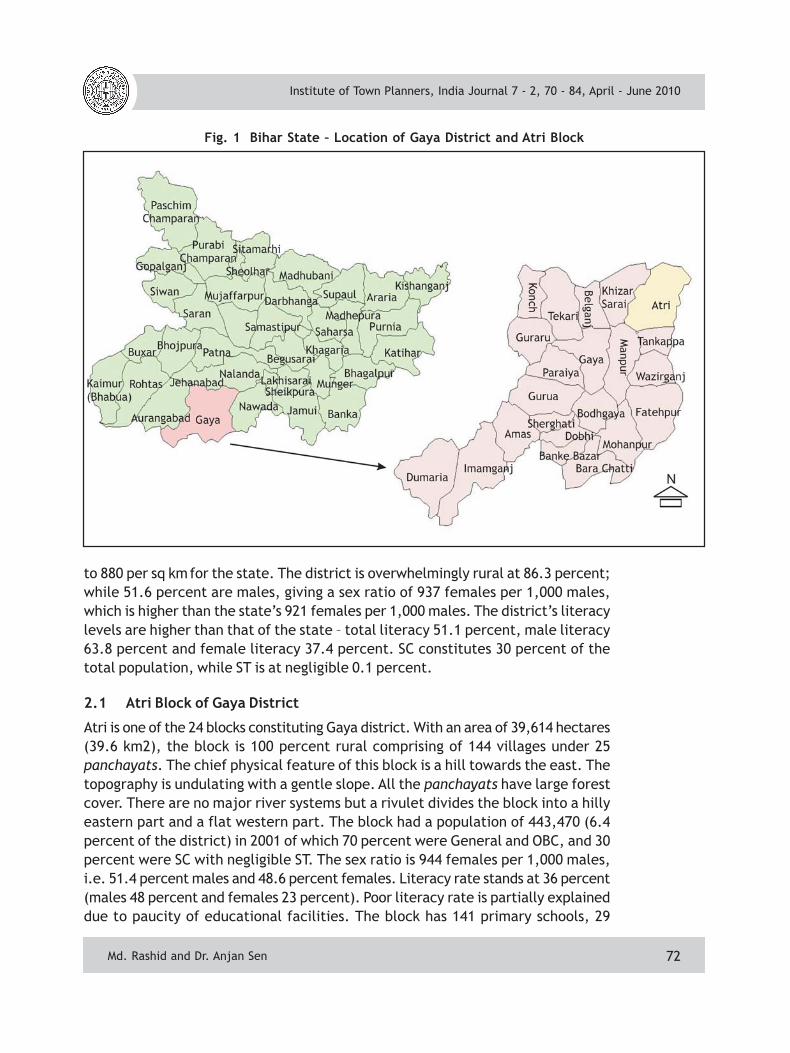
Gaya is a city of great antiquity, being the oldest cities of the world, having seenmany ups and downs of history. Today Gaya is one of the poorest and among themost backward districts of Bihar (Planning Commission, 1997). It is located in thesouthern part of the state, and is bounded by Jehanabad and Nalanda districts inthe north, Nawada district in the east, Aurangabad district in the west, and Palamauand Hazaribagh districts of Jharkhand state in the south. The district was createdin 1865 prior to which it was a part of Behar subdivision of Patna district. In 1973,Nawada and Aurangabad subdivisions of the district were separated into independentdistricts. Simultaneously, a new district of Jehanabad was also carved out (Fig. 1).
The district forms part of the Ganga plains but its southern and south-eastern partsare hilly being an extension of Chhotanagpur plateau. In 2001, the district had apopulation of 3,464,983 (4.2 percent of the state), spread over an area of 4,976km2 (5.3 percent of the state), giving a density of 696 persons per sq km, compared
Institute of Town Planners, India Journal 7 - 2, 70 - 84, April - June 2010
Md. Rashid and Dr. Anjan Sen
72
Fig. 1 Bihar State – Location of Gaya District and Atri Block
to 880 per sq km for the state. The district is overwhelmingly rural at 86.3 percent;while 51.6 percent are males, giving a sex ratio of 937 females per 1,000 males,which is higher than the state’s 921 females per 1,000 males. The district’s literacylevels are higher than that of the state – total literacy 51.1 percent, male literacy63.8 percent and female literacy 37.4 percent. SC constitutes 30 percent of thetotal population, while ST is at negligible 0.1 percent.
2.1 Atri Block of Gaya District
Atri is one of the 24 blocks constituting Gaya district. With an area of 39,614 hectares(39.6 km2), the block is 100 percent rural comprising of 144 villages under 25panchayats. The chief physical feature of this block is a hill towards the east. Thetopography is undulating with a gentle slope. All the panchayats have large forestcover. There are no major river systems but a rivulet divides the block into a hillyeastern part and a flat western part. The block had a population of 443,470 (6.4percent of the district) in 2001 of which 70 percent were General and OBC, and 30percent were SC with negligible ST. The sex ratio is 944 females per 1,000 males,i.e. 51.4 percent males and 48.6 percent females. Literacy rate stands at 36 percent(males 48 percent and females 23 percent). Poor literacy rate is partially explaineddue to paucity of educational facilities. The block has 141 primary schools, 29
Institute of Town Planners, India Journal 7 - 2, 70 - 84, April - June 2010
Md. Rashid and Dr. Anjan Sen

73
middle schools, 11 secondary schools, and only one senior-secondary school. Further,the block has 11 primary health sub-centers, 7 primary health centers, one healthcentre, and six hospitals. Only 17 percent of the roads are pucca or surfaced.
Social structure of the block is fractured along caste lines. Relative positions in thecaste hierarchy determine social relationships, behavioral patterns and culturalnorms. Socio-economic structure revolves around land ownership. Land reforms inBihar have had limited impact and land distribution is skewed in favor of few.Owners of large holdings belong to upper castes with some OBCs. The lower castesare small land owners or landless laborers. Although the lower castes form numericalmajority in any village, they reside outside the main village in tolas i.e. settlementclusters or hamlets.
Economic and social inequalities are interlinked. The power structure isconcentrated in the hands of the dominant castes, and people with political ormuscle power. They dominate the activities of the village as well as their owncommunity. These people control the flow of resources and technology comingfrom outside, and appropriate all the benefits meant for the weaker sections. Thephenomenon of the dominant caste and dominant personalities among all castes isa common feature to all villages in this region.
The lower castes face constant discrimination in their day to day life. Among themthe women are worst victims. Without any asset base, and several social disabilities,they are unable to sustain any economic activity, and have to depend on others formeans of livelihood. Consequently, they are exploited, and live at subsistencelevels without any savings. Poverty is directly related to land holdings as agricultureand its allied sectors are the main source of income. There are some small scaleindustries which provide employment to a limited workforce. Trading is limited toagricultural and forest products.
In 2001, less than one third i.e. 32.3 percent of the total population was workers,men at 44.3 percent and women at 19.7 percent. However, the block’s workforceparticipation rate is higher than that of the state. The workers are either main(36.7 percent) or marginal (63.3 percent). The main workers include 14.3 percentcultivators, 10.5 percent agricultural laborers, 3.1 percent in household industry,and 8.8 percent in other activities. Among the marginal workers, 95 percent werefemale. Irrigation facilities are poor. Total area irrigated from all sources was 26,820hectares (26.8 km2), which is 67.7 percent of the total geographical area. Importantsources of irrigation are wells, tube-wells, ponds, tanks, and rivers. The block isconnected by a state highway to the district headquarter Gaya, which is the onlymeans of communication. It is connected with few rural roads, which serve majorvillages and markets. There is no national highway.
Institute of Town Planners, India Journal 7 - 2, 70 - 84, April - June 2010
Md. Rashid and Dr. Anjan Sen

74
Fig. 2 Atri Block – Location of Dihuri and Saren Gram Panchayats
Atri Block consists of 25 Panchayats, of which two Dihuri and Saren has been selectedfor the study. The selection has been done on the basis of physical features andconnectivity to district and block headquarters. Further, for more intensive study,two villages each have been selected from the two Panchayats of Dihuri and Upthu,and Saren and Natesar respectively. Here the selection has been arrived at on thebasis of population and the village to which the headman or Mukhia of the Panchayatbelongs (Fig. 2).
2.2 Dihuri Gram Panchayat
Dihuri Gram Panchayat comprises six villages, andhas an area of 1,069 hectares. It has plaintopography with a river on the eastern margins. Itis 20 km from the district headquarters and 10 kmfrom the block headquarters. In 2001 its populationwas 8,614, of whom 29 percent were SC andremaining were General and OBC. There was no
Table 1 Population of Dihuri GramPanchayat, 2001
Source: District Census Handbook, Gaya, 2001
Categories Male Female Total %General 3, 201 2, 916 6, 117 71.0SC 1, 260 1, 237 2, 497 29.0ST 0 0 0 0.0Total 4, 461 4, 153 8, 614 100.0
Institute of Town Planners, India Journal 7 - 2, 70 - 84, April - June 2010
Md. Rashid and Dr. Anjan Sen

75
ST in this Panchayat (see Table 1). The sex ratio was in favor of male i.e. 52percent males and 48 percent females.
Agriculture is the major source of income and livelihood of the people. Irrigationfacilities in this panchayat are relatively good, and the total area irrigated is 1,015hectares. Important sources of irrigation are wells, tube wells, rivers and lakes.There is no culturable wasteland and forest in this Panchayat. The Panchayat iswell connected by all weather motorable roads to both the district and blockheadquarters. The road was repaired last year under Pradhan Mantri Gram SadakYojana (PMGSY).
2.3 Saren Gram Panchayat
Saren Gram Panchayat has four villages with an area of 1,788 hectares. It hasundulating topography comprising of low hillsinterspersed with valleys. The panchayat hasseveral springs. Part of Rajgir, the capital of thehistoric Mauryan Empire, the panchayat has severalancient habitations. It also finds extensive mentionin travelogues of Francis Buchanan, who hadtraveled across the Gaya district in 1811-1812. Lastyear some idols from the Mauryan period wereexcavated. In 2001 census, Saren Gram Panchayathad recorded a population of 11,614 of whom 25.5percent were SC, 0.1 percent ST and remaining
74.4 percent were OBC and General (Table 2). The sex ratio was in favor of malei.e. 51 percent male and 49 percent females.
Agriculture is the principal economic activity of the people. Some people of SCand ST community generate income from minor forest products. Large parts of thepanchayat are under forest (336 hectares or 19 percent), culturable wasteland(138 hectares or 8 percent), or not-available for cultivation (247 hectares or 14percent). The panchayat has poor irrigation facilities compared to other panchayatsin the block. Total irrigated area from all sources is 894 hectares or 50 percent, theimportant sources of irrigation being ponds, tanks and wells. The panchayat is notconnected with all weather motorable roads, which contributes to its backwardness.People have to cover a distance of 6–7 km to catch a bus.
3. DIHURI, UPTHU, SAREN AND NATESAR VILLAGES
Four villages were selected for intensive study – Dihuri and Upthu from DihuriGram Panchayat, and Saren and Natesar from Saren Gram Panchayat. The totalgeographical area of the study area is 1,828 hectares, of which 1,433 hectares (78percent) is Net Sown Area, 144 hectares (8 percent) is Forest, 59 hectares (3 percent)is Culturable Wasteland, and 192 hectares (11 percent) not Available for Cultivation.
Table 2 Population of Saren GramPanchayat, 2001
Source: District Census Handbook, Gaya, 2001
Categories Male Female Total %General 4, 406 4, 229 8, 635 74.4SC 1, 524 1, 438 2, 962 25.5ST 7 10 17 0.1Total 5, 937 5, 677 11, 614 100
Institute of Town Planners, India Journal 7 - 2, 70 - 84, April - June 2010
Md. Rashid and Dr. Anjan Sen
76
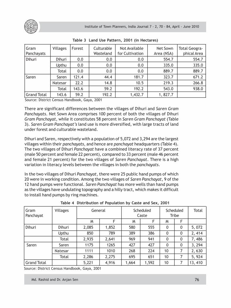
There are significant differences between the villages of Dihuri and Saren GramPanchayats. Net Sown Area comprises 100 percent of both the villages of DihuriGram Panchayat, while it constitutes 58 percent in Saren Gram Panchayat (Table3). Saren Gram Panchayat’s land use is more diversified, with large tracts of landunder forest and culturable wasteland.
Dihuri and Saren, respectively with a population of 5,072 and 3,294 are the largestvillages within their panchayats, and hence are panchayat headquarters (Table 4).The two villages of Dihuri Panchayat have a combined literacy rate of 37 percent(male 50 percent and female 22 percent), compared to 33 percent (male 46 percentand female 21 percent) for the two villages of Saren Panchayat. There is a highvariation in literacy levels between the villages in both the panchayats.
In the two villages of Dihuri Panchayat, there were 25 public hand pumps of which20 were in working condition. Among the two villages of Saren Panchayat, 9 of the12 hand pumps were functional. Saren Panchayat has more wells than hand pumpsas the villages have undulating topography and a hilly tract, which makes it difficultto install hand pumps by ring machines.
Table 4 Distribution of Population by Caste and Sex, 2001
Source: District Census Handbook, Gaya, 2001
Gram Villages General Scheduled Scheduled TotalPanchayat Caste Tribe M F M F M F Dihuri Dihuri 2,085 1,852 580 555 0 0 5, 072
Upthu 850 789 389 386 0 0 2, 414Total 2,935 2,641 969 941 0 0 7, 486
Saren Saren 1175 1265 427 427 0 0 3, 294Natesar 1111 1010 268 224 10 7 2, 630
Total 2,286 2,275 695 651 10 7 5, 924Grand Total 5,221 4,916 1,664 1,592 10 7 13, 410
Table 3 Land Use Pattern, 2001 (in Hectares)
Source: District Census Handbook, Gaya, 2001
Gram Villages Forest Culturable Not Available Net Sown Total Geogra-Panchayats Wasteland for Cultivation Area (NSA) phical AreaDihuri Dihuri 0.0 0.0 0.0 554.7 554.7
Upthu 0.0 0.0 0.0 335.0 335.0Total 0.0 0.0 0.0 889.7 889.7
Saren Saren 121.4 44.4 181.7 323.7 671.2Natesar 22.2 14.8 10.5 219.3 266.8
Total 143.6 59.2 192.2 543.0 938.0Grand Total 143.6 59.2 192.2 1,432.7 1, 827.7
Institute of Town Planners, India Journal 7 - 2, 70 - 84, April - June 2010
Md. Rashid and Dr. Anjan Sen

77
All the four villages have primary school. While two villages, one in each panchayathave middle schools and Dihuri Village has a high school. There is no high school inthe Saren panchayat and the nearest is located more than 10 km away, whichremains inaccessible due to absence of transport facility. Saren Village has a museum.
3.1 Profile of Respondents
The household schedule was canvassed on 180 respondents from the four selectedvillages. Of the 180 respondents, 38 percent were beneficiaries of a rural
development scheme, while 62 percent were non-beneficiaries. Among the 67 beneficiaries, 67percent were SC (Table 5). Of the 67 beneficiaries,40 benefited from Indira Awas Yojana (IAY), 25 fromAnnapurna Scheme, and 3 each from JawaharRozgar Yojana (JRY) and Antoyadaya Scheme. Fourbeneficiaries benefited from more than onescheme, and there were few instances ofbeneficiaries having received benefits from thesame scheme more than once. About 57 percentrespondents fell Below Poverty Line (BPL).
Owing to social restrictions and traditions i.e. malesnot allowed free interaction with females, thus 92 percent of the respondentswere male. This explains dominance of males among the respondents. Among therespondents, 49 percent were illiterate, and 51 percent were literates. The
education level of 91 literate respondentswas – Primary (37), Middle (30), High orSenior Secondary (7), Graduates (14) andPostgraduate (3). Among therespondents, 120 (67 percent) wereHindus and 60 (33 percent) were Muslims.The age structure of the respondents wasas follows: 15 percent below 30 years, 28percent between 30-40 years, 31 percentbetween 40-50 years, 22 percentbetween 50-60 years, and 4 percentabove 60 years. The occupationalstructure of the respondents was as
follows – Farmers (48), Agricultural Laborers (68), Secondary Workers (31),Government Service (18), Unemployed (6), and Students (9) (Table 6).
4. PEOPLES’ PARTICIPATION
The term ‘people’s participation’ has several connotations. It refers to the ideathat people have the right to decide their own needs, and can be interpreted in
Source: Primary Field Survey, 2006
Table 5 Rural Development Schemes –Beneficiaries by Caste
Caste General OBC SC TotalDihuri 2 5 10 17Upthu 2 6 13 21Saren 0 4 14 18Natesar 0 3 8 11Total 4 18 45 67
Table 6 Occupational Status of the Respondents
Source: Primary Field Survey, 2006
Village Farmer Agricultural Secondary Govt. OthersLaborers Workers Service
Dihuri 33% 29% 20% 11% 7%Upthu 24% 51% 15% 1% 9%Saren 24% 35% 15% 18% 8%Natesar 24% 36% 18% 11% 11%Total 27% 38% 17% 10% 8%
Institute of Town Planners, India Journal 7 - 2, 70 - 84, April - June 2010
Md. Rashid and Dr. Anjan Sen
78
two ways. Firstly, it means people’s involvement and engagement in the developmentprojects during all its phases including planning, implementation, monitoring andevaluation. Secondly, it means group action in the form of Self Help Groups (SHG),Social Action Groups (SAG), Non-Governmental Organizations (NGO), etc. People’sparticipation through Gram Sabha comes under the first definition. Nowadayscommunity participation is more commonly used instead of people’s participation.
The concept of people’s participation is as old as our civilization. It developedwithin the society earlier in the villages and later in towns and cities. In Indianvillages, the legacy of people’s participation is very old and most of the workwhich benefits the whole village was done through people’s participation withoutany discrimination of caste and class. People actively participated in managingcommon property resources. This is called ‘Kar Sewa’ (community action). In thecontemporary period, the concept of people’s participation was first used in 1950s,when Community Development Programme (CDP) was launched in the First Five-year Plan (1951-1956). At that time it carried limited meaning as it referred topersuading people to adopt innovative agricultural inputs and practices. Its meaninghas since been enlarged. In 1960s, with the introduction of Panchayati RajInstitutions, it took on a different connotation, denoting people’s participation indecision making processes. During 1990s after the implementation of Constitution’s73rd Amendment Act, its meaning changed further. Now it not only means peoples’participation in decision making but also in its implementation, monitoring andevaluation.
4.1 Types of Peoples’ Participation
• Passive: People are informed about what is happening. Thus they are notsuccessful. Rural development programs in India are of this type;
• Informative: People are requested to answer questions by experts but are notincluded in planning and decision making;
• Material or Incentive: People provide resources, like labor in return for cashor kind e.g. Rural Employment Guarantee Scheme;
• Consultative: People are consulted, but experts define problems and findsolutions;
• Functional: People form local groups to meet their needs but are dependenton outsiders for finance;
• Interactive: People participate in need assessment, planning, decision making,and maintaining structures and practices; and
• Self-mobilized: People take initiatives independent of outsiders, and are incontrol over the cycle of development process. This is urgently needed in Indiafor a faster and sustainable rural development. To enable this, constitution of
Institute of Town Planners, India Journal 7 - 2, 70 - 84, April - June 2010
Md. Rashid and Dr. Anjan Sen

79
India has provided for a Gram Sabha as a forum for participation of rural peoplein their development.
4.2 People’s Participation through Gram Sabha
Only an active involvement of people and community through participation canbring about a sustainable rural transformation. Active peoples’ participation is theprerequisite condition for successful implementation of rural developmentprograms. The idea of peoples’ active participation in rural development wasrealized through mandatory provision of Gram Sabha in the Constitution’s 73rdAmendment Act. The Gram Sabha is an institution giving collective strength to thepoor and deprived, who in turn gain self confidence to stand on their own andregain the spirit of self reliance and human dignity.
Gram Sabha means a body consisting of persons registered in the electoral rollsrelating to a village comprised within the area of Panchayat at the village level. InBihar, every revenue village has been considered as a Gram Sabha. Since a revenuevillage in Bihar has an average population more than 3,000, it is very difficult toassemble them all at single place and time. There must be provision of Ward Sabha,and villages of Bihar have been divided into several wards with their respectiveward members.
A Gram Sabha may exercise such powers and perform such functions at the villagelevel as the legislature of a state may by law provide. Thus the ball is in the statelegislature’s court, which for all practical purpose means the state government.The members of Gram Sabha have nothing to do except constituting the Sabha.The state government dominates, and Gram Sabhas faces a perpetual situation ofdependency and uncertainty. The Government of Bihar has delegated followingpowers and functions to Gram Sabha:
Powers of Gram Sabha
• To prepare the annual plan of the Gram Panchayat;
• To pass annual budget of the Panchayat;
• To prepare development reports of the last and next year of the panchayat;and
• To constitute vigilance committees.
Functions of Gram Sabha
• To help in the implementation of rural development programs in the village.
• To identify beneficiaries of different rural development programs.
• To provide funds for or help in the social welfare programs of the village.
Institute of Town Planners, India Journal 7 - 2, 70 - 84, April - June 2010
Md. Rashid and Dr. Anjan Sen

80
• To help in the education and family welfare programs in the village.
• To demand income and expenditure report under various rural developmentschemes from Gram Panchayat.
5. FUNCTIONING OF GRAM SABHA IN THE SELECTED VILLAGES
As the Gram Sabha prepares plans and budgets, and audits reports, one may arguethat it has effective control over the Gram Panchayat, but not necessarily inreality. The legal position is different. The Gram Sabha makes recommendationsand suggestions, and the Gram Panchayat gives due consideration to itsrecommendations and suggestions. There is no legal obligation on the GramPanchayat to accept the recommendations and suggestions of Gram Panchayat.This has created the problem of Mukhia Raj instead of Gram Swaraj. This hasmade the Gram Sabha meaningless.
In the surveyed villages a number of people had not even heard the name of GramSabha, so participation is a distant goal. They usually called it Aam Sabha (GeneralAssembly), which is held once in five years to elect new members of the panchayats.Besides, instead of one Gram (Aam) Sabha and elected Panchayat per revenuevillage, it is organized over an average of four revenue villages. Many of the electedpanchayat members are not aware of Gram Sabha, and its powers and functions.Panchayat members and Block officials allege that Gram Sabhas are held regularlyin these villages but villagers do not participate.
Villagers claim non-participation because their plans and demands are notconsidered, and every thing is decided by the Mukhia, officials and dominantpersonality of major castes and communities. Thus they consider it wastage oftime. Of the 180 respondents, 17 percent regularly participated in the Gram Sabhameetings, 35 percent seldom participated and a whopping 48 percent never
Fig. 3 People’s Participation in Gram Sabha Meetings by Village
Institute of Town Planners, India Journal 7 - 2, 70 - 84, April - June 2010
Md. Rashid and Dr. Anjan Sen
81
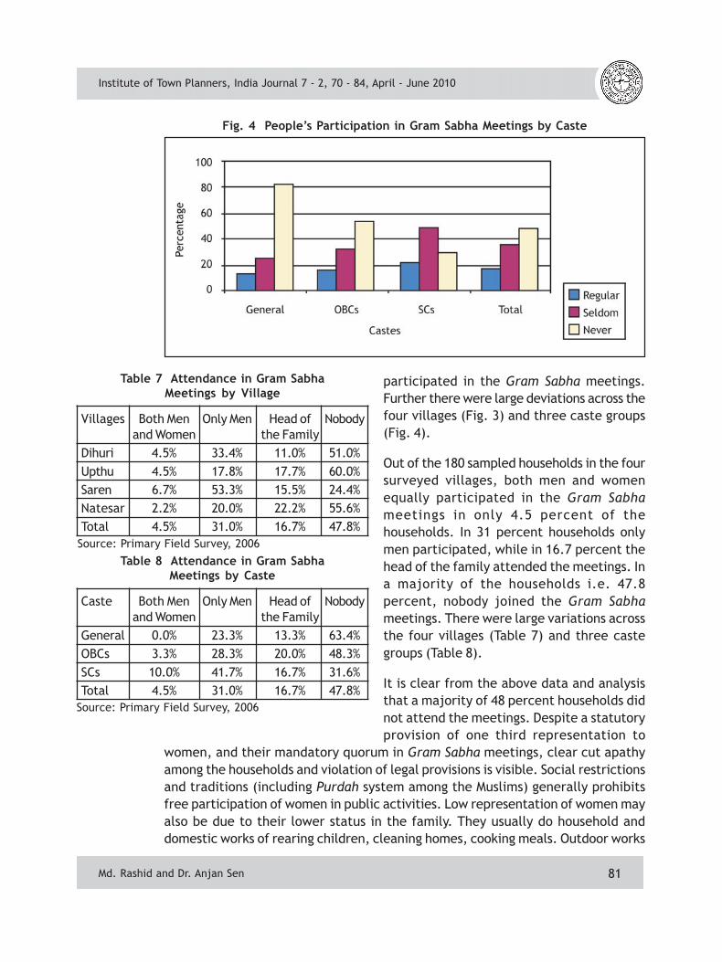
Fig. 4 People’s Participation in Gram Sabha Meetings by Caste
Table 7 Attendance in Gram SabhaMeetings by Village
Source: Primary Field Survey, 2006
Villages Both Men Only Men Head of Nobodyand Women the Family
Dihuri 4.5% 33.4% 11.0% 51.0%Upthu 4.5% 17.8% 17.7% 60.0%Saren 6.7% 53.3% 15.5% 24.4%Natesar 2.2% 20.0% 22.2% 55.6%Total 4.5% 31.0% 16.7% 47.8%
Table 8 Attendance in Gram SabhaMeetings by Caste
Source: Primary Field Survey, 2006
Caste Both Men Only Men Head of Nobodyand Women the Family
General 0.0% 23.3% 13.3% 63.4%OBCs 3.3% 28.3% 20.0% 48.3%SCs 10.0% 41.7% 16.7% 31.6%Total 4.5% 31.0% 16.7% 47.8%
participated in the Gram Sabha meetings.Further there were large deviations across thefour villages (Fig. 3) and three caste groups(Fig. 4).
Out of the 180 sampled households in the foursurveyed villages, both men and womenequally participated in the Gram Sabhameetings in only 4.5 percent of thehouseholds. In 31 percent households onlymen participated, while in 16.7 percent thehead of the family attended the meetings. Ina majority of the households i.e. 47.8percent, nobody joined the Gram Sabhameetings. There were large variations acrossthe four villages (Table 7) and three castegroups (Table 8).
It is clear from the above data and analysisthat a majority of 48 percent households didnot attend the meetings. Despite a statutoryprovision of one third representation to
women, and their mandatory quorum in Gram Sabha meetings, clear cut apathyamong the households and violation of legal provisions is visible. Social restrictionsand traditions (including Purdah system among the Muslims) generally prohibitsfree participation of women in public activities. Low representation of women mayalso be due to their lower status in the family. They usually do household anddomestic works of rearing children, cleaning homes, cooking meals. Outdoor works
Institute of Town Planners, India Journal 7 - 2, 70 - 84, April - June 2010
Md. Rashid and Dr. Anjan Sen
82
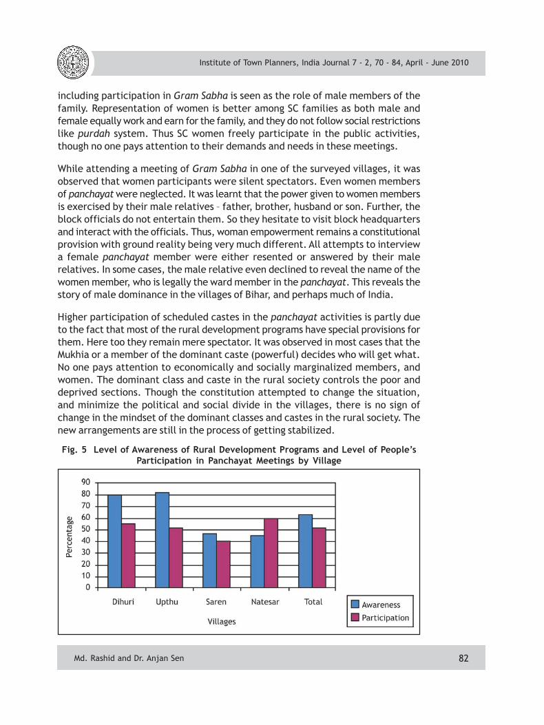
Fig. 5 Level of Awareness of Rural Development Programs and Level of People’sParticipation in Panchayat Meetings by Village
including participation in Gram Sabha is seen as the role of male members of thefamily. Representation of women is better among SC families as both male andfemale equally work and earn for the family, and they do not follow social restrictionslike purdah system. Thus SC women freely participate in the public activities,though no one pays attention to their demands and needs in these meetings.
While attending a meeting of Gram Sabha in one of the surveyed villages, it wasobserved that women participants were silent spectators. Even women membersof panchayat were neglected. It was learnt that the power given to women membersis exercised by their male relatives – father, brother, husband or son. Further, theblock officials do not entertain them. So they hesitate to visit block headquartersand interact with the officials. Thus, woman empowerment remains a constitutionalprovision with ground reality being very much different. All attempts to interviewa female panchayat member were either resented or answered by their malerelatives. In some cases, the male relative even declined to reveal the name of thewomen member, who is legally the ward member in the panchayat. This reveals thestory of male dominance in the villages of Bihar, and perhaps much of India.
Higher participation of scheduled castes in the panchayat activities is partly dueto the fact that most of the rural development programs have special provisions forthem. Here too they remain mere spectator. It was observed in most cases that theMukhia or a member of the dominant caste (powerful) decides who will get what.No one pays attention to economically and socially marginalized members, andwomen. The dominant class and caste in the rural society controls the poor anddeprived sections. Though the constitution attempted to change the situation,and minimize the political and social divide in the villages, there is no sign ofchange in the mindset of the dominant classes and castes in the rural society. Thenew arrangements are still in the process of getting stabilized.
Institute of Town Planners, India Journal 7 - 2, 70 - 84, April - June 2010
Md. Rashid and Dr. Anjan Sen

83
Fig. 6 Level of Awareness of Rural Development Programs and Level of People’sParticipation in Panchayat Meetings by Caste
Level of Awareness People’s Participation
Villages Literates Illiterates Literates Illiterates
Dihuri 88.0% 70.0% 72.6% 40.0%
Upthu 91.7% 76.0% 50.0% 38.1%
Saren 78.9% 23.0% 63.1% 60.4%
Natesar 60.9% 31.8% 52.1% 40.2%
Total 80.2% 48.3% 59.3% 44.6%
Table 9 Level of Awareness and People’s Participation
Source: Primary Field Survey, 2006
Among the respondents, 80 percentof the literate and 48 percent of theilliterate were aware of one or otherprograms while 59 percent of literateand 45 percent of illiterateparticipated in the panchayatmeetings (Table 9).
The above analysis clearly indicates arelationship between the level ofawareness of different ruraldevelopment programs and level of
5.1 Level of Awareness and People’s Participation
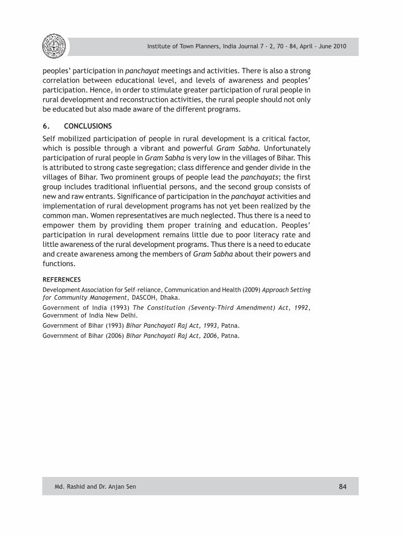
Effective rural development and rural reconstruction requires active participationof people in large number at local level. The factor determining rural people’sparticipation is the level of awareness of different programs and their perceivedbenefits in their lives, which in turn is determined by the level of educationespecially functional education of the people. This fact is very much noticeable inthe four surveyed villages. In these villages, 63 percent of the respondents wereaware of one or more rural development schemes, while their participation in thepanchayat meetings is 52 percent whether regular or seldom (Fig. 5). The level ofawareness of different programs was highest among SC at 72 percent. Theirparticipation in panchayat meetings was also the highest at 70 percent. On theother hand, level of awareness was lowest at 53 percent among respondents ofgeneral castes. Simultaneously, their participation in panchayat meetings was alsothe lowest at 38 percent respondents (Fig. 6).
Institute of Town Planners, India Journal 7 - 2, 70 - 84, April - June 2010
Md. Rashid and Dr. Anjan Sen
84
peoples’ participation in panchayat meetings and activities. There is also a strongcorrelation between educational level, and levels of awareness and peoples’participation. Hence, in order to stimulate greater participation of rural people inrural development and reconstruction activities, the rural people should not onlybe educated but also made aware of the different programs.
6. CONCLUSIONS
Self mobilized participation of people in rural development is a critical factor,which is possible through a vibrant and powerful Gram Sabha. Unfortunatelyparticipation of rural people in Gram Sabha is very low in the villages of Bihar. Thisis attributed to strong caste segregation; class difference and gender divide in thevillages of Bihar. Two prominent groups of people lead the panchayats; the firstgroup includes traditional influential persons, and the second group consists ofnew and raw entrants. Significance of participation in the panchayat activities andimplementation of rural development programs has not yet been realized by thecommon man. Women representatives are much neglected. Thus there is a need toempower them by providing them proper training and education. Peoples’participation in rural development remains little due to poor literacy rate andlittle awareness of the rural development programs. Thus there is a need to educateand create awareness among the members of Gram Sabha about their powers andfunctions.
REFERENCES
Development Association for Self–reliance, Communication and Health (2009) Approach Settingfor Community Management, DASCOH, Dhaka.
Government of India (1993) The Constitution (Seventy-Third Amendment) Act, 1992,Government of India New Delhi.
Government of Bihar (1993) Bihar Panchayati Raj Act, 1993, Patna.
Government of Bihar (2006) Bihar Panchayati Raj Act, 2006, Patna.
Institute of Town Planners, India Journal 7 - 2, 70 - 84, April - June 2010
Md. Rashid and Dr. Anjan Sen