Part I - Text by
66
RESULTS OF EXPLORATORY DRILLING FROM FEBRUARY 1992 TO JULY 1992, COAL RESOURCE EXPLORATION AND ASSESSMENT PROGRAM (COALREAP), THAR DESERT, LAKHRA SOUTH, INDUS PLAIN, AND ADJACENT AREAS, SINDH PROVINCE, PAKISTAN Part I - Text by John R. SanFilipo 1 , Altaf H. Chandio 2 , Shafique A. Khan 2 , Rafiq A. Khan 2 , and Abbas All Shah 2 Open-File Report 94-595 Prepared jointly by the Geological Survey of Pakistan and the U.S. Geological Survey, under the auspices of the U.S. Agency for International Development '-U.S.Geological Survey, 956 National Center, Reston VA 22092 2 Geological Survey of Pakistan, 42-R, Block-6, PECHS, Karachi This report is preliminary and has not been reviewed for conformity with U.S. Geological Survey editorial standards and stratigraphic nomenclature. Any use of trade names is for descriptive purposes only and does not imply endorsement by the USGS. 1994
Transcript of Part I - Text by

RESULTS OF EXPLORATORY DRILLING FROM FEBRUARY 1992 TO JULY 1992,
COAL RESOURCE EXPLORATION AND ASSESSMENT PROGRAM (COALREAP),
THAR DESERT, LAKHRA SOUTH, INDUS PLAIN, AND ADJACENT AREAS,
SINDH PROVINCE, PAKISTAN
Part I - Text
by
John R. SanFilipo1 , Altaf H. Chandio2 , Shafique A. Khan2 ,
Rafiq A. Khan2 , and Abbas All Shah2
Open-File Report 94-595
Prepared jointly by the Geological Survey of Pakistan and the U.S. Geological Survey, under the auspices of the U.S. Agency for International Development
'-U.S.Geological Survey, 956 National Center, Reston VA 22092
2Geological Survey of Pakistan, 42-R, Block-6, PECHS, Karachi
This report is preliminary and has not been reviewed for conformity with U.S. Geological Survey editorial standards and stratigraphic nomenclature. Any use of trade names is for descriptive purposes only and does not imply endorsement by the USGS.
1994

PREFACE
This report was originally one portion of a proprietary
administrative report that was prepared by the Geological Survey
of Pakistan and the U.S. Geological Survey (USGS) for the U.S.
Agency for International Development. As such it received a
limited distribution within Pakistan as Geological Survey Project
Report (IR)PK-108. Because of it's length, (IR)PK-108 has been
divided into five parts for its release to the public by USGS.
This part of the report contains introductory text that is meant
to accompany the basic borehole data, which are presented in
other reports as follows (borehole numbers in parenthesis):
Open-File Report 94-596-A Indus Plain area(BN- 1,KUH-1,KUH-2)
Open-File Report 94-596-B Lakhra south area(LS- 1,LS-2,LS-3,LS-4)
Open-File Report 94-596-C Meting-Jhimpir extensions<SO-1,SO-2,SO-3,SO-4,SO-5)
Open-File Report 94-596-D Thar Desert area(TP-1,TP-2,TP-3,TP-4)

CONTENTS
page
ABSTRACT................................................. 1
PART I. SUMMARY OF DRILLIING AND RELATED ACTIVITIES..... 2
Introduction........................................ 3
Proj ect background............................. 3
Previous work.................................. 7
Present study.................................. 8
Purpose and scope of work...................... 11
Acknowledgement and responsibilities........... 11
Drilling summary.................................... 14
Location and access............................ 14
Drilling operations............................ 19
Drilling statistics............................ 28
Data collection..................................... 29
Rock sampling and description.................. 29
Coal sampling methods.......................... 30
Gas desorption testing......................... 33
Geophysical logging ........................... 36
Preliminary conclusions and recommendations......... 42
South Lakhra................................... 42
Sohnari areas.................................. 43
Indus Plain.................................... 45
Thar Desert.................................... 47
References cited.................................... 51
Appendices.......................................... 55
Appendix 1. Supplemental information.......... 56
Appendix 2. Preliminary coal intercepts....... 60
ii

CONTENTS (cont'd)
page
PART II. DRILL-HOLE DATA................................. *
Explanation of lithologic symbols................... *
Drilling logs, lithologic descriptions andgeophysical logs.................................... *
ILLUSTRATIONS
Figure 1. Index map, coal fields of Pakistan............ 4
2. Borehole location map, Lakhra, Sonda, andMeting-Jhimpir coalfields and adjacent areas.. 15
3. Detailed borehole location map, northernSonda coalfield and adjacent areas............ 16
4. Borehole location map, Thar Desert area....... 17
TABLES
Table 1. Previous COALREAP drilling, Sindh Province..... 9
2. USGS proj ect personnel......................... 13
3. GSP project personnel.......................... 13
4. Surveyed drill-hole coordinates and elevations. 20
5. Drilling statistics............................ 26
6. Results of gas desorption tests................ 35
7. List of geophysical logs....................... 39
see OF 94-596-A, OF 94-596-B, and OF 94-596-C
ill
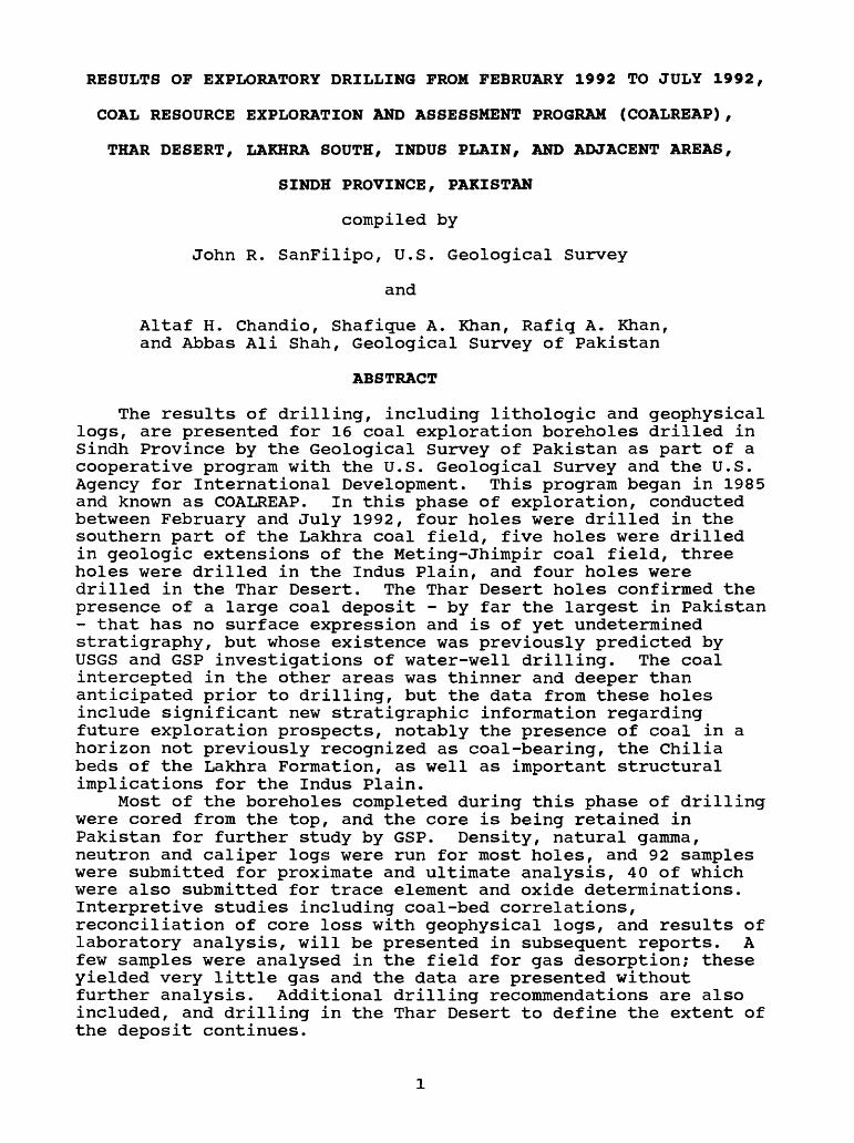
RESULTS OF EXPLORATORY DRILLING FROM FEBRUARY 1992 TO JULY 1992,
COAL RESOURCE EXPLORATION AND ASSESSMENT PROGRAM (COALREAP),
THAR DESERT, LAKHRA SOUTH, INDUS PLAIN, AND ADJACENT AREAS,
SINDH PROVINCE, PAKISTAN
compiled by
John R. SanFilipo, U.S. Geological Survey
and
Altaf H. Chandio, Shafique A. Khan, Rafiq A. Khan, and Abbas Ali Shah, Geological Survey of Pakistan
ABSTRACT
The results of drilling, including lithologic and geophysical logs, are presented for 16 coal exploration boreholes drilled in Sindh Province by the Geological Survey of Pakistan as part of a cooperative program with the U.S. Geological Survey and the U.S. Agency for International Development. This program began in 1985 and known as COALREAP. In this phase of exploration, conducted between February and July 1992, four holes were drilled in the southern part of the Lakhra coal field, five holes were drilled in geologic extensions of the Meting-Jhimpir coal field, three holes were drilled in the Indus Plain, and four holes were drilled in the Thar Desert. The Thar Desert holes confirmed the presence of a large coal deposit - by far the largest in Pakistan - that has no surface expression and is of yet undetermined stratigraphy, but whose existence was previously predicted by USGS and GSP investigations of water-well drilling. The coal intercepted in the other areas was thinner and deeper than anticipated prior to drilling, but the data from these holes include significant new stratigraphic information regarding future exploration prospects, notably the presence of coal in a horizon not previously recognized as coal-bearing, the Chilia beds of the Lakhra Formation, as well as important structural implications for the Indus Plain.
Most of the boreholes completed during this phase of drilling were cored from the top, and the core is being retained in Pakistan for further study by GSP. Density, natural gamma, neutron and caliper logs were run for most holes, and 92 samples were submitted for proximate and ultimate analysis, 40 of which were also submitted for trace element and oxide determinations. Interpretive studies including coal-bed correlations, reconciliation of core loss with geophysical logs, and results of laboratory analysis, will be presented in subsequent reports. A few samples were analysed in the field for gas desorption; these yielded very little gas and the data are presented without further analysis. Additional drilling recommendations are also included, and drilling in the Thar Desert to define the extent of the deposit continues.

PART I
SUMMARY OF DRILLING AND RELATED ACTIVITIES
by
John R. SanFilipo1 , Altaf H. Chandio2 ,
Shafique A. Khan2 , Rafiq A. Khan2
and Abbas A. Shah2
'-U.S. Geological Survey
2Geological Survey of Pakistan

PART I. SUMMARY OF DRILLING AND RELATED ACTIVITIES
by
John R. SanFilipo U.S. Geological Survey
andAltaf H. Chandio, Shafique A. Khan, Rafiq A. Khan and Abbas A. Shah
Geological Survey of Pakistan
Introduction
Project background
Between August 1985 and June 1993, the United States
Geological Survey (USGS) and the Geological Survey of Pakistan
(GSP) engaged in a cooperative investigation of the coal
resources of Pakistan, known as COALREAP (Coal Resource
Assessment and Exploration Program). COALREAP was Component 2A
of the joint Government of Pakistan (GOP) and United States
Agency for International Development (USAID) Energy Planning and
Development Project (EP&D) 1 , which is financed by GOP, and by
grants from USAID. USGS participation in the project was
directed by a Participating Agency Service Agreement2 (PASA) with
USAID.
Coal development in Pakistan is currently limited to small-
scale underground mining operations which generally support the
brick-making industry. The expressed purpose of the EP&D project
is to decrease Pakistan's reliance on imported oil. As such, the
first two years of COALREAP exploration activiites were
explicitly directed by the PASA to: (1) the delineation of the
regional extent of the Lakhra and Sonda coal fields (fig 1),
^-Project No. 391-0478 2PASA No. IPK-0478-P-IC-5068-00

32'
64'
1 THAR DESERT
2 SONDA (incl Indus Plain)3 METING-JHIMPIR
4 LAKHRA
5 DUREJI
6 BALGOR
7 SANNI
8 JOHAN
9 MACH-AB
10 ABI GUL
11 MARGAT
72*
CHINA
24"
TAJIKISTAN
/Northern -\ Areas
AFGHANISTAN
12 PIR ISMAIL ZIARAT
13 SOR RANGE-DAGHARI
Kwmctn
Arabian Sea
200 KM
I____
STUDY AREA
14 KACH
15 KHOST-SHARIG-HARNAI
16 DUKI
17 CHAMALONG
18 BADIN2AI19 MAKARWAL-KURD-SHO
20 CHERAT -
21 CHO1
22 SALT RANGE
23 KOTLI
24 KHILLA MUZAFFARABAD
25 HANGU
I 200MI
32'
24'
64- 72' 6/94
Figure 1. Index map, showing Pakistani coal fields and occurrences.

which were then the focus of considerable interest for expansion
to larger-scale development, and (2) the development of a plan
for exploration of other coal-bearing areas of Pakistan (the
National Exploration Plan, Geological Survey of Pakistan and U.S.
Geological Survey, 1988) .
The generally promising results of the first phase of
drilling in the Lakhra-Sonda area between 1985 - 1987 (see
Schweinfurth and others, 1988) prompted two additional phases of
drilling in the Sonda coal field between 1987 and 1989 (see
Thomas and Khan, 1992; SanFilipo and others, 1994). No COALREAP
drilling occurred in Sindh Province between February 1989 and
January 1992, mostly due to the perception of security risks to
field personnel from dacoity (a local term for banditry) and
civil unrest. Although the initial exploration program had
produced especially favorable results in the northwestern part of
the Lakhra coal field, additional drilling there was prevented
for the remainder of the project due to the security problem.
COALREAP field activities outside of Sindh Province consisted for
the most part of regional geologic studies, although USGS
provided some advisory input to a few holes drilled by GSP in
Punjab and Balochistan.
In March 1989, USGS and GSP began investigating reported
occurrences of carbonaceous materials in water wells being
drilled by various other agencies in the Thar Desert area of
Pakistan (SanFilipo and others, 1992). These preliminary
investigations indicated that the Thar Desert probably contained
coal resources in quantities that dwarfed those previously
discovered in Pakistan, and a modest (six borehole) COALREAP

exploration program was proposed. A perception by other
investigators that the carbonaceous material recovered from the
water wells in Thar was not coal, but in fact modern Indus peat
(A.H. Kazmi, oral commun., 1989), plus the perceived security and
logistical problems, prevented the drilling program from
materializing in 1990 as originally proposed.
By late 1990, the Energy Wing of the GOP Ministry of Planning
and Development began expressing repeated concern over the lack
of COALREAP drilling activity, and subsequently proposed a
COALREAP infill development drilling program (i.e. closely spaced
boreholes) in the Sonda coal field. As this plan was a departure
from the reconnaissance exploration drilling mandated by the PASA
and the National Exploration Plan, a compromise program was
eventually negotiated by the concerned parties. The revised
drilling plan consisted of: 1) four holes to be drilled in the
northwestern part of the Sonda coal field (i.e. the Jherruck
area) to determine the feasibility of mining from an engineering
standpoint and the prudence of additional COALREAP drilling, 2)
four boreholes in the Thar Desert, 3) four to seven boreholes to
complete the PASA requirement to determine the extent of coal
occurrence in the "zone between" the Lakhra and Sonda coal fields
(hereinafter referred to as Lakhra south), as outlined in
SanFilipo and others (1988, p. 2-113), and 4) eight to sixteen
additional holes to be divided among: a) completion of the remaining
recommendations for reconnaissance drilling in the Lakhra and
Sonda fields as presented in SanFilipo and others (1988, p. 2-111
to 2-114), in particular those for the northwest Lakhra area,
security permitting, b) closely spaced drilling in the Jherruck

area, contingent on the results of item (1) above, and c) other
areas, if new information so warranted. One shallow hole
penetrating the Sohnari coal zone was also initially proposed for
the purpose of calibrating recently purchased GSP geophysical
equipment before beginning the main drilling program, which
generally targeted deeper Bara Formation coals.
The proposed drilling was to be done by GSP between October
1991 and June 1992. The John T. Boyd Co. was retained to
supervise and evaluate the Jherruck engineering holes (item 1
above, herinafter referred to as the JTB- holes), which were to
be drilled simultaneously with the initial reconnaissance
exploration holes supervised by USGS in the south Lakhra area.
Due to funding delays, drilling did not begin until January 5,
1992. For logistical reasons, it was decided to complete the
four JTB- holes prior to commencing the COALREAP holes. A USGS
geophysicist traveled to Pakistan in January in an attempt to
calibrate the logging equipment using the JTB- holes and some
nearby water wells which were simultaneously being drilled by the
Sindh Arid Zone Development Agency (SAZDA). Several other
changes to the proposed drilling plan were made for various
reasons to be discussed in detail later in this report. This
resulted in fewer holes being drilled in the Lakhra and Sonda
coal fields than planned, and more holes being drilled in other
areas, notably the Indus Plain and extensions of the Meting-
Jhimpir coal field (fig. 1), the latter a Sohnari coal field.
Previous work
Geologic overviews and results of preCOALREAP exploratory

drilling in the Lakhra coal field are covered in Ghani and others
(1973), Memon and others (1976), Ahmed and others (1984b, 1986),
and Boyd, (1986). Results of drilling for the first phases of
COALREAP drilling in the Lakhra field are included in Thomas and
others (1988) and Schweinfurth and others (1988), with coal
resource estimates and an updated geologic summary in the latter.
Geologic overviews and the results of preCOALREAP drilling in
the Sonda coal field are included in Ahmed and others (1984a,
1986). The results of the first three phases of COALREAP
drilling in the Sonda field are contained in Thomas and others
(1988), Landis and others (1988), and SanFilipo and others
(1989). Coal resource estimates and updated geology are included
in Thomas and others (1992) and SanFilipo and others (1994).
A geologic overview of the Meting-Jhimpir coal field is
presented in Ahmed and others (1986), and the results of some
COALREAP and preCOALREAP drilling in Meting-Jhimpir are presented
in Schweinfurth and others (1988).
Descriptions of coal occurrences in water wells drilled in the
Thar Desert and the geology of adjacent areas are discussed in
SanFilipo and others (1992). The potential for the occurrence of
coal in the Indus Plain is briefly discussed in the National
Exploration Plan (GSP, 1988) and SanFilipo and others (1988).
A summary of COALREAP exploration drilling in Sindh Province
prior to the holes included in this report is contained in table
1.
Present study
This study includes the results of COALREAP drilling

Table 1.
Driller
GSP*
Summary of COALREAP drilling through July 1992, Sindh Province, Pakistan.
Dates
1985
Field (area)
Lakhra (north)
Series Number Prefix of holes
L-(/85) 4
IVCC 1986 - 1987 Lakhra (north) Sonda (north) Sonda (south) Sonda (east) Meting-Jhimpir
UAL- UAS- UAT- UAK- UAJ-
109931
IVCC 1987 - 1988 Sonda (east) UAK- 13
GSP 1988 - 1989 Sonda (north) JK- 20
GSP** 1992 Sonda (north) JTB-
GSP*** 1992 Lakhra (south) LS-Meting-Jhimpir (extensions) SO-
Sonda (Indus Plain) BN-(Indus Plain) KWH-Thar Desert TP-
GSP = Geological Survey of Pakistan
IVCC = Indus Valley Construction Company, Lahore (contract drillers)
interim drilling program funded by USAID prior to USGS supervised contractor drilling; 10 GOP funded holes were also drilled by GSP in the northern Sonda field between 1985 and the start of COALREAP contractor drilling in April 1986, some of which were geophysically logged by COALREAP.
** .holes drilled under the supervision of John T. Boyd Co.
this report

completed during PASA year 7 (ending July 31, 1992). Actual
drilling activities covered by this report took place between
February 19, 1992 and July 5, 1992; the report does not include
the results of GSP drilling activities conducted between January
5, 1992 and February 8, 1992 under the supervision of the John T.
Boyd Company with non-PASA EP&D component 2A funds.
The report is organized in two parts. Part I contains
introductory material and a summary of drilling related
activities for the entire drilling program. Part II contains
basic lithologic and geophysical data arranged according to the
geographic area or the stratigraphic target of the drilling. The
subdivisions for Part II are: a) Indus Plain (3 holes), b) Lakhra
south (4 holes), c) Meting-Jhimpir extension - Sohnari coals (5
holes), and d) Thar Desert (4 holes).
The number and location of the boreholes actually completed
differs somewhat from the drilling plan outlined on p.6 of this
report. The primary reasons for the departure from the drilling
plan were: 1) The security situation would not permit drilling in
northwest Lakhra or the northernmost part of south Lakhra; the
difficulty in choosing suitable drilling sites in south Lakhra
was exacerbated by the presence of army maneuvers there; 2) non-
COALREAP drilling that had been proposed for the Khorewah area of
the Indus Plain could not be financed by GSP and was therefore
included in COALREAP. This drilling had been planned by GSP
based on oil and gas records not available to USGS at the time;
3) Initial indications from the JTB- holes suggested that the
tract did not warrant more USAID-financed drilling, especially
in light of the favorable results of the first few Thar holes;
10

and 4) Unforseen logistical problems prevented the original
drilling schedule to be followed; these included the inability of
the truck mounted Acker rigs to operate in the Thar Desert, and
the length of time required to break from drilling activities for
various Pakistani holidays, which was unforeseen by USGS. The
shallow Sohnari holes, which could be completed in a few days,
were drilled in order to keep crews active up to holiday breaks
and to utilize the Acker rigs after they failed to operate
successfully in Thar.
Purpose and scope of work
The purpose of this report is to present basic lithologic and
geophysical data as recorded at the drill site. The data
presented in this report are considered preliminary and subject
to change. In particular, coal intercepts have not been
reconciled with geophysical logs. Where warranted by the
drilling results, interpretative reports, including coal geology,
coal-bed correlations, coal-quality analysis, and coal-resource
calculations, will be forthcoming from GSP and/or USGS, subject
to the availability of funding.
Acknowledgements and responsibilities
A drilling project of this magnitude requires the coordinated
efforts of a large number of people, not all of whom can be
individually acknowledged in this space. In particular, the GSP
drilling crews and the well-site geologists who endured the heat,
dust, and dacoits on a daily basis deserve special recognition.
The efforts of Mr. Rauf Gul of USAID and Mr. John Huckey of the
11

U.S. Consulate in securing armed escorts for the drilling camps
and travel to the field were greatly appreciated, as was Mr.
Saleem Wahidy, DIG Police, Hyderabad Range, for their provision.
The efforts of Major Bajwa, HQ 18 Pakistan army division, in
securing permission to drill within the Kotri Firing Range, were
also greatly appreciated. The information provided by the Sindh
Arid Zone Development Authority (SAZDA), particularly Chief
Hydrologist Mr. Abdul Khalique Shaikh, regarding logistics and
existing data in the Thar Desert was critical to the major coal
discovery there. The staff of the USAID rest house in Hyderabad
for their continued support of the project was also greatly
appreciated.
USAID funds for this drilling program were provided through a
Project Implementation Letter (PIL). This differed from previous
USAID-sponsored GSP drilling in that funds were provided for
salary and daily living allowances for GSP personnel in the
field in addition to the operational funds (generally limited to
consumables such as diesel fuel and drilling mud) that prior
drilling programs were restricted to. A list of critical USGS
GSP project personnel and their responsibilities are shown in
tables 2 and 3 respectively.
J.E. Fassett was responsible for coordinating GSP, USAID and
USGS activities. Zaki Ahmed was the overall program manager for
GSP and was responsible for, among other things, GSP personnel
assignments. N.A. Durrani and R. Siddiqui were responsible for
administration of the PIL and approval of expenditures.
SanFilipo was responsible for selecting borehole locations and
drilling depths, with the exception of the Khorewah holes, which
12
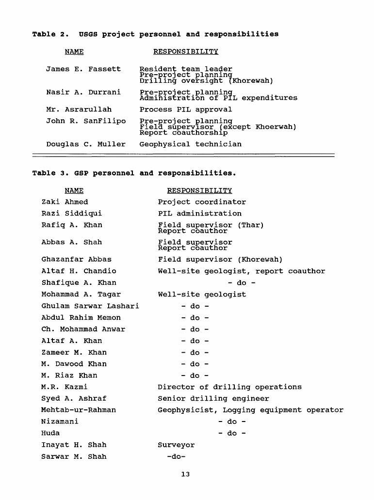
Table 2. US6S project personnel and responsibilities
NAME RESPONSIBILITY
James E. Fassett
Nasir A. Durrani
Mr. Asrarullah
John R. SanFilipo
Resident team leader Pre-project planning Drilling oversight (Khorewah)
Pre-project planning Administration of PIL expenditures
Process PIL approval
Pre-proj ect planningField supervisor (except Khoerwah)Report coauthorship
Douglas C. Muller Geophysical technician
Table 3. 6SP personnel and responsibilities.
NAME
Zaki Ahmed
Razi Siddigui
Rafiq A. Khan
Abbas A. Shah
Ghazanfar Abbas
Altaf H. Chandio
Shafigue A. Khan
Mohammad A. Tagar
Ghulam Sarwar Lashari
Abdul Rahim Memon
Ch. Mohammad Anwar
Altaf A. Khan
Zameer M. KhanM. Dawood Khan
M. Riaz Khan
M.R. Kazmi
Syed A. Ashraf
Mehtab-ur-Rahman
Nizamani
Huda
Inayat H. Shah
Sarwar M. Shah
RESPONSIBILITY
Project coordinator
PIL administration
Field supervisor (Thar) Report coauthorField supervisor Report coauthor
Field supervisor (Khorewah)
Well-site geologist, report coauthor- do -
Well-site geologist- do -
- do -
- do -
- do -
- do -
- do -
- do -
Director of drilling operations
Senior drilling engineer Geophysicist, Logging equipment operator
- do -
- do -
Surveyor -do-
13

were the responsibilty of Fassett and GSP. Day to day field
activities were supervised by SanFilipo, Rafiq A. Khan (through
April), and Abbas A. Shah, with the exception of the Khorewah
holes, which were supervised by Ghazanfar Abbas. Syed Ashraf
coordinated drilling logistics from Karachi, under the
supervision of M. R. Kazmi (Quetta). D.C. Muller spent about one
month during the JTB- and initial COALREAP drilling assist GSP in
setting up the geophysical logging units.
Drilling Summary
Location and access
The project area is located in southern Sindh Province,
Pakistan. The areas drilled include portions of the Thar Desert,
Lakhra, Sonda and Meting - Jhimpir coal fields, and adjacent
areas (fig. 1). Borehole locations are shown in figures 2-4.
The LS- series of boreholes were drilled in the in the
southern part of the Lakhra coal field, along the axial trace of
the Lakhra anticline (fig. 2), for the purpose of filling in the
data gap between the producing part of the Lakhra coal field and
the already densely drilled Sonda coal field (figs. 2 and 3). The
Lakhra south area is located within a few kilometers from
Hyderabad and is accessable by well-maintained dirt roads. The
rocky flats and isolated mesas that characterize the area make it
much more accessible than the more rugged northern part of the
Lakhra field, as well as offering less cover for potential dacoit
activity. However, much of the area is under military
reservation and requires permission for use.
As previously explained, the SO- series of boreholes were
14

H290 43'
LAKHRA COAL
FIELD
\-zy so'
J-23" IS 1
H29» 00
\-ZA* «3 r
METING-JHIMPIR COAL FIELD
SONDA COAL FIELD
EXPLANATION
o Previous COALREAP drill hote
New COALREAP drill hole (Jan-June 1992)
Village/City
1 Coal field
N
A
SEE FIG 3
FOR DETAILS
OF PREVIOUS
COALREAP DRILLING
WITHIN INSET
MAP AREA
.UAK-6 x - . o TandoUAK-70 Muhammad
oUAK-12 Khan
0UAK-8/
/ i i t
UAK-9
INDUS PLAIN
68' 30'
Urown Dy Foriimuddm
Figure 2. COALREAP borehole locations for the Lakhra, Sonda, and Meting-Jhimpir coal fields and adjacent areas. Coal-field boundaries are from SanFilipo (in prep) .
15

HYDERABAD
25-20'-
Baran Nadl ^
BolariEXPLANATION
O Prior Coal Reap/GSP drillhole
New COALREAP drill hole (Jan-June 1992 )
Village/City
Surfaced road
Railroad
Mulla ©Katiar
O UAK-I
Drawn by Fahimuddin
Figure 3. Detailed borehole location map, northern part of the Sonda coal field and vicinity.
16

9)O
«_ 0)-o £<u c
o.Xu
^ T5
o £ «1) _4J §
D D C
V!
O JC o p
o^°
oil
QZ
X*
I I£L o
X
-T' «'! ft.4 ?v a. ^5-__A '- **.
^--
o
HD
*
U.
O
z.
2
<
cc
Figure 4. Location of COALREAP boreholes drilled in the Thar Desert between February and July, 1992.
17

shallow holes testing Sohnari coals, which are generally much
thinner and deeper than the Bara Formation coals of the Lakhra-
Sonda coal fields. These holes were drilled along the outcrops
of Eocene rocks which extend northward and southward from the
producing Meting-Jhimpir coal field (fig 2). These areas are
characterized by rocky flats and isolated mesas similar in
character to the Lakhra south area, and they are generally easily
accessible from the National and Super Highways (fig. 2) by well-
maintained dirt tracks.
Boreholes KHW-1, KHW-2, and BN-1 were drilled within the
irrigated portions of the southern Indus Plain (fig. 2). This
area is densely populated and contains numerous well-maintained
roads. Although the last few hundred meters of approach to these
holes is difficult due to irrigation dikes, they are
otherwise easily accessible from metalled (paved) roads.
Although well-within the Indus plain, and over 30 km from the
nearest Indus River crossing, BN-1 is located within the Sonda
coal field as defined by Ahmed and others (1984).
The Thar Desert area is characterized by semi-stable sand
dunes typically up to 80 m high. North of Khokhropar (fig. 4)
the dune fields are dominated by northeast-southwest trending
seifs typically up to 25 km long; south of Khokhropar barchan
dunes several kilometers in length dominate. The interdune areas
are characterized by playas. The only metalled road in the
southern part of Thar extends from Naukot to Mithi (fig. 4). The
main dirt tracks are somewhat stabilized by heavy use, but four-
wheel drive is required for small-vehicle travel in the desert
and all-wheel drive is required for truck-mounted drilling rigs.
18

Public transportation in the desert is provided by surplus World
War II vintage U.S. army trucks. These vehicles can be hired
(rented) in the larger villages and can easily transport a skid
mounted drilling rig.
Data from the JTB- series drill holes are not included in this
report, but the borehole locations are shown in figs. 2 and 3 for
completeness. The results of the JTB- drilling are discussed in
John T. Boyd Co. (1992), and basic drilling data is available in
GSP files.
Drill-hole coordinates in the Survey of Pakistan metric
rectangular grid system are shown in table 4, along with collar
elevations in meters. Hole locations were surveyed by GSP
surveyors using a theodolite to triangulate from control points
for which the Survey of Pakistan publishes elevations and
relative horizontal distances. Hole coordinates were then
computed trigonometrically. The accuracy standards for this
level of survey are about +/-5 m horizontally and +/-1 m
vertically (Sarwar M. Shah Khan, Sr. Photogrammetrist, GSP, oral
communication, 1989), but the numbers in table 4 are recorded to
somewhat greater precision, exactly as provided by the surveyors.
It should be noted that the surveyed coordinates of some holes,
notably SO-3 and BN-1, vary slightly (a few hundred meters) from
the locations recorded on topographic sheets during drilling. It
is therefore advisable that the locations in table 4 be field
checked prior to any additional drilling in immediate areas.
Drilling operations
Drilling was done by GSP crews using GSP-owned equipment.
19
Table 4. Surveyed drill-hole coordinates and elevations,COALREAP drilling from February through July, 1992.Boreholes drilled under the supervision of the John T. Boyd Co. (JTB- holes) are not shown.
:LL HOLE
BN-l
KHW-1
KHW-2
LS-1
LS-2
LS-3
LS-4
SO-1
SO-2
SO-3
SO-4
SO-5
TP-1
TP-2
TP-3
TP-4
EASTING (meters)
2159103
2187089
2186838
2159165
2165211
2161903
2161393
2156334
2154581
2136513
2170344
2122510
2365892
2415787
2376377
2333256
NORTHING (meters)
810189
787206
787742
855380
861810
867513
875223
856676
850422
805516
875422
781534
802144
803082
781018
755653
GROUND ELEVATION (meters above MSL)
14.0
9.6
10.6
56.0
55.2
57.6
81.0
60.4
56.4
29.3
28.7
34.5
78.0
89.6
73.7
19.8
Survey of Pakistan rectangular grid system
20

Two Longyear-44 and one Longyear-38 skid-mounted drilling rigs
and two Acker WA III-C truck mounted rigs were employed. The
Acker rigs were purchased for GSP by USAID; the Longyear rigs
were upgraded by USAID. Drilling was by continuous wireline
coring or conventional rotary non-coring methods. For non-coring
intervals a tricone roller bit was generally used. Diamond HQ-
and NQ-size bits were used for cored intervals. Kwik Thik
bentonite and CMC polymer mud was the usual drilling medium,
occassionally supplemented by locally purchased additives or
Johnson Revert.
Drilling operations were generally conducted around-the-
clock in three eight hour shifts, although mid-day operations
were generally suspended after May due to extreme temperatures.
One senior drilling engineer and one drilling foreman supervised
the overall operation of each rig. Each shift was supervised by
a junior drilling engineer. A GSP geologist was normally present
during drilling operations. SanFilipo visited each site (except
TP-1) on an intermittent basis to observe the core and drilling
progress and to pick up coal samples for shipment to the U.S.,
but the day-to-day operations and lithological and geophysical
logging were conducted by GSP personnel.
USAID financed "operational" costs of the project. This
essentially equates to outlays for consumable drilling supplies;
these include petroleum-oil-lubricants (POL) and maintenance for
drilling machinery and ancillary vehicles, drilling fluids, mud-
pump fittings, cement, core boxes, and consumable "foreign
exchange" drilling supplies which must be purchased from abroad,
21

such as core barrels, bits, reaming shells, core lifters, casing
shoes and casing. For this project, USAID also financed salary
and daily living allowances for GSP personnel in the field.
USAID also funded "commodity-related services" incidental to
drilling consumables, such as rental of water tankers, pickup
trucks and other necessary vehicles not available from GSP, and
hire of local laborers for digging mud pits and access roads.
Drilling operations began with a Longyear-44 at TP-1 on
February 1, 1992. Other rigs were deployed to this project as
they were freed from operations at the JTB- holes in Sonda.
Operations with an Acker rig began at LS-1 on 19 Feb 92. The
difficulty in obtaining compressors to perform pumping tests at
the JTB- holes caused some delay in shifting the rigs. A
Longyear 44 began operations at LS-2 on March 1, and the second
Acker spudded LS-3 on 14 March. The Longyear 44 remained in Thar
for the life of the project and completed 3 holes. The second
Longyear 44 was shifted to Thar to complete TP-4 after several
attempts to deploy an Acker to the desert failed; the three-axel
Ackers do not have power to the front axel and were not able to
travel in the sand. After completion of the LS- holes, the
Ackers were deployed to drill shallow holes in order to keep them
busy for the life of the project.
The Khorewah holes were originally intended to be part of a
GSP drilling program distinct from COALREAP. Because GSP could
not finance the holes, the USGS Resident Team Leader agreed to
include these holes in COALREAP PIL and assume responsibility for
their supervision. A Longyear 38 was deployed from Lahore and
began drilling KHW-1 on March 7, which was drilled just outside
22

of a fenced gas well that had reported a very thick and shallow
coal bed. The first coal intercepted in KHW-1 was much deeper
and thinner than that reported in the gas well, so a second hole
was drilled less than 1 km from the first, more-or-less on the
opposite side of the gas well. When it became clear that both
holes were nearly barren, the operation shifted to the Sonda coal
field to drill BN-1 under the supervision of SanFilipo. Although
not considered a high-priority hole, BN-1 was included in the
drilling program because it was the only remaining hole necessary
to complete USGS recommended drilling in the Sonda coal field,
and was very easily accessible by the rig already deployed in
Khorewah.
Drilling operations were scheduled to break for the observence
of Eid-ul-Fitr during the last week of March through the first
week of April. LS-1 and LS-2 were completed on March 11 and
March 17 respectively. It was originally intended that these
rigs would shift to northwest Lakhra and set casing before the
holiday break, but those plans were abandoned due to the security
situation. In order to keep the rigs operating, two unplanned
shallow Sohnari tests, SO-1 and SO-2, were drilled in lieu of
beginning holes in northwest Lakhra that would be too deep to
complete before the break (unfortunately the rig at SO-1 broke
down and the hole had to be reentered after the Eid break). The
plans to drill north of LS-4 were eventually abandoned altogether
due to the security situation (specifically a kidnapping and
shootout at one of the operating mines in northwest Lakhra and an
armed attack on a USGS field party traveling some 50 km north of
23

the intended drilling area).
Boreholes LS-3 and LS-4 are located within the Kotri Firing
Range, which is permanently occuppied by a few personnel of the
Pakistan Army for small-arms practice, but is also the site of
periodic heavy artillery and tank maneuvers. LS-3 and LS-4 were
located on the axial trace of the Lakhra anticline in order to
keep drilling depths to a minimum. A misunderstanding between
the Army, the USGS supervisor, and the drilling crews resulted in
the necessity to suspend drilling at LS-4 from April 26 to May 21
during live-round tank maneuvers. The rig was shifted to drill
SO-4 during this period. LS-4 was reentered on May 21 but
abandoned 164 m short of the target depth on June 3 for the Eid-
ul-Azha celebration. Plans may have been made by GSP to reenter
the hole and remove stuck casing and rods and possibly complete
the hole to total depth after the formal completion of this
project. Drilling at TP-4 also broke for Bid in early June, but
was reentered and completed in early July.
Despite the usual presence of eight or ten armed guards at the
drill camps, and armed escorts traveling with most vehicles, a
number of security incidents worth noting took place. In
particular, a rented pickup truck occuppied by three GSP
personnel was hijacked by persons armed with automatic weapons
while enroute to JTB-4, and a number of firing incidents took
place at various drill sites, notably LS-2. In addition to this,
several GSP vehicles were confiscated by the Army during the
quasi-martial law that was declared in Sindh towards the end of
the drilling program. All of these factors, along with the
problems at LS-4 and several "strikes" by GSP drivers and
24

drilling crews, extended the drilling project well beyond its
anticipated timeframe.
Drilling statistics including depths and core recovery are
shown in table 5. With the exception of KHW-1 and KHW-2,
SanFilipo had the responsibilty of picking the initial core point
and the total depths for this drilling project. Past experience
with drilling conditions in Sindh has proven that for this type
of diamond drilling, the real costs of coring hardly exceed those
of noncoring (see SanFilipo and others, 1989). For this reason,
holes spudding in bedrock were cored from at or very near the top
of the hole for this phase of drilling. In the Thar Desert, the
drillers were instructed to begin coring at 55 m or the first
occurrence of bedrock, whichever came sooner, or before that, at
the discretion of the driller.
Because the main purpose of the LS- series boreholes was to
establish a coal-bed correlation scheme between the Lakhra and
Sonda fields, it was imperative that these holes penetrate both
the "lower" and "upper" coal zones of SanFilipo and others
(1988) . These holes are therefore relatively deep, with the
exception of LS-4 which was abandoned before reaching the target
depth of 400 m. The general target depth in the TP- holes was to
penetrate at least 30 m of the thick sand that underlies the main
coal zone in SAZDA TH-5 (SanFilipo and others, 1992). This
target was met at TP-1, which twinned SAZDA TH-5, and probably
met at TP-4, but TP-2 was barren and unexpectedly bottomed in
granite, and TP-3 intercepted granite just below the coal. The
target depth of the SO- holes was to penetrate a few meters of
25
Table 5. Drilling statistics
Drill Total Non-core ]--- Hole Depth drilling HQ
(m) (m) (m)
Core drilling ---------| |----.
NQ Total Cumulative HQ(m) (m) total (m) (m)
Core recovered --------| |- Percent core recovery -|NQ Total Cumulative HQ NQ Total Cumulative(m) (m) total (m) total
BN-1 213.96 25.90 188.06 ----- 188.06 188.06
KWH-1 137.31 3.35 101.93 32.03 133.96 322.02
KWH-2 230.73 1.82 138.38 90.53 228.91 550.93
LS-1 402.64 7.39 234.49 160.76 395.25 946.18
LS-2 372.49 6.10 366.39 ----- 366.39 1312.57
LS-3 352.37 6.10 346.27 ----- 346.27 1658.84
LS-4 236.50 ---- 236.50 ----- 236.50 1895.34
SO-1 108.38 2.13 106.25 ----- 106.25 2001.59
SO-2 160.18 6.10 154.71 ----- 154.71 2156.30
SO-3 124.15 2.87 121.28 ----- 121.28 2277.58
SO-4 123.54 9.14 114.40 ----- 114.40 2391.98
SO-5 132.76 1.70 131.06 ----- 131.06 2523.04
TP-1 253.13 54.86 198.27 ----- 198.27 2721.31
TP-2 196.42 54.86 141.56 ----- 141.56 2862.87
TP-3 209.57 22.70 186.87 ----- 186.87 3049.74
TP-4 252.60 12.32 240.28 ----- 240.28 3290.02
108.29 ----- 108.29 108.29 58 -- 58
27.29 12.94 40.23 148.52 27 40 30
50.72 17.65 68.37 216.89 37 19 30
213.78 109.68 323.46 540.35 91 68 82
322.19 ----- 322.19 862.54 88 -- 88
256.01 ----- 256.01 1118.55 74 -- 74
177.46 ----- 177.46 1296.01 75-75
102.02 ----- 102.28 1398.03 96 -- 96
152.58 ----- 152.58 1550.61 99 -- 99
109.08 ----- 109.08 1659.69 90 -- 90
112.23 ----- 112.23 1771.92 98 -- 98
124.13 ----- 124.13 1896.05 95 -- 95
147.66 ----- 147.66 2043.71 74 -- 74
108.41 ----- 108.41 2152.12 77-77
124.70 ----- 124.70 2276.82 67 -- 67
165.00 ----- 165.00 2441.82 69 -- 69
Total 3507.36 217.34 3007.70 283.32 3290.02 3290.02 2301.55 140.27 2441.82 2441.82 77 50 74
58
46
39
57
66
67
68
70
72
73
74
75
75
75
75
74
74
intermittent intervals after the first core point were not cored - see individual drill hole logs
26

the D limestone of the Lakhra Formation (Ahmed and others, 1984a,
SanFilipo and others, 1994); the drilling depth required to do
this was deeper than anticipated at each of the SO- series holes.
BN-1 was terminated at the occurrence of the non coal-bearing
middle Bara facies (see SanFilipo and others (1994, p. 33), which
occurred much shallower than anticipated.
Fassett and Gazanfar Abbas were responsible for drilling
oversight at KWH-1 and KWH-2. KHW-1 was located about 500 m from
a gas well where several coal beds had been reported in the mud
log (Appendix 1) to occur at depths as shallow as 11 m, including
a 20 m thick coal bed at 33 m depth. The decision to stop
drilling at KWH-1 was made after no such bed was intercepted by
100 m depth, but drilling continued to 137 m while waiting for
the geophysical logger to arrive on site. The rig was shifted to
a site selected by Fassett about 600 m northwest of KHW-1, just
outside the gas-well fence, and another hole (KWH-2) was drilled.
When the main gear box broke at 186 m, just prior to the Bid
break, and the hole was essentially barren, SanFilipo ordered the
hole geophysically logged, with the hopes of freeing up the rig
to speed up the Thar drilling. After the Bid break, however,
KWH-2 was reentered on the decision of higher authorities.
The preferred core size for COALREAP drilling is HQ (63.5 mm).
HQ is preferred because: 1) core recovery tends to be better than
with smaller diameters, 2) enough material is available with HQ
to sample each coal bed 30 cm or greater in thickness and obtain
all the necessary splits, 3) the most important geophysical tools
can easily pass through HQ rods, which permits unstable holes to
be logged before collapsing. It has, however, been necessary for
27

some COALREAP drilling to reduce to NQ (47.6 mm) or smaller size,
due to adverse drilling conditions such as friable sandstone.
The need to maintain HQ size has been exacerbated by the
introduction of digital geophysical equipment for this phase of
COALREAP drilling. The digital tools are of slightly larger
diameter than the analog tools previously used, and can more
easily hang up in the NQ drill string. With the exception of LS-
1, which was reduced well before TD without prior notification to
USGS, HQ was generally maintained for this project.
Drilling statisitcs
Sixteen holes ranging in depth from 108 to 403 m and totaling
3507 m were drilled in this phase of COALREAP (table 5, figures
exclude 4 holes totaling 855 drilled under supervision of J.T.
Boyd Co.). About 94 percent was cored, and HQ was maintained for
92 percent of the core drilling. More detailed drilling
statistics, including cased intervals and drilling records for
each borehole, are included in Part II.
The cumulative recovery in cored intervals was about 74
percent for this phase of drilling, which is slightly better than
most of the prior phases of COALREAP drilling (see SanFilipo and
others, 1988, 1994). Core recovery in individual holes ranged
from 30 percent to 99 percent. The overall core recovery was
much poorer than average in the deeply alluviated Khorewah and
Bano holes and much better than average in the very shallow
Sohnari holes. Except for the Khorewah holes, the core recovery
in coal beds was also very good. Most of the core loss appears
28

to have occurred in thick-bedded, friable sandstone intervals,
which is typical when coring the upper Paleocene series of Sindh.
Reconciliation of core-loss intervals with geophysical logs,
particularly for coal beds, will be included in subsequent
reports, subject to the availability of funds.
Data collection
Rock sampling and descriptions
Two or three GSP geologists were generally assigned to each
drill hole. Shifts were scheduled so that at least one geologist
would be present during drilling, but logistical problems,
notably at TP-1, resulted in some core (including coal) being
pulled with no geologist present. The geologist was responsible
for insuring that the drillers maintained proper records of
drilling depth, collected samples of cuttings at regular
intervals during non-core drilling, and properly extracted core
from core barrels. Cuttings were usually sampled at 1.52 m (5-
foot) intervals. After describing the cuttings, the geologist
bagged and labeled a small sample for retention. Core was
extracted from the inner core barrel onto a wooden core trough by
means of hammering or mud pressure. The mud cake was washed off
and the core was described by the geologist. Core was boxed in
standard sized wooden boxes and properly labeled by the
geologists. The core is currently stored in the GSP core library
at Sonda village.
Rock descriptions are included in Part II. The position and
presumed lithology of core loss intervals in Part II are as
estimated by the geologist at the well site; both are subject to
29

reinterpretation after reconciliation with geophysical logs, and
may be revised in subsequent reports.
Coal sampling methods
A list of coal intercepts and field sample numbers is included
in Appendix 2. Additional information is provided by the sample
forms recorded in the field and provided in Part II. Except as
noted, all coal beds 30 cm thick or greater were evenly split by
chisel in the field so that samples could be submitted to both
USGS and GSP laboratories. Thinner beds were sampled for GSP
labs at the site geologist's discretion. Individual coal beds
were divided into smaller sample benches at the discretion of the
site geologist, depending on the homogeneity and thickness of the
coal.
If coal was intercepted during daylight hours, it was
immediatly described, bagged and labeled. If coal was cut at
night and could not be described by artificial light, it was
placed in polyethelene or styrene sleeves and wrapped in wet
cloth, or temporarily sealed in PVC pipe until it could be
described and sampled in daylight. After description, coal
samples were double or triple bagged in plastic, to preserve
moisture, and labeled. Immediately after bagging, all samples
were placed in air-tight plastic barrels, which were trucked to
Karachi after being filled. GSP samples were submitted for
grinding and proximate analysis at GSP laboratories in Karachi.
The barrels containing USGS samples were shipped to the USGS
headquarters in Reston VA by air. Upon arrival in Reston, the
barrels were opened and the samples were examined and sent to a
30

contractor lab (Geochemical Testing, Somerset PA) for grinding
and a standard coal analysis package (proximate, ultimate,
heating value, sulfur forms, equilbibrium moisture, hardgrove
grindability, ash fusion temperature and apparent specific
gravity). If sufficient sample is available, the contractor
returned splits for trace element analysis, petrography, and back
up, in the that order of priority. The results of analysis will
be presented in future reports.
A sampling problem occurred when only one GSP geologist was
assigned to TP-1 and he had to leave the site to get core boxes
(normally the responsibility of the drilling crew, and a two-day
trip due to the remoteness of the site). Despite the first coal
occurrence being within 1 meter of the depth predicted in the
predrill report, the coal was apparently boxed for several days
before description and sampling, and appears to have dried
substantially. There were no barrels available at the site, so
the core was wrapped in plastic and shipped to Hyderabad in PVC
pipe. Because the coal was oriented, SanFilipo split most of the
TP-1 core in Hyderabad and shipped the GSP split to the recently
installed petrographic laboratory in Islamabad. The TP-1 splits
sent to Islamabad are noted in Appendix 2. Because of the
importance of the major coal discovery at Thar, two GSP splits
(TP-1-1 and TP-1-2) and one USGS split (TP-1-5A2) were sent for
proximate and standard coal analysis respectively immediately
after drilling. Sample TP-1-7, which was described as "dirty
coal" and not sampled at the well site, was sampled by SanFilipo
at the Sonda core library approximately one month after drilling.
Rather than having a high ash content as initially described in
31

the field, this sample comes from the top of the main coal bed
and appears to possibly be weathered or less mature than the
underlying coal, and very much resembles the light-brown coal
described for borehole ODA-2 in SanFilipo and others (1992).
The remainder of the oriented TP-1 core was X-radiographed in
Reston and benched into microfacies before submittal for the
standard coal analysis package. A list of the samples benched by
microfacies appears in Appendix 2. These will hopefully be the
subject of future petrographic study by USGS. It is assumed that
the samples sent to the GSP petrographic laboratory will be
resplit and also submitted for proximate analysis at the GSP
Karachi laboratory (the purpose of duplicate analysis by USGS and
GSP is to calibrate the GSP lab; although this has been attempted
several times, the GSP facility has recently moved, and steps to
standardize the lab are still necessary). In any case, the
ground backup split of the benches that were not submitted to GSP
are being retained for eventual GSP analysis.
Due to COALREAP budget restrictions, only 40 of the 92 samples
submitted to USGS contractor labs for standard analysis have thus
far been submitted for trace element and oxide analysis. These
samples are noted in Appendix 2; they include most of the main
Thar coal bed at TP-3, and probable bifurcations of the same bed
at TP-4. The Thar samples were chosen over samples from the
other areas because of their special significance; they represent
a major new coal discovery, which is by far the largest in
Pakistan to date, and which, unlike the other coal fields of
Sindh, has not previously been studied for trace elements (see
32

Landis and others, 1988, and Finkleman and others, 1994). We
chose to spread the sample selection between TP-3 and TP-4 in
order to best represent the Thar coal, both vertically and
laterally, within the budget constraint of 40 samples. With that
in mind, we attempted to chose samples with a wide range of ash
yields, which has been shown by Finkleman and others (1994) to be
strongly correlated with trace element concentrations for the
Sonda coal field, and to eliminate thinner samples (many of which
were desorption samples). We chose this sampling scheme rather
than combining samples to represent all four TP- holes in order
to maintain correlation with the samples submitted for standard
analysis. Trace element splits for the remaining samples have
been retained for future analysis if needed.
Gas desorption testing
Coal-bed methane is currently being produced in commercial
quantities from several basins in the United States. Although
the stored gas content for such areas generally increases with
the rank of the coal and its depth below the water table (Close
and Erwin, 1989), some commercial gas is being produced in the
Powder River Basin from low-rank coals that are associated with
compaction structures situated well-above the regional water
table (Law and others, 1991).
Despite the thermal immaturity of Sindh coals and their
general proximity to the water table, a directive to include
coal-bed desorption measurements in this phase of drilling was
issued by the USGS Resident Team Leader. Measuring coal-gas
desorption potential at the drill-site is a very time consuming
33

process that requires specialized equipment. The procedure
consists of placing an unsplit core of about 30 cm length in a
sealed cannister and measuring the volume of water displaced by
escaping methane at periodic intervals. Because most of the
coal-bed gas is desorbed shortly after exposure to atmospheric
pressure, extreme care must be taken to record the time interval
between coal bed penetration and direct gas measurements. To
estimate the gas yield, the measured volume of gas desorbed is
converted to STP and plotted versus time, and the results
extrapolated back to the time of coal bed penetration to make up
for "lost gas". These procedures are outlined in detail in
Barker (1991), McCulloch and Diamond (1976), and Close and Erwin
(1989) .
We tested eight samples for desorption potential. The results
of the tests are shown in table 6. As expected, the gas yield
was small. For most of the samples tested there was insufficient
gas generated to make reliable calculations of lost gas. On an
empirical basis, the cummulative gas yields of the samples we
tested are about two orders of magnitude less than typical
commercial wells (see Close and Erwin, 1989), and more than one
order of magnitude less than typical desorbtion measurements from
the Powder River Basin (see Barker, 1991). We have therefore
just presented the raw data in table 6; no conversions to STP,
estimates of lost gas, or gas yields per unit mass have been
included.
Because of the care that must be taken to handle the samples
very quickly, measuring the desorption at the drill site is labor
intensive. Given the shortage of GSP geologists available for
34

Table 6. Results of gas desorption tests. Pressure and temperature are the ambient conditions recorded at the drillsite. Time of +1 indicates next day reading. x Coal intercepted' refers to the time that the top of the coal bed was penetrated. 'Sample top intercepted' refers to the approximate time that the top of the desorption sample was intercepted for beds that were not penetrated in a single run. 'Fishing begins' refers to the time when the core run has been completed and the wireline assembly is latched to the imertube for retrieval from the core barrel through the drill string. No attempt to compute gas lost during drilling and sampling was made for this report. Samples were not weighed; weight of sample can be determined from the sample thickness and core diameter of 63.5 mm, assuming an average specific gravity of 1.30 g/cc. Note that LS-4-1, LS-4-2B, TP-3-2B and TP-3-2X were subsampled for desorption (cannister length = 30cm), but not for other analyses (Appendix 2).
Sample number
LS-4-1
(depth: 173.03 m)
(thick: 0.30 m)
LS-4-2A
(depth: 190.98 m)
(thick: 0.30 m)
LS-4-2B
(depth: 191.68 m)
(thick: 0.30 m)
TP-3-2B2
(depth: 147.44 m)
(thick: 0.30 m)
Time[hours)
0300...04350445..0455 , . ,0500051005200530060007000900
103511451205 ,1212121512251235124516301245+1
103511451205...,1212122012301240125016351255+1
09561140....12101214??
1226..12361246
Pressure Temp Gas vol. /(mm Hg) C (cc) /
.......(coal intercepted 3 172.96) /
..... ..(fishing begins) /
.......(core reaches surface) /
.......(coal removed from innertube) /
.......(coal sealed in canister) /998 28 35 /998 28 5 /998 28 few bubbles /998 29 few bubbles /1000 32 few bubbles /1001 36 few bubbles /
.......(coal intercepted a 190.98) /
.......(fishing begins) /
....... (core reaches surface) /
.......(coal removed from innertube) /
.......(coal sealed in canister) /1001.5 41 35 /1001.5 42 5 /1001.5 42 few bubbles /1000.0 40 2 /1000.5 43 nil /
//
.......(coal intercepted a 190.98) /
..... ..(fishing begins) /
.......(coal removed from innertube) /
.......(coal sealed in canister) /1001.5 41 25 /1001.5 42 5 /1001.5 42 few bubbles /1000.0 40 1 /1000.5 43 nil /
//
.......(core run began) /
.......(coal intercepted a 145.96) /
.......(fishing begins) /
....... (core reaches surface) /, ......(coal removed from innertube) /,......(coal sealed in canister) /
743 41.5 15 /nil /
//
//
Samplenumber
TP-3-2D
(depth:148.64 m)
(thick:0.22 m)
TP-3-2K1
(depth :153.92 m)
(thick:0.30 m)
TP-3-2Xa
(depth:165.52 m)
(thick:0.29 m)
TP-3-2Xb
(depth:165.81m)
(thick:0.30 m)
Gas vol.
1215............(core run began)1245............(sample top intercepted)1425............(fishing begins)1430............(core reaches surface)?? ............(coal removed from innertube)1445............(coal sealed in canister)14551506152115361608162316521800193821562245
739
739
738
42.5
43.0
42.5
34 nil15
nil25
nil nil13
nil nil nil
1630............(core run began)1630............(sample intercepted)1836............(fishing begins)1842............(core reaches surface)?? ............(coal removed from innertube)1854............(coal sealed in canister)1944 741 37 35 2013 - - nil 2156 - - nil 2245 - - nil 2343 - - nil
2235............(core run began)2325............(sample top intercepted)2345............(fishing begins)0005+1..........(core reaches surface)?? ............(coal removed from innertube)
0016............(coal sealed in canister)0030 - - nil 0110 - - nil 0134 - - nil 0537 - - nil 1625 741 41 100 2100 746 33 nil
2235............(core run began)2325............(sample top intercepted)2345............(fishing begins)0005+1..........(core reaches surface)?? ............(coal removed from innertube)0012............(coal sealed in canister)002601100149053716152050
746
741746
30.5
4133
1nil nil nil 80
nil
35

well-site activities for this project, their diversion from more
important well-site functions was probably ill-advised for this
phase of the project. The study and in-situ measurement of
coalbed methane is at best imprecise however, particularly for
low-rank coals, and additional gas desorbtion measurements of
Sindh coals under more rigorously controlled conditions are
probably warranted. In particular, if the thick coal at Thar
extends to the deeper subsurface towards the Indus Basin to the
west, the coal-bed methane potential could be considerable, and
additional investigations are warranted. This will be discussed
further in the section Preliminary conclusions and
recommendations.
Geophysical logging
Geophysical logs for each drill hole are included in Part II.
All logging for this project was done using GSP unit MT-2, which
is one of two identical Mount Sopris digital logging units
mounted in Ford panel vans and purchased for GSP by USAID. The
other unit (MT-1) was theoretically available for the project,
but was never fully operational during this phase of drilling.
Downhole tools from MT-2 were occasionally cannabilized to keep
MT-1 operating during the project. Prior to this phase of
COALREAP drilling, these units had only been operated in a few
shallow holes for the purposes of training operators and
calibrating the equipment. Previous COALREAP drilling was logged
using older, but generally more reliable, analog equipment.
Normal operation with MT-1 and MT-2 usually consists of
several passes (e.g. first through drill pipe and then in an open
36

hole) with each two modular probes. The first probe (JLP )
consists of natural gamma, neutron, spontaneous potential (SP),
single-point resistivity, and short-normal (40") resistivity.
The SP and resistivity tools were not operational during this
project. The second probe (XAP ) consists of gamma-gamma-near
density (GGFR - more or less equivalent to 4-pi density), natural
density (GGNR - more or less equivalent to high resolution
density of the analog recorders used previously), gamma-gamma-far
gamma, single-arm caliper, and guard (focused) resistivity. The
guard log did not properly function during this project, and
generally was not run.
A USGS logging technician was sent to Pakistan during the
early parts of the JTB- and TP- drilling to try and get both
units fully functional, but he was unsuccessful. In addition to
the problems with the resistivity and SP probes, a number of
other logging problems plagued the project, notably the
reluctance of the operators to run the tools through pipe, and
the lack of spare parts available for the vans, which were
involved in several road accidents, most likely due in part to
their left-hand drive (i.e. nonstandard for Pakistan) and lack of
side windows. Mitigation of logging problems required an
inordinate amount of time and attention by the field supervisors.
Because of the instability typical of holes drilled in the
soft coal-bearing strata of Sindh Province, the normal COALREAP
logging procedure is to run both tools through the drill rods as
*XAP and JLP are manufacturers designations for these probes and are
alphabetized mnemonic devices with no intrinsic meaning (i.e. not acronyms)
37

soon as total depth is reached. Depending on the position of the
coal, the rods and/or casing are then partially pulled back and
logs are run below the pipe in the open part of the hole. This
is especially important for getting a useful caliper log in the
coal intervals (which obviously can't be obtained through the
pipe), because once the casing is pulled (even surface casing),
the holes tend to collapse. The caliper log is essential to
distinguish coal from caved intervals, which are very frequent in
these holes. If the hole is clear to a useful depth when the
casing is completely pulled, a final logging pass is made in the
open hole.
A list of the geophysical logs provided in Part II is shown
in table 7. Because GSP was able to maintain HQ size without
reduction for most of this drilling phase, most of the holes did
not require deep casing, and only two passes with each probe were
run. For some very shallow holes (e.g. SO-1, table 7), only the
open-hole log was run. Additional information on the condition
of the holes and the casing and mud used is provided on the
geophysical log headers and the cover sheets of the lithological
logs in Part II. Specific logs mentioned in the text that
follows will be referred to by their identification number in
brackets, and the type of log will generally be referred to by
the abbreviation shown on the digital header to each log (i.e.
JOH for JLP open-hole, JDP for JLP through drill pipe, XOH for
XAP open-hole, XDP or XADP for XAP through pipe, etc.)
The only significant problem from not running supplementary
logs with the casing partially pulled back arose in a three-meter
interval of core loss and coal at 78 m depth in KWH-1. Based on
38

Table 7. List of geophysical logs. Each letter indicates asingle log included in Part II, numbered as shown in brackets.
Borehole
BN-1
KHW-1
KHW-2
LS-1
LS-2
LS-3
LS-4
SO-1
SO-2
SO-3
SO-4
SO-5
TP-1
TP-2
TP-3
TP-4
JLP Probe type-
C[5]
C[7],c[8]
R[14],o[15]
R[18],0[19]
R[22]
0[24]
R[26] ,O[27]
R[30],0[31]
0[34]
R[36],o[37]
o[40]
R[43] ,O[44]
r[47],o[48]
R[51]
XAP
R[3],0[4]
C[6]
C[9] f c[10]
C[12],RC[13] (from 158 m)
R[16],o[17]
R[20],O[21]
R[23]
0[25]
R[28],O[29]
R[32],O[33]
0[35]
R[38],o[39]
r[41],o[42]
R[45],O[46]
r[49],o[50]
R[52]
Explanation:
R r = through rodsC c = through casingRC re = through rods and casingO o = open hole (+surface casing)
Upper case indicates approx to TD Lower case logged short of TD
for most cases:
XAP high-resolution den 4-pi density (GGFR) natural gamma caliper (open hole)
jLp natural gamma neutron
39

the XDP density logs [6], the entire interval could be either
coal, or, a wash-out. SanFilipo's suggestion of only pulling the
casing back to 76 m for the first pass of open-hole logging was
ignored by the USGS and GSP Khorewah supervisors, and the hole
collapsed before a caliper log could be run. The coal bed in
question was not present in KWH-2, less than 600 m to the
northwest.
Other problems that arose included the XAP probe getting
stuck in NQ rods at 158 m at LS-1, forcing the cable to be cut to
retrieve the tool [13]. Although both probes easily pass through
NQ rods at the surface, GSP declined to log through NQ after that
incident for fear of foreign material dropping in the annulus
and jamming the probe in the drill stem. This did not cause
any major deficiencies in the suite of logs obtained for this
project, but it did exacerbate the importance of not reducing
the hole size, which may have slowed drilling progress a bit.
A similar problem arose because of the reluctance of the
operator to open the caliper through drill pipe. The GGNR is a
sidewall log; without the caliper open the tool swings
periodically in the hole, which causes a recording anomaly at
regular intervals. This can be easily observed on the LS-1 XOH
log [12] above 184 m, where the caliper was partially retracted.
It is also possible that the digital logs are showing some casing
effects at pipe joints; this will be investigated in future
interpretive reports.
Despite a depth shift for the gamma trace on the XAPD log
[13] which was stuck at 158 m in LS-1, the log is included in
Part II because it shows useful information; in particular it
40

illustrates the difference between the pendulum effect described
in the previous paragraph and some of the other anomalous signals
(e.g. 195 and 198.4 m on the XOH log [12]) that mimic true coal
signatures (e.g. the XAPD log [13] at 201.8 m on the GGNR/GGFR
and 205 m on the shifted gamma).
Because of the instability of the hole, TP-3 was logged
through the major coal before the hole was completed. After
pulling the rods for open-hole logging, the hole partially
collapsed. It was redrilled and deepened, but did not intercept
much coal below the main bed and was not relogged in order to
avoid risking unnecessary desert travel by the sole operating
logging unit. Because of access problems, TP-1 was also not
logged to TD; the loggers did not reach the hole until several
days after completion, and the bottom of the hole collapsed after
the drillers pulled the rods back to prevent sticking during the
wait. The neutron probe was also not functioning on the JLPO
probe at TP-1 [40]. In general subjective terms, the digital JLP
log does not seem as useful for hole-to-hole correlations as the
older analog gamma-neutron logs used in prior COALREAP drilling,
which is their most important purpose for this type of drilling.
The single-arm caliper is also not nearly as effective as the 3-
arm caliper used previously, which is obviously of major
importance in this type of operation.
Although the COALREAP program has formally ended, detailed
geophysical log interpretation for all the boreholes included in
this report will hopefully be included in subsequent work. At a
minimum this should include using the geophysical logs to
41

reconcile the coal intercepts shown in Appendix 2 with the core
loss recorded at the drill sites, and correlation of the LS-
series boreholes between the Lakhra and Sonda coal fields, which
was their primary purpose.
Preliminary conclusions and recommendations
South Lakhra
Based on four widely spaced boreholes, it appears that the
southern part of the Lakhra coal field (arbitrarily defined as
the area north of Baran Nadi and east of the Indus River on
figure 2) contains only thin coal beds which are relatively deep.
Although obvious from the topography and surface geology that the
coal in the Lakhra south area would be somewhat deeper than in
the area of the Lakhra field presently being mined (north of
borehole UAL-15, fig 2; see SanFilipo and others, 1988), the
degree of deeping is greater than was anticipated. While the
precise stratigraphic contacts are yet to be determined, initial
indications from the drilling are that the Lakhra Formation,
which overlies the coal-bearing Bara Formation, probably thickens
depositionally in this general area. The apparent depositional
thickening would account for the greater depth to coal than
anticipated, and might account for the thinning of the coal if
occurring as the result of a lateral facies change at the expense
of the Bara Formation.
Part of the rationale for drilling the south Lakhra holes
was that earlier COALREAP drilling in the Sonda field had
indicated that the Lakhra Formation was generally much thinner
than originally reported by Nutall (1932) or Cheema (1977), who
42

proposed that the unit thinned abruptly from the Sonda area to
the Lakhra area due to pre-Sohnari erosion. Although the
alternative possibility that the Lakhra Formation locally
thickened in south Lakhra was discussed in SanFilipo and others
(1988 p. 28 - 30), the apparent degree of thickening at LS-3 and
LS-4 is greater than was anticipated. The unit as a whole still
does not appear to be as thick in south Lakhra as was first
reported, but the cores and electric logs need to be studied in
more detail and correlated with the earlier drilling in the
Lakhra and Sonda fields to determine the precise stratigraphic
relationships. However, given the inability to complete the
Lakhra drilling program as planned, and the incomplete
geophysical records from the holes that were drilled, it may
still be difficult to establish a reliable correlation scheme
between Lakhra and Sonda from existing data. Two additional
boreholes in south Lakhra were drilled by GSP for the Pakistan
Mineral Development Corporation several years ago, but we were
unable to locate any records from these holes. The search for
these records, and the core itself (which may be stored at Sindh
Univ. at Jamshoro) should continue, and the information should be
integrated into future GSP studies.
Sohnari areas
Preliminary indications are that the Sohnari strata are more
variable in thickness and lithology than previously indicated,
and have less coal potential than was hoped for (SanFilipo and
others, 1988, Wnuk and others, 1991). It was particularly
disappointing that SO-1 was barren, because this hole is only a
43

few kilometers south of a quarry that exposes a well-developed
unit in the Sohnari (unit 17 of measured section LS-1, Wnuk and
others, 1991, p. 46) that is similar to local underclays. It
should be noted that the "underclay" is absent in SO-1; a
superjacent coal could occur in other areas of the subsurface
where the unit may be present, but in any case would probably
not be extensive. Boreholes LS-1 and LS-2 also penetrated the
Sohnari in the same general area as SO-1. LS-2 was located near
Mehran University, where an engineering test hole drilled in 1986
reported coaly material (Appendix 1). A relatively thick
carbonaceous Sohnari interval was recorded at LS-2, but Sohnari
coal was not present. Borehole SO-3 did confirm that the "Hilaia
(Chilia) beds", which have been variously placed in the
underlying Lakhra Formation (Nutall, 1932), or the Sohnari
(SanFilipo and others, 1988), are in fact coal-bearing, as was
first indicated in COALREAP borehole UAJ-1, drilled in 1986.
Preliminary field investigations downdip from SO-3 indicate that
the area is probably down-faulted to the west. While the
potential for Sohnari coal occurrence may increase to the west if
the Chilia beds thicken or if the carbonates lying between the
Chilia beds and the Sohnari proper pinch out, so will its depth.
Additional Sohnari coal drilling is not recommended at this time,
although the SAZDA water well drilling in the area should be
closely monitored. In addition to this, the Government of Sindh
should consider lifting the current moratorium on leasing in the
Sonda coal field or modifying it apply to the Bara Formation
only, because in its current form it is preventing Sohnari
exploration by the private sector (Shahid Ali Beg, General
44

Manager National Mines, oral commun., 1992), which was not its
original intent when imposed at the request of the COALREAP
cooperators in 1986.
Indus Plain
Initial indications from oil and gas records (Appendix 1:
Union Texas Khorewah-1) that a very thick and very shallow coal
deposit exists in the Khorewah area are obviously in error. The
general hypothesis that shallow coal deposits overlying fault
blocks might occur in this area (Jim Fassett, oral commun., 1992)
is also somewhat dubious, because most of the block-faulting in
the southern Indus Basin is pre-Tertiary (see Hardy in Raza and
Sheikh, 1988). While some of these faults were undoubtably
reactivated during Indo-Asian plate collision, it is extremely
unlikely that soft Bara sediments could have been preserved
through modern Indus erosion over these types of structures. The
depth to bedrock was over 75 m in both in KWH-1 and KWH-2, as
should have been easily predicted from previous COALREAP drilling
in the Indus Plain and by an informed examination of the Union
Texas mudlog, primarily from the abundance of mica in the upper
part of the hole, which is characteristically absent in the Bara
Formation but ubiquitous in modern Indus sediments. The cuttings
for this gas well, which are stored in the GSP core library in
Quetta, were examined by GSP after KWH-2 was drilled, and no coal
was evident in the upper part of the hole (Ghazanfar Abbas, oral
commun., 1992). While it appears that a moderately thick coal
bed may subcrops just below alluvium at 78 m depth in KWH-1, this
by no means certain because the most of the core was not
45

recovered, the interval was not properly logged geophysically,
and the bed is absent 600 m away at KWH-2. In any case, the
presence of coal at that thickness and depth could probably be
expected from simple structural projections of the Bara Formation
from the Sonda coal field, and is by no means extraordinary.
Reports that prior to the Thar discovery this was the "shallowest
discovery of coal of this thickness in Sindh" (memorandum from
Fassett to S.A. Hassan, USAID, March 24, 1992) are erroneous
(shallower coal of comparable thickness is presently being mined
from numerous locations in the Lakhra coal field, see SanFilipo
and others, 1988). It should also be noted that this
hypothetical coal deposit has been erroneously referred to in the
literature as the Badin coal field and has had an equally
erroneous preliminary resource estimate of 8 billion tonnes made
on the basis of the Union Texas hole (Kazmi and others, 1990,
Thomas and others, 1992). Bara coals are recorded in the Badin
area, but they are considerably deeper (GSP, 1988).
BN-1 was drilled based on the projections of shallower coal
updip from the Sonda area (SanFilipo and others, 1994). Initial
observations of the data from this hole indicate that the main
Sonda coal bed is considerably shallower in the Bano area than
was projected, and has been removed by erosion at BN-1. It is
therefore likely that the mining potential on the east side of
the Indus River immediately south of the UAK- series is limited.
BN-1 is useful from a stratigraphic standpoint in that it is one
of the few core holes that have penetrated the non-coal bearing
middle facies of the Bara Formation (see SanFilpo and others,
46
1994), and this interval (starting at about 150 m) in BN-1 should
be further studied.
Thar Desert
A preliminary drilling plan for the Thar Desert was included
in SanFilipo and others (1992, p. 39-42), which was actually
compiled in 1989 and released to GSP and USAID in draft form in
1990. Although the specific drilling locations recommended in
that document were somewhat altered for the TP- series drilling
on the basis of additional oil and gas and water-well drilling
collected between 1990 and the commencement of drilling, the
basic objectives were not. The first objective was to confirm
what was at that time a speculative inference of coal occurrence.
This was successfully accomplished at TP-1, which twinned SAZDA
TH-5 and confirmed the coal picks of SanFilipo and others (1992,
p. 33) quite well, including a 19 m coal bed (with partings) at
about 162 m depth. The second priority of establishing the
continuity of the coal was successfully accomplished at TP-3,
which intercepted a coal bed nearly 30 m thick (including
partings) at a depth of about 146 m. Together these two
boreholes constitute a major new coal discovery, by far the
largest in Pakistan to date. With the exception of the very top
of the main coal bed at TP-1 (sample TP-1-7), the coal recovered
from the TP- holes appears in hand specimen to be slightly more
mature than the samples recovered from water wells and tested by
SanFilipo and others (1992). Initial indications are that the
coal is of slightly lower rank (probably lignite B) than the
lignite of probable equivalent age from India (see SanFilipo and
others, 1992, p.16).
47

As indicated in SanFilipo and others (1992, p. 36-38), the
major objective of any comprehensive exploration program in Thar
should be finding coal that is shallow enough to surface mine,
because the coal is far too thick to be efficiently recovered by
conventional underground mining methods. With this in mind, TP-2
was located between TP-1 and the Indian border, under the
assumption that the coal-bearing rocks would rise towards the
Indian shield outcrops in Rajasthan. Granite of presumably
Precambrian age was intercepted at 184 m, far shallower than
anticipated. The granite is directly overlain by a thin layer of
sediments that is similar in appearance to the coal-bearing rocks
at TP-1 and TP-3, but containing only carbonaceous shale, with no
coal. The possibilty that the section would thin in this area
was discussed in SanFilipo and others (1992, p.19), but recently
acquired water-well drilling data had indicated otherwise. A
hole located a few kilometers east of TP-2 was drilled by the
Pakistan Water and Power Development Authority (WAPDA) to a depth
of 188 m and did not report granite, and several holes between
TP-2 and the Indian border exceeded 200 m depth without reporting
igneous rock (one WAPDA hole drilled about 20 km northeast of TP-
2 reported basalt at 253 m, which we had assumed was Deccan trap
underlying coal-bearing rock, but in fact is probably basement).
It now appears that there are a number of basement faults in the
area, and the coal-bearing rock can not be simply projected up-
dip to the Indian shield. Given the obvious constraint of thick
aeolian and fluvial surficial materials that appear to be
widespread in the Thar Desert, this hypothesis, if true, would
48

indicate the potential for the occurrence of coal at surface
mineable depths in the Pakistani portion of the Thar Desert is
somewhat limited.
The location for TP-4 was selected under the assumption that
the coal might be shallower towards Kutch, were it is being
surface mined in India. The location was moved towards the
shield outcrops at Nagar Parkar (fig.4) from the more easily
accessible Ali Bander location proposed in SanFilipo and others
(1992, p. 41), however, because oil and gas logs acquired from
Ali Bander indicated the depth to coal-bearing rocks probably
exceeded 500 m. The first coal at TP-4 was at about 181 m depth,
and from the fact that 12 relatively thin coal beds were recorded
between 181 and 275 m, it appears that the coal-bearing section
is splitting and thickening away from the shield and TP-3. We
nevertheless believe that the greatest potential for surface
mineable coal in the Pakistani side of Thar exists in the general
area between boreholes TP-2, TP-3, TP-4, the Rann of Kutch, and
Nagar Parkar. Although it appears from satellite imagery (and
the seismically located Kutch fault, see SanFilipo and others,
1992) that there is a structural discontinuity along the Rann of
Kutch (fig. 4), shallow (81 m) basement is recorded in water
wells as far north as Pilu (fig. 1). It is recommended that the
geophysical studies suggested in SanFilipo and others (1992, p.
40), which have not as yet been initiated, be completed prior to
additional drilling.
The COALREAP program has formally ended with the completion
of a 21 hole drilling program in Thar that was drilled under the
supervision of Fassett between Oct 1992 and June 1993 (see
49

Fassett and Durrani, 1994). This program essentially consisted
of drilling on a grid between TP-4 and the northmost reported
occurrence of coal in water wells at Khokhropar (fig 4), with no
holes drilled east of TP-4 due to prohibative depth. USAID
funded 13 subsequent holes in Thar, ten of which were infill
holes drilled by GSP in the vicinity of TP-3 for the John T. Boyd
Co., and 3 of which were in outlying areas to the south (see
Fassett and Durrani, 1994). We recommend drilling the following
additional areas in Thar, ideally after completing the
geophysical studies outlined above:
1) The area of greatest potential for surface mining, as
outlined in the preceeding paragraph.
2) The area near Mithi. Although the coal is likely to be
relatively deeper here, this can not be determined with
certainty until the area is drilled, especially in light
of the suspected faulting. This area contains some large
"parks" of relatively flat land free of big dunes, and
therefore might be more suitable to mining. There is a
metalled road to Mithi which will enable access by one of
the Acker rigs, which can easily drill a deep hole, but
have so-far been inoperable in the desert (despite the
large capital investment by USAID to acquire them). If
the coal is in fact deep, the hole can serve as a better
gas desorption test than those previously run.
3) A deep core hole in the vicinity of Badin, Nabisar, or
some other nearby oil and gas hole with good available
records. The purpose of this hole would be to firmly
establish the relationships between areas of known
50

stratigraphy with Thar, and to serve as a deep coal
desorption test. The oil and gas hole chosen to be
twinned should be one that penetrated the Deccan traps
(to insure statigraphic position), and should have a
reported depth to the top of the Ranikot Group no
shallower than 400 m.
It should also be noted that the high priority hole recommended
for the Jacobabad high in SanFilipo and others (p. 40-42) was not
drilled as part of our program for logistical reasons. An oil
and gas and water-well inventory of this area and other areas of
Cholistan (as the desert north of Thar is known) is recommended,
to possibly be followed by a modest drilling program. Satellite
imagery that was not available when the original recommendation
was made indicates that there is a structural saddle between
Pakistan and India in that area, and coal would probably be
deeper than originally projected. Considering the thickness of
the coal at TP-1 and TP-3, however, the entire desert area and
Indus Basin should be considered for coal potential, and the
possibilty of thermogenic or biogenic coal-bed methane from the
deeper areas should not be prematurely discounted. Once again it
will be emphasized that comprehensive inventories of existing
data and preliminary geohysical studies should be completed
before far more costly drilling begins.
REFERENCES CITED
Ahmed, Waheeduddin, Durrazi, M.I., Husain, Farhat, Subhani, A.M., and Jaleel, A., 1984, Isopach map of the Lailian coal seam, Lakhra, Sind, Pakistan: Geological Survey of Pakistan, Geologic Map Series No. 13, scale 1:50,000.
51

Ahmed, Waheeduddin; Husain, Farhat; and Khan, I.A., 1984,Geology and subsurface studies of the Sonda-Thatta coal field, Sind Province Pakistan: Geological Survey of Pakistan Map Series No. 12, scale 1:50,000.
Ahmed, Waheeduddin, Gauhar, S.H., Siddiqi, R.A., 1986, Coalresources of Pakistan: Geological Survey of Pakistan Records, v. 73, 55 p.
Barker, C.E., Johnson, R.C., Crysdale, B.L., and Clark, A.C., 1991, A field and laboratory procedure for desorbing coal gases: U.S. Geological Survey Open-File 91-563, 14 p.
Boyd, John T. Co., 1986, Final lignite reserve and quality - phase II, Lakhra coal project, Sind Province, Pakistan: Pittsburgh, PA., Report no. 1800, 15(?) volumes.
Boyd, John T. Co., 1992, Jherruck tract mineability assessment, northern Sonda coalfield, Thatta District, Sind Province Pakistan: Pittsburgh, PA. administrative report to USAID, CWP- 4.14.1, Contract 391-0494-C-00-540-00, 35 p., 2 plates.
Cheema, M.R., Raza, S.M., and Ahmad,H., 1977, Cainozoic, in Shah, S.M., ed., Stratigraphy of Pakistan: Geological Survey of Pakistan Memoirs, v.12, p. 56-98.
Close, J.C., and Erwin, T.M., 1989, Significance anddetermination of gas content data as related to coalbed methane resevoir evaluation and production implications, in Proceedings of the 1989 Coalbed Methane Symposium, April 17- 20, 1989: University of Alabama/Tuscaloosa, p. 37-55.
Fassett, J.E., and Durrani, Nasir, 1994, Geology and coalresources of the Thar coal field, Sindh Province, Pakistan: U.S. Geological Survey Open-File Report 94-167, 90 p. [also released as Geological Survey of Pakistan Project Report (IR)PK-lll].
Finkleman, R.B., Oman, C.L., SanFilipo, J.R., and Ghasnavi, Ishaq, 1994, Interpretation of coal quality data: the inorganic constituents, with comments on the quality of coal from the Sonda coalfield, Sindh Province, Pakistan: U.S. Geological Survy Open-file report 93-591, 95 p.
Geological Survey of Pakistan and United States Geological Survey, 1988, National Coal Exploration Plan: Geological Survey of Pakistan Project Report (IR) PK-70, 81 p.
Ghani, M.A., Harbour, R.L., Landis, E.R., and Kebbish, William, 1973?, Geology and coal resources of the Lakhra coal field, Hyderabad area, Pakistan: U.S. Geological Survey Open-File Report 75-553, 76 p. [also USGS Project Report (IRJPK-55]
52

Kazmi A.H., and Siddiqi, R.A., eds., 1990, Significance of the coal resources of Pakistan, proceedings of the February 1989 Workshop, Karachi: Quetta, Geological Survey of Pakistan, 270 p
Landis, E.R., Thomas, R.E., Outerbridge, W.F., Wnuk, Christopher, Durrani, N.A., Khan, R.A., and Shah, A.A., 1988, Report on COALREAP drilling and related activities, September 1987 to March 1988, conducted in the Indus East coal area, Sind Province, Pakistan, U.S. Geological Survey Open-File Report 88-543. [Also released as Geological Survey of Pakistan Project Report (IR) PK-80].
Law, B.E., Rice, D.D., and Flores, R.M., 1991, Coalbed gasaccumulations in the Paleocene Fort Union Formation, Powder River Basin, Wyoming, in Schwochow, S.D., Murray, O.K., and Fahy, M.F., eds., Coalbed methane of Western North America, Guidebook for the fall conference field trip, September 17-20, 1991, Glenwood Springs Co.: Denver, Rocky Mountain Association of Geologists, p. 179-190.
McCulloch, C.M., and Diamond, W.P., 1976, Inexpensive method helps predict methane content of coal beds: Coal Age, June 1976.
Memon, A.S., Alam, S., Mohiuddin, M., and Wahid, A., 1976, Geological report on part of the Lakhra coal field near Khanot, District Dadu, Sind: Pakistan Mineral Development Corporation, Hyderabad, Pakistan, 44 p.
Nuttal, W.L.F., 1932, The stratigraphy of the upper Ranikotseries (lower Eocene) of Sind, India: India Geol. Survy Recs., v. 65, p.306 -313.
Raza, H.A., and Sheikh, A.M., 1988, Petroleum for the future, Proceedings of the Islamabad symposium, January 28-30, 1988: Islamabad, Hydrocarbon Development Institute of Pakistan, 388 p
SanFilipo, J.R., in prep, Coal fields of Sindh Province, inLandis, E.R., ed., Coal Resources of Pakistan: U.S. Geological Survey/Geological Survey of Pakistan Project Report in prep.
SanFilipo, J.R., Chandio, A.H., Khan, S.A., and Khan, R.A., 1989, compilers, Results of COALREAP drilling from January 1988 to February 1989, Jherruck area, Sonda coal field , Sindh Province Pakistan: Geological Survey of Pakistan/U.S. Geological Survey Project Report (IR)PK-85, Part I, 29 p., Part II, geophysical and lithological logs.
SanFilipo, John R., Khan, R.A., and Khan, S.A., 1988, Geology and coal resources, Part II Ch. 2 [text], Part V.I [detailed coal intercept tables], and Part V.2 [maps and sections] of Schweinfurth, Stanley P., and Husain, Farhat, eds., 1988, Coal resources of the Lakhra and Sonda coal fields, southern Sind Province Pakistan: Geological Survey of Pakistan/U.S. Geological Survey Project Report (IR)PK-82, 156 p. [text], 49 p. [intercept tables], 93 plates [maps and sections].
53

SanFilipo, J.R., Khan, S. A., Chandio, A.H., 1994, Coal resource assessment of the Jherruck area, Sonda coal field, Sindh Province, Pakistan: U.S. Geological Survey Open-File Report 93-523, 151 p., 19 pi. [also released as Geological Survey of Pakistan project report (IR) PK-101]
SanFilipo, J.R.; Wnuk, Christopher; Fariduddin, Mohammad; Ahmad, Mujeeb; Khan, S.A.; Rahman, M.U.; Chandio, A.H., and Khan, R.A, 1992, Potential for the occurrence of thick lignite deposits in the Thar Desert and adjacent lower Indus plain, Sindh Province, Pakistan: U.S. Geological Survey Open-File Report 92-576, 135 p. [also released as Geological Survey of Pakistan Project Report (IR)PK-91].
Schweinfurth, Stanley P., and Husain, Farhat, eds., 1988, Coal resources of the Lakhra and Sonda coal fields, southern Sind Province Pakistan: Geological Survey of Pakistan/U.S. Geological Survey Project Report (IRJPK-82, 6 parts.
Thomas, R.E., and Khan, S.A., 1992, Geology and coal resources of the Sonda east area, Sonda coal field, Sindh Province, Pakistan, Part I in Coal resources of the Sonda East area, Sonda coal field, Sindh Province Pakistan: Geological Survey of Pakistan/U.S. Geological Survey Project Report (IR)PK-IOO, 181 p., 13 plates.
Thomas, R.E., Landis. E.R., and Khan, R.A., 1988, Report on coal resource exploration assessment program drilling and related activities, April 1986 to May 1987: U.S. Geological Survey Open-File Report 88-275. [Also released as Geological Survey of Pakistan Project Report (IR) PK-78].
Thomas, R., Wnuk, C., Landis, E.R., Outerbridge, W., SanFilipo, J.R., Khan, R.A., Khan, S.A., Chandio, A., and Kazmi A., 1992, The coal fields of Sindh, Pakistan: 29th International Geological Congress, Kyoto
Wnuk, C., SanFilipo, J.R., Fatmi, F. and Fariduddin, M., 1991, The stratigraphy and coal resource potential of the Sohnari Member of the Laki Formation in Sindh Province, Pakistan: U.S. Geological Survey Open-File Report 91-326. [also released as Geological Survey of Pakistan Project Report (IR)PK-91-326.
54

Appendices
55

Appendix 1
Supplemental information
Mud log, Union Texas Khorewah No. 1 ................ p. 57 - 58
Drillers log, Mehran University Jamshoro test hole, located somewhere in the vicinity of LS-2....................... p. 59
56

Appendix 1: Mud log, Union Texas Khorewah No. 1
SiltlH^ . ' : '. ': '" "' ', ' '.- .. :; ,' ;!'?i|ffifo j >''!' ^! : -^^^ '' ''' 'r": "-'-____:_~_' ' ' ___ !%&&'?'.; I" : !//rV/'TtlR?^T^^^^I^l^^>^' nmFHATA.. .. .."' .. ,. . ..- .. AlHlfVIATIONSIrvffi^H: ' i/.rfv'-f DMtQN^fggX.4.-1pARlSTAMgK'-'- :.-^-::
^tei' ?>.< | <^;̂ ;;Viy^;;'if^;:;y5r»fi-':<p>^^?^r;.:v^..;. Itei:)'! ^^u'^ikijojiEjfa'rn' yi * '£ 'h r fe^y Vy'
I & s»} :;.
. sV .., -DnDINATES ____ ._ ._ _ ._ __ .____ ( 'yxt'i f/o.'";'"^":' '>''skc " ''.' 'V'^TWP ''r'1 MGE ' ' ' * ' ' '.r^1 *-.
!{;OHILUNG CONTRACTOR :QU_BKi.2J9
--OELJEYAT1ON AND LOGGING DATA
JT DATUM ' ' RK
'^OG MEASURED FROM
ifeGGtD DEPTHS
^GGED DEPTHS' .V.WDHQGGi .'
. ....., .... .U vTjSt'PV. GA/GIHE.tR P NASH'3-?t:to*1.2fU«l
M-'^."-V "- - : ~ '
HOLE DATAii* To ''' .;. 55'
f.UJD TYPES DATA
fJl£SUiWTJIfl_GE
"LHIIOLOGY SYMOOLS'o?*i9 COKlOLOMEHATE
onicciA
v v vV V VCLC/iHICS.
- -. MAML
ivXvlvlv-SANDSTONE
-Zrlr! CILTGT'ONE' ,.
SHALE
J^f^/DOLOMITE ;'
; ANHYDRITE
i.'Vi,COAL/LIGNirE -
' ' - IGNEOUS " ' '
:':j-'..'^ CUY/MUDSTDHF. ' " W/K'fy McTAI/OMPI IIC
AllUf VIATION?
DRILLING DATA
HO ' ' Now Oil LAT nnu : rianm on u .Til 'Tl/rt»o Orilt (jr,
POCO Ptifycryjt.ttllnn, TG
' ' binniond Compound SfG'.. ." I-.I ' CGCU ' Coin Oil . OSfDO . Oinniond Dit ' 05WOO Woirjhr on {dl . ' DC
PPr, Rc»S Pur MinulD CCO . , Clrr.iil.itu Oui CKFfl\ Partial Melurns < FLT
1 NP, No Returns . PUT
,MUO DATA i
' W ' Mud Uunii'ty PVV' ' Tunnel Viscosity YPFL Fitlfiitu Lo.-is CFC 1'illur Cake ' GCL;. 5.ili.iii/ HMPH frydioycn Ion Conlor.l RMF
CNGINEUfHNG DATA ! ,
Cl Coro. No. I " recovery ^
Logged G.l I Ur
Tup Gni
. Conneci, Drill tic" Oiroclion Ocpih Co C.»OicJ« T.
, Chock lor Floxlino 1' Boliomhoi
Plastic V,. Yield Per. Solids Co, Cols . Mud Rosi- ri!i.-»l« Ho
ns traces'T '. DST 1. Prill Slom
. . ,.',. '. . . Test No. I
' ' '.' ' L Casing Scat
'"' -* Sidowoll Coro
nFT Inlorvnl Tester ' E-I.OQ V/ir»M'm Log ni/iiLOT Lnnkoll lot
O OJ tr
O O-i
, II Q.lur
X Snil vv»iar . '1- Frosh Wmsr
«.'Vrv]V; .
BIT Ho, v'-V-'TYPE -:'. SIZE'' ' ''JETS ',' D>:PTH OUT MILLED HOURS RUN
;-;..: :-.R3RR .M4 : ^''i')- ' :
'.;.. 7.12
-.- Ji
; T JI
j'.'i
ji'
.'.' 9 7/o"-^"3x!i .' ' '-,' 1391'
IBS/ .
S239 ,
;6372'.
6050'
. '712V
. 7 70'
269G'
lOOf
197
535
' I?.
WOO
0-10 '
iO-30
' -10
',0
40-W
IS'
ftl'M .CpfjOITIOM AV HOP l< RF.VS RUN No,
, no
I20
7-G-l/IG
3-2-.IN
4-5-1/16"
7-4-1/0"
'l-O-l/u"
219
99-3
;. 39 ! '
50-4
. 25-0
97
20
40
120
3?G
302
170
Conlinuoui Toi'l
Gjirn Air*
I "' f-l'-fl'.:- j'l ' f--i"l||i !M';' ' : ; -f T|-j"5py"'t' I l'00;u""
F
ALYGIS .'/ ' '-'^ V.''"1 '';[..,
' ' Cliroin.itnfli»|.tl I'I'M Anrilytli ", "' l.lRiliiinn - Elliario i -
nS 9/06/00. ,.. ..;.:
_.-._!.. :j,lj K-....-, ;:: l ;j0 K';";'"":'(v)OK'pprn7,";!.'-
,. | | .,.|l,i , : ,l : .i = -.: ; -. : :-.;' ) ; ! I'i'r " ; i ;';'! _ _ >_.! ^
Ik '°k ' ' IM"" j PrM| . ....
'' I 1 11 "i" ! ' '! Illl ' I 11 'ii' ! ' ' I' III ^" /-,»/
" "^,Lx»
RFMAIlKTi
K ORN QLK.FIIiSUO FIS SIIY.COi
SHELL FMACS,

Appendix 1 (Union Texas Khorewah No. 1) continued
'li^ATA ; ^-l ' '^-'"^
i2ilL::!-!.!iii;i-....: ::;£:_:
. ji -r I ;' ' ' ' _] '-'j 1 ! 1~ ""! i,'"'"i :! "" " ' ' ";"! ^-
.- Si :.; !!:: :.','. Si'h- '
:!;..!.'i
' '
.:. :..
i 1 .
' : '
' !
i: ,
rtlNE PC
;;|!i'..:.;.:±. . :.,:: ::
!;!i: .L: ::L..1:1;I! : i'i ; . : ;:-,,..,..... ...... ...j;-
ill:;;: .:. ! -; ;..;. . . ......
.;:',:.'.: . :..^'..!..L.^:::
:; :: ' . : .. ^ . .j'.: 1-:::: ; : ' . ' :ii:.'.
LYMtn ' TG ; IC-U : ;!:'.:
LtOJDK DUN DLK.FIU,: FMX SUQI-IS SHY.COM CAST SHELL FRAliS, f'L FRAGS,MICA,PYU.
CLYST.-. M-OK GY SFT;f-frr AMOR ,S7K Y, HON CALC; l!-L_ COW I.T GY, t;L bY
COM 13LK b'HCC.COM | -'.r:J GAST SHELL Frt^.s '
!C QT2 GH. !
OD-LSL.C GPl.GUB RND ;r,un spti SUIIELCI; >Cl.tt KROS CR COM PL l YF.L 3TN,COM MICA 'PYR.P MOO r.R-:D,rn :I'OK NS.
CI.YS.T: A/A
: A/A
A ./A
. ,ULKY.VF XL.
OL.: UT DM»I MEr«M,HD.lio COM rtLKV/nsr-cc:(PT-VI : XL CCM PY.'i,
cn occ

Appendix 1
cont
inue
d: Dr
ille
rs lo
g, Mehran University Jamshoro te
st ho
le located
near
LS-2

coallosscoalloss
78.1878.3880.4280.77
78.3880.4280.7781.25
0.202.040.350.48
Appendix 2
Preliminary coal intercepts and sample numbers, COALREAP drilling, February - June 1992.
Depths and thicknesses subject to revision from geophysical logs and results of ash analysis. Brackets indicate single beds divided into benches. Samples submitted for trace element and oxide analysis (as of April 1993) are indicated by the symbol &; oriented samples submitted to the GSP petrographic lab in Islamabad are indicated by the symbol *. The symbol 3 denotes gas desorption test was run on the sample; d.coal = dirty coal; aa = as above.
--Sample number--
Drill hole Lithology From (m) To (m) Thickness (m) USGS GSP
BN-1 coal 101.74 102.06 0.32 BN-1-1 BN-1-1coal 119.67 120.03 0.36 BN-1-2 BN-1-2coal 122.85 123.31 0.46 BN-1-3 BN-1-3
KHW-1 coal 78.18 78.38 0.20 ---- KHW-1-1A
---- KHW-1-1B
KHW-2 coal 120.90 121.25 0.35 ---- KHW-2-1A---- KHW-2-1B---- KHW-2-1C---- KWH-2-2
LS-1 coal 201.81 202.61 0.80 LS-1-1 LS-1-1
LS-1-2 LS-1-2
LS-2 coal 153.77 154.13 0.36 LS-2-1 LS-2-1LS-2-2 LS-2-2
LS-2-3 LS-2-3LS-2-4 LS-2-4
LS-3 coal 204.34 204.61 0.27 ---- ----
LS-4 coal 172.96 173.36 0.40-, LS-4-1 a ----
LS-4-2A a ----
LS-4-2B a LS-4-3
coalcoalcoalcoal
120.90121.25121.55124.26
121.25121.55121.85124.56
0.350.300.300.30
coald.coal
coald.coal
201.81216.86224.11362.52
202.61217.11225.16363.02
0.800.251.050.50
coalcoalcoalcoalcoal
153.77169.52181.44197.61214.92
154.13169.90181.51197.85215.52
0.360.380.070.240.60
coald.coal
coalptgcoal
d.coalcoalcoal
d.coal
172.96173.36190.98191.28191.38191.43191.68193.43193.98
173.36173.46191.28191.38191.43191.68192.11193.98194.08
0.40-0.10-0.30-0.100.050.250.43-0.55-0.10-
60

Appendix 2 cont.
Drill hole Lithology
SO-2
Thickness (m) USGS GSP
SO-3 d.coal 62.71 63.11 0.40 SO-3-1 SO-3-1
SO-4 no coal
SO-5 no coal
TP-1 coalcoalcoalptgcoalcoalcoalcoalcoallosscoalcoalcoalcoalcoalcoalptgcoalcoalcoalcoalcoalcoalcoalcoalptgcoalcoalcoalptgcoal coalcoalcoal
144.08146.38147.57
7147.80148.70149.54149.64
7161.587162.11
163.83164.13164.34164.97166.30166.59167.43168.02169.17169.47169.86170.23170.62171.35171.99172.88173.87177.39178.55178.91
7180.47181.02 186.31190.47192.00
144.28147.57147.80
7148.70149.54149.64150.22
7161.787163.83
164.13164.34164.97166.30166.59167.43168.02169.17169.47169.86170.23170.62171.35171.99172.88173.87177.39178.55178.91180.47
7181.02181.661AA AAlOO.OO
192.00193.50
0.201.19-0.230.900.840.100.58-0.201.72-0.300.210.631.330.291.120.591.150.300.390.370.390.730.640.890.993.521.160.361.560.550.64-
0.551.53-1.50-
....TP-1-1.1TP-1-1.2
TP-1-2.1TP-1-2.2TP-1-2.3......
TP-1 -7.1
TP-1-3.1TP-1-3.2TP-1-3.3TP-1-3.4TP-1-3.5TP-1-3.6
TP-1-4.1TP-1-4.2TP-1-4.3TP-1-4.4TP-1-4.5TP-1-4.6TP-1-4.7TP-1-4.8
TP-1-5.1TP-1-5A2TP-1-5.2
------
TP-1-6.1-aa-
TP-1-1-aa-
TP-1-2-aa--aa-....
TP-1-7*
....
....
....
....
....
....
....
....
....
....
....
....
....
....
TP-1-5A*-aa-
TP-1-5B*
....
TP-1-6A*TP-1-6B*
TP-2 no coal - granite at 184.45 m
TP-3
continued
coalcoalcoalcoal
134.87136.25137.06143.54
135.07136.36137.40143.83
0.200.110.340.29
61
&TP-3-1 TP-3-1

Appendix 2 cont.
Drill hole Lithology
TP-3 cont. coalptgcoallosscoalcoalcoalcoalptgcoalcoalcoalcoalcoalcoalptgcoalcoalcoalcoalcoalcoalcoalcoalcoalcoalcoalcoalcoalcoalcoalcoalcoalcoalcoalcoalcoalcoalcoalcoal
From (m)
145.96146.78147.19147.74147.82148.64148.86149.36150.12151.17151.74152.35153.28153.92154.22154.80155.70156.72156.97157.64158.24158.94160.02161.52162.42163.07164.30164.75165.52166.11167.66168.21169.21169.90170.73171.38172.26172.93173.83197.25
To (m)
146.78147.19147.74147.82148.64148.86149.36150.12151.17151.74152.35153.28153.92154.22154.80155.70156.72156.97157.64158.24158.94160.02161.52162.42163.07164.30164.75165.52166.11167.66168.21169.21169.90170.73171.38172.26172.93173.83175.28198.35
Thickness (m) USGS GSP
0.82- &TP-3-2A TP-3-2A0.410.550.080.820.220.500.761.050.570.610.930.640.300.580.901.020.250.670.600.701.081.500.900.651.230.450.770.591.550.551.000.690.830.650.880.670.901.45-
&TP-3-2B 3 TP-3-2B
&TP-3-2C TP-3-2CTP-3-2D 3 TP-3-2D
&TP-3-2E TP-3-2E&TP-3-2F TP-3-2F
&TP-3-2G TP-3-2G&TP-3-2H TP-3-2H&TP-3-2I TP-3-2I&TP-3-2J TP-3-2JTP-3-2K13 TP-3-2K1
&TP-3-2K2 TP-3-2K2
&TP-3-2L TP-3-2LTP-3-2M TP-3-2M
&TP-3-2N TP-3-2N&TP-3-20 TP-3-20&TP-3-2P TP-3-2P&TP-3-2Q TP-3-2Q&TP-3-2R TP-3-2R&TP-3-2S TP-3-2S&TP-3-2T TP-3-2T&TP-3-2U TP-3-2UTP-3-2V TP-3-2V
&TP-3-2W TP-3-2WTP-3-2X 3 TP-3-2XTP-3-2Y TP-3-2Y
&TP-3-2Z1 TP-3-2Z1&TP-3-2Z2 TP-3-2Z2&TP-3-2AA TP-3-2AA&TP-3-2AB TP-3-2AB&TP-3-2AC TP-3-2AC&TP-3-2AD TP-3-2AD
TP-3-2AE TP-3-2AE&TP-3-2AF TP-3-2AF&TP-3-2AG TP-3-2AG
1.10 &TP-3-3 TP-3-3
TP-4 coalcoalcoalcoalcoalcoalptgcoalcoalcoalcoalcoalcoalcoalcoalcoalcoalcoalcoalcoalcoal
180.91181.25181.60192.05193.02193.58194.31194.51198.03200.68203.45205.73223.78229.01229.71230.18248.22256.14261 .43272.05274.44
181.25181.60181.95193.02193.58194.31194.51195.16198.18201.12203.75206.08224.66229.71230.18230.73248.44257.34262.10273.05274.57
0.34-.0.350.33- I
0.97- ,0.56 |0.73 j0.200.65- I
0.150.440.300.350.880.70-.0.470.55- I
0.221.200.671.000.13
TP-4-1ATP-4-1BTP-4-1C&TP-4-2A&TP-4-2B&TP-4-2C
-----&TP-4-2D
...__&TP-4-3TP-4-4
&TP-4-5&TP-4-6&TP-4-7A&TP-4-7B&TP-4-7C
.._..TP-4-8TP-4-9TP-4-10....
TP-4-1ATP-4-1BTP-4-1CTP-4-2ATP-4-2BTP-4-2C-----
TP-4-2D.....
TP-4-3TP-4-4TP-4-5TP-4-6TP-4-7ATP-4-7BTP-4-7C
TP-4-8TP-4-9TP-4-10....
62