Part 8 Implementation Plan - Placer County, CA
24
147 Part 8 Implementation Plan This Implementation Plan includes Plan implementation Policies, a list of Potential Area Plan Projects and a summary of TRPA performance measures and benchmarks used to evaluate environmental progress following adoption of the 2012 Regional Plan and this Area Plan. 8.1 Implementation Policies IP-P-1 Implement the Area Plan in accordance with the Regional Plan, the Lake Tahoe TMDL, and through coordinated interagency planning and funding programs. IP-P-2 Pursue high value SEZ restoration on opportunity sites, including but not limited to the Truckee River corridor, the Tahoe City Golf Course, Burton Creek, Pomin Field and the Griff Creek area. IP-P-3 Construct the Cabin Creek Biomass Facility outside the Lake Tahoe basin to provide an alternative to in-basin vegetation burning. IP-P-4 Implement the Placer County Wayfinding Sign Program to improve the visitor experience and minimize the scenic impact of roadway signs. IP-P-5 Implement a parking management program that provides adequate parking, limits traffic conflicts, considers connections between parking lots, reduces congestion, minimizes land coverage and compliments transit. Allow businesses or properties that contribute toward the development of a parking program to be given some proportionate credit for satisfying individual requirements at such off-site locations and through contributions to transit. Coordinate highway parking realignments with parking lot development so that parking spaces are created in lots concurrently with the loss of spaces in the right-of-way. IP-P-6 Develop a network of Class 1 Shared Use Paths to connect the communities of Tahoe City, Homewood, Meeks Bay, Alpine Meadows, Squaw Valley, Truckee, Northstar, Kings Beach, Incline Village, Tahoe Vista, and adjacent recreation areas. IP-P-7 Develop sidewalks along both sides of SR 28 and SR 89 in Town Centers and other locations where sidewalks are planned, including landscaping,
Transcript of Part 8 Implementation Plan - Placer County, CA

147
Part 8 Implementation Plan
This Implementation Plan includes Plan implementation Policies, a list of Potential Area Plan Projects and a summary of TRPA performance measures and benchmarks used to evaluate environmental progress following adoption of the 2012 Regional Plan and this Area Plan.
8.1 Implementation Policies
IP-P-1 Implement the Area Plan in accordance with the Regional Plan, the Lake Tahoe TMDL, and through coordinated interagency planning and funding programs.
IP-P-2 Pursue high value SEZ restoration on opportunity sites, including but not limited to the Truckee River corridor, the Tahoe City Golf Course, Burton Creek, Pomin Field and the Griff Creek area.
IP-P-3 Construct the Cabin Creek Biomass Facility outside the Lake Tahoe basin to provide an alternative to in-basin vegetation burning.
IP-P-4 Implement the Placer County Wayfinding Sign Program to improve the visitor experience and minimize the scenic impact of roadway signs.
IP-P-5 Implement a parking management program that provides adequate parking, limits traffic conflicts, considers connections between parking lots, reduces congestion, minimizes land coverage and compliments transit. Allow businesses or properties that contribute toward the development of a parking program to be given some proportionate credit for satisfying individual requirements at such off-site locations and through contributions to transit. Coordinate highway parking realignments with parking lot development so that parking spaces are created in lots concurrently with the loss of spaces in the right-of-way.
IP-P-6 Develop a network of Class 1 Shared Use Paths to connect the communities of Tahoe City, Homewood, Meeks Bay, Alpine Meadows, Squaw Valley, Truckee, Northstar, Kings Beach, Incline Village, Tahoe Vista, and adjacent recreation areas.
IP-P-7 Develop sidewalks along both sides of SR 28 and SR 89 in Town Centers and other locations where sidewalks are planned, including landscaping,
Placer County Tahoe Basin Area Plan
148
street furniture and lighting consistent with Area Plan Implementing Regulations.
IP-P-8 Consolidate Placer County facilities at the “Burton Creek” site through the construction of new facilities or relocate facilities to a new location. Coordinate this project with an overall coverage reduction and BMP retrofit.
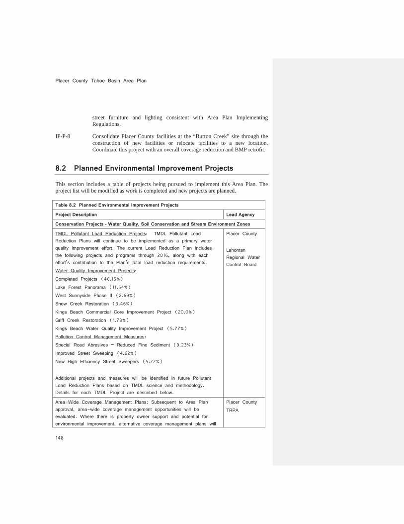
8.2 Planned Environmental Improvement Projects
This section includes a table of projects being pursued to implement this Area Plan. The project list will be modified as work is completed and new projects are planned.
Table 8.2 Planned Environmental Improvement Projects
Project Description Lead Agency
Conservation Projects – Water Quality, Soil Conservation and Stream Environment Zones
TMDL Pollutant Load Reduction Projects: TMDL Pollutant Load Reduction Plans will continue to be implemented as a primary water quality improvement effort. The current Load Reduction Plan includes the following projects and programs through 2016, along with each effort’s contribution to the Plan’s total load reduction requirements. Water Quality Improvement Projects: Completed Projects (46.15%) Lake Forest Panorama (11.54%) West Sunnyside Phase II (2.69%) Snow Creek Restoration (3.46%) Kings Beach Commercial Core Improvement Project (20.0%) Griff Creek Restoration (1.73%) Kings Beach Water Quality Improvement Project (5.77%) Pollution Control Management Measures: Special Road Abrasives – Reduced Fine Sediment (9.23%) Improved Street Sweeping (4.62%) New High Efficiency Street Sweepers (5.77%) Additional projects and measures will be identified in future Pollutant Load Reduction Plans based on TMDL science and methodology. Details for each TMDL Project are described below.
Placer County Lahontan Regional Water Control Board
Area-Wide Coverage Management Plans: Subsequent to Area Plan approval, area-wide coverage management opportunities will be evaluated. Where there is property owner support and potential for environmental improvement, alternative coverage management plans will
Placer County TRPA
Part 8: Implementation Plan Placer County Tahoe Basin Area Plan
149
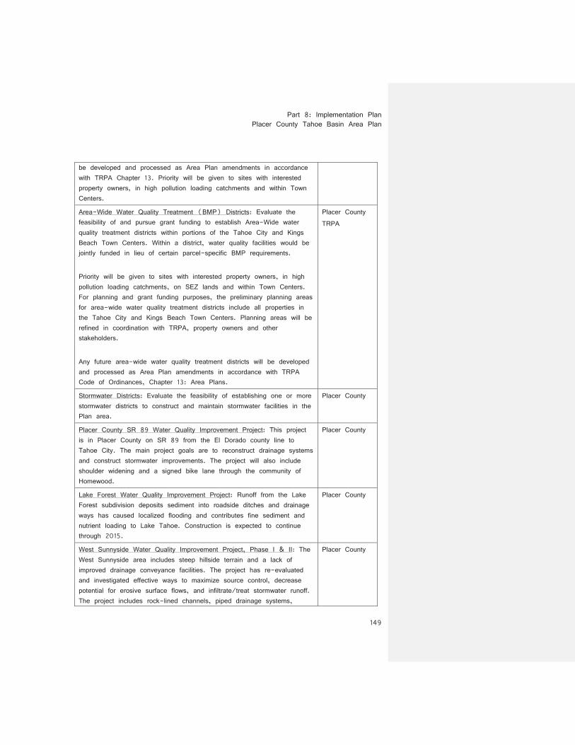
be developed and processed as Area Plan amendments in accordance with TRPA Chapter 13. Priority will be given to sites with interested property owners, in high pollution loading catchments and within Town Centers.
Area-Wide Water Quality Treatment (BMP) Districts: Evaluate the feasibility of and pursue grant funding to establish Area-Wide water quality treatment districts within portions of the Tahoe City and Kings Beach Town Centers. Within a district, water quality facilities would be jointly funded in lieu of certain parcel-specific BMP requirements. Priority will be given to sites with interested property owners, in high pollution loading catchments, on SEZ lands and within Town Centers. For planning and grant funding purposes, the preliminary planning areas for area-wide water quality treatment districts include all properties in the Tahoe City and Kings Beach Town Centers. Planning areas will be refined in coordination with TRPA, property owners and other stakeholders. Any future area-wide water quality treatment districts will be developed and processed as Area Plan amendments in accordance with TRPA Code of Ordinances, Chapter 13: Area Plans.
Placer County TRPA
Stormwater Districts: Evaluate the feasibility of establishing one or more stormwater districts to construct and maintain stormwater facilities in the Plan area.
Placer County
Placer County SR 89 Water Quality Improvement Project: This project is in Placer County on SR 89 from the El Dorado county line to Tahoe City. The main project goals are to reconstruct drainage systems and construct stormwater improvements. The project will also include shoulder widening and a signed bike lane through the community of Homewood.
Placer County
Lake Forest Water Quality Improvement Project: Runoff from the Lake Forest subdivision deposits sediment into roadside ditches and drainage ways has caused localized flooding and contributes fine sediment and nutrient loading to Lake Tahoe. Construction is expected to continue through 2015.
Placer County
West Sunnyside Water Quality Improvement Project, Phase I & II: The West Sunnyside area includes steep hillside terrain and a lack of improved drainage conveyance facilities. The project has re-evaluated and investigated effective ways to maximize source control, decrease potential for erosive surface flows, and infiltrate/treat stormwater runoff. The project includes rock-lined channels, piped drainage systems,
Placer County
Placer County Tahoe Basin Area Plan
150
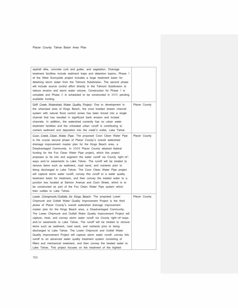
asphalt dike, concrete curb and gutter, and vegetation. Drainage treatment facilities include sediment traps and detention basins. Phase 1 of the West Sunnyside project includes a large treatment basin for detaining storm water from the Talmont Subdivision. The second phase will include source control effort directly in the Talmont Subdivision to reduce erosion and storm water volume. Construction for Phase 1 is complete and Phase 2 is scheduled to be constructed in 2015 pending available funding.
Griff Creek Watershed Water Quality Project: Due to development in the urbanized area of Kings Beach, the once braided stream channel system with natural flood control zones has been forced into a single channel that has resulted in significant bank erosion and incised channels. In addition, the watershed currently has no urban water treatment facilities and the untreated urban runoff is contributing to nutrient sediment and deposition into the creek’s outlet, Lake Tahoe.
Placer County
Coon Creek Clean Water Pipe: The proposed Coon Clean Water Pipe is the crucial second phase of Placer County’s overall watershed drainage improvement master plan for the Kings Beach area, a Disadvantaged Community. In 2009 Placer County attained federal funding for the Fox Clean Water Pipe project, which this project proposes to tie into and augment the water runoff via County right-of-ways and/or easements to Lake Tahoe. The runoff will be treated to remove items such as sediment, road sand, and nutrients prior to being discharged to Lake Tahoe. The Coon Clean Water Pipe project will capture storm water runoff, convey this runoff to a water quality treatment basin for treatment, and then convey the treated water to a junction box located at Salmon Avenue and Coon Street, which is to be constructed as part of the Fox Clean Water Pipe system which then outlets to Lake Tahoe.
Placer County
Lower Chimpmunk/Outfalls for Kings Beach: The proposed Lower Chipmunk and Outfall Water Quality Improvement Project is the third phase of Placer County’s overall watershed drainage improvement master plan for the Kings Beach area, a Disadvantaged Community. The Lower Chipmunk and Outfall Water Quality Improvement Project will capture, treat, and convey storm water runoff via County right-of-ways and/or easements to Lake Tahoe. The runoff will be treated to remove items such as sediment, road sand, and nutrients prior to being discharged to Lake Tahoe. The Lower Chipmunk and Outfall Water Quality Improvement Project will capture storm water runoff, convey this runoff to an advanced water quality treatment system consisting of filters and mechanical treatment, and then convey the treated water to Lake Tahoe. This project focuses on the treatment of the highest
Placer County
Part 8: Implementation Plan Placer County Tahoe Basin Area Plan
151
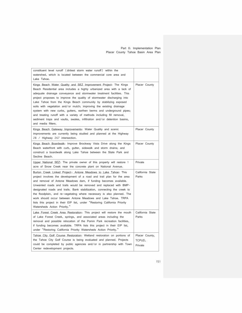
constituent level runoff (dirtiest storm water runoff) within the watershed, which is located between the commercial core area and Lake Tahoe.
Kings Beach Water Quality and SEZ Improvement Project: The Kings Beach Residential area includes a highly urbanized area with a lack of adequate drainage conveyance and stormwater treatment facilities. This project proposes to improve the quality of stormwater discharging into Lake Tahoe from the Kings Beach community by stabilizing exposed soils with vegetation and/or mulch; improving the existing drainage system with new curbs, gutters, earthen berms and underground pipes; and treating runoff with a variety of methods including fill removal, sediment traps and vaults, swales, infiltration and/or detention basins, and media filters.
Placer County
Kings Beach Gateway Improvements: Water Quality and scenic improvements are currently being studied and planned at the Highway 28 / Highway 267 intersection.
Placer County
Kings Beach Boardwalk: Improve Brockway Vista Drive along the Kings Beach waterfront with curb, gutter, sidewalk and storm drains; and construct a boardwalk along Lake Tahoe between the State Park and Secline Beach.
Placer County
Upper National SEZ: The private owner of this property will restore 1 acre of Snow Creek near the concrete plant on National Avenue.
Private
Burton Creek Linked Project- Antone Meadows to Lake Tahoe: This project involves the development of a road and trail plan for the area and removal of Antone Meadows dam, if funding becomes available. Unwanted roads and trails would be removed and replaced with BMP-designated roads and trails. Bank stabilization, connecting the creek to the floodplain, and re-vegetating where necessary is also planned. The work should occur between Antone Meadows and Lake Tahoe. TRPA lists this project in their EIP list, under “Restoring California Priority Watersheds Action Priority.”
California State Parks
Lake Forest Creek Area Restoration: This project will restore the mouth of Lake Forest Creek, springs, and associated areas including the removal and possible relocation of the Pomin Park recreation facilities, if funding becomes available. TRPA lists this project in their EIP list, under “Restoring California Priority Watersheds Action Priority.”
California State Parks
Tahoe City Golf Course Restoration: Wetland restoration on portions of the Tahoe City Golf Course is being evaluated and planned. Projects could be completed by public agencies and/or in partnership with Town Center redevelopment projects.
Placer County, TCPUD, Private
Placer County Tahoe Basin Area Plan
152
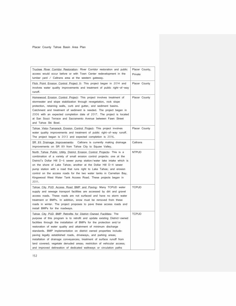
Truckee River Corridor Restoration: River Corridor restoration and public access would occur before or with Town Center redevelopment in the lumber yard / Caltrans area at the western gateway.
Placer County, Private
Flick Point Erosion Control Project II: This project began in 2014 and involves water quality improvements and treatment of public right-of-way runoff.
Placer County
Homewood Erosion Control Project: This project involves treatment of stormwater and slope stabilization through revegetation, rock slope protection, retaining walls, curb and gutter, and sediment basins. Catchment and treatment of sediment is needed. The project began in 2006 with an expected completion date of 2017. The project is located at San Souci Terrace and Sacramento Avenue between Fawn Street and Tahoe Ski Bowl.
Placer County
Tahoe Vista-Tamarack Erosion Control Project: This project involves water quality improvements and treatment of public right-of-way runoff. The project began is 2013 and expected completion is 2016.
Placer County
SR 89 Drainage Improvements: Caltrans is currently making drainage improvements on SR 89 from Tahoe City to Squaw Valley.
Caltrans
North Tahoe Public Utility District Erosion Control Projects: This is a combination of a variety of small erosion control projects: one at the District’s Dollar Hill D-6 sewer pump station/water lake intake which is on the shore of Lake Tahoe; another at the Dollar Hill D-4 sewer pump station with a road that runs right to Lake Tahoe; and erosion control on the access roads for the two water tanks in Carnelian Bay, Kingswood West Water Tank Access Road. These projects began in 2011.
NTPUD
Tahoe City PUD Access Road BMP and Paving: Many TCPUD water supply and sewage transport facilities are accessed by dirt and gravel access roads. These roads are not surfaced and have no storm water treatment or BMPs. In addition, snow must be removed from these roads in winter. The project proposes to pave these access roads and install BMPs for the roadways.
TCPUD
Tahoe City PUD BMP Retrofits for District-Owned Facilities: The purpose of this program is to retrofit and update existing District-owned facilities through the installation of BMPs for the protection and/or restoration of water quality and attainment of minimum discharge standards. BMP implementation on district owned properties include: paving legally established roads, driveways, and parking areas; installation of drainage conveyances; treatment of surface runoff from land covered; vegetate denuded areas; restriction of vehicular access; and improved delineation of dedicated walkways or circulation paths
TCPUD

Part 8: Implementation Plan Placer County Tahoe Basin Area Plan
153
within district-owned parks.
Tahoe City Snow Disposal Area Siting: The purpose of this project is to evaluate snow removal and disposal for the community, including community planning for snow management, disposal site selection, disposal site characteristics, and disposal site preparation in order to minimize the potential for negative environmental effects.
TCPUD
William Kent Campground and Day Use BMP Retrofit Phase 2: Beginning in 2015, this project will renovate facilities to complete improvements to circulation efficiency and campsite reconstruction.
USFS
William Kent Administration Site BMP: This project will install water quality protection BMPs and paving associated with the administrative facility. The project is scheduled to begin in 2015.
USFS
10-Year Program for Property Management: This program addresses smaller scale water quality issues, primarily on its urban lands and involves restoration of environmentally-sensitive and other urban lands to protect water quality in Lake Tahoe.
CTC
Tahoe Conservancy Riparian Wildlife and Upland Habitat Management Program: The goal of this program, which was initiated in 2010, is to enhance and restore riparian habitat throughout the region. Improvements include removing encroaching conifers from aspen stands, acquisition of sensitive riparian habitats, propagation and planting of native riparian species and small restoration projects in riparian habitats. This program also includes restoring complexity and diversity to the region’s forest through small selective cuts and prescribed burns.
CTC
Stormwater Infrastructure Mapping and Monitoring: Complete GIS mapping of all existing stormwater infrastructure and assemble water quality monitoring data for outlets to Lake Tahoe in coordination with other agencies and organizations.
Placer County
Soil Erosion Control Planning-Water Fund: This project is funded by a grant from the CTC. The original project was for erosion control measures at the North Tahoe Regional Park. Due to certain aspects of the original scope, the project was changed to identifying high priority areas needing erosion control measures. Three areas were identified: Carnelian Woods Tanks Road, Kingswood West Tank Site, and the Dollar Cove area there the District’s Dollar Main sere lift station is located.
NTPUD
SEZ Inventory and Tracking: In 2011, the PSW-SNPLMA began to develop a plan that involves creating an inventory, classification, and performance tracking system to support agency programs to restore and protect stream environment zones in the Lake Tahoe Basin.
PSW-SNPLMA
Placer County Tahoe Basin Area Plan
154
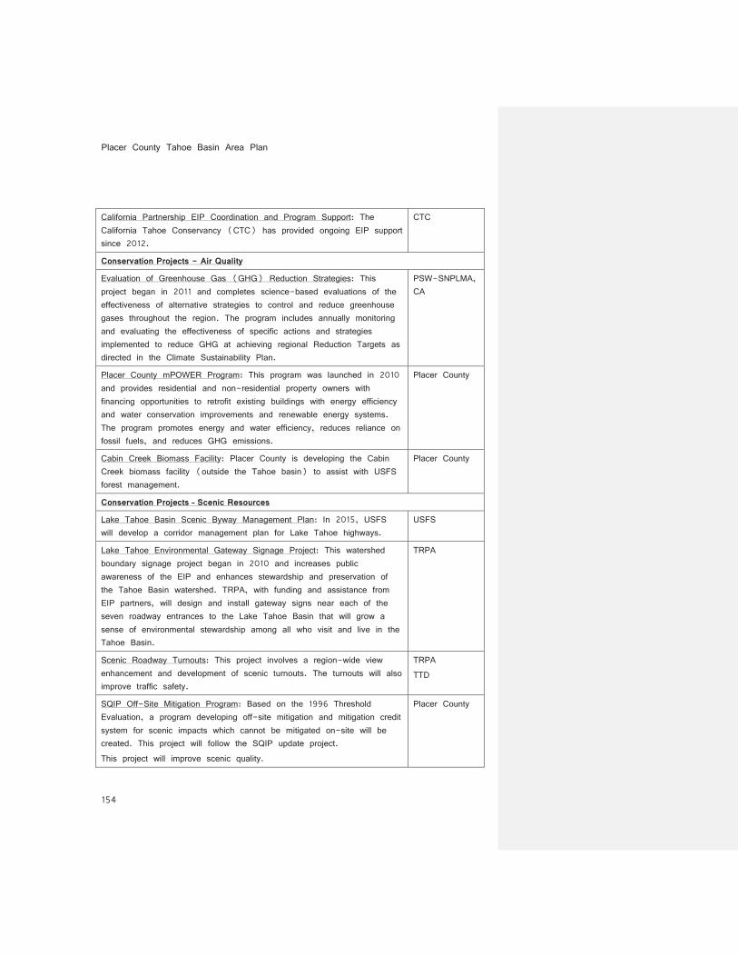
California Partnership EIP Coordination and Program Support: The California Tahoe Conservancy (CTC) has provided ongoing EIP support since 2012.
CTC
Conservation Projects - Air Quality
Evaluation of Greenhouse Gas (GHG) Reduction Strategies: This project began in 2011 and completes science-based evaluations of the effectiveness of alternative strategies to control and reduce greenhouse gases throughout the region. The program includes annually monitoring and evaluating the effectiveness of specific actions and strategies implemented to reduce GHG at achieving regional Reduction Targets as directed in the Climate Sustainability Plan.
PSW-SNPLMA, CA
Placer County mPOWER Program: This program was launched in 2010 and provides residential and non-residential property owners with financing opportunities to retrofit existing buildings with energy efficiency and water conservation improvements and renewable energy systems. The program promotes energy and water efficiency, reduces reliance on fossil fuels, and reduces GHG emissions.
Placer County
Cabin Creek Biomass Facility: Placer County is developing the Cabin Creek biomass facility (outside the Tahoe basin) to assist with USFS forest management.
Placer County
Conservation Projects – Scenic Resources
Lake Tahoe Basin Scenic Byway Management Plan: In 2015, USFS will develop a corridor management plan for Lake Tahoe highways.
USFS
Lake Tahoe Environmental Gateway Signage Project: This watershed boundary signage project began in 2010 and increases public awareness of the EIP and enhances stewardship and preservation of the Tahoe Basin watershed. TRPA, with funding and assistance from EIP partners, will design and install gateway signs near each of the seven roadway entrances to the Lake Tahoe Basin that will grow a sense of environmental stewardship among all who visit and live in the Tahoe Basin.
TRPA
Scenic Roadway Turnouts: This project involves a region-wide view enhancement and development of scenic turnouts. The turnouts will also improve traffic safety.
TRPA TTD
SQIP Off-Site Mitigation Program: Based on the 1996 Threshold Evaluation, a program developing off-site mitigation and mitigation credit system for scenic impacts which cannot be mitigated on-site will be created. This project will follow the SQIP update project. This project will improve scenic quality.
Placer County

Part 8: Implementation Plan Placer County Tahoe Basin Area Plan
155
Wayfinding Sign Program: Implement the Placer County Wayfinding Signage Plan to improve the visitor experience and reduce auto trips.
Placer County
Scenic Shoreline Unit #12- Improve Marina Facilities at McKinney Bay: Boat storage structures at Obexers and Homewood High and Dry need to be redesigned and screened by landscaping. Marina buildings that contrast with surroundings need to be painted and/or articulation added to the design of the buildings where appropriate to minimize the perception of bulk.
Private
Scenic Shoreline Unit #14- Ward Creek Improvements: This private project involves providing landscape screening, removing and/or reducing clutter and superstructures on certain shorezone structures, removing derelict piers and boathouses, and reducing contrast of highly contrasting buildings and structures along the shoreline.
Private
Scenic Shoreline Unit #16- Lake Forest Improvements: This project involves providing landscape screening in mapped areas of concern including Coast Guard/Lake Forest boat ramp parking areas, undergrounding overhead utility lines in Dollar Point, relocating or screening satellite dishes, and revegetation and reducing Rocky Point contrast.
Private
Scenic Shoreline Unit #18- Cedar Flat Improvements: This project involves providing landscape screening, removing or reducing clutter and superstructures on certain shorezone structures, removing derelict piers and boathouses, reducing contrast of highly contrasting buildings and structures along the shoreline.
Private
Scenic Roadway Unit #9- Tahoma Improvements: This is a project that began in 2010 that involves streetscape improvements including sign conformance, frontage landscaping, and walkways and access controls throughout the mapped area of concern. Utility lines adjacent to roadways were also undergrounded throughout the unit.
Private
Scenic Roadway Unit #11- Homewood Improvements: This project began in 2010 and implements landscape frontage improvements, access controls, building upgrades, sign conformance, and walkways throughout the mapped area of concern. Utility lines adjacent to roadways were also undergrounded throughout the unit.
Private
Scenic Roadway Unit #13- Sunnyside Improvements: This project began in 2010 and implements landscape frontage improvements, access controls, building upgrades, sign conformance, and walkways throughout the mapped area of concern. Utilities adjacent to the roadway were undergrounded. Solid barriers along Ward Creek were also removed.
Private
Placer County Tahoe Basin Area Plan
156
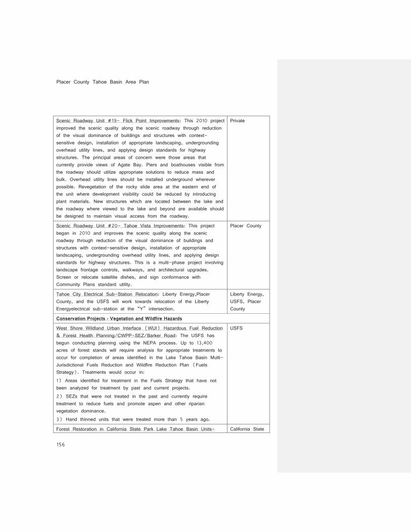
Scenic Roadway Unit #19- Flick Point Improvements: This 2010 project improved the scenic quality along the scenic roadway through reduction of the visual dominance of buildings and structures with context-sensitive design, installation of appropriate landscaping, undergrounding overhead utility lines, and applying design standards for highway structures. The principal areas of concern were those areas that currently provide views of Agate Bay. Piers and boathouses visible from the roadway should utilize appropriate solutions to reduce mass and bulk. Overhead utility lines should be installed underground wherever possible. Revegetation of the rocky slide area at the eastern end of the unit where development visibility could be reduced by introducing plant materials. New structures which are located between the lake and the roadway where viewed to the lake and beyond are available should be designed to maintain visual access from the roadway.
Private
Scenic Roadway Unit #20- Tahoe Vista Improvements: This project began in 2010 and improves the scenic quality along the scenic roadway through reduction of the visual dominance of buildings and structures with context-sensitive design, installation of appropriate landscaping, undergrounding overhead utility lines, and applying design standards for highway structures. This is a multi-phase project involving landscape frontage controls, walkways, and architectural upgrades. Screen or relocate satellite dishes, and sign conformance with Community Plans standard utility.
Placer County
Tahoe City Electrical Sub-Station Relocation: Liberty Energy,Placer County, and the USFS will work towards relocation of the Liberty Energyelectrical sub-station at the “Y” intersection.
Liberty Energy, USFS, Placer County
Conservation Projects – Vegetation and Wildfire Hazards
West Shore Wildland Urban Interface (WUI) Hazardous Fuel Reduction & Forest Health Planning/CWPP-SEZ/Barker Road: The USFS has begun conducting planning using the NEPA process. Up to 13,400 acres of forest stands will require analysis for appropriate treatments to occur for completion of areas identified in the Lake Tahoe Basin Multi-Jurisdictional Fuels Reduction and Wildfire Reduction Plan (Fuels Strategy). Treatments would occur in: 1) Areas identified for treatment in the Fuels Strategy that have not been analyzed for treatment by past and current projects. 2) SEZs that were not treated in the past and currently require treatment to reduce fuels and promote aspen and other riparian vegetation dominance. 3) Hand thinned units that were treated more than 5 years ago.
USFS
Forest Restoration in California State Park Lake Tahoe Basin Units- California State

Part 8: Implementation Plan Placer County Tahoe Basin Area Plan
157
Phases I-III: This program restores and improves forest health within park units by managing trees and reduces hazardous trees and fuel loads along park boundaries and adjacent to development.
Parks
Tahoe Conservancy Forest Fuels Reduction Program: This program uses site-specific prescriptions and treatment methods to reduce the accumulation of forest fuels on Conservancy lands.
CTC
Tahoe Conservancy Riparian Wildlife and Upland Habitat Management Program: The goal of this program, which was initiated in 2010, is to enhance and restore riparian habitat throughout the region. Improvements include removing encroaching conifers from aspen stands, acquisition of sensitive riparian habitats, propagation and planting of native riparian species and small restoration projects in riparian habitats. This program also includes restoring complexity and diversity to the region’s forest through small selective cuts and prescribed burns.
CTC
North Tahoe Public Utility District Hazardous Fuels Treatment at North Tahoe Regional Park: The NTPUD has developed a forest management plan and implements and carries out fuel reduction on forested areas on District-owned properties.
NTPUD
Forest Health/Fuels Reduction on Placer County Private Lands: This is an ongoing program that provides funding for qualified contractors to treat hazardous fuels on Placer County owned and/or controlled lands, as well as includes a grant program for private property owners to treat hazardous fuels on private lands.
Placer County Private
Carnelian Hazardous Fuels Reduction & Healthy Forest Restoration: Initiated in 2012, this program continues to implement hazardous fuel reduction and ecosystem health treatments on approximately 813 acres for the north shore area of the Lake Tahoe Basin. These fuel reduction treatments cover the National Forest areas in the Carnelian Bay area and would focus on the administered contracts and through Fire Safe Councils. These treatments reduce the level of hazardous fuels within the defense and threat zones, accomplished through the use of hand thinning, pile and burn, as well as mechanical thin and biomass removal contracts on both upland and riparian areas.
USFS
Lake Tahoe Basin Prescribed Fire Annual Pile Burns: The purpose of this project is to reduce fuel loading to safe and acceptable levels within the wildland urban interface (WUI) and to re-introduce low to moderate intensity fire back into a fire adapted ecosystem for improvement of forest health and wildlife habitat.
USFS
Stewardship Fireshed Assessment (SFA) Update (Next 10 Years): Initiated in 2013, the USFS began updating their Stewardship Fireship Assessment (SFA) strategy for the next 10 years of vegetation/fuels
USFS
Placer County Tahoe Basin Area Plan
158
treatment beyond WUI and focus on ecosystem restoration. Project-level planning has also begun.
Cal Fire Lake Tahoe Defensible Space Inspection Program: From 2012-2017, Cal Fire is performing defensible space inspections in the Lake Tahoe Basin.
CAL FIRE
Conservation Projects – Fisheries, Aquatic Resources and Wildlife
Early Detection of and Rapid Response to New Aquatic Invasive Species Infestations (2012-2016): This is a joint-implementation program between USFWS, TRPA, TERC, UNR, and TRCD. The program goal is to ensure that the Lake Tahoe region is prepared to meet the threat of new aquatic invasive species infestations. A program that incorporates both monitoring and rapid response needs to be established and maintained. The first component of this program is a multi-taxa monitoring program for new infestations of aquatic invasive species to be carried out as a coordinated basin-wide effort. This monitoring will allow for new infestations to be detected while the efforts needed to remove these infestations are still comparatively small. Should new infestations such as Quagga or Zebra Mussels must be in-place, including equipment, personnel, agency agreements and operations guidance. This project includes development, oversight, and implementation of the strategy for monitoring and response, obtain and cache equipment and institute agency agreements for personnel and administration should new infestations occur.
USFWS, TRPA, TERC, UNR, TRCD
Control and Management of Current Aquatic Invasive Species Infestations (2012-2016): This program focuses on removal activities of invasive species infestations that currently exist in the Lake Tahoe region and identified by the Lake Tahoe Aquatic Invasive Species Coordination Committee. Individual projects may involve the removal of aquatic invasive species from nearshore Lake Tahoe, small lakes, rivers, streams, and other habitats within the region. Monitoring of the status and trends of multiple aquatic invasive species infestations and effectiveness monitoring of individual treatment areas are also included in this program, as is oversight and administration of individual projects.
TRCD, California State Parks, TRPA
Prevention of New Aquatic Species Infestations (2012-2016): This program involves the continued implementation of Aquatic Invasive Species prevention efforts within the Lake Tahoe region. Methods follow existing plans and protocols developed by the Lake Tahoe Aquatic Invasive Species Coordination Committee, and include education/outreach, watercraft inspections and decontaminations which follow guidelines developed by TRPA, the 100th Meridian Initiative, the Lake Tahoe Aquatic Invasive Species Integrated Management Plan, and
TRPA, TRCD, NTPUD, NDSP, NDOW, CDFW, IVGID, TCPUD, CSLT, USFS, USFWS
Part 8: Implementation Plan Placer County Tahoe Basin Area Plan
159
the states of Nevada and California. This program includes threat assessment, updates to inspection protocols, inspector certification, detection notification procedures, decontamination, quarantine, and oversight and administration.
Dollar Creek Restoration: This project will remove or remediate impacts from an abandoned dam, replace undersized culverts to enhance fish passage, and enhance riparian vegetation.
CTC
Aquatic Organism Passage: This project reconstructs identified road crossings of stream corridors to remove barriers to aquatic organism passage.
USFS
Land Use Projects
Continue Sensitive Land Acquisitions: Secure funds to purchase private lands in sensitive areas from willing sellers and in coordination with the California Tahoe Conservancy and other partner organizations.
Placer County, CTC, USFS
Implement and Monitor the Effectiveness of Regional Plan Redevelopment Incentives: Adopting a new Area Plan that implements Regional Plan Redevelopment incentives for building height, density, land coverage, and development transfers.
Placer County
Encourage Mixed Use Development in the Placer County Tahoe Basin Area Plan Update: The Placer County Tahoe Basin Area Plan Update identifies Town Centers in urban areas of the Tahoe Basin for mixed use development. Compact and mixed-use development patterns enable walking and bicycling and shorter automobile trips, reducing dependency on fossil fuels for transportation and ultimately reducing greenhouse gas emissions.
Placer County
Implement and Monitor Pilot Projects for Converting CFA to TAUs: Area Plan provisions for the conversion of CFA to TAUs will be established, monitored for efficacy, and potentially improved based on monitoring results. The program will allow Placer County communities to achieve a more balanced land use pattern with lodging units to accommodate more of the region’s visitors. The program should enable Town Center redevelopment and reduce auto dependency.
Placer County TRPA
Parking Standard Reforms and Community Parking Options: Consistent with Regional Plan provisions, new shared use and site specific parking standards will be implemented in the Area Plan. Additionally, Placer County will evaluate additional community parking systems such as parking assessment districts and in-lieu parking fee systems. Amendments are intended to reduce the amount of pavement and make more efficient use of parking areas. This should benefit water quality
Placer County

Placer County Tahoe Basin Area Plan
160
other environmental conditions.
Kings Beach Library Relocation: In conjunction with Griff Creek improvements, the Kings Beach library is planned to be relocated from SEZ to high capability lands.
Placer County
Tahoe Livable Communities Program: The California Tahoe Conservancy’s Tahoe Livable Communities Program could significantly reduce greenhouse gas emissions, restore environmentally sensitive lands, and help revitalize the Lake Tahoe Basin’s urban centers. This program will refocus the Conservancy’s land acquisition and marketable right programs to: 1) Acquire and restore aging developed properties on environmentally sensitive lands and retire or transfer the development rights to Town Centers; 2) Sell, lease, or exchange vacant Conservancy land in these Town Centers; and 3) Acquire the remaining private properties in several of Lake Tahoe’s roadless subdivisions to remove the threat of development.
CTC
Transportation Projects
The Kings Beach Commercial Core Project: This project will change the current auto-dominated section of SR 28 between Secline Avenue on the east and Beaver Street on the west to a pedestrian- and bicycle-friendly corridor. The existing two travel lanes in each direction will be converted to one travel lane in each direction plus a center two-way left turn lane, sidewalks, and bicycle lanes. Roundabouts will be constructed at Bear Street and Coon Street (replacing the existing signal at the latter cross-street). In addition, Brook Street will be converted to one-way eastbound, and extensive water quality improvements will be constructed throughout the area.
Placer County
Lakeside Project: This is a Caltrans project that will implement water quality control improvements along SR 89 between Tahoe City and Tahoma. This will include widening to provide left turn lanes in key areas such as Sunnyside and Homewood, as well as construct elements of the missing portion of multipurpose bicycle/pedestrian trail directly adjacent to the highway in the Homewood area. It is planned for completion by 2016.
Caltrans
TART Systems Plan Update The Placer County TART Systems Plan Update (2016) is a culmination of work conducted by the North Tahoe Transit Vision Coalition from 2012 through 2016. The plan outlines priority transit service improvements and also identifies funding sources to expand and
Part 8: Implementation Plan Placer County Tahoe Basin Area Plan
161
enhance transit service within the “Resort Triangle” area of North Lake Tahoe. Funding opportunities could be generated from local, State, and Federal sources, as well as private contributions through development and redevelopment.
SR 89/Fanny Bridge Community Revitalization Project: This project is a roadway modification and community revitalization plan, approved in May 2015 and developed by the Tahoe Transportation District (TTD) and Placer County for the Fanny Bridge area in Tahoe City. It addresses existing traffic congestion and poor bicycle/pedestrian conditions with a new State highway alignment and bridge over the Truckee River to the south of the existing Fanny Bridge, along with significant pedestrian and bicycle improvements. Construction is scheduled to begin in 2016. The project was approved with the Alternative 1, Option 2 design. New roundabouts are planned at the Tahoe City wye and at both ends of the new roadway segment. Bike Lane and sidewalk connections will be completed between the east and wye roundabout, the west and wye roundabout and the east end of the project area on Highway 28. Multi-use trail improvements will connect the east and west roundabouts and pass under the new bridge on both sides of the Truckee River. It is the joint desire of TRPA, The Tahoe Metropolitan Planning Organization, Tahoe Transportation District (TTD)and Placer County to revitalize the Fanny Bridge and Tahoe City River District Special Planning Area into a pedestrian and bicycle friendly zone. After completion of construction of the SR 89/Fanny Bridge Community Revitalization Project, the County shall consider special outdoor events and roadway closures of the old SR 89/Fanny Bridge area thru temporary outdoor event permits, special event encroachment permits, and selected closures determined by Placer County. Potential impacts to local businesses and traffic impacts associated with special events shall be considered and accommodated where feasible on a case by case basis. In order to monitor activity in the SR 89/Fanny Bridge area, volume count stations will be installed with the SR 89/Fanny Bridge Community Revitalization Project. The County will make collected data from count stations available to local jurisdictional partners upon request. Initial peak and non-peak hour volume data will be obtained after completion of the SR 89/Fanny Bridge Revitalization Project to establish a volume and mode baseline. Additional monitoring of bicycle and pedestrian activity, sales tax receipts, and other data will be
TTD, TRPA, Placer County
Placer County Tahoe Basin Area Plan
162
coordinated with TRPA and TTD. Future volume monitoring will be performed consistent with the County roadway monitoring practices and the Region’s Lake Tahoe Bicycle and Pedestrian Monitoring Protocol.
Tahoe City Mobility Plan: The Tahoe City Mobility Plan is intended to further design for future connectivity and advance solutions for community cohesion in downtown Tahoe City. The Plan addresses pedestrian and bicycle corridor gaps in Tahoe City, including the “missing link” in the shared use path between Commons Beach and the wye. The Plan also provides complete street strategies to improve parking and circulation along SR 28 near Grove Street, and to establish a vibrant pedestrian-oriented downtown with safe crossings along SR 28 to Lake Tahoe, Commons Beach and the Truckee River.
Placer County
Kings Beach Mobility Improvements: Options will be analyzed to enhance mobility in Kings Beach, including trails, shared use paths, and parking and circulation improvements. Focus will be on implementation of a shared use path or boardwalk along the lake side between Secline Beach to the west and Chipmunk Street to the east, better utilization and integration of the Kings Beach State Recreation Area parking lot, improved circulation and pedestrian and bicycle safety around the SR 28/SR 267 intersection, and improved trail connections within the Kings Beach community. The improvements will supplement the sidewalks, trails and parking areas that have already been established and are being built as part of the Kings Beach Commercial Core Improvement Project.
Placer County
SR 28 Tahoe City to SR 276 Intersection: The project area is along 9 miles of SR 28 in Placer County from Tahoe City to the intersection of SR 267 at Kings Beach. Road runoff treatment and erosion control facilities need to be installed.
Caltrans
SR 28 Tahoe State Park to SR 276: The intersection of SR 28 and SR 267 will be analyzed for options to addturn lanes to aid traffic flow, and to improve pedestrian and bicycle safety, and mobility
Caltrans
Kings Beach Industrial: Drainage conveyance stabilization, revegetation, road runoff treatment, and pavement modifications are needed in this project area.
Placer County
Kings Beach CCIP: Beaver Street: This project includes constructing erosion source controls and stormwater treatment facilities associated with the County roadway. Improvements will include revegetation of disturbed soils, drainage stabilization, and infiltration and sediment ponds.
Placer County
Part 8: Implementation Plan Placer County Tahoe Basin Area Plan
163
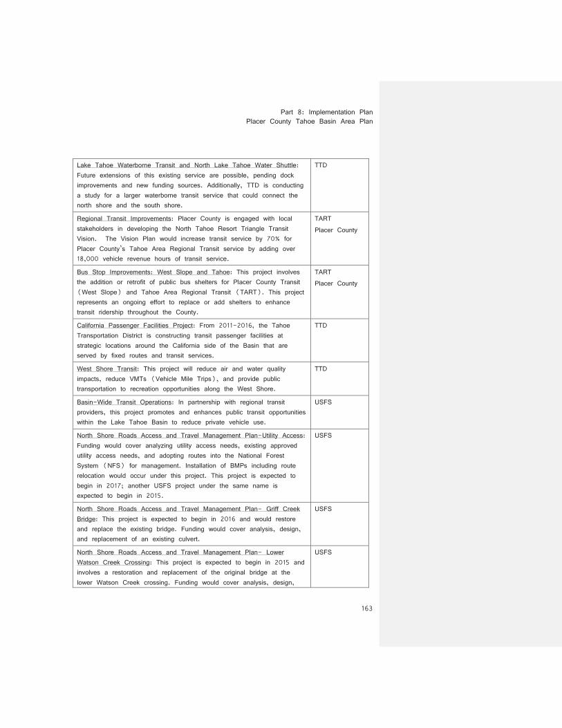
Lake Tahoe Waterborne Transit and North Lake Tahoe Water Shuttle: Future extensions of this existing service are possible, pending dock improvements and new funding sources. Additionally, TTD is conducting a study for a larger waterborne transit service that could connect the north shore and the south shore.
TTD
Regional Transit Improvements: Placer County is engaged with local stakeholders in developing the North Tahoe Resort Triangle Transit Vision. The Vision Plan would increase transit service by 70% for Placer County’s Tahoe Area Regional Transit service by adding over 18,000 vehicle revenue hours of transit service.
TART Placer County
Bus Stop Improvements: West Slope and Tahoe: This project involves the addition or retrofit of public bus shelters for Placer County Transit (West Slope) and Tahoe Area Regional Transit (TART). This project represents an ongoing effort to replace or add shelters to enhance transit ridership throughout the County.
TART Placer County
California Passenger Facilities Project: From 2011-2016, the Tahoe Transportation District is constructing transit passenger facilities at strategic locations around the California side of the Basin that are served by fixed routes and transit services.
TTD
West Shore Transit: This project will reduce air and water quality impacts, reduce VMTs (Vehicle Mile Trips), and provide public transportation to recreation opportunities along the West Shore.
TTD
Basin-Wide Transit Operations: In partnership with regional transit providers, this project promotes and enhances public transit opportunities within the Lake Tahoe Basin to reduce private vehicle use.
USFS
North Shore Roads Access and Travel Management Plan-Utility Access: Funding would cover analyzing utility access needs, existing approved utility access needs, and adopting routes into the National Forest System (NFS) for management. Installation of BMPs including route relocation would occur under this project. This project is expected to begin in 2017; another USFS project under the same name is expected to begin in 2015.
USFS
North Shore Roads Access and Travel Management Plan- Griff Creek Bridge: This project is expected to begin in 2016 and would restore and replace the existing bridge. Funding would cover analysis, design, and replacement of an existing culvert.
USFS
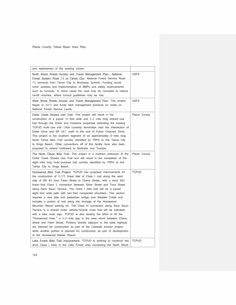
North Shore Roads Access and Travel Management Plan- Lower Watson Creek Crossing: This project is expected to begin in 2015 and involves a restoration and replacement of the original bridge at the lower Watson Creek crossing. Funding would cover analysis, design,
USFS
Placer County Tahoe Basin Area Plan
164
and replacement of the existing culvert.
North Shore Roads Access and Travel Management Plan- National Forest System Road 73 at Tahoe City: National Forest Service Road 73 connects from Tahoe City to Brockway Summit. Funding would cover analysis and implementation of BMPs and safety improvements such as turnouts. In some cases the road may be narrowed to reduce runoff volumes, where turnout guidelines may be met.
USFS
West Shore Roads Access and Travel Management Plan: This project began in 2013 and funds best management practices on roads on National Forest Service Lands.
USFS
Dollar Creek Shared Use Trail: This project will result in the construction of a paved 10-foot wide and 2.2 mile long shared-use trail through the Dollar and Firestone properties extending the existing TCPUD multi-use trail (that currently terminates near the intersection of Dollar Drive and SR 28) north to the end of Fulton Crescent Drive. This project is the southern segment of an approximately 8-mile long North Tahoe Bike Trail corridor identified by TRPA to link Tahoe City to Kings Beach. Other connections off of this facility have also been proposed to extend northward to Northstar and Truckee.
Placer County
The North Tahoe Bike Trail: This project is a northern extension of the Dollar Creek Shared Use Trail and will result in the completion of the eight-mile long multi-purpose trail corridor identified by TRPA to link Tahoe City to Kings Beach.
Placer County
Homewood Bike Trail Project: TCPUD has proposed improvements for the construction of 4,175 linear feet of Class I trail along the west side of SR 89 from Fawn Street to Cherry Street, with a short 885 linear-foot Class 3 connection between Silver Street and Trout Street along Sans Souci Terrace. The Class I bike trail will be a paved eight-foot wide path with two-foot compacted shoulders. This section requires a new bike and pedestrian bridge over Madden Creek and includes a portion of trail along the frontage of the Homewood Mountain Resort parking lot. The Class III connection along Sans Souci Terrace is a shared motor vehicle/bicycle route that will be indicated with a bike route sign. TCPUD is also leading the effort to fill the “Homewood Hole,” a 0.9-mile gap in the west shore between Cherry Street and Fawn Street. Portions directly adjacent to the state highway are planned for construction as part of the Lakeside erosion project, while another portion is planned for construction as part of development of the Homewood Master Resort.
TCPUD
Lake Forest Bike Trail Improvement: TCPUD is working to construct two short Class I trails in the Lake Forest area connecting the North Shore
TCPUD
Part 8: Implementation Plan Placer County Tahoe Basin Area Plan
165
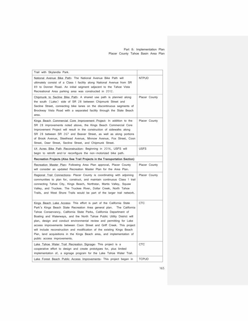
Trail with Skylandia Park.
National Avenue Bike Path: The National Avenue Bike Path will ultimately consist of a Class I facility along National Avenue from SR 89 to Donner Road. An initial segment adjacent to the Tahoe Vista Recreational Area parking area was constructed in 2012.
NTPUD
Chipmunk to Secline Bike Path: A shared use path is planned along the south (Lake) side of SR 28 between Chipmunk Street and Secline Street, connecting bike lanes on the discontinuous segments of Brockway Vista Road with a separated facility through the State Beach area.
Placer County
Kings Beach Commercial Core Improvement Project: In addition to the SR 28 improvements noted above, the Kings Beach Commercial Core Improvement Project will result in the construction of sidewalks along SR 28 between SR 267 and Beaver Street, as well as along portions of Brook Avenue, Steelhead Avenue, Minnow Avenue, Fox Street, Coon Street, Deer Street, Secline Street, and Chipmunk Street.
Placer County
64 Acres Bike Path Reconstruction: Beginning in 2016, USFS will begin to retrofit and/or reconfigure the non-motorized bike path.
USFS
Recreation Projects (Also See Trail Projects in the Transportation Section)
Recreation Master Plan: Following Area Plan approval, Placer County will consider an updated Recreation Master Plan for the Area Plan.
Placer County
Regional Trail Connections: Placer County is coordinating with adjoining communities to plan for, construct, and maintain continuous Class 1 trail connecting Tahoe City, Kings Beach, Northstar, Martis Valley, Squaw Valley, and Truckee. The Truckee River, Dollar Creek, North Tahoe Trails, and West Shore Trails would be part of the larger trail network.
Placer County
Kings Beach Lake Access: This effort is part of the California State Park’s Kings Beach State Recreation Area general plan. The California Tahoe Conservancy, California State Parks, California Department of Boating and Waterways, and the North Tahoe Public Utility District will plan, design and conduct environmental review and permitting for Lake access improvements between Coon Street and Griff Creek. This project will include reconstruction and modification of the existing Kings Beach Pier, land acquisitions in the Kings Beach area, and implementation of public access improvements.
CTC
Lake Tahoe Water Trail Recreation Signage: This project is a cooperative effort to design and create prototypes for, plus limited implementation of, a signage program for the Lake Tahoe Water Trail.
CTC
Lake Forest Beach Public Access Improvements: This project began in TCPUD

Placer County Tahoe Basin Area Plan
166
2011 and involves the extension of water lines to provide for water service, fire protection, and permanent restrooms at Lake Forest Beach.
Kings Beach Day Use Area Rehabilitation and Erosion Control Retrofitting: This effort is part of the California State Park’s Kings Beach State Recreation Area general plan. This project includes: the design and construction of BMPs; erosion controls, including construction of a beach sand retaining wall; replacement of existing walkways to meet ADA standards; rehabilitation and replacement of park facilities including picnic sites, kiosk, miscellaneous structures, and associated parking and pier access.
California State Parks
Tahoe State Recreation Area Rehabilitation and Erosion Control: This project includes facilities, road and trail, and BMP planning and implementation for developed areas including paved roads, historic sites, buildings, etc., if funding becomes available. This project excludes campgrounds rehabilitated with BMPs under separate EIP project numbers.
California State Parks
Cultural Resource Inventory- CA State Park Lake Tahoe Basin Units: California State Parks is conducting an ongoing cultural resource inventory at each Lake Tahoe Basin park unit. The information will be used to protect all sites when EIP projects are implemented.
California State Parks
Tahoe State Recreation Area Pier Replacements: Replacement of State Recreation Area piers is being considered and planned, if funding becomes available
California State Parks
Public Access/Recreation Acquisitions: The California Tahoe Conservancy will purchase property on the California side of the Tahoe Region to support public access goals by providing opportunities for dispersed recreation including trails and trailheads, in natural and potential sites for day use and overnight facilities.
CTC
64 Acres Recreational Access Improvements: This project includes construction of permanent restroom facilities, construction of additional public parking, and installation of barriers to protect vegetation and reduce compaction of natural areas.
TCPUD
Skylandia Park Public Access Improvements: This project involves the reconstruction of water lines to provide for fire protection and the construction of a picnic pavilion with ADA access.
TCPUD
Speedboat Beach Master Plan: Park, Beach and Lake Access improvements at Speedboat Beach.
Placer County
West Shore Trail Access and Travel Management- Tahoma Trail: This project is planned to begin in 2017 and implements reconstruction and BMP installation on existing trails within the Tahoe Shore Trail Access
USFS
Part 8: Implementation Plan Placer County Tahoe Basin Area Plan
167
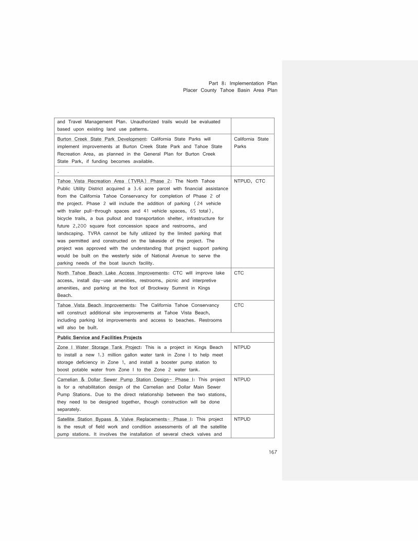
and Travel Management Plan. Unauthorized trails would be evaluated based upon existing land use patterns.
Burton Creek State Park Development: California State Parks will implement improvements at Burton Creek State Park and Tahoe State Recreation Area, as planned in the General Plan for Burton Creek State Park, if funding becomes available.
California State Parks
.
Tahoe Vista Recreation Area (TVRA) Phase 2: The North Tahoe Public Utility District acquired a 3.6 acre parcel with financial assistance from the California Tahoe Conservancy for completion of Phase 2 of the project. Phase 2 will include the addition of parking (24 vehicle with trailer pull-through spaces and 41 vehicle spaces, 65 total), bicycle trails, a bus pullout and transportation shelter, infrastructure for future 2,200 square foot concession space and restrooms, and landscaping. TVRA cannot be fully utilized by the limited parking that was permitted and constructed on the lakeside of the project. The project was approved with the understanding that project support parking would be built on the westerly side of National Avenue to serve the parking needs of the boat launch facility.
NTPUD, CTC
North Tahoe Beach Lake Access Improvements: CTC will improve lake access, install day-use amenities, restrooms, picnic and interpretive amenities, and parking at the foot of Brockway Summit in Kings Beach.
CTC
Tahoe Vista Beach Improvements: The California Tahoe Conservancy will construct additional site improvements at Tahoe Vista Beach, including parking lot improvements and access to beaches. Restrooms will also be built.
CTC
Public Service and Facilities Projects
Zone I Water Storage Tank Project: This is a project in Kings Beach to install a new 1.3 million gallon water tank in Zone I to help meet storage deficiency in Zone 1, and install a booster pump station to boost potable water from Zone I to the Zone 2 water tank.
NTPUD
Carnelian & Dollar Sewer Pump Station Design- Phase I: This project is for a rehabilitation design of the Carnelian and Dollar Main Sewer Pump Stations. Due to the direct relationship between the two stations, they need to be designed together, though construction will be done separately.
NTPUD
Satellite Station Bypass & Valve Replacements- Phase I: This project is the result of field work and condition assessments of all the satellite pump stations. It involves the installation of several check valves and
NTPUD
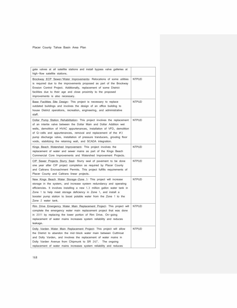
Placer County Tahoe Basin Area Plan
168
gate valves at all satellite stations and install bypass valve galleries at high-flow satellite stations.
Brockway ECP Sewer/Water Improvements: Relocations of some utilities is required due to the improvements proposed as part of the Brockway Erosion Control Project. Additionally, replacement of some District facilities due to their age and close proximity to the proposed improvements is also necessary.
NTPUD
Base Facilities Site Design: This project is necessary to replace outdated buildings and involves the design of an office building to house District operations, recreation, engineering, and administrative staff.
NTPUD
Dollar Pump Station Rehabilitation: This project involves the replacement of an intertie valve between the Dollar Main and Dollar Addition wet wells, demolition of HVAC appurtenances, installation of VFD, demolition of Q-cells and appurtenances, removal and replacement of the #3 pump discharge valve, installation of pressure tranducers, grouting floor voids, stabilizing the retaining wall, and SCADA integration.
NTPUD
Kings Beach Watershed Improvement: This project involves the replacement of water and sewer mains as part of the Kings Beach Commercial Core Improvements and Watershed Improvement Projects.
NTPUD
CIP Sewer Projects Slurry Seal: Slurry seal of pavement to be done one year after CIP project completion as required by Placer County and Caltrans Encroachment Permits. This project fulfills requirements of Placer County and Caltrans linear projects.
NTPUD
New Kings Beach Water Storage-Zone 1: This project will increase storage in the system, and increase system redundancy and operating efficiencies. It involves installing a new 1.3 million gallon water tank in Zone 1 to help meet storage deficiency in Zone 1, and install a booster pump station to boost potable water from the Zone 1 to the Zone 2 water tank.
NTPUD
Rim Drive Emergency Water Main Replacement Project: This project will complete the emergency water main replacement project that was done in 2011 by replacing the lower portion of Rim Drive. On-going replacement of water mains increases system reliability and reduces leakage.
NTPUD
Dolly Varden Water Main Replacement Project: This project will allow the District to abandon the mid-block water main between Cutthroat and Dolly Varden, and involves the replacement of water mains in Dolly Varden Avenue from Chipmunk to SR 267. The ongoing replacement of water mains increases system reliability and reduces
NTPUD
Part 8: Implementation Plan Placer County Tahoe Basin Area Plan
169
leakage.
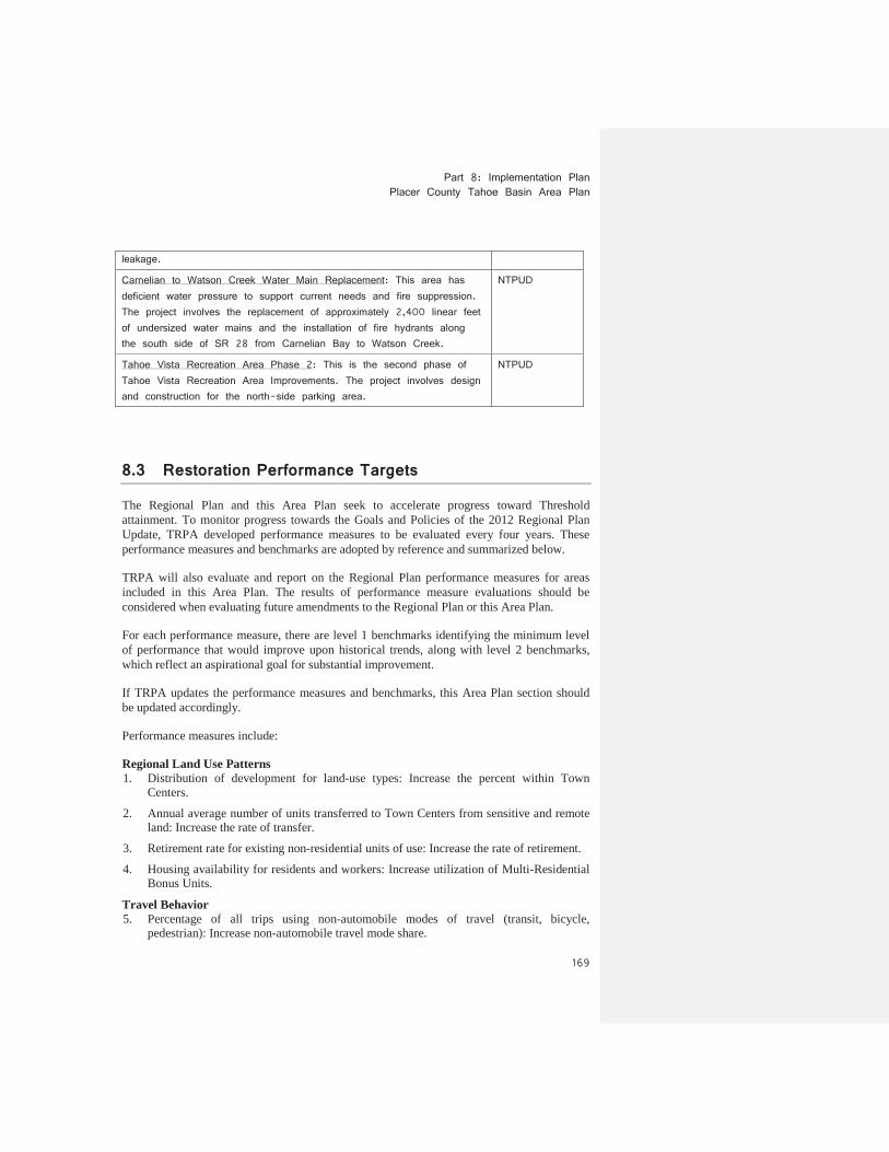
Carnelian to Watson Creek Water Main Replacement: This area has deficient water pressure to support current needs and fire suppression. The project involves the replacement of approximately 2,400 linear feet of undersized water mains and the installation of fire hydrants along the south side of SR 28 from Carnelian Bay to Watson Creek.
NTPUD
Tahoe Vista Recreation Area Phase 2: This is the second phase of Tahoe Vista Recreation Area Improvements. The project involves design and construction for the north-side parking area.
NTPUD
8.3 Restoration Performance Targets
The Regional Plan and this Area Plan seek to accelerate progress toward Threshold attainment. To monitor progress towards the Goals and Policies of the 2012 Regional Plan Update, TRPA developed performance measures to be evaluated every four years. These performance measures and benchmarks are adopted by reference and summarized below.
TRPA will also evaluate and report on the Regional Plan performance measures for areas included in this Area Plan. The results of performance measure evaluations should be considered when evaluating future amendments to the Regional Plan or this Area Plan.
For each performance measure, there are level 1 benchmarks identifying the minimum level of performance that would improve upon historical trends, along with level 2 benchmarks, which reflect an aspirational goal for substantial improvement.
If TRPA updates the performance measures and benchmarks, this Area Plan section should be updated accordingly.
Performance measures include:
Regional Land Use Patterns1. Distribution of development for land-use types: Increase the percent within Town
Centers.
2. Annual average number of units transferred to Town Centers from sensitive and remote land: Increase the rate of transfer.
3. Retirement rate for existing non-residential units of use: Increase the rate of retirement.
4. Housing availability for residents and workers: Increase utilization of Multi-Residential Bonus Units.
Travel Behavior5. Percentage of all trips using non-automobile modes of travel (transit, bicycle,
pedestrian): Increase non-automobile travel mode share.
Placer County Tahoe Basin Area Plan
170
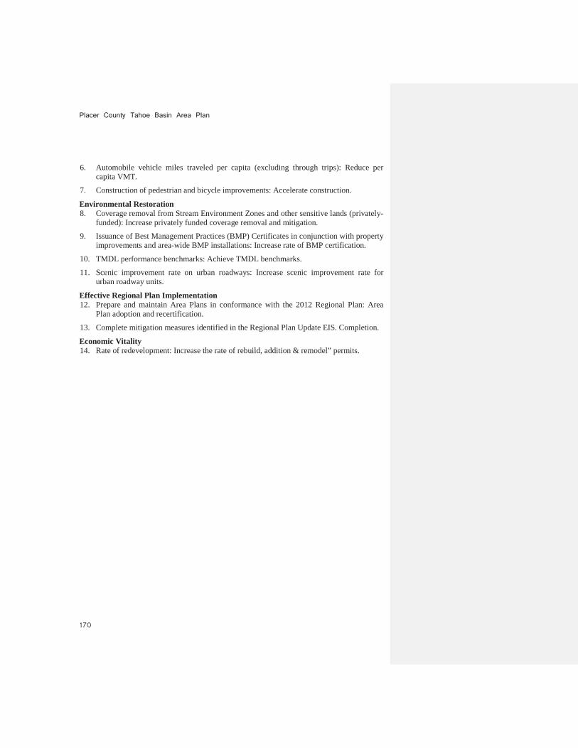
6. Automobile vehicle miles traveled per capita (excluding through trips): Reduce per capita VMT.
7. Construction of pedestrian and bicycle improvements: Accelerate construction.
Environmental Restoration8. Coverage removal from Stream Environment Zones and other sensitive lands (privately-
funded): Increase privately funded coverage removal and mitigation.
9. Issuance of Best Management Practices (BMP) Certificates in conjunction with property improvements and area-wide BMP installations: Increase rate of BMP certification.
10. TMDL performance benchmarks: Achieve TMDL benchmarks.
11. Scenic improvement rate on urban roadways: Increase scenic improvement rate for urban roadway units.
Effective Regional Plan Implementation12. Prepare and maintain Area Plans in conformance with the 2012 Regional Plan: Area
Plan adoption and recertification.
13. Complete mitigation measures identified in the Regional Plan Update EIS. Completion.
Economic Vitality14. Rate of redevelopment: Increase the rate of rebuild, addition & remodel” permits.