Parsons Creek Aggregates Project
44
Parsons Creek Aggregates Project APPENDIX 1: TERMS OF REFERENCE AND CONCORDANCE TABLE
Transcript of Parsons Creek Aggregates Project
Parsons Creek Aggregates Project
APPENDIX 1: TERMS OF REFERENCE AND CONCORDANCE TABLE
Parsons Creek Aggregates Project
FINALTERMS OF REFERENCE
Northern Region
#111 Twin Atria 4999 98 Ave Edmonton AB T6B 2X3
Telephone: (780) 427-5828 Fax: (780) 427-9102 Web: www.environment.gov.ab.ca
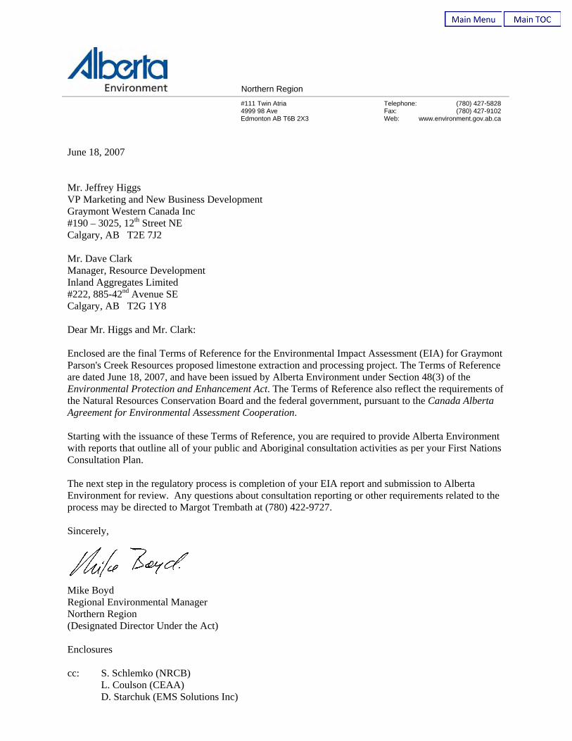
June 18, 2007 Mr. Jeffrey Higgs VP Marketing and New Business Development Graymont Western Canada Inc #190 – 3025, 12th Street NE Calgary, AB T2E 7J2 Mr. Dave Clark Manager, Resource Development Inland Aggregates Limited #222, 885-42nd Avenue SE Calgary, AB T2G 1Y8 Dear Mr. Higgs and Mr. Clark: Enclosed are the final Terms of Reference for the Environmental Impact Assessment (EIA) for Graymont Parson's Creek Resources proposed limestone extraction and processing project. The Terms of Reference are dated June 18, 2007, and have been issued by Alberta Environment under Section 48(3) of the Environmental Protection and Enhancement Act. The Terms of Reference also reflect the requirements of the Natural Resources Conservation Board and the federal government, pursuant to the Canada Alberta Agreement for Environmental Assessment Cooperation. Starting with the issuance of these Terms of Reference, you are required to provide Alberta Environment with reports that outline all of your public and Aboriginal consultation activities as per your First Nations Consultation Plan. The next step in the regulatory process is completion of your EIA report and submission to Alberta Environment for review. Any questions about consultation reporting or other requirements related to the process may be directed to Margot Trembath at (780) 422-9727. Sincerely,
Mike Boyd Regional Environmental Manager Northern Region (Designated Director Under the Act) Enclosures cc: S. Schlemko (NRCB) L. Coulson (CEAA) D. Starchuk (EMS Solutions Inc)

FINAL TERMS OF REFERENCE
ENVIRONMENTAL IMPACT ASSESSMENT (EIA) REPORT
FOR THE PROPOSED
PARSONS CREEK RESOURCES PROJECTA Limestone Quarry
ISSUED BY: Alberta Environment
DATE: June 18, 2007
TABLE OF CONTENTSPAGE
1. INTRODUCTION...............................................................................................................................11.1. Parsons Creek Resources and Scope of Environmental Impact Assessment (EIA) Report ....11.2. Public Consultation..................................................................................................................1
2. PROJECT OVERVIEW ....................................................................................................................1
3. REGULATORY AND PLANNING FRAMEWORK .....................................................................2
4. PROJECT DESCRIPTION AND MANAGEMENT PLANS.........................................................24.1. Project Need.............................................................................................................................24.2. Project Components and Site Selection ...................................................................................34.3. Water Supply, Water Management and Wastewater Management .........................................34.4. Air Emissions Management .....................................................................................................44.5. Chemical Handling and Waste Management...........................................................................44.6. Infrastructure, Utilities and Transportation .............................................................................54.7. Environmental Management System .......................................................................................54.8. Conservation and Reclamation ................................................................................................54.9. Participation in Regional Cooperative Efforts.........................................................................6
5. ENVIRONMENTAL ASSESSMENT AND CUMULATIVE EFFECTS ASSESSMENT ..........65.1. Basic Information Requirements for the Environmental Assessment .....................................75.2. Study Area(s) ...........................................................................................................................75.3. Land Use and Access to Public Lands.....................................................................................75.4. Air Quality ...............................................................................................................................8
5.4.1 Greenhouse Gas Emissions....................................................................................95.4.2 Climate Change......................................................................................................9
5.5. Noise ........................................................................................................................................95.6. Terrestrial and Aquatic Ecosystems.......................................................................................10
5.6.1 Geology, Soils, Terrain........................................................................................105.6.2 Vegetation............................................................................................................105.6.3 Wildlife ................................................................................................................115.6.4 Biodiversity..........................................................................................................125.6.5 Groundwater ........................................................................................................125.6.6 Surface Water ......................................................................................................125.6.7 Fisheries and Aquatic Resources.........................................................................13
6. ENVIRONMENTAL MONITORING............................................................................................14
7. PUBLIC HEALTH AND SAFETY .................................................................................................14
8. HISTORICAL RESOURCES..........................................................................................................15
9. TRADITIONAL LAND USE ...........................................................................................................15
10. SOCIO-ECONOMIC FACTORS ...................................................................................................15
11. PUBLIC CONSULTATION REQUIREMENTS ..........................................................................16

1. INTRODUCTION1.1. Parsons Creek Resources and Scope of Environmental Impact Assessment (EIA)
ReportThe purpose of this document is to identify for the public and Parsons Creek Resources, aJoint Venture of Graymont Western Canada Inc. and Inland Aggregates Limited (ParsonsCreek Resources), the information required by provincial government agencies for anEnvironmental Impact Assessment (EIA) report with respect to the proposed Parsons CreekResources Project (A Limestone Quarry) on Metallic and Industrial Mineral Lease9404120901 in Township 90-9-W4M in the Regional Municipality of Wood Buffalo,located between Highway 63 and the Athabasca River just north of the For McMurrayUrban Service Area.
Parsons Creek Resources will prepare and submit an EIA report to describe theenvironmental effects of its proposed Parsons Creek Resources Project (the Project) andassociated activities related to the Project. Parsons Creek Resources is responsible for thepreparation of the EIA report and related applications. The final submission will be basedupon these Terms of Reference and issues raised during the public consultation process.
The EIA report will include a glossary of terms and a list of abbreviations to assist thereader in understanding the material presented. The EIA report will include tables thatcross-reference the report to the EIA Terms of Reference and to any current applicationssubmitted pursuant to the Environmental Protection and Enhancement Act (EPEA) and theWater Act.
The EIA report will be prepared in accordance with the requirements prescribed under theEPEA, and any federal legislation, which may apply to the Project. It will form part ofParsons Creek Resources’ application to the Natural Resources Conservation Board(NRCB).
1.2. Public ConsultationParsons Creek Resources must provide the public with opportunities to obtain informationabout the Project, and to identify their concerns. The public consultation program is tocommunicate with those members of the public who may be affected by the Project and toprovide them with an opportunity to participate in the Environmental Assessment process.The EIA report will document public concerns or suggestions and demonstrate how theyhave been addressed.
2. PROJECT OVERVIEWProvide a corporate profile, clearly outlining the ownership structure of the Corporation, anoverview of the Project, the key environmental, resource management and economic issues that areimportant for a public-interest decision and the results of the Environmental Assessment. Describewho will be responsible for the development, management and operation of the Project. Indicatewhat, if any, environmental management system the corporation responsible for the development,management and operation of the Project will follow.

- 2 -
3. REGULATORY AND PLANNING FRAMEWORKIdentify the legislation, policies, approvals and current multi-stakeholder planning initiativesapplicable to the review of the Project. Discuss the primary focus of each regulatory requirement,such as resource allocation, environmental protection, land use development and the elements ofthe Project that are subject to each regulatory requirement. List the major components of theProject that will be applied for and constructed under the EPEA, Water Act and the Public LandsAct.
Address other regulatory approvals that exist or will be required for the Project under provincial,municipal and applicable federal government requirements.
Discuss any regulatory systems that apply to the Project, such as solid waste, air pollutionclassifications [e.g., National Pollutant Release Inventory (NPRI), Accelerated Reduction andElimination of Toxics (ARET), Priority Substances List (PSL1), PSL2], land use zones, wildlifemanagement areas and forest management areas.
Address the relevant parts of the Fort McMurray Athabasca Oil Sands Integrated Resource Plan(IRP) that have been reviewed and considered in the preparation of the EIA report.
4. PROJECT DESCRIPTION AND MANAGEMENT PLANSThe scope and detail of the project description information shall be sufficient to allow quantitativeassessment of the environmental consequences.
Describe the project components including infrastructure and activities at the anticipateddevelopment stages (e.g., construction, operations, decommissioning and reclamation), projectschedule and timing of the key construction and operational activities. Discuss the site alternativesconsidered, the potential effects that activities and infrastructures may have on the environmentand the natural resources to be used for the Project. Outline the management plans to minimize thedischarge of pollutants, manage wastes, reclaim disturbed lands and water bodies, optimizeresource use and monitor effects.
4.1. Project NeedDiscuss the need for the Project, the technical and operating systems considered for theproject and the rationale for those ultimately selected for the application. Include adiscussion of the implications of not proceeding with the Project or delaying the Project.Address the following:a) an analysis of the alternatives considered for carrying out the Project, including the
environmental effects of utilizing these alternative, with the criteria and rationale forselecting the proposed option;
b) how a balance among environmental, conservation , resource recovery and economicgoals will be achieved through planning and preliminary design, highlighting anyareas where planning focused on one goal to the exclusion of others;
c) identify whether additional development phases will be considered at this site in thefuture and how the proposed plans for the Project takes this into consideration; and
d) contingency plans if selected major components of the Project prove to be unfeasible.
- 3 -
4.2. Project Components and Site SelectionDescribe the development of the site, and the nature, size, location and duration of thecomponents of the Project including, but not limited to the following:a) the quarry areas;b) the proposed annual production required to support the life of the Project;c) the design capacities of the Project;d) the process components of the development focusing on material inputs and outputs
including products, fuels, feedstocks, utility requirements (e.g., electricity and naturalgas). As appropriate, provide material balances (energy and water), flow diagramsand descriptions of the processes to be used. Indicate any shared facilities withexisting developments at the site;
e) water control facilities and temporary structures;f) buildings and infrastructure, transportation, utilities and access routes;g) major operational components of the Project and a project layout showing the
linkages among these components;h) a project development schedule;i) the total land area disturbed annually and during the life of the Project;j) how Parsons Creek Resources has incorporated community information into the
project design and mitigation;k) the location, area and volume of merchantable timber to be removed and the timing;l) the process and factors (including exploration activities) that were considered in
evaluating and delineating the limits of the limestone and aggregate reserves anddiscuss how this might affect initial and future pit development and disturbanceactivities;
m) the rationale for selecting the proposed site and how technical, geotechnical andenvironmental criteria and stakeholder input were considered in decision-making;
n) potential cooperative ventures with oil sands operators and other resource users(mineral and forestry) to maximize the efficiency for the Project and/or minimize theenvironmental impact of the Project; and
o) a development plan of appropriate scale (including legal land description) showingthe progression of project development, debris disposal, overburden and soil stockpileareas, storage areas and other site improvements required in support of thedevelopment.
Provide maps of appropriate scale (including legal description) showing:a) all existing surface leases and clearings and illustrate how these will be used or
affected by the project development;b) all existing seismic lines, access roads and other linear corridors (e.g., pipelines,
utility corridors, traplines, etc.);c) the location of the development relative to all terrestrial components (e.g., soils,
topography, watercourses, vegetation, wildlife habitat, watersheds, wetlands, etc.).
4.3. Water Supply, Water Management and Wastewater ManagementThe EPEA and Water Act require approvals for the use of surface and/or subsurface waterincluding water for processing, discharge of processing water and surface runoff from thesite into a surface waterbody. Identify development activities that may affect surface water

- 4 -
or groundwater including water treatment processes and chemicals added. Identify thepurpose of any drilled well(s).
Provide a water supply and water management plan to discuss the following:a) site runoff and containment, erosion control, groundwater protection, muskeg
dewatering, quarry pit dewatering and disposal and/or treatment of wastewater;b) how water management facilities, will adequately protect quarry operations from
precipitation events (including significant open water flood and ice jam occurrences)and address the application of The Canadian Dam Association, Dam SafetyGuidelines.;
c) permanent or temporary alterations or realignments to waterbodies and wetlands;d) process, sanitary and potable water requirements during normal operations and
emergencies;e) water sources to be used including volumes expected from each source and location
of diversion;f) the application of Alberta Environment’s Groundwater Evaluation Guideline for non-
saline groundwater sources and dewatering activities; andg) any water minimization considerations including plans to ensure efficient water use
including any variability in water quantity required on an annual basis and duringconstruction.
4.4. Air Emissions ManagementIdentify and describe project emission sources, including point and area sources, slashburning sources, mobile sources and fugitive emissions. Estimate the range of emissionsfrom all sources identified above for normal and worst-case conditions. Discuss thefollowing from a management perspective:a) potential odorous or visual emissions;b) probable deposition areas and effects to soils, vegetation and waterbodies;c) the emission control technologies proposed for the Project in the context of best-
available technologies; andd) monitoring programs that will be implemented to assess air quality and the
effectiveness of mitigation measures implemented during project development andoperation.
4.5. Chemical Handling and Waste ManagementProvide information on the character and volume of any materials used or solid or liquidwaste material generated or stored on-site at the Project including a plot plan for on-sitedisposal areas that might be established. Describe strategies to minimize the potential foraccidental release or spills and mitigation plans.
Identify the location and amount of all on-site storage of chemicals. Explain containmentand environmental protection measures for handling chemicals, including explosives.

- 5 -
4.6. Infrastructure, Utilities and TransportationDescribe the project infrastructure requirements, existing and proposed, including, but notlimited to, the following:a) haul roads routing and design, limestone crushing and handling facilities, stockpile
sites, and transport facilities;b) volumes, timing (where applicable) and types of traffic associated with the movement
of goods, services and personnel to and from the Project during the construction,operation and reclamation phases;
c) the impact of increased vehicle traffic on the existing roadway system consideringother existing and planned developments in the region;
d) road access to and within the Project Area, the need to upgrade existing or constructnew roads and the impacts of any new road construction or road improvements ifrequired;
e) how Parsons Creek Resources plans to address the provincial transportationdepartment’s concerns with regards to access to borrow materials, truck staging areasand the provision of adequate buffers to protect the future Highway 63 right-of-way;
f) the result of consultation with the local transportation authorities and otherstakeholders, including transportation studies that are underway or planned. Indicatehow local community needs have been considered in access management; and
g) how public access to, or within the Project will be managed during differentdevelopment phases of the Project.
4.7. Environmental Management SystemOutline the elements of Parsons Creek Resources’ environmental, health and safetymanagement system and discuss how it will be integrated into the Project. Providecorporate policies and procedures, spill and air emission reporting procedures andemergency response plans. Describe new monitoring intiatives that may be required as aresult of the Project and outline Parsons Creek Resources’ commitment to adaptiveenvironmental management.
4.8. Conservation and ReclamationProvide a conceptual Conservation and Reclamation Plan (C&R Plan) for the Project,including:a) the objectives for reclamation, proposed end land use objectives and other factors
necessary for C&R Plan implementation including:i) consideration of pre-development information with respect to land capability,
vegetation, forest productivity, wildlife, aesthetics and land use resources;ii) project development phasing;iii) soil and reclamation material salvage, soil storage areas and soil handling
procedures;iv) the suitability and availability of soils within the project footprint for
reclamation. Outline the criteria to be used in salvaging soils for reclamationand provide a soil balance for the Project;
v) soil replacement types, depths and volumes;vi) re-establishment of a self-sustaining natural appearing topography, drainage
and surface watercourses;
- 6 -
vii) closure planning and reclamation activities/sequencing for each phase ofdevelopment;
viii) post-development reforestation and forest productivity with informationrequired for inclusion into forest management plans for the area;
ix) post-development capability for all uses, including traditional uses (traditionalvegetation and wildlife species);
x) the species that will be used for revegetation and discuss the use of nativespecies in the reclamation program;
b) how the land will be returned to pre-disturbed equivalent capability having regard forregulatory requirements and end land use;
c) references to examples of demonstrated success with respect to proposed reclamationtechniques, where applicable;
d) operational or mitigative procedures that may be required to ensure that water qualityand quantity in the Athabasca River is not impacted as a result of the Project;
e) potential collaborative reclamation procedures considered among Parsons CreekResources and any other developers should the Project Area be subject to more thanone land use, and review any discussions that Parsons Creek Resources has had withthese other developer(s); and
f) detailed supporting information demonstrating how the integrity of the reclaimedquarry can be protected during significant open water flooding and ice jamoccurrences along the Athabasca River.
4.9. Participation in Regional Cooperative EffortsDiscuss Parsons Creek Resources’ current and planned involvement in regional cooperativeefforts that address environmental and socio-economic issues associated with regionaldevelopment, including the Cumulative Environmental Management Association (CEMA),the Wood Buffalo Environmental Association (WBEA), the Regional Aquatics MonitoringProgram (RAMP) and their working groups. Include Parsons Creek Resources’participation in regional air, water and other environmental monitoring programs, healthstudies, research, TEK and socio-economic studies.
Describe how Parsons Creek Resources will contribute to the effective design andimplementation of proposed mitigation measures, monitoring programs and researchprograms within these regional cooperative efforts.
5. ENVIRONMENTAL ASSESSMENT AND CUMULATIVE EFFECTSASSESSMENTDefine assessment scenarios, including:a) a Baseline Scenario, which includes existing environmental conditions, existing and
approved projects or activities;b) an Application Scenario, which includes the Baseline Scenario plus the Project; andc) a Cumulative Effects Assessment (CEA) Scenario, which includes the Application Scenario
(Baseline Scenario plus Project) plus planned projects or activities.
Note: For the purposes of defining assessment scenarios, “approved” means approved by anyfederal, provincial or municipal regulatory authority, and “planned” means any project or activity

- 7 -
that has been publicly disclosed prior to the issuance of the Terms of Reference or up to sixmonths prior to the submission of the Project Application and the EIA report, whichever is mostrecent.
For the cumulative effects assessment, each of the environmental, social, economic, health, andland use components will be evaluated, assessed and discussed where combined effects couldreasonably be considered to result due to development of the Project in combination with otherexisting, approved and planned projects in the region. Include industrial projects as well asactivities associated with other land uses and infrastructure.
5.1. Basic Information Requirements for the Environmental AssessmentThe EIA report will include the following basic environmental information:a) quantitative and qualitative information about the environment and ecological
processes in the Study Area(s), including relevant information presented in previousenvironmental assessments;
b) information about the human activities in the Study Area(s); e.g., land disturbance,discharges of substances, changes to access status and effects that the Project mayhave on the present and future capacity of renewable resources;
c) a discussion of the process employed to classify and evaluate the effects associatedwith the Project;
d) management plans to prevent, minimize or mitigate adverse effects and to monitorand respond to expected or unanticipated conditions; and
e) a discussion of residual effects.
Where models are used, document any assumptions used in the EIA report to obtainpredictions. Clearly identify the data used in the modeling including sources of error andrelative accuracy, and identify the limitations of the models and steps taken to improve theaccuracy. Describe the applicability and reasons for using a particular model,
5.2. Study Area(s)Define and provide the rationale for the spatial and temporal boundaries for the StudyArea(s) used for the assessment. Discuss the selection criteria used to determine the StudyArea(s), including information sources and assessment methods. The spatial boundariesshall include all areas where measurable changes in the environment may be caused by theProject regardless of any political boundaries.
5.3. Land Use and Access to Public LandsDescribe baseline land use and access to public lands in the Study Area(s) and discuss theimpacts on these for each scenario. Identify/discuss:a) the existing land uses and discuss the potential impact(s) of the Project to these land
uses. Describe strategies to mitigate the impact(s);b) any land use policies and resource management initiatives that pertain to the Project
Area and discuss how the Project will be consistent with these policies;c) any unique sites or rare features within the Project Area that may be impacted by the
Project. Describe strategies to mitigate these impact(s);
- 8 -
d) potential changes in land use, land management, other industrial uses in the region,and recreational uses that may result from the Project;
e) how public access to the development area and adjacent Crown lands will bemanaged during the development phases and the need for access management;
f) the impact of the proposed development and reclamation on commercial forestharvesting;
g) the potential for increased access into the area that may be associated with projectdevelopment and its impact on other resources and resource use such as increasedhunter, off-highway vehicle and other recreational users;
h) the results of consultation with other industry operators and Aboriginal communitiesregarding access to the Project Area; and
i) the impact project development may have on any mineable oil sands resources in theProject Area. Discuss how project development has been coordinated with adjacentdevelopment(s). Discuss any limitations that the Project may have on other potentialor approved developments.
5.4. Air QualityDiscuss baseline ambient air quality conditions. Review current emission sources anddiscuss changes as a result of anticipated future industrial development within the EIAStudy Areas. Consider emission point sources as well as fugitive emissions. Identifycomponents of the Project that will affect ambient air quality from a local and regionalperspective by doing the following:a) discuss appropriate air quality parameters such as oxides of nitrogen (NOx), visibility,
and particulates (road dust, PM10 and PM2.5);b) estimate ground-level concentrations via modeling of appropriate air quality
parameters. Discuss any expected changes to particulate deposition patterns. Includea comparison of modeled concentrations to recent monitoring results, as appropriate;
c) identify the potential for reduced air quality (including odours and visibility) resultingfrom the Project and discuss any implications of the expected air quality forenvironmental protection and public health. Provide this information specifically forcommunities and sensitive receptors located close to the Project, as appropriate;
d) describe air quality impacts resulting from the Project, and their implications forother environmental resources, including vegetation resources, and water and soilquality;
e) for acid deposition modeling, provide deposition data predictions includingmagnitude and location of predicted maximum levels for all areas within the 0.25keq/ha/yr and 0.17 keq/ha/yr Potential Acid Input (PAI) isopleth, including analysisof PAI deposition levels consistent with the CEMA Acid Deposition ManagementFramework;
f) complete modeling and present results in accordance with Alberta Environment's AirQuality Modeling Guidelines (March 2003);
g) describe how air quality impacts resulting from the Project will be mitigated and anymonitoring programs to be implemented for assessing air quality or the effectivenessof mitigation measures;
h) discuss the use of ozone depleting substances;
- 9 -
i) describe meteorological conditions including wind speed, direction and inversionsinsofar as they affect dispersion and disposition; and
j) estimate the quantity released of any compounds regulated under the NPRI.
5.4.1 Greenhouse Gas EmissionsProvide the following:a) the expected annual and total greenhouse gas (GHG) emissions over the
construction, operation and decommissioning phases of the Project;b) the Project’s contribution to total provincial and national GHG emissions on an
annual basis;c) the intensity of GHG emissions per unit of product produced and how it
compares with similar projects and technology performance;d) how the project design and GHG management plans take into account the need
for continuous improvement with respect to GHG emissions and the planAlbertans and Climate Changes; Taking Action; and
e) Graymont Western Canada Inc and Inland Aggregates Limited overall GHGmanagement plans, any plans for the use of offsets (nationally orinternationally) and the expected results of implementing the plans.
5.4.2 Climate ChangeDiscuss the following:a) climate change and the local and/or regional, inter-provincial/territorial
changes to environmental conditions resulting from climate conditions,including trends and projections where available (in accordance with theguidance document Incorporating Climate Change Considerations inEnvironmental Assessment: General Guidance for Practitioners);
b) stages or elements of the Project that are sensitive to changes or variability inclimate parameters. Discuss what impacts the change to climate parametersmay have on elements of the Project that are sensitive to climate parameters;and
c) the adaptability of the Project in the event the region’s climate changes.Discuss any follow-up programs and adaptive management considerations.
5.5. NoiseProvide baseline noise levels. Discuss;a) the results of a noise assessment as specified by EUB Directive 038 Noise Control
(or the most recent version of the document) including: andi. an estimate of the potential for increased noise resulting from the Project;ii. identification of potentially affected people and wildlife; andiii. the implications of any increased noise levels.
b) mitigation options, considering such factors as intensity, magnitude, frequency,duration and time of day.
- 10 -
5.6. Terrestrial and Aquatic Ecosystems5.6.1 Geology, Soils, Terrain
Describe the following:a) the baseline conditions of bedrock, bedrock topograpy and surficial geology,
soils and terrain in the Study Area(s). Where appropriate, use maps, cross-sections and figures to illustrate these features;
b) the soil types and their distribution in the Project Development Area and StudyAreas. Provide an ecological context to the soil resource by supplying a soilsurvey report and maps; and
c) changes to these baseline conditions that may occur due to development of theProject.
5.6.2 VegetationDescribe and map vegetation communities in the EIA Study Area(s), using asappropriate, the Alberta Vegetation Inventory (AVI) Standards Manual 2.1, The FieldGuide to Ecosites of Northern Alberta (Beckingham and Archibald, 1996), and theAlberta Wetland Inventory Standards Manual (AWI) Version 1.0. For eachassessment scenario, discuss the following:a) ecosite phases based on their potential to support rare plant species, old growth
forests or other communities of restricted distribution (e.g., fens).b) the species associated with each ecosite phase and address:
i) special status plant species (rare, threatened or endangered);ii) the importance of the size, distribution and variety of vegetation units
assessed in habitat suitability indices for wildlife and riparian habitat;iii) the importance of peatland and wetland species and landscape units for
local and regional habitat, sustained forest growth and the hydrologicregime. Determine the rarity or abundance of peatlands and wetlandsfrom local and regional perspectives; and
iv) the availability of plants used for food, medicinal and cultural purposes;c) the sensitivity to disturbance of each of the vegetation communities and their
ability to be restored, as well as the techniques used to estimate sensitivity todisturbance and reclamation (e.g., sensitivity to air emissions);
d) the nature, size, distribution and timing of changes to vegetation communities,including the effects of air emissions;
e) the area of productive and non-productive forest land base that will bedisturbed and taken out of production during the life of the Project. Describeplans for the return of pre-disturbance forest ecosites by area, species andproductivity;
f) introduction of non-native plant species on native species composition andpotential plant changes to communities;
g) the extent to which existing seismic lines, and linear corridors and otherexisting disturbances will be used for project facilities;
h) the area and distribution of all vegetation communities existing prior to theproject development and expected at closure; and
i) plans to mitigate the adverse effects of site clearing and other developmentactivities and operations on vegetation, including rare plant species.
- 11 -
5.6.3 WildlifeDescribe existing wildlife resources and their use of habitats in the Study Area(s).Document the anticipated changes to wildlife in the Study Area(s) under eachscenario. Specifically:a) discuss the criteria and process used in the selection of wildlife indicator
species, including those listed by Alberta Fish and Wildlife (at risk, may be atrisk and sensitive species in the General Status of Alberta Wild Species 2000)and COSEWIC (endangered, threatened, special concern in Canadian Speciesat Risk 2002);
b) identify species composition, distribution, relative abundance, seasonalmovements, movement corridors, habitat requirements, key habitat areas, andgeneral life history in the Study Area(s);
c) include current field data, using recognized sampling protocols, for the specieschosen for evaluation in the EIA report;
d) evaluate potential adverse impacts on, habitat availability, quality, andeffective wildlife use of habitat due to the Project
e) describe the spatial and temporal changes to habitat and to wildlife distribution,relative abundance, movements, and the potential to return the area to pre-disturbed wildlife habitat conditions, including:i) anticipated effects on wildlife as a result of changes to air and water,
including both acute and chronic effects on animal health;ii) anticipated effects on wildlife as a result of project activity; andiii) anticipated effects on wildlife due to improved or altered access into the
area (e.g., vehicle collisions with wildlife, obstructions to daily orseasonal movements, and hunting mortality during operations and afterproject closure);
f) discuss the protection of riparian habitats, interconnectivity of such habitat, andthe movement by wildlife species using the habitat;
g) indicate what measures will be taken to prevent habituation of wildlife, thepotential for human-wildlife encounters and consequent destruction of wildlife(e.g., black bears);
h) describe the effects of the Project on those wildlife species selected forevaluation. Identify residual impacts and discuss their significance at the localand regional scales; and
i) provide a strategy and mitigation plan to minimize impacts on habitat andwildlife populations through the life of the Project and to return productivewildlife habitat to the area, considering:i) habitat enhancement measures in adjacent undisturbed areas, and a
schedule for the return of habitat capability to areas impacted by theProject;
ii) consistency of the plan with applicable regional, provincial and federalwildlife habitat objectives and policies; and
iii) monitoring programs to assess wildlife impacts from the Project and theeffectiveness of mitigation strategies and habitat enhancement measures.
- 12 -
5.6.4 BiodiversityDescribe ecosystem characteristics in the Study Area(s), and explain the significanceof potential project impacts from the perspective of biodiversity, includingconsideration of potential local and regional project impacts on:a) ecosystem fragmentation;b) habitat diversity and quantity; andc) species diversity.
5.6.5 GroundwaterDescribe the groundwater regime in the Study Area(s), using map(s), cross section(s)and/or other drawings as appropriate. Discuss the following:a) the lithology, stratigraphic and structural continuity, thickness, hydraulic
properties, major groundwater features (aquifers, aquitards, aquicludes),groundwater flow direction and velocity, and groundwater quality of thegeologic units in the Study Area(s);
b) historical and current hydrogeological investigations, including methodologyand results;
c) the potential for hydraulic connection between geological zones affected by theProject (e.g., quarry zones, groundwater production and the land surface);
d) parameters to be used as indicators of potential aquifer contamination;e) the potential for changes in the groundwater regime and the effects of these
changes that may arise from the Project, including:i) changes in groundwater quality, vertical gradients and aquifer recharge
rates;ii) changes resulting from any proposed diversion;iii) an inventory of all groundwater users (field verified survey), and
potential water use conflicts and proposed resolutions;v) the effect(s) of groundwater withdrawal and/or surficial dewatering and
their implications for other environmental resources, including habitatdiversity and quantity, surface water quality and quantity, vegetation,wetlands and soil saturation;
f) the inter-relationship of the groundwater to the surface water and the potentialfor impacts on water quality and quantity due to recharge from and discharge tolocal waterbodies and wetlands; and
g) a conceptual plan and implementation program for the protection ofgroundwater resources, including the following:i) the early detection of potential contamination and remediation planning;ii) groundwater remediation options in the event that adverse effects are
detected; andiii) monitoring the sustainability of groundwater production or dewatering
effects.
5.6.6 Surface WaterDiscuss baseline hydrological conditions in the Study Area(s). Provide a waterbalance for the Study Area that includes inputs from precipitation and surface waterflow (including runoff) and outputs from evapotranspiration, seepage to groundwater
- 13 -
and surface water outflow (including runoff). Identify project activities that mayaffect surface water quality and quantity during all stages of the Project andmitigation measures to prevent or minimize potential impacts, including:a) appropriate surface water quality and hydrological parameters, their seasonal
variations (provide hydrographs as appropriate) and relationships betweenflows and water quality as they pertain to the Project;
b) the project components or activities during construction, operation andreclamation that have the potential to affect surface water quality and flows,including;i) any changes in water quality and quantity resulting from the Project that
may indicate a potential adverse effect or non-compliance withappropriate guidelines;
ii) the significance of any impacts on water quality and quantity andimplications to aquatic resources (e.g., biota, biodiversity and habitat);
iii) the effect on water quality and quantity in surface waterbodies due to thechange in groundwater discharge; and
iv) the significance of any seasonal change to surface water flows;c) any activities to be conducted in or near waterbodies and describe the
connection(s) between these activities and the affected waterbodies;d) the selection of monitoring locations, and the integration of these sites into an
overall aquatic assessment and monitoring program. Identify any cooperativemonitoring and assessment initiatives; and
e) any aspect of the Project that is likely to affect a navigable waterway.
5.6.7 Fisheries and Aquatic ResourcesDescribe existing fisheries and aquatic resources, their use and potential use ofhabitats in the Study Area(s). Document the anticipated changes to the fisheries andaquatic resources in the Study Area(s). Specifically:a) Identify fisheries species composition, distribution, relative abundance,
seasonal movements, habitat requirements, key habitat areas, and general lifehistory in the Study Area(s);
b) describe the spatial and temporal changes to habitat and to fish distribution,relative abundance, movements, including:i) anticipated effects on fisheries as a result of changes to air and water,
including both acute and chronic effects on fish health; andii) anticipated effects on fisheries due to improved or altered access into the
area (e.g., increased fishing pressure during operations and after projectclosure);
c) discuss the use of setbacks to provide for the protection of riparian habitats,fish and aquatic habitat and evidence to support their effectiveness. Identifyany construction, operation and reclamation activities that may affect aquaticresources. Indicate whether blasting could harm aquatic resources;
d) identify plans proposed to offset any loss in the productivity of fish habitats.Indicate how environmental protection plans address applicable provincial andfederal policies on fish habitat including the development of a “No Net Loss”fish habitat objective; and
- 14 -
e) describe mitigation to prevent adverse impacts; and monitoring programs, asapplicable, to assess fisheries and aquatic resource impacts from the Projectand the effectiveness of mitigation strategies.
6. ENVIRONMENTAL MONITORINGDescribe any additional environmental monitoring, not already described elsewhere, that ParsonsCreek Resources will undertake to manage predicted effects and improve environmental protectionstrategies. Describe any proposed mitigation plans not already described, and identify anyanticipated residual effects.
7. PUBLIC HEALTH AND SAFETYDescribe those aspects of the Project that may have implications for public health or the deliveryof health services. Determine whether there may be implications for public health arising from theProject. Specifically:a) identify and discuss the data and methods Parsons Creek Resources used to assess impacts
of the Project on human health and safety;b) assess the potential health implications of the compounds that will be released to the
environment from the proposed operation in relation to exposure limits established toprevent acute and chronic adverse effects on human health;
c) identify the human health impact of the potential contamination of country foods and naturalfood sources taking into consideration all project activities;
d) provide information on samples of selected species of vegetation known to be consumed byhumans;
e) discuss the potential to increase human exposure to contaminants from changes to waterquality, air quality and soil quality taking into consideration all project activities;
f) document any health concerns identified by Aboriginal stakeholders due to the impacts ofthe Project specifically on their traditional lifestyle. Determine the potential impact of theProject on the overall health of Aboriginal stakeholders and identify possible mitigationstrategies;
g) assess cumulative health effects to receptors that are likely to result from the Project incombination with other existing, approved and planned projects;
h) identify, as appropriate, the anticipated follow-up work, including regional cooperativestudies. Identify how such work will be implemented and coordinated with ongoing air, soiland water quality initiatives;
i) identify and discuss the potential health and safety impacts due to higher regional trafficvolumes and the increased risk of accidental leaks and spills;
j) document the health and safety concerns raised by stakeholders during consultation on theProject;
k) provide a summary of Parsons Creek Resources’ emergency response plan and discussmitigation plans to ensure workforce and public safety during pre-construction,construction, operation and reclamation of the Project. Include prevention and safetymeasures for wildfire occurrences, accidental release or spill of chemicals to theenvironment and failures of structures retaining water or fluid wastes;
l) describe how local residents will be contacted during an emergency and the type ofinformation that will be communicated to them; and
- 15 -
m) describe the existing agreements with area municipalities or industry groups such as safetyco-operatives, emergency response associations and municipal emergency responseagencies.
8. HISTORICAL RESOURCESDescribe those aspects of the Project that may have implications for historical resources andprovide the following:a) a general overview of the results of any previous historic resources studies that have been
conducted in the Study Area(s) as defined within the Historical Resources Act;b) details of the consultation with the Heritage Resources Management Branch with respect to
historical resources;c) a summary of the results of the Historical Resources Impact Assessment;d) details of the participation of Aboriginal peoples in the Historical Resources Impact
Assessment;e) details of any stakeholder concerns with respect to the development of the Project based on
the historical significance of the Local Study Area; andf) an outline of the historical resources management program and schedule of field
investigations that may be required to assess and mitigate the effect of the Project onhistorical resources pursuant to the Historical Resources Act;
9. TRADITIONAL LAND USEDescribe the following:a) historical and current traditional use of the Study Area(s) by First Nations and Métis,
including fishing, hunting, trapping, plant harvesting and any other traditional or culturaluses as identified by Aboriginal groups;
b) Parsons Creek Resources’ consultation with Aboriginal stakeholders to determine theirconcerns regarding project development on traditional use of the Study Area(s); and
c) the effects of the Project on First Nations and Métis traditional land use and culture, andidentify possible mitigation strategies.
d) how Traditional Environmental Knowledge (TEK) will be incorporated into theEnvironmental Impact Assessment; and
e) how TEK will be utilized during operations i.e. using TEK in reclamation plans.
Provide map(s) of appropriate scale(s) showing the traditional land use areas of Aboriginalpeoples.
10. SOCIO-ECONOMIC FACTORSDiscuss the following:a) socio-economic conditions before and after project development, including the number of
people who may be affected, population changes, local employment, local procurement,traffic and existing local and regional services including existing social agencies, educationinitiatives, training programs and business development initiatives;
b) the impacts of the proposed Project on the availability of affordable housing and the qualityof health care services. Identify and discuss the mitigation plans that will be undertaken toaddress these issues. Provide a summary of any discussions that have taken place with the

- 16 -
Municipality and Regional Health Authority concerning housing availability and health careservices respectively;
c) capital investment, labour requirements, and other operating costs and revenue fromservices relating to the Project. Include an estimated breakdown of the Alberta, otherCanadian and foreign industrial benefits relating to project management and engineering,equipment and materials, construction labour. Estimate the total overall project costs andrevenues;
d) the employment and business development opportunities the Project may create and theeconomic impact in the Study Area(s), region, province and Canada;
e) Parsons Creek Resources’ Aboriginal procurement policies, and Aboriginal training andhiring policies and practices for the project;
f) Parsons Creek Resources’ policy for managing site access (e.g. hunting, fishing etc.) bycontractors during construction and employees and contractors during operations;
g) Parsons Creek Resources’ policies and programs respecting the use of local, regional,Alberta and Canadian goods and services;
h) potential project demands upon local services and infrastructure; andi) quantify local, regional and provincial economic benefits arising from the Project.
11. PUBLIC CONSULTATION REQUIREMENTSDescribe the following:a) the public consultation process implemented for the Project including the involvement of
local residents, and other key stakeholders such as oil sands operators, special interestgroups, First Nations and Métis within the Study Area(s);
b) the methods by which information was provided to the public, the type of informationprovided, and the nature of responses received including:i. where and when public meetings were held and, to the extent possible, list attendees;ii. how concerns and ideas were brought to the attention of Parsons Creek Resources and
the actions taken to address the concerns;iii. how issues and resolution of concerns were incorporated into the project
development, impact mitigation and monitoring;c) plans to maintain the public consultation process following completion of the
Environmental Assessment review to ensure that the public will have an appropriate forumfor providing their input and expressing their views on the ongoing development, operationand reclamation of the Project.
Parsons Creek Aggregates Project
CONCORDANCE TABLE
Parsons Creek Aggregates Project
Appendix 1 June 2010 Page 1
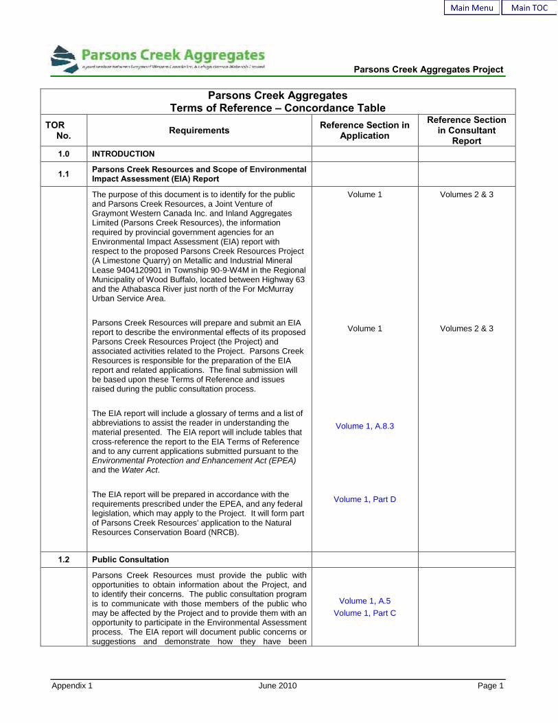
Parsons Creek AggregatesTerms of Reference – Concordance Table
TORNo. Requirements Reference Section in
Application
Reference Sectionin Consultant
Report1.0 INTRODUCTION
1.1 Parsons Creek Resources and Scope of EnvironmentalImpact Assessment (EIA) Report
The purpose of this document is to identify for the publicand Parsons Creek Resources, a Joint Venture ofGraymont Western Canada Inc. and Inland AggregatesLimited (Parsons Creek Resources), the informationrequired by provincial government agencies for anEnvironmental Impact Assessment (EIA) report withrespect to the proposed Parsons Creek Resources Project(A Limestone Quarry) on Metallic and Industrial MineralLease 9404120901 in Township 90-9-W4M in the RegionalMunicipality of Wood Buffalo, located between Highway 63and the Athabasca River just north of the For McMurrayUrban Service Area.
Parsons Creek Resources will prepare and submit an EIAreport to describe the environmental effects of its proposedParsons Creek Resources Project (the Project) andassociated activities related to the Project. Parsons CreekResources is responsible for the preparation of the EIAreport and related applications. The final submission willbe based upon these Terms of Reference and issuesraised during the public consultation process.
The EIA report will include a glossary of terms and a list ofabbreviations to assist the reader in understanding thematerial presented. The EIA report will include tables thatcross-reference the report to the EIA Terms of Referenceand to any current applications submitted pursuant to theEnvironmental Protection and Enhancement Act (EPEA)and the Water Act.
The EIA report will be prepared in accordance with therequirements prescribed under the EPEA, and any federallegislation, which may apply to the Project. It will form partof Parsons Creek Resources’ application to the NaturalResources Conservation Board (NRCB).
Volume 1
Volume 1
Volume 1, A.8.3
Volume 1, Part D
Volumes 2 & 3
Volumes 2 & 3
1.2 Public Consultation
Parsons Creek Resources must provide the public withopportunities to obtain information about the Project, andto identify their concerns. The public consultation programis to communicate with those members of the public whomay be affected by the Project and to provide them with anopportunity to participate in the Environmental Assessmentprocess. The EIA report will document public concerns orsuggestions and demonstrate how they have been
Volume 1, A.5Volume 1, Part C

Parsons Creek Aggregates Project
Appendix 1 June 2010 Page 2
Parsons Creek AggregatesTerms of Reference – Concordance Table
TORNo. Requirements Reference Section in
Application
Reference Sectionin Consultant
Reportaddressed.
2.0 PROJECT OVERVIEW
Provide a corporate profile, clearly outlining the ownershipstructure of the Corporation, an overview of the Project, thekey environmental, resource management and economicissues that are important for a public-interest decision andthe results of the Environmental Assessment. Describewho will be responsible for the development, managementand operation of the Project. Indicate what, if any,environmental management system the corporationresponsible for the development, management andoperation of the Project will follow.
Volume 1, A.1.2;Volume 1, B.11
3.0 REGULATORY AND PLANNING FRAMEWORK
Identify the legislation, policies, approvals and currentmulti-stakeholder planning initiatives applicable to thereview of the Project. Discuss the primary focus of eachregulatory requirement, such as resource allocation,environmental protection, land use development and theelements of the Project that are subject to each regulatoryrequirement. List the major components of the Project thatwill be applied for and constructed under the EPEA, WaterAct and the Public Lands Act.
Address other regulatory approvals that exist or will berequired for the Project under provincial, municipal andapplicable federal government requirements.
Discuss any regulatory systems that apply to the Project,such as solid waste, air pollution classifications [e.g.,National Pollutant Release Inventory (NPRI), AcceleratedReduction and Elimination of Toxics (ARET), PrioritySubstances List (PSL1), PSL2], land use zones, wildlifemanagement areas and forest management areas.
Address the relevant parts of the Fort McMurrayAthabasca Oil Sands Integrated Resource Plan (IRP) thathave been reviewed and considered in the preparation ofthe EIA report.
Volume 1, A.4Volume 1, A.6.4Volume 1, Part FVolume 1, Part G
Volume 2, CR #4
4.0 PROJECT DESCRIPTION AND MANAGEMENT PLANS
The scope and detail of the project description informationshall be sufficient to allow quantitative assessment of theenvironmental consequences.Describe the project components including infrastructureand activities at the anticipated development stages (e.g.,
Volume 1, A.2Volume 1, A.3
Volume 1, Part B
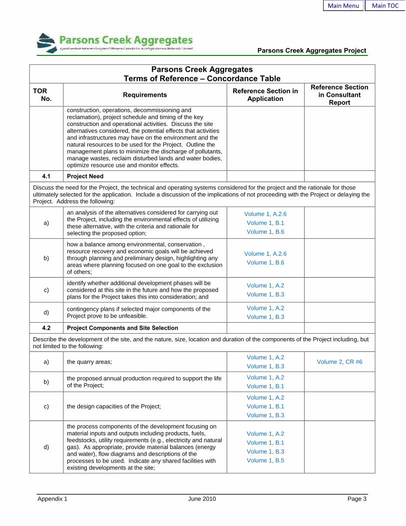
Parsons Creek Aggregates Project
Appendix 1 June 2010 Page 3
Parsons Creek AggregatesTerms of Reference – Concordance Table
TORNo. Requirements Reference Section in
Application
Reference Sectionin Consultant
Reportconstruction, operations, decommissioning andreclamation), project schedule and timing of the keyconstruction and operational activities. Discuss the sitealternatives considered, the potential effects that activitiesand infrastructures may have on the environment and thenatural resources to be used for the Project. Outline themanagement plans to minimize the discharge of pollutants,manage wastes, reclaim disturbed lands and water bodies,optimize resource use and monitor effects.
4.1 Project Need
Discuss the need for the Project, the technical and operating systems considered for the project and the rationale for thoseultimately selected for the application. Include a discussion of the implications of not proceeding with the Project or delaying theProject. Address the following:
a)
an analysis of the alternatives considered for carrying outthe Project, including the environmental effects of utilizingthese alternative, with the criteria and rationale forselecting the proposed option;
Volume 1, A.2.6Volume 1, B.1Volume 1, B.6
b)
how a balance among environmental, conservation ,resource recovery and economic goals will be achievedthrough planning and preliminary design, highlighting anyareas where planning focused on one goal to the exclusionof others;
Volume 1, A.2.6Volume 1, B.6
c)identify whether additional development phases will beconsidered at this site in the future and how the proposedplans for the Project takes this into consideration; and
Volume 1, A.2Volume 1, B.3
d) contingency plans if selected major components of theProject prove to be unfeasible.
Volume 1, A.2Volume 1, B.3
4.2 Project Components and Site Selection
Describe the development of the site, and the nature, size, location and duration of the components of the Project including, butnot limited to the following:
a) the quarry areas;Volume 1, A.2Volume 1, B.3
Volume 2, CR #6
b) the proposed annual production required to support the lifeof the Project;
Volume 1, A.2Volume 1, B.1
c) the design capacities of the Project;Volume 1, A.2Volume 1, B.1Volume 1, B.3
d)
the process components of the development focusing onmaterial inputs and outputs including products, fuels,feedstocks, utility requirements (e.g., electricity and naturalgas). As appropriate, provide material balances (energyand water), flow diagrams and descriptions of theprocesses to be used. Indicate any shared facilities withexisting developments at the site;
Volume 1, A.2Volume 1, B.1Volume 1, B.3Volume 1, B.5
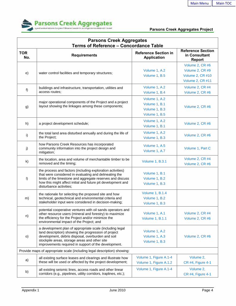
Parsons Creek Aggregates Project
Appendix 1 June 2010 Page 4
Parsons Creek AggregatesTerms of Reference – Concordance Table
TORNo. Requirements Reference Section in
Application
Reference Sectionin Consultant
Report
e) water control facilities and temporary structures;Volume 1, A.2Volume 1, B.5
Volume 2, CR #6Volume 2, CR #9
Volume 2, CR #10Volume 2, CR #11
f) buildings and infrastructure, transportation, utilities andaccess routes;
Volume 1, A.2Volume 1, B.4
Volume 2, CR #4Volume 2, CR #6
g)major operational components of the Project and a projectlayout showing the linkages among these components;
Volume 1, A.2Volume 1, B.1Volume 1, B.3Volume 1, B.5
Volume 2, CR #6
h) a project development schedule;Volume 1, A.2Volume 1, B.1
Volume 2, CR #6
i) the total land area disturbed annually and during the life ofthe Project;
Volume 1, A.2Volume 1, B.3
Volume 2, CR #6
j)how Parsons Creek Resources has incorporatedcommunity information into the project design andmitigation;
Volume 1, A.5Volume 1, A.7
Volume 1, Part C
k) the location, area and volume of merchantable timber to beremoved and the timing; Volume 1, B.3.1
Volume 2, CR #4Volume 2, CR #6
l)
the process and factors (including exploration activities)that were considered in evaluating and delineating thelimits of the limestone and aggregate reserves and discusshow this might affect initial and future pit development anddisturbance activities;
Volume 1, B.1Volume 1, B.2Volume 1, B.3
m)the rationale for selecting the proposed site and howtechnical, geotechnical and environmental criteria andstakeholder input were considered in decision-making;
Volume 1, B.1.4Volume 1, B.2Volume 1, B.3
n)
potential cooperative ventures with oil sands operators andother resource users (mineral and forestry) to maximizethe efficiency for the Project and/or minimize theenvironmental impact of the Project; and
Volume 1, A.1Volume 1, B.1.1
Volume 2, CR #4Volume 2, CR #6
o)
a development plan of appropriate scale (including legalland description) showing the progression of projectdevelopment, debris disposal, overburden and soilstockpile areas, storage areas and other siteimprovements required in support of the development.
Volume 1, A.2Volume 1, A.3Volume 1, B.3
Volume 2, CR #6
Provide maps of appropriate scale (including legal description) showing:
a) all existing surface leases and clearings and illustrate howthese will be used or affected by the project development;
Volume 1, Figure A.1-4Volume 1, Figure A.1.2
Volume 2,CR #4, Figure 4-1
b) all existing seismic lines, access roads and other linearcorridors (e.g., pipelines, utility corridors, traplines, etc.);
Volume 1, Figure A.1-4 Volume 2,CR #4, Figure 4-1

Parsons Creek Aggregates Project
Appendix 1 June 2010 Page 5
Parsons Creek AggregatesTerms of Reference – Concordance Table
TORNo. Requirements Reference Section in
Application
Reference Sectionin Consultant
Report
c)
the location of the development relative to all terrestrialcomponents (e.g., soils, topography, watercourses,vegetation, wildlife habitat, watersheds, wetlands, etc.).
Volumes 2 & 3,CR # 4, 5, 6, 7, 8, 9 &
11
4.3 Water Supply, Water Management and WastewaterManagement
The EPEA and Water Act require approvals for the use ofsurface and/or subsurface water including water forprocessing, discharge of processing water and surfacerunoff from the site into a surface waterbody. Identifydevelopment activities that may affect surface water orgroundwater including water treatment processes andchemicals added. Identify the purpose of any drilledwell(s).
Volume 1, B.5Volume 1, Part G
Volume 3, CR # 9, 10&11
Provide a water supply and water management plan to discuss the following:
a)site runoff and containment, erosion control, groundwaterprotection, muskeg dewatering, quarry pit dewatering anddisposal and/or treatment of wastewater;
Volume 1, B.5Volume 1, Part G
Volume 2, CR # 6Volume 3, CR# 9, 10 &
11
b)
how water management facilities, will adequately protectquarry operations from precipitation events (includingsignificant open water flood and ice jam occurrences) andaddress the application of The Canadian Dam Association,Dam Safety Guidelines.;
Volume 1, B.5Volume 1, Part G
Volume 2, CR # 6Volume 3, CR# 9
c) permanent or temporary alterations or realignments towaterbodies and wetlands; Volume 1, B.5.2
Volume 2, CR # 6Volume 3, CR# 9 & 11
d) process, sanitary and potable water requirements duringnormal operations and emergencies;
Volume 1, B.5.3Volume 3, CR# 9 & 11
e) water sources to be used including volumes expected fromeach source and location of diversion;
Volume 1, B.5.2.2 Volume 3, CR# 9, 10 &11
f)the application of Alberta Environment’s GroundwaterEvaluation Guideline for non-saline groundwater sourcesand dewatering activities; and
Volume 1, B.5.2Volume 1, Part G Volume 3, CR# 10
g)
any water minimization considerations including plans toensure efficient water use including any variability in waterquantity required on an annual basis and duringconstruction.
Volume 1, B.5.2Volume 3, CR# 9 & 10
4.4 Air Emissions Management
Identify and describe project emission sources, including point and area sources, slash burning sources, mobile sources andfugitive emissions. Estimate the range of emissions from all sources identified above for normal and worst-case conditions.Discuss the following from a management perspective:
a)potential odorous or visual emissions;
Volume 1, B.7 Volume 2, CR# 1

Parsons Creek Aggregates Project
Appendix 1 June 2010 Page 6
Parsons Creek AggregatesTerms of Reference – Concordance Table
TORNo. Requirements Reference Section in
Application
Reference Sectionin Consultant
Report
b)probable deposition areas and effects to soils, vegetationand waterbodies; Volume 1, B.7 Volume 2, CR# 1
c)the emission control technologies proposed for the Projectin the context of best-available technologies; and
Volume 1, A.7Volume 1, B.7
Volume 2, CR# 1
d)monitoring programs that will be implemented to assess airquality and the effectiveness of mitigation measuresimplemented during project development and operation.
Volume 1, A.7Volume 1, B.7
Volume 2, CR# 1
4.5 Chemical Handling and Waste Management
Provide information on the character and volume of anymaterials used or solid or liquid waste material generatedor stored on-site at the Project including a plot plan for on-site disposal areas that might be established. Describestrategies to minimize the potential for accidental releaseor spills and mitigation plans.
Volume 1, B.10
Identify the location and amount of all on-site storage ofchemicals. Explain containment and environmentalprotection measures for handling chemicals, includingexplosives.
Volume 1, B.10
4.6 Infrastructure, Utilities and Transportation
Describe the project infrastructure requirements, existing and proposed, including, but not limited to, the following:
a) haul roads routing and design, limestone crushing andhandling facilities, stockpile sites, and transport facilities; Volume 1, B.4
b)
volumes, timing (where applicable) and types of trafficassociated with the movement of goods, services andpersonnel to and from the Project during the construction,operation and reclamation phases;
Volume 1, B.4
c)the impact of increased vehicle traffic on the existingroadway system considering other existing and planneddevelopments in the region;
Volume 1, B.4
d)
road access to and within the Project Area, the need toupgrade existing or construct new roads and the impacts ofany new road construction or road improvements ifrequired;
Volume 1, B.4
e)
how Parsons Creek Resources plans to address theprovincial transportation department’s concerns withregards to access to borrow materials, truck staging areasand the provision of adequate buffers to protect the futureHighway 63 right-of-way;
Volume 1, B.4
f)
the result of consultation with the local transportationauthorities and other stakeholders, including transportationstudies that are underway or planned. Indicate how localcommunity needs have been considered in accessmanagement; and
Volume 1, A.4Volume 1, B.4
Volume 1, Part C

Parsons Creek Aggregates Project
Appendix 1 June 2010 Page 7
Parsons Creek AggregatesTerms of Reference – Concordance Table
TORNo. Requirements Reference Section in
Application
Reference Sectionin Consultant
Report
g) how public access to, or within the Project will be managedduring different development phases of the Project.
Volume 1, A.5Volume 1, B.4
Volume 1, Part C
4.7 Environmental Management System
Outline the elements of Parsons Creek Resources’environmental, health and safety management system anddiscuss how it will be integrated into the Project. Providecorporate policies and procedures, spill and air emissionreporting procedures and emergency response plans.Describe new monitoring intiatives that may be required asa result of the Project and outline Parsons CreekResources’ commitment to adaptive environmentalmanagement.
Volume 1, B.11Volume 1, B.12
4.8 Conservation and Reclamation
Provide a conceptual Conservation and Reclamation Plan (C&R Plan) for the Project, including:
a)
the objectives for reclamation, proposed end land useobjectives and other factors necessary for C&R Planimplementation including: Volume 1, Part B.3 Volume 2, CR# 6
i)alternative technologies considered; Volume 1, B.1
Volume 1, B.6
ii)shared facilities and utilities with the Project;
iii)catalysts and chemicals needed for the upgrading andrefining processes included in the Project; Volume 1, B.11
iv)project inputs such as energy and water, and the outputssuch as emissions and wastes; Volume 1, B.5
Volume 1, B.7
v)
effect of technology on waste generation and storagerequirements, air and water discharges, waterrequirements, waste streams, and effects to reclamationprograms; and
Volume 1, B.5Volume 1, B.7
Volume 1, B.10

Parsons Creek Aggregates Project
Appendix 1 June 2010 Page 8
Parsons Creek AggregatesTerms of Reference – Concordance Table
TORNo. Requirements Reference Section in
Application
Reference Sectionin Consultant
Report
vi)source of major feed materials for the upgrading processincluding bitumen feedstock and limestone, as well asother feedstocks.
Volume 1, B.1Volume 1, B.3Volume 1, B.5
vii)
Identify the location and amount of all on-site storageassociated with production including storage of catalysts,chemicals, products, by-products, intermediates andwastes (additional detail can be found in Section 3.7).Explain containment and environmental protectionmeasures.
Volume 1, B.11Volume 1, B.12
viii) the amount and source of energy required for the Project;Volume 1, B.5
Volume 1, B.10
ix)
the options considered for supplying the thermal energyand electric power required for the Project and theirenvironmental implications, including opportunities toincrease the energy efficiency of the Project with the use ofwaste heat or cogeneration of heat and electrical power;
Volume 1, B.5Volume 1, B.6
x)worker accommodations and travel routes to the plant siteduring construction and operation phases, including:
Volume 1, B.4Volume 1, B.5
b)how the land will be returned to pre-disturbed equivalentcapability having regard for regulatory requirements andend land use;
Volume 1, B.3 Volume 2, CR# 5, 6 & 7
c)references to examples of demonstrated success withrespect to proposed reclamation techniques, whereapplicable;
Volume 2, CR# 5, 6 & 7
d)operational or mitigative procedures that may be requiredto ensure that water quality and quantity in the AthabascaRiver is not impacted as a result of the Project;
Volume 1, B.5 Volume 2, CR# 9, 10 &11
e)
potential collaborative reclamation procedures consideredamong Parsons Creek Resources and any otherdevelopers should the Project Area be subject to morethan one land use, and review any discussions thatParsons Creek Resources has had with these otherdeveloper(s); and
Volume 1, B.3 Volume 2, CR# 4, 5, 6& 7
f)
detailed supporting information demonstrating how theintegrity of the reclaimed quarry can be protected duringsignificant open water flooding and ice jam occurrencesalong the Athabasca River.
Volume 2, CR# 6, 9, 10& 11
4.9 Participation in Regional Cooperative Efforts
Discuss Parsons Creek Resources’ current and plannedinvolvement in regional cooperative efforts that addressenvironmental and socio-economic issues associated withregional development, including the CumulativeEnvironmental Management Association (CEMA), theWood Buffalo Environmental Association (WBEA), theRegional Aquatics Monitoring Program (RAMP) and their
Volume 1, Part A.4 Volume 2, CR# 6
Parsons Creek Aggregates Project
Appendix 1 June 2010 Page 9
Parsons Creek AggregatesTerms of Reference – Concordance Table
TORNo. Requirements Reference Section in
Application
Reference Sectionin Consultant
Reportworking groups. Include Parsons Creek Resources’participation in regional air, water and other environmentalmonitoring programs, health studies, research, TEK andsocio-economic studies.
Describe how Parsons Creek Resources will contribute tothe effective design and implementation of proposedmitigation measures, monitoring programs and researchprograms within these regional cooperative efforts.
5.0 ENVIRONMENTAL ASSESSMENT AND CUMULATIVE EFFECTS ASSESSMENT
Define assessment scenarios, including:
a) a Baseline Scenario, which includes existing environmentalconditions, existing and approved projects or activities; Volume 1, D.2
b) an Application Scenario, which includes the BaselineScenario plus the Project; and Volume 1, D.2
c)a Cumulative Effects Assessment (CEA) Scenario, whichincludes the Application Scenario (Baseline Scenario plusProject) plus planned projects or activities.
Volume 1, D.2
Note: For the purposes of defining assessment scenarios,“approved” means approved by any federal, provincial ormunicipal regulatory authority, and “planned” means anyproject or activity that has been publicly disclosed prior tothe issuance of the Terms of Reference or up to sixmonths prior to the submission of the Project Applicationand the EIA report, whichever is most recent.
For the cumulative effects assessment, each of theenvironmental, social, economic, health, and land usecomponents will be evaluated, assessed and discussedwhere combined effects could reasonably be considered toresult due to development of the Project in combinationwith other existing, approved and planned projects in theregion. Include industrial projects as well as activitiesassociated with other land uses and infrastructure.
Volume 1, D.2
5.1 Basic Information Requirements for the Environmental Assessment
The EIA report will include the following basic environmental information:
a)
quantitative and qualitative information about theenvironment and ecological processes in the StudyArea(s), including relevant information presented inprevious environmental assessments;
Volumes 2 & 3
b)information about the human activities in the StudyArea(s); e.g., land disturbance, discharges of substances,changes to access status and effects that the Project mayhave on the present and future capacity of renewable
Volumes 2 & 3

Parsons Creek Aggregates Project
Appendix 1 June 2010 Page 10
Parsons Creek AggregatesTerms of Reference – Concordance Table
TORNo. Requirements Reference Section in
Application
Reference Sectionin Consultant
Reportresources;
c) a discussion of the process employed to classify andevaluate the effects associated with the Project; Volume 1, D.2.2
d)management plans to prevent, minimize or mitigateadverse effects and to monitor and respond to expected orunanticipated conditions; and
Volume 1, B.11
e) a discussion of residual effects. Volume 1, A.6
f)
Where models are used, document any assumptions usedin the EIA report to obtain predictions. Clearly identify thedata used in the modeling including sources of error andrelative accuracy, and identify the limitations of the modelsand steps taken to improve the accuracy. Describe theapplicability and reasons for using a particular model,
Volumes 2 & 3
5.2 Study Area(s)
Define and provide the rationale for the spatial andtemporal boundaries for the Study Area(s) used for theassessment. Discuss the selection criteria used todetermine the Study Area(s), including information sourcesand assessment methods. The spatial boundaries shallinclude all areas where measurable changes in theenvironment may be caused by the Project regardless ofany political boundaries.
Volume 1, D2.3
5.3 Land Use and Access to Public Lands
Describe baseline land use and access to public lands in the Study Area(s) and discuss the impacts on these for each scenario.Identify/discuss:
a)the existing land uses and discuss the potential impact(s)of the Project to these land uses. Describe strategies tomitigate the impact(s);
Volume 1, E.4 Volume 2, CR# 4, 4.0 &5.0
b)any land use policies and resource management initiativesthat pertain to the Project Area and discuss how theProject will be consistent with these policies;
Volume 1, E.4 Volume 2, CR# 4, 3.0
c)any unique sites or rare features within the Project Areathat may be impacted by the Project. Describe strategiesto mitigate these impact(s);
Volume 1, E.4
d)potential changes in land use, land management, otherindustrial uses in the region, and recreational uses thatmay result from the Project;
Volume 1, E.4 Volume 2, CR# 4, 3.5
e)how public access to the development area and adjacentCrown lands will be managed during the developmentphases and the need for access management;
Volume 1, E.4 Volume 2, CR# 4, 3.6
f) the impact of the proposed development and reclamationon commercial forest harvesting; Volume 1, E.4 Volume 2, CR# 4, 3.5
g) the potential for increased access into the area that maybe associated with project development and its impact on
Volume 1, E.4 Volume 2, CR# 4, 3.6
Parsons Creek Aggregates Project
Appendix 1 June 2010 Page 11
Parsons Creek AggregatesTerms of Reference – Concordance Table
TORNo. Requirements Reference Section in
Application
Reference Sectionin Consultant
Reportother resources and resource use such as increasedhunter, off-highway vehicle and other recreational users;
h)the results of consultation with other industry operators andAboriginal communities regarding access to the ProjectArea; and
Volume 1, C.3 Volume 3, CR# 13
i)
the impact project development may have on any mineableoil sands resources in the Project Area. Discuss howproject development has been coordinated with adjacentdevelopment(s). Discuss any limitations that the Projectmay have on other potential or approved developments.
Volume 1, E.4 Volume 2, CR# 4, 5.2
5.4 Air Quality
Discuss baseline ambient air quality conditions. Review current emission sources and discuss changes as a result ofanticipated future industrial development within the EIA Study Areas. Consider emission point sources as well as fugitiveemissions. Identify components of the Project that will affect ambient air quality from a local and regional perspective by doingthe following:
a)discuss appropriate air quality parameters such as oxidesof nitrogen (NOx), visibility, and particulates (road dust,PM10 and PM2.5);
Volume 2, CR# 1, 2
b)
estimate ground-level concentrations via modeling ofappropriate air quality parameters. Discuss any expectedchanges to particulate deposition patterns. Include acomparison of modeled concentrations to recentmonitoring results, as appropriate;
Volume 2, CR# 1, 4, &5
c)
identify the potential for reduced air quality (includingodours and visibility) resulting from the Project and discussany implications of the expected air quality forenvironmental protection and public health. Provide thisinformation specifically for communities and sensitivereceptors located close to the Project, as appropriate;
Volume 2, CR# 1, 6
d)describe air quality impacts resulting from the Project, andtheir implications for other environmental resources,including vegetation resources, and water and soil quality;
Volume 2, CR# 1, 6
e)
for acid deposition modeling, provide deposition datapredictions including magnitude and location of predictedmaximum levels for all areas within the 0.25 keq/ha/yr and0.17 keq/ha/yr Potential Acid Input (PAI) isopleth, includinganalysis of PAI deposition levels consistent with the CEMAAcid Deposition Management Framework;
Volume 2, CR# 1, 6.3
f)complete modeling and present results in accordance withAlberta Environment's Air Quality Modeling Guidelines(March 2003);
Volume 2, CR# 1
g)
describe how air quality impacts resulting from the Projectwill be mitigated and any monitoring programs to beimplemented for assessing air quality or the effectivenessof mitigation measures;
Volume 2, CR# 1, 6.4 &6.7
h) discuss the use of ozone depleting substances; Volume 1, B.7
Parsons Creek Aggregates Project
Appendix 1 June 2010 Page 12
Parsons Creek AggregatesTerms of Reference – Concordance Table
TORNo. Requirements Reference Section in
Application
Reference Sectionin Consultant
Report
i)describe meteorological conditions including wind speed,direction and inversions insofar as they affect dispersionand disposition; and
Volume 1, B.7
j) estimate the quantity released of any compoundsregulated under the NPRI. Volume 1, B.7
5.4.1 Greenhouse Gas Emissions
Provide the following:
a)the expected annual and total greenhouse gas (GHG)emissions over the construction, operation anddecommissioning phases of the Project;
Volume 1, B.8
b) the Project’s contribution to total provincial and nationalGHG emissions on an annual basis; Volume 1, B.8
c)the intensity of GHG emissions per unit of productproduced and how it compares with similar projects andtechnology performance;
Volume 1, B.8
d)
how the project design and GHG management plans takeinto account the need for continuous improvement withrespect to GHG emissions and the plan Albertans andClimate Changes; Taking Action; and
Volume 1, B.8
e)
Graymont Western Canada Inc and Inland AggregatesLimited overall GHG management plans, any plans for theuse of offsets (nationally or internationally) and theexpected results of implementing the plans.
Volume 1, B.8
5.4.2 Climate Change
Discuss the following:
a) climate change and the local and/or regional, inter-provincial/territorial changes to environmental conditionsresulting from climate conditions, including trends andprojections where available (in accordance with theguidance document Incorporating Climate ChangeConsiderations in Environmental Assessment: GeneralGuidance for Practitioners);
Volume 1, B.8.3
b)
stages or elements of the Project that are sensitive tochanges or variability in climate parameters. Discuss whatimpacts the change to climate parameters may have onelements of the Project that are sensitive to climateparameters; and
Volume 1, B.8.3
c)the adaptability of the Project in the event the region’sclimate changes. Discuss any follow-up programs andadaptive management considerations.
Volume 1, B.8.3
5.5 Noise
Provide baseline noise levels. Discuss;
Parsons Creek Aggregates Project
Appendix 1 June 2010 Page 13
Parsons Creek AggregatesTerms of Reference – Concordance Table
TORNo. Requirements Reference Section in
Application
Reference Sectionin Consultant
Report
a)the results of a noise assessment as specified by EUBDirective 038 Noise Control (or the most recent version ofthe document) including: and
Volume 1, E.3 Volume 2, CR# 3, 5.0
i) an estimate of the potential for increased noise resultingfrom the Project; Volume 1, E.3 Volume 2, CR# 3, 5.0
ii) identification of potentially affected people and wildlife;and Volume 1, E.3 Volume 2, CR# 3, 5.0
iii) the implications of any increased noise levels.Volume 1, E.3.6Volume 1, A.6.3
Volume 2, CR# 3, 6.0
b) mitigation options, considering such factors as intensity,magnitude, frequency, duration and time of day. Volume 1, A.7.3 Volume 2, CR# 3, 5.7
5.6 Terrestrial and Aquatic Ecosystems
5.6.1 Geology, Soils, Terrain
Describe the following:
a)
the baseline conditions of bedrock, bedrock topograpy andsurficial geology, soils and terrain in the Study Area(s).Where appropriate, use maps, cross-sections and figuresto illustrate these features;
Volume 1, B.2Volume 1, E.4.2
b)
the soil types and their distribution in the ProjectDevelopment Area and Study Areas. Provide anecological context to the soil resource by supplying a soilsurvey report and maps; and
Volume 2, CR# 5, 3.0 &4.0
c) changes to these baseline conditions that may occur dueto development of the Project.
Volume 1, E.4.3 Volume 2, CR#5, 6.0
5.6.2 Vegetation
Describe and map vegetation communities in the EIA Study Area(s), using as appropriate, the Alberta Vegetation Inventory(AVI) Standards Manual 2.1, The Field Guide to Ecosites of Northern Alberta (Beckingham and Archibald, 1996), and theAlberta Wetland Inventory Standards Manual (AWI) Version 1.0. For each assessment scenario, discuss the following:
a)ecosite phases based on their potential to support rareplant species, old growth forests or other communities ofrestricted distribution (e.g., fens).
Volume 2, CR# 7, A.4
b) the species associated with each ecosite phase andaddress: Volume 2, CR# 7, A.4
i) special status plant species (rare, threatened orendangered); Volume 2, CR# 7, A.4
ii)the importance of the size, distribution and variety ofvegetation units assessed in habitat suitability indices forwildlife and riparian habitat;
Volume 2, CR# 7, A.2
iii)the importance of peatland and wetland species andlandscape units for local and regional habitat, sustainedforest growth and the hydrologic regime. Determine therarity or abundance of peatlands and wetlands from local
Volume 2, CR# 7, A.2

Parsons Creek Aggregates Project
Appendix 1 June 2010 Page 14
Parsons Creek AggregatesTerms of Reference – Concordance Table
TORNo. Requirements Reference Section in
Application
Reference Sectionin Consultant
Reportand regional perspectives; and
iv) the availability of plants used for food, medicinal andcultural purposes; Volume 2, CR# 7, A.4
c)
the sensitivity to disturbance of each of the vegetationcommunities and their ability to be restored, as well as thetechniques used to estimate sensitivity to disturbance andreclamation (e.g., sensitivity to air emissions);
Volume 1, E.7.3 & E.7.4Volume 1, A.6.7
Volume 2, CR# 7, PartB, 8.0 & 9.0
d)the nature, size, distribution and timing of changes tovegetation communities, including the effects of airemissions;
Volume 1, E.7.3 & E.7.4Volume 1, A.6.7
Volume 2, CR# 7, PartB, 8.0 & 9.0
e)
the area of productive and non-productive forest land basethat will be disturbed and taken out of production duringthe life of the Project. Describe plans for the return of pre-disturbance forest ecosites by area, species andproductivity;
Volume 1, E.7.3 & E.7.4Volume 1, A.6.7
Volume 2, CR# 7, PartB, 8.0 & 9.0
f) introduction of non-native plant species on native speciescomposition and potential plant changes to communities;
Volume 1, E.7.3 & E.7.4Volume 1, A.6.7
Volume 2, CR# 7, PartB, 8.0 & 9.0
g)the extent to which existing seismic lines, and linearcorridors and other existing disturbances will be used forproject facilities;
Volume 1, B.3 & B.4
h)the area and distribution of all vegetation communitiesexisting prior to the project development and expected atclosure; and
Volume 1, E.7.3, E.7.4 &E.6.4
Volume 2, CR# 7, A.4Volume 2, CR#6, 4.0
i)plans to mitigate the adverse effects of site clearing andother development activities and operations on vegetation,including rare plant species.
Volume 1, E.7.2Volume 1, A.6.8
Volume 2, CR# 7, PartB, 7.0
5.6.3 Wildlife
Describe existing wildlife resources and their use of habitats in the Study Area(s). Document the anticipated changes to wildlifein the Study Area(s) under each scenario. Specifically:
a)
discuss the criteria and process used in the selection ofwildlife indicator species, including those listed by AlbertaFish and Wildlife (at risk, may be at risk and sensitivespecies in the General Status of Alberta Wild Species2000) and COSEWIC (endangered, threatened, specialconcern in Canadian Species at Risk 2002);
Volume 1, E.8.1 Volume 3, CR# 8; A.1,B1.1 & B.1.2
b)
identify species composition, distribution, relativeabundance, seasonal movements, movement corridors,habitat requirements, key habitat areas, and general lifehistory in the Study Area(s);
Volume 1, E.8.1 Volume 3, CR# 8; A.4,A.5, A.6
c)include current field data, using recognized samplingprotocols, for the species chosen for evaluation in the EIAreport;
Volume 3, CR# 8; A.2,A.4, A.5, A.6
d) evaluate potential adverse impacts on, habitat availability,quality, and effective wildlife use of habitat due to the
Volume 1, E.8.2Volume 1, A.6.8
Volume 3, B.1.4

Parsons Creek Aggregates Project
Appendix 1 June 2010 Page 15
Parsons Creek AggregatesTerms of Reference – Concordance Table
TORNo. Requirements Reference Section in
Application
Reference Sectionin Consultant
ReportProject
e)
describe the spatial and temporal changes to habitat andto wildlife distribution, relative abundance, movements, andthe potential to return the area to pre-disturbed wildlifehabitat conditions, including:
Volume 1, E.8.2Volume 1, A.6.8
Volume 3, B.1.4
i) anticipated effects on wildlife as a result of changes to airand water, including both acute and chronic effects onanimal health;
Volume 1, E.8.2Volume 1, A.6.8
Volume 3, B.1.4
ii) anticipated effects on wildlife as a result of project activity;and
Volume 1, E.8.2Volume 1, A.6.8
Volume 3, B.1.4
iii) anticipated effects on wildlife due to improved or alteredaccess into the area (e.g., vehicle collisions with wildlife,obstructions to daily or seasonal movements, and huntingmortality during operations and after project closure);
Volume 1, E.8.2Volume 1, A.6.8
Volume 3, B.1.4
f)discuss the protection of riparian habitats, interconnectivityof such habitat, and the movement by wildlife speciesusing the habitat;
Volume 1, E.8.3Volume 1, A.7.8
Volume 3, B.1.3
g)indicate what measures will be taken to prevent habituationof wildlife, the potential for human-wildlife encounters andconsequent destruction of wildlife (e.g., black bears);
Volume 1, E.8.3Volume 1, A.7.8
Volume 3, B.1.3
h)
describe the effects of the Project on those wildlife speciesselected for evaluation. Identify residual impacts anddiscuss their significance at the local and regional scales;and
Volume 1, E.8.2Volume 1, A.6.8
Volume 3, B.1.4
i)
provide a strategy and mitigation plan to minimize impactson habitat and wildlife populations through the life of theProject and to return productive wildlife habitat to the area,considering:
Volume 1, E.8.3Volume 1, A.7.8
Volume 3, B.1.3
i) habitat enhancement measures in adjacent undisturbedareas, and a schedule for the return of habitat capability toareas impacted by the Project;
Volume 1, E.8.3Volume 1, A.7.8
Volume 3, B.1.5
ii) consistency of the plan with applicable regional, provincialand federal wildlife habitat objectives and policies; and
Volume 1, E.8.3Volume 1, A.7.8
Volume 3, B.1.6
iii) monitoring programs to assess wildlife impacts from theProject and the effectiveness of mitigation strategies andhabitat enhancement measures.
Volume 1, E.8.3Volume 1, A.7.8
Volume 3, B.1.7
5.6.4 Biodiversity
Describe ecosystem characteristics in the Study Area(s), and explain the significance of potential project impacts from theperspective of biodiversity, including consideration of potential local and regional project impacts on:
a) ecosystem fragmentation;Volume 1, E.8
Volume 1, A.7.8Volume 3, CR# 8, A.7
b) habitat diversity and quantity; and Volume 1, E.8 Volume 3, CR# 8, A.7
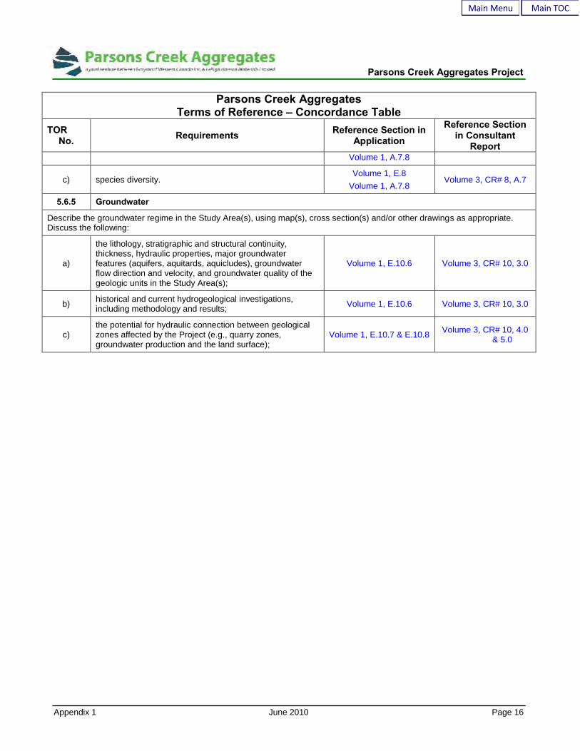
Parsons Creek Aggregates Project
Appendix 1 June 2010 Page 16
Parsons Creek AggregatesTerms of Reference – Concordance Table
TORNo. Requirements Reference Section in
Application
Reference Sectionin Consultant
ReportVolume 1, A.7.8
c) species diversity.Volume 1, E.8
Volume 1, A.7.8Volume 3, CR# 8, A.7
5.6.5 Groundwater
Describe the groundwater regime in the Study Area(s), using map(s), cross section(s) and/or other drawings as appropriate.Discuss the following:
a)
the lithology, stratigraphic and structural continuity,thickness, hydraulic properties, major groundwaterfeatures (aquifers, aquitards, aquicludes), groundwaterflow direction and velocity, and groundwater quality of thegeologic units in the Study Area(s);
Volume 1, E.10.6 Volume 3, CR# 10, 3.0
b) historical and current hydrogeological investigations,including methodology and results; Volume 1, E.10.6 Volume 3, CR# 10, 3.0
c)the potential for hydraulic connection between geologicalzones affected by the Project (e.g., quarry zones,groundwater production and the land surface);
Volume 1, E.10.7 & E.10.8 Volume 3, CR# 10, 4.0& 5.0
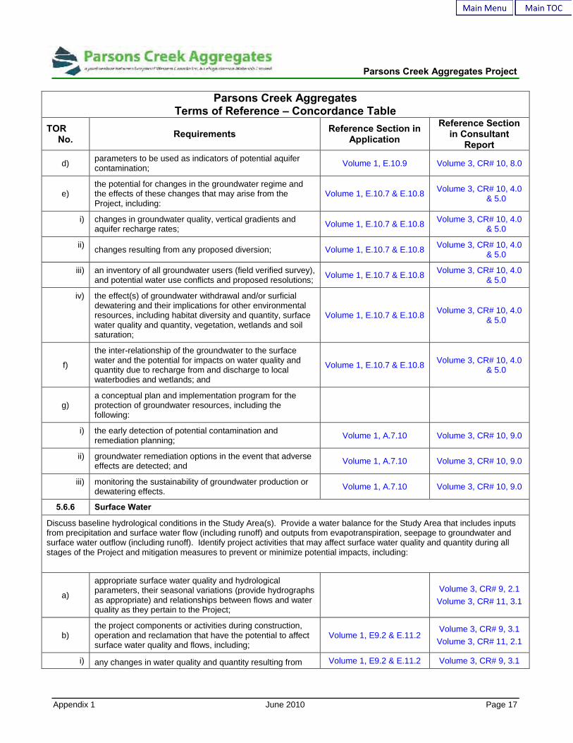
Parsons Creek Aggregates Project
Appendix 1 June 2010 Page 17
Parsons Creek AggregatesTerms of Reference – Concordance Table
TORNo. Requirements Reference Section in
Application
Reference Sectionin Consultant
Report
d) parameters to be used as indicators of potential aquifercontamination; Volume 1, E.10.9 Volume 3, CR# 10, 8.0
e)the potential for changes in the groundwater regime andthe effects of these changes that may arise from theProject, including:
Volume 1, E.10.7 & E.10.8 Volume 3, CR# 10, 4.0& 5.0
i) changes in groundwater quality, vertical gradients andaquifer recharge rates; Volume 1, E.10.7 & E.10.8 Volume 3, CR# 10, 4.0
& 5.0
ii) changes resulting from any proposed diversion; Volume 1, E.10.7 & E.10.8 Volume 3, CR# 10, 4.0& 5.0
iii) an inventory of all groundwater users (field verified survey),and potential water use conflicts and proposed resolutions; Volume 1, E.10.7 & E.10.8 Volume 3, CR# 10, 4.0
& 5.0
iv) the effect(s) of groundwater withdrawal and/or surficialdewatering and their implications for other environmentalresources, including habitat diversity and quantity, surfacewater quality and quantity, vegetation, wetlands and soilsaturation;
Volume 1, E.10.7 & E.10.8 Volume 3, CR# 10, 4.0& 5.0
f)
the inter-relationship of the groundwater to the surfacewater and the potential for impacts on water quality andquantity due to recharge from and discharge to localwaterbodies and wetlands; and
Volume 1, E.10.7 & E.10.8 Volume 3, CR# 10, 4.0& 5.0
g)a conceptual plan and implementation program for theprotection of groundwater resources, including thefollowing:
i) the early detection of potential contamination andremediation planning; Volume 1, A.7.10 Volume 3, CR# 10, 9.0
ii) groundwater remediation options in the event that adverseeffects are detected; and Volume 1, A.7.10 Volume 3, CR# 10, 9.0
iii) monitoring the sustainability of groundwater production ordewatering effects. Volume 1, A.7.10 Volume 3, CR# 10, 9.0
5.6.6 Surface Water
Discuss baseline hydrological conditions in the Study Area(s). Provide a water balance for the Study Area that includes inputsfrom precipitation and surface water flow (including runoff) and outputs from evapotranspiration, seepage to groundwater andsurface water outflow (including runoff). Identify project activities that may affect surface water quality and quantity during allstages of the Project and mitigation measures to prevent or minimize potential impacts, including:
a)
appropriate surface water quality and hydrologicalparameters, their seasonal variations (provide hydrographsas appropriate) and relationships between flows and waterquality as they pertain to the Project;
Volume 3, CR# 9, 2.1Volume 3, CR# 11, 3.1
b)the project components or activities during construction,operation and reclamation that have the potential to affectsurface water quality and flows, including;
Volume 1, E9.2 & E.11.2Volume 3, CR# 9, 3.1
Volume 3, CR# 11, 2.1
i) any changes in water quality and quantity resulting from Volume 1, E9.2 & E.11.2 Volume 3, CR# 9, 3.1
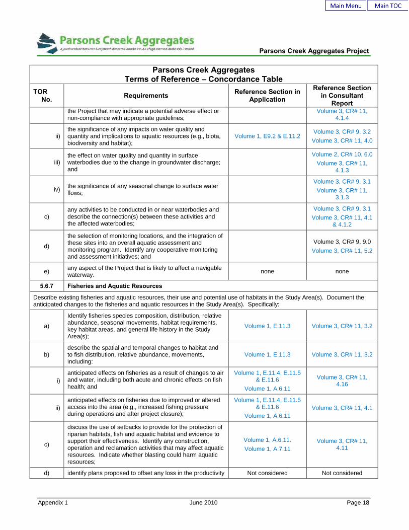
Parsons Creek Aggregates Project
Appendix 1 June 2010 Page 18
Parsons Creek AggregatesTerms of Reference – Concordance Table
TORNo. Requirements Reference Section in
Application
Reference Sectionin Consultant
Reportthe Project that may indicate a potential adverse effect ornon-compliance with appropriate guidelines;
Volume 3, CR# 11,4.1.4
ii)the significance of any impacts on water quality andquantity and implications to aquatic resources (e.g., biota,biodiversity and habitat);
Volume 1, E9.2 & E.11.2Volume 3, CR# 9, 3.2
Volume 3, CR# 11, 4.0
iii)the effect on water quality and quantity in surfacewaterbodies due to the change in groundwater discharge;and
Volume 2, CR# 10, 6.0Volume 3, CR# 11,
4.1.3
iv) the significance of any seasonal change to surface waterflows;
Volume 3, CR# 9, 3.1Volume 3, CR# 11,
3.1.3
c)any activities to be conducted in or near waterbodies anddescribe the connection(s) between these activities andthe affected waterbodies;
Volume 3, CR# 9, 3.1Volume 3, CR# 11, 4.1
& 4.1.2
d)
the selection of monitoring locations, and the integration ofthese sites into an overall aquatic assessment andmonitoring program. Identify any cooperative monitoringand assessment initiatives; and
Volume 3, CR# 9, 9.0Volume 3, CR# 11, 5.2
e) any aspect of the Project that is likely to affect a navigablewaterway. none none
5.6.7 Fisheries and Aquatic Resources
Describe existing fisheries and aquatic resources, their use and potential use of habitats in the Study Area(s). Document theanticipated changes to the fisheries and aquatic resources in the Study Area(s). Specifically:
a)
Identify fisheries species composition, distribution, relativeabundance, seasonal movements, habitat requirements,key habitat areas, and general life history in the StudyArea(s);
Volume 1, E.11.3 Volume 3, CR# 11, 3.2
b)describe the spatial and temporal changes to habitat andto fish distribution, relative abundance, movements,including:
Volume 1, E.11.3 Volume 3, CR# 11, 3.2
i)anticipated effects on fisheries as a result of changes to airand water, including both acute and chronic effects on fishhealth; and
Volume 1, E.11.4, E.11.5& E.11.6
Volume 1, A.6.11
Volume 3, CR# 11,4.16
ii)anticipated effects on fisheries due to improved or alteredaccess into the area (e.g., increased fishing pressureduring operations and after project closure);
Volume 1, E.11.4, E.11.5& E.11.6
Volume 1, A.6.11Volume 3, CR# 11, 4.1
c)
discuss the use of setbacks to provide for the protection ofriparian habitats, fish and aquatic habitat and evidence tosupport their effectiveness. Identify any construction,operation and reclamation activities that may affect aquaticresources. Indicate whether blasting could harm aquaticresources;
Volume 1, A.6.11.Volume 1, A.7.11
Volume 3, CR# 11,4.11
d) identify plans proposed to offset any loss in the productivity Not considered Not considered

Parsons Creek Aggregates Project
Appendix 1 June 2010 Page 19
Parsons Creek AggregatesTerms of Reference – Concordance Table
TORNo. Requirements Reference Section in
Application
Reference Sectionin Consultant
Reportof fish habitats. Indicate how environmental protectionplans address applicable provincial and federal policies onfish habitat including the development of a “No Net Loss”fish habitat objective; and
e)
describe mitigation to prevent adverse impacts; andmonitoring programs, as applicable, to assess fisheriesand aquatic resource impacts from the Project and theeffectiveness of mitigation strategies.
Volume 1, A.7.11Volume 1, E.11
Volume 3, CR# 11, 4.0Volume 3, CR# 11, 5.2
Volume 2, CR# 6
6.0 ENVIRONMENTAL MONITORING
Describe any additional environmental monitoring, notalready described elsewhere, that Parsons CreekResources will undertake to manage predicted effects andimprove environmental protection strategies. Describe anyproposed mitigation plans not already described, andidentify any anticipated residual effects.
Volume 1, A.7
7.0 PUBLIC HEALTH AND SAFETY
Describe those aspects of the Project that may have implications for public health or the delivery of health services. Determinewhether there may be implications for public health arising from the Project. Specifically:
a)identify and discuss the data and methods Parsons CreekResources used to assess impacts of the Project onhuman health and safety;
Volume 2, CR# 2, 2.0 &3.0
b)
assess the potential health implications of the compoundsthat will be released to the environment from the proposedoperation in relation to exposure limits established toprevent acute and chronic adverse effects on humanhealth;
Volume 1, E.2 Volume 2, CR# 2, 4.1 &4.2
c)identify the human health impact of the potentialcontamination of country foods and natural food sourcestaking into consideration all project activities;
Volume 1, E.2 Volume 2, CR# 2, 4.3
d) provide information on samples of selected species ofvegetation known to be consumed by humans; Volume 1, E.2 Volume 2, CR# 2, 4.3
e)discuss the potential to increase human exposure tocontaminants from changes to water quality, air quality andsoil quality taking into consideration all project activities;
Volume 1, E.2 Volume 2, CR# 2, 5.0
f)
document any health concerns identified by Aboriginalstakeholders due to the impacts of the Project specificallyon their traditional lifestyle. Determine the potential impactof the Project on the overall health of Aboriginalstakeholders and identify possible mitigation strategies;
Volume 1, E.2 Volume 2, CR# 2, 5.0
g)assess cumulative health effects to receptors that are likelyto result from the Project in combination with other existing,approved and planned projects;
Volume 1, E.2 Volume 2, CR# 2, 5.0
h)identify, as appropriate, the anticipated follow-up work,including regional cooperative studies. Identify how suchwork will be implemented and coordinated with ongoing air,
Volume 1, E.2Volume 1, A.7.2
Volume 2, CR# 2, 5.0

Parsons Creek Aggregates Project
Appendix 1 June 2010 Page 20
Parsons Creek AggregatesTerms of Reference – Concordance Table
TORNo. Requirements Reference Section in
Application
Reference Sectionin Consultant
Reportsoil and water quality initiatives;
i)identify and discuss the potential health and safety impactsdue to higher regional traffic volumes and the increasedrisk of accidental leaks and spills;
Volume 1, E.2Volume 1, A.7.2
Volume 2, CR# 2, 5.0
j) document the health and safety concerns raised bystakeholders during consultation on the Project; Volume 1, C.4 Volume 2, CR# 2, 5.2
k)
provide a summary of Parsons Creek Resources’emergency response plan and discuss mitigation plans toensure workforce and public safety during pre-construction, construction, operation and reclamation ofthe Project. Include prevention and safety measures forwildfire occurrences, accidental release or spill ofchemicals to the environment and failures of structuresretaining water or fluid wastes;
Volume 1, B.11
l)describe how local residents will be contacted during anemergency and the type of information that will becommunicated to them; and
Volume 1, B.11
m)
describe the existing agreements with area municipalitiesor industry groups such as safety co-operatives,emergency response associations and municipalemergency response agencies.
Volume 1, B.11
8.0 HISTORICAL RESOURCES
Describe those aspects of the Project that may have implications for historical resources and provide the following:
a)a general overview of the results of any previous historicresources studies that have been conducted in the StudyArea(s) as defined within the Historical Resources Act;
Volume 1, A.6.12Volume 1, A.7.12Volume 1, E.12
Volume 3, CR# 12
b) details of the consultation with the Heritage ResourcesManagement Branch with respect to historical resources; Volume 3, CR# 12
c) a summary of the results of the Historical ResourcesImpact Assessment;
Volume 1, A.6.12Volume 1, A.7.12Volume 1, E.12
Volume 3, CR# 12
d) details of the participation of Aboriginal peoples in theHistorical Resources Impact Assessment; Volume 1, C.3 Volume 3, CR# 12
e)details of any stakeholder concerns with respect to thedevelopment of the Project based on the historicalsignificance of the Local Study Area; and
Volume 1, C.3 Volume 3, CR# 12
f)
an outline of the historical resources management programand schedule of field investigations that may be requiredto assess and mitigate the effect of the Project on historicalresources pursuant to the Historical Resources Act;
Volume 1, A.6.12Volume 1, A.7.12Volume 1, E.12
Volume 3, CR# 12
9.0 TRADITIONAL LAND USE
Describe the following:

Parsons Creek Aggregates Project
Appendix 1 June 2010 Page 21
Parsons Creek AggregatesTerms of Reference – Concordance Table
TORNo. Requirements Reference Section in
Application
Reference Sectionin Consultant
Report
a)
historical and current traditional use of the Study Area(s)by First Nations and Métis, including fishing, hunting,trapping, plant harvesting and any other traditional orcultural uses as identified by Aboriginal groups;
Volume 3, CR # 13
b)Parsons Creek Resources’ consultation with Aboriginalstakeholders to determine their concerns regarding projectdevelopment on traditional use of the Study Area(s); and
Volume 1, C.3
c)the effects of the Project on First Nations and Métistraditional land use and culture, and identify possiblemitigation strategies.
Volume 1, C.4Volume 1 A.6.13
d)how Traditional Environmental Knowledge (TEK) will beincorporated into the Environmental Impact Assessment;and
Volume 1, C.4Volume 1, A.7.13
e) how TEK will be utilized during operations i.e. using TEK inreclamation plans. Volume 1, C.4
Provide map(s) of appropriate scale(s) showing the traditional land use areas of Aboriginal peoples.
10.0 SOCIO-ECONOMIC FACTORS
Discuss the following:
a)
socio-economic conditions before and after projectdevelopment, including the number of people who may beaffected, population changes, local employment, localprocurement, traffic and existing local and regionalservices including existing social agencies, educationinitiatives, training programs and business developmentinitiatives;
Volume 1, A.6.14Volume 1, E.14
Volume 3, CR # 14, 1.1
b)
the impacts of the proposed Project on the availability ofaffordable housing and the quality of health care services.Identify and discuss the mitigation plans that will beundertaken to address these issues. Provide a summaryof any discussions that have taken place with theMunicipality and Regional Health Authority concerninghousing availability and health care services respectively;
Volume 1, A.6.14Volume 1, E.14
Volume 3, CR # 14, 1.3
c)
capital investment, labour requirements, and otheroperating costs and revenue from services relating to theProject. Include an estimated breakdown of the Alberta,other Canadian and foreign industrial benefits relating toproject management and engineering, equipment andmaterials, construction labour. Estimate the total overallproject costs and revenues;
Volume 1, A.6.14Volume 1, E.14
Volume 3, CR # 14, 1.2
d)the employment and business development opportunitiesthe Project may create and the economic impact in theStudy Area(s), region, province and Canada;
Volume 1, A.6.14Volume 1, E.14
Volume 3, CR # 14, 1.2
e)Parsons Creek Resources’ Aboriginal procurementpolicies, and Aboriginal training and hiring policies andpractices for the project;
Volume 1, C.5.4

Parsons Creek Aggregates Project
Appendix 1 June 2010 Page 22
Parsons Creek AggregatesTerms of Reference – Concordance Table
TORNo. Requirements Reference Section in
Application
Reference Sectionin Consultant
Report
f)
Parsons Creek Resources’ policy for managing site access(e.g. hunting, fishing etc.) by contractors duringconstruction and employees and contractors duringoperations;
Volume 1, E.4 Volume 2, CR # 4, 3.6
g)Parsons Creek Resources’ policies and programsrespecting the use of local, regional, Alberta and Canadiangoods and services;
Volume 1, C.5.4 Volume 3, CR # 14, 1.2
h)potential project demands upon local services andinfrastructure; and
Volume 1, A.6.14Volume 1, E.14
Volume 3, CR # 14, 1.2
i)quantify local, regional and provincial economic benefitsarising from the Project.
Volume 1, A.6.14Volume 1, E.14
Volume 3, CR # 14, 1.2
11.0 PUBLIC CONSULTATION REQUIREMENTS
Describe the following:
a)
the public consultation process implemented for the Projectincluding the involvement of local residents, and other keystakeholders such as oil sands operators, special interestgroups, First Nations and Métis within the Study Area(s);
Volume 1, C.1 Volume 2, CR #4Volume 3, CR# 13
b)the methods by which information was provided to thepublic, the type of information provided, and the nature ofresponses received including:
Volume 1, C.2 & C.3
i) where and when public meetings were held and, to theextent possible, list attendees;
Volume 1, C.2
ii)how concerns and ideas were brought to the attention ofParsons Creek Resources and the actions taken toaddress the concerns;
Volume 1, C.4
iii)how issues and resolution of concerns were incorporatedinto the project development, impact mitigation andmonitoring;
Volume 1, C.4
c)
plans to maintain the public consultation process followingcompletion of the Environmental Assessment review toensure that the public will have an appropriate forum forproviding their input and expressing their views on theongoing development, operation and reclamation of theProject.
Volume 1, C.5