Arbor biokaps (hs palm tree pipe) case study in lanciano city 65 days update(eng)

DOWNTOWN HISTORIC
PALM HARBOR
MASTER PLAN
FIN
AL
RE
PO
RT
FIN
AL
RE
PO
RT
Adopted by thePinellas County Board of County Commissioners
on December 18, 2001Ordinance # 01-85
Amended on April 24, 2012Ordinance # 12-16
andFebruary 10, 2015Ordinance # 15-07

Table of Contents
DO
WN
TOW
N H
ISTO
RIC
PA
LM H
AR
BO
R M
AS
TER
PLA
N
Title Page Number
Executive Summary...................................................................1
Background................................................................................3
Existing Conditions....................................................................4
Participation Process................................................................10
Concept Plan ............................................................................12
Revitalization Code..................................................................22
Implementation ........................................................................26
Appendix A ..............................................................................28
Appendix B ..............................................................................31
EXECUTIVE SUMMARY
1
Downtown Historic Palm Harbor has established a clear vision for its future, that builds on its character, heritage and sense of place. By tying together the past, present and future it creates a vibrant town center.
In truth, Downtown Historic Palm Harbor has what many communities are trying to rediscover - or create something they never had - a walkable community described by a tight urban grid, buildings close to the street, homes with porches and convenient shopping and services.
The purpose of this project was to take the Vision Statement for Downtown Historic Palm Harbor to the next level of design development. The four major components of the Vision Statement are:
IMAGE
tCommunity Character - small town atmosphere
INHERITANCE
tCommunity Heritage - historic design
INTERACTION
tSense of Community - gathering places
INVESTMENT
tLocal Businesses - mix, growth and utilization
The size and image of Palm Harbor reflect an approachable, friendly atmosphere. Palm Harbor is fortunate to have an interesting history and caring citizens who worked to preserve the community’s buildings and character. Many communities have no such inheritance to build upon. The Master Plan process included much interaction through consensus building sessions. There was excellent citizen turnout and feedback. This sense of community and interaction is reflected in the desire to include gathering places in the Master Plan.
The products and process of this project translated the four vision components into physical plans for streetscape, roadway and drainage improvements, zoning regulation and aesthetic design. The products of these efforts are listed as follows:
PALM HARBOR CONCEPT PLAN
tLandscape Design and MaterialstStreet Furniture SelectiontRoadway Design and MaterialstGathering Place IdentificationtParking Plan
URBAN CODE
tAppropriate UsestRecognition of Historic DimensionstReduced Parking and Stormwater RequirementstDesign GuidelinestDrainage Design
DO
WN
TOW
N H
ISTO
RIC
PA
LM H
AR
BO
R M
AS
TER
PLA
N
2
Each of these elements was the product of much community involvement. Formulation of the Historic Downtown Palm Harbor Master Plan included several public meetings, in addition to a 3-1/2 day design workshop/charrette, meetings with individual property owners and meetings with the Main Street Economic Restructuring Committee.
Pinellas County hired HDR, Inc. and Wade-Trim to facilitate public meetings, establish the preliminary design for the streetscape improvements, and develop a new code in keeping with the vision and the historic district already established. The consultant's role was to assist the citizens in fulfilling their vision through active community involvement and plan refinement.
The Master Plan is not the beginning or end of efforts to revitalize downtown - it is the middle. Much has already been done by Palm Harbor’s Main Street Association, the Palm Harbor Historic Society, the Pinellas County Planning and Public Works staff, residents and local business owners. The construction of the streetscape and roadways will further bolster the successes already enjoyed by Downtown Historic Palm Harbor.
The investment or reinvestment in downtown began a decade ago by entrepreneurs and citizens interested in preserving Palm Harbor’s character. It continues with Pinellas County’s commitment of $2.7 million to design and construct the streetscape, roadway and parking improvements and a new activity building in Historic Downtown Palm Harbor for the community. Preliminary cost estimates have been prepared and indicate that a substantial portion of the streetscape and roadway improvements, as well as the new activity building, can be completed in this first phase of funding. Certain items, however, such as the clock tower and train station gathering places, and some of the street improvements, must be constructed using other sources. Nevertheless, the Master Plan provides a location and design for these features when funding opportunities arise.
This report summarizes the study area conditions and the public participation process as well as highlights of the master plan and the revitalization code. Preliminary cost estimates and scheduling issues are addressed in the Implementation chapter. More detailed discussion, data and drawings are included in a separate document entitled “Preliminary Engineering Report.”
DO
WN
TOW
N H
ISTO
RIC
PA
LM H
AR
BO
R M
AS
TER
PLA
N
BACKGROUND
DO
WN
TOW
N H
ISTO
RIC
PA
LM H
AR
BO
R M
AS
TER
PLA
N
3
The revitalization of Downtown Historic Palm Harbor has made great strides in the last decade. Residents, business owners, civic leaders and the Pinellas County Government have joined forces to plan and implement this rebirth. Major milestones and accomplishments have been:
1994 Historic District Designated
1996 Local Leadership Committee Organized
1997 Penny for Pinellas Extended - Included Streetscape for Downtown Palm Harbor
1998 Old Palm Harbor Vision Statement
1999 Main Street Designation Awarded
1999 Penny for Pinellas Fund Committed
2000-2001 Master Plan Developed
The Downtown Historic Palm Harbor Master Plan is intended to tie together the community’s past, present and future. The objective is to maximize the opportunities and minimize or solve the problems. As such, the project addresses:
t Organization and Leadership t Undefined Streett Successful Merchants t Piecemeal Drainaget Wide Right-of-Way t Disconnected Sidewalkst Fred E. Marquis Pinellas Trail t Non-Compliant Parkingt Historic Districtt Waterfront Parkt CR 1 Improvementst Church Property
The historic district designation set the stage and character for downtown and attracted attention to the area. The Main Street designation built upon previous successes and accomplished much to enliven and improve the physical image of downtown.
In addition to the annual festivals sponsored by various community organizations, Main Street has programmed a monthly event which has attracted thousands to discover Palm Harbor. They have raised funds to begin aesthetic improvements in anticipation of this streetscape project. These have included the selection and purchase of a standard bench design and several landscape planters, which have helped set the style for the other street furnishings in the Plan.
Another opportunity is the County’s purchase of the square block th th
between Georgia and Michigan, and 11 and 12 Streets. This site anchors the south end of the study area. The historic White Chapel is being preserved and renovated, while a new Activity Building will be constructed in the vicinity of the White Chapel. The remainder of the block will be redeveloped for public parking and greenspace.
In March 2000, Pinellas County contracted with HDR, Inc. and Wade Trim to create a Master Plan that evaluates existing conditions, established unifying streetscape standards, and directs future improvements and development within Downtown Historic Palm Harbor. In support of the Master Plan, the County nas programmed $2.4 million for construction of these improvements throughout the downtown.
The Master Plan evaluates the district’s existing conditions and then identifies opportunities and constraints for the community’s future. Throughout the length of the project, residents were actively engaged in the process to identify important community features and to select preferences for the streetscape design and the code.
Adoption of the Master Plan will ensure that the community’s vision will be recognized and enable the County to direct future improvements within the district.
EXISTING CONDITIONS
DO
WN
TOW
N H
ISTO
RIC
PA
LM H
AR
BO
R M
AS
TER
PLA
N
4
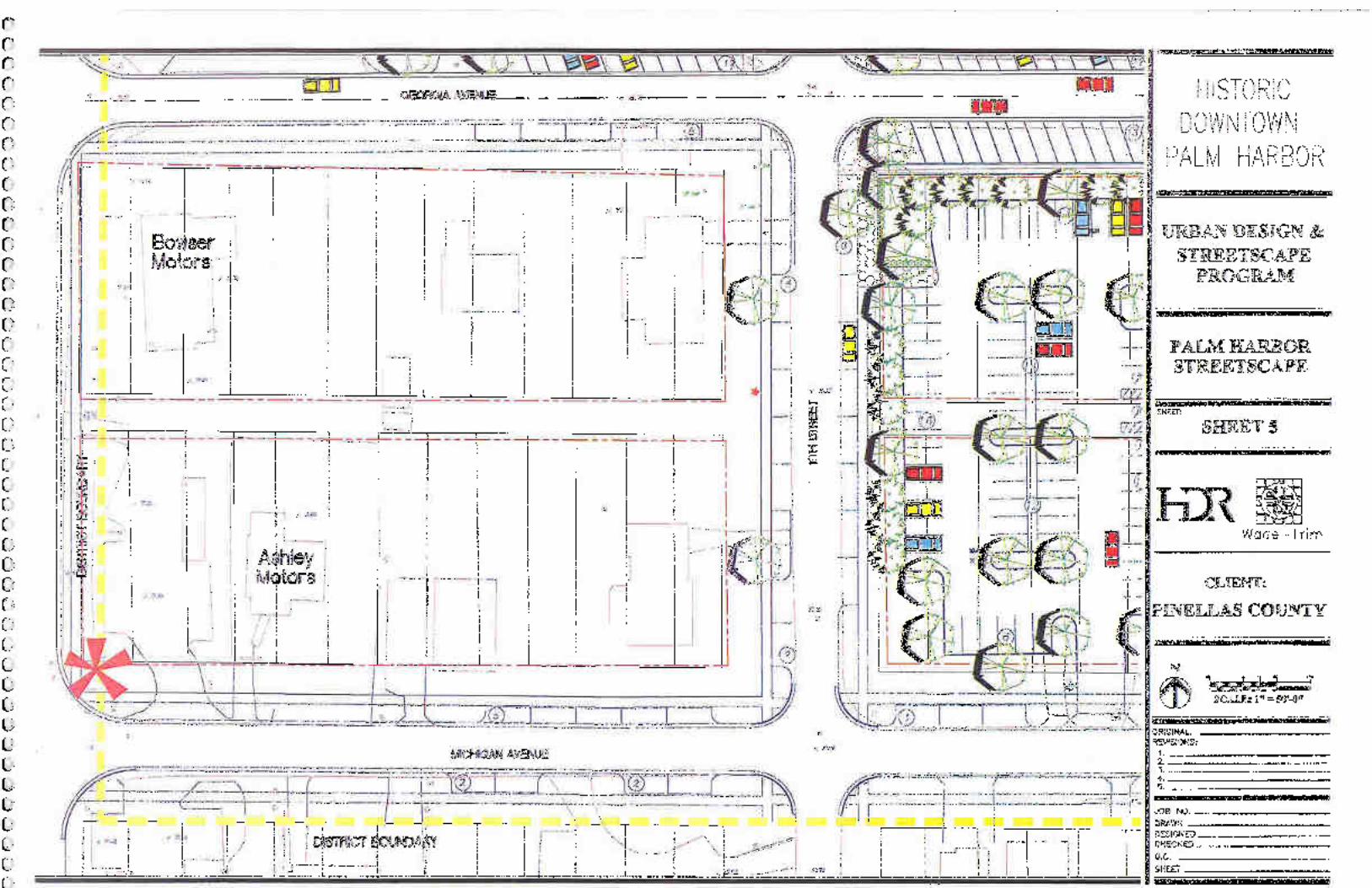
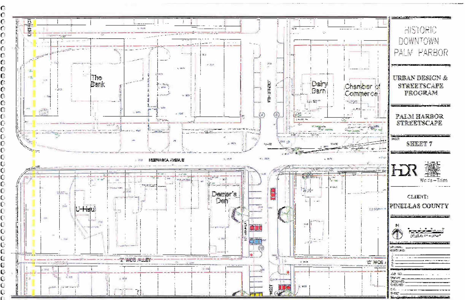
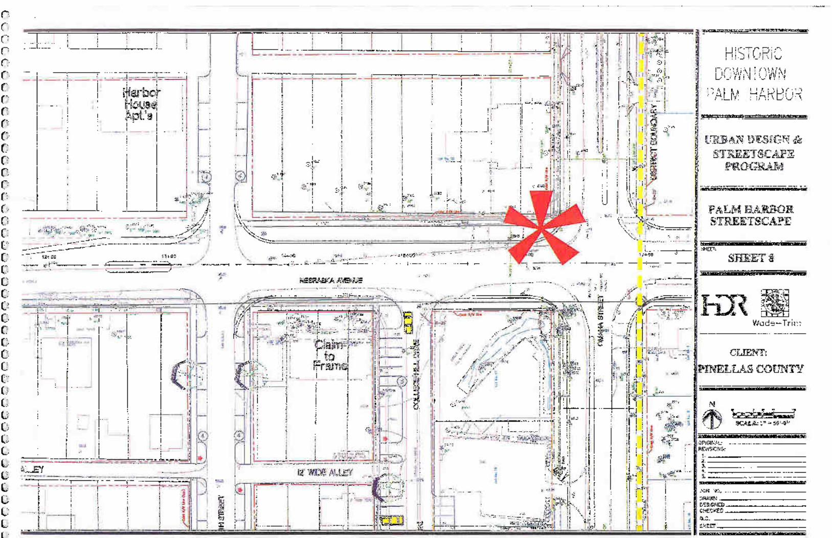
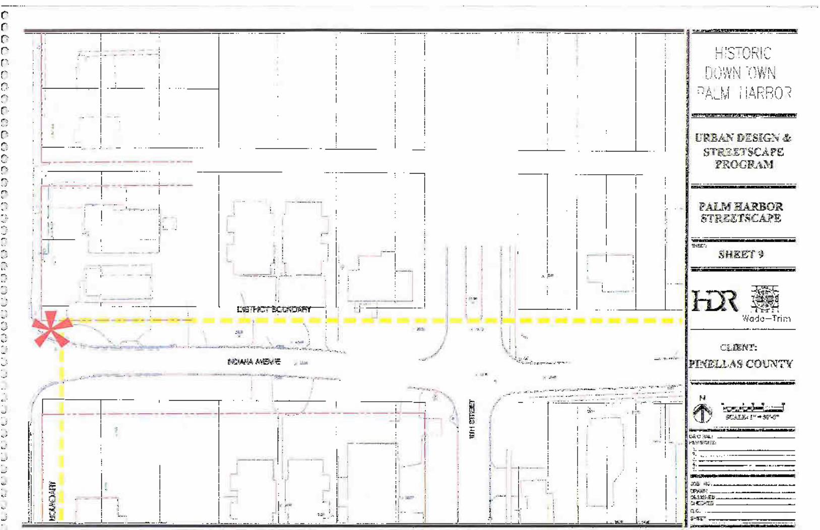
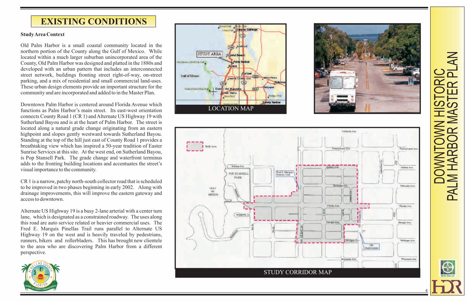
Study Area Context
Old Palm Harbor is a small coastal community located in the northern portion of the County along the Gulf of Mexico. While located within a much larger suburban unincorporated area of the County, Old Palm Harbor was designed and platted in the 1880s and developed with an urban pattern that includes an interconnected street network, buildings fronting street right-of-way, on-street parking, and a mix of residential and small commercial land-uses. These urban design elements provide an important structure for the community and are incorporated and added to in the Master Plan.
Downtown Palm Harbor is centered around Florida Avenue which functions as Palm Harbor’s main street. Its east-west orientation connects County Road 1 (CR 1) and Alternate US Highway 19 with Sutherland Bayou and is at the heart of Palm Harbor. The street is located along a natural grade change originating from an eastern highpoint and slopes gently westward towards Sutherland Bayou. Standing at the top of the hill just east of County Road 1 provides a breathtaking view which has inspired a 50-year tradition of Easter Sunrise Services at this site. At the west end, on Sutherland Bayou, is Pop Stansell Park. The grade change and waterfront terminus adds to the fronting building locations and accentuates the street’s visual importance to the community.
CR 1 is a narrow, patchy north-south collector road that is scheduled to be improved in two phases beginning in early 2002. Along with drainage improvements, this will improve the eastern gateway and access to downtown.
Alternate US Highway 19 is a busy 2-lane arterial with a center turn lane, which is designated as a constrained roadway. The uses along this road are auto service related or heavier commercial uses. The Fred E. Marquis Pinellas Trail runs parallel to Alternate US Highway 19 on the west and is heavily traveled by pedestrians, runners, bikers and rollerbladers. This has brought new clientele to the area who are discovering Palm Harbor from a different perspective.
LOCATION MAP
STUDY CORRIDOR MAP
DO
WN
TOW
N H
ISTO
RIC
PA
LM H
AR
BO
R M
AS
TER
PLA
N
5
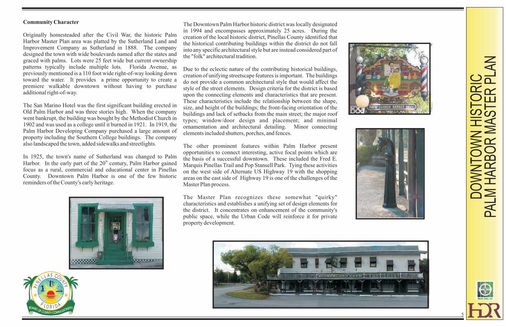
The Downtown Palm Harbor historic district was locally designated in 1994 and encompasses approximately 25 acres. During the creation of the local historic district, Pinellas County identified that the historical contributing buildings within the district do not fall into any specific architectural style but are instead considered part of the "folk" architectural tradition.
Due to the eclectic nature of the contributing historical buildings, creation of unifying streetscape features is important. The buildings do not provide a common architectural style that would affect the style of the street elements. Design criteria for the district is based upon the connecting elements and characteristics that are present. These characteristics include the relationship between the shape, size, and height of the buildings; the front-facing orientation of the buildings and lack of setbacks from the main street; the major roof types; window/door design and placement; and minimal ornamentation and architectural detailing. Minor connecting elements included shutters, porches, and fences.
The other prominent features within Palm Harbor present opportunities to connect interesting, active focal points which are the basis of a successful downtown. These included the Fred E. Marquis Pinellas Trail and Pop Stansell Park. Tying these activities on the west side of Alternate US Highway 19 with the shopping areas on the east side of Highway 19 is one of the challenges of the Master Plan process.
The Master Plan recognizes these somewhat "quirky" characteristics and establishes a unifying set of design elements for the district. It concentrates on enhancement of the community's public space, while the Urban Code will reinforce it for private property development.
Community Character
Originally homesteaded after the Civil War, the historic Palm Harbor Master Plan area was platted by the Sutherland Land and Improvement Company as Sutherland in 1888. The company designed the town with wide boulevards named after the states and graced with palms. Lots were 25 feet wide but current ownership patterns typically include multiple lots. Florida Avenue, as previously mentioned is a 110 foot wide right-of-way looking down toward the water. It provides a prime opportunity to create a premiere walkable downtown without having to purchase additional right-of-way.
The San Marino Hotel was the first significant building erected in Old Palm Harbor and was three stories high. When the company went bankrupt, the building was bought by the Methodist Church in 1902 and was used as a college until it burned in 1921. In 1919, the Palm Harbor Developing Company purchased a large amount of property including the Southern College buildings. The company also landscaped the town, added sidewalks and streetlights.
In 1925, the town's name of Sutherland was changed to Palm th
Harbor. In the early part of the 20 century, Palm Harbor gained focus as a rural, commercial and educational center in Pinellas County. Downtown Palm Harbor is one of the few historic reminders of the County's early heritage.
DO
WN
TOW
N H
ISTO
RIC
PA
LM H
AR
BO
R M
AS
TER
PLA
N
6
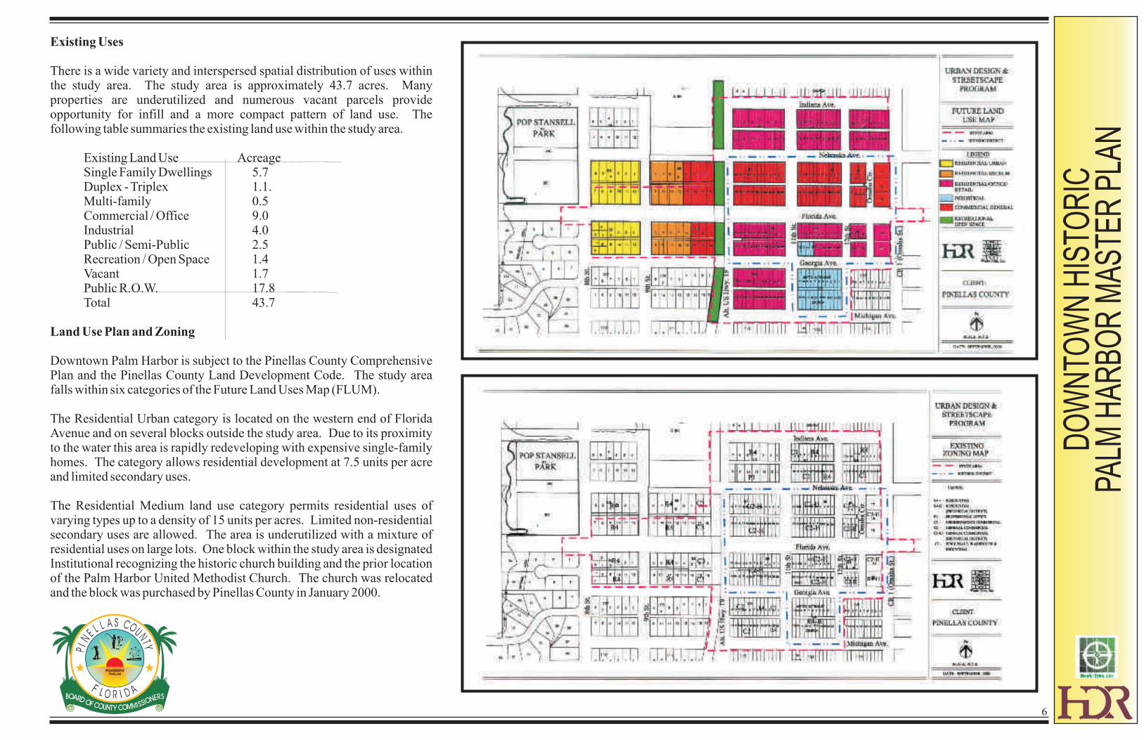
Existing Uses
There is a wide variety and interspersed spatial distribution of uses within the study area. The study area is approximately 43.7 acres. Many properties are underutilized and numerous vacant parcels provide opportunity for infill and a more compact pattern of land use. The following table summaries the existing land use within the study area.
Existing Land Use AcreageSingle Family Dwellings 5.7Duplex - Triplex 1.1.Multi-family 0.5Commercial / Office 9.0Industrial 4.0Public / Semi-Public 2.5Recreation / Open Space 1.4Vacant 1.7Public R.O.W. 17.8Total 43.7
Land Use Plan and Zoning
Downtown Palm Harbor is subject to the Pinellas County Comprehensive Plan and the Pinellas County Land Development Code. The study area falls within six categories of the Future Land Uses Map (FLUM).
The Residential Urban category is located on the western end of Florida Avenue and on several blocks outside the study area. Due to its proximity to the water this area is rapidly redeveloping with expensive single-family homes. The category allows residential development at 7.5 units per acre and limited secondary uses.
The Residential Medium land use category permits residential uses of varying types up to a density of 15 units per acres. Limited non-residential secondary uses are allowed. The area is underutilized with a mixture of residential uses on large lots. One block within the study area is designated Institutional recognizing the historic church building and the prior location of the Palm Harbor United Methodist Church. The church was relocated and the block was purchased by Pinellas County in January 2000.
DO
WN
TOW
N H
ISTO
RIC
PA
LM H
AR
BO
R M
AS
TER
PLA
N
The majority of the study area is categorized as Residential/Office/Retail. This category permits various zoning districts and a broad array of uses from residential to mini-storage warehousing at a Floor Area Ratio (FAR) of .2 to .3.
The blocks located along the west side of Alternate US Highway 19 and on the north side of Florida Avenue are categorized as Commercial General (CG). This allows for a broad range of commercial uses, including heavier commercial uses such as certain types of warehousings and vehicle repair and at an FAR of .35 to .50.
The Pinellas County Planning Department conducted a survey of the existing FAR's in the study area. They range from 0.2 to 0.6 FAR.
Downtown Palm Harbor contains the following zoning districts:
R-4, One, Two and Three-Family Residential District
P-1, General Professional Office District
C-1, Neighborhood Commercial District
C-2, General Retail Commercial and Limited Services District
C-3, Commercial, Wholesale, Warehousing and Industrial Support District
M-I, Light Manufacturing and Industry
H, Historic Preservation Overlay District
7
DO
WN
TOW
N H
ISTO
RIC
PA
LM H
AR
BO
R M
AS
TER
PLA
N
8
Infrastructure
Roadways and Drainage
The primary purpose of the Master Plan is to add aesthetic and functional value to the study area. In order to do so the overall infrastructure will be vastly improved. Currently, the streets in Palm Harbor are asphalt and are showing their age. The sidewalks and drainage systems are piecemeal. Drainage is not channelized and is predominantly an open system flowing to the lowest elevations.
On Florida Avenue the crown of the road is higher than the thresholds of the buildings in many cases. The roadways are constructed as rural sections, meaning there are no curbs to separate vehicle and pedestrian traffic. The existing conditions do not delineate clear travel lanes for cars. This, the lack of curbing and the increasing numbers of bicyclists and rollerbladers from the Fred E. Marquis Pinellas Trail create a safety problem.
On a positive note, the rights-of-way within the study area have sufficient width so that the County will not have to purchase additional property. The right-of-way on Florida Avenue is 110 feet. Almost every block has been platted with 20 feet alleys. Many of these are currently unpaved or are improved with shell. The County is reconstructing County Road 1 which will provide much needed drainage improvements to be constructed prior to the initiation of this project.
Public utilities are adequate. The overhead lines create an obstruction to water views and detract from the aesthetics of the area. The possibility of placing these lines underground is discussed further in the PER Report.
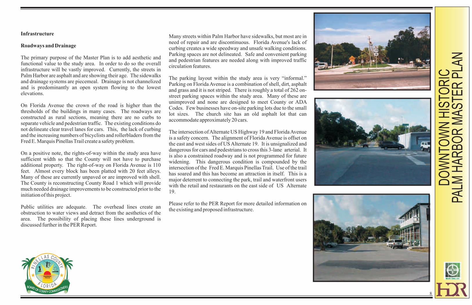
Many streets within Palm Harbor have sidewalks, but most are in need of repair and are discontinuous. Florida Avenue's lack of curbing creates a wide speedway and unsafe walking conditions. Parking spaces are not delineated. Safe and convenient parking and pedestrian features are needed along with improved traffic circulation features.
The parking layout within the study area is very “informal.” Parking on Florida Avenue is a combination of shell, dirt, asphalt and grass and it is not striped. There is roughly a total of 262 on-street parking spaces within the study area. Many of these are unimproved and none are designed to meet County or ADA Codes. Few businesses have on-site parking lots due to the small lot sizes. The church site has an old asphalt lot that can accommodate approximately 20 cars.
The intersection of Alternate US Highway 19 and Florida Avenue is a safety concern. The alignment of Florida Avenue is offset on the east and west sides of US Alternate 19. It is unsignalized and dangerous for cars and pedestrians to cross this 3-lane arterial. It is also a constrained roadway and is not programmed for future widening. This dangerous condition is compounded by the intersection of the Fred E. Marquis Pinellas Trail. Use of the trail has soared and this has become an attraction in itself. This is a major deterrent to connecting the park, trail and waterfront users with the retail and restaurants on the east side of US Alternate 19.
Please refer to the PER Report for more detailed information on the existing and proposed infrastructure.
DO
WN
TOW
N H
ISTO
RIC
PA
LM H
AR
BO
R M
AS
TER
PLA
N
Infrastructure
Roadways and Drainage
The roadway network serving Downtown Palm Harbor includes an arterial facility (Alternate US Highway 19) and two collector roads (Nebraska Avenue and CR 1). Alternate US Highway 19 is a two-lane divided facility within a 60 foot right of way and there are no plans to upgrade this facility. In 2000, there was an average of 25,370 vehicle trips each day on Alternate 19 in the vicinity of Palm Harbor, resulting in a level of service (LOS) of “F”. This traffic volume, along with the fact that there are no plans to improve this arterial roadway, has resulted in
Alternate 19 being designated a constrained corridor from Downtown Clearwater to Klosterman Road. This stretch of Alternate 19 includes that portion passing through Downtown Palm Harbor. The constrained designation recognizes that the roadway is operating at a deficient level of service under current and future conditions, and capacity improvements necessary to alleviate the deficient LOS conditions are precluded due to policy or physical constraints. CR 1 is a north-south County roadway that extends from south county to just north of Downtown Palm Harbor. This road corridor is continuous with the exception of one gap in Clearwater. This missing stretch of CR 1 is scheduled to be constructed beginning on 2002. North of Tampa Road and along the east end of Downtown Palm Harbor, CR 1 (or Omaha Street) is currently a two-lane undivided road. With the opening of Palm Harbor University
High School, traffic on CR 1 through Old Palm Harbor has increased over the past few years. In 2000, there was an average of 7,057 vehicle trips each day on CAR q just north of Nebraska Avenue, resulting in a level of service of “B”. Improvements to this road, scheduled to start in early 2002, will results in CR 1 being upgraded to a two-lane divided facility with grassy medians separating the lanes of traffic. These improvements will include construction of a regional stormwater treatment facility located west of Alternate 19 just north of Downtown Palm Harbor. This facility has been designed to also treat all stormwater generated by development within Downtown Palm Harbor east of Alternate US Highway 19 with the beneficial result that small isolated on-site treatment facilities will not be required within Downtown Palm Harbor.
Nebraska Avenue is a two-lane undivided County collector road that connects Alternate US Highway 19 with US Highway 19 approximately 1.7 miles to the east. Except for the west and east ends this road passes through residential areas and is bordered by numerous oak trees. The rural and scenic character of this roadway prompted the Pinellas County Board of County Commissioners in 1999 to designate Nebraska Avenue from CR 1 to Belcher Road as a scenic/non-commercial corridor. This designation is designed to protect the scenic character of the roadway and preserve its traffic carrying capacity by strictly limiting the intensity and density of development adjacent to the roadway. In 2000, there was an average of 7,202 vehicle trips per day on Nebraska Avenue, resulting in a level of service of “B”. There are no current or
anticipated level of service issues associated with Nebraska Avenue, and there are no plans to upgrade this facility east of CR 1. As part of the scheduled improvements to CR 1, Nebraska Avenue will be improved between CRA 1 and Alternated US Highway 19; however, any improvements to this roadway must be compatible with its location within Downtown Palm Harbor and the emphasis on sage pedestrian activity. Due to the age of much of the development located in Downtown Palm Harbor, most properties do not contain on-site stormwater treatment systems. As redevelopment occurs on the small sites located in Downtown, however, it has had to utilize a portion of these small sites for stormwater treatment. To encourage the more compact development pattern that has historically occurred in Downtown Palm Harbor, Pinellas County has designed a regional retention facility to include adequate treatment capacity for downtown properties as well as the improvements to CR 1. Construction of this facility as part of the CR 1 improvements will allow redevelopment to occur without having to sacrifice valuable acreage for on-site stormwater treatment systems. The main collection system will be located under Georgia Avenue, cross Alternate US Highway 19, and then follow this highway north to the regional treatment facility.
Sanitary Sewer and Potable Water Facilities
Properties in Downtown Palm Harbor are provided with potable water service and sanitary sewer service by Pinellas County Utilities. These utility systems are functioning adequately. Pinellas County Utilities compared the increased demands associated with the maximum development anticipated under the Master Plan with the existing sanitary sewer collection system and determined that the existing collection system is adequate to handle the increase. While Pinellas County Utilities has determined that the potable water lines are adequate to handle the increased demand associated with the anticipated retail, office and residential development downtown, the Fire Chief of Palm Harbor Fire Rescue will need to determine whether the existing 2-inch water pipes are adequate for fire protection. The Fire Chief has already notified Pinellas County that Downtown Palm Harbor is a little short on fire hydrants and that any new construction may require additional fire hydrants to be installed. Pinellas County Utilities will be installing a reclaimed water line when CR 1 is improved through Old Palm Harbor. Distribution lines will be constructed in the public rights-of-way in Downtown Palm Harbor to provide water for irrigating the streetscape plant materials.
9

PARTICIPATION PROCESS
DO
WN
TOW
N H
ISTO
RIC
PA
LM H
AR
BO
R M
AS
TER
PLA
N
10
The development of the Master Plan 2000 spanned six months from March to September 2000. Different meeting formats were utilized by the consultant based upon the topic and decisions desired. The meetings were open to all and were well advertised through direct mailing and media coverage.
In addition to the 3-1/2 day design workshop/charrette, several other meetings were conducted to solicit ideas and opinions from stakeholders and to refine the Master Plan and new code regulations.
Public Meetings
March 27, 2000 Main Street Field MeetingMay 1, 2000 Issues WorkshopMay 22, 2000 Session 1 Public PresentationMay 23, 2000 Session 2 Main Street CommitteesMay 23, 2000 Session 3 Walking TourMay 23, 2000 Session 4 Main Street Review BoardMay 24, 2000 Session 5 Technical InputMay 24, 2000 Session 6 Main Street Review BoardMay 25, 2000 Session 7 Public PresentationJune 13, 2000 Charette Follow-up MeetingJune 26, 2000 Streetscape/Revitalization
Code WorkshopJuly/August, 2000 Economic Restructuring Committee /
Revitalization CodeSeptember 25, 2000 Revitalization Code Workshop
As previously mentioned, many groups and individuals have been leaders in the revitalization efforts during the last decade. In addition to residents, property owners and business owners, stakeholders, including historic preservationists, Main Street members, and coordinators of the art show and other events. The Main Street Board served as the Steering Committee for this project.
Historic
Society
Citizens
Main Street BoardData Collection
Government
Agencies
Merchants
PropertyOwners
Main Street
Resource Team
PALM
HARBOR
DESIGN
TEAM
DO
WN
TOW
N H
ISTO
RIC
PA
LM H
AR
BO
R M
AS
TER
PLA
N
11
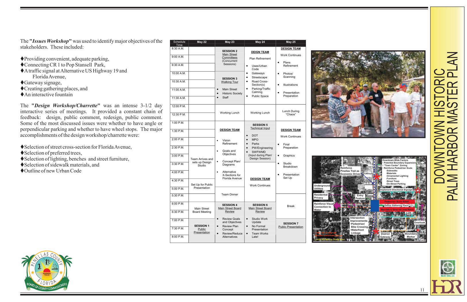
The "Issues Workshop" was used to identify major objectives of the stakeholders. These included:
tProviding convenient, adequate parking,tConnecting CR 1 to Pop Stansell Park,tA traffic signal at Alternative US Highway 19 and
Florida Avenue,tGateway signage,tCreating gathering places, andtAn interactive fountain
The "Design Workshop/Charrette" was an intense 3-1/2 day interactive series of meetings. It provided a constant chain of feedback: design, public comment, redesign, public comment. Some of the most discussed issues were whether to have angle or perpendicular parking and whether to have wheel stops. The major accomplishments of the design workshop/charrette were:
tSelection of street cross-section for Florida Avenue,tSelection of preferred trees,tSelection of lighting, benches and street furniture, tSelection of sidewalk materials, andtOutline of new Urban Code
ScheduleTime
May 22 May 23 May 24 May 25
8:30 A.M.
9:00 A.M.
9:30 A.M.
SESSION 2Main StreetCommittees(ConcurrentSessions)
10:00 A.M.
10:30 A.M.
11:00 A.M.
11:30 A.M.
SESSION 3Walking Tour
· Main Street
· Historic Society
· Staff
DEIGN TEAM
Plan Refinement
· Uses/UrbanCode
· Gateways
· Streetscape
· Road Cross-Section(s)
· Parking/TrafficCalming
· Public Space
DESIGN TEAM
Work Continues
· PlansRefinement
· Photos/Scanning
· Illustrations
· PresentationPreparation
12:00 P.M.
12:30 P.M.Working Lunch Working Lunch
Lunch During“Chaos”
1:00 P.M.
1:30 P.M.
2:00 P.M.
2:30 P.M.
3:00 P.M.
SESSION 5Technical Input
· DOT
· MPO
· Parks
· PW/Engineering
· SWFWMD(Input during Plan/Design Session)
3:30 P.M.
4:00 P.M.
Team Arrives andsets up Design
Studio
4:30 P.M.
DESIGN TEAM
· VisionRefinement
· Goals andObjectives
· Concept Plan/Diagrams
· AlternativeX-Sections forFlorida Avenue
5:00 P.M.
Set Up for PublicPresentation
DESIGN TEAM
Work Continues
· FinalPreparation
· Graphics
· StudioBreakdown
· PresentationSet Up
5:30 P.M. Team Dinner
DESIGN TEAM
Work Continues
6:00 P.M.
6:30 P.M.
Main StreetBoard Meeting
Break
7:00 P.M.
7:30 P.M.
8:00 P.M.
SESSION 1Public
Presentation
SESSION 4Main Street Board
Review
· Review Goalsand Objectives
· Review PlanConcept
· Review/ReduceAlternatives
SESSION 6Main Street Board
Review
· Studio WorkUpdate
· No FormalPresentation
· Team WorksLate!
SESSION 7Public Presentation
Limits of Conceptual
Streetscape/Urban Design
Limits of Parking Study Area
**
* District
Gateway
Boundary
Marker
Entry
Feature
Intersection
Improvements
•Pedestrian/
Bike Crossing
•Waterfront
Linkage
Reinforce
Pinellas Trail as
Economic Driver
Underground
Utilities
Residential
Privacy
Reinforce Visual
Connection to
Water
Overlook
Pedestrian Scale Retail
Mandatory Ground-Level Retail
Implement Directional Signage
Define Gathering Place
Downtown-Wide Factors
• Potential Boundary Expansion
• “Town Center” Zoning
• Reinforce Pedestrian Scale
-Sidewalks
-Materials
-Ornamental Lighting
-Furniture
-Street Trees
-On-Street Parking
CONCEPT PLAN
DO
WN
TOW
N H
ISTO
RIC
PA
LM H
AR
BO
R M
AS
TER
PLA
N
12
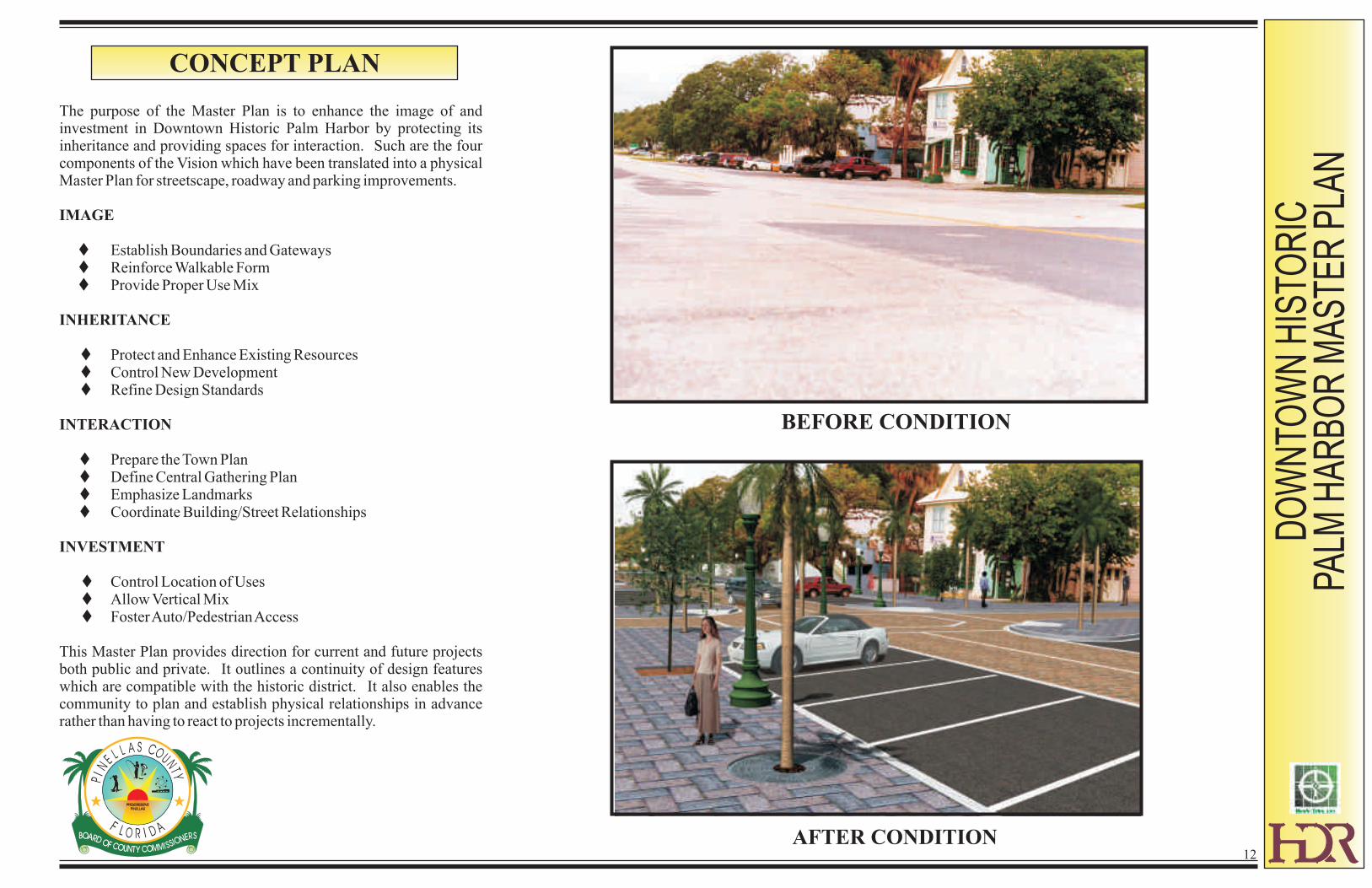
The purpose of the Master Plan is to enhance the image of and investment in Downtown Historic Palm Harbor by protecting its inheritance and providing spaces for interaction. Such are the four components of the Vision which have been translated into a physical Master Plan for streetscape, roadway and parking improvements.
IMAGE
tEstablish Boundaries and GatewaystReinforce Walkable FormtProvide Proper Use Mix
INHERITANCE
tProtect and Enhance Existing ResourcestControl New DevelopmenttRefine Design Standards
INTERACTION
tPrepare the Town PlantDefine Central Gathering PlantEmphasize LandmarkstCoordinate Building/Street Relationships
INVESTMENT
tControl Location of UsestAllow Vertical MixtFoster Auto/Pedestrian Access
This Master Plan provides direction for current and future projects both public and private. It outlines a continuity of design features which are compatible with the historic district. It also enables the community to plan and establish physical relationships in advance rather than having to react to projects incrementally.
BEFORE CONDITION
AFTER CONDITION
DO
WN
TOW
N H
ISTO
RIC
PA
LM H
AR
BO
R M
AS
TER
PLA
N
13
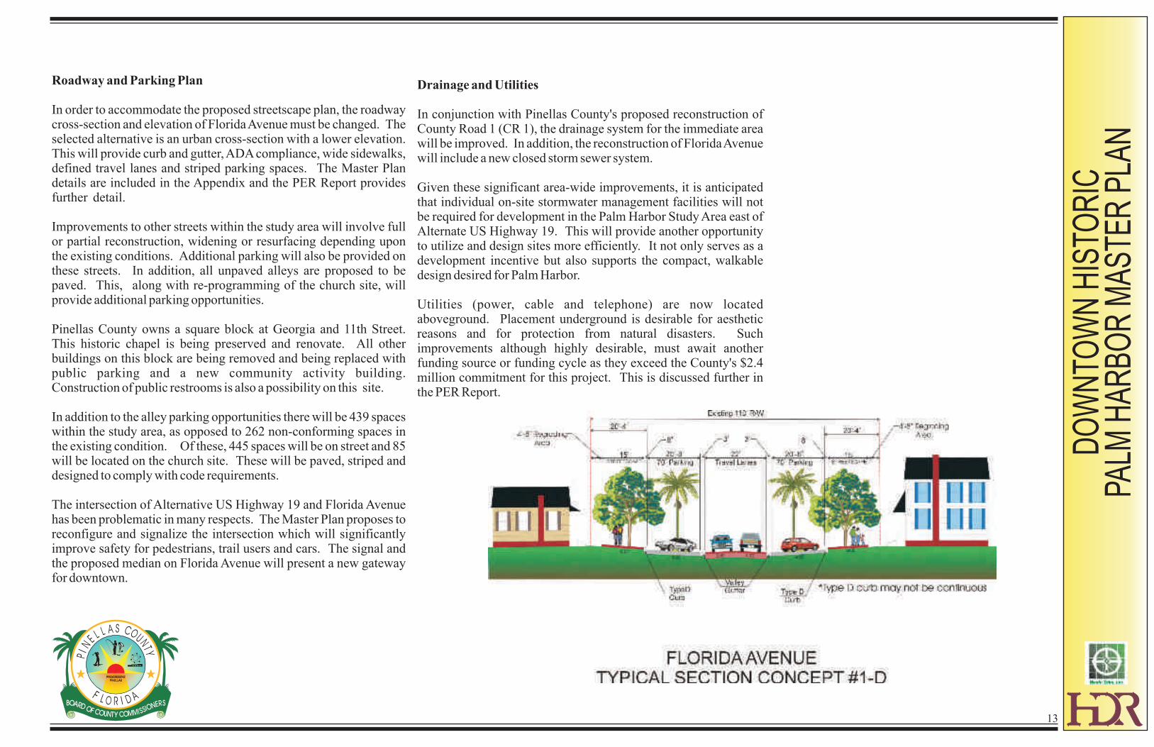
Roadway and Parking Plan
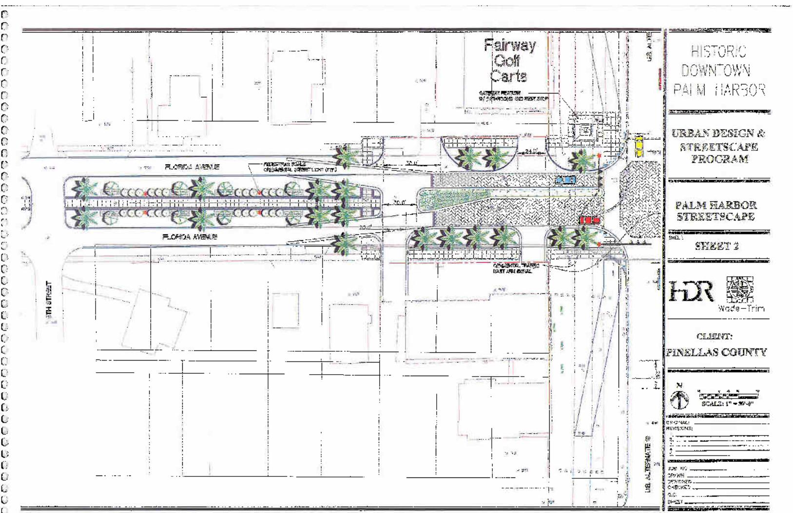
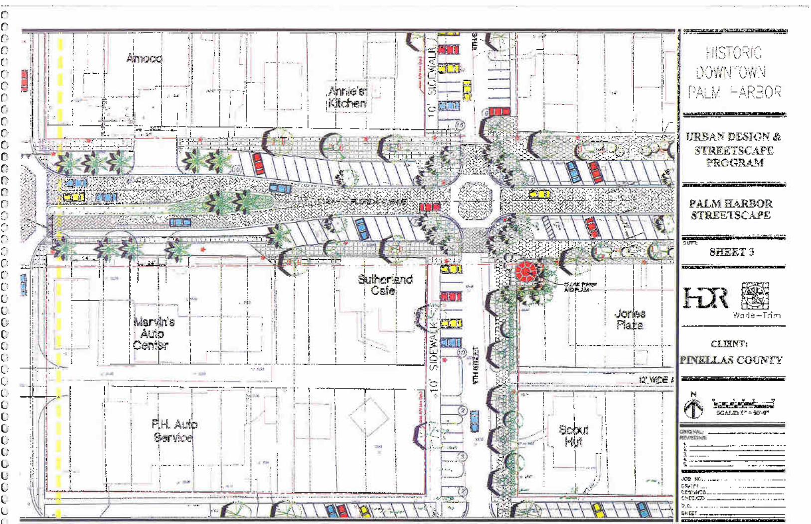
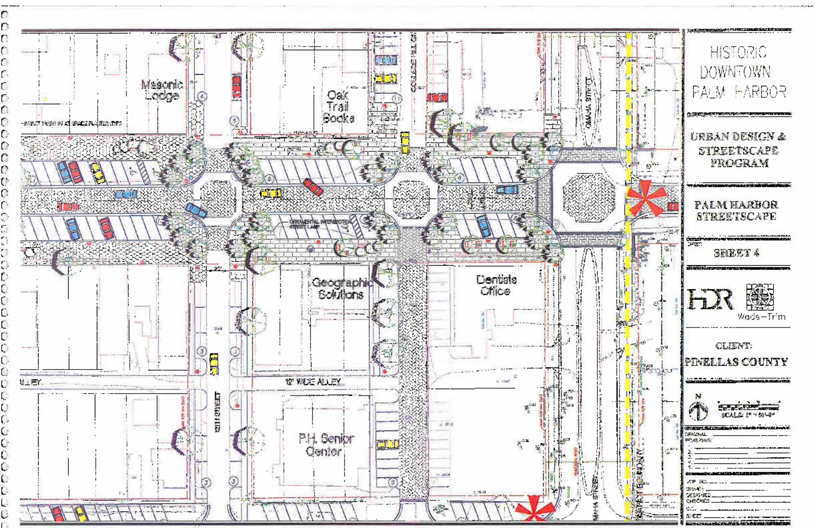
In order to accommodate the proposed streetscape plan, the roadway cross-section and elevation of Florida Avenue must be changed. The selected alternative is an urban cross-section with a lower elevation. This will provide curb and gutter, ADA compliance, wide sidewalks, defined travel lanes and striped parking spaces. The Master Plan details are included in the Appendix and the PER Report provides further detail.
Improvements to other streets within the study area will involve full or partial reconstruction, widening or resurfacing depending upon the existing conditions. Additional parking will also be provided on these streets. In addition, all unpaved alleys are proposed to be paved. This, along with re-programming of the church site, will provide additional parking opportunities.
Pinellas County owns a square block at Georgia and 11th Street. This historic chapel is being preserved and renovate. All other buildings on this block are being removed and being replaced with public parking and a new community activity building. Construction of public restrooms is also a possibility on this site.
In addition to the alley parking opportunities there will be 439 spaces within the study area, as opposed to 262 non-conforming spaces in the existing condition. Of these, 445 spaces will be on street and 85 will be located on the church site. These will be paved, striped and designed to comply with code requirements.
The intersection of Alternative US Highway 19 and Florida Avenue has been problematic in many respects. The Master Plan proposes to reconfigure and signalize the intersection which will significantly improve safety for pedestrians, trail users and cars. The signal and the proposed median on Florida Avenue will present a new gateway for downtown.
Drainage and Utilities
In conjunction with Pinellas County's proposed reconstruction of County Road 1 (CR 1), the drainage system for the immediate area will be improved. In addition, the reconstruction of Florida Avenue will include a new closed storm sewer system.
Given these significant area-wide improvements, it is anticipated that individual on-site stormwater management facilities will not be required for development in the Palm Harbor Study Area east of Alternate US Highway 19. This will provide another opportunity to utilize and design sites more efficiently. It not only serves as a development incentive but also supports the compact, walkable design desired for Palm Harbor.
Utilities (power, cable and telephone) are now located aboveground. Placement underground is desirable for aesthetic reasons and for protection from natural disasters. Such improvements although highly desirable, must await another funding source or funding cycle as they exceed the County's $2.4 million commitment for this project. This is discussed further in the PER Report.
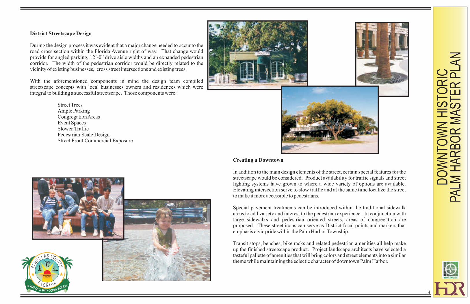
District Streetscape Design
During the design process it was evident that a major change needed to occur to the road cross section within the Florida Avenue right of way. That change would provide for angled parking, 12’-0” drive aisle widths and an expanded pedestrian corridor. The width of the pedestrian corridor would be directly related to the vicinity of existing businesses, cross street intersections and existing trees.
With the aforementioned components in mind the design team compiled streetscape concepts with local businesses owners and residences which were integral to building a successful streetscape. Those components were:
Street TreesAmple ParkingCongregation AreasEvent SpacesSlower TrafficPedestrian Scale DesignStreet Front Commercial Exposure
Creating a Downtown
In addition to the main design elements of the street, certain special features for the streetscape would be considered. Product availability for traffic signals and street lighting systems have grown to where a wide variety of options are available. Elevating intersection serve to slow traffic and at the same time localize the street to make it more accessible to pedestrians.
Special pavement treatments can be introduced within the traditional sidewalk areas to add variety and interest to the pedestrian experience. In conjunction with large sidewalks and pedestrian oriented streets, areas of congregation are proposed. These street icons can serve as District focal points and markers that emphasis civic pride within the Palm Harbor Township.
Transit stops, benches, bike racks and related pedestrian amenities all help make up the finished streetscape product. Project landscape architects have selected a tasteful pallette of amenities that will bring colors and street elements into a similar theme while maintaining the eclectic character of downtown Palm Harbor.
DO
WN
TOW
N H
ISTO
RIC
PA
LM H
AR
BO
R M
AS
TER
PLA
N
14
DO
WN
TOW
N H
ISTO
RIC
PA
LM H
AR
BO
R M
AS
TER
PLA
N
15
ORNAMENTAL COBRAHEAD STREET
LIGHT
ORIENTAL TRAFFIC LIGHT
ORNAMENTAL BOLLARD LIGHTS
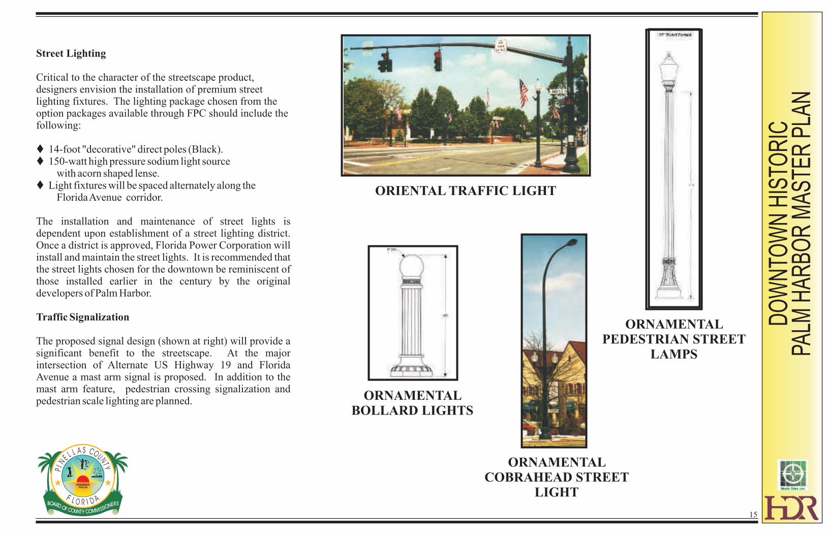
Street Lighting
Critical to the character of the streetscape product, designers envision the installation of premium street lighting fixtures. The lighting package chosen from the option packages available through FPC should include the following:
t 14-foot "decorative" direct poles (Black).t 150-watt high pressure sodium light source with acorn shaped lense.t Light fixtures will be spaced alternately along the Florida Avenue corridor.
The installation and maintenance of street lights is dependent upon establishment of a street lighting district. Once a district is approved, Florida Power Corporation will install and maintain the street lights. It is recommended that the street lights chosen for the downtown be reminiscent of those installed earlier in the century by the original developers of Palm Harbor.
Traffic Signalization
The proposed signal design (shown at right) will provide a significant benefit to the streetscape. At the major intersection of Alternate US Highway 19 and Florida Avenue a mast arm signal is proposed. In addition to the mast arm feature, pedestrian crossing signalization and pedestrian scale lighting are planned.
ORNAMENTAL PEDESTRIAN STREET
LAMPS
DO
WN
TOW
N H
ISTO
RIC
PA
LM H
AR
BO
R M
AS
TER
PLA
N
16
LOOP BIKE RACK
WATER FOUNTAIN
ORNAMENTAL STREET BENCH
TREE GATE
PLANTER
ORNAMENTAL TRASH
RECEPTACLE
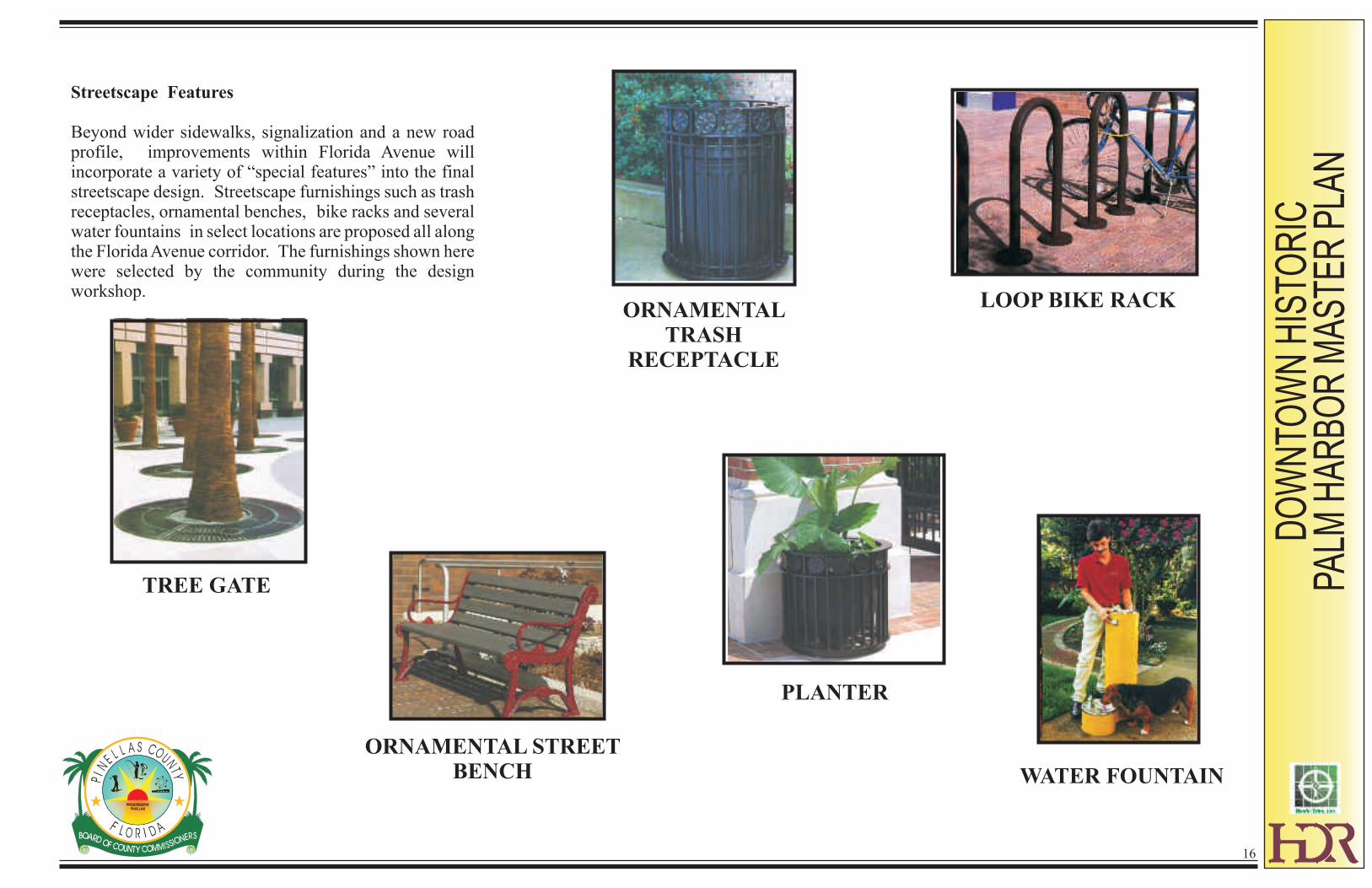
Streetscape Features
Beyond wider sidewalks, signalization and a new road profile, improvements within Florida Avenue will incorporate a variety of “special features” into the final streetscape design. Streetscape furnishings such as trash receptacles, ornamental benches, bike racks and several water fountains in select locations are proposed all along the Florida Avenue corridor. The furnishings shown here were selected by the community during the design workshop.
DO
WN
TOW
N H
ISTO
RIC
PA
LM H
AR
BO
R M
AS
TER
PLA
N
17
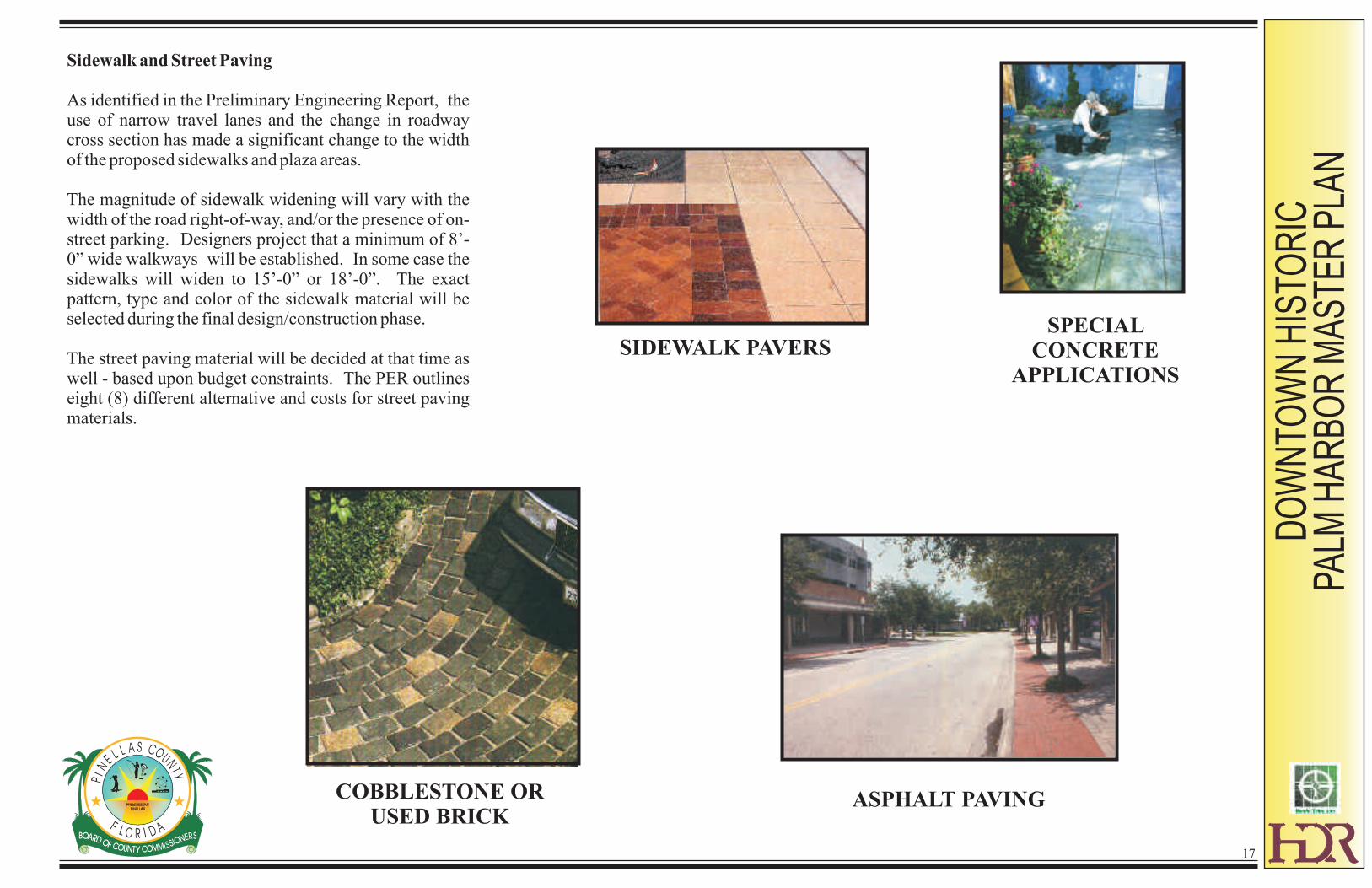
SPECIAL CONCRETE
APPLICATIONS
COBBLESTONE OR USED BRICK
SIDEWALK PAVERS
Sidewalk and Street Paving
As identified in the Preliminary Engineering Report, the use of narrow travel lanes and the change in roadway cross section has made a significant change to the width of the proposed sidewalks and plaza areas.
The magnitude of sidewalk widening will vary with the width of the road right-of-way, and/or the presence of on-street parking. Designers project that a minimum of 8’-0” wide walkways will be established. In some case the sidewalks will widen to 15’-0” or 18’-0”. The exact pattern, type and color of the sidewalk material will be selected during the final design/construction phase.
The street paving material will be decided at that time as well - based upon budget constraints. The PER outlines eight (8) different alternative and costs for street paving materials.
ASPHALT PAVING

DO
WN
TOW
N H
ISTO
RIC
PA
LM H
AR
BO
R M
AS
TER
PLA
N
18
Botanical Name Common NameLandscape Materials
Trees
Cornus florida DogwoodIlex cassine Dahoon HollyIlex opaca American HollyIlex x attenuata 'East Palatka' East Palatka HollyIlex x attenuata 'Savannah' Savannah HollyIlex vomitoria Yaupon HollyLagerstroemia indica Crape MyrtleLiquidambar styraciflua Sweet GumMagnolia grandiflora Southern MagnoliaQuercus laurifolia Laurel OakQuercus virginiana Live OakUlmus alata Winged Elm
Palms
Sabal palmetto Cabbage PalmAccoelorrhaphe wrightii Paurotis Palm (needs ample water)
Accents
Cercis canadensis RedbudCrinum spp. Spider LilyCycas revoluta Pygmy Date PalmPrunus angustifolia Chickasaw PlumZamia Floridana Coontie
ShrubsForestiera segregata Florida PrivetIlex cornuta 'burfordii' Chinese HollyIlex cornuta 'rotunda' Round Chinese HollyIlex vomitoria 'schillings' Dwarf Yaupon HollyIllicium parviflorum AniseRhaphiolepis indica Indian HawthorneViburnum obovatum Walter’s ViburnumViburnum odoratissimum Sweet ViburnumViburnum suspensum Sandankwa Viburnum

DO
WN
TOW
N H
ISTO
RIC
PA
LM H
AR
BO
R M
AS
TER
PLA
N
19
Botanical Name Common Name
Ground CoversJuniperus spp. JuniperLiriope muscari 'evrgrn gnt' Evergreen GiantOphiopogon japonicus Mondo GrassStachytarpheta jamaicensis Trailing PorterweedZamia floridana CoontieZamia furfuracea Cardboard Palm
Ornamental GrassesMiscanthus sinensis MiscanthusMuhlenbergia capillaris Muhly GrassPennisetum setaceum Fountain GrassPennisetum setaceum 'rubrum' Red Fountain GrassTripsacum floridana Dwarf Fakahatchee Grass
OrnamentalsLantana species Sterile subspecies or varieties
such as “Gold Mound”Lantana montevidensisPentas lanceolata Pentas*Plumbago 'Imperial Blue' PlumbagoAnnuals Annuals
* cold sensitive

DO
WN
TOW
N H
ISTO
RIC
PA
LM H
AR
BO
R M
AS
TER
PLA
N
20
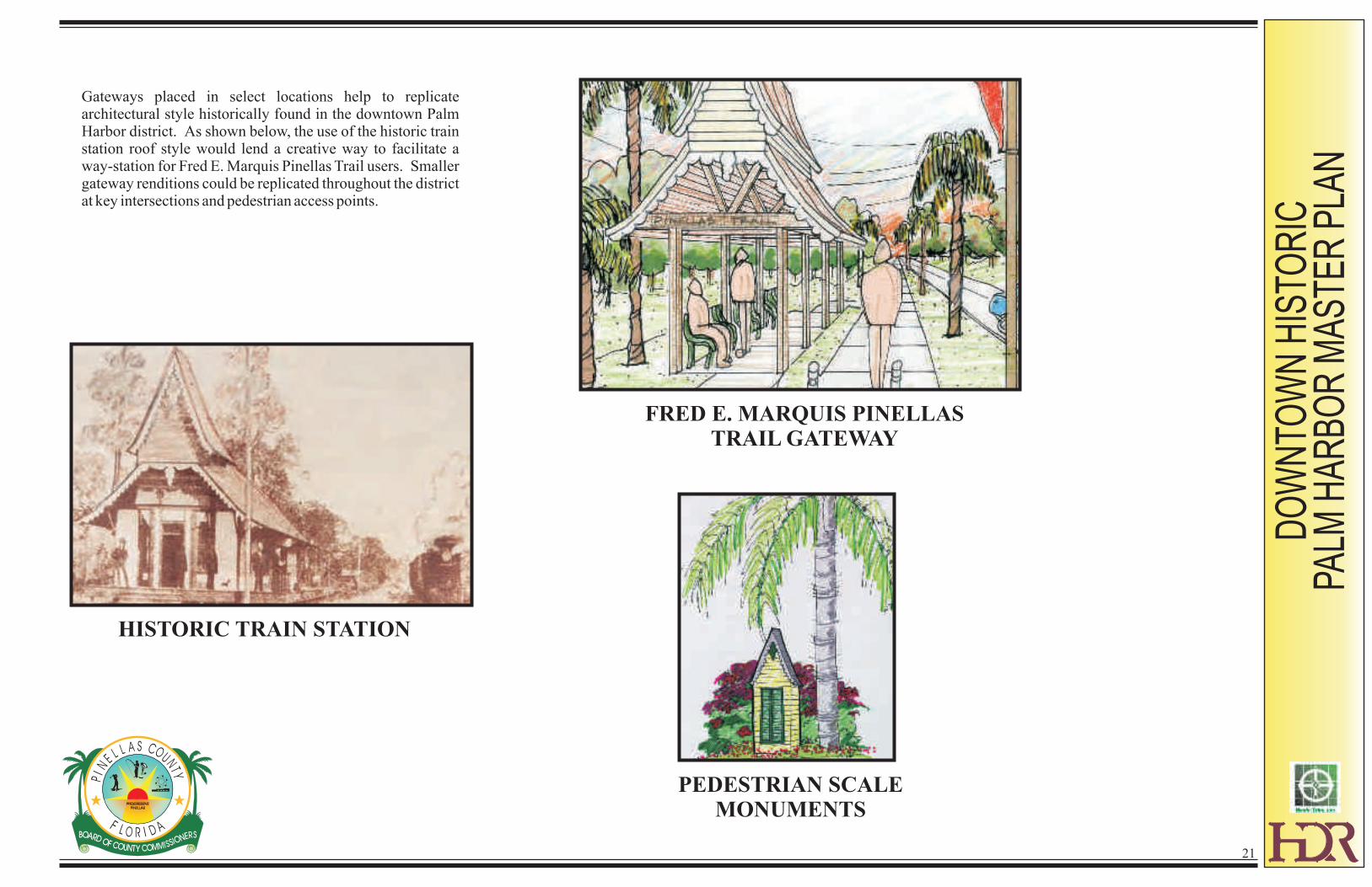
Streetscape Gateways and Elements
In the design of the Palm Harbor downtown district, certain architectural gateways and elements were included. The motivating forces behind each of these elements were historically driven. Through research and community input references were found to such historic features as the Palm Harbor University, Orange Belt Train Depot, Intersection Markers, and significant trees such as the Canary Island Date Palm.
DO
WN
TOW
N H
ISTO
RIC
PA
LM H
AR
BO
R M
AS
TER
PLA
N
Gateways placed in select locations help to replicate architectural style historically found in the downtown Palm Harbor district. As shown below, the use of the historic train station roof style would lend a creative way to facilitate a way-station for Fred E. Marquis Pinellas Trail users. Smaller gateway renditions could be replicated throughout the district at key intersections and pedestrian access points.
FRED E. MARQUIS PINELLAS TRAIL GATEWAY
HISTORIC TRAIN STATION
PEDESTRIAN SCALE MONUMENTS
21
DO
WN
TOW
N H
ISTO
RIC
PA
LM H
AR
BO
R M
AS
TER
PLA
N
22
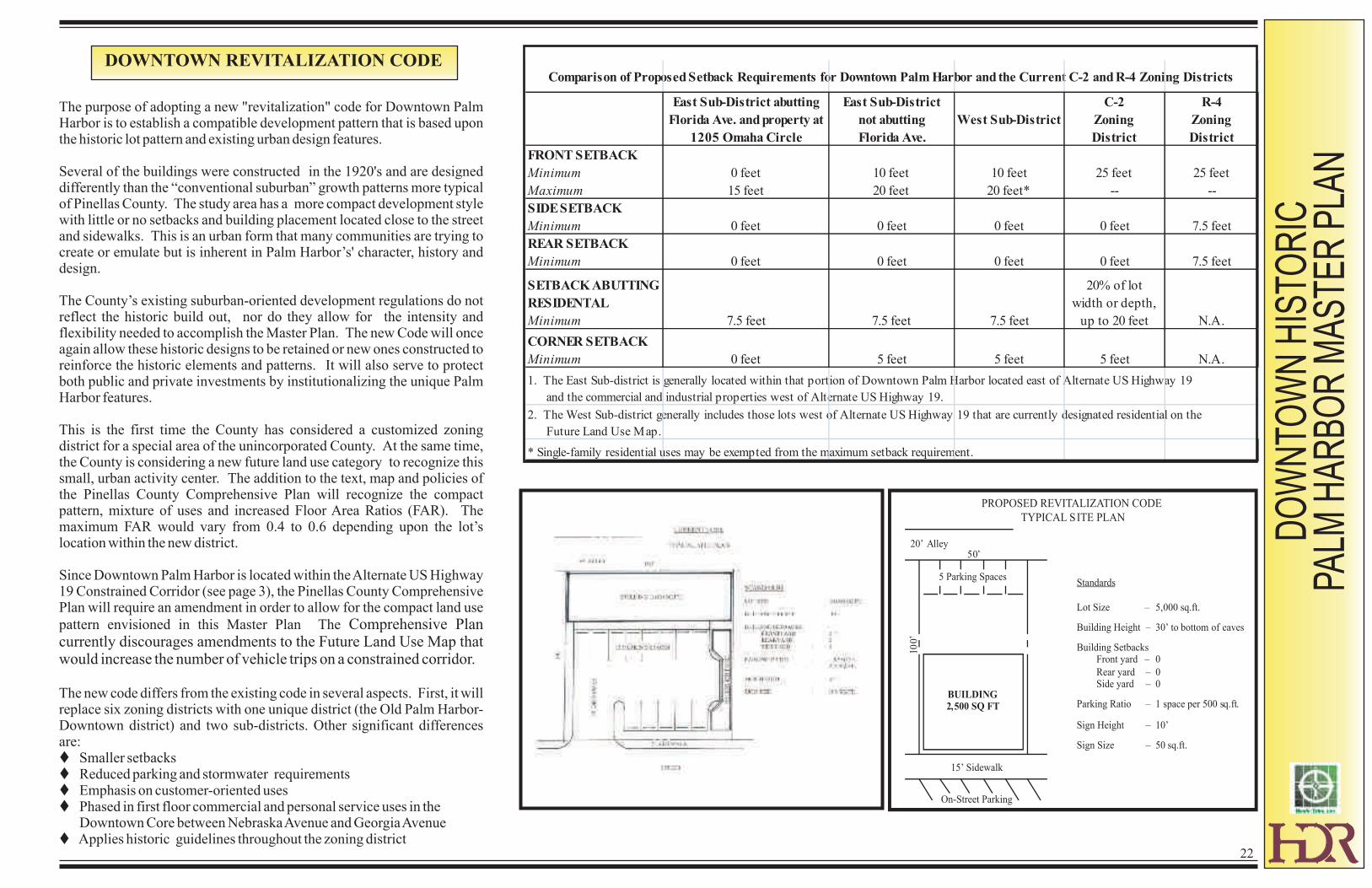
The purpose of adopting a new "revitalization" code for Downtown Palm Harbor is to establish a compatible development pattern that is based upon the historic lot pattern and existing urban design features.
Several of the buildings were constructed in the 1920's and are designed differently than the “conventional suburban” growth patterns more typical of Pinellas County. The study area has a more compact development style with little or no setbacks and building placement located close to the street and sidewalks. This is an urban form that many communities are trying to create or emulate but is inherent in Palm Harbor’s' character, history and design.
The County’s existing suburban-oriented development regulations do not reflect the historic build out, nor do they allow for the intensity and flexibility needed to accomplish the Master Plan. The new Code will once again allow these historic designs to be retained or new ones constructed to reinforce the historic elements and patterns. It will also serve to protect both public and private investments by institutionalizing the unique Palm Harbor features.
This is the first time the County has considered a customized zoning district for a special area of the unincorporated County. At the same time, the County is considering a new future land use category to recognize this small, urban activity center. The addition to the text, map and policies of the Pinellas County Comprehensive Plan will recognize the compact pattern, mixture of uses and increased Floor Area Ratios (FAR). The maximum FAR would vary from 0.4 to 0.6 depending upon the lot’s location within the new district.
Since Downtown Palm Harbor is located within the Alternate US Highway 19 Constrained Corridor (see page 3), the Pinellas County Comprehensive Plan will require an amendment in order to allow for the compact land use
pattern envisioned in this Master Plan The Comprehensive Plan currently discourages amendments to the Future Land Use Map that would increase the number of vehicle trips on a constrained corridor.
The new code differs from the existing code in several aspects. First, it will replace six zoning districts with one unique district (the Old Palm Harbor-Downtown district) and two sub-districts. Other significant differences are:t Smaller setbackst Reduced parking and stormwater requirementst Emphasis on customer-oriented usest Phased in first floor commercial and personal service uses in the Downtown Core between Nebraska Avenue and Georgia Avenuet Applies historic guidelines throughout the zoning district
DOWNTOWN REVITALIZATION CODE
East Sub-District abutting
Florida Ave. and property at
1205 Omaha Circle
East Sub-District
not abutting
Florida Ave.
West Sub-District
C-2
Zoning
District
R-4
Zoning
District
FRONT SETBACK
Minimum
Maximum
0 feet
15 feet
10 feet
20 feet
10 feet
20 feet*
25 feet
--
25 feet
--
SIDE SETBACK
Minimum 0 feet 0 feet 0 feet 0 feet 7.5 feet
REAR SETBACK
Minimum 0 feet 0 feet 0 feet 0 feet 7.5 feet
SETBACK ABUTTING
RESIDENTAL
Minimum 7.5 feet 7.5 feet 7.5 feet
20% of lot
width or depth,
up to 20 feet N.A.
CORNER SETBACK
Minimum 0 feet 5 feet 5 feet 5 feet N.A.
Comparison of Proposed Setback Requirements for Downtown Palm Harbor and the Current C-2 and R-4 Zoning Districts
1. The East Sub-district is generally located within that portion of Downtown Palm Harbor located east of Alternate US Highway 19
and the commercial and industrial properties west of Alternate US Highway 19.
2. The West Sub-district generally includes those lots west of Alternate US Highway 19 that are currently designated residential on the
Future Land Use Map.
* Single-family residential uses may be exempted from the maximum setback requirement.
PROPOSED REVITALIZATION CODE
TYPICAL SITE PLAN
Standards
Lot Size
– 5,000 sq.ft.
Building Height –
30’
to bottom
of
eaves
Building Setbacks
Front yard
–
0
Rear yard
–
0
Side yard
– 0
Parking Ratio
– 1 space per 500 sq.ft.
Sign Height
–
10’
Sign Size
–
50 sq.ft.
On-Street Parking
BUILDING
2,500 SQ FT
15’
Sidewalk
100’
20’ Alley
50’
5 Parking Spaces

USES THAT WOULD BE PERMITTED IN DOWNTOWN PALM HARBOR
Permitted UsesFORMER ZONING
DISTRICTS
OPH-D DISTRICT
(Sub-districts)
Single Family Dwellings R-4 West
Duplex and Triplex Dwellings R-4 East and West
Multiple Family Dwellings None East and West
Accessory Dwelling Units R-4, P-1, C-1, C-2 East and West
Home Occupations R-4 East and West
Bed and Breakfast Facility
(Up to 10 Guest Rooms)P-1, C-1, C-2 East and West
Offices for Professional Services P-1, C-1, C-2 East and West
Medical Clinic P-1, C-1, C-2 East*
Medical and Dental Offices P-1, C-1, C-2 East
Veterinarian's Office P-1, C-1, C-2 East*
Scientific Research and Laboratory P-1, C-1, C-2 East*
Studios for Instruction and Teaching Only P-1, C-1, C-2 East and West
Galleries for Artists, Photographers, etc. C-2 East and West
School, Public or Private P-1, C-1, C-2 East*
Funeral Homes P-1, C-1, C-2 None
Bank Facilities P-1, C-1, C-2 East
Day Care CenterR-4(SE)**, P-1,
C-1, C-2East* and West
Churches P-1, C-1, C-2 East*
Personal Services C-1, C-2 East
Retail Business or Commercial Use that serves
the immediate needs of the neighborhood
(Accessory outdoor sales)
C-1, C-2 East
Permitted UsesFORMER ZONING
DISTRICTS
OPH-D DISTRICT
(Sub-districts)
General Retail Sales (Accessory outdoor sales) C-2 East
Artisan Establishments Not Applicable East
Eating and Drinking EstablishmentsC-1 (50 seats or less)
C-2East
Alcoholic Beverage Production Facilities Not Applicable East
Outdoor Sales, Display and Rental of Vehicles,
Boats and Mobile HomesC-2 None
Hotels and Motels
(up to 30-40 units per acre)C-2 None
Veterinary Hospitals and Kennels
when entirely confined within a buildingC-2 None
Bowling Alley, Skating Rink and similar indoor
amusementsC-2 None
Indoor Theaters C-2 East*
Auto Repairs within an enclosed building C-2 None
Household Goods Repair C-2 East
Service Stations C-2 None
Wholesale Distribution Facilities within
completely enclosed buildingC-2 None
Hospitals C-2 None
Government Buildings and Public Uses C-2 East*
Nursing Homes C-2 None
Mini-Storage Warehousing C-2 None
Congregate Care Facilities C-2 None
* Within the Downtown Core east of Alternate US Highway 19 between Nebraska Avenue and Georgia Avenue -
these are not permitted on the first floor
** Allowed only if approved as a Special Exception by the Board of Adjustment
DO
WN
TOW
N H
ISTO
RIC
PA
LM H
AR
BO
R M
AS
TER
PLA
N
23
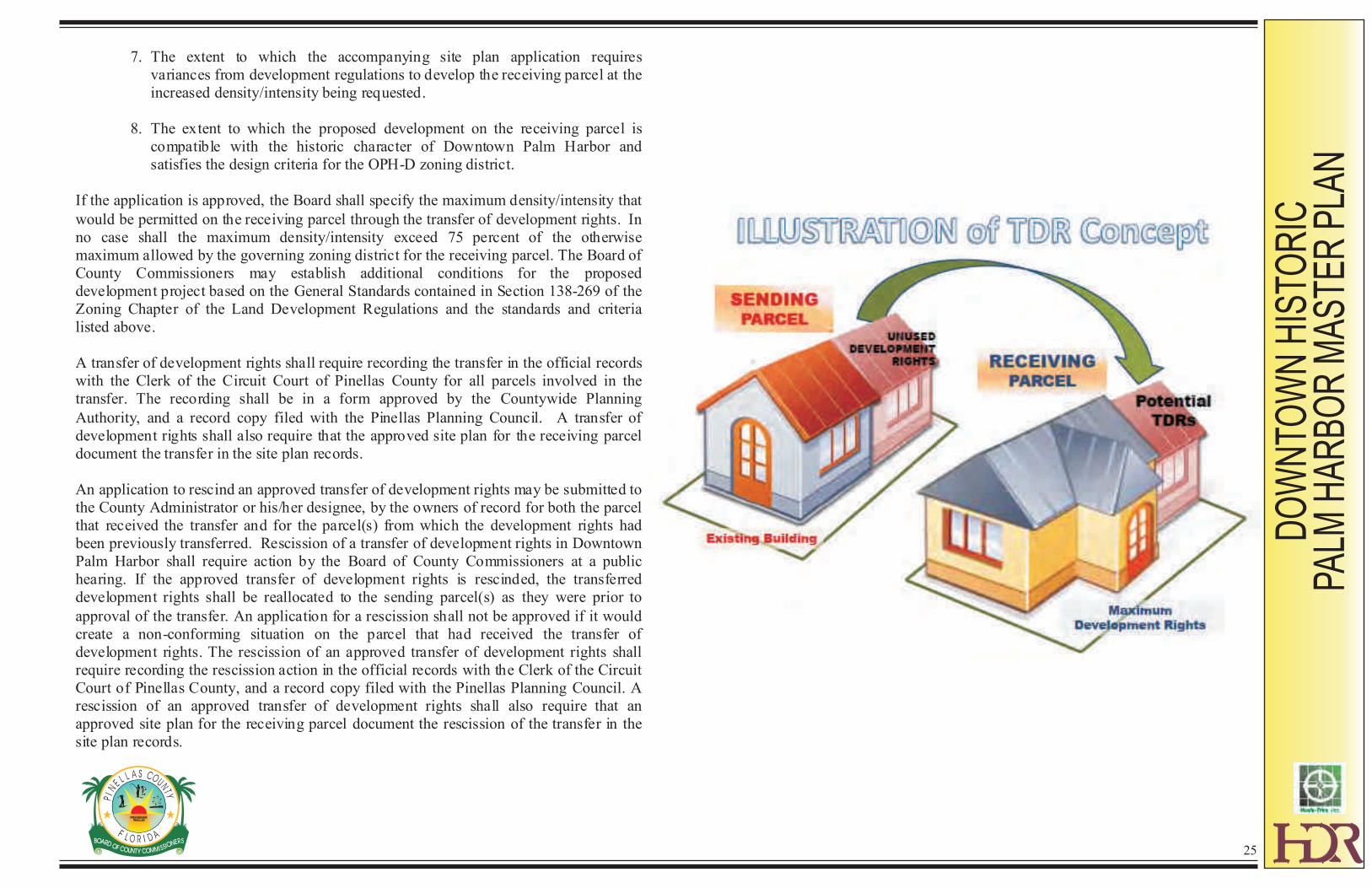
Transferable Development Rights (TDR) in Downtown Palm Harbor
On May 21, 2002, the Board of County Commissioners established a revitalization code for Downtown Palm Harbor through adoption of the Old Palm Harbor-Downtown Zoning District (OPH-D). This new zoning district is comprised of two sub-districts; the East Sub-District consists of parcels located east of Alternate U.S. Highway 19, and the West Sub-District includes parcels situated west of Alternate U.S. Highway 19.
Development rights of property in Downtown Palm Harbor located within the East Sub-District of the Old Palm Harbor-Downtown (OPH-D) Zoning District may be transferred to another property (receiving parcel) within the East Sub-District of the OPH-D Zoning District. Both residential density and floor area ratio may be transferred using the
mechanism established under this section of the Downtown Historic Palm Harbor Master Plan. These provisions for permitting the transfer of development rights do not restrict application of the mandatory rules on density/intensity averaging contained in the Pinellas County Comprehensive Plan within Downtown Palm Harbor. Any parcel from which development rights are transferred will be limited to the use and density/intensity that remains after the transfer. In particular:
1. The residual development rights on the sending parcel will be limited to the remnant use and density/intensity available under the parcel’s zoning designation and not transferred.
2. After development rights have been transferred, the residual development rights on the sending parcel must equal or exceed 50 percent of the maximum density/intensity available under the parcel’s zoning designation.
3. Determination of the available remnant use and density/intensity on the sending parcel shall be consistent with the Pinellas County Comprehensive Plan and the governing zoning district.
4. The transfer of development rights shall not result in any combination of use or density/intensity above that which is otherwise permitted under the zoning districts for the sending and receiving parcels, when taken together.
An application to transfer development rights shall be accompanied by:
1. A site plan application for the receiving parcel. The site plan application shall include all parcels that comprise the proposed development project, including any parcel(s) required to satisfy the on-site parking requirements.
2. An application for a Certificate of Appropriateness (COA) for the receiving parcel
in accordance with the Pinellas County Land Development Code, or an approved COA for the receiving parcel if one has already been issued.
An application to transfer development rights in Downtown Palm Harbor shall be considered by the Board of County Commissioners through the conditional use hearing process. A proposed development project that requires the use of transferable development rights may be permitted by the Board of County Commissioners as a conditional use within the East Sub-District of the OPH-D Zoning District. In addition to general standards (2) through (7) in Section 138-269 of the Zoning Chapter of the Land Development Code, the following standards and criteria shall be considered when making a decision on an application to transfer development rights:
1. Development rights may only be transferred to a receiving parcel that are consistent with the use characteristics of the zoning district for the receiving parcel;
2. Only one application for a transfer of development rights may be approved for a receiving parcel. The development rights transferred to the receiving parcel through that one application may come from one or more sending
parcels.
3. Post transfer of development rights in the receiving area will result in development that is compatible with the Downtown Historic Palm Harbor Master Plan and with existing and planned land uses on adjacent properties;
4. The receiving parcel’s site plan shall be consistent with the applicable land development regulations, including but not limited to, height and parking requirements.
5. The sending parcel(s) shall be in compliance with all property maintenance standards specified in the Pinellas County Land Development Code for Downtown Palm Harbor.
6. The extent to which the accompanying site plan application supports the goal, objectives and policies of the Economic Element of the Pinellas County Comprehensive Plan, including the number and types of jobs that would be located on the receiving parcel.
DO
WN
TOW
N H
ISTO
RIC
PA
LM H
AR
BO
R M
AS
TER
PLA
N
24
7. The extent to which the accompanying site plan application requires
variances from development regulations to develop the receiving parcel at the increased density/intensity being requested.
8. The extent to which the proposed development on the receiving parcel is
compatible with the historic character of Downtown Palm Harbor and satisfies the design criteria for the OPH-D zoning district.
If the application is approved, the Board shall specify the maximum density/intensity that
would be permitted on the receiving parcel through the transfer of development rights. In no case shall the maximum density/intensity exceed 75 percent of the otherwise maximum allowed by the governing zoning district for the receiving parcel. The Board of County Commissioners may establish additional conditions for the proposed development project based on the General Standards contained in Section 138-269 of the Zoning Chapter of the Land Development Regulations and the standards and criteria listed above. A transfer of development rights shall require recording the transfer in the official records with the Clerk of the Circuit Court of Pinellas County for all parcels involved in the transfer. The recording shall be in a form approved by the Countywide Planning
Authority, and a record copy filed with the Pinellas Planning Council. A transfer of development rights shall also require that the approved site plan for the receiving parcel document the transfer in the site plan records. An application to rescind an approved transfer of development rights may be submitted to the County Administrator or his/her designee, by the owners of record for both the parcel that received the transfer and for the parcel(s) from which the development rights had been previously transferred. Rescission of a transfer of development rights in Downtown Palm Harbor shall require action by the Board of County Commissioners at a public hearing. If the approved transfer of development rights is rescinded, the transferred development rights shall be reallocated to the sending parcel(s) as they were prior to
approval of the transfer. An application for a rescission shall not be approved if it would create a non-conforming situation on the parcel that had received the transfer of development rights. The rescission of an approved transfer of development rights shall require recording the rescission action in the official records with the Clerk of the Circuit Court of Pinellas County, and a record copy filed with the Pinellas Planning Council. A rescission of an approved transfer of development rights shall also require that an approved site plan for the receiving parcel document the rescission of the transfer in the site plan records.
DO
WN
TOW
N H
ISTO
RIC
PA
LM H
AR
BO
R M
AS
TER
PLA
N
25
IMPLEMENTATION
DO
WN
TOW
N H
ISTO
RIC
PA
LM H
AR
BO
R M
AS
TER
PLA
N
26
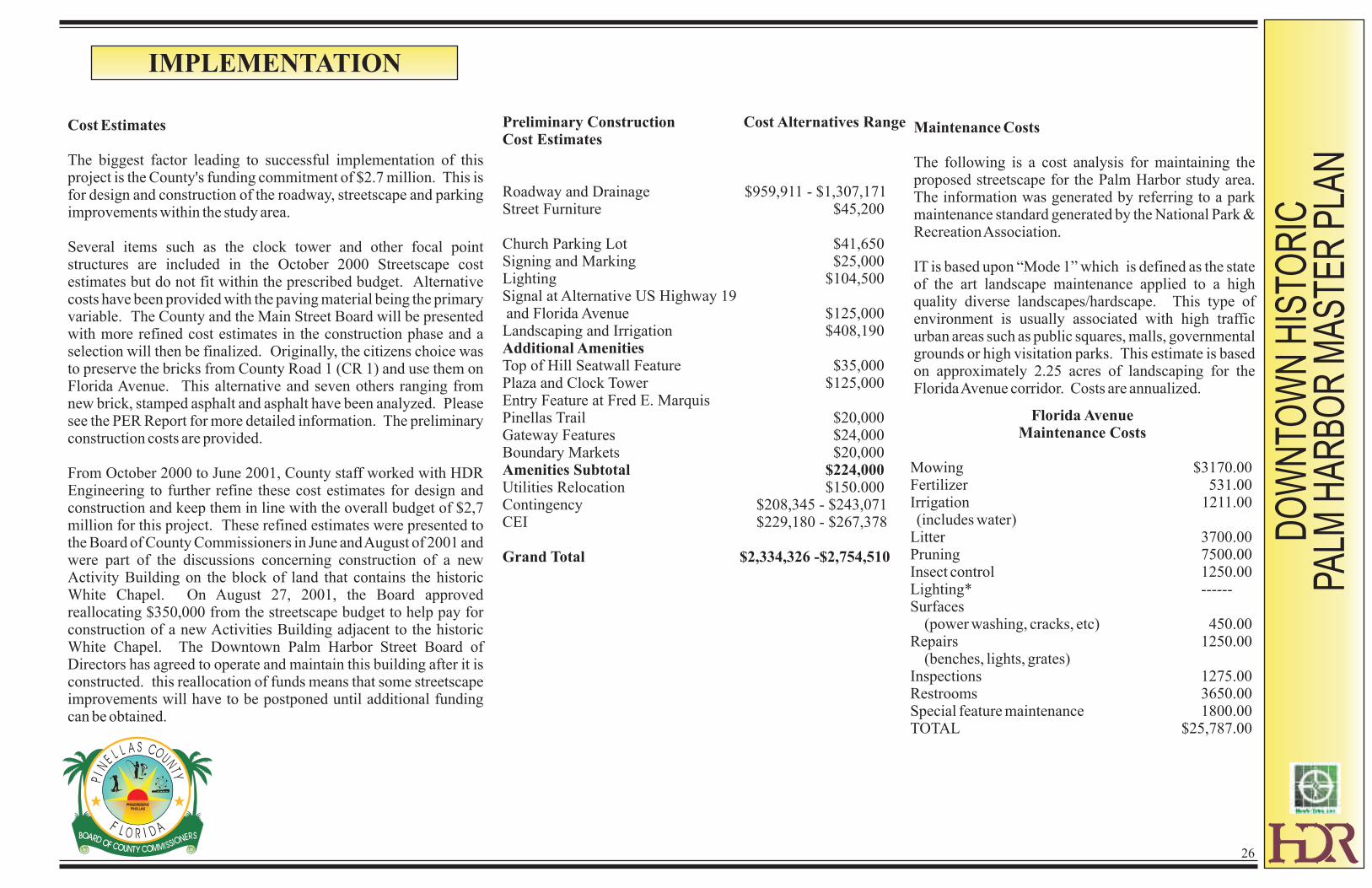
Cost Estimates
The biggest factor leading to successful implementation of this project is the County's funding commitment of $2.7 million. This is for design and construction of the roadway, streetscape and parking improvements within the study area.
Several items such as the clock tower and other focal point structures are included in the October 2000 Streetscape cost estimates but do not fit within the prescribed budget. Alternative costs have been provided with the paving material being the primary variable. The County and the Main Street Board will be presented with more refined cost estimates in the construction phase and a selection will then be finalized. Originally, the citizens choice was to preserve the bricks from County Road 1 (CR 1) and use them on Florida Avenue. This alternative and seven others ranging from new brick, stamped asphalt and asphalt have been analyzed. Please see the PER Report for more detailed information. The preliminary construction costs are provided.
From October 2000 to June 2001, County staff worked with HDR Engineering to further refine these cost estimates for design and construction and keep them in line with the overall budget of $2,7 million for this project. These refined estimates were presented to the Board of County Commissioners in June and August of 2001 and were part of the discussions concerning construction of a new Activity Building on the block of land that contains the historic White Chapel. On August 27, 2001, the Board approved reallocating $350,000 from the streetscape budget to help pay for construction of a new Activities Building adjacent to the historic White Chapel. The Downtown Palm Harbor Street Board of Directors has agreed to operate and maintain this building after it is constructed. this reallocation of funds means that some streetscape improvements will have to be postponed until additional funding can be obtained.
Maintenance Costs
The following is a cost analysis for maintaining the proposed streetscape for the Palm Harbor study area. The information was generated by referring to a park maintenance standard generated by the National Park & Recreation Association.
IT is based upon “Mode 1” which is defined as the state of the art landscape maintenance applied to a high quality diverse landscapes/hardscape. This type of environment is usually associated with high traffic urban areas such as public squares, malls, governmental grounds or high visitation parks. This estimate is based on approximately 2.25 acres of landscaping for the Florida Avenue corridor. Costs are annualized.
Florida AvenueMaintenance Costs
Mowing $3170.00Fertilizer 531.00Irrigation 1211.00 (includes water)Litter 3700.00Pruning 7500.00Insect control 1250.00Lighting* ------Surfaces (power washing, cracks, etc) 450.00Repairs 1250.00 (benches, lights, grates)Inspections 1275.00Restrooms 3650.00Special feature maintenance 1800.00TOTAL $25,787.00
Preliminary Construction Cost Alternatives RangeCost Estimates
Roadway and Drainage $959,911 - $1,307,171Street Furniture $45,200
Church Parking Lot $41,650Signing and Marking $25,000Lighting $104,500Signal at Alternative US Highway 19 and Florida Avenue $125,000Landscaping and Irrigation $408,190Additional AmenitiesTop of Hill Seatwall Feature $35,000Plaza and Clock Tower $125,000Entry Feature at Fred E. Marquis Pinellas Trail $20,000Gateway Features $24,000Boundary Markets $20,000Amenities Subtotal $224,000Utilities Relocation $150.000Contingency $208,345 - $243,071CEI $229,180 - $267,378
Grand Total $2,334,326 -$2,754,510
DO
WN
TOW
N H
ISTO
RIC
PA
LM H
AR
BO
R M
AS
TER
PLA
N
27
Regulatory Changes
As previously mentioned, two regulatory changes are proposed to be adopted by the Board of County Commissioners (BOCC) to ensure these urban, historic designs and concepts can continue to be implemented. The Pinellas County Comprehensive Plan must be amended to add a new Future Land Use category and the Future Land Use Map must be amended to identify the area with the new category. This is a process controlled by Florida Statues and is anticipated to be enacted by the Summer of 2002. A draft has been prepared by the Pinellas County Planning Department. The Countywide Future Land Use Mao must also be amended for the Downtown area.
The Revitalization Code anticipated to be adopted by early 2002, but can become effective only after the plan amendment is fully approved by the BOCC and the State Department of Community Affairs. Once the new Code is adopted, the Zoning Atlas must be amended to designate Downtown Palm Harbor with the new Zoning District.
Schedule
Detailed design and construction plans are anticipated to begin in early 2002. Construction of CR 1 will begin in early 2002 and will occur in two phases to be completed in spring 2004. The construction of the Palm Harbor streetscape and roadway improvements are planned for October 2003 through October 2004.
This will allow the major stormwater system to be near completed prior to initiation of the Palm Harbor project. It will also minimize the impact on merchants by being sensitive and trying to work around their busy season. Due to the 9-12 month length of the construction project, a maintenance of traffic plan will be prepared and coordinated with the Main Street Association and staff in order to minimize the impacts of construction on the businesses and resident of downtown.
Maintenance Responsibilities
Roads, Sidewalks, and Proposed Traffic Signal at Florida Avenue and Alternate US Highway 19:
Will be maintained by Pinellas County. Annual costs are estimated at $3,900 for the Traffic Signal and $7,800 for the roads and sidewalks.
Streetlights (monthly electric bills and maintenance of lights and poles) and Event Electrical Receptacles:
A Streetlighting District will need to be established and FPC will design, install and maintain the decorative streetlights. The community will be responsible for the maintenance of the event electrical receptacles.
Landscaping and Irrigation System:
Will be maintained by the community. Costs estimated by HDR at approximately $26,000 per year. If costs associated with maintaining public restrooms are not included the annual cost is estimated at roughly $22,000.
Public Parking Lot:
Annual maintenance costs are estimated at $2,000 if the lot is heavily used. After five years, $5,000 will be needed to repave and restripe the lot.
Options for this responsibility include Heritage Village, Public Works, the community, and/or the Old Palm Harbor Main Street organization.

APPENDIX A
DO
WN
TOW
N H
ISTO
RIC
PA
LM H
AR
BO
R M
AS
TER
PLA
N
OLD PALM HARBOR VISION STATEMENT
28
VISION STATEMENT FOR OLD PALM HARBOR Old Palm Harbor is located about halfway between Dunedin and Tarpon Springs. It extends eastward from Sutherland Bayou to encompass the general area originally known as Sutherland. Planned in the last 19th Century before the advent of the automobile, Old Palm Harbor retains important elements of its original town design and its history as a college town and rural center with strong ties to the citrus industry. Although located in a highly urbanized county, Old Palm Harbor is known for its small town atmosphere and a strong sense of community. It is agreed that the community heritage and those characteristics that make Old Palm Harbor a special place are worthy of protection and the following COMMUNITY VISION is established for the future of Old Palm Harbor. COMMUNITY CHARACTER: The small town atmosphere of Old Palm Harbor shall be
preserved and enhanced as an important distinguishing characteristic of the community.
Objective: Changes in Old Palm Harbor shall be compatible with and support this small town atmosphere, which is characterized by such community features as the following: - a safe walkable community with ample sidewalks - streets safe for bicyclists - a mix of commercial and residential uses - a diverse housing stock of various styles, sizes and values - low density development - abundance of trees and tree-lied streets - limited traffic at slow speeds through the neighborhood The hills of Old Palm Harbor shall be emphasized as a unique feature in a portion of the state where flat landscape is more characteristic.
COMMUNITY HERITAGE: Old Palm Harbor contains important remnants of its history as
one of the oldest communities in Pinellas County. These historic features include several
residential and commercial structures, the original street layout and wide boulevards, access to
Sutherland Bayou, a unique vista of the Gulf of Mexico from Florida Avenue, as well as numerous
artifacts that have been saved over the years. These historic features will be preserved, enhanced
and restored whenever possible because of their value in understanding the community’s origins,
and their contribution to the quality of life.
Objectives:
Objectives: The use of historic features characteristic of Old Palm Harbor, such as porches, shall be encouraged to enhance the community’s historic identity. The Downtown Palm Harbor Historic District contains the community’s historic commercial center and will be clearly identifiable, vibrant focal point for Old Palm Harbor, with people-oriented activities throughout the day and evening. The close relationship between the community and the waterfront will be reestablished and emphasized. This will include improved visual and physical access.
SENSE OF COMMUNITY: Old Palm Harbor’s sense of community has been fostered
over the years by opportunities for neighbors to get to know one another and by the
location of educational, religious, and social institutions in the community. To strength
this sense of community, Old Palm Harbor will continue to provide places and
opportunities for the neighborhood to come together and build relationships, and that
help establish the community’s identity.
Objectives: Efforts will be supported to improve access to recreational facilities such as the Fred Marquis Pinellas Trail, Pop Stansell Park, and the recreational fields west of Alternate US Highway 19. The community’s annual festivals will be supported. Festivals should highlight the unique character of the area. Efforts to expand the variety of activities and programming for youth and children in the community will be encouraged. Beneficial partnerships will be established with the elementary school, the University High School, the Senior Center and other community facilities to further integrate them into the life of the community. Emphasize existing, or established new, community landmarks that identify the location of Old Palm Harbor and portray its unique community characteristics and heritage.
DO
WN
TOW
N H
ISTO
RIC
PA
LM H
AR
BO
R M
AS
TER
PLA
N
29

LOCAL BUSINESSES: The businesses in Old Palm Harbor offer a mixture of
retail, service and professional offices. Vacant and underutilized land creates the
opportunity for additional growth and expansion of the commercial sector in Old
Palm Harbor which should serve both the local community as well as attracting
visitors.
Objectives: Development should be compatible with maintaining the overall bucolic and small town character of the area, in both appearance and function, while enhancing the local economy. Commercial activity along the Alternate US Highway 19 corridor should be encouraged to reflect the positive attributes of the area. A mix of commercial activities will be achieved to assure the vitality of the area. Old Palm Harbor and the Historic District will become a focal point for business activity that is readily and clearly recognized by the local community and visitors. Businesses in Old Palm Harbor and the Historic District will be readily accessible to people using all modes of transportation.
DO
WN
TOW
N H
ISTO
RIC
PA
LM H
AR
BO
R M
AS
TER
PLA
N
30

DO
WN
TO
WN
HIS
TO
RIC
PA
LM H
AR
BO
R M
ASTER
PLA
N
31
APPENDIX B