Particle Physics Physics 735: Fall 2008 Sridhara Dasu dasu/physics735.

PAKISTAN
WATER AND POWER DEVELOPMENT AUTHORITY
(WAPDA)
Dasu Hydropower Project
ENVIRONMENTAL AND SOCIAL ASSESSMENT
EXECUTIVE SUMMARY
Report by Independent Environment and Social
Consultants
March 2014
Pub
lic D
iscl
osur
e A
utho
rized
Pub
lic D
iscl
osur
e A
utho
rized
Pub
lic D
iscl
osur
e A
utho
rized
Pub
lic D
iscl
osur
e A
utho
rized
Pub
lic D
iscl
osur
e A
utho
rized
Pub
lic D
iscl
osur
e A
utho
rized
Pub
lic D
iscl
osur
e A
utho
rized
Pub
lic D
iscl
osur
e A
utho
rized

ii Dasu Hydropower Project
Contents
List of Acronyms ........................................................................................................................ iv
1. Introduction........................................................................................................................... 1
1.1. Background .................................................................................................................... 1
1.2. The Proposed Project ..................................................................................................... 1
1.3. The Environmental and Social Assessment ................................................................... 3
1.4. Composition of Study Team .......................................................................................... 3
2. Policy, Legal and Administrative Framework ................................................................... 4
2.1. Applicable Legislation and Policies in Pakistan ............................................................ 4
2.2. Environmental Procedures ............................................................................................. 6
2.3. World Bank Safeguard Policies ..................................................................................... 6
2.4. Compliance Status with Pakistani Legislation and World Bank Policies ..................... 7
3. Project Description ............................................................................................................... 8
3.1. Background .................................................................................................................... 8
3.2. Project Objective ........................................................................................................... 9
3.3. Location of the project ................................................................................................... 9
3.4. Project Components ..................................................................................................... 11
3.5. Phasing ......................................................................................................................... 12
3.6. Project Cost .................................................................................................................. 13
4. Project Alternatives ............................................................................................................ 13
4.1. Alternatives to the Project ........................................................................................... 13
4.2. Site selection of main structure and hydraulic and electrical infrastructure ................ 14
4.3. Alternatives for the type of structure ........................................................................... 14
4.4. Alternatives for the lay-out of intake and tail race tunnels .......................................... 15
4.5. Alternative sources of construction material ............................................................... 15
4.6. Alternatives for the selection of generating equipment ............................................... 15
4.7. Alternative construction schedules .............................................................................. 16
4.8. Alternatives for resettlement ........................................................................................ 16
5. Description of Environment............................................................................................... 16
5.1. Physical Environment .................................................................................................. 16
5.2. Biological Environment ............................................................................................... 18
5.3. Social and Economic Environment ............................................................................. 20
5.4. Social and Cultural Aspects ......................................................................................... 22
5.5. Physical Cultural Resources ........................................................................................ 23
6. Other Relevant Issues ......................................................................................................... 24
6.1. Risk of earthquakes ...................................................................................................... 24
6.2. Risk of landslides ......................................................................................................... 24
6.3. Risk of flooding ........................................................................................................... 24
6.4. Climate change ............................................................................................................ 24
6.5. Greenhouse Gasses Emissions ..................................................................................... 25
7. Potential Impacts and their Mitigations ........................................................................... 26
7.1. General ......................................................................................................................... 26

iii Dasu Hydropower Project
7.2. Impact Assessment Methodology ................................................................................ 26
7.3. Summary of Assessed Impacts .................................................................................... 26
7.4. Environmental Impacts due to Project Siting ............................................................. 31
7.5. Social Impacts during Pre-construction Stage ............................................................. 34
7.6. Environmental Impacts during Construction Stage ..................................................... 35
7.7. Social Impacts during Construction Stage ................................................................... 38
7.8. Environmental Impacts during Operation and Maintenance ....................................... 38
7.9. Social Issues during Operation and Maintenance Stage .............................................. 42
8. Cumulative Impact Assessment framework .................................................................... 44
8.1. Background .................................................................................................................. 44
8.2. Context of DHP ........................................................................................................... 44
8.3. Expected developments in the Upper Indus Basin ...................................................... 46
8.4. Cumulative impacts and trends to be expected ............................................................ 47
8.5. Mitigations to be implemented under DHP ................................................................. 52
8.6. Summary of major cumulative environmental and social concerns and
mitigations ................................................................................................................... 53
9. Environmental and Social Management Plan .................................................................. 56
9.1. General ......................................................................................................................... 56
9.2. Environmental and Social Management ...................................................................... 56
9.2.1. Environmental Codes of Practice ........................................................................... 56
9.2.2. Site-specific Plans .................................................................................................. 56
9.2.3. Social Management ................................................................................................ 58
9.3. Overview of Impacts and Mitigating Measures ........................................................... 59
9.4. Monitoring Plan ........................................................................................................... 66
9.5. Institutional Aspects .................................................................................................... 68
9.6. Capacity Building and Training ................................................................................... 69
9.7. Panel of Experts ........................................................................................................... 69
9.8. Audits ........................................................................................................................... 69
9.9. Reporting and Grievances ............................................................................................ 69
9.10. Cost of EMP and SRMP .............................................................................................. 70
10. Stakeholder Consultations and Disclosure ....................................................................... 71
10.1. Overview ...................................................................................................................... 71
10.2. Community Consultations ........................................................................................... 71
10.3. Consultation Workshops .............................................................................................. 72
10.4. Disclosure .................................................................................................................... 75

iv Dasu Hydropower Project
List of Tables and Figures
Table 1: Compliance of Project with GoP Legislation and WB Safeguard Policies ......................... 7
Table 2: Staged development of DHP in relation to Basha ............................................................. 13
Table 3: Overall Estimate of Project Cost (Million Dollars) ........................................................... 13
Table 4: Comparison of GHG emissions from DHP and thermal alternatives ................................ 25
Table 5: Significance of impact criteria ........................................................................................... 26
Table 6: Potential Impacts and their Significance ........................................................................... 27
Table 7: HP projects in the Upper Indus Basin (WAPDA Vision 2025) ......................................... 46
Table 8: Percent of Change in River Hydrology (Flow Volume) Downstream of
Tarbela under Different Hydropower and Storage Scenarios ............................................ 47
Table 9: Impact in percentages of water availability and ecological releases downstream
Kotri under different hydropower/storage scenarios ......................................................... 48
Table 10: Social and cultural impacts of DHP and BD ..................................................................... 51
Table 11: Summary of major environmental and social concerns regarding cumulative impacts .... 54
Table 12: Overview of Impacts and Mitigation ................................................................................. 60
Table 13: Effects Monitoring Plan ..................................................................................................... 66
Table 14: EMP Implementation Cost Estimates ................................................................................ 70
Table 15: Cost of implementing RAP ................................................................................................ 70
Table 16: Number of persons covered in various Consultation Meetings ......................................... 71
Table 17: Key issues raised in community consultations .................................................................. 71
Table 18: Summary of Discussions in Consultation Workshops....................................................... 72
Figure 1: Location of DHP in Pakistan ............................................................................................... 2
Figure 2: Layout of Dasu Hydropower Project ................................................................................. 10
Figure 3: Seasonal migration of population between various elevations .......................................... 22
Figure 4: Reservoir Area ................................................................................................................... 32
Figure 5: River Profile and Water Levels on the Downstream of the Dam site ............................... 40
List of Acronyms
AP Affected persons
asl Above (mean) sea level
BCM billion cubic meters
CIIA Cumulative and Induced Impact
Assessment
CITES Convention on International Trade in
Endangered Species
CSC Construction Supervision Consultants
DB Diamer Basha Hydropower project
DCO District Coordinating Officer
DHC Dasu Hydropower Consultants
DHP Dasu Hydropower Project
DRA District Revenue Officer
EARF Environmental Assessment and
Review Framework
EIA Environmental Impact
Assessment
ECP Environmental Code of Practices
EHS Environment, Health, and Safety

iii Dasu Hydropower Project
EMAP Environmental Management Action
Plan
EMP Environmental Management Plan
EPA Environmental Protection Agency
ESA Environmental and Social
Assessment
ESMP Environmental and Social
Management Plan
ESMU Environment and Social Management
Unit
ESS Environment and Social Supervisor
FGD focus group discussions
FSL Full supply level
GAP Gender Action Plan
GLOF glacial lake outburst flood
GoP Government of Pakistan
ha hectare
HIV/AIDS Human immunodeficiency virus/
acquired immunodeficiency
syndrome
HSE Health, Environment and Safety
ICOLD International Commission on Large
Dams
IEE Initial Environmental
Examination
IFC International Finance Corporation
ILRP Income and livelihood restoration
program
IPCC International Panel on Climate
Change
KKH Karakorum Highway
KP Khyber Pakhtunkhwa
LA Land acquisition
LLO Low Level Outlet
M&E Monitoring and Evaluation
MoE Ministry of Environment
MoWP Ministry of Water and Power
NCS National Conservation Strategy
NEAP National Environmental Action Plan
NEP National Environmental Policy
NEQS National Environmental Quality
Standards
NGO Non Governmental Organization
NOC No Objection Certificate
NTDC National Transmission and Dispatch
Company
OP Operational Policy
O&M Operation and maintenance
Pak-EPA Pakistan Environmental Protection
Agency
PATA Provincially Administrated Tribal
Areas
PEPA Pakistan Environmental Protection
Act
PKR Pak Rupees
PMU Project Management Unit
PRA Participatory rural appraisal
R&D Research and development
RAP Resettlement Action Plan
RCC Roller compacted concrete
SAP Social Action Plan
SRMP Social and Resettlement Management
Plan
WAPDA Water and Power Development
Authority
WB World Bank
WBG World Bank Group
WCAP Water Sector Capacity Building and
Advisory Services Project
WEC WAPDA Environmental Cell

1 Dasu Hydropower Project
1. Introduction The Dasu Hydropower Project (DHP) is a major investment project proposed by the Government of Pakistan
(GoP) to modernize and expand the energy sector of the country, while shifting from thermal generated
electricity to low cost and high reward, clean generation of hydropower. The project is situated in remote
mountainous terrain in the Upper Indus valley in the district of Kohistan, Khyber Pakhtunkhwa (KP) province
in the north of Pakistan. The DHP has three major components: a) the main dam, powerhouse and its
ancillaries, residential complex, and allied facilities; b) realignment of about 65 km long stretch of the
Karakoram Highway (KKH); and c) transmission line (TL) for power evacuation from the powerhouse. Since
the detailed designs for (a) and (b) above have been completed a comprehensive Environmental and Social
Assessment (ESA) has been carried out and presented through the main ESA report. For the transmission line,
the planning and design of the alignment and towers have not been finalized yet. Therefore for (c) above only
an Environmental Assessment and Review Framework (EARF) has been prepared which provides guidance
on the subsequent detailed ESA, which will commensurate with the preparation of detailed design of the
Transmission Line. EARF is also presented as a stand-alone document. This Executive Summary report
describes the potential environmental and social impacts of the DHP project. The environmental and social
assessment is an important tool for decision making. In the ESA the potential environmental and social
impacts of the project and their possible mitigations are described and worked out into environmental and
social management plans; in addition, appropriate measures are also identified to enhance the environmental
and social benefits of the project.
1.1. Background
The energy sector in Pakistan: Pakistan is suffering from an acute power and energy crisis which is
primarily caused by an increasing gap between insufficient energy supply and an increasing demand for
power. The demand for power in the country is still relatively low as compared with the industrialized world.
However, in recent years the use of electricity is increasing with an estimated 7.6 percent per year, measured
over the period 2001-2011. The supply has increased in the same period with only 3.5 percent per year,
resulting in a shortfall of over 7,700 MW in 2011. Without an extra acceleration in the production of energy
the gap between demand and supply is expected to increase to over 17,000 MW in the year 2029.
The Vision 2025 Program of WAPDA: In order to increase the hydropower generation capacity in the
country, and meanwhile maintaining the water supply to the Indus irrigation system the Water and Power
Development Authority (WAPDA) has prepared its “Vision 2025” program. The proposed DHP is an integral
part of WAPDA’s “Vision 2025” and the Power Policy 2013 of GOP. The objectives of the Power Policy
2013 is to improve electric power generation capacity, the revival of the country’s economy by injecting
cheap hydropower energy, and meet the future needs of Indus Basin irrigation system. The DHP is one of the
priority projects in the Program. A feasibility study for this project was carried out in 2009 to identify the
location of the project and to prepare preliminary engineering designs, cost estimates and a preliminary EIA.
The detailed design has been prepared by an international consortium of consultants: the Dasu Hydropower
Consultants (DHC). Financial assistance for study and design is given by World Bank under their Water
Sector Capacity Building and Advisory Services Project (WCAP).
1.2. The Proposed Project
Location: The Dasu Hydropower Project is located on the Indus River at a site about 8 km upstream of Dasu
Bridge near the small town of Dasu, the capital of Kohistan district in KP province (see Figure 1). At this site
the river Indus flows in a deep and narrow valley (elevation 750 - 800 m asl) which is strongly incised into the
lower Himalayan mountains with an average altitude of 2,000 to 4,000 m. The project area is accessible
through the Karakorum Highway (KKH), which is the only road connection between Islamabad (at 350 km
distance) and the north of Pakistan and China (Kashgar). About 74 km further upstream along the Indus
another structure under the “Vision 2025” program is planned: the Diamer-Basha Dam.
Main structure and powerhouse: The DHP includes the construction of a 242 m high concrete dam in a
gorge like valley of the Upper Indus River. Behind the main structure there will be a 73 km long reservoir (at
full supply level of 950 m asl) with an average width of 365 m and a total surface of about 24 km². The DHP
also includes an underground powerhouse, housing 12 turbines, each producing 360 MW of power. The total
maximum generation capacity will be 4,320 MW. After full completion, the DHP is estimated to generate
about 21,500 GWh of energy per annum. This would significantly alleviate the shortage of electricity in the
country.

2 Dasu Hydropower Project
Figure 1: Location of DHP in Pakistan

3 Dasu Hydropower Project
Karakorum Highway, access roads, and power supply: Apart from the hydraulic and electrical
infrastructure needed, the project includes the realignment of about 62 km of KKH at a higher level (above
reservoir level) due to submergence of the current road, including the construction of eight new bridges. Also
about 12 km of an access road from Komila town to dam site is foreseen, together with some 23 km of new
access roads along the right bank, about 18 km of minor roads and tracks, and one suspension bridge crossing
the Indus at Kandia. Also included in the project is the construction of a 132 kV transmission line between
Dasu and Dubair grid station, located at some 45 km downstream of the project site. The line will provide the
project and the residential colony with electricity during the years of construction and is included in the
present ESA.
Transmission lines: Two 250 km long 500 kV transmission lines will be built to connect the Dasu plant with
the main power distribution network at Pathar Garh near Hassanabdal (District Attock). The construction of
the long distance transmission lines is a part of the project to be implemented by the National Transmission
and Dispatch Company (NTDC). An Environmental Assessment and Review Framework (EARF) for this
component has been prepared. The EARF included a socio-economic survey and an impact screening in the
area; and description of consultations held with the communities. The detailed Environmental and Social
Impact Assessment will be carried out in 2014- 2015, in accordance with the Bank’s safeguard policies.
Phasing of the project: The project will be implemented in two stages. Stage 1 (2015-2022) will include the
construction of the main hydraulic structures and the installation of six of the planned twelve turbines. Stage 2
which includes the installation of the six remaining turbines will start after construction of the Diamer Basha
project and will be completed in four years.
1.3. The Environmental and Social Assessment
Studies and basic data: The Environmental and Social Assessment (ESA) is based on field studies and data
collected between 2011 and 2013 by the Dasu Hydropower Consultants (DHC) team charged with the design
of the project. A team of independent consultants was also hired in parallel by WAPDA, to provide input into
the baseline and impact assessment work of the design team, as well as to supplement their analysis as needed
in order to assemble the present ESA report in line with World Bank standards. During their review of the
environmental and social reports (May 2012 – November 2013) the independent consultants developed a
common approach with DHC in estimating and interpreting the potential impacts of the project and their
possible mitigations. The continuous feed-back proved to be very useful. The role and scope of work of the
independent consultants is described further in section 1.4 below.
Contents of the present document: After a description of the Pakistani legal and administrative framework
and the applicable World Bank policies (chapter 2) a project description is presented in chapter 3, followed
by a discussion of project alternatives considered (chapter 4). A description of the physical, biological and
socio-economic environment is given in chapter 5. In chapter 6 several relevant issues such as risks of
earthquakes, landslides and flooding are discussed, including the effects of climate change. Potential adverse
effects of the DHP are described in chapter 7 of the ESA report. Potential cumulative impacts and concerns
associated with other hydropower developments in the Upper Indus Basin (UIB) are presented in chapter 8.
Possible mitigating measures to offset, reduce or compensate potential negative impacts of the project are
included in the Environmental and Social Management Plan (ESMP) summarized in chapter 9, but presented
in more detail in the accompanying ESA and SRMP volumes. This chapter includes also a description of the
institutional aspects and responsibilities in the project. Finally, in chapter 10 an overview is given of all
stakeholder consultations and activities for disclosure and access to information.
1.4. Composition of Study Team
Independent consultants: WAPDA engaged a team of independent consultants - Mr. Reitse Koopmans, Mr.
Mohammad Omar Khalid and Mr. Hans van Zon – to assess the environmental as well as social impacts of the
project, to prepare the environmental and social management plan, and to prepare the main ESA report as well
as this Summary ESA report. The independent consultants commenced working shortly after the start of the
project design (August 2011) and they were authorized to recruit/access professional expertise as required for
carrying out the independent ESA. During the ESA process, the independent consultants regularly interacted
with the DHC’s design team providing technical advice and recommendations, carried out their own field
visits, participated in the consultations, and conducted their independent analysis and impact assessment.
Social study team (DHC): The national members of the social and resettlement team included Maqsood
Ahmed, Dr. Ramzan Chaudhary, Awais Hassan Khan (Resettlement Specialists), Anwar Fazal Ahmed, Arslan
Tariq (Sociologist), Saima Raoof and Ujala Saleem (Gender Specialists), Rana Muhammad Saleem

4 Dasu Hydropower Project
(Consultation Specialist), Ahmed Saleem (Communications Specialist), Noorul Hadi (Livelihood Specialist),
and Dr. Ilyas Quershi (Public Health Specialist). The international experts included Dr Mohammad Zaman,
Sunil Gonnetilleke and Dr. Haimin Wang (Resettlement Specialists), Dr. Iffat Idris (Social/Conflict Analyst),
and Dr. Bernhard Eder (Public Health Specialist).
Environmental study team (DHC): The national environmental team members included Zafar Iqbal
Chaudry and Mudassar Hassan (Environment specialists), Dr. William George and Prof. Tahir Omer (Fish
experts), Dr. Sajid Nadeem (Wildlife expert), Dr. Rehmatulla Qureshi (Vegetation expert), Prof. Ihsan H.
Nadiem, Irshad Ahmad Soomro (PCR specialists), Dr. Allah Bakhsh Sufi (CIIA specialist) and Noman Saeed
(GIS specialist). The international team members included Dr. Venkata Nukala (Lead Environmental
specialist), Malcolm Winsby (Aquatic Ecologist), Dr. Kashif Sheikh (Terrestrial Ecologist) and Dr. Masud
Karim (Environmental specialist- Climate Change).
International Panel of Experts: WAPDA has also engaged an international panel of experts (IPOE)
consisting of renowned specialists including Mr. Erik Helland-Hansen from Norway (Environmental expert)
and Prof Shi Guoqing from China (Social expert). These experts together with experts from various other
disciplines have reviewed the design of the project including the environmental and social aspects. These
experts have participated in three missions to Pakistan and had discussions with design consultants and
WAPDA, paid site visits, reviewed the ESA reports and provided their respective comments, which have been
addressed while preparing the present reports.
2. Policy, Legal and Administrative Framework
2.1. Applicable Legislation and Policies in Pakistan
Pakistan Environmental Protection Act, 1997: The Act establishes the general conditions, prohibitions, and
enforcement for the prevention and control of pollution and the promotion of sustainable development in the
Country. It also describes and delineates the powers and functions of the Pakistan Environmental Protection
Council, Pakistan Environmental Protection Agency (Pak-EPA), provincial Environmental Protection
Agencies (EPAs), and Environmental Tribunals. In particular, the Act creates the authority for delegation of
environmental management functions to the provincial EPAs. The requirement of conducting environmental
assessment before commencing developmental projects stems from this Act.
Other Relevant Legislation in Pakistan: Other legislation and regulations relevant to the proposed project
are listed below.
Pakistan Penal Code (1860), deals with offences against public interests e.g. to control noise, toxic
emissions and disposal of effluents;
Pakistan Explosives Act (1894) provides regulations for handling, transportation and use of explosives
used for quarrying and blasting of rock;
Land Acquisition Act, 1894;
Factories Act (1934), provides regulations for safe handling and disposal of toxic and hazardous materials
by contractors;
The North-west Frontier Province Wildlife (Protection, Preservation, Conservation And Management)
Act, 1975;
Protection of Trees Act (1949) prohibits cutting and logging of trees planted by the Forest Department
along roads and canals;
Pakistan Water and Power Development Authority Act (1958) authorizes WAPDA to develop water and
power resources in the country through construction and operation of water storages and powerhouses and
erecting electrical transmission lines;
Antiquity Act (1975) protects antiquities and empowers the Government of Pakistan (GoP) to prohibit
excavation and construction works in any area that may contain objects of archaeological or cultural
historic value;
Motor Vehicle Ordinance (1965) empowers licensing and other authorities to regulate traffic rules, speed
and weight limits and vehicle use;

5 Dasu Hydropower Project
KP Wildlife Protection, Preservation, Conservation and Management Act (1975) protects the province’s
wildlife resources directly and other natural resources indirectly. The act is particularly relevant for the
Kaigah private game reserve (5000 ha community managed);
Labor Laws: labor rights are provided in the Constitution of Pakistan; various acts and ordinances provide
additional rules for working hours, minimum working age and conditions of employment;
Highway Safety Ordinance (2000) includes provisions for licensing and registration of vehicles and
construction equipment;
Local Government Ordinance (2001) deals with enforcement of laws for land use, conservation of natural
vegetation, air, water, disposal of solid waste and wastewater effluents, public health and safety;
Project Implementation and Resettlement Ordinance (2001) safeguards the interests of persons/groups
having to be involuntarily resettled due to land acquisition caused by a proposed project. The proposed
Ordinance is supplementary to the Land Acquisition Act of 1894, as well as other Laws of Pakistan, and
included in the Draft Resettlement Policy.
Regulations and Guidelines: The regulations and guidelines relevant for the present ESA study are listed
below.
Pak-EPA IEE and EIA Regulations, 2000
National Environmental Quality Standards (NEQS), 2000, with updates in October 2010
Guidelines for the Preparation and Review of Environmental Reports, 1997
Guidelines for Public Consultations, 1997
Guidelines for Sensitive and Critical Areas, 1997
Policy and procedures for filing, review and approval of Environmental Assessments, 2000
Relevant National Policies and Plans: The national policies relevant to the proposed project and its
environmental and social assessment are briefly described below.
National Conservation Strategy (NCS), 1992, was adopted as the guiding environmental policy for
Pakistan. A Mid-Term Review was undertaken in 2000. The Mid-Term Review concluded that the
achievements under the Strategy had been primarily awareness raising and institution building, and that
future initiatives should emphasize improvements in implementation capacity.
The National Environmental Policy (NEP) was adopted in 2005 and provides broad guidelines to the
federal, provincial, and local governments in addressing environmental concerns and cross-sectoral issues
such as poverty, health, trade, and local governance. To achieve its policy objectives, the NEP directs the
Ministry of Environment (MoE), and provincial and local governments to develop plans for its
implementation.
The National Environmental Action Plan (NEAP) was adopted in 2001 with the stated objective of
alleviating poverty through environmental projects.
International Treaties signed by Pakistan: Pakistan is a signatory to a number of international environment-
related treaties, conventions, declarations and protocols. The following are the relevant international treaties
and conventions to which Pakistan is a party:
Convention on Biological Diversity, Rio de Janeiro, 1992.
United Nations Framework Convention on Climate Change, Rio de Janeiro, 1992.
Vienna Convention for the Protection of the Ozone Layer, Montreal, 1987.
Convention on Wetlands of International importance especially as Waterfowl Habitat, Ramsar, 1971 and
its amending protocol, Paris, 1982.
Convention on Conservation of Migratory Species of Wild Animals 1979.
Convention on International Trade in Endangered Species of Wild Fauna and Flora (CITES), Washington,
1973.
Convention concerning the Protection of World Culture and Natural Heritage (World Heritage
Convention), 1972.
International Plant Protection Convention, 1951.
Kyoto and Copenhagen protocols on Climate Change.

6 Dasu Hydropower Project
2.2. Environmental Procedures
Environmental Impact Assessment: In accordance with the Pakistan Environmental Protection Act of 1997
(PEPA) and the Pak-EPA IEE and EIA Regulations, 2000, an EIA is required for hydroelectric power projects
exceeding a generation capacity of 50 MW and with transmission lines with a capacity of more than 11 kV.
The Dasu Hydropower Project will generate 4,320 MW, therefore an EIA for this project is mandatory.
EIA Approval: The owner of the project, i.e., WAPDA has submitted a preliminary EIA to the provincial
environmental authority KP-EPA during the feasibility studies of the main components of the project (e.g., the
dam, hydropower plant, and ancillaries) as well as the KKH realignment. A formal approval of this report
was received by WAPDA from the KP EPA on 23 November 2011. This approval is valid for three years and
is extendable for periods of three years. On basis of the detailed design WAPDA submitted in December 2013
the present detailed EIA report to KP-EPA. With respect to the 500 kV transmission lines, a separate EIA
approval of the Provincial EPA’s (of KP and Punjab) will be required. NTDC will be responsible for
obtaining this approval once the full EIA of the transmission lines is carried out.
2.3. World Bank Safeguard Policies
The World Bank’s environmental and social safeguard policies include the following:
Environmental Assessment (OP 4.01): The World Bank requires an environmental and social assessment for
all projects proposed for Bank financing, in order to ensure that these projects are environmentally and
socially sound and sustainable. All three main project components (i) the DHP project, (ii) the reconstruction
of KKH and (iii) the construction of long-distance transmission lines have been classified as “Category A”
projects. This is because of the scope and size of the project involving large-scale construction activities on
the untamed part of one of the largest rivers of the world, the Indus, with the potential possibility of affecting
the safety and livelihood of the population living downstream and by blocking the main road connection to the
North and to China: the Karakorum Highway. The environmental issues that need to be addressed are relevant
both during construction and operation periods. In accordance with the requirements of OP 4.01, for all three
project components environmental and social assessments have to be carried out, incorporating Environmental
and Social Management Plans to mitigate or minimize all potential adverse environmental and social impacts.
The Operational Policy is triggered
Natural Habitat (OP 4.04): With the exception of one community-managed wildlife conservation area
situated at Kaigah, there are no protected areas, wildlife sanctuaries or critical habitats in or near to the project
area (excluding the area of influence of the 500 kV transmission lines, which are discussed separately in the
EARF). Some infringements in this reserve are expected due to road construction, reservoir inundation and
quarrying activities. DHP moreover will change the fast flowing uncontrolled and sediment laden river Indus
and the lower part of the valley slopes into a slow flowing narrow (300-400 m wide) and deep reservoir (150-
200 m), which extends for about 73 km upstream. The construction of the dam will create a lacustrine and
wetland environment in the reservoir area and impair the connectivity of the river by creating a barrier for the
free movement of aquatic biota. Additional terrestrial natural habitat outside the Kaigah conservation area will
also be affected, both directly (e.g. by inundation from the reservoir) and indirectly (e.g., as a result of
increased pressure on natural resources in highland forests and other habitats as a result of resettlement and in-
migration). Therefore the Operational Policy 4.04 is triggered.
Involuntary Resettlement (OP 4.12): For the development of project infrastructure, reservoir area and
realignment of KKH an estimated 4,643 ha of land has to be acquired by WAPDA. This will result in the
relocation of some 34 hamlets/small villages affecting some 767 households or 6,953 persons. A Social and
Resettlement Management Plan has been prepared to guide the planning and implementation of compensatory
measures, resettlement and restoration of livelihood in line with relevant Pakistani laws and WB OP 4.12.
Forestry (OP 4.36): the policy recognizes the need to reduce deforestation and promote sustainable forest
conservation and management in reducing poverty. Pakistan has forests covering only 2.0 percent of its
territory. North Pakistan is covered for 29 percent by forests. These forests will not be directly be affected by
the project. However after resettlement of the population at higher altitudes in the valley, the pressure on these
high altitude forests will further increase due to increased agriculture and grazing activities, firewood
collection and illegal logging. Degradation of forest resources and wildlife will increase. Hence this OP is
triggered.
Safety of Dams (OP 4.37): The dam safety policy is triggered since the construction works include the
construction of a high dam, with associated infrastructure and located in a mountainous area upstream of a
populated valley further downstream. Most of the water of the Indus River originates from glacial and snow

7 Dasu Hydropower Project
melt in the Upper Indus Basin (UIB). The structure is designed to withstand maximum floods that may be
caused by glacial lake outbursts. The establishment of a Glacier Monitoring and Research Center that will
support WAPDA’s Planning Unit for monitoring and research in the UIB will be part of the project. Regular
inspections together with instrumentation and monitoring will be included in a separate component of the
project, as well as the monitoring of the movement of sediment, and the establishment of a flood early
warning system. An independent panel of experts has reviewed the design and operational and maintenance
aspects of the project, particularly the safety and early warning systems, and has found all aspects to be
compliant with the policy.
International Waterways (OP 7.50): The project is located on the Indus River which is an international
waterway shared by India and Pakistan. Therefore the international waterways safeguard policy OP 7.50 is
automatically triggered and hence will require a riparian notification consistent with World Bank policy.
Physical Cultural Resources (OP/BP 4.11): The ESA study has shown that there are several important
physical and cultural resources in the area including two valuable and beautifully decorated, 400 year old
mosques and an extensive field of ancient rock carvings dating from Stone Age to Buddhist periods. These
sites should be protected. Since the narrow Indus valley has been the only connection between the Indian
subcontinent and China since pre-historic times the possibility of unexpected “chance finds” in the project
area is high. Therefore procedures dealing with “chance finds” are to be included in the bidding documents for
the construction contracts. This policy is also triggered.
Indigenous People (OP 4.10). This OP has defined indigenous people for the policy application as well as
the planning the process to be followed if a Bank-funded Project affects indigenous people. In Pakistan, the
World Bank has concluded through its operational experiences that only Kalash people in Chitral district of
KP province meet the definition of indigenous people as described in this policy. Since no Kalash people live
in the Project area, this OP is not triggered.
Projects in Disputed Areas (OP 7.60): Projects in disputed areas may raise a number of delicate problems
affecting relations not only between the Bank and its member countries, but also between the borrower and
one or more neighboring countries. This OP is not applicable, since the project is not located in or near any
disputed territory.
Access to Information: This policy sets out the Bank's requirements for disclosing and sharing information.
The policy reaffirms the Bank’s commitment to transparency and accountability in its activities for promoting
development effectiveness and poverty reduction.
Environmental Health and Safety Guidelines: The IFC/WB Environment, Health, and Safety (EHS)
Guidelines (1997) contain performance levels and measures for development of industrial projects that are
considered to be achievable in new facilities at reasonable costs by existing technology.
WB Gender Policy: The WB Gender Policy aims to reduce gender disparities and enhance women's
participation in the economic development of member countries. During the ESA, the gender aspects have
been considered and women’s participation has been ensured as far as possible while carrying out the
stakeholder consultations. These aspects have been included in the Gender Action Plan and the Income and
Livelihood Restoration Program prepared as part of the Social and Resettlement Management Plan (SRMP).
2.4. Compliance Status with Pakistani Legislation and World Bank Policies
The present compliance status of the project (excluding the 500 kV transmission line component) with
Pakistani legislation and World Bank safeguard policies is indicated in Table 1 below.
Table 1: Compliance of Project with GoP Legislation and WB Safeguard Policies
Legislation/Policy Actions Taken to Comply
GoP Pakistan
Environmental
Protection Act,
1997
WAPDA received a No Objection Certificate (NOC) for the project from KP-EPA on
23-11-2011 based on the EIA prepared during the feasibility studies. No further
approval is required from KP-EPA. Nonetheless, WAPDA has submitted the ESA
reports to KP-EPA in December 2013.
EIA guidelines for
Power Projects
The updated ESA is prepared and will be submitted to KP-EPA for review
International
treaties
Verification of protected sites, Red List and protection of vulnerable habitats
Public information
and disclosure
Public information centers will be established at Dasu on both river banks. The
Executive Summary of ESA and resettlement action plan (RAP) is translated in Urdu

8 Dasu Hydropower Project
Legislation/Policy Actions Taken to Comply
and will be available in the information centers along with other project information.
The draft ESA report has been disclosed on WAPDA’s website. Final round of
consultations has been held by DHP with the affected community and other
stakeholders in Dasu, Islamabad and Peshawar.
World
Bank
Early screening and
Scoping
Scoping sessions were held through consultative workshops at Peshawar, Lahore,
Karachi and Islamabad; and consultations at the affected villages.
Participatory
approach
Workshops, consultation meetings and focus group discussions were held.
Integrate EA and
SA
Natural environment, human health, social aspects, physical cultural resources are
integrated in planning documents.
Natural Habitats Verification of protected sites and ecosystems, Red List and endangered flora and fauna
has been done. Discussions with conservation agencies (WWF, IUCN) were held on
possible compensation measures. Ecological flow requirements along the Indus basin
were studied and used to determine improved ecological flow commitments.
Risk assessment Labor, health and safety risks for population and workers were determined and included
in health management plan; Environmental Code of Practices (occupational health,
labor) will be included in tender documents; an Emergency Response Plan will be
prepared by the contractor before commencing the construction activities; a Dam Safety
Panel of international experts have been nominated for review of dam design and
construction
Climate Change
and floods
Impact of increased snow-melt and climate change and effect on Indus floods were
studied. The dam is designed to withstand glacial outburst floods (GLOFs) as well as
increased flow rates from climate change. The project will also support glacial
monitoring efforts in the upper watershed
Cumulative Impacts Regional cumulative impacts have been studied. A Strategic Environmental Impact
Assessment for the entire Indus Basin is also on-going.
Alternatives Alternatives have been considered for without case, alternative power supply sources,
location of the project facilities, dam and water ways; dam type; power generation
equipment and construction phasing.
Pollution Baseline survey of environmental quality has been carried out.
Stricter Environmental standards were applied and Environmental Code of Practices
(ECP’s) is included in contract documents
Physical and
Cultural Resources
Verification with Department of Archaeology implemented. Mitigation measures are
adopted including salvage of the historic mosque located in the flooded zone, as well as
protection and tourism promotion of rock art at Shatial.
Chance find procedure included in contract documents and a project archeologist will
be on stand-by.
Gender Gender consultations were carried out during ESA. A gender action plan has been
prepared.
Public Health A comprehensive study on public health aspects has been conducted and a Public
Health Action Plan is prepared
Consultation and
access to
information
Consultations have been held in all the affected villages and with the Jirgas. Stakeholder
workshops were conducted in Peshawar, Lahore, Karachi and Islamabad in 2012. The
draft ESA and SRMP reports will be disclosed to the affected communities in public
meetings in Dasu, Peshawar and Islamabad in February 2014. The executive summary
report is translated in Urdu and is available through two Public Information Centers
established at the project site. The reports (in English and Urdu) have also been made
available in public libraries and are available on WAPDA website since 24 January
2014. The ESA, its Summary, and SRMP were also sent to World Bank Info Shop and
disclosed on 24 January 2014.
3. Project Description
3.1. Background
Demand for electricity: Demand for power has been rising rapidly in Pakistan and is predicted to rise at an
increasing rate in the coming years. The present situation is that there is now significantly greater demand for

9 Dasu Hydropower Project
electricity than the installed generation capacity (20,600 MW). Currently there is an estimated shortfall of
over 7,300 MW in winter and 3,350 MW in summer. Rationing of electrical power by frequent load shedding
has been as high as 5,000 MW. This situation is causing serious economic losses to the country and could lead
to an increasing risk of social unrest. Another major problem in the sector is the high cost of electricity
generation. These have risen steeply over the last decades. Lack of investments in the capital intensive-
hydropower sector has led to an increasing share of expensive and polluting thermal power plants.
Consequently, despite huge hydropower potential in Pakistan, especially in the Indus Basin, hydropower share
in the production has declined from 64 percent in 1970 to 32 percent at present (6,600 MW).
Power shortages: These result in long hours of load shedding, impacting households, industrial and
commercial activities and influence the quality of life. It affects schools, colleges, clinics and hospitals,
affecting shops and businesses, reducing sales and revenues and affecting industry, reducing productivity. It
also deters investment. The financial impact of load shedding has been estimated at 3 percent to 4 percent of
GDP, costing about USD 10 billion a year. This situation is causing serious economic losses to the country
and is responsible for increased unemployment and poverty. In a number of occasions the frequent and
prolonged power cuts have caused social unrest.
Government interventions: In an attempt to address the problems in the energy sector the Government of
Pakistan (GoP) has initiated a number of policies and programs which are focused on structural change of the
sector away from high cost heavy fuel oil to low cost cleaner hydropower, efficiency improvement in
production, distribution and delivery of electricity, introducing cleaner and cheaper technologies on different
scales, including options such as demand side management and improvement of utilization efficiency to
reduce transmission and distribution losses. GoP is already undertaking projects such as the World Bank
funded Pakistan - Electricity Distribution and Transmission Improvement Project, and Asian Development
Bank funded Energy Efficient Investment Program. However, these programs are often complementary to,
rather than substitutes for large scale hydropower projects such as DHP.
Program for hydropower development: Studies to identify potential water storage and hydropower projects
were already started by WAPDA during the eighties. The total identified capacity of hydropower projects was
estimated at 46,000 MW. Nine of these projects are located in the Upper Indus basin. On basis of these studies
WAPDA prepared its ”Vision 2025” program in order to cope with the increasing water and power demands
of the country. The program was approved by GoP in 2001. It includes an ambitious development program to
construct hydropower plants that could generate an additional 16,000 MW. DHP ranked second on the list.
Feasibility study: A feasibility study of DHP was carried out in 2009 studying various alternative project
sites near Dasu and determining the hydraulic and other infrastructure required for a project with generating
capacity of 4,320 MW and an annual energy generation of 21,300 GWh. The current location and detailed
designs are largely based on the results of the feasibility study.
3.2. Project Objective
The overall project objective is to facilitate a sustainable expansion of Pakistan’s electricity generation
capacity in order to bridge the increasing gap between supply and demand of electricity in the country. The
project will also contribute to the country’s strategy in moving away from high cost fossil fuel powered
thermal plants towards low cost cleaner hydropower generation, with reduced greenhouse gas emissions. In
this way the cost of electricity generation will be considerably reduced and foreign exchange will be saved by
reducing fuel imports. The project would also support the strengthening of WAPDA in the preparation of
future hydropower projects and build its capacity in managing Pakistan’s vast hydropower potential.
3.3. Location of the project
The Dasu Hydropower Project is to be constructed at some 8 km upstream of Dasu Bridge near Dasu town in
Kohistan District (Khyber Pakhtunkhwa province). The site is about 74 km downstream of the projected
Diamer-Basha Dam. The DHP is located in a remote and thinly populated mountainous area and is only
accessible from Islamabad by GT Road and the KKH via Abbottabad-Mansehra-Besham-Pattan-Dasu. There
is no river transport on the Indus or a rail link to the area. The nearest small airport is in Pattan. The Project
area lies in a high risk zone for earthquakes. The lay-out of the project is shown in Figure 2.

10 Dasu Hydropower Project
Figure 2: Layout of Dasu Hydropower Project

11 Dasu Hydropower Project
3.4. Project Components
(a) Main Hydraulic structure. This component would primarily consist of the civil works required for the
main structure in the Indus River and associated civil works to raise the water level and thus create energy for
running the power generating turbines and generators. The structure will be designed to pass the probable
maximum flood of 50,360 m3/s safely and with openings/tunnels to flush the sediment coming from upstream.
The arch-gravity structure will be constructed with roller compacted concrete (RCC). The height of the
structure would be about 242 m above the foundation (full supply level at 950 m asl) and a length of the crest of
about 570 m. This structure would allow an operational storage capacity of 0.82 billion cubic meters (BCM),
between elevation of 900 m and 950 m asl and a dead storage of 0.57 BCM. At full supply level the reservoir
will have a length of 74 km and an average width of 365 m, covering some 24 km² of valley bottom.
(b) Installation of power generating facilities and sediment control. At full development the Project will
have two underground powerhouses, housing 12 turbines, each of them producing 360 MW of power. The
powerhouses and transformer excavated caverns will be located on the left bank of the river. Four 2.2 km long
tailrace tunnels will convey and discharge the water into the Indus River at a site some four km downstream of
the main structure. It is envisaged to construct two large diversion tunnels (1.2 and 1.1 km long) on the left
bank in order to divert the river whilst the main structure is under construction. The site of the main hydraulic
structure will be protected by two cofferdams during construction. There will be nine low-level outlets in the
main structure for discharging sediments and flood water together with two sediment expulsion tunnels on the
right bank to be operated during the high flood period. In order to cope with the high floods during summertime
(June-September) there will be a spillway, consisting of a radial, frontal overflow with eight bays with a
maximum discharge capacity of 36,800 m3/s. The power generation facilities consist of intake structures with
four power tunnels each of them connected to three power generating units of 360 MW. At full development the
four power tunnels will serve 12 vertical shaft Francis turbines with a total installed capacity of 4,320 MW.
Through underground tunnels the power will be transported to a power yard and further connected to the
transmission network of NTDC.
(c) Preparatory and permanent works. These include the construction of new access roads on the Indus
right bank, jeepable roads to some remote villages and two new suspension bridges over the reservoir.
Residences, office buildings and a WAPDA colony including access roads, housing of staff and supporting
facilities, will be built at a site not far from the tailrace outlet near Dasu and some 5 km north of Dasu town.
Temporary facilities like construction yards, workshops, labor camps will have to be constructed and sites for
excavation, spoil disposal and stockpiling to be reserved. The required power (30 MW) during construction of
dam and colony will be supplied from Dubair Khwar hydropower project near Pattan, through a new 45 km
long 132 kV transmission line. The transmission line follows the KKH alignment between Pattan and Dasu
through a scarcely populated and barren area, with few villages.
(d) Transmission line. For transmission and distribution of power two parallel running transmission lines will
connect DHP with the 500 kV Grid Station at Pathar Garh in Punjab. The transmission line (TL) will extend
over a distance of about 250 km and will traverse five districts of KP including Kohistan, Battagram, Mansehra,
Abbottabad and Haripur before connecting to the Pathar Garh Grid Station. The National Transmission and
Dispatch Company (NTDC) carried out an initial study and have started preparation of the detailed design. The
construction of the transmission lines classifies as a “category A” project and therefore a separate social and
environmental assessment will be made (consultants are being recruited). The ESA is expected to be completed
in 2014. In the absence of a detailed ESA an Environmental Assessment Review Framework (EARF) has been
prepared for this component, on basis of a provisional corridor designed by NTDC for the transmission line.
Earlier NTDC developed a Master Plan for evacuation of power from 26 planned hydro power plants (HPPs) in
the mountainous northern areas through International Consultants. This interconnection scheme is the basis of
the National Power System Expansion Plan of Pakistan up to 2030. This plan assumed that the Diamer-Basha
(DB) would be developed before Dasu. The power supply from the DB was supposed to meet the power
demands of large demand centers such as Islamabad and Peshawar. The power from Dasu was planned to be
transmitted to a center like Faisalabad. The situation has changed now. Dasu is likely to come on line before
Diamer Basha and power from Dasu is to be used to meet the demand of centers like Islamabad. The Dasu
Transmission line is still to be designed. The first credit would allocate funds for design and completion of a
full ESA for the Dasu Transmission Line. The construction would be done through subsequent IDA financing
still to be mobilized. The transmission lines will be constructed during Phase I of the project.
(e) Social and Resettlement Management Plan. The main element of the Social Resettlement
Management Plan (SRMP) is the compensation of the affected people for lost assets, resettlement site

12 Dasu Hydropower Project
development, assistance in relocation, livelihood restoration and development. In addition, SRMP also includes
provisions to support communities in the project areas for their sustainable livelihood development and broader
local area development. The SRMP includes a public health action plan to address possible health action
impacts under the project and a gender action plan. The SRMP include both short-term income and livelihood
measures during the construction phase as well as long-term measures that go into the post-construction phase
for a period of 10 years.
(f) Karakorum Highway (KKH). Another major element is the relocation of the KKH, since about 52 km
of this road will be inundated by the reservoir. The realignment of the KKH is very critical to the project, since
the traffic on the KKH should not be interrupted or affected by the project. The KKH is the only road
connection and lifeline between Islamabad and the north of the country (Gilgit-Baltistan) and important for the
trade with China. Daily about 3000 vehicles are passing including some 600 heavy loaded trucks. The road
section which will be submerged by the reservoir has to be rebuilt at a higher level along the slopes of the
valley. It will include a construction of almost 62 km of new KKH and 3 km of link road. This will be a major
operation in difficult terrain. The work also includes the construction of new bridges, retention walls, culverts
and access roads. The relocation operation is divided into two contracts on basis of priority implementation: (i)
first, the construction of 15.6 km of new KKH and 3 km of link road; and (ii) the construction of 46.1 km of
new KKH. The entire operation is expected to be completed between 2014 and 2016. The KKH component will
be implemented by WAPDA.
(g) Environmental Management Plan. The environmental management plan (EMP) includes elements of slope
stabilization, afforestation and watershed management in the upland areas along the reservoir and the
reconstructed KKH, enhancement of the aquatic life and fisheries downstream and in the reservoir , baseline
studies of terrestrial and aquatic ecology in the UIB, including monitoring of biodiversity , forests and wildlife,
preservation and protection of cultural property (historic mosque and petroglyphs) and unforeseen issues that
need to be addressed during the project. Construction related environmental issues will be addressed in the
construction contracts, thus cost of such measures are included in the construction cost. The EMP includes
those issues, which are not or cannot be covered under the construction contracts.
(h) Flood warning system, watershed, sediment and river monitoring program. Most of the water resources of
the Indus River are derived from glacial melt, and the DHP is designed to withstand probable maximum floods
that may be caused by glacial lake outbursts. Nevertheless, continued monitoring of glaciers is crucial for the
water security of the country, and useful for developing the knowledge base for the operation of the dam and for
planning future hydropower investments in the Indus Basin. The component would support, improved
monitoring of flows and watershed improvements. It would also support sediment, river and project
infrastructure monitoring program that would help in optimal operation of the project and development of
further projects of the Indus Cascade.
(i) Construction supervision, monitoring & evaluation of project impacts. This component covers the cost of
consulting and other services for project implementation, construction supervision and project management
support. It also covers financial management, preparation of any additional designs, and bidding documents.
The monitoring and evaluation (M&E) activities will provide continuous feedback to the GoP, Ministry of
Water and Power (MoWP) and WAPDA on the Project’s performance and impact of its various components.
The monitoring would be carried out by independent M&E consultants. They would also supervise
implementation of the SRMP and EMP and monitor and evaluate positive and negative impacts of the project.
(j) Project management support, capacity building, technical assistance and training. This component will
support WAPDA in implementing project related activities, the establishment of a Project Management Unit
(PMU), capacity building, operational cost and auditing, technical assistance and training activities. It would
also support the strengthening of WAPDA’s capacity in devising strategies to become a financially autonomous
entity and an ability to develop and finance hydropower infrastructure with strong technical expertise and
adequate internal control. Strategic studies will be supported to address technical, financial or management
issues, mitigation measures, pilot projects and preparation of future projects that may be identified during
project implementation and agreed upon with the Bank.
3.5. Phasing
The DHP will be developed in two stages, each consisting of two phases. During each phase additional power
generating capacity of 1,080 MW (three turbines of 360 MW) will be installed. During Phase-1 (5 years, 2015-
2020) the major hydraulic structures and related infrastructure will be constructed and one power tunnel
including generating facilities for 1,080 MW of installed capacity. Also the relocation of the KKH will be
completed. Another tunnel would be constructed during Phase-2, together with power generating facilities for

13 Dasu Hydropower Project
another 1080 MW. Both phases of Stage 1 will be implemented simultaneously (2015 -2022). The Second
Stage will include the construction of a third and a fourth power tunnel and generating facilities (six turbines)
for an additional 2,160 MW. Phase-3 and 4 would preferably be carried out after the development of Diamer-
Basha dam. See also Table 2.
Table 2: Staged development of DHP in relation to Basha
Stage 1 Stage 2
Phase-1 Phase-2 Phase-3 Phase-4
Works Dam, all ancillary
infrastructure
(including KKH
realignment and 500
kV Transmission
Line), & three turbines
Additional
tunnel and
three turbines
Additional tunnel
and three turbines
and second 500 kV
transmission line
Additional
tunnel and
three turbines
Total
installed
capacity in
MW
1,080 2,160 3,240 4,320
Generation
electricity
in GWh
8,058 12,225 18,730 21,485
Start 2015 To be initiated after the completion
of Basha
Completion 2022 (first power after 5 years) 4 years after commencement
Note:
Diamer Basha (DB) detailed design is ready and project is likely to be completed in 15 years;
DHP-Stage 2 will be started after the completion of DB, and would take four years to complete;
DHP Stage 1 will be completed in seven years; the first unit will start generating after five years.
Construction of the Diamer Basha dam will provide sediment control in the upstream reservoir and
consequently less need for sediment flushing at the Dasu site.
3.6. Project Cost
The estimated project cost is shown in Table 3.
Table 3: Overall Estimate of Project Cost (Million Dollars)
Description Phase 1 Phase 2 Phase 3 Phase 4
A Main structure and related hydraulic infrastructure 1,479.7 0 0 0
B1 Underground powerhouse complex including gates 503.1 252.3 199 181
B2 Generating equipment 340.1 302.3 275 244
C Preparatory works 344.8 0 0 0
D 500 KV transmission line 350.0 0 301 0
E Social and environmental management costs 503.9 0 0 0
F and
G
Administration and other costs 128.0 43.5 47 47
Total Base Cost 3,649.6 598.1 1, 313 849
4. Project Alternatives
4.1. Alternatives to the Project
Energy Scenario in Pakistan: Pakistan is suffering from an acute power and energy crisis, which is primarily
caused by the increasing gap between the supply (increase 3.5 percent/year) and the demand for electricity

14 Dasu Hydropower Project
(increase 7.6 percent/year. Moreover existing thermal power plants do not produce at their full capacity due to
the lack of foreign currency needed for purchasing imported fuel (85 percent of oil is imported). Power
shortages result in long hours of load shedding (up to 8 hrs/day), impacting households, industrial and
commercial activities. The financial impact of load shedding has been estimated at 3 to 4 percent of GDP,
costing about USD 10 billion a year and this is only expected to increase. This will have very negative social
and economic impacts such as impeded economic growth, increased unemployment and poverty as well as
social unrest.
Without Project Alternative: The “without project” alternative is not realistic, because Pakistan will build
additional generating plants to eliminate power shortages. Indeed, given the increasing prohibitive costs of fuel
oil-based electricity generation, development of Pakistan’s hydro resources at a variety of scales represents the
only reasonable prospect of eliminating these shortages. Indeed, until such time as power shortages are
significantly reduced and system reliability increased the incremental output of Dasu would serve primarily to
reduce these shortages – the benefits of which are largely the same as that of the “without project alternative”
counterfactual: i.e., substituting grid electricity for diesel self-generation and kerosene for lighting.
Energy Efficiency and Demand Side Management: In Pakistan there exist a series of options such as demand
side management and improved utilization efficiency, and reduced transmission and distribution losses that
have high economic returns and are already being undertaken by various Pakistani organisations. However,
these are complementary to, rather than mutually exclusive substitutes for Dasu and they will be implemented
regardless of whether Dasu is built or not.
Alternative Hydropower Projects: Pakistan has a large potential of renewable and clean energy resources in
the form of hydropower. Out of an estimated potential of 46,000 MW so far only about 6,500 MW or
14 percent is utilized. The majority of the hydropower potential can be found in the Upper Indus Basin.
Compared to various ongoing and planned hydro schemes in the country, DHP has the lowest cost per kWh
generated and the least environmental and social impacts because of its nature (run-of-river).
Other Sources of Renewable Energy: Alternate renewable sources such as wind and solar power cannot be
developed to a scale comparable to DHP since they will be three times more expensive than DHP. Both of these
options need to be developed to the extent technically and financially feasible. They are complementary, but not
substitutes for DHP. Moreover, from the perspective of mobilizing the necessary finance for the power sector,
they do not compete for the same sources of finance: wind and small hydro can be 100 percent financed from
local commercial banks, whose resources are simply not available for large hydro projects. It is not anticipated
that DHP would crowd out the ability of the GoP, Provincial Governments and/or private sector to finance
small and medium scale investments in renewable energy.
Thermal Generation: Investing in hydropower development can provide additional generating capacity more
cheaply and cleaner than any thermal alternative, with almost no long-term fuel cost. The domestic gas
resources in Pakistan are limited, oil is mostly imported and exploitation of Thar coal is still under
investigation. Development of hydropower potential can contribute in reducing the cost of electricity
generation, reducing the sector deficit by injecting positive cash flow, saving foreign exchange by displacing
imported fuel and reducing greenhouse gas emissions.
4.2. Site selection of main structure and hydraulic and electrical infrastructure
DHP was initially identified as a potential hydropower project in 1981 and the location of the project was
projected about 7 km upstream of Dasu bridge. The feasibility study of DHP (2009) was carried out in the
assumption that the Dasu project would be implemented after completion of the Diamer-Basha dam. In this
study several locations between 3 and 9 km upstream from Dasu bridge were investigated. During the studies
the initial six locations for the main structure were reduced (on geo-technical grounds) to three technically
feasible alternatives. The final selection of the site was done after extensive consultations with the affected
population. The selected site appeared to be technically and economically more feasible and had considerable
lower environmental and social impacts, with lower needs of resettlement of people. The alternative made it
also possible to preserve the attractive historic 400 year old mosque in the village of Seo, an important cultural
and religious site. The alternative was widely supported by the residents from the area.
4.3. Alternatives for the type of structure
Three types of main structure were considered during the feasibility study, (i) a Roller Compacted Concrete
structure (RCC), (ii) a Concrete Faced Rock fill structure and (iii) an Earth fill structure. The feasibility study

15 Dasu Hydropower Project
recommended a RCC structure on basis of availability of construction material locally, lower cost and technical
advantages. No significant differences in environmental impacts were expected between the three alternatives.
4.4. Alternatives for the lay-out of intake and tail race tunnels
Three different types of waterways (intake and tail race tunnels) were considered during the feasibility study.
However this study didn’t evaluate the stability of the various types of rock and the possible impacts of the
presence of the Khoshe fault, a geological contact near to the proposed underground power house. The Khoshe
fault is not an active fault, with a weak or fractured rock structure. However its presence could possibly create
water leakage and influence the design and construction cost of the tunnels. During detailed design four
alternatives were studied. The layout for alternative 1, in which the power house is located upstream of the
Khoshe fault, was worked out further during the feasibility study. The tail race tunnels are all crossing the fault,
with possible negative impacts. In alternative 2 the powerhouse is located downstream of the fault. In
alternative 3 any crossing with the fault is avoided, but the tail race tunnels are curved, which is a disadvantage.
Alternative 4 is a slight modification of Alternative 1, in which the tail race tunnels are straight without any
bend. This alternative is selected because of higher efficiency, since a straight tunnel has much lower head
losses due to friction.
4.5. Alternative sources of construction material
Coarse aggregates: About 9.2 million ton of coarse aggregate will be required for the construction of the dam.
Four quarries were identified on the left bank with suitable material and with easy access (along the old KKH
that will be submerged after filling of the reservoir). After studies the quarry at Kaigah (8 km upstream of dam)
was selected since (i) the quarry is located in the future reservoir area, thus avoiding additional land acquisition
and resettlement, and (ii) enough level space is available for an aggregate processing plant and for storage of
aggregates and transportation facilities (conveyor belt), and (iii) after filling of the reservoir the quarry will be
covered with alluvial sediments, avoiding visible exposure in the landscape. All potential borrow sites are
concentrated on the left bank side, since the right bank side of the Indus is very steep and susceptible for
landslides and not suitable for quarrying and not accessible at an early stage of the project. After detailed
studies it appeared that three of four sites were unsuitable due to insufficient space needed for installation of
crushers and transport facilities. The site at Kaigah nullah remained as the only technically feasible alternative.
Adverse environmental impacts: The selection of this site may have consequences for the Kaigah
Community-managed Game Reserve, which is bordering the old KKH and the quarry site. In the Game
Reserve (5,000 ha) some limited trophy hunting is allowed. The site is managed by the community of Kaigah
village, who have been trained in wildlife conservation management and who obtain an annual share of the
sales of hunting licenses. During construction the operation of a quarry at Kaigah could negatively affect
presence of wildlife in the area. The community also may suffer from loss of income, if hunters might stay
away. These negative impacts however seem are considered to be unavoidable, since there are no realistic
alternatives at hand.
Sand: About 5 million ton of good quality sand is required for construction. River sand is available in small
quantities and is often unsuitable. Suitable sand deposits are located far way at some 80 km downstream
(Maira) and 120 km upstream from Dasu (Chilas). Use of these deposits is expensive because of high
transportation cost and would negatively affect the aquatic ecology of the Indus. For this reason it was decided
to use manufactured sand from the Kaigah quarries. Kaigah is already selected for preparing coarse aggregates
and the same facilities can be used for manufacturing fine aggregates.
Pozzolan: Natural pozzolan (a fine material to use in the concrete) is available in the area at three different
sites. However all three sites have insufficient quantities of pozzolan and often from variable quality. Currently
the replacement of pozzolan by manufacturing fine material from the aggregates is subject of further studies.
4.6. Alternatives for the selection of generating equipment
The feasibility study proposed to install eight turbines of 540 MW each for the generation of a total of 4,320
MW. These turbines are huge in size and difficult to transport. It appeared that the current condition of the KKH
presents an important limitation to the selection of suitable equipment. A comprehensive study was made to
find out the maximum weight and width of generating equipment, which could safely pass the KKH. This was
tested during trial transports towards the Basha dam. Another factor which was considered was the possible
influence of future changes in the flow regime of the Indus due to climate change. Three combinations of
generating equipment were evaluated: (a) 8 units of 540 MW, (b) 10 units of 432 MW, (c) 12 units of 360 MW.

16 Dasu Hydropower Project
Option (c) was selected as the most feasible option on basis of energy production and transportation
requirements.
4.7. Alternative construction schedules
The DHP requires huge and committed investments. A staged development is the most practical way to achieve
early power generation with relatively low investment cost (committed finance from World Bank). This
approach could also facilitate in dealing with uncertainties in future investment. Both WAPDA and World Bank
agreed on a two staged development of DHP, with each stage divided into two phases. The development of
stage two is assumed to be implemented after completion of the Diamer-Basha project construction, which will
largely reduce the sediment load into the Dasu reservoir and thereby prolonging the life of DHP.
4.8. Alternatives for resettlement
Various alternatives for resettlement were discussed with the affected communities. After elaborate discussions
a combination of various options will be selected, and the following two are the main options:
Option 1: Community-based relocation close to the current settlements, but at a higher location, with site
and services to be developed by the project. This option includes the possibility of a self-managed
relocation in Dasu Tehsil or in Kohistan District, with additional compensation and benefits prior to
relocation. About 90 percent of the community preferred this option.
Option 2: Relocation to “down country” (outside Kohistan), with extra compensation and benefits prior to
relocation. A minority of about 10 percent of the affected community preferred this option.
5. Description of Environment
5.1. Physical Environment
Definition of the impact area. The impact area of DHP includes all permanent and temporary areas (the
footprint) to be acquired for the reservoir and for construction works, housing areas, offices, camps and for
realignment of KKH. Upstream of the dam the impact area also includes the left and right bank of the Indus,
from the riverbed up to the full supply level of the reservoir at 950 m asl and higher to cover the resettlement
areas up to 1500 m asl. At the right bank the impact area also extends to this elevation to cover the corridor
(width 500 m) associated with the realignment of 62 km of the KKH. The direct impact area of the project along
the Indus river extends towards a point about 10 km downstream of Dasu bridge. Here the direct influence of
the tailrace tunnels of the project is estimated to end and the flow pattern in the river will be “normalized” under
the planned base-load operations of the power plant. .Upstream from the dam the impact area extends towards
the upper end of the reservoir, where the impacts of changes in hydrology and sedimentation begin. Also
included in the direct impact area are the borrow areas needed for the project and the 45 km long corridor
(width 100 m) in the Indus valley from Dubair Khwar to Dasu needed for the construction of a 132-kV
transmission line to provide energy during the construction stage. Also the 250 km long corridor for the main
500 kV transmission line between Dasu and Pathar Garh grid station in Punjab is included. For the corridor of
the line a separate Environmental Assessment and Review Framework (EARF) has been prepared by
consultants, indicating provisional environmental and social concerns. The results are briefly described in
chapter 7 of this summary, including an approach to completing the Environmental and Social Assessment for
this component.
The area of influence: The area of influence of the project is much larger and is estimated to cover the Indus
valley between Dasu and the Tarbela Reservoir (downstream of the dam there are no impacts expected from
DHP). However, the project could seriously influence the traffic and transportation of people and goods on the
KKH between Hassanabdal and Khunjerab pass (China border) and vice versa.
Physiography: The area of Indus-Kohistan belongs to the lower Himalayas and consists in the project area of
mountains between 2,000 and 4,000 m altitude. At some distance higher mountains can be found (> 5,000 m).
The Indus has cut out a deep valley in the mountain piedmont plain. The river enters the impact area in western
direction near Diamer, flowing through a relatively wide valley for some distance towards Shatial. Near Lootar
the valley bends southward and forms a narrow gorge-like valley. From the mountainous hinterland small
lateral tributaries and nullah’s (small streams) are discharging water originating from rainfall and snow-melt
snow into the main river. The Indus here is fast flowing and full of sediment. The area is characterized by a low
population density. In total there are 34 small villages or hamlets in the direct impact area, 17 on the left bank
(along the KKH) and 17 on the right bank of the Indus. Dasu –Komila is the only somewhat larger town with

17 Dasu Hydropower Project
about 7,150 inhabitants. Most of the area is heavy sloping and very rocky. There is hardly any level or gently
sloping land. Along some of the nullah’s cultivation is found, usually on terraced soils or on alluvial fans and
old river terraces.
Climate: The area is characterized by a large variation in climatic conditions, strongly varying with altitude. In
general the area has a low annual rainfall between 200 mm and 300 mm. However there is a strong increase in
rainfall with altitude. It is not unusual that rainfall (often in the form of snow) amounts to values of 1,000 mm at
altitudes of 3,000 – 5,000 m. The summers are usually hot in the valleys (average day temperature of 36°C in
August) and cold (average day temperature of -6 °C) in January. The area is not influenced by the monsoon and
is lying in the rainfall shadow of the higher mountains. During winter the precipitation falls as snow. Generally
the areas between 1,500 m and 5,000 m in the Upper Indus Basin are snow covered during most of the winter
months. The areas above 5,000 m are permanently snow covered. Although annual precipitation is low at the
valley floor there can be occasional but intense rainfall events, often with significant hydrological and
geomorphological significance (erosion). Winds can be very variable in the project area and the dominant wind
directions depend largely on the topography.
Geology: The project is situated in the so-called “Kohistan Arc Complex zone”. This is an area of igneous and
sedimentary rocks that was formed during the mid-Cretaceous period. The area lies near to the divide where the
Asian and Indian continental plates meet resulting in considerable thrusting, uplifting, tilting and plutonic
activity. In the project area mainly granulites and amphibolites can be found on both sides of the Indus. Near the
main structure and powerhouses there is a major geological fault in the project area, which is not active any
more: the Khoshe fault. This fault forms the contact zone between the granulites and the amphibolites and this
fault plays an important role in the final layout of the underground rock chambers housing the powerhouses and
the final design and type of construction of the tailrace tunnels. The riverbed itself consists of a mixture of
glacio-fluvial deposits, terrace material and land slide materials. Higher on the slopes some terrace remnants are
found with unconsolidated moraine (glacial) deposits.
Seismology: No earthquake monitoring was done prior to last century in the country. However, based on
historical documentation, it is evident that the region was subjected to severe earthquakes. The epicenters of
three well-studied earthquakes of magnitude 5.9 or above have been recorded near to the project site. Another
smaller concentration of epicenters of recent earthquakes (2002- 2003) is located in the Raikot area, north of the
project. The epicenter of the heavy Kashmir earthquake of October 2005 (magnitude 7.6) was located at a
distance of 90-100 km from the project.
Rock stability and landslides: The project area is characterized by steep and moderately steep slopes. The
granulite and amphibolite rock slopes are susceptible to rock fall and block toppling. The stability of the slopes
depends largely on rock properties, structural discontinuities, groundwater and earthquakes. Frequent landslides
are not very common in the area. A few incidents with landslides during the rainy season were reported from
Kandia. The area inside this tributary valley is rather susceptible for landslides. The soils in the area are loose
and during heavy rainfall landslides and road blockage may happen.
Sedimentation: The Indus River carries a heavy sediment load due to the ruggedness of the catchment area and
the strong erosional forces in the upper catchment area caused by deforestation and lack of protective vegetation
cover. Another factor is the great variation between day and night temperatures. This may cause cracking and
disintegration of rocks, erosion, and landslides on unstable slopes. Erosion materials in side valleys will be
transported by melted snow towards the tributaries and will finally discharge as mud flows into the Indus. The
river also derives sediments from vast alluvial fields and moraine deposits formed along its banks more
upstream. The annual runoff is estimated at 67 BCM and 79 percent of the flow occurs between June and
September. The annual sediment load of the Indus at Dasu is estimated at 200 million ton and 98 percent of
sediment load occurs between June and September.
Hydrology: The Indus flows from the Tibetan Plateau in westerly direction through India and is joined in
Pakistan by four major tributaries: the Shigar and Shyok rivers in Baltistan and the Gilgit and the Astor rivers
before reaching Dasu. During the last stretch before Dasu the Indus flows in a deep narrow channel with a steep
gradient of 3.0 m/km and bends near Kandia in southern direction. The side slopes of the river are often without
any vegetation and very rocky. Several lateral river valleys are found and some 14 nullahs flowing into the main
river in the project area. The flow rate of the Indus is characterized by a high flow (or summer) season from
June to September and a low flow (or winter) season from October to May. By far the largest share (about
80 percent) of the Indus water originates from melting of snow and ice from the glaciers and ice fields of the
Himalaya, Karakorum and Hindu Kush mountains. Approximately 80 percent of the water flows in the summer

18 Dasu Hydropower Project
months (June to September); these flows carry the greatest load of sediments towards the Tarbela reservoir
(Tarbela dam is the first downstream barrier in the Indus).
Groundwater: The groundwater table in the river valley is deep and limited to deeper aquifers. The
groundwater depth near the main structure varies between 48 m and 68 m.
Flooding: A number of historic floods are known from the upper Indus catchment area. Floods occur because
of the sudden blockage by one or more landslides of the Indus or one of its major tributaries and the resulting
overtopping of the barrier could trigger a sudden outburst of the river. Also heavy floods can occur when an ice
barrier breaks or a glacial lake suddenly empties with an outburst flood creating havoc in downstream areas.
Nearly 60 glacial lake outburst floods were reported since 1830. Other causes of floods are heavy and
prolonged storms and intensive/ extreme glacier and snow melting.
Quality of surface water: The water quality of the Indus and its small tributaries has been investigated during
the high and low flow season. Generally the water quality parameters are good to excellent and classify within
the Pak-EPA’s drinking water standards. Turbidity - as expected - is high and exceeds the Pak-EPA’s drinking
water standard limit. The concentration of nickel exceeded Pak-EPA’s drinking-water standard limit at some
sampling sites, but this has no impact on human health.
Air quality: The parameters for fine dust such as PM10 (24 hours) were found to be within the Pak- EPA limit,
however fine particulate matter (PM2.5) at 50 percent of the investigated sites (mainly in residential areas along
KKH) was found to slightly exceed the Pak-EPA’s prescribed limits. The possible reason could be fuel burning
(coal, wood, and fuel oil), incineration (house and municipal garbage) or caused by traffic. The concentration of
ambient gasses was found to be within the standard limits of Pak-EPA at all sites.
Noise pollution: Noise levels in the urban centers are relatively high and in most cases exceed the Pakistan
EPA standard limits. The noise levels at different locations (near bus stations and markets) were found in the
range of 45-67 dB.
5.2. Biological Environment
Field Investigations: Field investigations on aquatic ecology were conducted during April and August of 2012
in the project area by Dr. William George (a former Director of WAPDA Fisheries Unit, who introduced
fisheries in Pakistan) and Prof. Tahir Omer. The studies for terrestrial ecology were carried out over a period of
4 months with field investigations during July to September 2012 by Dr. Kashif Sheikh (a terrestrial ecologist
and a former Pakistan IUCN Biodiversity Expert), Dr. Sajid Nadeem (wildlife expert) and Dr. Rahmatullah
Qureshi (vegetation expert and associate professor at Arid Agriculture University, Islamabad).
General biodiversity: The mountain areas of Pakistan are home to unique wildlife and wilderness areas. Also
the mountain reaches above DHP have a large biodiversity; but the Indus valley bottom (including the project
area proper and the future reservoir area) is largely covered with scrub vegetation with its typical low
biodiversity. From the wider area, 232 species of plants, 199 species of avifauna, 31 species of mammals and 18
species of reptiles and amphibians are recorded. Some 180 species of fish are known from the Indus and its
tributaries; the number of fish species in the project area is unknown, but expected to be low. None of the plants
are endemic or threatened; from the animal species the only threatened one sometimes visiting the project area
is the Markhor.
Protected and sensitive areas: There are no designated national protected areas or forests or nature reserves in
the project area. Inside the valley of the Kaigah nullah there is an officially recognized “private” game reserve
of 5,000 ha demarcated by the KP Wildlife Department as Community Conservation Area and managed by the
Kaigah community. The reserve, supported by WWF, is holding the largest population of Markhor in Indus
Kohistan. The reserve also provides protection to other mammals and a variety of bird species. Other sensitive
areas within the project boundaries for Markhor sheep, Musk deer, Black bear, Tragopan, Monal pheasant as
well as other rare species are located in Laachi nullah and Sazin Kot (Indus left bank) and Kandia Valley and an
area opposite of Shori nullah (right bank). In all these areas, a high biodiversity is only found at higher
elevations (above 1,500 m). However, the biodiversity of the mountainous ecosystems is under heavy stress
from deforestation, firewood collection, overgrazing, over-hunting, over-harvesting of medicinal plants, soil
erosion, use of pesticides, and weak law enforcement. On the downstream vicinity of the project area (some 50
km downstream of dam) is the Palas Valley (1400 km2) an isolated undisturbed and pristine valley with a rich
diversity in flora and fauna. The proposed corridor of the transmission line is crossing the area. The valley
houses the largest population in the world of Western Tragopan (classified by IUCN as vulnerable) and at least
seven other species of rare birds. The Asian black bear is quite common. Natural forests and flora in the valley
are unique and several new taxa of plants, unknown in Pakistan were recently discovered. The Palas Valley is

19 Dasu Hydropower Project
listed as Important Bird Area (IBA) by Birdlife International. Though Palas valley is a potential candidate as
aUNESCO Biosphere Reserve, So far there is no support from the local community for this initiative.
Terrestrial ecosystems: The project area is located along the Indus River, which is flanked by desolate valleys
and high mountain ranges. The terrain is rocky and barren in nature with scattered vegetation. Due to high wind
velocity, white sandy particles are deposited on the valley bottoms and adjacent mountain slopes. The river beds
are characterized by rocky outcrops with stony cliffs, large boulders and washed gravels. There is no littoral
zone outside the tributaries (nullahs). There is extensive soil erosion along the steep slopes. The perennial flow
of water from springs/streams and nullahs maintain the lifeline of the Indus River. In the valleys near the human
settlements, there is frequent irrigation and cultivation along with deep soil depositions. The main part of the
project impact area is characterized as a “mountainous dry sub-tropical scrub zone”, covered by shrubs and
typical for areas between 800 and 1,500 m. Hardly any wildlife other than small mammals (rodents), reptiles
and amphibians and insects reside here. Big mammals such as deer, markhor, or jackal have a large habitat and
rarely come close to the riverine area, which is going to be inundated. At lower altitudes, up to 950 m, the
vegetation is dominated by Artemisia maritima and grasses. On foothills and intermediate slopes plots of mixed
forest are encountered. Above 1,500 m, outside the project’s key impact area, a variety of vegetation is found.
These higher mountain zones play an important role in the summer livelihood (grazing, forestry, hunting,
firewood) of the local community.
Field surveys and terrestrial species recorded: Biological surveys were carried out at selected stations within
the project area. None of the recorded 232 floral species are endangered, rare or vulnerable (IUCN Red-List). A
large number of the plant species are of economic or medicinal value for the inhabitants of the area. Most of the
199 recorded bird species reported are classified as “abundant and common”. The Western-horned Tragopan is
listed as “vulnerable”. The Monal Pheasant and the Rufous-tailed Rock Thrush are classified as “rare”, and the
Grey-necked Bunting and White-bellied Redstart as “scarce”. From the wider project area 31 mammal species
are reported. Most of these are confined to the mountain tops at higher altitudes (>3,000 m), outside the project
impact area, and they rarely visit the Indus riverine habitats. Two of these species are reported “critically
endangered”: the Common Leopard and the Markhor goat are “endangered”. The Eurasian otter is reported
from the Diamer Basha area. Eighteen species of amphibians and reptiles are reported from the project area.
The current state of knowledge about northern Pakistan insect biodiversity is very inadequate. During the
surveys, 39 species of water birds were observed.
Aquatic ecosystems: Physical geological, meteorological and hydro-biological conditions vary substantially
along the river. The uppermost section of the river flows east-west in the mountain peak zone for about 950 km
before it reaches the Dasu Project area. The catchment in that area is mountainous and characterized by
towering peaks covered with snow and glaciers. The river is mainly fed by melting of mountain snow; flow is
high during summer and contribution from rainfall is very small. Physico-chemical conditions of river water
changes between the summer and winter seasons. During summer, river water is very turbid and carries a high
sediment load. Throughout the region gorge walls are very steep with little vegetation. Several river tributaries
(nullahs) join the river between Basha and Dasu.
Aquatic ecological surveys and species recorded: In addition to field surveys, data from earlier studies and
from literature were collected. Ranges of parameter values were: water temperature 15-24°C; conductivity 63-
149 µS/cm; calcium carbonate hardness 30-110 mg/l; dissolved oxygen 4.8-7.4; and NO3 0.20-1.20 mg/l.
During summer season the river contains maximum sediment load (sand, clay and silt). The sediment load of
the river water plays an important role in the existence and distribution of fish and other aquatic life. Vegetation
is scarce; only the banks of some nullahs show patches of vegetation (herbs, shrubs and trees). Fifty-nine
species of phytoplankton were identified in plankton samples from stations upstream of the proposed dam site,
and thirty-five in samples from downstream stations. Composition of phytoplankton is indicative for
oligotrophic to low-mesotrophic water.
Fish: Fish diversity in the Indus is low compared to other major rivers. 177 fish species are reported from the
Indus River system, including 12 exotic species. This is substantially lower than in other major rivers in Asia.
Five species of fish are recorded in the project area, based on samples taken from both the Indus and tributaries.
The first of two sampling trips (6 persons, 10 days) yielded only 25 fish, and the second one 50, belonging to
four species. The fish sampling carried out in winter 2013/2014 also yielded about 60 fish (24 hour fishing
using gill/cast nets at 16 locations). The main reasons for poor fish catch and diversity are the long torrential
upper courses in the Himalayas, glacier fed water and high sediment load or low mean discharge rate of water
during winter. Fish sampling for the Diamer Basha Hydropower Project (2006) yielded 14 species, but also this
can be considered low, probably due to high-altitude tributaries, low water temperature, high water velocity,
low benthic productivity and long stretches of gorges.

20 Dasu Hydropower Project
Fish species: Most species in the project area are members of the carp family (Cyprinidae) and loach family
(Noemachcilidae). The piscifauna is dominated by endemic genera of the sub-family Schizothoricinae (snow
carps or snow trouts: Plagiostomus, Esocinus and Labitus) and one genus of the sub-family Noemacheilidae
(Triplophysa) and one species of the Sisoridae family (the catfish Glyptosternum reticulatum). These genera
inhabit torrential and swift streams and rivers of the mountain region and have evolved morphologic features
adapted to these habitat conditions. Plagiostomus (local name Swati) is the dominant fish species in Dasu area
representing more than 75 percent of total fish catch and other two species of snow carp represent about
15 percent of total fish catch. None of these species are listed in IUCN Red List. Mahaseer is another important
cold water fish species known from the Indus (long distant migrant and endangered), but its habitat starts about
70 to 80 km downstream of the dam site.
Habitat of snow carp: In the project area fish is found mainly in the tributaries, while in the main stem they are
found near the confluences during low flow season in winter. Tributaries with snow carp fish habitat on the
upstream side of the dam site are Kandia, Tangir, Darel, Kaigah, Summar, and Goshali. While tributaries on
the downstream side with snow carp fish habitat are Sieglo, and Jalkot. Snow carps thrive in the snow fed river
habitat of clear, shallow water of stony substratum with an average depth from 0.5 to 3 meters, and river flows
with low to high velocities (0.5 to 1.5 m/s). Average temperature requirements are 4 to 20 oC and dissolved
oxygen requirements are 8 to 12 mg/l. Snow carps are bottom feeders and mainly feed on peryphyitic algae and
diatoms.
Migration of snow carp: Snow carps are short distance migrants. In the project area, they migrate within the
tributaries, not along the main stem Indus. During April to September (spring and summer, high flows), they
prefer upstream head waters habitat at higher elevations. During September to April (low flows and winter),
they prefer lower elevations and confluence zone with Indus. The triggers for migrations are high flows, high
sediment load and low temperatures. During spring, when flows started increasing in the rivers due to melting
of snow, the fish migrate upstream from April and May (within tributaries) due to high flows and turbidity at
lower elevations. During autumn, when the temperatures are starts to drop at higher elevations, the fish migrate
downstream from September and October. Mahaseer is reported to ascend the Indus River to Besham and above
and to spawn in Allai Khwar (river) (65 km downstream of Dasu dam) which has been described as the last
upstream safe-haven for the species.
Spawning of snow carp: Female fishes spawn in two seasons, one in September-October and other in March -
April. Sexually matured snow carp (when they reach 18-24 cm length, at the age of 2-3 years) spawn in
tributaries in clear water (along stream banks, backwater pools and near confluences of other tributaries and
Indus) on gravelly/stony ground or on fine pebbles at 10-30 cm depth. Low water currents of 0.5- 1.5 m/sec,
pH 7.5, dissolved oxygen concentration of 8-12 mg/l and gravel sizes of 50-60 mm are the optimum conditions
for spawning.
Fisheries: There is no regular fisheries management in the Dasu area and no fish farming. Local people fish as
a part time activity, not as commercial fishermen. Very few persons sell their catches, but use fish for home
consumption. There are no fish processing or storing centers in the project area, nor any fish shops or fish
markets. Fish catches from the Indus help to meet protein requirements of local people, since meat is expensive.
Limited financial resources compel local people to undertake fishing. Fishing in the project area is not
supported or assisted by government or non-government agencies.
Bird Migration: The migration of waterfowl occurs in north-south direction and vice versa. The birds breeding
in central and northern Siberia migrate to various destinations in Pakistan, crossing the Karakorum, Hindu
Kush, and Suleiman ranges, and following the Indus valley and plains down to the Indus delta. This flyway of
waterfowl and migratory birds is a corridor of international importance, the so-called “Indus Flyway” or
“International Flyway No 7”. Large numbers of waterfowl and birds like teal, pintail, mallard, gadwall, white-
headed duck, houbara bustard and Siberian crane follow the Indus on their way towards the wetlands of
southern Sindh, which are the most important major wintering grounds of migratory waterfowl. The 100 km
long Tarbela reservoir is known as a staging ground for migrating birds. Dasu reservoir will further enhance the
habitat availability for resting of migratory birds. However in the absence of feeding grounds in the vicinity of
the Dasu project there will be hardly any winter migrants resting longer than one day in the project area.
5.3. Social and Economic Environment
Kohistan district: The word Kohistan literally means land of mountains. The district is one of the most isolated
and the least developed districts, not only in Hazara Division but in the entire country. In the past, during the
rule of the Wali of Swat, Kohistan was united with the area west of the watershed between Indus and Swat
rivers. Swat is situated to its west, Chilas, Darial and Tangir on the northern side and Naran, Kaghan and Alai

21 Dasu Hydropower Project
valley form the southern and eastern border. Dasu is the headquarters of the district. The district consists of
three tehsils: Pattan, Palas and Dasu. The Indus flows through Kohistan and divides it socially and culturally in
left and right bank. The KKH forms the lifeline between this isolated and remote district and the populated
areas down country. Dasu lies at 350 km distance from Islamabad and about halfway between Islamabad to the
Chinese border at Khunjerab Pass. The KKH is the main transportation and trade link between China and
Pakistan.
Demography Kohistan is predominantly inhabited by Dardic and Pashtun tribes since ancient times. In history
the region has been invaded and contested by Persians, Greeks, Scythians, Kushans, Turks, Mughals, and the
British. The total population of Kohistan amounted to 477,000 people in 2008, of which 55 percent were male
and 45 percent were female. The entire population is considered to be rural, since there are no major cities in
the district. Almost all inhabitants are Muslim and belong to the Hanfi Sunni Sect. The population density is
low with 63 persons per km2, with a male/female ratio of 1.24. The average household in 1998 consisted of 6.4
persons. Population growth is very low: between 1981 and 1998 the average annual growth was below
0.1 percent. The national growth rate over the same period amounted to 2.7 percent.
Education and literacy: The literacy rate in Kohistan (measured over people above 10 year) is low with only
30 percent, compared to the national level of 57 percent. Low enrollment rates and even lower completion rates
of primary schools are assumed to be the prime cause for the low literacy. Gender disparity in education, health
and employment is a prominent and widespread feature in Kohistan society. Almost all social indicators show
considerable gender gaps. Most obvious is the field of education, with a sizable gender gap in literacy and
enrollment rates as compared to national statistics.
Health situation: The health situation in the district is very poor, especially in the remote valleys at some
distance from the KKH. There are only few Basic Health Units in the area. Maternal and child mortality rates
are very high; around ten percent of the children die before their fifth birthday. The people in the area are
particularly vulnerable to diseases due to high mountain conditions and remoteness as well as their poverty and
chronic malnourishment. The problem becomes especially pressing during winter. In the cold months the
prevalence of respiratory infections and other dangerous communicable diseases tends to increase sharply. This
is why interventions are needed especially in winter.
Economy and employment: According to the 1998 Census Kohistan had the country’s lowest scores in terms
of socio-economic development indicators. The proportion of the population that was working and employed
was 26.4 percent, equivalent to 70.5 percent of the total labor force. Of those employed, 72 percent were self-
employed, 11 percent worked as employees and 17 percent were unpaid family helpers. Livestock holding with
agriculture (mainly subsistence farming) is the main source of income, together with some income obtained
from forest products. There is hardly any flat or gently sloping cultivable land. Small terraces have to be built
on steep slopes to grow one crop per year (mostly wheat) at altitudes above 1,200 m and double cropping
(predominantly wheat, maize and some rice) is possible on the lower valley terraces. Livestock holding with
goat, sheep, cattle, bullocks and some poultry is the main activity and more important than farming, due to the
scarcity of cultivable land. Families are in principle pastoralist and most of them migrate during summer to
higher altitudes in search of pastures and a cooler climate. The seasonal migration between the winter
residences at the valley bottom and the higher summer residences at elevations between 1,500 m and 3,000 m is
typical for the area. Most of the affected households in the project area have three homes and land for
agriculture at three different places - one near the Indus River, one in the middle elevations and one in the very
high elevations near the glaciers for extreme summers. As they migrate seasonally between the low elevation
areas in the valley and the high elevations, their economic activities are spread between low and high elevation
areas.
Land tenure and land use: Almost all land in the area is uncultivable and consists of rock outcrop, gravelly
scrubland, rock land, steep rocky slopes with boulders, rock fragments and shallow soils and other so-called
waste lands. Forests are found at higher altitudes on both sides of the Indus. Some agriculture is found on river
terraces, high moraine terraces and on alluvial fans along the small streams (nullahs). On most of these lands
small terraces have been built, which form an intricate pattern on the slopes. Because of the scarcity of
cultivable land, there are many disputes over land, forests, and even water (streams), some of them long lasting.
Traditionally the land was not permanently allotted to any individual or tribe and all the tribes owned all
communal land in Kohistan. The tribes used to rotate their lands every five to ten years. However, after 1960 all
the tribes decided to allot the lands on a permanent basis. At present all the land is divided among the tribes and
most of the land is allocated to individuals. Nonetheless, there is no formal or regular system of land tenure in
the entire district. Likewise, there are no land titles or records due to lack of cadastral maps.

22 Dasu Hydropower Project
Agriculture and local irrigation: Despite the scarcity of cultivable land in the district, people practice some
agriculture where it is possible. Most of the farming is subsistence farming, with the purpose to grow wheat,
vegetables and other crops for home consumption and as fodder. Very few crops are grown for the market. The
district is by far not self-supporting. Wheat and rice has to be imported from “down country”. The kharif
(summer) crops are grown in high altitude lateral valleys which remain very cold in winter. Both kharif and rabi
(winter) crops are grown in the lower valley slopes and along the banks of the Indus, wherever land is available.
Dominant crops grown in the district are maize, wheat and rice. Pulses such as peas, red beans, vegetables and
potatoes are grown on a smaller scale. Irrigation is not systematic, but some “wild” irrigation is found at places
where mountain streams easily can be tapped and utilized. Almost all the valleys have gushing streams
(nullahs). The lands along the bank of streams, which can be commanded, are being irrigated through small
channels constructed by the people. In some areas land is also irrigated from springs.
Seasonal migration: Migration during the year is wide-spread in the project area, since most people are
primarily transhumant agro-pastoralists. Livestock holding offers the opportunity to utilize the extensive
grazing areas at high altitudes and therefore is common. During summer there is sufficient fodder and grassland
to find for the extensive herds of cattle, goats and sheep. In view of the scarce availability of cultivable
farmland agricultural farming is restricted to the alluvial fans and river terraces at the lower (750 - 1,200 m) and
middle altitude (1,200 - 1500 m). Subsistence farming is carried out in order to produce enough grain, meat and
milk to satisfy the household demands of people and livestock. Usually people commence to migrate to higher
elevations in May and stay there during summer, in their summer residences situated at a higher level on the
mountain. Around mid-October the families start moving back towards the river valley, where they remain
during winter. Winters can be severe. Often there is shortage of sufficient fodder for livestock, particularly
during late winter when crop residues from previous season are exhausted. Cattle are often undernourished.
Most people have two or more
summer residences at higher
altitudes, usually one at the
middle level (1,200 - 1,500 m),
see Figure 3, often with some
farmland and other houses at
higher elevations around 2,000 m
or higher, where the grazing areas
are found. Out-migration from the
area is limited to those persons
who leave the area in search of
(temporary) labor opportunities in
towns like Abbottabad, Mansehra,
Rawalpindi and Swat.
Entrepreneurs often migrate
temporary to downstream areas,
where there are more
opportunities for business. People
who seek higher education often
leave the area during their studies,
sometimes for good.
Figure 3: Seasonal migration of population between various elevations
5.4. Social and Cultural Aspects
Customs and traditions: The tribal people of Kohistan have a social structure which is rooted in strong
traditions and local customs. People consider themselves different from the majority of Pakistani population,
especially, with regard to ancestry. Religious leaders have a large influence. Due to their influence and the
remoteness of the area daily information (television, radio, newspapers) is very limited and only available for
few people. Information disseminated by imams is considered to be more reliable. Printed material is hardly
used, because of the low literacy. Outsiders are not always welcome in the area. There is often a certain sense of
suspicion that people from elsewhere bring modernity and a hidden agenda of social change, which could be
detrimental to the prevailing religious and cultural practices. Especially NGOs are not welcome.
Social structure and role of women: The social structure is based on the extended family pattern. The family
includes the household of the parents (including grandparents, uncles etc) together with the families of the

23 Dasu Hydropower Project
married sons. The authoritative head of the household (usually the father or the eldest brother) has the
responsibility and authority to make decisions on behalf of the entire extended family. Kohistan has a highly
patriarchal society in which women are absent from public life. Girls and women usually have hardly any
opportunity for education or work outside their homes. They do not participate in politics and have no say in
decision-making, even within the household. Purdah is strictly observed and women are rarely seen outside.
They work at home caring for children, men and livestock. Collecting firewood and doing farm work belongs
also to their tasks, but this is done within the confines of purdah: only in restricted areas of the farm and the
forest, where no men will be allowed. Polygamy is common and permission of previous wives before marrying
another wife is seldom sought. Men still make every effort to prevent women from being influenced by the
outside world. Televisions and dish antennas have become slightly more common, but watching of TV is
restricted to rooms with access for men only.
Tribal systems and leadership: Kohistan is divided by the Indus into Indus Kohistan on the right bank and
Hazara Kohistan on the left bank. Both parts have their own history, culture and language. In both parts
different tribes are living in the valleys of the tributaries of the Indus. Main tribes are the Manzar and Money on
the right bank of the Indus, while the Koka Kheil, Manik Kheil and Darram Kheil live on the left bank.
Generally a sub-tribe includes the population of two or three villages. A sub- tribe is traditionally headed by a
tribal head or malik. In every village or sub-tribe there is at least one malik, but often people informally give
this title to other respected elderly people as well. The malik takes decisions on behalf of the village community
with involvement and consultation of the notables of the village and the tribe. Issues beyond the level of the
malik are resolved through the jirga process described below.
District administration and traditional governance system: Kohistan is since 1976 a district administered
under the Provincially Administrated Tribal Areas (PATA) in KP province. The district practices the local
traditional governance system, which is accepted by the provincial government and in accordance with federal
laws. The district administration involves the maliks and conducts jirga’s for local decision-making and
resolution of disputes, as well as project administration. A jirga is a committee of elders representing all parties
to a problem or issue which deliberate and decide on village or inter-village or inter-tribal problems and issues.
Jirga’s are constituted at different levels and are convened to resolve a particular issue. In the case of a family
dispute the jirga will be formed at family level; if the dispute is at village level a village jirga will be formed
and for tribal questions a tribal jirga will be formed. Inter-tribal affairs will be including the involvement of
maliks from the different tribes. In resolving issues which require legal interpretation jirgas at tehsil or district
level will be convened, which will include the District Coordinating Officer (DCO) or his representative.
Land tenure and titles: In the specific requirements of the DHP project, given the absence of a cadastral data
and land records, the establishment of land tenure and acquisition are completed with the help of the local
communities, maliks and the jirga system. With the help of this traditional and accepted system, the District
Collector will map and determine land titles for compensation purposes. The traditional system will be also
useful during the project implementation to organize participatory planning and monitoring and for establishing
a grievance redress mechanism process.
5.5. Physical Cultural Resources
Pre-history and history: The Indus valley in pre-historic and historic periods has always been the only
connection between China and the subcontinent on the other side of the Himalayan and Karakorum mountains.
Traders, armies and caravans have used this single road through the dangerous and rugged terrain following the
Indus River. The over 50,000 rock drawings and inscriptions found over a stretch of more than 100 km give
evidence. There is proof that part of Alexander the Greats’ Greek army has passed northwards. The area also
witnessed the rise and fall of the Buddhist culture (1st – 9th Century) for which evidence is found at many
places in Kohistan. In the 8th – 12th Century the road was known as Silk Road, the main artery of trade and
exchange of culture and goods between China, the Indian Subcontinent, the Middle East and also Europe.
Various Physical Cultural Resources: A number of Physical Cultural Resources (PCRs) are present in the
study area. They are the following: (i) rock carvings near Shatial, (ii) two about 400 year old historical and
beautiful decorated mosques at Seo and Seer Gayal, one of them (Seo) will remain, but is very near to the
construction area, and the other smaller mosque at Seer Gayal will be submerged by the reservoir and should
rebuild at a higher place in the new resettlement village to save the historic building (iii) older and more recent
graveyards and (iv) moveable artifacts. The rock carvings around Shatial will not be submerged, but they are
rather unique for the Buddhist period and should be saved. They are unprotected now and endangered by threats
by developments related to construction works and other activities of the project. Since another 30,000 of these
engravings of often older periods (up to 5000 year BC) will be lost due to submergence from the Diamer- Basha

24 Dasu Hydropower Project
reservoir, it is important to realize that after completion of both Basha and Dasu project the rock carving cluster
near Shatial is the only site where petroglyphs are found in the original condition without any compromise with
their authenticity. Therefore these sites should be preserved
6. Other Relevant Issues
6.1. Risk of earthquakes
The Dasu project site is located in a zone with high seismic activity, classified as ‘Serious Seismic Danger
Zone’. From historical documentation there is sufficient evidence of earthquakes in Kohistan in the past. For the
design of DHP the records of all earthquakes in a 150-km-radius of the dam were collected from different
international and national sources. This resulted in a list of 2115 recorded earthquakes with a magnitude of
more than 3.0. The epicenters of three well-studied earthquakes of magnitude 5.9 or above, all situated within
100 km from the dam site were analyzed in detail. All these data were used to prepare a seismic hazard
assessment for the project, resulting in a set of safe dam design parameters. The dam design is in accordance
with the international standards (International Commission on Large Dams - ICOLD) for dam construction in
an earthquake zone of class VIII. According to these standards the dam is considered to be safe under strong
earthquake action. In the seismic hazard assessment also the risk of reservoir-triggered earthquakes was
considered. A committee of international experts recruited by WAPDA finally reviewed and approved the dam
design. This was done in accordance with World Bank Policy OP 4.37 Safety of Dams. A seismic monitoring
program will established at the dam site for continuous seismic monitoring.
6.2. Risk of landslides
Landslides are common and natural phenomena in the mountain slopes along the KKH. Natural landslides can
occur due to lubrication of rock support structure by rainfall or by water seepage. The use of explosives to break
rocks may cause vibrations which easily can trigger a landslide. Earthquakes and tremors can also trigger
landslides. Landslide-prone areas near the project site and reservoir have been identified and mapped. Any
blasting activities required in these areas should be controlled and contained within a limited area. As much as
possible explosives with a low intensity should be used. Extreme care would be exercised to protect workers
and the public from the dangers of sudden landslides, which may occur during excavation and blasting works.
Particularly after heavy rainfall there might be increased risk of such incidents, when landslides and rock falls
are easily triggered on wetted surfaces.
6.3. Risk of flooding
Although the risk of flooding in the Indus Basin might increase in the coming years due to rising air
temperature, shift in rainfall pattern and increased melting of glaciers in the upstream regions, the risk of
flooding and related damage in the area is low. Large floods as occurred with the unprecedented catastrophic
flood events in July 2010 are not very likely to occur, since the Upper Indus Basin is outside the influence of
the monsoon rains. Most of the Indus water results from snow and ice melt. Moreover the Indus valley is
narrow with steep slopes. The riverbed is always cut into the embankments and therefore no flooding will
occur. However erosional forces may undermine the embankments occasionally resulting in loss of land and
deposition of sediment elsewhere downstream in or along the riverbed. Floods in the northern areas of Pakistan,
including the upper part of the Indus catchment are not exclusively associated with extreme rainfall events, but
they can also occur after landslides and creation of river-dams and subsequent flood waves. However these
flooding events are usually restricted to tributary areas and may have impacts on the upper Indus valley.
Formation of river dams can occur through landslides, but these events are rare. More often rivers are blocked
by an ice dam from glaciers. A lake is formed behind the glacier and through overtopping or collapse of the
natural dam a sudden outburst flood can occur, sometimes with devastating results. About 60 North Pakistan
glacial outburst floods have been reported since 1830. Recently (2010) there was a huge landslide in the Hunza
Valley, which blocked the Hunza River and eroded away a considerable length of the KKH near Ata- Abad and
created a lake which is still there. This event caused many problems for the local population and affected the
road connection and trade with China. On 27 February 2012 the obstruction was removed by blasting resulting
in a sudden flood wave, which was even recorded in Dasu (rise in water level of 2.4 m after two days).
6.4. Climate change
During the last decade substantial research is carried out to study the effects of long-term climate change on
precipitation, air temperatures and droughts. Some of the main conclusions of these studies are:

25 Dasu Hydropower Project
between 1980 and 2005 the frequency of heat waves (T >40º C) has been increased in north-western
Pakistan. It is expected that there will be more frequent periods with extreme drought;
based on predictions in scenarios of the International Panel on Climate Change (IPCC) estimates have been
made by the Pakistan Meteorological Service of the increase in maximum daily temperatures, which ranges
from 2.8º C to 4.2º C in the year 2080 for northern Pakistan;
more heavy rainfall events during monsoon season will occur over north-western Pakistan instead of over
the north-east of the country. Some models calculate 25 percent more rainfall during monsoon. As a result,
areas along the western rivers of the country (Indus and Kabul) will be more vulnerable to flood episodes
similar to the one experienced during 2010;
water availability might increase considerably (during kharif) but not when it is required for agriculture in
the plains (end of rabi season);
a shift has been observed in the rainfall pattern with monsoons starting 1-2 weeks earlier and winter rains
confined towards February.
Recent studies have been concentrated on the effects of glacial melt. Major issues to be investigated are
amongst others: (i) the importance of the contribution of snow and glacial melt on the hydrology of the Indus;
(ii) the observed changes in the extent of the glaciers; and (iii) the effects of climate changes on the amount of
melt-water.
From the studies it has been concluded that glaciers in the Himalaya and Karakorum are receding faster than
happens in any other part of the world. From digital terrain models and satellite observations it might be
concluded that the reduction of the thickness of ice in the Western Himalayan glaciers ranges between 0.50 to
0.90 m per year, although in some areas in the Karakorum an extension and increase of glaciers has been
reported. After a period with increased flows due to accelerated glacial melt it is expected that summer and late
spring discharges of the Indus will be consistently be reduced around 2050. In a likely scenario of global
warming based on IPCC predictions (AR4-2007, A1B SRES scenario, period 2046- 2065 combined with five
Global Circulation Models) the reduction of the share of melt-water in the Indus discharge has been estimated at
8.4 percent. However this could be partly compensated by an expected increase of precipitation in the upstream
areas, especially in those areas that are under influence of the monsoon (NW Pakistan).
The relation between climate change and hydrology is extremely complex. This is especially the case, since the
high variability in data on climate and hydrology, requiring long time series and proper monitoring. Moreover
regional circumstances might vary considerably, especially in high mountain areas. This often leads to
conflicting data. More studies and more reliable data should be collected in the coming years.
In view of the importance of these data for developing reliable and accurate knowledge of the basin hydrology
and on future water availability of the Indus River it is recommended that the current project contributes to the
following three components: (i) establishing a Telemetric network in the UIB; (ii) support to WAPDA’s Glacial
Monitoring Program including glacial studies, satellite monitoring and studies into the effects of glacial
outbursts.
6.5. Greenhouse Gasses Emissions
Major Green House Gas (GHG) emissions of primary concern during the construction phase of the project
include CO2, CH4, and nitrous oxide (N2O). Other GHG’s are of less concern because construction and
operational activities associated with the project are not likely to generate substantial quantities of these GHG’s.
The GHG emissions have been estimated on basis of IPCC guidelines. During construction (2015 – 2020) the
following GHG quantities have been estimated: (a) annual average emission 21,527 ton CO2e and (b) during
construction period (2015-2020) 129,161 ton CO2e. During operation the annual emission has been estimated at
5,484 ton CO2e. Comparison between GHG emissions from DHP with those of thermal alternatives is shown
below in Table 4.
Table 4: Comparison of GHG emissions from DHP and thermal alternatives
Phases/
Turbines
Capacity
(MW)
Annual
Energy
(GWh/a)
Total CO2e emission (million ton)
DHP HSFO1
Thar
Coal
Natural
Gas CCGT
2
Phase 1/ 3 1,080 8,058 0.0055 5.76 7.53 4.40 2.96
Phase 2/6 2,160 12,225 0.0055 8.74 11.42 6.67 4.49
1 HSFO = High Sulfur Fuel Oil
2CCGT = Combined Cycle Gas Turbine

26 Dasu Hydropower Project
Phases/
Turbines
Capacity
(MW)
Annual
Energy
(GWh/a)
Total CO2e emission (million ton)
DHP HSFO1
Thar
Coal
Natural
Gas CCGT
2
Phase 3/9 3,240 15,544 0.0055 13.00 14.52 8.06 5.71
Phase 4/12 4,320 18,440 0.0055 15.42 17.23 9.56 6.78
From the table it could be seen that GHG emissions are negligible compared to thermal alternatives. Other
emissions of DHP are also negligible, whereas thermal generation emits large amounts of fine dust (PM),
carbon monoxides (CO), nitrogen oxides (NO) implicating severe health effects and environmental damage.
7. Potential Impacts and their Mitigations
7.1. General
Most direct and significant negative impacts of the project are caused by the loss of existing physical
infrastructure and land that will be flooded by the reservoir and by the need to resettle an estimated 6,953
people living in 34 small villages/hamlets in the lower parts of the Indus valley to higher altitudes on the
mountain. Much land is needed for the location of project facilities, staff quarters and housing. Other adverse
impacts will be mainly of temporary nature during the construction However, the permanent presence of the
Dasu hydropower plant, including all its facilities and permanent presence of WAPDA employees and their
families will drastically change the life and the social and economic structure of the local communities in the
area. The overall positive impact of the project which is the installation of 4,320 MW of additionnal
hydropower generating capacity will be experienced countrywide. It will provide a major boost in energy
production in Pakistan in an environmental friendly and clean manner with minimal carbon emission.
7.2. Impact Assessment Methodology
Potential environmental and social impacts were identified on basis of the earlier feasibility study (2009) and
the focus group discussions and stakeholder consultation workshops which were held in Peshawar, Lahore,
Karachi and Islamabad. The significance of potential impacts was assessed using the following criteria:
Impact Magnitude. The potential impacts of the project have been categorized as major, moderate, minor or
negligible based on consideration of the parameters such as: i) duration of the impact; ii) spatial extent of the
impact; iii) reversibility; iv) likelihood; and v) legal standards and established professional criteria.
Sensitivity of Receptor. The sensitivity of a receptor has been determined based on review of the population
(including proximity / numbers / vulnerability) and presence of features on the site or the surrounding area.
Each detailed assessment has defined sensitivity in relation to the topic.
Assigning Significance. Following the assessment of magnitude, the quality and sensitivity of the receiving
environment or potential receptor has been determined and the significance of each potential impact established
using the impact significance matrix shown below in Table 5.
Table 5: Significance of impact criteria
Magnitude of Impact
Sensitivity of Receptors
Very Severe Severe Mild Low / Minimal
Major Critical High Moderate Minimal
Medium High High Moderate Minimal
Minor Moderate Moderate
Low Minimal
Minimal Minimal Minimal Minimal Minimal
7.3. Summary of Assessed Impacts
The project’s potential impacts and their significance have been assessed using the methodology described in
Section 7.2 above. A summary of these impacts and their significance is presented in Table 6.

27 Dasu Hydropower Project
Table 6: Potential Impacts and their Significance
Impact Phase Sensitivity Magnitude Significance Prior
to Mitigation Mitigation and Enhancement Measure
Residual
Significance
Environmental impacts due to Project siting:
Changes in physiographic and Landform All phases Mild Major Moderate Adverse Develop and Implement a landscape plan in the project
footprint areas
Low Adverse
Change in land use (7,800 ha) and acquisition of
4,643 ha of land by project
Pre-
construction,
Construction
Severe Major Major Adverse Compensation for lost assets of affected households and
persons according to eligibility matrix of Resettlement Action
Plan
Low to
moderate
adverse
Loss of natural vegetation and trees Pre-
construction,
Construction
Mild
Medium Moderate adverse Planting of native trees near resettlement villages and along
roads
Promote the use of alternatives for fuel wood
Plan for rejuvenation of forests at higher altitudes
Low to
Moderate
Adverse
Inundation of 400 year old mosque in Seer
Gayal
Pre-
construction,
Construction
Severe Medium High adverse Disassembling and rebuilding of mosque at higher
resettlement village
Minimal
Impact of increased traffic and transportation on
KKH
All phases Severe Medium High adverse Traffic Management Plan, including awareness raising and
safety measures
Low to
moderate
adverse
Inundation of 52 km of KKH - All phases Very
Severe
Major Critical Realignment and construction of 62 km of new KKH at
higher level
Minimal
Loss of bridges and access roads connecting
villages on right bank
All phases Severe Major High adverse Building of a new suspension bridges over the reservoir and
construction of new access roads along the right bank
Minimal
Adverse impacts on natural habitat
All phases Severe Major High adverse Study, selection and implementation of minimum two
community-led conservation activities in the DHP sub-
catchment areas
Supporting and promoting conservation activities in Kaigah
game reserve
Compensation of community for any losses from sales of
hunting permits during construction stage
Moderate
adverse
Social impacts due to Project Siting:
Land acquisition of 4,643 ha for the project
Pre-
construction
and
construction
Severe Major High adverse Prepare and implement Resettlement Action Plan; temporary
lease of land needed for construction facilities
Low to
moderate
adverse
Resettlement of 767 households, totaling 6,953
people
Pre-
construction
and
construction
Severe Major High adverse Compensation, resettlement and livelihood restoration of
affected households/persons according to Resettlement
Action Plan
Low to
moderate
adverse
Relocation of shops/commercial establishments Pre-
construction,
Construction
Mild Medium Moderate adverse Compensation for lost assets and commercial enterprises.
Assistance and livelihood restoration of affected persons
Low to
moderate
adverse

28 Dasu Hydropower Project
Impact Phase Sensitivity Magnitude Significance Prior
to Mitigation Mitigation and Enhancement Measure
Residual
Significance
according to RAP
Loss of civic amenities - Pre-
construction,
Construction
Mild Medium Moderate adverse Rebuilding of civic amenities by project Minimal
Loss of 143 ha agricultural land and 280 ha
grazing land
Pre-
construction,
Construction
Severe Medium Moderate adverse Compensation for lost land, crops and fruit trees according to
Resettlement Action Plan
Agricultural, Livestock and Fisheries Development Plan
Low to
moderate
adverse
Increased pressure on high altitude forests and
grazing areas
All phases Mild Medium Moderate adverse Forest Management Plan, including forest rejuvenation Moderate
adverse
Impacts of construction of 132 kV power supply
line for Project and Colony
Pre-
construction
Construction
Mild Medium Moderate adverse Compensation of owners of land;
Avoiding residential and agricultural areas and dense forest
Reduction of health hazards for community and workers
Minimal
Generation of sustainable employment Construction
and Operation
Mild Medium Moderate beneficial Fixed quota for local workers and technicians
Vocational training; Monitoring of labor rights, workforce
composition, working and living conditions
Major
beneficial
Increased economic activity
All phases Mild Medium Moderate beneficial Establishment of new businesses and commercial enterprises;
Local employment
Moderate
beneficial
Environmental impacts during Construction:
Increased traffic on KKH and Local Access
roads
Construction Severe Medium High adverse Traffic Management Plan, including awareness raising and
safety measures
Low adverse
Impacts on Kaigah Community-managed Game
Reserve
Construction Severe Medium High adverse Monitor noise levels during the quarry operation;
Reduction of duration, timing and strength of blasting
operations and vibrations according to internationally
recognized standards;
Use the Kaigah quarry only for borrowing material for dam
construction and construction of the new KKH section
(limited period);
Control of access to the reserve area for workers and public in
cooperation with the community;
Awareness raising of workers, employees and general public
regarding the importance of this area.
Moderate
adverse
Impact on river habitat due to construction
activities and drying of river section between
two coffer dams
Construction Mild Medium Moderate adverse Control of waste water and sediment releases to river
Water quality management protocols in ECPs
Studies to improve aquatic baseline data; monitoring
Low adverse
Fish entrainment and mortality Construction
and Operation
Mild Minor Low adverse Protection measures at inlets of tunnels to deter movement of
fish
Low adverse
Potential risk of pollution of air, noise, soil and
water resources by construction works -
Construction Medium Medium Moderate adverse Pollution Prevention Plans to be prepared by Contractor
ECP plan by contractor
Minimal
Risk of pollution from solid waste and waste
effluents
Construction Mild Medium Moderate adverse Waste Management and Effluent Management Plan
ECP by contractor
Minimal

29 Dasu Hydropower Project
Impact Phase Sensitivity Magnitude Significance Prior
to Mitigation Mitigation and Enhancement Measure
Residual
Significance
Loss of land in disposal areas
Construction Low Minor Negligible Re-use plan for rock material
Disposal Area Restoration Plan
Minimal
Impacts of noise and dust from construction,
traffic and use of explosives
Construction Severe Medium High adverse No blasting during night time
Awareness raising and grievance mechanism
Minimal
Increased risk of landslides Construction
and Operation
Severe Medium High adverse Permanent monitoring in construction areas
Preventive measures in high alert areas
Emergency Preparedness Plan
Low to
moderate
adverse
Impacts from increased human activities on
flora and fauna
All phases Mild Minor Moderate adverse Use of non-wood fuel for cooking and heating;
Improvements to community forestry management
Code of conduct for workers and employees
Awareness raising to workers and protection of flora and
fauna
Moderate
adverse
Risk of water pollution of storage tanks in
reservoir area
Construction Mild Minor Low adverse Removal of oil tanks and other potential sources of pollution
from reservoir area
Minimal
Shortages in local water supply and sanitation in
residential areas
Construction Mild Medium Moderate adverse Drinking Water Supply and Sanitation Plan to be prepared by
Contractor independent from local domestic services
Minimal
Disturbance of visual landscape and natural
habitats
Construction
and Operation
Mild Medium Moderate adverse Landscaping plan; Establishing nurseries;
Plantation of trees
Minimal
Social Impacts during Construction:
Safety hazards due to increased traffic
especially for children and elderly people;
increased risk of accidents, unsafe working conditions and health risks for workforce
Construction
and Operation
Severe Medium High adverse Traffic management plan addressing general access
Safety and security actions and procedures to protect local
community
OHS Plan to be implemented
Emergency Preparedness Plan; Contractor follows IFC
Performance; Standards on Labor and Working Conditions;
Safety training for workers
Low adverse
Social unrest due to influx of about 7,000 in-
migrants
Construction
and Operation
Severe Major High adverse Awareness campaign
Develop Migration Management Plan
Grievance mechanisms to address complaints
Minimal
Lack of respect of cultural norms and values by
work force
Construction
and Operation
Mild Medium Moderate adverse Awareness campaign; Code of conduct for workers;
Grievance mechanism
Minimal
Reduced safety and health risks by interaction
workforce with local residents
Construction
and Operation
Mild Medium Moderate adverse Public Health and Safety Plan
Safeguards and awareness raising against communicable
diseases.
Minimal
Increased load on local services and supplies Construction Mild Medium Moderate adverse Contractor to procure camp supplies in a manner not affecting
availability of essential commodities.
Minimal
Environmental impacts during Operation & Maintenance:
Impact on 571 ha of aquatic habitat along Indus
and its tributaries in reservoir area
Operation Mild Medium Moderate adverse Developing of fish hatchery with native snow carps for
stocking fish in the affected tributaries and reservoir
Monitoring of spawning areas
Low to
moderate
adverse
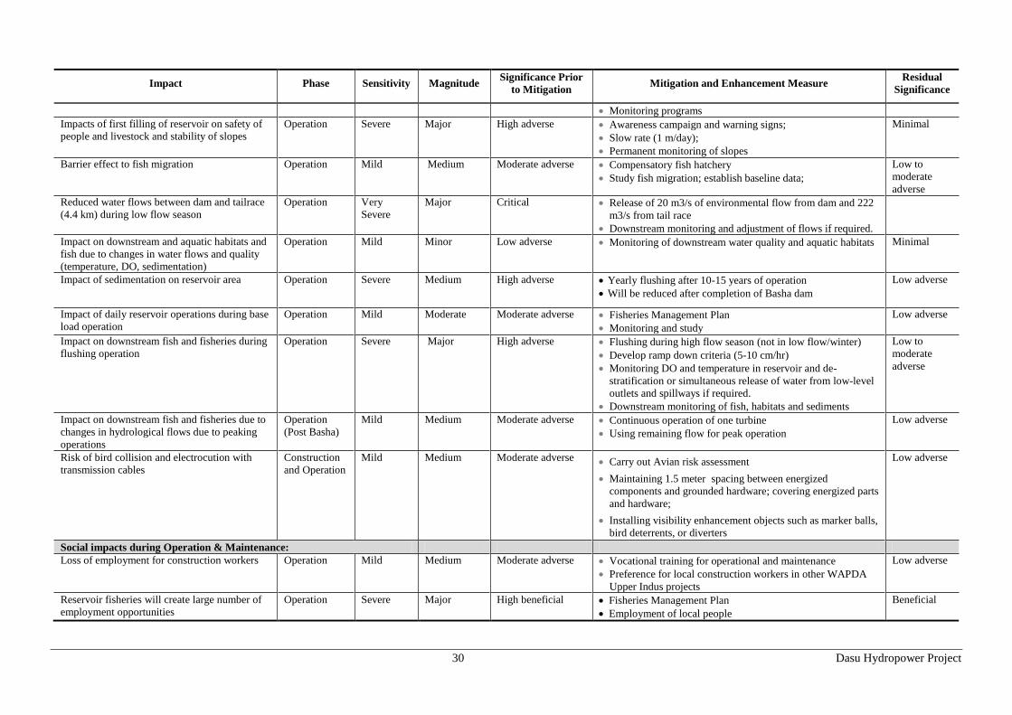
30 Dasu Hydropower Project
Impact Phase Sensitivity Magnitude Significance Prior
to Mitigation Mitigation and Enhancement Measure
Residual
Significance
Monitoring programs
Impacts of first filling of reservoir on safety of
people and livestock and stability of slopes
Operation Severe Major High adverse Awareness campaign and warning signs;
Slow rate (1 m/day);
Permanent monitoring of slopes
Minimal
Barrier effect to fish migration Operation Mild Medium Moderate adverse Compensatory fish hatchery
Study fish migration; establish baseline data;
Low to
moderate
adverse
Reduced water flows between dam and tailrace
(4.4 km) during low flow season
Operation Very
Severe
Major Critical Release of 20 m3/s of environmental flow from dam and 222
m3/s from tail race
Downstream monitoring and adjustment of flows if required.
Impact on downstream and aquatic habitats and
fish due to changes in water flows and quality
(temperature, DO, sedimentation)
Operation Mild Minor Low adverse Monitoring of downstream water quality and aquatic habitats
Minimal
Impact of sedimentation on reservoir area Operation Severe Medium High adverse Yearly flushing after 10-15 years of operation
Will be reduced after completion of Basha dam
Low adverse
Impact of daily reservoir operations during base
load operation
Operation Mild Moderate Moderate adverse Fisheries Management Plan
Monitoring and study
Low adverse
Impact on downstream fish and fisheries during
flushing operation
Operation Severe Major High adverse Flushing during high flow season (not in low flow/winter)
Develop ramp down criteria (5-10 cm/hr)
Monitoring DO and temperature in reservoir and de-
stratification or simultaneous release of water from low-level
outlets and spillways if required.
Downstream monitoring of fish, habitats and sediments
Low to
moderate
adverse
Impact on downstream fish and fisheries due to
changes in hydrological flows due to peaking
operations
Operation
(Post Basha)
Mild Medium Moderate adverse Continuous operation of one turbine
Using remaining flow for peak operation
Low adverse
Risk of bird collision and electrocution with
transmission cables
Construction
and Operation
Mild Medium Moderate adverse Carry out Avian risk assessment
Maintaining 1.5 meter spacing between energized
components and grounded hardware; covering energized parts
and hardware;
Installing visibility enhancement objects such as marker balls,
bird deterrents, or diverters
Low adverse
Social impacts during Operation & Maintenance:
Loss of employment for construction workers Operation Mild Medium Moderate adverse Vocational training for operational and maintenance
Preference for local construction workers in other WAPDA
Upper Indus projects
Low adverse
Reservoir fisheries will create large number of
employment opportunities
Operation Severe Major High beneficial Fisheries Management Plan
Employment of local people
Beneficial

31 Dasu Hydropower Project
7.4. Environmental Impacts due to Project Siting
Change in physiography: The character of the Indus River and its valley bottom will change from a fast
flowing uncontrolled sediment-laden river with steep rocky slopes into a narrow controlled water reservoir
(average width 365 m) and extending for about 73 km upstream at full supply level (fsl) (see Figure 4). In
lateral valleys of tributaries and nullahs (small streams) the reservoir penetrates several km inland and is
expected to develop similar aquatic and terrestrial natural habitats as now can be found at the confluence of
snow-fed small streams with the Indus. Farm lands on terraces along these minor streams, including small
hamlets up to a level of 957 m, will be flooded by the reservoir. The reservoir will have a depth between 100
and 175 m near to the dam. The reservoir is expected to rapidly decrease in size to only 8-9 km in 15 year
after commissioning of the Dasu dam (provided Basha dam is not commissioned in that period). During high
flow season most of the reservoir bottom will be inundated for most of the period, providing opportunities for
spawning of fish (e.g. carp species). Downstream of the main structure the topography of the lower slopes of
the valley will drastically change through excavation and blasting in order to create level terraces (154 ha) to
establish construction yards, offices, camps, housing area and disposal areas for the project.
Change in land use: Land use of about 3,900 ha will change as a consequence of the project (to be replaced
by project infrastructure, resettlement villages, reservoir and KKH). Natural and semi-natural habitats in this
area, mainly consist of steep rocky slopes covered with Artemissia and low scrub vegetation (2,380 ha), river
and nullah (1067 ha), forest patches and tree clumps (50 ha) and exposed riverine sand areas (139 ha) Around
425 ha of farmland on terraces, grazing areas and some orchards will be flooded and disappear into the
reservoir. The total area covered by the reservoir is about 2,400 ha in size. The loss of natural and semi-
natural habitats, both with limited biodiversity is relatively minor and will be partly compensated by the
natural development of a lacustrine and partly wetland environment with potential for fisheries and some
tourism development. There are no critical habitats directly influenced by the project. The loss of farmland
will be compensated under the resettlement framework and where available alternative new agricultural lands
will be reclaimed at higher altitudes. Compensation for lost assets of affected households and persons has
been indicated in a detailed eligibility matrix which is part of the Resettlement Action Plan (RAP). Livelihood
restoration (short-term and long-term) for those affected by loss of land is a major issue.
Loss of natural vegetation and trees: For the project some 21,000 trees will have to be cut, including some
2,982 fruit and medicinal trees, most of them growing in the villages and along roads. Bushy vegetation and
scrubs are usually developed on the steep slopes of the Indus valley. About 50 ha of the area is covered with
patches of forests and clumps of trees. Trees should be cut prior to the flooding of the reservoir area. Small
bushes and other vegetation can be left to be inundated. Loss of trees and natural vegetation will have an
effect on the collection of firewood. Selling of fire wood is an important source of income for the population
of the project area and a common practice along the KKH both in winter season (heating and cooking) but
also in summer season (cooking). People will move to higher places in order to collect firewood. It is expected
that the Project will attract about 7,000 in-migrants. This influx will create a huge demand for firewood due to
increased energy requirements for cooking and heating during winter. This is expected to increase the pressure
on forest resources at higher altitudes. Mitigation of the loss of trees is included in the eligibility framework
laid out in the Resettlement Action Plan, and will also be compensated by planting trees (at a rate 5:1) near the
new resettlement sites, in WAPDA colony, and along roads. The Project will also support the local
government to establish a market for the supply of non-timber fuels such as LPG for cooking and heating in
order to reduce the pressure on firewood. At higher altitudes a project plan for afforestation and rejuvenation
of forest will be prepared and implemented. According to WWF-Pakistan this can only be done after an up-
dated GIS forest inventory of Kohistan has been carried out. Such an inventory should be included in a forest
and wildlife management study which should be implemented during the construction phase of the project
(see also section 7.5 under increased pressure on high altitude forests).
Impacts on natural habitat. The DHP reservoir would cover about 2400 ha of the area, which includes
permanent flooding of about 1800 ha of natural terrestrial habitat. Most of the affected terrestrial habitat is
covered with barren rocks and slopes with little vegetation. Based on analysis of satellite imagery and field
surveys, the affected land is mostly covered by barren slopes/rocks (61 percent), followed by river/nullah (27
percent), grazing land/pasture (6 percent), exposed sand (3.5 percent), vegetation cover (1.3 percent),
cultivated land (0.92 percent), and houses (0.13 percent). The key impact would include loss of about 82 ha
of natural habitat from the Kaigah Community Game Reserve (KCGR) (including the affected area by KKH
relocation). Kaigah nullah is the location of a designated Wildlife Community Conservation area (5000 ha)
where trophy hunting of markhor sheep is allowed.

32 Dasu Hydropower Project
Figure 4: Reservoir Area

33 Dasu Hydropower Project
The area is bordered by the KKH and located at short distance of the proposed quarry site. In the area limited
hunting of markhor sheep (one license only) is allowed by the KP wildlife department. With the proceeds of
the yearly auction of hunting right a number of community development activities are financed, including
construction of a few hunting lodges About 1.6 percent from the 5,000 ha area of the game reserve will be
permanently affected by the Project due to reservoir submergence and KKH realignment. The rest of the area
will be temporary affected by noise from construction activities. The permanently affected area is located on
the lower elevations of the reserve, which is mainly inhabited by the community of Kaigah village and
consists of residential areas, some agricultural fields, grazing areas, and also an existing quarry site. The
construction related impacts are discussed later in this Chapter. In addition, there will be loss of about 160 ha
natural habitat along the tributaries and about 1550 ha of other natural terrestrial habitat with low biodiversity,
consisting mainly of gravelly and rocky mountain slopes, often sparsely vegetated and very steep slopes.
Other natural habitats which might be indirectly affected by the project (through resettlement of people) are
the natural forests and grazing areas mostly located at higher altitudes (> 2000 masl). These areas often
covered by Himalayan temperate forests and Alpine forests, are already under severe stress. To mitigate the
potential impacts on these areas, the Project will support the identification and development of two
compensation areas (off sets) for conservation of natural habitat and wildlife. A study will be carried out to
identify these sites and recommend two of them to be developed as offset areas to conserve natural habitat and
wildlife in compliance with World Bank OP 4.04 on Natural Habitat. The Project will also support
afforestation and forest rejuvenation programs in the higher altitudes for the conservation and sustainable
development of forest ecosystems in compliance with World Bank Policy OP 4.36 on Forests.
Impacts on physical cultural resources in project area: The 400 year old historic mosque in the village
Seer Gayal will be flooded by the reservoir, together with the houses of the hamlet. In consultation with the
local community it was agreed that the wooden structures will be disassembled, transported and reassembled
at a higher altitude at the new location of the village. Also 16 graveyards spread over the valley will be
submerged by the reservoir. With the various communities alternative proposals for mitigation were
discussed. Most communities preferred to leave the graves at the place of burial. Other cultural resources that
will not be submerged but should be protected against adverse impacts from the project are the burial ground
in Seo, which is near to the disposal areas and the cluster of petroglyphs (rock carvings) near Shatial, which is
part of a much larger field of 50,000 rock carvings extending from Shatial over more than 100 km towards the
bridge of Raikot. This is one of the largest fields of rock art in the world, with carvings dating from Stone Age
(9th millennium BC to Buddhist period. The project will support the KP Archaeological Department in
procuring land of the rock carvings of Shatial, providing proper fencing and protection of the carvings and
developing tourist facilities at the site. Also support in documentation will be provided, In case of any chance
finds discovered during construction activities, the works will be stopped in the area and the Archeological
Department will be informed. Provisions for this will be included in the contracts and a qualified archeologist
will be on standby during the construction period. Furthermore, archeological survey will be carried out by an
archeologist engaged by WAPDA before the commencement of construction activities in the project area to
identify any PCR sites/artifacts.
Impacts due to increased traffic and transportation: During design stage and during mobilization of the
contractor, traffic along KKH and in the twin city of Dasu-Komila will increase and this will boost up even
further as soon as construction has started. This will lead to congestion at certain places like main street,
central markets and bus stops. Apart from congestion there will be increased air pollution and noise at these
places. This might result in friction with shopkeepers, hotel/restaurant owners and general public. Road safety
will decrease and risk of accidents will increase. In order to be prepared for this situation a transportation and
traffic management plan should be prepared by the Project Management Unit (PMU) in cooperation with the
contractors and the local authorities. This plan should include a proposal for a by-pass road along the main
markets of Komila. In total about 13 km of by-pass roads are foreseen.
Inundation of 52 km of KKH: Around 52 km of the KKH will be submerged by the reservoir. This part of
the road lies between Dasu and Shatial. A new alignment will be constructed at a higher level on the left bank
of the Indus. A total of 65 km of highway will have to be constructed, including 10 km of road downstream of
the dam and a link road of 3 km length. Five new bridges in the KKH will have to be constructed crossing
nullahs and small streams. About 45 ha of land will have to be acquired for road construction purposes.
Loss of access to villages: Two suspension bridges over the Indus connecting both river banks and some
secondary access roads on the right bank will be lost. As compensation for these losses a new suspension
bridge near Kandia and a total of 35 km of new access roads, from Komila to Kandia bridge, will have to be
build, all at a higher level of the right bank of the Indus. A new jeepable track of 18 km along the right bank

34 Dasu Hydropower Project
north of Kandia bridge will provide access to the villages on the right bank. All new settlement sites should be
provided with good access roads. Other existing facilities for pedestrians to cross the river, such as foot
bridges and cable cars should be replaced by appropriate alternatives.
7.5. Social Impacts during Pre-construction Stage
Land acquisition for the project: A total of 4,643 ha of land will be acquired for the project (not including
the future 500 kV Transmission Line). This includes 2,778 ha for the reservoir (which is land below the 1,000
m contour), 174 ha for physical project infrastructure and 205 ha for construction of roads (KKH and access
roads). In the area to be acquired apart from natural wasteland some 425 ha of agricultural land are included,
consisting of farm land, grazing areas and orchards. Family income from land in terms of crops, fodder and
forest products will be lost. This will require proper compensation measures, resettlement at higher altitudes
and assistance including livelihood restoration. Agricultural compensation is rather problematic since new
cultivable lands at higher altitudes are extremely scarce and generally low in fertility. New sources of
employment and living have to be sought. According to inventory surveys and a census, a total of 767
households consisting of some 6,953 persons, more or less equally divided over both river banks will be
affected by the project and will have to be resettled above 1,000 m or elsewhere. A RAP has been prepared to
address and mitigate the impacts on the affected households. The objective of the plan is to restore the income
and livelihood conditions of the people to at least pre-project level. The households affected will not only
receive cash compensation for land based on rate basis negotiated by the District Collector with the affected
communities/Jirgas for land, structures and other assets, but also will be given additional assistance for
relocation, re-employment and livelihood restoration. Temporary leasing of land might be needed for the
period of construction for installing of construction facilities such as batching plant, construction workshops,
labor camps and borrow areas.
Relocation of inhabitants of 34 hamlets: The footprint of the project will affect 34 hamlets and villages,
each of them often consisting of not more than 25 to 30 houses. A total of 923 structures will be lost of which
83 percent are residential structures. Given the past experience of resettlement in Pakistan and the Dasu
project context in particular, the Project has adopted a community based relocation strategy to sites in upper
elevations. In this approach the community will be relocated to sites of their own choices at higher elevations
and is characterized by: (i) community decision making with regard to site layout and civic amenities to be
established;(ii) site and services development at project costs; (iii) subsidized plots for each affected family of
the concerned community settling on higher elevations; and (iv) shifting and reconstruction grants as per the
entitlement matrix. The approach for community preferred sites was well received (90 percent) and considered
practical by the jirgas, as well as at stakeholder workshops. Only a limited number of affected households
(10 percent) want to move on their own to other places in Kohistan and as far as Mansehra and Abbottabad
mentioning their kinship links in those places and/or availability of cheaper land for resettlement, including
more job prospects in the cities. This may be a feasible option on household basis. These choices and
responses will be further confirmed at the implementation stage. This will be a dynamic process. While
maintaining the main thrust, Dasu Project Management and team will adapt a flexible and open attitude
towards people’s requests and continue to explore potentials options. But all resettlement options, requests
and agreement will be subject to careful technical assessment, review, consultation and agreement with the
concerned communities.
Relocation of 50 shops and commercial establishments: Most of the commercial enterprises affected by the
project are located on the left bank of the Indus, near to the KKH. The commercial enterprises on the right
bank usually consist of residential houses with a small shop as annex. Compensation and/or resettlement
assistance is worked out in details in the RAP and the Resettlement Framework.
Loss of civic amenities: A survey of 27 villages out of 34 villages revealed that there are 31 existing
mosques, seven schools, two basic health units, three community centers and 17 graveyards, next to facilities
for drinking water supply and irrigation, and latrines. Surveys of community assets for the remaining villages
are ongoing. . Most of the affected villages have direct access roads from KKH (left bank) or internal access
roads (right bank). The RAP has provisions for reconstruction of these civic amenities at new sites in upper
elevation as desired by the communities, including the provision of electricity.
Loss of 425 ha of farm land, grazing area and crops: About 600 families that are presently involved in
terrace agriculture will lose their crops in the lower valleys and along the banks of the Indus River. . However,
many have lands in high-altitude lateral valleys where crop production is possible during the warmer summer
season. The combination of summer and valley crops is sufficient for family consumption requirements (there
is no local market). Many farm families focusing on limited terrace cultivation will continue with crop

35 Dasu Hydropower Project
cultivation at higher elevation. Livestock herding on higher altitudes during summer will continue, but the
winter part of this activity, along the river embankments will cease after the construction of the dam project.
In order to mitigate these adverse developments an adequate livelihood restoration program has been
developed in order to sustain and improve agriculture and livestock herding. Simultaneously, new
opportunities such as reservoir fisheries development, a forest rejuvenation and management plan and
provision of temporary employment and additional income in clearing of vegetation and trees in the reservoir
area, and other social development activities have been designed in the RAP and EMP.
Increased pressure on high altitude grazing area and forests: Resettlement of 767 families above 1,000 m
altitude will mean that pressure on the mountain zone between 1,000 and 1,500 m and higher will increase.
Especially the grazing areas and forests around 2,000 m are currently already under pressure, resulting in
deforestation, erosion and decrease of flora and fauna. The pressure will certainly increase as a consequence
of the project. As mitigating measure the implementation of a forest management plan is envisioned, with the
objective of rejuvenation of forest and sustainable management of forests and grazing areas at higher altitudes.
This project will be implemented as part of the EMP with support of the livelihood restoration program.
Impacts of the construction of the 132 kV power supply line to project and colony: The construction of
45 km of transmission line for power supply of the project during construction will require that land should be
acquired for the footprint of the 233 towers of the line. Total land acquisition is low (about 1 ha) and no
resettlement is expected. There may be other impacts such as crops, trees, structures and restriction on the use
of the corridor lands. Detailed impact surveys will be carried out and compensation plans will be prepared
following the project resettlement policy framework already developed as part of the SRMP.
Generation of employment in the region: Currently only 26 percent of the population is employed, most of
them are self-employed in agriculture or livestock holding or as small shopkeeper. From those working about
17 percent works as unpaid family helper. Only 12 percent is working as employee. The project offers good
opportunities for local residents to apply for employment as unskilled and skilled construction worker. Within
the construction contracts the contractor(s) would have to attract local workers and technicians on basis of
agreed quota. Construction works could offer at least for a period of 10 years many opportunities for unskilled
workers and technicians. There will also be employment opportunities for office staff, administrative and
logistic functions and in transportation. Important for sustainable livelihood restoration is that sufficient
vocational training and skill development is provided. A pro-active program to this end is already started by
WAPDA: local youths are receiving a six-month vocational training in various lines of work to prepare them
for guaranteed jobs in the project construction work. Establishment of vocational training centers for men and
women will be part and parcel of the project resettlement plans. After the construction phase there will be
other opportunities for more permanent functions within the project operation and maintenance. All these new
opportunities for work for local residents could boost employment and improve the social and economic
position of the population. This will be a major and significant positive impact of the project.
Increased economic activity: The considerable influx of people during all phases of the project (up to 12,000
during construction) will considerably stimulate the local economy, by involving local businesses and village
level enterprises. New opportunities for local businesses, suppliers, hotel owners, shopkeepers and the
transportation sector will be created. All these developments will stimulate the local economy in the district.
7.6. Environmental Impacts during Construction Stage
Increased traffic on KKH and local access roads: The KKH is the life line of northern areas and it is the
only highway connecting China and the north of Pakistan with the rest of the country. About 2,590 vehicles
per day including 200 heavily loaded trucks are currently using the KKH for transportation of goods. During
construction of the project it is estimated that daily 200- 300 extra trucks, needed for the supply of
construction materials, will make use of the KKH. Additional project vehicles using the KKH and exceptional
heavy transports of turbine sections may cause traffic congestions and safety hazards. The access road to the
project along the busy Komila bazaar and those from borrow areas and to deposition sites are also expected to
create traffic problems and safety hazards. To mitigate these problems the contractor(s) will be required to
prepare Traffic Management Plans coordinated and supervised by the Project Management Unit (PMU) and in
cooperation with the local authorities. This plan should include safety measures, traffic control measures,
provision of by-passes at busy places and provisions for repair of damage caused by project vehicles.
Impacts on Kaigah Game Reserve: Noise and vibrations from blasting and excavation operations from the
quarry (duration estimated at 2.75 year) together with 5.5 km of KKH construction within the borders of the
game reserve (duration estimated at 7-8 months) will have negative impacts on wildlife. Most wildlife habitat
in the reserve is primarily located at some 3 to 5 km distance from the construction activities higher up into

36 Dasu Hydropower Project
the mountains. Most impacts will probably be limited to lower altitudes - areas that are likely to be avoided
by the wildlife most of the year. The project may also result in a reduction of community income for
conservation management during the years of construction. This income forms a share (80 percent) of the sale
of hunting permits (trophy hunting). Controlled and optimum blasting and regular monitoring should be done
in order to comply to international standards to avoid as much as possible impacts on wildlife. The impacts on
people, wildlife and hunting activities should be strictly monitored and compensation should be paid for the
losses of income during quarrying and crushing activities in the area (estimated 2.5 to 3 years) and the
construction activities for the KKH (estimated 7 to 8 months) in the reserve. The community will be consulted
and involved in promoting and strengthening ecological conservation measures in the game reserve.
Impact on river habitat due to construction activities in the river: At the dam site coffer dams will be
placed upstream and downstream of the work areas to keep the river bed dry for about 980 m length to
facilitate construction of the dam. Aquatic biological production will be eliminated from approximately 980m
of stream length, part of which (the dam footprint) will be removed for the life of the dam. Pre-construction
and construction activities have potential to adversely affect aquatic biota by release of high concentrations of
sediment, fuels/oils and other toxic compounds, and solid waste and use of explosives. High sediment loads
will be produced during placement of the coffer dams and again when water first passes through the work area
after completion of dam and plunge pool construction. Sediment concentrations above natural levels can cause
mortality of biota directly; for fish, damaged gills and sediment clogging of gill chambers eventually leads to
death. Measures proposed in ECPs to protect the water quality will mitigate potential effects on fish.
Entrainment and Mortality of fish: The construction of Indus water diversion tunnels where high water
velocities may develop will have impact on fish. Fish trying to move downstream in water conduits such as
diversion tunnels, powerhouse intake tunnels, lower level outlets and spillways will potentially be subjected to
high levels of mortality and injury. Inlets will have to be protected either with electric or acoustic methods to
prevent fish from being caught by the flow.
Potential risk of air, soil and water pollution: During construction there is a high risk of accidental spills
and leakages that may occur from fuel and oil tanks, vehicles and machinery and storage of chemicals used in
construction areas, yards, batching plants, quarry areas, worker camps, residential areas and from storage
sites. These spills can pollute soils and contaminate surface water and groundwater in the area. Air pollution
may occur by emissions from construction related traffic and machinery. A Pollution Prevention Plan should
be prepared prior to the start of the work. Proper baseline data of soil, air and water quality of surface and
groundwater should be collected in advance. Moreover the contractor(s) should implement the measures
prescribed in the Environmental Code of Practices (ECP), which will be included in the contracts. Contractors
should take appropriate measures to avoid and contain any spillage and pollution of the soil and water
resources both upstream and downstream of the dam. Construction equipment and vehicles should be well
maintained, so that emissions are minimal. Dust generation from construction sites would be restricted as
much as possible and water sprinkling would be carried out as appropriate, especially at those places where
earthmoving, excavation and blasting will be carried out. Air quality would be properly monitored, especially
near the population centers and WAPDA colonies. Detailed ECPs are included in the main ESA volume.
Potential loss of land in disposal areas: With the construction of tunnels and underground chambers for
housing the powerhouse and switch yard facilities huge quantities of rock will have to be excavated and
brought to the surface. It is estimated that the quantity of rock to be excavated will be 10.25 million m3,
excluding the excavations from KKH. Around 7.2 million m³ will be generated in the first phase. Part of the
excavated rock can be used as concrete aggregate provided the fragmented rock meets the quality standards
needed for the work. Mixing with fresh quarried rock is possible. In order to reduce the amount of rock to be
disposed, excavated rock can be used in the project for different types of infrastructural works, including road
construction. The remaining spoil will be disposed in designated and safe disposal areas. Several potential
disposal areas have been identified. Potential risks of pollution of (ground)water resources by excavated rock
material containing heavy metals will have to be verified by the contractor(s). A re-use plan for excavated
material and a spoil disposal plan should be prepared in advance.
Noise and dust generated by construction works, increased traffic and use of explosives: It has been
estimated that at least 20,000 ton explosives will be used for excavation of tunnels and rock chambers and for
construction of the main structure and the road. Apart from noise produced by blasting and drilling operations
a lot of noise and dust will be produced by excavation equipment, other machinery, concrete mixing, and
traffic from trucks and vehicles. The city of Dasu-Komila and the village of Seo are very vulnerable for
increased noise from traffic. Noise levels may exceed the national standards. Noise of explosions and ground
vibrations will be common during excavations. At low to medium levels, ground vibrations and air blasts can

37 Dasu Hydropower Project
result in community annoyance. At higher levels this could lead even to structural damage on buildings. As
mentioned earlier the use of explosives could also scare away wildlife at the Kaigah Community-managed
game reserve and elsewhere in the project area. Continuous monitoring of noise levels is essential, as well as
continued consultations with the affected communities.
Increased risk of landslides: During construction there is an increased risk of landslides and collapse of
slopes. Landslides are natural and common phenomena in the project area and along the KKH. Landslides in
freshly-cut slopes can occur due to lubrication or saturation of rock support structure by rainfall or by water
seepage. The use of explosives to break the rock will have the capacity to generate vibrations which can
trigger a landslide. Landslide- prone areas in the project area have been identified and classified on basis of
potential risks. Any blasting activities in these areas should be controlled and contained within defined limits.
Pro-active measures should be developed to stabilize and protect slopes and to protect workers safety. Access
would be restricted during the periods that slope stability is not yet entirely secured and guaranteed by proper
safety measures such as rock bolts, anchors, safety nets and gabion structures. Permanent monitoring by the
contractor is required.
Impacts of increased human activities on flora and fauna: Human activities during construction will
strongly increase in the area with the influx of 7,000 in-migrants that will include construction workers and
technicians, suppliers and business men and followers. The population increase will create a huge demand for
firewood due to increased energy requirements for cooking and space heating during winter, and will finally
increase the pressure on community forest resources. Contractors should include provisions in the contracts
for the supply of non-wood fuels such as LPG to the construction staff for cooking and heating purposes and
the project should support development of LPG market in Dasu. The project will also support the
improvements required for community forestry management. A forestry management study is proposed during
preconstruction stage of the project to identify and develop forestry management opportunities. The
population increase will also cause a strong pressure on the local environment by increased pollution, noise,
disturbance, hunting, poaching and fishing. For the work force these impacts such as disturbance and
poaching can be reduced by the Contractor by introducing and enforcing a Code of Conduct and raising of
awareness on protection of flora and fauna. In addition, WAPDA will maintain liaison with the concerned
departments and local community for the protection of the forest and wildlife of the area.
Risk of water pollution from storage tanks: Through the conversion of the Indus valley into a reservoir the
available oil tanks and underground storage containers (chemicals, lubricants, and pest control agents) will be
submerged, with the risk of serious pollution of the water of the reservoir. Those potential sources of pollution
should be identified and removed during the construction period and prior to the first filling of the reservoir.
Risk of pollution from solid waste and waste effluents: Large construction works are generating large
quantities of excess materials from construction sites (concrete, steel cuttings, discarded material) and wastes
from field camps and construction yards, including garbage, recyclable waste, food waste, and other debris. In
addition small quantities of hazardous waste will be generated from maintenance activities, contaminated soil,
oil filters and other waste products. The contractor will identify suitable sites for disposal of hazardous and
non- hazardous waste. The selection will be done in consultation with the PMU and the local municipal
authorities. Protocols and measures will be prescribed in the ECPs to be included in the contracts with the
contractors. Siting of any fuel and hazardous material storage sites, including refueling facilities, asphalt
plants and construction yards are to be located minimal 100 m from the banks of any streams and at least 500
m away from any residential areas, cultural or archaeological sites.
Shortages and/or negative effects on local water supply and sanitation: The influx of large numbers of
workers, technicians and staff employees and their families will require well-organized drinking water supply
and sanitation facilities. Various stakeholders might draw from the same available groundwater resources. A
Drinking Water Management Plan, based on separate water supply and sanitation for the work force, will have
to be prepared by the contractor. In designing such a plan it is important to maintain and safeguard the water
supply and sanitation facilities for the local population.
Disturbance of visual landscape: The project will drastically change the visual landscape at the site of
project and especially at places where slopes have been excavated for construction of roads and project
infrastructure, at disposal sites and in borrow areas. Proper landscaping will have to be done and an overall
Landscape Plan will have to be prepared, that will be worked out in more detail for the area where the project
infrastructure is located. Also landscape plans for the residential areas and the offices should be developed to
create a good living and working environment. Tree planting should be well organized and where possible
vegetation and natural habitats will have to be restored

38 Dasu Hydropower Project
7.7. Social Impacts during Construction Stage
Safety hazards due to increased traffic for children and elderly people: The construction activities can
potentially impact the residents of Dasu-Komila and along KKH, particularly the movement and safety of
school children. In addition, due to increased use of trucks and other vehicles on the narrow roads in the
project area and the access roads pedestrians, particularly elderly people and children will be more exposed to
dangerous situations, which may lead to traffic accidents. A Traffic Management Plan will be implemented
that will aim at ensuring access to residential areas, and preventing of unsafe situations, especially near
schools, housing areas, construction areas, camps and offices. There will be appropriate medical services and
a facility with the capacity to treat emergency cases and trauma patients.
Social conflict due to the influx of workers and in-migrants: The project construction will bring significant
changes in the lives and livelihoods, including new opportunities for employment and income for the local
people. The development also attracts thousands of new in-migrants to the project area. Through the influx of
workers, business people and followers the population of Dasu-Komila will increase more than three times
within a few years. Unless properly managed this sudden influx of people could create negative aspects such
as an increased crime rate, tensions and social conflicts between the various groups. In order to prevent such
problems the project will develop a pro-active approach by working out a Migration Management Plan
(included in the Management Plan for Construction-related Impacts – Volume 8 of SRMP), even before
arrival of the first in-migrants. In this plan detailed solutions for a number of key issues will be prepared
including issues regarding housing and accommodation, food security, local infrastructure, community health,
labor contracts, employment and business opportunities, security, integration and cultural understanding and
community and area development. In this Plan procedures and rules will be worked out by the PMU in close
cooperation with the contractors and local authorities.
Respect of local cultural norms and values by work force: Workers coming from different parts of
Pakistan may have norms and values in social behavior and religion that differ from those of the resident
population. This situation will be addressed by an awareness campaign implemented in the beginning of the
construction phase. The contractors would be aware of the possibility and risks of miscommunications
between local residents and workers, a situation which easily could lead to social unrest. This would be
prevented by raising awareness and implementation of a Code of Conduct for the workers.
Reduced safety and adverse effects on health situation: The influx and accommodation of a large work
force will result in increased concerns for the safety of local population particularly women and children.
These concerns would be addressed by raising awareness of the associated risks for the local population. The
awareness campaign will also be aimed at the risk of interaction between the resident population and the
construction work force, including the spreading of sexually transmitted diseases. Apart from awareness
raising and prevention the medical health facilities in the project area will be facilitated to deal with such
incidences. Measures to this end are included in a Public Health and Safety Plan that will be implemented.
Increased load on local services and supplies: The project area is situated in a remote area far from the main
population centers of the country. Especially in the beginning of the project there will be a limited presence of
shops, markets, service providers and suppliers of commodities. With the presence of a considerable work
force in the area there could be shortage of supplies for the resident population, especially since the area is
dependent from supplies transported along the KKH, which is often blocked for one or more days This
potential impact would be mitigated by requesting the contractors to procure their supplies in a manner not
significantly affecting the availability of essential commodities in the area for the residents.
Increased risk of accidents for workforce: The rough terrain and difficult work conditions in some parts of
the area will need extra attention from contactors and project management for the increased risk of accidents,
unsafe working conditions and health risks. This is especially true for underground work in tunnels and
caverns, but also during excavation and construction work. The contractors should follow closely the IFC
Performance Standard on Labor and Working Conditions, as well as World Bank Group Environment, Health
and Safety (EHS) guidelines. Special attention should be focused on safety training for workers to prevent and
restrict accidents and on the knowledge how to deal with emergencies.
7.8. Environmental Impacts during Operation and Maintenance
Impact on 570 ha aquatic habitat of the Indus and Indus tributaries through the creation of a reservoir.
The character of the river Indus and its valley bottom will change from a fast flowing uncontrolled sediment-
laden river with steep rocky slopes into a narrow controlled water reservoir (average width 365m) and
extending for about 73 km up stream at full supply level of 950m. In lateral valleys of tributaries the reservoir
39 Dasu Hydropower Project
penetrates few kilometers inland. About 570 ha of river and tributaries will be subject of biotic and abiotic
changes caused by the reservoir. Reservoir ecology will not be typical of a natural lake environment and will
undergo rapid reduction in size caused by rapid sedimentation. Water velocities along the length of the
reservoir will generally be lower than in pre-reservoir river conditions. Although reservoir features will be
lake-like, surface water velocities will be high compared to most lakes and storage reservoirs. The relatively
high water velocities suggest that conditions may be mainly compatible for riverine fish species, particularly
along the reservoir shoreline. Spawning areas in the tributaries will be submerged and it is expected that new
natural spawning areas could develop at the confluence of tributaries with the main water body higher up.
Maintenance of these new and existing spawning areas could stimulate a proper shallow aquatic habitat with
sufficient places for hiding and feeding for fishes, including snow carp and other species. Developing a fish
hatchery for production of native snow carps (snow carp hatcheries are already established in India and Nepal)
and stocking of snow carp in the tributaries and reservoir is recommended to compensate for the loss of
habitat and fish catches through DHP. Further studies are recommended during construction and operation
stage to establish detailed baseline data on aquatic ecology and to carefully monitor the actual impacts, in
order to develop additional offset measures and research on hatchery development as required.
Impacts of first filling of reservoir on safety of people and livestock and stability of slopes: Upon
completion of the main structure the reservoir will be filled at a slow rate. First filling is possible both during
high or low flow season. But the most optimal and easiest period is to start around mid-June in the beginning
of the high flow season. The water level rise is expected to be around 1-2 m per day. This slow rate is
maintained in order not to destabilize the slopes of the valley and to prevent landslides and it will also provide
an opportunity for most of the terrestrial fauna to escape to safe heights. Within hours the water level will
reach the Low Level Outlets (LLO). From this moment the water level rise will be controlled by opening the
LLO’s in the main structure and releasing the extra inflow into the river. The entire first-filling operation will
take about two months. During the entire period of filling the flow from the reservoir to the Indus downstream
will be slightly reduced. In total about 2 percent of the total annual water flow is needed to fill the reservoir.
Since the operation is implemented in the beginning of the high flow season, the reduction in the annual water
flow needed for filling of the reservoir will be hardly noticed and is not expected to affect the downstream
water flow, the aquatic habitats, fisheries and irrigation requirements. Once after the full supply level (950 m
asl) is reached the LLO will be closed and whatever additional water is coming into the reservoir will be
diverted through the intake tunnels to the powerhouse and after power generation released through the tailrace
tunnels. At this stage the “run-of-river” operation is reached, which means that the flow downstream reflects
the natural flow conditions of the river. The impact of first filling of the reservoir and the subsequent
operation of the plant on the hydrological regime of the river thus are minimal. During the high flow season
(June-September), when water will enter the reservoir at a rate greater than the water diverted through the
power inlets (2600 m3/s), the additional water will pass over the spillway.
Barrier Effect on Migration of Fish: By constructing the main structure in the Indus a barrier in the river
will be created, which will impair the ecological connectivity in the river, including the movement of biota
and the migration of fish. Fish production in the Indus River within the project area is low, the main reasons
being the fast torrential stream, the cold, glacier-fed water, the high sediment load, and the low trophic level
of the water. No long distance migratory fishes are present in the project area that could be affected by the
dam. Snow carp migration is within the tributaries and hence will not be affected by the dam. Further studies
will be carried out (during pre-construction/construction) to strengthen the existing knowledge on fish biology
and ecological baseline for the Indus corridor between Raikot and Tarbela in order to better interpret and
mitigate actual impacts of DHP and to be able to prepare adequate offsetting measures on fish and fisheries of
Dasu as well as other hydropower projects in the UIB such as the Diamer-Basha dam.
Reduced water flows between dam and tailrace: The river reach between dam-axis to tailrace discharge
point is about 4.8 km long (Zones A and B in Figure 5). From June to September, when the average river
flow is higher than 2600 m3/s (the flow required to run all turbines), the excess water will be discharged
through the spillways/LLOs thus maintaining (a minimum of 165 m3/s in September to a maximum of 3980
m3/s in July) flow through the Zones A and B. However, from October to May, when the average flow is less
than 2,600 m3/s, there will be no water released downstream of the dam and all the water will be diverted to
the power house and will be released to the river through tailrace outlet. A small tributary - Sieglo stream -
joins the Indus in this reach (about 1.2 km downstream of dam). The average annual runoff from Sieglo
stream is 1.7 m3/s with average runoffs less than 0.5 m
3/s during low flow season, which indicates most part of
this section will be dry during low flow season. Nearly 0.4 km of this section covers the dam structure and
plunge pool. Thus the distance between the plunge pool to tailrace is about 4.4 km. The reduced water inflow

40 Dasu Hydropower Project
in this river section of 4.4 km length can potentially cause significant impacts on the aquatic fauna and overall
ecology of the river in this reach. However due to a favorable profile of the riverbed (Figure 5), a section of
3.2 km length (Zone B) upstream of the tailrace could permanently receive water from backwater flow from
the tailrace during run of river base load operations. Only 1.2 km of river below the main dam (Zone A) is
critical for drying up during the low flow season. However, in case of peaking operations in low flow season
(in Stage 2), Zone B is also affected during reservoir storage period of 18 to 20 hours.
Figure 5: River Profile and Water Levels on the Downstream of the Dam site
Need for Environmental Flow: An environmental flow is the volume of water that is needed to sustain the
aquatic ecosystem of the river and to cover the downstream requirements such as domestic use, irrigation,
groundwater etc. There is no human use of water (e.g. drinking, irrigation, cultural use, etc.) in the river
section between dam and tailrace. All villages in the project area depend on tributaries for drinking water and
irrigation requirements. The only ecosystem that is likely to be affected in this river section due to reduced
flows are the low flow season (wintering) habitat of snow carps, especially near confluence with Sieglo.
Maintaining an environmental flow downstream of the dam could mitigate potential impacts on the habitat of
snow carps. To mitigate these impacts, environmental flows of 20 m³/sec from the dam and 222 m³/sec from
the tailrace (releases from operation of one turbine) are recommended for DHP. Two approaches were
followed in determining these recommended environmental flows. The first is the experience from the Ghazi
Barotha hydropower project located on the Indus 10 km downstream of Tarbela. The second is based on
hydraulic modeling in order to determine the required water flow needed for sustaining the snow carp habitat.
A 5-year monitoring program conducted by WAPDA Environmental Cell (WEC 2009 Social and
Environmental Monitoring assessment of Ghazi Barotha Hydropower Project) concluded that an
environmental flow of 28 m³/s is sufficient to meet the requirements in this project (aquatic habitat, irrigation
and drinking water). On basis of these finding an equivalent flow of 20 m3/s is needed at DHP. A hydraulic
modeling study was also conducted to simulate the environmental flows of 20 m3/s from dam and 222 m
3/s
from tailrace with respect to the hydrological features of Indus (wetted perimeter, water depth and water
velocities) at various locations between dam and tail race (Zones A and B in Figure 5) and comparing these
with the requirement of snow carp habitat, especially at confluence with Siglo nullah. The model shows that
the flow will maintain adequate depths (0.5 to 0.6 m) and velocities (1 to 2 m/s) to support the winter habitat
of snow carps. Hence environmental flows of 20 m3/s from dam and 222 m
3/s from tailrace are recommended
for the DHP.
During peaking operations in Stage 2, one turbine will always be operated to release the environmental flow
of 222 m3/s from tailrace, in addition to 20 m
3/s through the dam. These environmental flows will maintain
about 44 percent of average winter flows and 72 to 95 percent average winter wetted perimeter in Zone B (3.2
km long). In Zone A (1.2 km long), they represent 4 percent of average winter flows, 20 to 25 percent of
average winter depth, 34 to 45 percent of average winter wetted perimeter. During peaking operations in Stage
2, these environmental flows also represent about 44 percent of average winter flows on the downstream of
tailrace. A downstream environmental effects monitoring program will be put in place to enable assessment of
changes in ecological components and adjust the environmental flows if required. The international panel of

41 Dasu Hydropower Project
experts (IPOE), during its third mission in November 2013, has carefully reviewed the above approach to
assess the environmental flows and approved the recommended environmental flows.
Impact on downstream fish due to changes in water flows and quality: Generally water quality in
reservoirs will be deteriorated to thermal stratification and depletion of dissolved oxygen at deeper levels.
Average water retention time (residence time) in the reservoir (volume/flow per unit time) is an important
determinant of the extent of the change in water quality. Generally, long retention times in the reservoir will
affect the reservoir water quality through changes in dissolved oxygen, eutrophication and thermal
stratification. Average water retention time in Dasu reservoir will be very short varying from one to six days
during high flow season, and about 19 days during low flow season. The impacts on water quality are
estimated to be minor due to the relative short retention time. Some changes in water quality may occur over
short distances downstream of the dam, but these are not expected to have significant adverse effects.
Changes in downstream sediment quantities are not expected to negatively affect downstream aquatic life and
may favor species that will benefit from reduced amounts of sand and gravel in seasonal deposition and
scouring cycles. About 98 percent of the sediments occur in Indus basin during months of high flows of June
to September, during which water passes through spillways, low level outlets and turbines. Sediment trap
capacity of DHP is about 60 percent, which means about 40 percent of the annual sediment load will be
continued to be transported downstream of the dam; and sediments also will continue to enter the main stem
through tributaries located downstream of the dam. The first major tributary below the dam site is Jalkot at
some 9 km distance from the dam. A downstream environmental effects monitoring program will be put in
place to enable assessment of changes in ecological components.
Impact of sedimentation on reservoir area: Annually some 200 million ton of sediment is entering the
reservoir area. After completion of the Dasu structure the reservoir will be filled and flow velocities in the
reservoir are strongly reduced causing most of the sediment to be deposited in the reservoir. The coarser sandy
sediments will settle near the upper reach of the reservoir and the finer sediments will settle in the middle and
lower reaches. This sedimentation will reduce the reservoir storage capacity over the years to come. Without
flushing of sediments, it is expected that the inlets of the LLO and power intake will be blocked in 20 to 25
years. The storage volume of the reservoir will then be reduced by more than 80 percent and the length of the
reservoir will be about 10 km long (at fsl). To prolong the life of the reservoir (at least to 40 years) it is
estimated that annual flushing should start after 15 years. For the first 15 year period the impact of
sedimentation on potential development of commercial fisheries is expected to be minimal, provided that
stocking of the reservoir is carried out with suitable native non-migrating fish species adapted to the
circumstances in the reservoir. The situation can be compared with the situation at the Tarbela reservoir.
Habitat conditions along the 73 km length of the reservoir (at fsl) will be characterized by a transition of the
fast-moving river-like flow in the upstream end of the reservoir (water velocities ranging from 0.6 to 3.1
m/sec) towards a deep slower moving flow (0.02 to 0.14 m/sec) in the downstream end. Water velocities
along the length of the reservoir will generally be less than pre-reservoir river conditions. The relatively high
water velocities suggest that conditions may be mainly compatible for riverine fish species, particularly along
the reservoir shoreline.
Impact of flushing on fish production in the reservoir during base load operation of plant: The current
plan is to use the reservoir for base load generation during the first stage of the project, estimated at 15 years.
After this period the reservoir should be flushed annually during one month (mid May-mid June) when
discharges of the Indus are high. Flushing is most effective in the high flood season. During flushing operation
the water level in the reservoir will be lowered from 950 m asl to 830 m (level of the low level outlets). This
will be achieved at an estimated rate of 3 m/day and takes about 40 days. After this lowering period the
flushing of sediment will be carried out during 30 days. When the gates in the dam are closed the water level
in the reservoir will start to rise with an average of 4 m/day and will reach FSL some 30 days later. The
whole operation will take about 100 days (1 April -10 July). In this period it is expected that specific fisheries
management is required to sustain the population of fish in the reduced reservoir area during flushing,
possibly followed by re-stocking afterwards. There are considerable uncertainties with respect to expected
losses of fish harvest during flushing and the appropriate mitigating measures. These issues have to be studied
into more detail during the operational stage of the project.
Impact on downstream fish during flushing operation: The potential impacts on the downstream during
flushing operations are turbulent habitat conditions, release of high sediment load and altered water quality
from the reservoir. Flushing events should not occur earlier than the planned early summer period to prevent
possible adverse effects outside the intended timing window especially during the winter low-flow period.
Release flows during flushing should be within limits of historical flows for the season over which flows will

42 Dasu Hydropower Project
be released (currently planned for mid-May to mid-June). As explained earlier, the impacts on water quality in
the reservoir are estimated to be minor due to the short retention time. However, if low oxygen conditions are
evident during monitoring prior to flushing a lead-in period may be required, whereby the lower-level outlets
are used to draw out low oxygen-concentration lower-elevation water in combination with spillway releases to
provide adequate oxygen concentrations in the water downstream of the plunge pool. Adequate ramp-down
rates should be recommended (tentatively recommended as 5-10 cm/hr, measured at tailrace outlet) and these
rates can be refined on basis of the monitoring results. Upon completion of flushing during reservoir refill,
downstream flows should be released through the low level outlets.
Impact of daily reservoir operations on fish and aquatic biota during peak production: After
commissioning of the Diamer-Basha project (expected in 2037) DHP will depend on the guaranteed water
releases from the Basha reservoir. During this stage it is possible to operate the Dasu plant as a peaking
facility during 4 -6 hours per day to cover the peak demand for electricity in the country. There will be a daily
storage-release cycle during the winter low-flow period, with strong fluctuating water levels. During
storage/peaking operations (in Stage 2) the situation will be totally different compared to the run-of-river
operation of the facility. In this case there could be periods of no inflow in the river below the tailrace outlet
during the low flow season. Downstream habitat and biota will be significantly adversely affected as a result
of the daily retention of water in the reservoir, in order to cover the needs for peak power generation. Potential
effects on aquatic resources and fishing activity could extend downstream over substantial distances
(depending on minimum environmental flow adopted). Smaller fish sizes, would be most susceptible to this
effect. This effect would continue to occur along Indus until inflow from major tributaries joining the Indus.
However it appears doubtful that potential effects would extend to the Tarbela Reservoir (approximately 200
km downstream) where the commercial fishery is located. As mitigation measure during peaking operations it
is recommended to operate at least one turbine continuously releasing 242 m3/s at the tailrace (including 20
m3/s environmental flows from dam). This discharge is then equal to about 10 percent of the average annual
flow of the Indus at Dasu and 44 percent of the average the winter flow. This amount can be adjusted based on
the monitoring of impacts on aquatic ecology. During peak hours the additional flow can then be used for
power production.
The risk of sudden flow surges has also been studied, since these may considerably affect the aquatic ecology
downstream. The possibility for tailrace surges occurring after up-scaling of the number of turbines operating
simultaneously have been studied. From these studies it appeared that water level rises for different scenarios
are relatively modest and that sudden surge waves downstream of the tailrace outlet are not expected. An
operational protocol has to be designed to soften the rapid water level and flow variations due to peaking and
thereby reducing the downstream impact.
Risk of bird collisions and electrocution with 132 kv transmission cables: The Indus valley is a major fly-
way for bird migration. Huge flocks of migrating birds follow the Indus valley fly-way twice a year in autumn
and in spring passing the narrow Indus valley. Fatal collisions occur mostly with cables hanging perpendicular
to the flight direction particularly with the top neutral conductor because of its poor visibility. The 132 kV
transmission line from Dubair to Dasu will mainly be located along the lower altitude slopes of the Indus
valley, not perpendicular to the flight direction of the birds. At one location, near Jalkot, the 132 kV
transmission line would cross the Indus River from right bank to left bank and hence this location could form
a potential hazard for large-scale bird collision. Visibility enhancement objects such as marker balls, bird
deterrents, or diverters will be attached to the 132 kV transmission line at the Indus crossing to reduce the risk
of bird collision. Birds with a large wingspan such as storks, cranes and raptors are potential victims of
electrocution with transmission cables. A design maintaining 1.5 m vertical distance and 3 m horizontal
distance between the transmission line conductors usually is recommended. The current design is based on
much larger distances (respectively 4.1 m and 6.8 m) and hence no large-scale bird electrocution is expected.
Another mitigating measure is to cover and insulate the exposed parts of the structure.
7.9. Social Issues during Operation and Maintenance Stage
Loss of employment for construction workers: Local construction workers and technicians may lose their
jobs at the end of the construction works and this may lead to unemployment for local residents. However
most workers and technician have had good opportunities to develop skills and get work experience during the
project. For many of these experienced workers there will be possibilities to be recruited for follow-up
projects which are: (a) the construction of the Diamer-Basha dam, (b) the successive follow up projects under
stage 2 of DHP (phase 3 and 4) and (c) possible other major works further along the Indus. WAPDA could
develop a preferential system for local workers with good qualifications and experience at the end of the

43 Dasu Hydropower Project
construction of stage 1. Construction workers could also qualify for positions in maintenance and operational
activities. It is important that the vocational training program for the various categories of workers will be
continued together with the implementation of the Social Assistance Program.
Development of reservoir fisheries could create employment: Development of reservoir fisheries could
create employment: Based on experience from Tarbela, it is estimated that there could be potential for
development of reservoir fisheries in the Dasu reservoir. For optimum exploitation of new fisheries
opportunities a specific fisheries management program will have to be developed. Implementation of such a
program would substantially increase the employment opportunities in the area as well as the nutritional status
of the population.
7.10 Potential Impacts identified in EARF for the Transmission line
Potential impact of Transmission Line on Palas Valley: The EARF identified the crossing of the TL
through Palas Valley as a potential environmental impact, to be studied in greater detail during ESA. The 500
kV transmission line will run over a distance of about 250 km and will begin at the Dasu Hydropower plant.
The line will follow the Indus valley between Dasu and Pattan. From there, the corridor proceeds through the
lower Palas valley and passes the districts of Battagram, Mansehra, Abbotabad, and Haripur passing east of
Tarbela Dam towards Pathar Garh, situated near Hasan Abdal in District Attock, Punjab. Out of total 250 km
about 200 km is mountainous terrain with rocks, and covered with natural and planted forests. Only the last 50
km of the corridor towards Pathar Garh runs through relatively flat or slightly sloping terrain with cultivated
lands and barren areas. The crossing through Palas valley could be environmentally sensitive, since this area is
an IBA (Important Bird Area) declared by BirdLife International. Palas valley is also known for its rich
biodiversity and is considered to be an environmental hotspot. In the EARF the NDTC has been recommended
to consider various alternative routes for the TL. These alternatives will be covered under the ESA to be
undertaken by NTDC later in 2014.
Potential impacts of Transmission Line on bird migration along Indus Flyway: The EARF prepared by
consultants assigned by NTDC identified as another potential impact of the routing the interference of the
selected TL- corridor with the well-known Indus Flyway, or Bird Migration route no 7 along the Indus. The
Indus Flyway also follows the River Indus with its narrow valley and especially large flocks of waterfowl,
geese and ducks, cranes and herons are passing there twice a year on their way from Siberia towards their
wintering grounds situated in Sindh, Indus Delta and along the coastline of the Arabian Sea, and vice-versa.
ESA Study: The EARF also includes the ToRs of the detailed ESA to be carried out during the design of this
component. There are potential alternatives available for alternate routing of the transmission line, which
include complete bypassing of the Palas valley. The study will compare the various alternatives and assess
their impacts on the biodiversity of the Palas valley. One important issue to note here that the Palas valley is
not listed in some 150 long list of protected and conservation areas in Khyber Pakhtunkhwa, and hence there
is no monetary support available from the government to strengthen the conservation measures in the Palas
valley. The biodiversity in the Palas valley is currently under heavy stress from deforestation, firewood
collection, overgrazing, over-hunting, over-harvesting of medicinal plants, soil erosion, use of pesticides, and
weak law enforcement. Considering these issues, the ESA study will also assess the merits of passing the
transmission line through Palas valley besides evaluating possible enhancement measures (e.g. through
funding of conservation measures by the project). The study will also identify and evaluate various
alternatives available during the design and construction phase of the transmission line including siting and
design of towers, access paths, and construction methodology. The ESA will cover the potential impacts
associated with the construction and operation of the transmission line and related ancillaries, as well as all
temporary and permanent facilities and resources required (e.g., including access routes, helipads if required,
workshops, and equipment yards) during the construction and operation phases. The ESA will also include an
avian risk assessment, addressing the potential impacts of the transmission line on birds. The study will also
cover the cumulative impacts of this components and any other project in the area. The ESA will also include
environmental management and mitigation plans which will be embedded into the bidding documents for the
construction of transmission line. World Bank will provide funding for detailed design and ESA study of the
transmission line. The ESA will be reviewed and cleared by the Bank before any construction on this
component can be commenced.

44 Dasu Hydropower Project
8. Cumulative Impact Assessment framework
8.1. Background
WAPDA’s Vision 2025 Program: A cumulative impact assessment framework has been prepared on basis of
WAPDA’s Water Resources and Hydropower Program: “Vision 2025” prepared for planning of development
of water and hydropower resources in the Indus Basin. Central in the assessment is the sequential
development of DHP and Basha Project in relation to the operation of the Tarbela Dam, which presently is the
most upstream located hydraulic structure in the Indus. From here the water is divided over the Indus Basin
Water System (IBWS) mainly for agricultural use in the fertile plains of Punjab and Sindh, which is the bread
basket from Pakistan.
Strategic Sector Environmental and Social Assessment (SSESA): Recently the Ministry of Water and
Power of GOP contracted an international consortium of consultants with financing from the Water Sector
Development Project (WCAP) funded by World Bank to undertake a SSESA. The study has the objective to
look at the whole Indus Basin for sector wide environmental and social considerations including cumulative
impacts to help prioritizing investments in hydropower and storage development projects. The study would
provide recommendations on developing a mechanism for monitoring and evaluating the environmental and
social performance of storage and hydropower projects in Pakistan. The study is at an advanced stage of
completion.
Temporal and spatial boundaries: These boundaries have been based on Vision 2025 program, which
includes the development of DHP (2015-2022, phase 1 and 2) and development of Diamer- Basha (expected
to be operational in 2035). The assessment has been concentrated on possible cumulative effects of projects
on: (a) river hydrology, (b) sedimentation (c) water releases downstream of Tarbela, (d) water supply for
irrigation and drink water, (e) management of floods, (f) changes in habitat from river to lake type, (g) barriers
for fish movement, (h) social impacts due to resettlement, loss of livelihood and income (i) damage to
physical cultural resources, and (j) need for realignment of the KKH. Non-hydro developments are not very
likely in this mountainous and rugged terrain belonging to the lower Himalayan and Karakorum mountain
range. The only likely large scale development within this period could be construction of a new expressway
or a railroad to improve access to the North of Pakistan (Gilgit- Baltistan).
8.2. Context of DHP
The Indus Basin Water System and the Tarbela dam: To meet the increasing food production demands,
Pakistan has been expanding the surface water supplies to the Indus Basin Water System (IBWS) over time by
capturing more water from the Indus and its other rivers. Within the framework of the Indus Basin Water
Master Plan the Tarbela Dam was developed during the seventies of the last century. The main purpose of the
dam initially was to supply irrigation water to the densely populated agricultural areas in Punjab and Sindh.
For the project 120 villages along the Indus were submerged and a total of 96,000 persons had to be resettled
and 33,200 ha of land to be acquired. At present the Tarbela dam is the most upstream constructed hydraulic
structure controlling the Indus waters and supplying irrigation water to the IWBS, including generation of
power.
Post-Tarbela developments: Canal diversions after completion of Tarbela initially reached as high as 105
MAF.3 However, they have declined in recent years due to reduced storage of Tarbela reservoir because of
sedimentation and several other factors such as the state of the infrastructure and a sequence of dry years. The
2001-2010 average canal diversions have now been reduced to 94.5 MAF, and the reduction is primarily in
the rabi (winter: October-March) season by about 8.6 MAF. This is because the diversions are close to the full
potential that can be supplied. Also declining water storage capacity of the reservoirs directly affects the flow
for irrigation during winter period due to the siltation problem. Further increase is only possible with heavy
investment in storage dams on the Indus River, many of which are very controversial for domestic political
reasons, especially inter-provincial conflicts over allocation of water and timing of releases.
Increased water stress: In the second half of the twentieth century, Pakistan successfully overcame major
water resources challenges and made great achievements – tackling the issues resulting from the 1947
partition of the subcontinent and division of the Indus waters, as well as from extensive water-logging and
salinity. Today Pakistan has the largest contiguous irrigation system in the world (see Figure 8.1 of main
report). However, Pakistan once again faces numerous water-related challenges. These challenges are
3 1 MAF= 1.233 BCM
45 Dasu Hydropower Project
increasing water stress, with limited additional water resources that can be mobilized, coupled with the
looming threat of climate change.
Development of groundwater: Pakistan has also utilized its groundwater resources, which are recharged by
the surface water system. Since the 1980s, the groundwater aquifers have supplied increasing amounts of
water for irrigation in areas underlain by fresh groundwater. In Punjab, about an equal amount of irrigation
water comes from groundwater wells. This resource is now reaching its limits and further withdrawal is not
possible without serious groundwater mining and extraordinary costs for pumping.
Indus-water related impacts downstream from Tarbela: From 1900 onwards, as development of the IBWS
proceeded and extraction from the river steadily increased, the delta and coastal zone began to receive lower
volumes of water, thus changing the characteristics and ecology of the area. Decreased water flows in the
Indus River have caused serious adverse environmental and social impacts in the delta and the coastal zone.
These impacts include the loss of mangrove forests, decreased fisheries, deteriorated water quality, and sea
water intrusion. All of these factors have a direct bearing on the livelihood and wellbeing of the local
population. These effects are being mitigated through the implementation of a number of programs aimed at
improving water management in the delta, the provision of drainage and revival of some of the lakes using
better quality drainage water and various livelihood programs. Some of these programs are supported by the
Bank.
The Indus in Sindh: The Indus in Sindh not far from the delta flows on silted up bed, like many mature rivers
in the world. The embankments for flood protection were constructed after 1901. These embankments are
placed about 10 miles apart, starting from the Guddu Barrage to the sea. The Indus meanders between these
embankments. The original delta is on the left side of the river. Here irrigated agriculture is possible by
diverting and using water from Kotri Barrage, the last barrage in the river. Thus the Indus Delta has seen a
continuous change in its hydrology and ecology over one hundred years, but the impacts have become more
pronounced as the canal diversions upstream increased.
Mitigations measures: Since 1990 the Government of Sindh has carried out a number of major projects
including:
a) The interprovincial Water Accord of 1991 has a provision for ecological flow to be released
downstream from Kotri Barrage, however this is not strictly followed. Water is generally released in years
of floods and extraordinary quantities go down to the sea, whereas in other years flows are close to zero.
b) Preparation of a Master Plan for the Left Bank of Indus, Delta and Coastal Zone: Under the Sindh
Water Sector Improvement Project (WSIP), the World Bank is assisting the Government of Sindh (GoS) to
prepare a regional master plan to address the flooding issues and provide proper drainage to the area on the
left bank of the Indus, including the delta and the coastal zone. This occurs through appropriate structural
and non-structural measures, such as measures for retention and/or safe disposal of drainage, storm and
flood water; and improvement of wetlands in the delta area and in the coastal zone, recognizing their
environmental importance and considerable economic potential for local communities.
c) Sediment Management Plan for the Indus Basin and Tarbela: Under the Water Capacity Building
Project (WCAP) the World Bank is assisting the GoP and WAPDA to get a better understanding of
sediment management in the Indus basin and in Tarbela reservoir. This would help to develop plans for
movement of sediment downstream once the reservoir is filled. The downstream area is already seeing the
impact of increased sediment flow since the amount of sediment deposited into the Tarbela reservoir is
decreasing.
d) Improving Irrigation Efficiencies: With increasing population and development, the water demand in the
Indus Basin is expected to increase. In future, substantial quantities of water can only come from reducing
the losses in the irrigation system, which are now about 35-40 percent. A substantial part of the losses are
in the watercourse command (over 40 percent) and the rest are field losses. To address these issues, the
Bank is assisting the Government to start an irrigation productivity improvement program under which
watercourses would be improved to reduce delivery losses and introduce high efficiency irrigation systems
such as drip irrigation. The program started in Punjab and is being expanded to Sindh and other provinces.
The results in Punjab are very encouraging.
e) Plans for Storage Reservoirs in IBWS: Pakistan has already raised the level of the Mangla dam on the
Jhelum River. This provides about 2.9 MAF of additional storage. However, this is much less than the
combined storage losses due to sedimentation in the Mangla and Tarbela reservoirs. More options for

46 Dasu Hydropower Project
increasing storage are studied, including a storage dam in the Jhelum River. However, as noted above,
building large dams is a very contentious issue in Pakistan as well.
f) Sindh Coastal Area Development: Community organizations have been implementing the Sindh Coastal
Area Development (SCAD) program under the WB funded PPAF-II and PPAF-III projects and financed
by the Pakistan Poverty Alleviation Fund (PPAF). These projects address the specific problems in isolated
coastal areas in the districts of Thatta and Badin, which are prone to regular natural and man-made
disasters resulting from seawater intrusion, floods, and cyclones resulting in destruction of livelihoods and
widespread poverty and vulnerability.
8.3. Expected developments in the Upper Indus Basin
Shift in focus of water policy planning: The development of the Indus River system has the potential to
provide the long term solution for the water and electricity sector and growth of the Pakistani economy.
However, the aim of developing the Indus River needs to be shifted from merely storing and increasing water
supplies towards developing water and hydropower resources and maximizing returns to these investments in
the water and electricity sector. Given the rapidly industrializing economy the contribution of water and
hydropower has to be valued appropriately rather than merely assigning higher priority to water storage as it
was the case when Mangla and Tarbela dam were constructed. The focus therefore is now moving to the main
Indus where maximum amount of water is available, especially since the waters of Chenab and Jhelum are
fully utilized. On the Indus River the same water can be used through a cascade to maximize benefits of
storage and hydropower generation.
Indus Cascade development from Tarbela to Diamer-Basha: The first step in this long term plan is to
develop the segment of Indus Cascade between the Tarbela Dam up to Diameter-Basha (DB) and to exploit all
water and hydropower resources in this segment, followed by investments further upstream. This segment has
an annual water flow of about 60 billion cubic meters (BCM) and an elevation drop of about 700 meters
between upstream of DB to the Tarbela reservoirs. At this stage, this segment is planned to be developed by
four major structures on the Indus River going upwards from Tarbela Dam, Thakot, Pattan, Dasu and Diamer-
Basha (see Figure 1.2 of main report). Two of these projects (DHP and DB) will be developed in the next 20
years, providing about 8,800 MW of newly installed capacity. Two other projects from this cascade: Thakot
and Pattan Hydropower Project are currently under consideration and feasibility studies are still underway.
These projects have not been included in this assessment.
Expected development until 2030: An overview of the HP projects scheduled until 2030 is given in Table 7.
DHP (Run of River) and Basha (storage) are major hydropower projects, whereas the minor HP projects along
the tributaries are much smaller and usually also Run of River projects or sometimes small storage dams. DHP
has a limited reservoir (24 km² only) with the only objective to generate hydropower (base-load and
potentially peak-load in the future), whereas Basha has the objective to improve the storage capacity in the
IBWS and to alleviate flood damage of the Indus River next to generating electricity.
Table 7: HP projects in the Upper Indus Basin (WAPDA Vision 2025)
Project Location Storage
(MAF) Capacity (MW) Completion date
1. Diamer Basha 1)
Diamer 8.10 4500 2030
2. Dasu 1)
Dasu RoR 4320 2022 (stage 1)
3. Six Minor HP Projects Besham-Pattan RoR 1606 2011-2017
Status: 1)
Ready for construction
Objectives of Diamer Basha Project: The objective DB dam is to improve significantly the storage capacity
in the stressed Indus Basin Water System (agriculture and environmental flow) and generate over 18,000
GWh of cheap and clean (due to the renewable nature) energy to the National Power Grid. Main national
benefits of the project will comprise:
Enhanced water storage capability of the Indus River System by adding about 7.9 BCM of live storage at
a time when the on-line storages will have lost over one-third of original capacity of about 19 BCM;
Increased useful life of downstream Tarbela reservoir by about 50 years (together with development of
DHP) through trapping large amount of sediments;

47 Dasu Hydropower Project
Optimization of water and power benefits through conjunctive operation with Tarbela reservoir;
Alleviation of flood damages of the Indus, particularly in the reach Kalabagh to Guddu;
Providing about 18,100 GWh of energy per annum from its installed capacity of 4,500 MW;
Enabling about 1100 GWh of additional generation at Tarbela due to conjunctive operation of two
reservoirs.
Sizeable addition to other two existing hydropower projects of Ghazi-Barotha and Chashma due to routing of
additional water provided by storage at Diamer Basha will be possible in future. Besides the above national
benefits, a major ‘trickle-down effect’ of the project will be significant improvement in socio-economic
conditions in Gilgit-Baltistan.
Baseline conditions: The baseline conditions in Basha project and DHP are largely comparable. Both projects
are situated in the same agro-ecological zone along the Indus valley at few km distances of each other. The
smaller hydropower projects along the Indus tributaries are also found in the same zone, but at some 35 – 60
km distance downstream of Dasu. The projects downstream from Pattan are situated in an area which receives
more rainfall and has well developed vegetation and natural forests along the tributaries and on the slopes.
The area forms a transitional zone towards the zone downstream from Besham-Thakot where the influence of
the monsoon begins (Battagram- Mansehra) with much more rainfall and more agricultural development.
8.4. Cumulative impacts and trends to be expected
General: DHP in combination with other proposed hydropower and storage projects has the potential to cause
significant cumulative and induced impacts on physical, ecological and social resources in the UIB.
Most of the expected cumulative impacts relate to hydropower development, since this is the only major
structural development in the area. Influx of migrants and business men will be lower in Dasu since there is
hardly any suitable place to accommodate large numbers of people and commercial business. In the Basha
area there will be more physical space for small industries and commercial establishments to develop. A major
limitation for any economic development is the poor condition of the KKH between Thakot and Rajkot bridge
(the only lifeline to the outside world), which situation is constraining further economic and social
development of the area. So far there are no plans to reconstruct this road section which is in difficult terrain
and frequently blocked during days. The impacts on biodiversity and wildlife and the trends and concerns
identified in DHP and DB are similar.
a) Impacts on River hydrology
Cumulative Impacts: Among the hydropower projects, Basha is a storage project whereas DHP and the other
projects are run of river projects. DHP is planned as a baseload run of river project and the other tributary
projects are planned as peaking run of river projects. River flows in the Indus and its tributaries could be
affected due to seasonal storage in the Basha and daily storage in tributary projects (for peaking operation).
The objective of Basha project is different from DHP and this consequently may lead to other environmental
impacts. With construction of Basha, which has a gross storage volume of 7.9 BCM, the storage capability in
the Tarbela reservoir could considerably be increased. The change in river hydrology for different scenarios
has been determined in a hydrological study for Basha dam carried out by WAPDA in 2012. It has been
estimated that by optimizing the operations of Tarbela, Basha and DHP about 42 percent more flow during the
low flow season could be released from Tarbela and about 19 percent in early kharif period (see Table 8).
The changes in the river flows above Tarbela will have a positive benefit on the downstream of Tarbela
through alleviation of water shortages for irrigation especially in the beginning of the kharif season, which is a
crucial period for development of the summer crops in Punjab and Sindh. The impact of these extra releases
will be very beneficial for irrigated agriculture in the plains. This extra flow could also mitigate the reductions
in the ecological flow, which is often compromised and reduced by overconsumption in agriculture.
Table 8: Percent of Change in River Hydrology (Flow Volume) Downstream of Tarbela under Different
Hydropower and Storage Scenarios
Hydropower / Storage development scenarios Low flow
(Oct - March)
Early kharif
(Apr-May)
High flow
(Jun-Sep)
1. Dasu + Tarbela 0 +10 -1
2. Basha + Tarbela +42 +9 -11
3. Basha + Dasu + Tarbela*) +42 +19 -12
Note: *) Through optimizing the operation of the three dams

48 Dasu Hydropower Project
Incremental Effects by DHP Alone: The contribution of DHP to the cumulative impacts on the hydrological
regime of the Indus is minimal since it is run of river facility used for based load power generation. There will
be minor changes in the flow, during first filling and during flushing which will start 15 years after
commissioning of DHP. During base-load operation all water entering the reservoir will pass either through
the tailrace tunnels, via the LLOs, or spillway. The downstream flow will only slightly be reduced during the
first-filling of the reservoir. Even if this happens in the low flow season (February – March) there will be
sufficient water discharged through the low level outlets and diversion tunnels to downstream areas. Dasu is
likely to contribute to improvement in Tarbela storage by 10 percent. As long as DHP is operating as Run-of
River project there will be minimal impacts on the flow. However this will change when DHP is operated as a
peaking plant. The impacts of peaking operations is a daily cycle of low flow (during reservoir filling) and of
high flow during power generation. The impacts of peaking operations have been described as moderately
adverse, and discussed in Chapter 7. Mitigation of the impacts can be done by releasing sufficient
environmental flow to downstream area and through operational measures in running the turbines to prevent
sudden surges.
b) Impact on sedimentation
Cumulative Impacts: Indus and tributaries carry most of their sediment (nearly 97 percent) during high flow
season. All hydropower projects will retain these sediments to some extent behind the dams. Thus the
sediment content on the downstream flows of the dams will be reduced. This could increase the erosive
capacity of the river flows. However sedimentation in the reservoirs of cascades will have positive impacts on
the downstream dams through increased storage. The construction of Basha will have a considerable
beneficial impact on both Dasu and Tarbela reservoir in extending the life of both reservoirs. The Basha
reservoir with a large storage volume will then act as a sediment trap and the inflow in Dasu reservoir will be
reduced to 46 million ton of sediment (mainly fine fraction). The cumulative impacts on sediment transport of
both Dasu and Basha together will have a considerable positive impact on water quality and aquatic ecology
in downstream areas and on sediment deposition in the Tarbela reservoir. The strong decrease in
sedimentation may extend the life of the reservoir with another 50 years (15 years due to the retention of
sediments in Dasu and 35 years due to retention in the Basha reservoir).
Incremental Effects by DHP Alone: Annually about 200 million ton of sediment would be flowing into the
DHP reservoir. Sand would be trapped, but most of the suspended silt would pass through the turbines and the
spillways/LLOs. Sedimentation trap efficiency of DHP is estimated to be 60 percent. Without flushing it is
expected that the Dasu reservoir will be filled in 20-25 year. Once the flushing commences after 15 year
(assuming Basha is not completed) about 27 percent of the annual sediment inflow would be trapped and
73 percent would be flushed through the flushing tunnels and LLO. This will have an impact on the
composition of the sediments (relatively more fine fraction) reaching downstream areas, with possibly some
changes in the aquatic ecology. The reduction of the sediment quantity and composition as a result of the
construction of DHP is however not likely to have an impact on the water quality of the Tarbela reservoir.
c) Impacts on downstream water releases
Cumulative Impacts: A system integrated study conducted by WAPDA showed that impacts from the
completion of DHP and DB and optimized management of Tarbela could even be felt downstream of Kotri
barrage, which is the last barrier before the Indus delta. Especially during low flow season the ecological flow
at Kotri would increase with 14 percent and in early kharif with 2 percent as shown in the Table 9.
Table 9: Impact in percentages of water availability and ecological releases downstream Kotri under
different hydropower/storage scenarios
Hydropower / Storage Development Scenarios Low Flow
(Oct - March) Early Kharif
(Apr-May)
1. Dasu + Tarbela 0 1
2. Basha + Tarbela 14 1
3. Basha + Dasu + Tarbela 14 2
Incremental Effects of DHP Alone: DHP alone will have no effect on water availability for use downstream
of Kotri during the winter low flow period and will increase water availability slightly during early Kharif in
the years when flushing takes place.

49 Dasu Hydropower Project
d) Impact on Water supply for irrigation and drinking water
Cumulative Impacts: Upstream of Tarbela, the changes in river flow will have no influence on irrigation and
drinking water, since Indus water is not used for this purpose. Irrigation water and drinking water are usually
drawn from the tributary rivers and often from small streams or nullahs. These water resources might be
affected by the development of the minor hydropower project planned and currently under construction. These
developments are mitigated by constructing pipe lines supplying water to the settlement in these areas.
On the downstream of Tarbela, as shown in Table 8, there will be increased water availability during the low
flow season and transition period of Early Kharif. The enhanced supplies downstream of Tarbela reservoir, in
tandem operation with Basha and Dasu reservoirs, in low flow period is expected to increase the irrigation
supplies by 42 percent during October to March and by 19 percent during early Kharif. During high flow
season the average flow is 11-12 percent lower, which is also beneficial for downstream areas, since irrigation
demand is low and the occurrence of floods caused by monsoon rains in the Northwest of the country is high.
Incremental Effects of DHP Alone: DHP will not generally contribute to the cumulative impacts on water
supply and irrigation releases in the Indus. However during the flushing periods (starts after either 15 years or
50 years), DHP will contribute to increase of Tarbela storage by 10 percent.
e) Impacts on Flood Management
Storage of water in the reservoirs will attenuate the floods in downstream areas and save the properties and
lives especially of people living in the densely populated areas further downstream of Tarbela (Punjab and
Sindh). Combined operation of Basha, Dasu and Tarbela can reduce average high flow downstream of Tarbela
during the summer season, as shown in Table 8. With conjunctive operation of Tarbela, Diamer Basha and
Dasu reservoirs, combined flood regulating capability of these dams will significantly increase. For individual
10-daily flows it was assessed that a maximum of about 60 percent reduction could be expected downstream
of Tarbela. This could be a beneficial impact to mitigate the impacts of severe floods along the lower reaches
of the Indus valley in Punjab and Sindh. During the past 40 years the Tarbela dam has shown that this dam
could withstand exceptional foods without damage, including the high flood from 2010. Most problems then
were caused by floods coming from Indus tributaries in NW Pakistan joining the main Indus river downstream
from Tarbela (e.g Kabul and Swat river).
Sudden waves such as those from Glacial Lake Outburst Floods (GLOF’s) could cause damage in the Indus
valley section as far as Tarbela. However most of the valley is deeply incised into the mountains and there is
few flat area to be found in the riparian areas. However urban centers and built-up infrastructure situated at
low terraces along the Indus are at risk. GLOFs are a serious threat and these events should be better managed
to protect the hydropower infrastructure and community. In 2010 there was a huge landslide in the Hunza
Valley, which blocked Hunza River and eroded away a considerable length of Karakoram Highway (KKH)
near Attabad. This event also created a lake, which is still there blocking the KKH. Currently there is no early
flood warning telemetry network available on the upstream of Dasu. Support of DHP and Dasu projects to
assist WAPDA in establishing such a flood warning system would help to mitigate the potential impacts of
GLOF’s.
f) Impacts on water quality, aquatic ecology and fish
Cumulative impacts: Formation of reservoir changes biotic and abiotic conditions in the submerged Indus
and the lowest part of the tributaries. In the reservoir areas the changes in the flow velocity, the water quality
(less turbidity, higher temperature, and more light) is expected to change the aquatic ecosystem considerably.
The riverine ecosystem will be converted into a more lacustrine aquatic habitat. Deposition of thick layers of
sandy and fine silty sediment will alter the bottom conditions and the aquatic habitat will change depending on
water depth, penetrating light and water temperature. These changes will affect the fish habitat and spawning
sites of the tributaries and Indus. Water quality in the reservoirs will probably decrease due to thermal
stratification and lower oxygen contents in the deeper parts of the reservoir. Water released from the
reservoirs will be different in water quality due to changes in temperature, oxygen and sediment content.
Downstream of DHP: Water quality in the Indus downstream of DHP is expected to be somewhat lower after
completion of Basha dam, since the inflow of water from the Basha reservoir which has a much longer storage
time, may also influence negatively the oxygen content and temperature of the water in the Dasu reservoir.
Also there will be an effect of thermal stratification of water in the deep Basha reservoir, which also may
negatively affect the quality downstream. Also there might be some inflow into both reservoirs of untreated
waste water coming from settlements along the realigned KKH. The risk of decreasing water quality is much
smaller in the DHP reservoir, since the storage time in this 73 km long reservoir is relatively short (a few

50 Dasu Hydropower Project
days). Once the flow has passed the tailrace outlet or spillway of Dasu dam, the flow again is rapid over the
next 80 km (with steep gradient) until the river reaches the Tarbela reservoir. Water quality will improve and
oxygen content and BOD will recover over relatively short distances. With other dams to be developed in this
river section the water quality however might decrease more, but since both Pattan and Thakot dam will be
Run-of River projects (both with low storage capacity and short storage times) no major decrease in chemical
and biological water quality is expected. The fast flowing river and the composition of the riverbed are
positive factors to restore the water quality. Fish movement from the tributaries to Indus confluences is
common during low flow season in winter. Due to release of high water flows from Basha reservoir in winter,
there will be a potential effect on the fish habitat near the confluences and movement patterns between
tributaries and the Indus. This will also affect the availability of fish and the fish catches along the tributary
waters will drop. This impact will be strengthened once a number of the minor hydropower projects which are
currently under construction along the tributaries are becoming operational.
Incremental Effects of DHP Alone: Water retention time in DHP reservoir is very few days due to large
inflow of water and small reservoir area (24 km2). Hence no water quality changes are expected in the Dasu
reservoir and hence Dasu will have little contribution to the overall quality changes in Indus. DHP may affect
the fish habitat and spawning areas in its reservoir submergence area. A compensation plan through hatchery
development and fish stocking in the affected areas is recommended in the ESA. These measures could be
extended to the affected areas of other hydropower projects in UIB as well.
Opportunities for reservoir fishery: However, there could be opportunities for development of fisheries in
the newly developed reservoirs. Development of a new lacustrine habitat in the reservoir areas of Basha and
DHP could be a valuable especially in combination with the presence of the lateral tributaries of the Indus,
where melt water streams flow into the reservoir. These places could develop into important spawning areas
for fish. The negative impact on loss of fish habitat can be compensated by developing fish hatcheries with
suitable species (e.g. snow carp and possibly other carp species), including open water stocking in the affected
tributaries and reservoirs including maintenance of spawning areas. Fish hatcheries for snow carps are so far
not established in Pakistan, but are exist in India and Nepal. However, further studies and investigations are
required for detailed understanding of snow carp biology before developing a full scale hatchery. Studies
should be implemented to prepare a practical research program to determine the feasibility of hatcheries for
native snow carp or for other carp species.
g) Impact of barriers for fish movement
Cumulative impacts: By constructing major structures in the Indus barriers will be created, which will impair
the ecological connectivity in the river. This might influence the presence of long distance migrant species,
such as the Mahaseer. Mahaseer was very common in the Indus before the construction of the Tarbela dam.
The fish is a long distant migratory and endangered fish species of the Indus. Its habitat starts about 70 to 80
km downstream of the DHP dam. They fish lives in slow moving streams and rivers in the foothill regions
and breeds in gravels and sandy river beds. Mahaseer is reported to ascend the Indus River to Besham Qila
and above and to spawn in Allai Khwar which has been described as the last upstream safe-haven for the
species. During fish sampling in DHP, as well as in Basha, no Mahaseer specimen could be caught; local
people also confirmed its absence from the area. It might be expected that the construction of both DHP as
well as Basha will have no impact on Mahaseer in the Indus.
The other migrant fish (over short distance only) is the snow carp or snow trout. This fish is common in the
DHP and Basha area (75 percent of catches) and lives in the tributaries and confluence area with Indus. They
migrate within the tributaries, not along the main stem Indus, and they migrate from the spawning areas at the
confluence towards the headwater area of the tributary, where it lives for a part of the year before returning to
the downstream area of the tributary. Its habitat has been discussed in Chapter 5 and potential mitigation
measures to support the presence of snow carp in the tributaries in the reservoirs of Basha and DHP and
further downstream of Dasu are presented in Chapter 7.
Impacts on Mahaseer and snow carp might be expected from the barrier impact of the small dams constructed
in the framework of the development of the Allai Khwar and Khan Khwar minor HP projects and the Dubair
and Keyal minor HP projects along Indus tributaries near to Besham. These projects are presently under
construction or planned by WAPDA. It is not known if any mitigation to facilitate migration of Mahaseer and
snow carp along these tributaries will be carried.
Incremental Effects by DHP Alone: Incremental contribution by DHP to the fish migration is not expected
since there is no fish migration along the Indus at the Dasu.

51 Dasu Hydropower Project
h) Impacts on forestry and biodiversity
The construction of both DHP and the Diamer-Basha project may have significant cumulative and induced
impacts on the high-altitude natural forests and wildlife of the area. There will be a large influx of many
thousands of people including construction workers, operational staff, and business people together with their
dependents over a period of 25 to 30 years. They will settle in the main urban centers in the area around
Dasu/Komila and Chilas. The construction of new resettlement sites for both projects at higher altitudes will
also increase the population pressure of the rural population at higher elevations particularly on forest
resources and wildlife including a whole range of rare and endangered plants and fauna. As a result there will
be more collection and commercial trade in fire wood and herbs, illegal deforestation, logging, reclamation of
land for agriculture and other activities. Illegal practices such as poaching, trapping and hunting will increase.
The impacts and the potential mitigations have been indicated in chapter 7.
i) Impacts on resettlement, livelihood and income
For Basha Dam project and DHP the nature of the social impacts are largely comparable, although social
impacts are larger than in Dasu. DB requires the resettlement of considerably more people than DHP and
more land is to be acquired for the project. Impacts on trees felling, loss of land and commercial
establishments is larger since the DB project is planned in a part of the Indus valley, which is much wider and
more densely populated including more commercial activities than in the Dasu area. The impacts of
resettlement, loss of land and assets are shown in Table 10.
Table 10: Social and cultural impacts of DHP and BD Indicators Basha Dam Project Dasu Hydropower Project
Location Diamer and Kohistan Districts Kohistan District
Displaced Population 28,650 people will be directly displaced due to
project interventions.
6,953 affected persons will be dislocated
requiring relocation
Households displaced 4,310 from 31 villages 767 from 34 villages
Land needed for
project construction
Total estimated land acquisition of 15,150 ha, A total of 4,643 ha of land will be
affected
Trees Loss of estimated 525,775 trees both fruit
(283,964) and non-fruit (241.811) varieties.
An estimated 21,000 trees of various
species and sizes will be lost
Commercial activities 453 commercial units/objects comprising of
public buildings and sites and services
197 commercial structures will be
affected due to project interventions.
Vulnerable A total of 100 people socially vulnerable people There are 10 families of Soniwal
(nomad) tribe living in project area and
several disabled and female-headed
households
KKH Submergence of about 94 km of existing
Karakorum Highway (KKH) on the left bank
Submergence of about 46 km of existing
Karakorum Highway (KKH) on the left
bank
Suspension Bridges 7 suspension bridges are being affected. 2 suspension bridges are being affected.
Ethnic Minorities There are 500 families of Soniwal tribe living in
project area. They migrate along the Indus banks
for extracting gold
There are 10 families of Soniwals living
in project area.
Cultural heritage Submergence of 30,367 rock carvings forming
part of the cultural heritage
A 400-year old mosque at Seer Gayal
village on right bank would require
relocation
In-migrants and social
Issues
Several thousand in-migrants and construction
workers will move in creating cultural conflict
and disruptions in community life
Deterioration of social and community
life due to in-migration from other areas
of Pakistan and foreign construction
workers
Gender impacts Women have lower status, very limited access to
education and health due to seclusion. The poor
suffer even more from malnutrition. Many
pregnancy related death; lack of access to
medical centers. Disruption of life due to loss of
land and access to resources.
Women have a lower status and publicly
“invisible.” As a result, mobility is
restricted .The loss of land, houses and
forests due to the project will have
significant impacts on the women.
j) Impacts on Physical Cultural Resources
A large field of pre-historic and historic rock drawings and inscriptions (50,000 rock drawings and 5000
inscriptions) can be found at 30 sites on both sides of the Indus between Shatial and Raikot bridge (near

52 Dasu Hydropower Project
Astor) spread over a distance of more than 100 km. The rock art dates from Stone Age (8-9th millennium BC)
to Buddhist and Islamic periods and is internationally known as the “guest book of the Silk Route”. Most of
the 30,000 of these engravings will disappear into the future Diamer Basha reservoir and will be covered by
silt. During almost 40 years archeologists of the University of Heidelberg in Germany have worked in the area
and studied the rock-art clusters stretching out over the entire distance of 100 km along the Indus. Currently
the researchers are involved in a project to document all these engravings and rock-art, which is unique in the
world. There are plans to save the most valuable pieces from inundation by the Basha reservoir and to display
them (copies or pictures) elsewhere in a safe place.
The rock carvings around Shatial will not be submerged by DHP, but these pieces of rock art are not protected
and endangered by on-going developments from construction works and other activities along the KKH. Since
this part will be the only remaining in-situ part from the entire field of almost 100 km of petroglyphs it is
recommended that DHP is assisting in saving the in situ objects from further destruction and vandalism, by
assisting the KP Department of Archaeology and Museums to acquire the land, provide proper fencing and
protection measures, including some infrastructure for visitors of an information centre in Shatial and possibly
a museum in either Chilas or Gilgit.
k) Transport
One of the most critical social impacts of the development of DHP and DB is that both projects draw heavily
on the only existing road along the Indus, the Karakorum Highway. Not only the population in Kohistan and
Diamer is strongly dependent, but also the population of major towns such as Gilgit, Hunza and in Skardu and
the rest of the province of Gilgit-Baltistan (population > 1.0 million). The KKH is the only lifeline with the
outside world. The road which was built during the sixties by the Pakistan Army with Chinese assistance is
for most of the sections between Thakot and Raikot bridge currently in very poor condition. The section runs
through very difficult terrain and belongs to a very dynamic and challenging environment for building roads.
Average speed for cars is between 20- 30 km/hr over most of this section. The road is narrow and in poor
shape. Frequently the road is blocked by landslides often after rainfall or minor earthquakes. Closure of the
road is common, not only for one or two days, but often for a week or longer. Currently the section between
Khunjerab pass and Raikot bridge is upgraded to highway standards with the help of Chinese contractor.
However with the construction and operation of in mega hydropower projects like Basha and Dasu the status
of the current road conditions is absolutely prohibitive for simultaneous or overlapping construction and
development of these projects. Population in the rural areas of Kohistan and Gilgit-Baltistan is accustomed to
endless delays and has learned to adapt since they have ever lived as self-sufficient farmer or livestock holder.
However for the population of the major city centers the delays mean that they are entire isolated from the rest
of the world during many days or weeks in the year.
Under current plans, reconstruction of roads in DHP and Basha which will be submerged by the reservoirs and
about 175 km of new KKH road is foreseen. The new alignment will be improved to a relevant standard, but
this will be only for the early phases of development (5-10 years). It is very essential that GOP is preparing
plans and seeking assistance for upgrading the KKH to real highway standards. WAPDA could play an
intermediary role in these developments and could bring this to the attention of responsible authorities and
planning commissions.
8.5. Mitigations to be implemented under DHP
Improving ecological data base on Upper Indus valley: Since DHP is the first in the row of mega-projects
to be developed under WAPDA’s Vision 2025 Program with relatively low environmental impacts and social
impacts including low numbers of affected households and resettlement as compared to other mega-project, it
is recommended to strengthen the respective data bases on ecology (both aquatic and terrestrial), biodiversity
and on fisheries and forestry. Most ecological information in the UIB area dates from the last century and very
few reliable field data have been collected in recent years. One of the reasons for this lack in information is
the remoteness of the area and the difficult terrain conditions in the absence of access roads and
accommodation. However with remote sensing and GIS techniques a lot of recent spatial information can be
collected and institutions in Pakistan like WWF/IUCN, the Islamabad Herbarium and other institutions have
facilities and expertise needed for implementing field surveys and studies to verify and collect reliable field
data. It is suggested to concentrate under DHP on establishing a reliable data base and information system on
aquatic and terrestrial resources and water quality indicators for the Indus Valley section between Raikot
bridge and Tarbela, including the tributaries. This data base could also be used and expanded during detailed
planning and preparation of the other hydropower projects along the Indus River.

53 Dasu Hydropower Project
Early Flood Warning and Climate Monitoring Program: For safety of public, improved management of
flood waves and safe operation of DHP and other hydropower projects in the country, it is imperative to have
an early warning system for early flood warning in the major catchment areas of the project. The existing
flood telemetry network in the Indus basin comprises 45 automatic rain and river level recording stations.
There is no existing flood monitoring station in the DHP catchment. Hence it is recommended that the
existing network is extended to the upper catchments of the River Indus including DHP. This component will
include installation of River Level sensors (pressure transducers), temperature sensors, and Rain sensors at
flood warning sites and hooking them with reliable telecommunication system, i.e., Meteor burst
communication system. In total the installation of 18 telemetry stations is recommended in the upper
catchment areas of the Indus. The works will be executed by the Hydrology & Research Directorate, under the
administrative control of the Chief Engineer, Hydrology & Water Management, WAPDA. The operation and
maintenance of the project will be handed over to Hydrology and Research directorate WAPDA after
implementation, which is scheduled to be completed in one year. New staff will be hired and after proper
training, they will be used for operation and maintenance of augmented network in conjunction with old staff.
Integrated Watershed Development: At higher altitudes (> 1500 m) a number of forest plantations will be
established where forest could be rejuvenated. This will be done at selected places on both sides (left and right
bank) of the reservoir. Communities can play an important role in planting and managing these plantations.
There is experience with this type of social forestry elsewhere in the region. In addition, a comprehensive
study will be undertaken under DHP, with the objective to determine the forestry status and trends in areas
between 1,000 and 2,500 m in the Indus District of Kohistan, Pakistan, to develop a general ecological
management plan for sub-catchment areas of DHP, and to develop detailed community-led ecological
management plans for at least two sub-catchment areas, focusing on sustainable forest management and
conservation management of wildlife. The study will be carried out by a qualified organization (e.g. IUCN or
WWF) with experience in ecological and forestry management.
Fish Hatchery and Stocking: A fish hatchery for production of native cold water fish species, snow carps
and stocking of fish in the tributaries, reservoirs and downstream Indus is recommended to compensate the
loss of fish habitat on the downstream and to address potential downstream impacts. This requires
maintenance of an onsite fish hatchery of snow carps for the production of the targeted numbers of fingerlings
from hatchery and hauling of the fish fingerlings for open water stocking in the river. Fish hatcheries for
snow carps are so far not established in Pakistan, but are existing in Uttaranchal, India (Garhwal Himalaya)
and Nepal (Kali Gandaki A, Plkhra, Trishuli and Godavari). However, further studies and investigations are
required for detailed understanding of snow carp biology before developing a full scale hatchery. In addition,
a fish conservation and management plan in cooperation with the KP Fishery Department will be prepared and
implemented for the Dasu reservoir.
Physical Cultural Resources (PCR) Protection Plan: DHP will support KP Archaeological Department to
(i) procure 25 acres of land for acquisition of land, in which rock carvings are located, (ii) fence the area, (iii)
provide fiberglass sheds; (iv) develop tourist facilities and (v) documenting the importance of rock carvings
and their translations. A detailed plan for this has to be worked out together with the various stakeholders,
including the Heidelberg University and the KP Department for Archaeology and Museums.
Review of EMPs of Minor Hydropower Projects: Footprints of other individual hydropower projects and
their impacts are described in a number of EIA reports prepared by WAPDA. It is recommended that
WAPDA should review the mitigation measures proposed in the respective EMPs of those projects and
strengthen the mitigation measures where necessary. For example, the EIA reports of Khan Khwar and Allai
Khwar have identified the impacts on fish migration and downstream fish habitat, but no specific mitigation
measures are proposed. It is also recommended that WAPDA should follow best practice approaches to
manage cumulative effects in the UIB through collaboration with knowledgeable specialists in
environmental/resource-management agencies, academia and NGOs for addressing broad considerations
related to biodiversity, especially aquatic biodiversity and fisheries.
8.6. Summary of major cumulative environmental and social concerns and mitigations
A summary of the main environmental and social concerns of cumulative impacts is given in Table 11. The
evaluation is based on the assumption that DHP (phase 1 and 2) is implemented in the period 2015- 2022 and
that electricity from this project is generated as from 2020. Diamer Basha project will be commissioned after
15 years from now and then starts generating electricity. Meanwhile in the period until 2025 all minor
hydropower projects in the tributaries have been completed and are under operation.
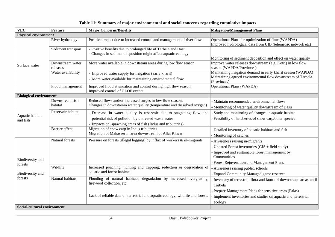
54 Dasu Hydropower Project
Table 11: Summary of major environmental and social concerns regarding cumulative impacts
VEC Feature Major Concerns/Benefits Mitigation/Management Plans
Physical environment
Surface water
River hydrology Positive impact due to increased control and management of river flow Operational Plans for optimization of flow (WAPDA)
Improved hydrological data from UIB (telemetric network etc)
Sediment transport - Positive benefits due to prolonged life of Tarbela and Dasu
- Changes in sediment deposition might affect aquatic ecology
Monitoring of sediment deposition and effect on water quality
Downstream water
releases
More water available in downstream areas during low flow season Improve water releases downstream (e.g. Kotri) in low flow
season (WAPDA/Provinces)
Water availability - Improved water supply for irrigation (early kharif)
- More water available for maintaining environmental flow
Maintaining irrigation demand in early kharif season (WAPDA)
Maintaining agreed environmental flow downstream of Tarbela
(Provinces)
Flood management Improved flood attenuation and control during high flow season
Improved control of GLOF events
Operational Plans (WAPDA)
Biological environment
Aquatic habitat
and fish
Downstream fish
habitat
Reduced flows and/or increased surges in low flow season;
Changes in downstream water quality (temperature and dissolved oxygen). - Maintain recommended environmental flows
- Monitoring of water quality downstream of Dasu
Reservoir habitat - Decrease in water quality is reservoir due to stagnating flow and
potential risk of pollution by untreated waste water
- Impacts on spawning areas of fish (Indus and tributaries)
- Study and monitoring of changes in aquatic habitat
- Feasibility of hatcheries of snow carp/other species
Barrier effect Migration of snow carp in Indus tributaries
Migration of Mahaseer in area downstream of Allai Khwar - Detailed inventory of aquatic habitats and fish
- Monitoring of catches
Biodiversity and
forests
Biodiversity and
forests
Natural forests Pressure on forests (illegal logging) by influx of workers & in-migrants - Awareness raising in-migrants
- Updated Forest inventories (GIS + field study)
- Improved and sustainable forest management by
Communities
- Forest Rejuvenation and Management Plans
Wildlife Increased poaching, hunting and trapping; reduction or degradation of
aquatic and forest habitats - Awareness raising public, schools
- Expand Community Managed game reserves
Natural habitats Flooding of natural habitats, degradation by increased overgrazing,
firewood collection, etc. - Inventory of terrestrial flora and fauna of downstream areas until
Tarbela
- Prepare Management Plans for sensitive areas (Palas)
Lack of reliable data on terrestrial and aquatic ecology, wildlife and forests - Implement inventories and studies on aquatic and terrestrial
ecology
Social/cultural environment

55 Dasu Hydropower Project
VEC Feature Major Concerns/Benefits Mitigation/Management Plans
PCR Archaeology Loss of more than 31,000 petroglyphs along “Silk Road” by inundation of
reservoir and/or vandalism from KKH travelers - Prepare a salvage and management plan in cooperation with
national and international archeologists
- Establish a museum for display and information
Social behavior Influx of migrants Lack of respect for cultural norms and traditions local population - Prepare Migration Management Plans
- Awareness raising and Grievance address mechanisms
KKH Access to area Frequent blockage and poor maintenance KKH Upgrade KKH to highway standards

56 Dasu Hydropower Project
9. Environmental and Social Management Plan
9.1. General
Various categories of mitigating measures: The ESMP includes various categories of mitigation measures
and plans: i) generic and non site-specific and project-specific measures in the form of environmental codes of
practices (ECPs) presented in Annex D of the main ESA; ii) project specific and to the extent possible, site-
specific mitigation measures discussed in Chapter 7; iii) site-specific and contract-specific management plans
to be prepared by various contractors; and iv) management plans already prepared during the detailed design
phase.
Inclusion of ESMP and SRMP in Contract Documents. In order to make contractors fully aware and
responsible of the implications of the EMP and SRMP to ensure compliance, it is recommended that
environmental measures will be included in the tender documentation. The contractor must be made
accountable through contract documents and/or other agreements of the obligations and importance of the
environmental and social components of the Project.
Payment milestones: would be linked to environmental, health and safety performance, measured by
completion of the prescribed environmental and social mitigation measures. Contractors would be trained how
to join forces with the executing agency, project management unit, supervising consultants and local
population for the mitigation of adverse impacts of the project. For effective implementation of the proposed
mitigation and monitoring measures they would attract trained and experienced environmental management
staff.
9.2. Environmental and Social Management
9.2.1. Environmental Codes of Practice
A set of environmental codes of practice (ECPs) have been prepared for various aspects of the environmental
and social management: ECP 1: Waste Management; ECP 2: Fuels and Hazardous Goods Management; ECP
3: Water Resources Management; ECP 4: Drainage Management; ECP 5: Soil Quality Management; ECP 6:
Erosion and Sediment Control; ECP 7: Top Soil Management; ECP 8: Topography and Landscaping; ECP 9:
Quarry Areas Development and Operation; ECP 10: Air Quality Management; ECP 11: Noise and Vibration
Management; ECP 12: Protection of Flora; ECP 13: Protection of Fauna; ECP 14: Protection of Fisheries;
ECP 15: Road Transport and Road Traffic Management; ECP 16: Construction Camp Management; ECP 17:
Cultural and Religious Issues; ECP 18: Workers Health and Safety; The contractors will be contractually
obligated to comply with these ECPs, presented in Annex D of main ESA.
9.2.2. Site-specific Plans
The following site-specific plans will be prepared by contractors to manage and mitigate/reverse potential
adverse environmental impacts:
Landscaping and Replanting Plan will be prepared by a qualified landscape architect to replace or
compensate the vegetation and trees lost during land acquisition and resettlement of villages, clearing of
construction sites and other areas needed for construction activities such as borrow and disposal areas,
batching plants, workshops and other facilities. Landscaping, restoration, and plantation methodologies will
be included in the Plan. Tree species to be selected would be natural or semi-natural, adapted to the local
(micro) climate and predominant soil conditions in the area. Establishment of one or more nurseries will be
considered as part of the Forestry Rejuvenation Plan for upland forest resources. The Plan would be approved
by the CSC and a landscape architect assigned by WAPDA.
Borrow Area Management and Restoration Plan for management and restoration of borrow areas will be
prepared by the Contractor on the basis of ECPs 8 and 9 (Annex D of main ESA) and other requirements
described in the mitigation plans (presented later in the Chapter). This Plan would aim at minimizing the
environmental and social impacts during borrowing activities and restoring as much as possible the original
natural situation of these sites by various measures (refill, leveling or smoothening) and removing all non-
natural artifacts such as equipment parts, and sheds. Restoration methodologies will be included in the Plan.
The Plan would be approved by the CSC and a landscape architect assigned by WAPDA.
Disposal Area Management and Restoration Plan for management and restoration of disposal areas will be
prepared by the Contractor on the basis of ECP 8 and other requirements described in the mitigation plans.

57 Dasu Hydropower Project
The Plan will describe the procedures for spoil management, transportation and disposal at the selected site(s).
The Plan will also describe the procedures for systematically disposing the spoil at the disposal site. This Plan
would aim at minimizing the environmental and social impacts during disposal activities and restoring as
much as possible the original natural situation of these sites by various measures (landscaping, leveling or
smoothening). The Plan will include measures to avoid land/soil erosion and landslides. Restoration
methodologies will be included in the Plan. The Plan would be approved by the CSC and a landscape architect
assigned by WAPDA.
Occupational Health and Safety (OHS) Plan will be prepared and implemented by each contractor on the
basis of the IFC/WBG EHS Guidelines (1997), ECP 18, and other relevant standards. The Plan will be
submitted to the CSC for their review and approval before contractor mobilization.
Pollution Prevention Plan will be prepared and implemented by the Contractor on the basis of the ECP 1,
ECP 2, ECP 11, and IFC/WBG EHS Guidelines (1997), as well as the mitigation plans given later in the
Chapter. The Plan will be submitted to the CSC for their review and approval before contractor mobilization.
Waste Disposal and Effluent Management Plan will be prepared and implemented by the Contractor on the
basis of the ECP 1, ECP 4, and IFC/WBG EHS Guidelines (1997), as well as the mitigation plans. The Plan
will be submitted to the CSC for their review and approval before contractor mobilization.
Drinking Water Supply and Sanitation Plan: Separate water supply and sanitation provisions will be
needed for the temporary facilities including offices, labor camps and workshops in order not to cause
shortages and/or contamination. A Plan will be prepared by the Contractor on basis of the ECP 3 and the
mitigation plans given later in the Chapter. The Plan will be submitted to the CSC for their review and
approval before contractor mobilization.
Traffic Management Plan (TMP) will be prepared by each contractor on the basis of ECP 15 and also the
mitigation plans given later in the Chapter after discussion with WAPDA and authorities responsible for roads
and traffic. The Plan will be submitted to the CSC/WEC for their review and approval before contractor
mobilization. CSC will facilitate the integration and coordination of these plans to prepare an overall TMP.
Construction Camp Management Plan: will be prepared by each contractor on the basis of ECP 16 and also
the mitigation plans given later in the Chapter. The Plan will include the camp layout, details of various
facilities including supplies, storage, and disposal. The Plan will be submitted to the CSC for their review and
approval before camp establishment.
Fuel and Hazardous Substances Management Plan will be prepared by each contractor on the basis of ECP
2 as well as the mitigation plans given later in the Chapter and in accordance with the standard operating
procedures, relevant guidelines, and where applicable, material safety data sheets (MSDS). The Plan will
include the procedures for handling the oils and chemical spills. The Plan will be submitted to the CSC for
their review and approval before contractor mobilization.
An Emergency Preparedness Plan will be prepared by each contractor after assessing potential risks and
hazards that could be encountered during construction. The Plan will be submitted to the CSC for their review
and approval before contractor mobilization.
Afforestation and Forest Rejuvenation Plan: The forest areas above 1,500 m amsl are already being
exploited in an unsustainable manner: harvesting only. It can be expected that this type of exploitation will
increase since it is one of the few potential sources of income for the increasing population, whereas the
project-induced move up mountain will result in additional stress on forest resources as well as on wildlife. In
order to maintain a healthy forest ecosystem, modern management will have to be introduced, including
planning of felling and rejuvenation (including nursery activities). Preparation of a Forestry Management
Program by forestry consultants and in cooperation with the Forestry Department is urgently required.
Implementation of such program would also create a relatively large number of jobs for forestry activities
proper (including a nursery) and for enforcement of regulations. The Plan needs to be finalized before the
commencement of main construction works. The Plan would include sustainable logging systems,
rejuvenation schedules, nursery, manpower implications (forestry staff, guards) and a sound financial system
to make the Plan self-sufficient. The ToRs of this Plan are presented in Annex B of main ESA.
Ecological Conservation Plan: Under this Plan, two wildlife conservation areas will be developed as offsets
to the potential impacts of the project on Kaigah Community Game Reserve. This will be done on the basis of
a thorough assessment and community engagements that will be carried out during the first year the preceding
study on forestry and wildlife management (ToRs included in main ESA volume). A mechanism will be
included in the Plan, whereby the local communities will be provided with appropriate incentives to help

58 Dasu Hydropower Project
conserve natural habitat, wildlife and forests. These conservation areas will be further complemented by
ecotourism initiatives, an information centre and research.
PCR Plan. Under this Plan, the mosque in Seer Gayal will be disassembled, transported and reassembled at a
higher altitude at the new location of the village, in consultation with the community. Also covered under the
Plan will be the activities required (land procurement, fencing, protection of carvings, and tourist facilities) for
the protection of rock carvings at Shatial. The Plan will also include archeological survey to be carried out by
an archeologist engaged by WAPDA before the commencement of construction activities in the project area to
identify any PCR sites/artifacts.
Fish Conservation and Management Plan. Under this Plan, specific measures will be identified and planned
for the conservation of the aquatic fauna, particularly fish. The key element of this Plan will be the
development of a snow carp hatchery with all the allied facilities for the primary objective of restocking the
Indus river upstream and downstream of the Dasu dam and also the tributaries (and also other Indus tributaries
where smaller hydropower plants are being established/planned). This Plan will be developed on the basis of
the aquatic (and terrestrial) baseline study (ToRs provided under the main ESA volume).
9.2.3. Social Management
Resettlement Action Plan (RAP): The Project will require acquire about 4,643 ha of land, affect a total of
767 households as a result of the construction dam and powerhouse, formation of the reservoir, and the
relocation of KKH. The social impacts largely include loss of residential and agricultural land, residential,
commercial and communal structures, as well as loss of income and livelihoods. To address and mitigate
these relocation and resettlement impacts, the RAP has been prepared under the SRMP.
Income and Livelihood Restoration Program: The income and livelihood restoration program (ILRP) has
been developed with the aim of improving or at the least restoring to the earlier level the livelihood of all
displaced households/persons. In preparing the program the impact of dislocation on livelihoods and adversely
affected income was given due consideration. In addition to income restoration, capacity building and
enhancing social capital of the affected communities are major objectives of the ILRP. Hence, training and
skills development and measures for income and livelihood restoration of those affected have been included in
addition to compensation and resettlement benefits. An approach in two phases has been selected. Phase I
(2014-2019) is a short-term program implemented during the construction of the main structure and the
relocation of the affected people. Phase II will start in 2019 will start after completion of the main structure.
The RAP has provisions for a Social Development Fund to finance a long-term (10 year) livelihood
development program. The detailed planning of livelihood activities will be carried out with participation of
the local community. The long-term programs will be designed considering the sustainability of income and
livelihood based on local resources, skills, and market opportunities.
Gender Action Plan: A gender assessment was conducted under the project. The assessment revealed the
lacking development status of women, analyzed the challenging environment and explored potential entry
points for gender interventions under the project. A Gender Action Plan was developed on the basis of this
assessment. The action plan recommends a three-prong approach. The first is to educate project staff,
including construction forces to raise awareness and increase sensitivity on gender. The second is to educate
men, such as maliks, religious leaders and husbands on the importance for women to access project benefits.
The third is to identify existing and future entry points and use them as much as possible to benefit women. It
is cautioned that, given the sensitivity, all interventions related to women will need to be discussed and agreed
with the communities first before putting to implementation
Communication and Information Plan: WAPDA has developed a communication strategy for different
target groups (local communities, previously affected persons, local and provincial authorities, general public
and press). During the project regular briefings of progress will be organized for public information and for
the media. The Communication and Information Centre will also have a section where complaints and
grievances can be registered and addressed. A Communication and Information Specialist will be appointed
for the project. WAPDA is engaging consultant experts to develop the Communication and Information Plan.
This plan is expected to be completed by end 2014.
Public Health Action Plan: A Public Health Action Plan has been prepared by the contractor on the basis of
an evaluation of the health situation and services in the area as well as the additional requirements of health
services in terms of quality and extent during project construction. The Plan will be submitted to the
environmental monitoring team/WEC for their review and approval. Also the increased safety risk for workers
and public are during construction has to be considered. The objective of the plan is to minimize the risks and

59 Dasu Hydropower Project
possible harmful effects on health due to construction activities. The plan is scheduled for a period of seven
years. In the beginning of the construction phase an information and prevention program will be carried out
aimed at the resident population in the project area who will interact with the expected influx of workers
during construction. The plan will furthermore focus on keeping the construction workforce safe from
occupational hazards and health risks from living together in compounds. The workforce would have easy
access to clinical care in order to minimize adverse effects and health risks. A medical facility will be set up
for the construction workers. The facilities must also have the capacity to treat emergency cases and referral
point for sexually transmitting diseases.
Migration Management Plan: This plan outlines the approach and steps to be taken by WAPDA during
construction and operation periods to manage the impacts of the influx of large numbers of migrants by
implementing various plans as described elsewhere in the report. The objective of the plan is to avoid and
mitigate potential adverse impacts of influx of construction workers and other in-migrants on the local
communities and the project-affected persons. The plan will also address the social dynamics between the
different communities and groups and strengthen inter-cultural understanding. Finally it will help to build an
integrated vibrant local community to facilitate better project management and implementation of the project.
9.3. Overview of Impacts and Mitigating Measures
An overview of all impacts and mitigating measures, including responsibilities and monitoring requirements is
given in Table 12 (next page).

60 Dasu Hydropower Project
Table 12: Overview of Impacts and Mitigation
IMPACTS/ISSUES MITIGATION MEASURES TIME
FRAME
COST IN US$
x 106
RESPONSIBILITY MONITORING
INDICATORS
MONITORING
FREQUENCY Implement Supervision
DASU HYDROPOWER PROJECT (overall impacts)
1 Installation of 1,080 MW hydropower
plant in phased development expanded
to 4,320 MW at final stage through a
run-of-river structure with minimal
environmental and relatively low
social challenges
Desirable outcome of project 2020 and after
Total of 3,650
Contractor WAPDA Power generated
Monthly
2 Expansion of Pakistan electricity
generation with minimal Carbon
emission
Desirable outcome of project 2020 and after WAPDA GoP % hydropower of total
power production
Annually
3 Stimulation of socio-economic
development of one of the least
developed districts of Pakistan
Creating structures and
preconditions for further
development of the district
From
2015onwards p.m.
Civil
administration
GoP Socio-economic
development
indicators
Annually
A1- ENVIRONMENTAL IMPACTS DUE TO PROJECT SITING
1 Change in land use and acquisition of
land needed for reservoir, physical
project infrastructure and construction
will require the acquisition of 4,643 ha
of land, including 425 ha of
agricultural land
Compensation for land
acquisition paid to the affectees
(767 households);
Temporary leasing of land
needed for batching plant,
construction workshops, labor
camps and borrow areas
2014- 15
In RAP budget
PMU WAPDA Land acquired Monthly until start
of construction
2 Loss of natural vegetation and cutting
of some 21,000 trees
- Replanting of 105,00 trees
near resettlement sites and
along roads
- Promote alternatives for fuel
wood
2014- 19
In EMP budget
WAPDA Forest Dept - Nr of trees planted
- Nr of trees survived
Annually
3 Inundation of a 400 year old historic
mosque in Seer Gayal
Dismantling of wooden
structure and rebuilding at
higher
2020
In EMP budget
Contractor Local community,
Archeology Dept.
Mosque rebuilt
4 Impacts of increased traffic and
transportation (congestion, noise, air)
on city of Dasu and along KKH
Prepare Traffic Management
Plan and plan for by-pass road
Dasu
2015-2022 In budget
contractor
Contractor - PMU
- Local authority
Plan prepared
At start of
construction
5 Inundation of 52 km of KKH - Realignment of 62 km of
KKH to higher level above
reservoir
2014-16 KKH-1
39,600
Contractor PMU km of road rebuilt Half yearly

61 Dasu Hydropower Project
IMPACTS/ISSUES MITIGATION MEASURES TIME
FRAME
COST IN US$
x 106
RESPONSIBILITY MONITORING
INDICATORS
MONITORING
FREQUENCY Implement Supervision
- Construction of 13 km access
road from Komila to dam site
KKH-2
110,000
6 Loss of 2 suspension bridges and 3
other bridges, 5 footbridges and
several cable cars
Rebuild bridge on Indus and
develop access road all along
the right bank
2014-16 In budget
contractor
Contractor PMU - Number of
bridges/river
crossings rebuilt
Half yearly
7 Loss of 25 km of secondary access
roads at right bank and other jeepable
roads
Construct access roads on right
bank of river at higher level
giving access to side valleys
and resettlement sites
2015-2016
In budget
contractor
Contractor PMU - km of access roads
built;
- Number of
resettlement sites
connected.
Half yearly
8 Impacts on Kaigah Community-
managed Game Reserve
Development of new
conservation areas
Compensation of lost income
due to hunting
2014- 19
In EMP budget
PMU Wildlife Dept in
cooperation with
WWF
- Number of hunting
permits sold
- Number of markhor
sighted
Yearly
A2 - SOCIAL IMPACTS DUE TO PROJECT SITING
1 Land Acquisition for project (4,643
ha)
Compensation and/or
resettlement according to
entitlement matrix/RAP
2014-15
In RAP budget
PMU WAPDA Land acquired Monthly
2 Relocation of households from 34
villages
Compensation and/or
resettlement according to
entitlement matrix/RAP
2014-15
In RAP budget
PMU WAPDA Number of households
compensated and/or
resettled
Monthly
3 Relocation of shops/commercial
establishments.
Compensation and/or
resettlement according to
entitlement matrix/RAP
2014-15 In RAP budget PMU WAPDA Number of businesses
compensated
Monthly
4 Loss of various civic amenities, 31
mosques, 7 schools, 1 motel, 2 basic
health units.
Rebuilding of civic amenities in
resettlement areas
2014-15 In RAP budget PMU/DCO WAPDA Number of civic
amenities, sites and
services rebuild
Monthly
5 Loss of 423 ha of farmland, grazing
area and crops
- Livelihood restoration;
- Agriculture, Livestock and
Fisheries Development
Program
2014-15
In RAP budget
PMU/DCO WAPDA Social development
indicators
Annually
6 Increased pressure on high/altitude
grazing areas and forests
- Forestry and Wildlife
Management Study
- Implement Forest
Rejuvenation Plan
2015 and after
In EMP budget
WWF/Forest
Dept/ Wildlife
Dept
WAPDA - Study implemented
- Update Forest
Assessment (GIS)
- Hectares of forest
planted/rejuvenated
Every 5 year
7 Impacts of construction of 132 kV Compensation of owners of 2014-2015

62 Dasu Hydropower Project
IMPACTS/ISSUES MITIGATION MEASURES TIME
FRAME
COST IN US$
x 106
RESPONSIBILITY MONITORING
INDICATORS
MONITORING
FREQUENCY Implement Supervision
power supply line for Project and
Colony
land;
Avoiding residential and
agricultural areas and dense
forest
Reduction of health hazards
for community and workers
8 Generation of employment in region - Contractor attract local
workers and technicians on
basis of quota;
- Development of fisheries in
reservoir
- Livelihood restoration;
- Vocational training for local
workers.
2015-22 Contractor PMU Number of employed
workers from region
Annually
9 Increased activity in the project area
will stimulate local economy
Indirect positive impact Social development
indicators
Annually
B1 - CONSTRUCTION STAGE: CONSTRUCTION-RELATED ENVIRONMENTAL IMPACTS
1 Increased traffic on KKH and local
access roads due to project related
vehicles, also from borrow areas.
Implement Traffic Management
Plan, provide by-passes, take
safety measures and repair
damage
2015-2022 In budget
contractor
Contractor PMU - Road status reports
- Number of
complaints
Permanent
2 Impact on river habitat during
construction and loss of aquatic life
between two coffer dams (temporarily)
at the footprints of the dam
(permanently)
- Study on significance of fish
and monitoring
- Implementation of ECPs
2015-20 In budget EMP Fisheries
consultant
Contractor
Environment and
Social Unit (ESMU) -
DHP
- Study results
published
- Environmental flow
maintained
Annually
3 Mortality of fish during downstream
movement on spillway, intakes and
inlets of hydraulic structures
Prevent fish passage by
acoustic deterrent methods
2015-20 In budget
fisheries
contractor
Contractor ESMU - DHP,
Construction
Supervision
Consultants (CSC)
- Number of screens
placed
- Amount of
restocking needed
Annually
4 Potential risk of pollution of air, noise,
soil, surface water and groundwater
from construction areas, yards,
batching plants, quarry areas, worker
camps and residential areas
- Prepare Pollution Prevention
Plan;
- Establish base line data
- Implement measures
prescribed in ECP
2015-22 In budget
contractor
Contractor ESMU-DHP, CSC Usual chemical and
bacteriological water
quality parameters
Permanent
5 Pollution through solid waste and
waste effluents from field camps and
- Waste Management and
Effluent Management Plan;
2015-22 In budget
contractor
Contractor ESMU-DHP, CSC - Plan ready and
accepted;
Permanent

63 Dasu Hydropower Project
IMPACTS/ISSUES MITIGATION MEASURES TIME
FRAME
COST IN US$
x 106
RESPONSIBILITY MONITORING
INDICATORS
MONITORING
FREQUENCY Implement Supervision
construction yards - Protocols and measures
prescribed in ECP
- Solid waste
- Monitoring reports
6 Potential loss of land by deposition of
excess rock material
- Reduction of excavated rock
material through re-use of
material in construction works
- Re-use plan for disposal areas
2015-22 In budget
contractor
Contractor ESMU-DHP, CSC Area of arable land
lost
7 Impact from quarry activities Implementation of ECPS
Plan for Restoration of quarry
Areas
2015-2019 In budget
contractor
Contractor ESMU-DHP, CSC - Monitoring reports;
- Percentage of plan
implemented
Quarterly
8 Impacts of noise and dust from
construction and use of explosives on
residential areas and workers
- No blasting and drilling
during night time;
- Continued consultations with
communities
2015-20 In budget
contractor
Contractor ESMU-DHP, CSC - Noise levels
- Number of
complaints
Permanent
9 Increased risk of landslides and
collapse of slope (use of explosives,
heavy rainfall) during construction
Pro-active measures to stabilize
and protect slopes and to
protect workers safety
2015-19 In budget
contractor
Contractor PMU Visual inspections Permanent
10 Impacts from increased human
activities on flora and fauna
- Code of conduct for workers
and employees
- Awareness raising
2015-22 In budget
contractor
Contractor ESMU-DHP, Forest
& Wildlife
Departments
- Number of incidents
reported
- Monitoring reports
Quarterly
11 Risk of water pollution in area that
will be submerged
- Removal of oil tanks and
storage facilities of chemicals
and other products
2015-20 In budget
contractor
Contractor ESMU-DHP, CSC Plan prepared At start of
construction
12 Shortages and/or negative effects on
local water supply and sanitation
Prepare Drinking Water Supply
and Sanitation Plan based on
separate water supply and
sanitation for work force
2015-22 In budget
contractor
Contractor ESMU-DHP, CSC - Plan ready and
accepted;
- Number of
complaints
Permanent
13 Impacts of emissions of gasses and
dust on air quality due to earth moving
activities, vehicle and generators
emissions
Protocols and measures
prescribed in ECP
Permanent monitoring
2015-19 In budget
contractor
Contractor ESMU-DHP, CSC -air quality
- monitoring reports
Permanent
14 Impact on the ecological connectivity
and composition of the aquatic fauna
and migration of fish in Indus and
tributaries between Raikot bridge and
Tarbela
- Implement aquatic and
terrestrial ecology baseline
study
- Monitoring of changes and
recommendations for
environmental flow
2014 - 15 In EMP budget Ecological
NGO in
cooperation
with Consultant
or University
ESMU-DHP, CSC - Monitor ecological
parameters aquatic
and terrestrial fauna
Seasonally
15 Disturbance of visual landscape and - Landscaping plan 2015-22 In EMP budget Contractor in ESMU-DHP, CSC - Acreage nurseries Seasonally

64 Dasu Hydropower Project
IMPACTS/ISSUES MITIGATION MEASURES TIME
FRAME
COST IN US$
x 106
RESPONSIBILITY MONITORING
INDICATORS
MONITORING
FREQUENCY Implement Supervision
natural habitats - Establishing nurseries
- Plantation of trees
cooperation
with Forestry
Dept
- Number of trees
planted
B2 – CONSTRUCTION STAGE: - CONSTRUCTION-RELATED SOCIAL IMPACTS
1. Safety hazards and reduced mobility
due to increased traffic especially for
women, children and elderly people.
- Implement Traffic
Management Plan;
- Recruitment of trained
drivers;
- Adequate facilities for
emergencies
2015-22
In budget
contractor
Contractor local health services - Plan ready and
accepted
- Number of accidents
- Number of incidents
Permanent
2. Social unrest due to influx of about
5,000 immigrant construction workers,
technicians and other staff and their
families
- Awareness campaign;
- Implement Migration
Management Plan
- Grievance mechanisms to
address complaints from
local community and
immigrants
2015-22 In SRMP
budget
Contractor WAPDA/DCO/local
leaders
Number of complaints
Permanent
3. Lack of respect for cultural norms and
values by workers coming from
different parts of the country
- Awareness campaign;
- Code of conduct for workers
- Grievance mechanism to
address complaints from
local community
2015-22 In SRMP
budget
Contractor/PMU
WAPDA/DCO/local
leaders
Number of complaints Permanent
4. Reduced safety and adverse effects on
health situation by interaction of
construction workforce with local
residents, including spread of
infectious diseases (hepatitis,
HIV/AIDS)
- Implement Public Health and
Safety Plan;
- Safeguards and awareness
raising against communicable
diseases;
- Gender Action Plan
2015-22 In SRMP
budget
DoH/WAPDA - Plans prepared and
accepted
- Incidence of
infectious diseases
- Health indicators
5. Increased load on local services and
supplies (markets, service providers,
and others),
Contractor to procure the
supplies in a manner not to
significantly affect the
availability of essential
commodities in the area.
2015-22 In budget
contractor
Contractor WAPDA Permanent
6. Increased risk of accidents, unsafe
working conditions and health risks
for workforce
- Emergency Preparedness
Plan;
- Contractor follows IFC
Performance Standards on
2015-22 In budget
contractor
Contractor WAPDA Plan prepared and
accepted
Permanent

65 Dasu Hydropower Project
IMPACTS/ISSUES MITIGATION MEASURES TIME
FRAME
COST IN US$
x 106
RESPONSIBILITY MONITORING
INDICATORS
MONITORING
FREQUENCY Implement Supervision
Labor and Working
Conditions;
- Safety training for workers
C1 – OPERATION AND MAINTENANCE STAGE: ENVIRONMENTAL IMPACTS
1 Adverse impacts on aquatic fauna
downstream of the dam site
Maintain environmental flow in
low flood season
2020 and after In EMP budget Aquatic
ecologist,
Fishery Dept
ESMU-DHP, CSC - Aquatic biota
observed;
- Trial catches of fish
Seasonally
2 Impacts of first filling of the reservoir
on safety of people and livestock and
the stability of valley slopes.
- Awareness campaign to
inform local population;
- Slow rate of filling to prevent
collapse of slopes
2020 In EMP budget WAPDA ESMU-DHP, CSC - Number of
incidents
- Rise in water level
per day
Permanent
3 Impact of sedimentation on reservoir
area
Yearly flushing after 10- 15
years operation
2020 and after WAPDA ESMU-DHP, CSC Monthly
4 Impact of flushing on downstream
fisheries of reservoir on fish
production during base-load
operations
Fisheries management plan
including restocking
With the start
of flushing
and after
Fisheries
Contractor
WAPDA - Fish catches
- Percentage of
losses
Permanent
5 Impact of daily reservoir operation on
downstream hydrology during peaking
production
- Continuous operation of one
turbine
after Basha WAPDA ESMU-DHP, CSC Monitoring of
downstream flows
Permanent
6 Increased human activities at higher
altitudes will increase the pressure on
forests and wildlife
Rejuvenation of high altitude
forests and livelihood
restoration concentrated on the
reservoir area and the lateral
valleys
2015 and after Environ-
mental Fund
Dept. of
Forestry &
Dept. of
Wildlife
ESMU-DHP, CSC - Number of
incidents with
illegal logging
poaching, hunting.
- Livelihood
development
Permanent
7 Risk of bird collisions with
transmission cables
Design of lines with 1.5 m
spacing; Provide markers, bird
deterrents in transmission
cables
2020 and after In budget
NTDC
NTDC Number of fatalities
recorded
Weekly during
migration
C2 – OPERATION AND MAINTENANCE STAGE: SOCIAL IMPACTS
1 Loss of employment for construction
workers
Implement Social Assistance
Program, including vocational
training
2022 and after PMU WAPDA, CSC
2 Efficient use of reservoir fisheries will
create employment opportunities
Fisheries Management plan 2020 and after Fisheries
contractor
WAPDA - Nr of jobs+
- Fish production

66 Dasu Hydropower Project
9.4. Monitoring Plan
The monitoring program has a dual purpose. It is designed (i) to monitor the contractor’s work during project
implementation in order to check contractual compliance with specified mitigation measures, and
subsequently (ii) to assess the actual environmental and social impacts of the project over the years following
completion of the various project components. The first type of monitoring will be carried out by the
Engineering Consultant and supervised by an independent environmental management consultant. The second
type of monitoring will be commissioned and carried out by a local organization or consultant with sufficient
experience in environmental, ecological and social monitoring. The total cost of monitoring has been
estimated at US$ 0.50 m. Monitoring indicators and frequency are shown in Table 13.
Table 13: Effects Monitoring Plan
Parameter Means of Monitoring Frequency Responsible Agency
Implementation Supervision
During Construction
Landslides Visual Inspection on stability of
landslide areas
Monthly Contractor CSC, DHP
Top Soil Visual inspection on stripping, storage
and reuse of top soil
Monthly Contractor EU-CSC, EU-
DHP
Erosion Visual inspection of erosion prevention
measures and occurrence of erosion
Monthly Contractor EU-CSC, EU-
DHP
Operation of quarry
sites
Visual inspection of quarry sites Monthly Contractor EU-CSC, EU-
DHP
Surface water
quality
Sampling and analysis of river water
quality and waste water discharges for
the parameters given in NEQS 2000
Quarterly
Contractor EU-CSC, EU-
DHP
Annually
External Monitor (DHP
through a nationally
recognized Laboratory)
EU-CSC, EU-
DHP
Spot measurements of pH,
conductivity, turbidity. Visual
inspection on presence of petroleum
products.
Monthly EU-CSC EU-CSC, EU-
DHP
Air Quality (dust,
smoke)
Visual inspection to ensure good
standard equipment is in use and dust
suppression measures (spraying of
waters) are in place.
Weekly Contractor EU-CSC, EU-
DHP
Visual inspection to ensure dust
suppression work plan is being
implemented
Weekly Contractor EU EU-CSC, EU-
DHP
Air Quality in
tunnels
Spot measurements for CO and O2
levels in the tunnels
Monthly EU-CSC EU-DHP
Air Quality (PM10,
NO2, SO2, CO2,
CO)
Air quality monitoring for 24 hours for
the parameters specified in NEQS
2000
Quarterly Contractor EU-CSC, EU-
DHP
Annually External Monitor (DHP
through a nationally
recognized laboratory)
EU-CSC, EU-
DHP
Emissions from
plant and equipment
Visual Inspection Monthly Contractor EU-CSC, EU-
DHP
Noise and vibration 24 hour noise monitoring
Quarterly Contractor EU-CSC, EU-
DHP

67 Dasu Hydropower Project
Parameter Means of Monitoring Frequency Responsible Agency
Implementation Supervision
24 hour noise monitoring Annually External Monitor (DHP
through a nationally
recognized laboratory)
EU-CSC, EU-
DHP
Spot measurements Monthly CSC EU-DHP
Waste Management Visual inspection on spoil disposal in
accordance with EMP Sub plan on
Waste Management
Monthly Contractor EU-CSC, EU-
DHP
Visual inspection that solid waste is
disposed at designated sites
Monthly Contractor EU-CSC, EU-
DHP
Spills from
hydrocarbon and
chemical storage
Visual Inspection for leaks and spills Monthly Contractor EU-CSC, EU-
DHP
Wild life (including
migratory bird)
Surveys for wildlife and migratory
birds in accordance with EMP Sub-
Plan on Terrestrial and Ecology
Management
Half yearly DHP through nationally
recognized institute
EU-CSC, EU-
DHP
Ensure the adherence of the migratory
measures proposed in the EMP
Monthly DHP through nationally
recognized institute
EU-CSC, EU-
DHP
Fish Surveys for fish in accordance with
EMP Sub-Plan on Aquatic Ecology
Management
Half yearly DHP through nationally
recognized institute
EU-CSC, EU-
DHP, External
Monitor
Traffic Safety Visual inspection to see whether
Traffic Management Plan (EMP Sub
Plan 12) is implemented
Monthly Contractor EU-CSC, EU-
DHP,
Local Roads Visual inspection to ensure local roads
are not damaged
Monthly Contractor EU-CSC, EU-
DHP,
Cultural and
archeological Sites
Visual observation on implementation
of EMP Sub Plan 13 on Physical
Cultural Resources Management
Monthly Contractor EU-CSC, EU-
DHP,, External
Monitor
Drinking water and
sanitation
Ensure the construction workers are
provided with safe water and sanitation
facilities in the site
Weekly Contractor EU-CSC, EU-
DHP,
Safety of workers Usage of Personal Protective
equipment
Monthly Contractor EU-CSC, EU-
DHP,
Reinstatement of
Work Sites
Visual Inspection After
completion of
all works
Contractor EU-CSC, EU-
DHP,
Plantation Visual inspection to ensure plantations
are growing well.
Monthly District Forest Office with
support of civil society
EU-CSC, EU-
DHP,, External
Monitor
During Operation
Surface Water
Quality
Sampling and analysis for sediment
load, DO and temperature
Half Yearly DHP through nationally
recognized laboratory
CSC, External
Monitor
In situ measurements on DO and
Temperature at different depths in the
reservoir
Quarterly DHP through nationally
recognized laboratory
CSC, External
Monitor
Aquatic biota and
fish
Collection of information on presence,
seasonal behaviour and biotope
characteristics of selected species at
selected locations
Seasonally DHP through qualified
fishery expert together with
aquatic biologist
External Monitor
Downstream river
flows
Measurements of discharges to the
downstream
Monthly DHP External Monitor

68 Dasu Hydropower Project
Parameter Means of Monitoring Frequency Responsible Agency
Implementation Supervision
Migratory birds Surveys for migratory birds in
accordance with EMP Sub-Plan on
Terrestrial and Ecology Management
Half Yearly DHP through nationally
recognized institute
EU-DHP,
External Monitor
Fish Surveys for fish in accordance with
EMP Sub-Plan on Aquatic Ecology
Management
Half yearly DHP through nationally
recognized institute
EU-DHP,
External Monitor
Monthly data on fish catches Monthly Fisheries Contractor EU-DHP,
Dam Safety Monitoring of data from dam safety
equipment
Quarterly DHP Dam Safety
Organization of
WAPDA
Survey, inspection and testing Yearly Dam Safety Organization of
WAPDA
DHP
Survey, inspection and testing Once in three
years
External Monitor (DHP
through an internationally
recognized institute)
DHP
The role of WAPDA is to select consultants, NGOs and organizations needed for implementing the EMP and
the SRMP They will supervise progress and quality of EMP and SRMP and take over regular monitoring
activities during O&M phase. Result of monitoring of impacts will have to be reviewed and evaluated from
time to time by the M&E consultants. Findings might be used to revise the operational rules of the project.
Third Party Monitoring: WAPDA will engage qualified consultants to conduct third party monitoring on an
annual basis. The purpose of this monitoring will be to carry out an independent assessment and validation of
the EMP and SRMP implementation.
9.5. Institutional Aspects
The overall responsibility for the implementation of the project rests with the Project Management Unit
(PMU). Within the PMU there will be an Environment and Social Management Unit (ESMU), responsible for
implementing the EMP and the SRMP. The ESMU will include representatives of all actors responsible for
EMP/SRMP implementation. The responsibilities of the ESMU are: (i) supervision, facilitation and
coordination of environmental and social measures; (ii) ensure that contractors follow PEPA regulations and
other requirements mentioned in the EMP; (iii) identify any issues of non-compliance and report these; (iv)
suggest mechanisms to link contractor performance in relation to the EMP to the timing of financial payments,
incentives or penalties; (v) interaction with stakeholders for their concerns about the construction activities;
and (vi) implementation of contingency plans.
The ESMU will ultimately be responsible to the WEC, stationed in Lahore. It is proposed that WEC takes a
leading role in the ESMU by charging a senior WEC representative with overall responsibility for ESMU
during the construction phase. The potential for institutional strengthening and capacity building of WEC has
been identified. Currently WEC is understaffed. WEC operating at proposed sanctioned strength would be
adequately resourced to deliver the commitments set out in this EMP and SRMP. The head of the ESMU unit
reports directly to the Director PMU.
Composition of ESMU: The proposed composition of the ESMU team is as follows: (i) a Senior Engineer
level WAPDA officer with environmental science background; (ii) an HSE Specialist to be appointed by
WAPDA; (iii) a Social Scientist to be appointed by WAPDA; (iv) an Environmental and Social Monitor to be
appointed by the Design/Supervising Consultant; and (v) an Environmental and Social Supervisor to be
appointed by the Contractor.
Environmental and Social Management Unit: The task of the ESMU is to support and supervise the
Engineering Consultants responsible for daily supervision of the Construction operations in environmental
management and quality control. The ESMU is also responsible for supervising the preparation of the Health
and Safety Plan, and other social plans, such as the Emergency preparedness Plan, the Waste Management and
Effluent Management Plan, the Drinking Water and Sanitation Plan, the Information and Communication
Strategy and for addressing the Social Legacy issues.

69 Dasu Hydropower Project
Construction Supervision Consultants: The Construction Supervision Consultants will appoint dedicated
Environment and Social Supervisor(s) (ESS), to ensure the EMP and SRMP implementation during the
project. ESS will supervise the contractor for the EMP implementation, particularly the mitigation measures.
S/he will also be responsible for implementing the monitoring of effects of these measures.
Contractor: The contractor will be required to appoint a dedicated Environment/Social Officer(s) at the site
for the implementation of EMP in the field, particularly the mitigation measures. The contractor will also be
responsible for communicating with and training of its staff in the environmental/social aspects. The
contractor will develop the various plans directed towards health, safety, the environment and social issues,
and get them approved by the Supervision Consultants before the commencement of the physical works on
site. The construction contract will have appropriate clauses to bind the contractor for the above obligations.
9.6. Capacity Building and Training
Capacity building will be aimed at strengthening the WAPDA organization in Dasu in the field of
environmental management and social development. Members of the environmental/social unit responsible
for supervision of environmental and social mitigation measures would be trained in environmental
management, environmental quality control, ecology, environmental awareness, participatory approach and
social development. Training would not be restricted to WAPDA staff, but selected project staff involved in
construction and operation of the project would also be trained. The contractor will also be required to impart
environmental and social trainings to its staff, to ensure effective implementation of the EMP and SRMP. A
budget of US$ 0.6 million has been earmarked for capacity building and training. In addition to the project-
specific capacity building described above, WEC will be strengthened to actively partake in the environmental
and social management of the WAPDA projects, particularly towards the effective ESMP implementation of
the DHP, as well as the ESA studies and EMP and SRMP implementation of the forthcoming hydropower
projects such as the Basha dam. Additional funds of US$ 0.3 million have been allocated to establish a
GIS/MIS facility and for institutional strengthening of WEC.
9.7. Panel of Experts
WAPDA has engaged an independent panel of international environment and social experts to advise ESMU
and other project entities on all environmental and social matters including effective implementation of EMP
and SRMP, particularly on unanticipated situations, impacts, and their mitigation. The Panel has started work
and has so far implemented three missions to Pakistan. They had discussions with WAPDA and design
consultants, carried out field visits and reviewed various reports and documents. During the preparation and
construction period they will continue to convene on a regular basis. They will review reports produced by the
EMU, Supervision Consultants and contractors; periodically visit the site to have first-hand information on the
environmental and social impacts and EMP/SRMP implementation; and provide report to WAPDA on the
overall environmental and social performance of the project. An amount of US$ 0.43 million has been
included in the Project cost for this purpose.
9.8. Audits
Internal Environmental Audits will be held once during construction phase and once at the end of the
construction activities. The objective of the audits is to review the effectiveness of environmental
management. It is proposed that WEC would carry out these audits on six-monthly basis. External audits on
the implementation of the EMP and SRMP will be made by an independent industrial environmental
management specialist on an annual basis. These audits would be used to re-examine the continued
appropriateness of the EMP and SRMP and to provide advice on any up-dates required.
9.9. Reporting and Grievances
Reporting: Proper arrangements are necessary for recording, disseminating and responding to information
which emerges from the various environmental monitoring and management programs. They are also
necessary for rendering the environmental management system “auditable”. However, the primary focus must
remain on the pragmatic control of impacts, not the creation of complex bureaucratic procedures.
Grievances: Grievances are actual or perceived problems that might give grounds for complaints. As a
general policy, WAPDA will work proactively towards preventing grievances through the implementation of
impact mitigation measures and community liaison activities that anticipate and address potential issues
before they become grievances. Grievances recorded will be reviewed and investigated by Project staff and
outside authorities as appropriate. The investigations will aim to identify whether the incident leading to the
grievance is a singular occurrence or likely to reoccur. Possible remedial measures or actions will be identified

70 Dasu Hydropower Project
and implemented when justified. The responsibility for addressing grievances will rest with a committee
including Project Manager, the Contractor’s Site Manager and a person designated to be responsible for
stakeholder liaison.
9.10. Cost of EMP and SRMP
The cost of implementing EMP is shown in Table 14.
Table 14: EMP Implementation Cost Estimates
Description Estimated Cost
in (million US$)
Implementation of EMP by contractor 18.32
Environment staff in CSC 4.33
Environment staff in PMU 2.18
Internal auditing 0.20
External monitoring 0.50
Panel of experts 0.43
Capacity building, institutional strengthening 0.90
Monitoring of water and waste water quality 0.54
Spot monitoring of air, noise and water quality 0.44
Traffic management 1.54
Aquatic ecology and development of fisheries 6.22
Terrestrial ecology, forestry and nature conservation 6.75
Environmental management and enhancement of resettlement villages 2.10
Physical cultural resources 1.74
Provisional budget for implementation of additional offset measures,
including those for 500 kV transmission line, if required
7.0
Weather station in Colony 0.15
Glacier, Flood warning, climate change, watershed management 10.50
Total 63.84
A summary of the cost of implementing the RAP is given in Table 15.
Table 15: Cost of implementing RAP
Expenditure Item Total PKR
(Million)
Total US$
(Million)
1. Compensation & Allowances
a Land acquisition 17,122 180.2
b Structures 2,310 24.3
c Standing crops 64 0.7
d Trees 536 5.6
e Relocation cost 89 0.9
f Rehabilitation assistance 15 0.1
Sub total compensation & allowances 20,136 211.9
2 Resettlement sites development 1,585 16.7
3 Livelihood support 1,500 15.8
4 Local area development 2,850 30.0

71 Dasu Hydropower Project
Expenditure Item Total PKR
(Million)
Total US$
(Million)
5 Institution & Management 831 8.8
6 Planning and design 485 5.1
7 Administrative overheads 10 0.1
8 Monitoring & Evaluation 330 3.5
9 Training & Capacity Building 542 5.7
10 Contingencies (Physical and price) 9,611 101.2
Total Cost RAP 37,881 398.7
10. Stakeholder Consultations and Disclosure
10.1. Overview
Extensive consultations were carried out during the detailed design phase of the project, primarily through
community consultations, jirgas and stakeholder consultation workshops. Community consultations involved
multiple methods – for example, household level interviews, participatory rural appraisal (PRA), community
meetings, and focus group discussions (FGD). Given the cultural context, key issues were largely addressed
by community elders at jirga meetings. In some sense, standard participatory tools such as PRA and FGD and
small group meetings are constrained by the tribal political and decision-making systems. Therefore, jirga
meetings are the predominant modes for disclosure and decision-making in the project area.
A total of 2,392 persons were involved in various consultation meetings at the project sites and consultation
workshops (Table 16) between April 2012 and October 2012.
Table 16: Number of persons covered in various Consultation Meetings
Activities No. of participants
1. Social environmental surveys and inventory survey 1,435
2. Jirga meetings, consultation meetings 718
3. National consultative workshops 239
Total 2,392
10.2. Community Consultations
The main issues discussed with affected persons and communities are listed in Table 17 and how these issues
are addressed and incorporated is also shown in this table.
Table 17: Key issues raised in community consultations
Issues Description Action Point
Compensation for
land and other
assets
The compensation issues and rates are of importance both to
affected persons (APs) and WAPDA. The local demands have
been for the rate applied in the case of Basha Diamer Dam
upstream. Land acquisition (LA) notification has not been set yet
by Dasu District Revenue Officer (DRO). In view of the absence
of cadastral surveys/maps, it is important to prepare the maps and
records first with community and jirgas inputs. However, the
affected communities want WAPDA to fix the rate prior to
Section 4 notification. A recent jirga formed a committee to
discuss this with WAPDA Project Office.
Resettlement Site
development
Affected communities want to relocate to higher elevations, to
sites of their own choosing in the hills with basic amenities to be
built at project costs. People expressed their concerns regarding
access roads to new sites at upper elevations, water, power and
irrigation systems for terrace cultivation.
Resettlement sites will be developed
with all basic amenities and access
roads. Provisions for land
development for terrace cultivation
and irrigation are included in the
resettlement sites design.

72 Dasu Hydropower Project
Issues Description Action Point
Job and
Employment
The affected communities/sub-tribes demand full employment in
the project during construction and in post-construction periods.
In one of the jirga meetings, a request was made for vocational
schools for boys and girls to prepare the affected persons for
employment in the project. Accordingly, In addition, some
outside employment or overseas employment opportunities are
also expected by local APs.
WAPDA has also taken initiatives
to conduct pilot training for
candidates selected in batches from
project affected households.
Livelihoods The traditional terrace cultivation by the sub-tribes will be
affected due to relocation and lack of terraced land in upper
elevations. Thus, alternative livelihood after relocation must be
explored since the vocational training mainly focuses on the
limited scope of APs, namely, youth with at least completed
primary education.
A long term livelihood restoration
plan is developed.
Environmental and
Social Issues
Despite community-based preferred relocation, it will bring some
disruptions- for example schooling, access to market and health
clinic. Two suggestions were made at meetings: (i) reforestation
as an alternative livelihood after relocation, and (ii) the agro-
ecosystem of the affected area and need for new irrigation
support.
A long term livelihood restoration
plan is developed.
Health and safety
issues
The health and safety issues during dam construction were
discussed. Local people are concerned about migrant workers for
dam construction, noise and air quality issues, and heavy traffic
on KKH during the construction period. It was claimed that the
dam will affect community health and well-being and will impact
on their limited and fragile social infrastructure.
An EMP sub plan on Traffic
Management is prepared.
In-migrants and
Outsiders
This has been flagged in the community level meeting as a very
big concern by the affected communities. The “outsiders” – for
example, construction workers, construction material suppliers
and service providers (such as chefs, grocers, barbers, etc.) are
required, in addition to local human resources. However, local
villagers have “mixed” feeling about the outsiders moving in to
work, including potential cultural and social conflict.
A plan on In-migrant Management
is prepared.
10.3. Consultation Workshops
A summary of comments and suggestions received in the consultation workshops is given in Table 18.
Table 18: Summary of Discussions in Consultation Workshops
Comments and suggestions Action Point/Response
Development of an agricultural terrace in the hilly
areas will take several years of effort and hard
work. Development of agricultural terraces to be
considered for the affected households in their new
resettlement areas.
Agricultural terraces will be developed in the
resettlement sites.
Physical cultural resources in the area are to be
properly documented.
A detailed report has been prepared on Cultural
Resources. Details are included in the PCR Plan.
The people in Kohistan have a unique social
culture, which may be affected by resettlement.
The social structure of the affected people will
not be disturbed and will remain same.
Relocation of the affected people will be still
within their annual migration range.
It is apprehended that existing health facilities will
not be enough to meet local and inward migrant
workers’ need. How the Project will address these
health needs?
A public health action plan has been developed.
Public health issues such as safe drinking water,
safe disposal of sewage, safe collection and
disposal of solid waste, protection against dust
and community health are considered as part of
EMP.
Protection of aquatic flora and fauna should be
considered in project design. Requirement of
environmental flows for the sustainability of
Environmental flows will be designed for the
Project. But the assessment on how much flows
to be released require further studies. It is an

73 Dasu Hydropower Project
Comments and suggestions Action Point/Response
downstream habitat is to be assessed. established practice in Pakistan to design 10% of
average minimum monthly flow as
environmental flows. But actual assessment
should be based on the habitat requirement.
KKH is life line of northern areas as it is only
highway connecting northern areas with rest of
Pakistan. Impact of construction traffic on KKH has
to be assessed.
A traffic management plan is prepared to address
the traffic related issues along KKH and along
the access roads to the Project sites.
Impacts during demobilization of contractors are to
be considered in the EIA
Contractors’ demobilization is considered in the
EMP and ECPs.
WAPDA shall have an Environmental Monitoring
Unit at Project Site for supervision of EMP
implementation.
An Environmental Unit is recommended for both
DHP (WAPDA) and supervising consultants.
Initial filling of reservoir may affect the
downstream release of water to Rabi crops
The first water filling of reservoir will be carried
out slowly at the rate of 1 m/day. The rest of the
river water will be allowed to flow downstream
of the dam through LLO. No impact on Rabi
crop will be expected. The first reservoir filling
will take over 8 months to complete.
Low flow season operation of the dam and its
impact on aquatic life to be considered.
The reservoir will be operated as a run-of-river
project (base load plant). There is limited storage
of water in the reservoir and whatever water will
be used for generating electricity will be returned
to the river. In this way a guaranteed
environmental flow will be maintained towards
downstream habitat.
Project design shall consider geo-hazards
(landslides and earthquakes) in the area.
The Project is designed complying with
guidelines of International Commission on Large
Dams (ICOLD) to deal with geological and
geomorphological hazards. State of art
engineering modeling was carried out for the
design of the dam.
Floods from glacial lake outburst floods (GLOFs)
will be a serious risk to the Project. Early warning
system for flood forecasting is necessary for the
safe operation of the Project.
Design flood (Probable Maximum Flood) of the
Project considered extreme flood events from
GLOFs and extreme rainfall events. A flood
telemetry network will be established in the
upstream of Dasu for early warning system and
better management of floods.
Security issues are to be considered during
implementation of the Project.
Security situation in the Project area is assessed
and a plan is prepared to address these issues in
one of the SRMP volume on ‘Hydropower
Development, Conflict and Security Issues: A
Perspective’
Historical and archeological sites are to be
protected. DHP should support the Archeology
Department of Peshawar for protection of Shatial
rock carvings, a designated archeological site.
The PCR plan considered the protection of
Shatial rock carvings.
Impact on the community and their livelihood due
to relocation to higher elevation.
A livelihood restoration program is proposed in
RAP with both short term and long term goals to
mitigate any impacts on livelihood.
Community based conservations should be
promoted. The conservancy at Kaigah where
Markhor is protected by private arrangement and
selling one trophy annually for $100,000 is good
example.
The Project identified a suitable site in the
Project area (Kandia valley) for development of
similar community based conservation.
Traffic on KKH requires careful planning if Currently there is no confirmed schedule

74 Dasu Hydropower Project
Comments and suggestions Action Point/Response
construction of Basha and Bunji projects start along
with Dasu.
available on construction of Basha and Bunji.
This issue is further studied as part of the
Cumulative and Induced Impact Assessment
(CIIA).
There are no proper health facilities in Kohistan.
Health and safety of construction workers and host
community need to be planned.
A public health action plan is prepared to address
these issues.
Indus valley is a flyway for migratory birds from
Siberia to the Subcontinent. Impact of transmission
line on birds’ migration has to be assessed.
Bird collision and electrocution are potential
threats on migratory birds. These issues will be
addressed in the Transmission line EIA
Electromagnetic waves from transmission lines and
their impact on human health to be assessed.
These issues will be addressed in the
Transmission line EIA
Cumulative impacts of hydropower development on
Upper Indus Basin on Lower Indus Basin should be
monitored.
The present assessment limits its scope of Upper
Indus Basin (Tarbela Catchment). A detailed
study is in pipeline from WCAP on
‘Strategic/Sectoral Environmental and Social
Assessment of the Indus Basin’
Impact on migratory birds and important bird areas
to be assessed.
The DHP reservoir may have a positive impact as
staging area on the migration of birds.
Indus river ecology should be protected. Feasibility
of fish ladders should be studied.
Detailed studies on terrestrial and aquatic
ecology were under taken as part of
environmental assessment of the Project.
The Project design should consider geological
hazards (seismic activity and faults) in the Project
area.
The Project is designed complying with
guidelines of International Commission on Large
Dams (ICOLD) to deal with seismicity and
faults. State of art engineering modeling was
carried out for design of dam.
Climate change impacts may trigger GLOFs, high
erosion and sedimentation; and finally may affect
the Project.
A climate change assessment study was under
taken as part of EA.
Habitat management plan for endangered species is
to be proposed.
A community conservation area is proposed for
protection of important fauna in the project area
such as Markhor, Musk deer, Monal and
Tragopan pheasant.
Lost community facilities in the affected villages
are to be restored in the new resettled villages.
All basic amenities like roads, water supply,
irrigation, sanitation, schools and any other
facilities that were lost will be built in the new
resettlement areas.
Involvement of local community in planning and
development process is very important.
Consultation meeting were carried out in all the
project villages through PRA techniques.
Ensure timely & frequently stakeholders meetings
for suggestion and feedback.
WAPDA has established a full time office at
Dasu which is constantly providing a forum to
consult on any and all issues. An Executive
Engineer of WAPDA heads the office. DCO is
also involved.
Proper compensation of affected community is
needed, to make it more transparent & clear;
affected persons be given proper guidance.
Recommended in RAP.
Capacity of WAPDA in term of human resources
needs to be increased to address social and
environmental issues.
Field level social and environmental units will be
established in DHP.
Potential livelihood and income generation
activities to start
Short term and long term livelihood restoration
plans are recommended in RAP
Education sector is very important in this area.
Focus on Education & Health sector.
Education and heath will be considered in the
social development plan and benefit sharing of
the Project

75 Dasu Hydropower Project
Comments and suggestions Action Point/Response
Involvement of women is very important. Design
livelihood livestock related activities for women.
A Gender Action Plan is prepared.
Mobilization of women for capacity building related
to income generation activities need to be more
focused
A Gender Action Plan is prepared.
Invertebrate fauna / aquatic flora should be
addressed
These are part of aquatic ecology assessment
Establishment of a fish hatchery A fish hatchery will be established, initially for
research and development (R&D) and later for
full scale development when farming of snow
trout is feasible in the reservoir.
Motivate local people for terrace farming. Recommended in RAP
Livestock farming through providing quality
animals breeds
Recommended in RAP
10.4. Disclosure
The updated EIA has been submitted to KP- EPA. In addition to it, final round of consultation and disclosure
of the ESA reports has been carried out during February 2014. These meetings were carried out in Dasu,
Peshawar and in Islamabad, for which respectively relevant provincial and national organizations and
institutes were invited. The consultation meetings were also attended by WAPDA officials, media, local
representatives, and most importantly, local community members. The ESA summary has been translated in
Urdu. Both the Urdu and the English versions are uploaded on WAPDA website. The Summary and the ESA
document were uploaded on the website of WAPDA and disclosed on World Bank InfoShop on 24 January
2014.