
Pages from AAS_ST55-Sep-Oct_Final-for-AAS-Website_pages_4-16
13
4 SPACE TIMES • September/October 2016 This article describes the activities and the results presented in the book recently published by the author and titled GPS Precise Relative Positioning of Formation Flying Satellites. The book focuses on GPS Advanced Data Processing Methods using SW Tools for the Precise Relative Positioning of Formation Flying Satellites. Introduction GPS Precise Relative Positioning of Formation Flying Satellites by Michelangelo Ambrosini Figure 1: Cover of the book GPS Precise Relative Positioning of Formation Flying Satellites by Michelangelo Ambrosini (Source: LAP LAMBERT Academic Publishing) The book focuses on a specific space application of the satellite-based navigation Global Positioning System (GPS), namely its use for the precise relative positioning and navigation of formation flying satellites. Satellite formation flying is the concept that multiple satellites can work together in a group to accomplish the objective of one larger, usually more expensive, satellite. Coordinating smaller satellites has many benefits over single satellites including simpler designs, faster build times, cheaper re- placement creating higher redundancy, unprecedented high resolution, and the ability to view research targets from multiple angles or at multiple times. Nowadays satellites may arrive at and maintain formations with fast response time and have the ability to change the formation for varied resolution of observations. The book describes the most recent GPS Data Processing Techniques and Algorithms used for the estimation of the initial carrier phase ambiguities with the highest level of accuracy possible for the determination nearly in real-time of the relative baseline between two GPS Receivers installed on-board two Low Earth Orbit (LEO) satellites in formation flying.
-
Upload
michelangelo-ambrosini -
Category
Documents
-
view
17 -
download
1
Transcript of Pages from AAS_ST55-Sep-Oct_Final-for-AAS-Website_pages_4-16

4 SPACE TIMES • September/October 2016
This article describes the activities and the results presented in the book recently published by the author and titled GPS Precise Relative Positioning of Formation Flying Satellites. The book focuses on GPS Advanced Data Processing Methods using SW Tools for the Precise Relative Positioning of Formation Flying Satellites.
Introduction
GPS Precise Relative Positioning of Formation Flying Satellitesby Michelangelo Ambrosini
Figure 1: Cover of the book GPS Precise Relative Positioning of Formation Flying Satellites by Michelangelo Ambrosini (Source: LAP LAMBERT Academic Publishing)
The book focuses on a specific space application of the satellite-based navigation Global Positioning System (GPS), namely its use for the precise relative positioning and navigation of formation flying satellites. Satellite formation flying is the concept that multiple satellites can work together in a group to accomplish the objective of one larger, usually more expensive, satellite. Coordinating smaller satellites has many benefits over single satellites including simpler designs, faster build times, cheaper re-placement creating higher redundancy, unprecedented high resolution, and the ability to view research targets from multiple angles or at multiple times. Nowadays satellites may arrive at and maintain formations with fast response time and have the ability to change the formation for varied resolution of observations. The book describes the most recent GPS Data Processing Techniques and Algorithms used for the estimation of the initial carrier phase ambiguities with the highest level of accuracy possible for the determination nearly in real-time of the relative baseline between two GPS Receivers installed on-board two Low Earth Orbit (LEO) satellites in formation flying.

5
Precise Relative Positioning of Formation Flying Spacecraft using GPS
Although initially only intended for terrestrial positioning applications, the use of the GPS for space applications, especially in Low Earth Orbits (LEOs), was recognized early on as well. In 1982 the LandSat-4 satellite carried the first GPS receiver into orbit. With only a few of the prototype Block I GPS satellites available at the time, LandSat-4’s GPS receiver demonstrated that a spacecraft could be navigated to an accuracy better than 50 meters in real-time.
Figure 2: Overall viewing geometry for relative spacecraft positioning using differenced GPS observations (Source: GPS Precise Relative Positioning of Formation Flying Satellites, p. 19)
Since that inaugural flight GPS receivers have gradually evolved into well accepted standard tools for spacecraft navigation. Aside from onboard applications like real time positioning, attitude determination or time-synchronization of spacecraft sensors, GPS receivers are nowadays considered as primary tracking system for precise orbit determination in many satellite missions. Here, the accuracy, global coverage and three-dimensional nature of GPS measurements makes this system highly competitive to other, more traditional, spacecraft tracking systems such as Satellite Laser Ranging and Doppler Orbitography and Radio-positioning Integrated by Satellite.
In accordance with geodetic applications, dual-frequency GPS receivers are preferred for precise orbit determination and navigation of LEO spacecraft. As opposed to single frequency GPS receivers, the dual frequency ones are capable of eliminating the ionospheric signal errors and thus to make best use of the high accuracy GPS carrier phase measurements. Single frequency GPS receivers are generally used for small satellite missions when medium navigational precision is required. Driven by the need of various scientific missions, a growing number of suitable dual frequency GPS receivers are being made available for space applications.
Besides their use for precise navigational tasks, dual frequency space-borne GPS receivers are slowly becoming stand-alone scientific instruments as well. They have successfully profiled the atmosphere, by observing GPS signals as they are occulted by the Earth’s limb, and are used to study the Earth’s gravity field. Furthermore the use of GPS for altimetry purposes, where backscattered GPS signals from the sea surface are measured, is currently being investigated.
Relative Spacecraft Positioning
Precise relative positioning between two or more GPS receivers is routinely exercised in terrestrial applications. This often involves an entire network of receivers with one dedicated reference station. As already mentioned in chapter 3, use is made of differenced
SPACE TIMES • September/October 2016
6 SPACE TIMES • September/October 2016
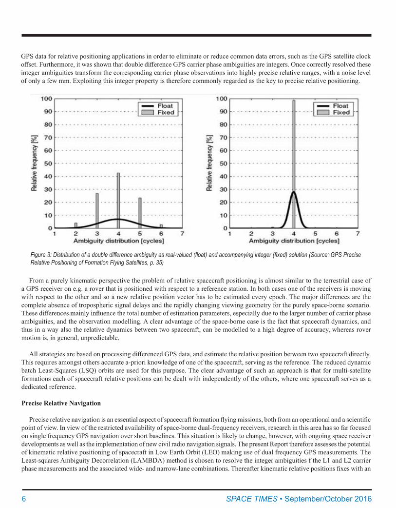
GPS data for relative positioning applications in order to eliminate or reduce common data errors, such as the GPS satellite clock offset. Furthermore, it was shown that double difference GPS carrier phase ambiguities are integers. Once correctly resolved these integer ambiguities transform the corresponding carrier phase observations into highly precise relative ranges, with a noise level of only a few mm. Exploiting this integer property is therefore commonly regarded as the key to precise relative positioning.
Figure3:Distributionofadoubledifferenceambiguityasreal-valued(float)andaccompanyinginteger(fixed)solution(Source:GPSPreciseRelative Positioning of Formation Flying Satellites, p. 35)
From a purely kinematic perspective the problem of relative spacecraft positioning is almost similar to the terrestrial case of a GPS receiver on e.g. a rover that is positioned with respect to a reference station. In both cases one of the receivers is moving with respect to the other and so a new relative position vector has to be estimated every epoch. The major differences are the complete absence of tropospheric signal delays and the rapidly changing viewing geometry for the purely space-borne scenario. These differences mainly influence the total number of estimation parameters, especially due to the larger number of carrier phase ambiguities, and the observation modelling. A clear advantage of the space-borne case is the fact that spacecraft dynamics, and thus in a way also the relative dynamics between two spacecraft, can be modelled to a high degree of accuracy, whereas rover motion is, in general, unpredictable.
All strategies are based on processing differenced GPS data, and estimate the relative position between two spacecraft directly. This requires amongst others accurate a-priori knowledge of one of the spacecraft, serving as the reference. The reduced dynamic batch Least-Squares (LSQ) orbits are used for this purpose. The clear advantage of such an approach is that for multi-satellite formations each of spacecraft relative positions can be dealt with independently of the others, where one spacecraft serves as a dedicated reference.
Precise Relative Navigation
Precise relative navigation is an essential aspect of spacecraft formation flying missions, both from an operational and a scientific point of view. In view of the restricted availability of space-borne dual-frequency receivers, research in this area has so far focused on single frequency GPS navigation over short baselines. This situation is likely to change, however, with ongoing space receiver developments as well as the implementation of new civil radio navigation signals. The present Report therefore assesses the potential of kinematic relative positioning of spacecraft in Low Earth Orbit (LEO) making use of dual frequency GPS measurements. The Least-squares Ambiguity Decorrelation (LAMBDA) method is chosen to resolve the integer ambiguities f the L1 and L2 carrier phase measurements and the associated wide- and narrow-lane combinations. Thereafter kinematic relative positions fixes with an

7
Figure 4: Navigation Solution Performance Requirements (Source: GPS Precise Relative Positioning of Formation Flying Satellites, p. 117)
accuracy limited only by the carrier phase noise and the geometric dilution of precision can be obtained. The feasibility, accuracy and robustness of this processing scheme are illustrated using simulated GPS measurements for two spacecraft in LEO separated by baseline of 10-100 km.
Spacecraft Formation Flying Missions
Spacecraft formation flying is commonly considered as a key technology for advanced space missions. Compared to large individual spacecraft, the distribution of sensor systems to multiple platforms offers improved flexibility and redundancy, shorter times to mission and the prospect of being more cost-effective. Besides these advantages, satellite formations in Low Earth Orbit provide advanced science opportunities that cannot (or less easily) be realized with single spacecraft, such as measuring small scale variations in the Earth’s gravity field or higher resolution imagery and interferometry.
One of the fundamental issues of spacecraft formation flying is the determination of the relative state (position and velocity) between the satellite vehicles within the formation. Knowledge of these relative states in (near) real-time is important for operational aspects. In addition some of the scientific applications, such as high resolution interferometry, require accurate post-facto knowledge of these states instead. Therefore a suitable sensor system needs to be selected for each mission. The highest precision is obtained with optical metrology. Here, use is made of a laser interferometer, which measures the relative distances between satellites with mm to μm precision. A custom tailored radio frequency (RF) system, such as the Ka-Band Ranging system on GRACE, obtains the same kind of precision, but measures a biased range instead. The major drawbacks of both systems are the relatively narrow field of view, certainly for the optical system and the fact that only 1-dimensional measurements (ranges) are provided. This is where GPS, used as an RF metrology system, clearly makes a difference. As commonly known precise relative positioning between GPS receivers in geodetic networks is exercised on a routine basis. Furthermore GPS receivers are already frequently used onboard satellites to perform all kinds of navigational tasks, are suitable for real-time applications and provide measurements with a 3- dimensional nature. Therefore they are often considered as the primary instrument for relative navigation in future satellite formation flying missions.
Much of the research in spacecraft relative navigation conducted during the past decade has focused of the needs of formation
SPACE TIMES • September/October 2016

8 SPACE TIMES • September/October 2016
Figure 5: Artist’s Rendition of Satellites Flying in Formation (Source: Command-ing and Controlling Satellite Clusters, p. 9)
Figure 6: COSMO-SkyMED is the Satellite B and SABRINA the Satellite A in Formation Flying (Source: GPS Precise Relative Positioning of Formation Flying Satellites, p. 122)
control and maintenance in (near) real-time, which can generally be fulfilled by single frequency GPS sensors and dynamical Kalman filtering.
For this a single frequency GPS receiver is generally sufficient when the inter-satellite distance, or baseline, is restricted to a maximum of about 10 km. A few studies regarding rendezvous and docking applications used GPS data from actual demonstration missions.
GPS dual frequency carrier phase observations, in contrast, enable highly accurate, yet purely kinematic, relative navigation over baselines up to a few hundredths of kilometres. Furthermore, the use of dual frequency measurements notably improves the identification of systematic measurements errors and bad data points. It is therefore the method of choice, whenever a high accuracy and/or integrity of the navigation solution are demanded by the primary science goals. This is e.g. the case of the recovery of time

9
Figure 7: Fully Active (left) and Semi-Active (right) Formation Flying Multi-Static Radar Systems (Source: Bi- and Multistatic SAR: Potentials and Challenges, p. 1)
SPACE TIMES • September/October 2016
varying gravity field information using the GRACE twins or for future along-track Synthetic Aperture Radar (SAR) interferometry missions such as SABRINA Mission. While GPS is not the sole navigation sensor in these applications, it provides the necessary time synchronization, a 3-dimensional position restitution and allows and independent calibration of radar or laser based distance sensors. Even though space capable dual frequency receivers are still pretty limited today, the situation is expected to notably improve over the forthcoming years. The new L2C GPS signal as well as the upcoming Galileo constellation offer much better signal-to-noise ratios than the existing (semi-)codeless L2 tracking techniques and will certainly trigger developments of new space receivers.
In order to obtain the best possible navigation results the integer nature of the double difference (DD) carrier phase ambiguities has to be exploited. The study uses a Real Time Kinematic (RTK) type of approach where the initial DD integer phase ambiguities are estimated using the LAMDBA (Least-Squares Ambiguity Decorrelation Adjustment) method. Once the individual integer DD ambiguities are resolved the ionosphere free double DD carrier phase observation are used to determine the relative position, which is done in a sequential way between the epochs. New ambiguities are also estimated using the LAMBDA method but with a much smaller model. The probability as obtained from the LAMBDA method is used as a test for validation of the integer DD ambiguities.
Both pseudo-range and carrier phase measurements are therefore required in the start-up phase and at constellation changes to resolve the integer ambiguities. Other than in terrestrial application, however, the rapidly changing line-of-sight vectors to the GPS Satellites support a fast ambiguity resolution for formation flying spacecraft and good confidence ambiguities are typically obtained within 2 to 3 minutes.
After fixing the DD ambiguities to integer wavelengths the relative position of both receivers at each epoch can be recovered with an accuracy determined essentially by the Position Dilution of Precision (PDOP) and the measurement noise of the receivers.
Overall Processing and Positioning Strategy
The overall processing and positioning strategy is of a Real Time Kinematic (RTK) type of approach consisting of three mayor processing steps:
• Complete initialization of all DD ambiguities• Partial (re)initialization of new DD ambiguities• Relative positioning with DD carrier phase observations and known integer ambiguities
All integer DD ambiguity initialization (complete as well as partial) is done by using the LAMBDA method, which is the purest form of integers least squares and is therefore the most optimum search method. For complete ambiguity initialization both the DD

10 SPACE TIMES • September/October 2016
Figure 8: Formulation of double difference (DD) observations for spacecraft relative navigation (Source: GPS Precise Relative Positioning of Formation Flying Satellites, p. 49)
Figure 9: GPS Satellites 3D Orbital Positions (Source: GPS Precise Relative Positioning of Formation Flying Satellites, p. 85)

11
Figure 10: Receiver 3D Orbital Position (Source: GPS Precise Relative Position-ing of Formation Flying Satellites, p. 83)
SPACE TIMES • September/October 2016
Figure 11: TanDEM-X and TerraSAR-X Spacecrafts in Formation Flying (Source: DLR)

12 SPACE TIMES • September/October 2016
Figure 12: Landsat-7 and EO-1 Spacecrafts in Formation Flying (Source: NASA)
Figure 13: Jason-2 and Jason-3 Spacecrafts in Formation Flying (Source: EUMETSAT)
pseudo-range and carrier phase data are accumulated over multiple epochs , according to the model discussed in the next section, until the probability of having found the correct integer ambiguities has exceeded a predefined threshold and the correct integer ambiguities are supposed o have been found. After the initial ambiguities have been found they are kept constant over time and are used for relative positioning with DD carrier phase observations. This is done for every epoch until a new GPS SV is observed

13SPACE TIMES • September/October 2016
or until a cycle slip is detected, which will result in new ambiguities to be estimated.
For partial initialization (new ambiguities) a similar approach as for complete initialization is used with the only difference that pseudo-range data is only needed for the DD pairs with unknown ambiguities. Apart from the fact that the RTK approach can be applied to real time systems it has the advantage of minimizing the amount of pseudo-range data needed and the ability of rigorous cycle slip/phase data anomaly detection.
MLAMBDA: Modified LAMBDA Method for Integer Least-Squares Estimation
The LAMBDA method has been widely used in GNSS for fixing integer ambiguities. It can also solve any Integer Least Squares (ILS) problem arising from other applications. For real time applications with high dimensions, the computational speed is crucial. A modified LAMBDA method (MLAMBDA) is presented. Several strategies are proposed to reduce the computational complexity of the LAMBDA method. Numerical simulations show that MLAMBDA is (much) faster than LAMBDA. The relation between the LAMBDA method and some relevant methods in the information theory literature are pointed out when we introduce its main procedures.
The well-known LAMBDA method has been widely used for the integer least-squares estimation problems in positioning and navigation. We pointed out its close relations with the ILS methods developed for the other applications in the literature. The LAMBDA method consists of two stages, reduction and search. I presented a modified LAMBDA method (MLAMBDA) which improves both this two stages. The key to the algorithm is to compute the factorization with symmetric pivoting, de-correlate the parameters by greedy selection and lazy transformations, and shrink the ellipsoidal region during the search process. Numerical simulation showed that MLAMBDA can be much faster than LAMBDA implemented for high dimensional problems. This will be particularly useful to integer ambiguity determination when there are more GNSS satellites visible simultaneously, with carrier phase observations on three frequencies in the future. I gave complete computational details for this new method.
GPS Receiver SW Simulator
The GPS Receiver SW Simulator is a Software Program, all written in Fortran 77, which comprises a Main Program that recalls various Subroutines, Functions and Libraries. The Simulator operates tests about different scenarios concerning the Simulated In-Orbit Behaviour of a GPS Receiver and the Orbital Dynamic of the Navstar GPS Constellation.
The SW Simulator reproduces two different main scenarios:
• The first one is represented by the Simulated Operative Behaviour Physics in which the GPS Receiver operates that is the Orbital Mechanics and the Physical Degradations and Delays which affect the In Space GPS Signal transmitted from GPS Satellites to In Orbit GPS Receiver.
• The second one is about the GPS Receiver Behaviour and Performances as far as:
o Receiver estimations and measures of the GPS Signal Degradations due to the Received GPS Signal (Code and Phase) Acquisition and Tracking Processes;
o Pseudo-range and Pseudo-range-Rate Equations Systems Resolution for In Orbit Receiver Position and Velocity determination.
The Receiver inner electronic behaviour is estimated by using statistical values of Signal degradations and delays due to the inner Received Signal Acquisition and Tracking Loops. The GPS SW Simulator is constituted by sub-programmes and mathematical models which simultaneously cooperate interacting between themselves at each simulation time to reconstruct the complete Receiver Operative Behaviour Dynamics.
The SW Simulator reproduces In Orbit Receiver Position and Velocity through an orbital propagation starting from the acquisition

14 SPACE TIMES • September/October 2016
Figure 14: Formulation of double difference (DD) observations for spacecraft rela-tive to navigation (Source: GPS Precise Relative Positioning of Formation Flying Satellites, p. 49)
of input orbital parameters chosen by user at a certain date. The orbital propagation programme used has been previously tested and validated and represents the principal SW simulation instrument of the Receiver Orbital Dynamics at each simulation time since it comprises all the orbital perturbation models.
The SW Simulator reconstructs the operative NAVSTAR GPS Satellites perturbed orbital dynamics. At each time of simulation a free-of-charge, tested and validated Fortran 77 Propagation Program, given by the U.S. NORAD, calculates the GPS Satellites Positions and Velocities using perturbations models chosen by user. It represents the principal SW simulation instrument of the GPS Constellation Orbital Dynamics.
The GPS SW Simulator calculates the physical degradations which cause Receiver Signal reception delays and calculates also the free space signal propagation time interval. The signal degradations are determined in terms of time delays (seconds) also

15SPACE TIMES • September/October 2016
scaled in pseudo-ranges (meters) and delta frequencies (Hertz). The mathematical model, which calculates the free space signal propagation time interval, uses an iterative algorithm until it catches up a 10^-20 precision threshold value.
Conclusions
From a careful statistical study and from an accurate comparison between the SW Simulator Data Graphics and those reported in the Test Reports I can conclude that the GPS SW Simulator supplies statistically the same results of the real Receiver for how much it concerns the signal physical degradations measures, the GPS Constellation visibility calculus and the determination of Pseudo-range measures, Pseudo-range-rate measures, Integrated Pseudo-range measures, Integrated Doppler measures, Integrated Doppler-rate measures and Delta Pseudo-range measures.
As far as the performances, that is the accuracy obtained in the Receiver Position and Velocity SPS solutions determination, the Receiver statistical precision values are of the same order of magnitude of those contained in the Test Reports even if the values are greater as mean values and 1 sigma. This is due to the fact that the SW Simulator, at the actual state of the art, doesn’t take care of the calculus of the signal degradation processes and delays connected to the Receiver inner GPS Signal treatment as the Signal Acquisition, Correlation and Tracking Loops. It considers this type of delays statistically as previously mentioned in the section dedicated to the signal degradation description.
Moreover the Singular Value Decomposition (SVD) method used in the SPS solutions doesn’t take into consideration the covariance matrix referred to the Receiver pseudo-range and carrier phase measures. It causes worse precision performances in the correction of the Receiver Position and Velocity estimates at each simulation time. Consequently the Receiver Position and Velocity SPS solutions result less near to the real Receiver Position and Velocity values than the case in which the covariance matrices are used in the calculus.
Figure 15: Baseline Error Norm in m (Source: GPS Precise Relative Positioning of Formation Flying Satellites, p. 146)
The SW Simulator reconstructs all the physical signal degradations and statistically treats the delays related to the Receiver inner signal treatment processes and this category of degradations are statistically, as measure values, of the same order of magnitude of those resulting from the real Receiver Test Campaign. The SW Simulator also reconstructs the Receiver Mission Operative Environment simulating the physics which governs both the Receiver Orbital Dynamic and the GPS Constellation Orbital Dynamic

16 SPACE TIMES • September/October 2016
Michelangelo Ambrosini is a senior space professional with strong work experience in national and international space industries, agencies, organization and associations. His background and expertise are Aerospace, Aeronautical, Astronautical and Space Engineering, Human Spaceflight, Space Exploration, Rocket Science and Space Mission Operations. He is also an AAS senior member. ([email protected] Flughafenstr. 2, 64347 Griesheim, Germany)
Figure 16: Satellite B Error Norm in m (Source: GPS Precise Relative Positioning of Formation Flying Satellites, p. 146)
considering all types of orbital perturbations.
Moreover the SW Simulator architecture is predisposed to an further integration phase with new mathematical models which could improve the performances and take them nearer to those of the real Receiver as, for example and above all, the GPS signal models and the Receiver inner signal treatment processes. The simulations of the GPS data processing with the SW tools for the accurate baseline determination have reached the requested preliminary mission performances which are accuracies on each ECI component in space of the order of 1 cm as Standard Deviation in very short computational time for simulations time periods of 1 orbit.
The book is available online at the following link: http://tinyurl.com/hhf26mc
SAVE THE DATES!55th Robert H. Goddard Memorial Symposium
Greenbelt Marriott ♦ Greenbelt, MarylandMarch 7-9, 2017
6th ISS Research and Development ConferenceOmni Shoreham ♦ Washington, D.C.
July 18-20, 2017