Page 58 PART 6 – Conservation, heritage and …...Significant areas of lowland heathland falls...
9
Haldon Forest Plan 2018 - 2028 Page 58 PART 6 – Conservation, heritage and recreation
Transcript of Page 58 PART 6 – Conservation, heritage and …...Significant areas of lowland heathland falls...

Haldon Forest Plan
2018 - 2028
Page 58
PART 6 – Conservation, heritage and recreation
Haldon Forest Plan
2018 - 2028
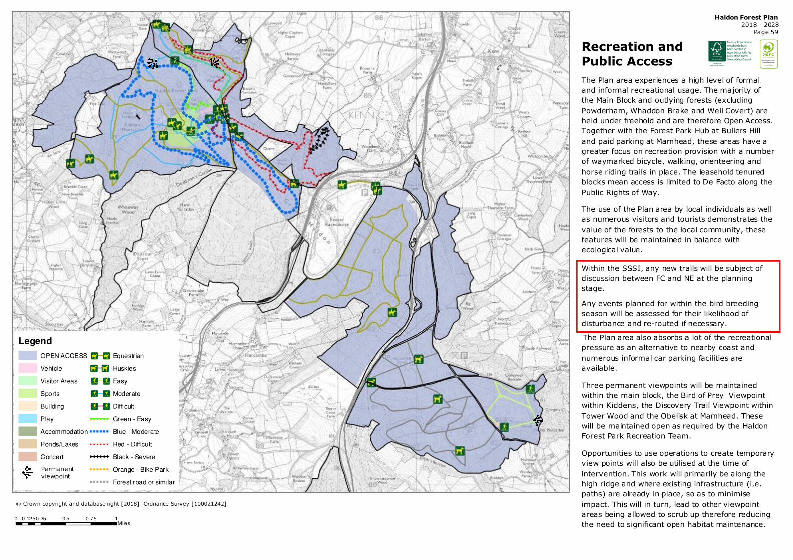
Page 59
Recreation and
Public Access
The Plan area experiences a high level of formal
and informal recreational usage. The majority of
the Main Block and outlying forests (excluding
Powderham, Whaddon Brake and Well Covert) are
held under freehold and are therefore Open Access.
Together with the Forest Park Hub at Bullers Hill
and paid parking at Mamhead, these areas have a
greater focus on recreation provision with a number
of waymarked bicycle, walking, orienteering and
horse riding trails in place. The leasehold tenured
blocks mean access is limited to De Facto along the
Public Rights of Way.
The use of the Plan area by local individuals as well
as numerous visitors and tourists demonstrates the
value of the forests to the local community, these
features will be maintained in balance with
ecological value.
Within the SSSI, any new trails will be subject of
discussion between FC and NE at the planning
stage.
Any events planned for within the bird breeding
season will be assessed for their likelihood of
disturbance and re-routed if necessary.
The Plan area also absorbs a lot of the recreational
pressure as an alternative to nearby coast and
numerous informal car parking facilities are
available.
Three permanent viewpoints will be maintained
within the main block, the Bird of Prey Viewpoint
within Kiddens, the Discovery Trail Viewpoint within
Tower Wood and the Obelisk at Mamhead. These
will be maintained open as required by the Haldon
Forest Park Recreation Team.
Opportunities to use operations to create temporary
view points will also be utilised at the time of
intervention. This work will primarily be along the
high ridge and where existing infrastructure (i.e.
paths) are already in place, so as to minimise
impact. This will in turn, lead to other viewpoint
areas being allowed to scrub up therefore reducing
the need to significant open habitat maintenance.
Legend
OPEN ACCESS
Vehicle
Visitor Areas
Sports
Building
Play
Accommodation
Ponds/Lakes
Concert
!È !È Equestrian
�Í �Í Huskies
�Ô �Ô Easy
�Ô �Ô Moderate
�Ô �Ô Difficult
! ! ! ! ! ! Green - Easy
� � � � � � Blue - Moderate
# # # # # # Red - Difficult
XXXXXX Black - Severe
! ! ! ! ! ! Orange - Bike Park
! ! ! ! ! ! Forest road or similar
© Crown copyright and database right [2018] Ordnance Survey [100021242]
0 0.25 0.5 0.75 10.125Miles
Permanent
viewpoint

Haldon Forest Plan
2018 - 2028
Page 60
Legend
OPEN ACCESS Vehicle
Visitor Areas
Sports
Build ing
Play
Accommodation
Ponds/Lakes
Concert
!È !È Equestrian
�Í �Í Huskies
�Ô �Ô Easy
�Ô �Ô Moderate
�Ô �Ô Difficult
! ! ! ! ! ! Green - Easy
� � � � � � Blue - Moderate
# # # # # # Red - Difficult
XXXXXX Black - Severe
! ! ! ! ! ! Orange - Bike Park
! ! ! ! ! ! Forest road or similar
© Crown copyright and database right [2018]
Ordnance Survey [100021242]
0 0.25 0.5 0.75 10.125Miles
Haldon Forest Plan
2018 - 2028
Page 61
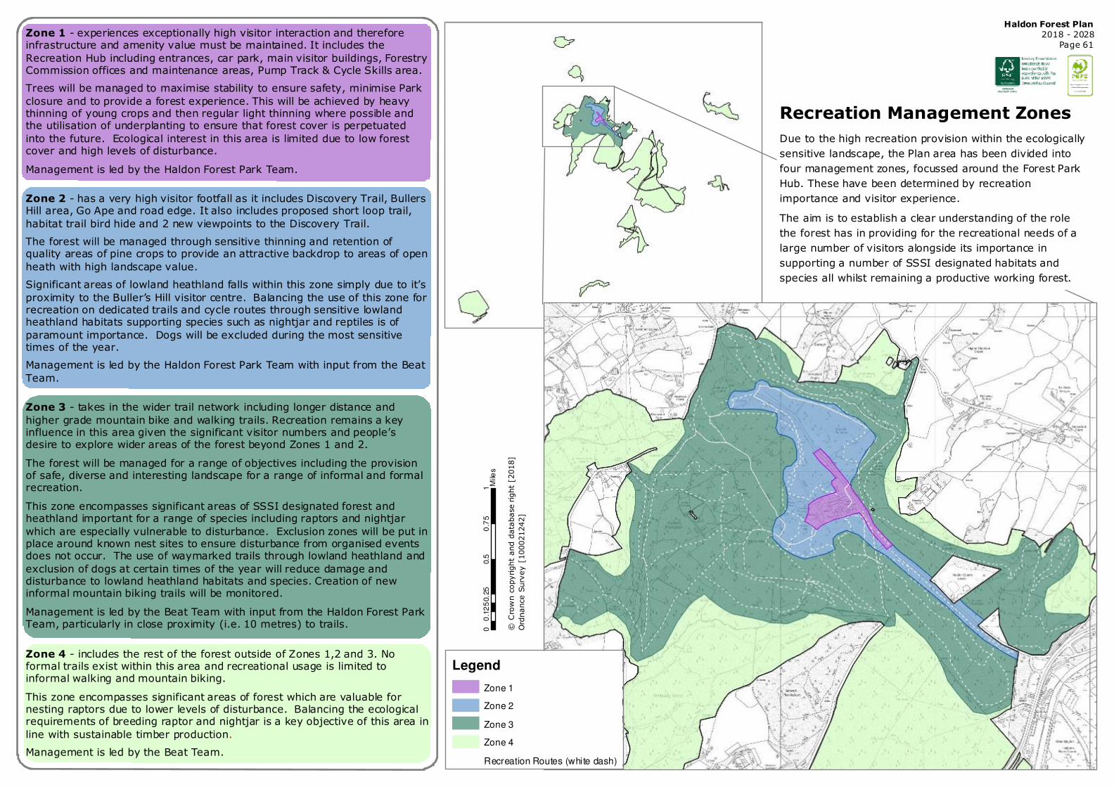
Zone 1 - experiences exceptionally high visitor interaction and therefore infrastructure and amenity value must be maintained. It includes the
Recreation Hub including entrances, car park, main visitor buildings, Forestry Commission offices and maintenance areas, Pump Track & Cycle Skills area.
Trees will be managed to maximise stability to ensure safety, minimise Park
closure and to provide a forest experience. This will be achieved by heavy thinning of young crops and then regular light thinning where possible and the utilisation of underplanting to ensure that forest cover is perpetuated
into the future. Ecological interest in this area is limited due to low forest cover and high levels of disturbance.
Management is led by the Haldon Forest Park Team.
Zone 2 - has a very high visitor footfall as it includes Discovery Trail, Bullers Hill area, Go Ape and road edge. It also includes proposed short loop trail,
habitat trail bird hide and 2 new viewpoints to the Discovery Trail.
The forest will be managed through sensitive thinning and retention of quality areas of pine crops to provide an attractive backdrop to areas of open
heath with high landscape value.
Significant areas of lowland heathland falls within this zone simply due to it’s
proximity to the Buller’s Hill visitor centre. Balancing the use of this zone for recreation on dedicated trails and cycle routes through sensitive lowland heathland habitats supporting species such as nightjar and reptiles is of
paramount importance. Dogs will be excluded during the most sensitive times of the year.
Management is led by the Haldon Forest Park Team with input from the Beat
Team.
Zone 3 - takes in the wider trail network including longer distance and
higher grade mountain bike and walking trails. Recreation remains a key influence in this area given the significant visitor numbers and people’s desire to explore wider areas of the forest beyond Zones 1 and 2.
The forest will be managed for a range of objectives including the provision of safe, diverse and interesting landscape for a range of informal and formal recreation.
This zone encompasses significant areas of SSSI designated forest and heathland important for a range of species including raptors and nightjar
which are especially vulnerable to disturbance. Exclusion zones will be put in place around known nest sites to ensure disturbance from organised events does not occur. The use of waymarked trails through lowland heathland and
exclusion of dogs at certain times of the year will reduce damage and disturbance to lowland heathland habitats and species. Creation of new informal mountain biking trails will be monitored.
Management is led by the Beat Team with input from the Haldon Forest Park Team, particularly in close proximity (i.e. 10 metres) to trails.
Zone 4 - includes the rest of the forest outside of Zones 1,2 and 3. No formal trails exist within this area and recreational usage is limited to informal walking and mountain biking.
This zone encompasses significant areas of forest which are valuable for nesting raptors due to lower levels of disturbance. Balancing the ecological requirements of breeding raptor and nightjar is a key objective of this area in
line with sustainable timber production.
Management is led by the Beat Team.
Recreation Management Zones
Due to the high recreation provision within the ecologically
sensitive landscape, the Plan area has been divided into
four management zones, focussed around the Forest Park
Hub. These have been determined by recreation
importance and visitor experience.
The aim is to establish a clear understanding of the role
the forest has in providing for the recreational needs of a
large number of visitors alongside its importance in
supporting a number of SSSI designated habitats and
species all whilst remaining a productive working forest.
Legend
Zone 1
Zone 2
Zone 3
Zone 4
Recreation Routes (white dash)
© Crown copyright and database right [2018]
Ordnance Survey [100021242]
00.2
50.5
0.7
51
0.1
25
Mile
s

Haldon Forest Plan
2018 - 2028
Page 62
Legend
Area A
Area B
Area C
Area D
Area E
Area F
Recreation Facilities
Recreation Routes (white)
A
B
A
A
C
F
F
D
E
B
Operation Units & Working To balance the impact of forest operations on the
high recreation provision and visitor numbers around
the Forest Park Hub area, the Main Block has been
divided into six operational blocks. The intention is
work these areas on a rotation so that forest
operations are discreet and do not adversely affect
the visitor experience.
The aim will be for operations to be targeted, swift
and to a very high standard, utilising interpretation
where appropriate so that the Haldon Forest
becomes a showcase for exemplary forest
management.
Opportunities to use operations to create temporary
(e.g. ten year) view points will be utilised. These
areas will be less than 0.5 ha and therefore within
the threshold OF cms6.
© Crown copyright and database right [2018] Ordnance Survey [100021242]
0 0.25 0.5 0.75 10.125Miles
Haldon Forest Park Hub
Recreation Routes (white )

Haldon Forest Plan
2018 - 2028
Page 63
Conservation -
Ride sides & Habitats
Ride and road sides, together with watercourses and
hedgerow management will conform to the
prescriptions outlined in the District document, Design
and Management of Environmental Corridors (2017).
This document outlines the management of light
levels, pinch points and forest edge dynamics and is
agreed with Forest Services. The objective is to use
the ride network to extend and connect with the
surrounding heathland, this will be achieved through
proactive, targeted widening and unstocking of edges
to some coupes following felling operations to create a
mixed transient open and diffuse scrubby habitat.
Where appropriate, following felling and cleaning
operations, opportunities will taken to extend and
buffer the priority habitats underlined. This work will
be focussed on areas highlighted with red hatch - - -
over the Plan period.
Legend
Haldon SSSI
Moor and Heath
Hedgerow
Forest Road Edge
Conservation + Recreation
Public Roadside
Windthrow protection
Watercourse
Broadleaved Belt
Lowland beech/yew woodland
Wet woodland
Lowland heathland
Lowland mixed deciduous woodland
BROADLEAVED; MIXED/YEW WOODLANDS
CONIFEROUS WOODLANDS
BOUNDARY & LINEAR FEATURES
NEUTRAL GRASSLAND
ACID GRASSLAND
BRACKEN
INLAND ROCK
d dSurveyed; Unknown Habitat
Wet woodland Occurs in a
number of areas of the Plan area
where soils are poorly drained or
seasonally wet such as flushes and
streams ides with alder, birch and
willow the predominant species.
These will continue to be managed
sensitively with attention paid to
ensuring light levels promote
favourable habitat conditions.
© Crown copyright and database right [2028]
Ordnance Survey [100021242]
0 0.25 0.5 0.75 10.125Miles
Lowland Mixed Deciduous Woodland will be managed
sensitively to ensure the quality is maintained in perpetuity.
Thinning will be reviewed on a ten yearly cycle with the aim of
enhancing and improving the condition of the habitat. Removal
of invasive or un-suitable species, such as laurel, rhododendron
or Western hemlock will ensure that this habitat is maintained
and used as a building block for future native broadleaf
restoration.
Bracken occurs frequently on the acidic soils within the
Haldon Plan area. Although it can become invasive and
requires management through cutting, rolling and
spraying, a patchy mosaic of bracken is maintained along
the Kiddens powerline for the habitat requirements of the
small and pearl-bordered fritillary butterflies.
Lowland heathland is typically made
up of an assemblage dwarf shrubs such
as heather and gorse as well as
grasses such as Erica cinerea, Erica
tetralix and Molinea caerula on shallow
peats. The majority of heathland sites
are located along the Haldon ridge.
Managed as permanent open habitat
with no more than 20% tree cover
through mechanical cutting of
regenerating tree species, the plan will
aim to connect these areas through a
well managed ride network.
Haldon Forest Plan
2018 - 2028
Page 64
Legend
Moor and Heath
Hedgerow
Forest Road Edge
Conservation + Recreation
Public Roadside
Windthrow protection
Watercourse
Broadleaved Belt
Lowland beech/yew woodland
Wet woodland
Lowland heathland
Lowland mixed deciduous woodland
BROADLEAVED; MIXED/YEW WOODLANDS
CONIFEROUS WOODLANDS
BOUNDARY & LINEAR FEATURES
NEUTRAL GRASSLAND
ACID GRASSLAND
BRACKEN
INLAND ROCK
d dSurveyed; Unknown Habitat
© Crown copyright and database right [2028] Ordnance Survey [100021242] 0 0.25 0.5 0.75 10.125Miles
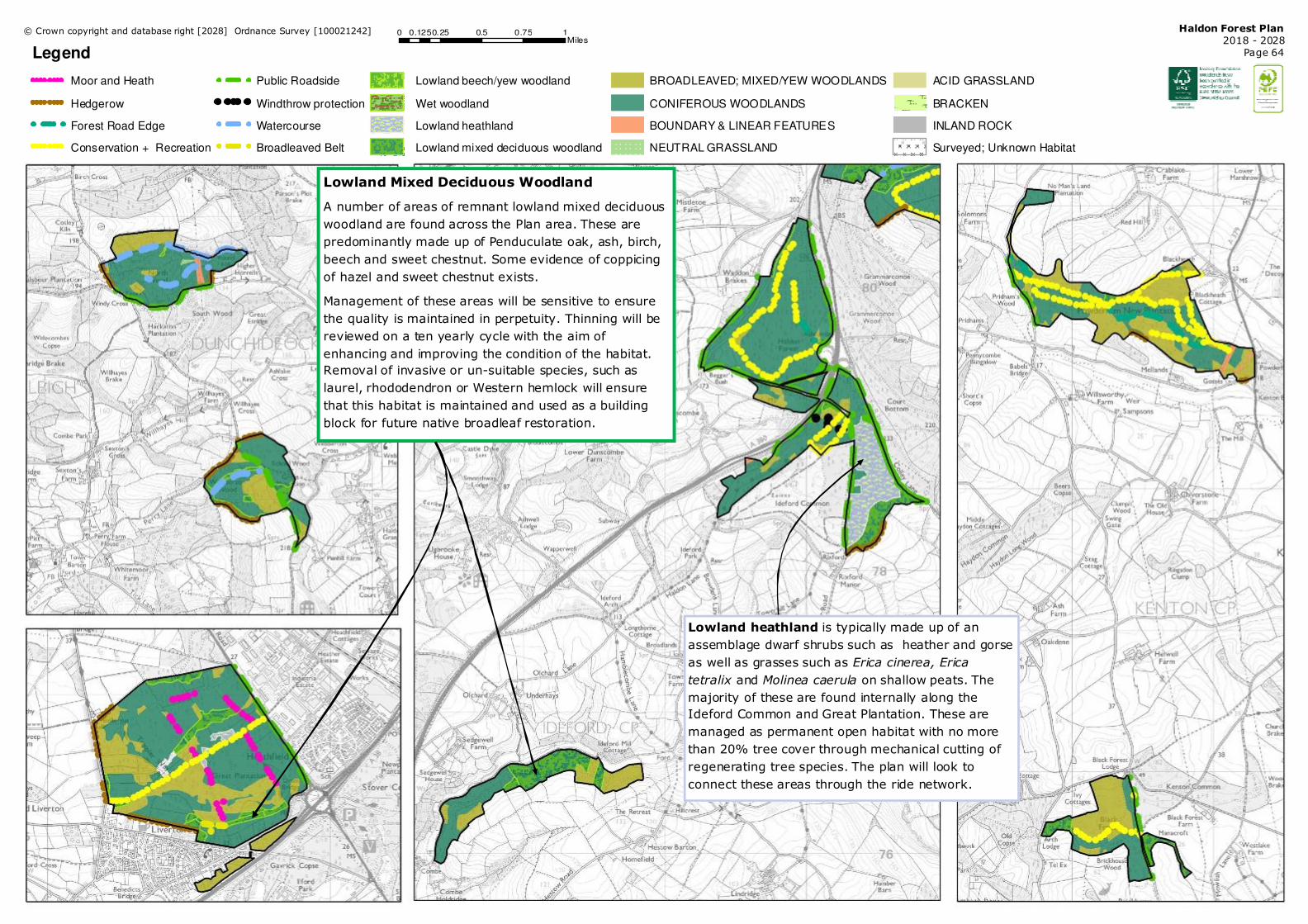
Lowland Mixed Deciduous Woodland
A number of areas of remnant lowland mixed deciduous
woodland are found across the Plan area. These are
predominantly made up of Penduculate oak, ash, birch,
beech and sweet chestnut. Some evidence of coppicing
of hazel and sweet chestnut exists.
Management of these areas will be sensitive to ensure
the quality is maintained in perpetuity. Thinning will be
reviewed on a ten yearly cycle with the aim of
enhancing and improving the condition of the habitat.
Removal of invasive or un-suitable species, such as
laurel, rhododendron or Western hemlock will ensure
that this habitat is maintained and used as a building
block for future native broadleaf restoration.
Lowland heathland is typically made up of an
assemblage dwarf shrubs such as heather and gorse
as well as grasses such as Erica cinerea, Erica
tetralix and Molinea caerula on shallow peats. The
majority of these are found internally along the
Ideford Common and Great Plantation. These are
managed as permanent open habitat with no more
than 20% tree cover through mechanical cutting of
regenerating tree species. The plan will look to
connect these areas through the ride network.

Haldon Forest Plan
2018 - 2028
Page 65
Conservation - Features The Forest Plan area is used by a number of interesting flora and fauna some of which are highlighted
below. Haldon Forest and its associated open habitats make a significant contribution to the provision of
semi-natural habitats in the wider landscape.
On the other hand some non-native flora and grazing fauna species can have a detrimental impact on
the forest and its features if their numbers are too high. Species such as rhododendron, encroaching
wild deer, grey squirrel and boar will all be managed in line with District Strategy to ensure that their
pressure does not have a negative impact on the condition of habitats and crops.
Dormouse favourable habitat is
found throughout the Plan area,
and there are records of this
species in Kiddens and Lucy Balls
(see map) but also in Great
Plantation and Webberton.
This European Protected Species
requires pinch points across
corridors to allow habitat
connectivity between broadleaved
woodland, particularly in stands
with a high hazel and/or sweet
chestnut components. The
prescriptions outlined in the
Environmental Corridors
document will ensure appropriate
habitat provision and
management will be in line with
Best Practice Guidance (FC & NE,
2007).
Trees of Significant Interest (TSI) are found throughout
the Plan area and will be retained in perpetuity. The majority of
these trees are beech but also include wild service, crab apple and
oak. When crops are thinned crowns will be released slowly to
minimise the impact of sudden exposure to desiccating winds and
sun scorch. Management will be in line with FC TSI Guidance (Ops © Crown copyright and database right [2028]
Ordnance Survey [100021242]
0 0.25 0.5 0.75 10.125Miles
Turtle Dove is a severely declining bird which once used Haldon Forest SSSI as a sanctuary and was
designated accordingly. This bird prefers to inhabit hedgerows (particularly hawthorn), woodland edges and
scrub, however due, in part, to the agricultural intensification it is in steep decline. Haldon has some
rumoured sightings of Turtle Dove in recent years but confirmed sightings have been absent for a number
of years. Management will aim to provide areas of dense scrub and shrub layers along woodland edge and
seed rich habitat throughout open grassland and rides.
Grizzled and Dingy Skipper (pictured) are becoming increasingly rare in the UK. The
Kiddens area of the Plan area is home to a vibrant population of the butterfly. Favouring
warm sheltered areas with sparse vegetation including ride sides, woodland clearings and
abandoned quarries, both species will benefit from the clearfelling programme as well as
the environmental corridor work proposed in this Plan.

Haldon Forest Plan
2018 - 2028
Page 66
Legend
Scheduled Monument
Unscheduled Monument
Mamhead Park Registered Park and Garden
Powderham Castle Registered Park and Garden
Heritage Features
People have lived and farmed on Haldon for at least
5,000 years. It has been both a barrier to transport
but also a commanding position from which to control
the surrounding countryside. The Plan area holds a
number of indications of this rich cultural heritage
some of which can be dated back to the Bronze age.
These include disused settlements, barrows, wells and
kilns.
Windy Cross Scheduled Monument, is situated 13m
north of the crossroads, at the southern edge of North
Wood. It is aligned NNW to SSE. The cross survives as
a simple Latin cross which is octagonal in section, and
is Listed Grade II. It is most likely a Christian cross
erected during the medieval period between the 9th
and 15th centuries AD
More recent indications also exist: Mamhead Park
(now a Registered Park and Garden) was once owned
by the Balle family, then the Newmans who rebuilt the
house to the designs of famous architect Anthony
Salvin. Lancelot ‘Capability’ Brown landscaped the
gardens. The famous Obelisk, erected c1742 by
Thomas Balle stands 100 feet high and was used as a
navigational aid for the Exe estuary.
Numerous other heritage features, including boundary
stones and crop marks, are within the Plan area and
are recorded within the Historic Environment Record.
This database, and where appropriate experts, will be
consulted before operations take place to ensure
features are preserved for the future enlightenment
and education and enhanced though management.
Mature hedgebanks are found throughout the Plan
area and are managed at the time of operation in line
with the District document, Design and Management
of Environmental Corridors (2017).
© Crown copyright and database right [2018]
Ordnance Survey [100021242]
0 0.75 1.5 2.25 30.375Miles