Padelford Riverboats Harriet Island • St. Paul, MN 55107 (651) 227
2
Science Museum of Minnesota Mile 839.6 6 5 3 1 7 8 9 10 Padelford Riverboats St. Paul Padelford Landing, Harriet Island West Home port of riverboats Jonathan Padelford, Anson Northrup and Betsey Northrup. 11 2 4 St. Peter’s Church Minnesota’s oldest existing church, built in 1853. Minnehaha Falls Lock & Dam #1 Harriet Island • St. Paul, MN 55107 (651) 227-1100 www.riverrides.com Padelford Riverboats St. Paul You depart from our landing across the river from downtown St. Paul and quickly disappear into an island of nature in the midst of this major metropolitan area. Traveling through the heart of the Great River National Park you may spot great blue herons, cormorants, hawks, peregrine falcons, and even a bald eagle. Also, the park area is rich in the early history of Minnesota. See the site of Pig’s Eye Parrant’s cave where the city of St. Paul began and get a river view of Fort Snelling, where just about everything in Minnesota originated. Fort Snelling Col. Josiah Snelling took command and began building the fort in 1820. Originally called Fort St. Anthony, Lt. Zebulon Pike selected the area for a fort in 1805 and neotiated a nine square mile land grant with the Indians. Henry Sibley Home Henry Sibley’s home was the first stone residence in the state in 1834. He was Minnesota’s first Governor and partner with Jean Baptiste Faribault, who lived next door.
Transcript of Padelford Riverboats Harriet Island • St. Paul, MN 55107 (651) 227
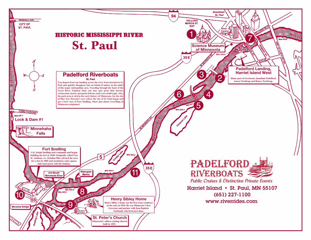
Science Museumof Minnesota
Mile 839.6
65
3
1 7
89
10
Padelford RiverboatsSt. Paul
Padelford Landing,Harriet Island West
�H�o�m�e� �p�o�r�t� �o�f� �r�i�v�e�r�b�o�a�t�s� �J�o�n�a�t�h�a�n� �P�a�d�e�l�f�o�r�d�,�A�n�s�o�n� �N�o�r�t�h�r�u�p� �a�n�d� �B�e�t�s�e�y� �N�o�r�t�h�r�u�p�.�
11
2
4
St. Peter’s Church�M�i�n�n�e�s�o�t�a�’�s� �o�l�d�e�s�t� �e�x�i�s�t�i�n�g� �c�h�u�r�c�h�,
�b�u�i�l�t� �i�n� �1�8�5�3�.�
MinnehahaFalls
Lock & Dam #1
Harriet Island • St. Paul, MN 55107(651) 227-1100
www.riverrides.com
Padelford RiverboatsSt. Paul
�Y�o�u� �d�e�p�a�r�t� �f�r�o�m� �o�u�r� �l�a�n�d�i�n�g� �a�c�r�o�s�s� �t�h�e� �r�i�v�e�r� �f�r�o�m� �d�o�w�n�t�o�w�n� �S�t�.� �P�a�u�l� �a�n�d� �q�u�i�c�k�l�y� �d�i�s�a�p�p�e�a�r� �i�n�t�o� �a�n� �i�s�l�a�n�d� �o�f� �n�a�t�u�r�e� �i�n� �t�h�e� �m�i�d�s�t� � � �o�f� �t�h�i�s� �m�a�j�o�r� �m�e�t�r�o�p�o�l�i�t�a�n� �a�r�e�a�.� �T�r�a�v�e�l�i�n�g� �t�h�r�o�u�g�h� �t�h�e� �h�e�a�r�t� �o�f� �t�h�e� �G�r�e�a�t� �R�i�v�e�r� �N�a�t�i�o�n�a�l� �P�a�r�k� �y�o�u� �m�a�y� �s�p�o�t� �g�r�e�a�t� �b�l�u�e� �h�e�r�o�n�s�,� �c�o�r�m�o�r�a�n�t�s�,� �h�a�w�k�s�,� �p�e�r�e�g�r�i�n�e� �f�a�l�c�o�n�s�,� �a�n�d� �e�v�e�n� �a� �b�a�l�d� �e�a�g�l�e�.� �A�l�s�o�,� �t�h�e� �p�a�r�k� �a�r�e�a� �i�s� �r�i�c�h� �i�n� �t�h�e� �e�a�r�l�y� �h�i�s�t�o�r�y� �o�f� �M�i�n�n�e�s�o�t�a�.� �S�e�e� �t�h�e� �s�i�t�e� �o�f� �P�i�g�’�s� �E�y�e� �P�a�r�r�a�n�t�’�s� �c�a�v�e� �w�h�e�r�e� �t�h�e� �c�i�t�y� �o�f� �S�t�.� �P�a�u�l� �b�e�g�a�n� �a�n�d� �g�e�t� �a� �r�i�v�e�r� �v�i�e�w� �o�f� �F�o�r�t� �S�n�e�l�l�i�n�g�,� �w�h�e�r�e� �j�u�s�t� �a�b�o�u�t� �e�v�e�r�y�t�h�i�n�g� �i�n� �M�i�n�n�e�s�o�t�a� �o�r�i�g�i�n�a�t�e�d�.
Fort Snelling�C�o�l�.� �J�o�s�i�a�h� �S�n�e�l�l�i�n�g� �t�o�o�k� �c�o�m�m�a�n�d� �a�n�d� �b�e�g�a�n� �b�u�i�l�d�i�n�g� �t�h�e� �f�o�r�t� �i�n� �1�8�2�0�.� �O�r�i�g�i�n�a�l�l�y� �c�a�l�l�e�d� �F�o�r�t� �S�t�.� �A�n�t�h�o�n�y�,� �L�t�.� �Z�e�b�u�l�o�n� �P�i�k�e� �s�e�l�e�c�t�e�d� �t�h�e� �a�r�e�a� �f�o�r� �a� �f�o�r�t� �i�n� �1�8�0�5� �a�n�d� �n�e�o�t�i�a�t�e�d� �a� �n�i�n�e� �s�q�u�a�r�e�
�m�i�l�e� �l�a�n�d� �g�r�a�n�t� �w�i�t�h� �t�h�e� �I�n�d�i�a�n�s�.
Henry Sibley Home�H�e�n�r�y� �S�i�b�l�e�y�’�s� �h�o�m�e� �w�a�s� �t�h�e� �f�i�r�s�t� �s�t�o�n�e� �r�e�s�i�d�e�n�c�e� �i�n� �t�h�e� �s�t�a�t�e� �i�n� �1�8�3�4�.� �H�e� �w�a�s� �M�i�n�n�e�s�o�t�a�’�s� �f�i�r�s�t� �G�o�v�e�r�n�o�r� �a�n�d� �p�a�r�t�n�e�r� �w�i�t�h� �J�e�a�n� �B�a�p�t�i�s�t�e�
�F�a�r�i�b�a�u�l�t�,� �w�h�o� �l�i�v�e�d� �n�e�x�t� �d�o�o�r�.�
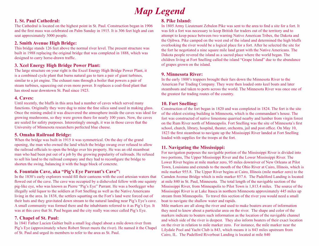
Map Legend1. St. Paul Cathedral:The Cathedral is located on the highest point in St. Paul. Construction began in 1906 and the first mass was celebrated on Palm Sunday in 1915. It is 306 feet high and can seat approximately 3000 people.
2. Smith Avenue High Bridge:This bridge stands 126 feet above the normal river level. The present structure wasbuilt in 1988 replacing the original bridge that was completed in 1888, which wasdesigned to carry horse-drawn traffic.
3. Xcel Energy High Bridge Power Plant:The large structure on your right is the Excel Energy High Bridge Power Plant, itis a combined cycle plant that burns natural gas to turn a pair of giant turbines,similar to a jet engine. The exhaust runs through a boiler that powers a pair ofsteam turbines, squeezing out even more power. It replaces a coal-fired plant thathas stood near downtown St. Paul since 1923.
4. Caves:Until recently, the bluffs in this area had a number of caves which served manyfunctions. Originally they were dug to mine the fine silica sand used in making glass.Once the mining ended it was discovered the atmosphere inside the caves was ideal forgrowing mushrooms, so they were grown there for nearly 100 years. Now, the cavesare sealed for safety purposes. Interestingly enough, it was in those caves that theUniversity of Minnesota researchers perfected blue cheese.
5. Omaha Railroad Bridge:When the bridge was built in 1915 it was symmetrical. On the day of the grandopening, the man who owned the land which the bridge swung over refused to allowthe railroad officials to open the bridge over his property. He was an old steamboatman who had been put out of a job by the growing popularity of railroads. He refusedto sell his land to the railroad company and they had to reconfigure the bridge toshorten the swing, balancing it with the huge block of concrete.
6. Fountain Cave, aka “Pig’s Eye Parrant’s Cave”:In the 1830’s early explorers would fill their canteens with the cool artesian waters thatflowed out of the cave. The cave was occupied by a disheveled fellow with one squintypig-like eye, who was known as Pierre “Pig’s Eye” Parrant. He was a bootlegger whoillegally sold liquor to the soldiers at Fort Snelling as well as the Native Americansliving in the area. In 1838, the settlers squatting on the Fort’s land were forced out oftheir huts and they gravitated down stream to the natural landing near Pig’s Eye’s cave.A small community was formed there and the inhabitants referred to it as Pig’s Eye. Itwas at this cave that St. Paul began and the city really was once called Pig’s Eye.
7. Chapel of St. Paul:In 1841 Father Lucien Galtier built a small log chapel about a mile down river fromPig’s Eye (approximately where Robert Street meets the river). He named it the Chapelof St. Paul and urged its members to refer to the area as St. Paul.
8. Pike Island:In 1805 Army Lieutenant Zebulon Pike was sent to the area to find a site for a fort. Itwas felt a fort was necessary to keep British fur traders out of the territory and toattempt to keep peace between two warring Native American Tribes, the Dakota andthe Ojibwa. Pike camped on the west end of the island and determined the high bluffsoverlooking the river would be a logical place for a fort. After he selected the site forthe fort he negotiated a nine square mile land grant with the Native Americans. TheDakota people revered the island as a sacred place where the world began. Thechildren living at Fort Snelling called the island “Grape Island” due to the abundanceof grapes grown on the island.
9. Minnesota River:In the early 1800’s trappers brought their furs down the Minnesota River to theAmerican Fur Trading Company. They were then loaded onto keel boats and latersteamboats and taken to ports across the world. The Minnesota River was once one ofthe greatest fur trading routes of the country.
10. Fort Snelling:Construction of the fort began in 1820 and was completed in 1824. The fort is the siteof the oldest existing building in Minnesota, which is the commandant’s house. Thefort was constructed of native limestone quarried nearby and lumber from virgin foreston the Rum River north of Minneapolis. Fort Snelling was the site of Minnesota’s firstschool, church, library, hospital, theater, orchestra, jail and post office. On May 10,1823 the first steamboat to navigate up the Mississippi River landed at Fort Snellingloaded with supplies for the troops at the fort.
11. Navigating the Mississippi:For navigation purposes the navigable portion of the Mississippi River is divided intotwo portions, The Upper Mississippi River and the Lower Mississippi River. TheLower River begins at mile marker zero, 95 miles downriver of New Orleans at PilotTown, Louisiana and extends to the mouth of the Ohio River at Cairo, Illinois, which ismile marker 955.8. The Upper River begins at Cairo, Illinois (mile marker zero) to theCamden Avenue Bridge which is mile marker 857.6. The Padelford Landing is locatedat mile 840 in St. Paul, Minnesota. The total length of the navigable section of theMississippi River, from Minneapolis to Pilot Town is 1,813.4 miles. The source of theMississippi River is at Lake Itasca in northern Minnesota approximately 445 miles upstream from Minneapolis. To travel this section of the river you would need a smallboat to navigate the shallow water and rapids.Mile markers are all along the river and used to make boaters aware of informationthey need to know about a particular area on the river. The shape and color of themarkers indicate to boaters such information as the location of the navigable channeland which side of the river is deepest. They also inform boaters of their exact locationon the river in relation to mile marker zero. For instance, the mile marker near theLilydale Pool and Yacht Club is 843, which means it is 843 miles upstream fromCairo, IL. The Padelford Riverboat Landing is located at mile 840