The Collective-A Study for Alternative Ways of Living-Nazanin Mehrin
Upload
nazanin-hemmatiCategory
view
765download
0description

A research on feasibility of polycentric development in Tehran Metropolitan Region
P1 Presentation Nazanin Babaee Hemmati 4119959
Graduation project, MSC 3 Urbanism
Faculty of Architecture, TU Delft
Date: 3.11.2011
From Regional Disparity to Regional Synergy

Outline of the presentation
Introduction
Presenting the Context
Problem Statement
Government’s Vision
Aim and Research Questions
Methodology and Timeline
Introduction Presenting the Context Problem Statement Aim & Research Question Government’s Vision Methodology & Timeline
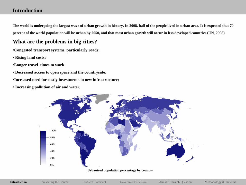
Introduction
The world is undergoing the largest wave of urban growth in history. In 2008, half of the people lived in urban area. It is expected that 70
percent of the world population will be urban by 2050, and that most urban growth will occur in less developed countries (UN, 2008).
What are the problems in big cities?
•Congested transport systems, particularly roads;
• Rising land costs;
•Longer travel times to work
• Decreased access to open space and the countryside;
•Increased need for costly investments in new infrastructure;
• Increasing pollution of air and water.
Urbanized population percentage by country

Introduction Presenting the Context Problem Statement Aim & Research Question Government’s Vision Methodology & Timeline
Location
Iran
Tehran Metropolitan Region (TMR)
City of Tehran
The most populated city in Iran and the center of cultural, economical, political
and social activities.
Area: 730 km-sq
Population: 9.10.347
One of the largest cities in Western Asia, and is the world’s 19th largest city.

Introduction Presenting the Context Problem Statement Aim & Research Question Government’s Vision Methodology & Timeline
Tehran Metropolitan Region (TMR)
With roughly 13.4 million people, TMR is Western Asia’s largest Metropolitan Region. The
TMR is divided into 9 urban areas and 17 districts, encompassing Greater Tehran city and Karaj
and their surrounding suburbs. Hosting one seventh of Iran’s population, the region extends over
a surface of 1247 square kilo-meters (491.9 square miles).

Introduction Presenting the Context Problem Statement Aim & Research Question Government’s Vision Methodology & Timeline
Geographical Situation
The city, however, cannot expand along the plain in the south, due to the high levels of Ground water and the arid zone , nor can the city expand along
the northern and eastern heights. So the city can only expand in the western direction due to its suitable geographical condition.
Alborz mountains in the North of the metropolis
Photo by Younes Kolahduz
Topography of Tehran province (2006)
Source: Atlas of Tehran Metropolis
Tehran in 1985 and 2009
Source: NASA Earth Observatory
Introduction Presenting the Context Problem Statement Aim & Research Question Government’s Vision Methodology & Timeline
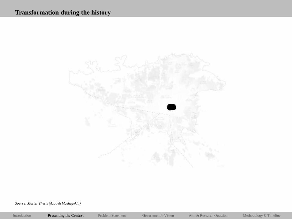
Transformation during the history
Source: Master Thesis (Azadeh Mashayekhi)

Introduction Presenting the Context Problem Statement Aim & Research Question Government’s Vision Methodology & Timeline
Regional Growth
Source: Zebardast, 2010

Introduction Presenting the Context Problem Statement Aim & Research Question Government’s Vision Methodology & Timeline
TMR (Current Situation)
What we have now?
Scattered urban structure in the metropolitan fringe with especial concentration near the infrastructure

Introduction Presenting the Context Problem Statement Aim & Research Question Government’s Vision Methodology & Timeline
Where People Live?
Greater Tehran is home to more than 68 percent of the regional population, while Karaj accommodated 10 percent and other urban areas cover other
10 percent of the TMR population. The remaining 22 percent live in the metropolitan periphery.
68%
10%
12%
10%
TMR population distribution
Tehran
Karaj
TMR fringe
TMR other cities
TMR Density
Source: Master Thesis (Azadeh Mashayekhi)

Introduction Presenting the Context Problem Statement Aim & Research Question Government’s Vision Methodology & Timeline
0
10
20
30
40
50
60
70
80
90
100
1966 1976 1986 1991 1996
Sh
are
of
Po
pu
lati
on
(P
erce
nt)
Year
Tehran City TMF
Where People Live?
The demographic processes in the Tehran Metropolitan Region (TMR) during the past three decades of 1966-1996 reveal that the
population of the TMR has grown from 3.13 million in 1966 to about 10.34 million in 1996. During this period, the share of the Tehran
City population has decreased from 87% in 1966 to about 65.5% in 1996 while the population of the rest of the TMR has grown from
14.2 % in 1966 to about 34.67% in 1996 .
Source: Zebardast, 2010

Introduction Presenting the Context Problem Statement Aim & Research Question Government’s Vision Methodology & Timeline
Where People Live?
Population density around the city of Tehran (2006) Source: Atlas of Tehran Metropolis
Limiting the City Boundary:
The government policy in order to limit the population growth
was restricting development between the 5 and 25yr
boundaries. This policy resulted to the increase of land and
property price in Tehran, accelerate spread of
development into the Tehran urban fringe. Land became
so scarce within that boundary and land prices got so high that
private developers started to build, some illegally, on land in
the restricted zone between the S- and 25-yr boundaries.

Introduction Presenting the Context Problem Statement Aim & Research Question Government’s Vision Methodology & Timeline
Where People Live?
0
200000
400000
600000
800000
1000000
1200000
1400000
1600000
Growth of the Settlements in the metropolitan fringe
1956 1966 1976 1986 1996 2006

Introduction Presenting the Context Problem Statement Aim & Research Question Government’s Vision Methodology & Timeline
Where People Work?
Areas with the greatest concentration of the low income people in the village around the city of Tehran (2006)
Source: Atlas of Tehran Metropolis
Tehran is the commercial heart of Iran. Tehran province has over 17,000 industrial units employing 390,000 people, 26% of all units in Iran.
The province contains 30% of Iran’s economy, and comprises 40% of Iran’s consumer market.

Introduction Presenting the Context Problem Statement Aim & Research Question Government’s Vision Methodology & Timeline
Where People Work?
TMR has an unequal distribution of workplaces, heavily skewed in favor of Tehran, and its business and financial centre in the City of Tehran.
• Around 62 percent (about 2.6 million) of all regional workers, work in Tehran.
• Karaj the other big city in TMR has 12 percent of the workers.
• The remaining of 26 percent is working in the surrounding urban areas.
Areas with the greatest concentration of the low income people in the village around the city of Tehran (2006)
Source: Atlas of Tehran Metropolis
Tehran is the commercial heart of Iran. Tehran province has over 17,000 industrial units employing 390,000 people, 26% of all units in Iran.
The province contains 30% of Iran’s economy, and comprises 40% of Iran’s consumer market.
62% 12%
26%
TMR labors distribution
Tehran
Karaj
TMR periphery

Introduction Presenting the Context Problem Statement Aim & Research Question Government’s Vision Methodology & Timeline
Economy
2%
37%
61%
Agriculture
Industry
Service
61 percent: banking, finance, insurance and business
services sectors.
37 percent: industrial activities, manufacturing and
construction.
2 percent: agriculture sector.

Introduction Presenting the Context Problem Statement Aim & Research Question Government’s Vision Methodology & Timeline
Industries
2%
37%
61%
Agriculture
Industry
Service
61 percent: banking, finance, insurance and business
services sectors.
37 percent: industrial activities, manufacturing and
construction.
2 percent: agriculture sector.
Iran’s Industrial Decentralization Policies (1973)
A number of major urban centers were identified by the policy as growth centers within which to concentrate major national investments. They were to attract
large-scale and private enterprises away from Tehran;
• to constitute a system of secondary cities;
• to absorb the surplus population of Tehran;
• to narrow the gap between rural and urban areas in terms of their access to social and commercial services. (Zebardast, 1990)

Introduction Presenting the Context Problem Statement Aim & Research Question Government’s Vision Methodology & Timeline
Infrastructure
Commuting is characteristics of urban life in Tehran, which makes Tehran’s downtown overcrowded during the day time and nearly empty at night.
Number of inner city daily travel: 15 million
Travel by public transportation: 48%
Travel by private car: 52%
Source: Master Thesis (Azadeh Mashayekhi)

Introduction Presenting the Context Problem Statement Aim & Research Question Government’s Vision Methodology & Timeline
Infrastructure
Commuting is characteristics of urban life in Tehran, which makes Tehran’s downtown overcrowded during the day time and nearly empty at night.
Number of inner city daily travel: 15 million
Travel by public transportation: 48%
Travel by private car: 52%
52%
22%
16%
5% 5%
Transportation in TMR
Private car and motorcycle
Public taxi
Bus
Minibus
Metro
Source: Master Thesis (Azadeh Mashayekhi)

Introduction Presenting the Context Problem Statement Aim & Research Question Government’s Vision Methodology & Timeline
Road Network (Current Situation)
In TMR due to the concentration of over 13 million residents without a large effective public transportation network, automobile has easily found its
place at the first stage in the Traffic and Transportation Network. (Tehran municipality official website)

Introduction Presenting the Context Problem Statement Aim & Research Question Government’s Vision Methodology & Timeline
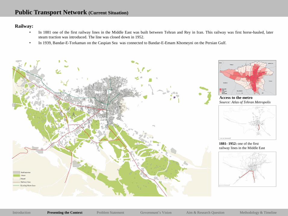
Public Transport Network (Current Situation)
Metro Line:
• In 2001 a metro system that had been in planning since the 1970s opened the first two of seven envisaged lines.
Access to the metro Source: Atlas of Tehran Metropolis
Introduction Presenting the Context Problem Statement Aim & Research Question Government’s Vision Methodology & Timeline
Public Transport Network (Current Situation)
Railway:
• In 1881 one of the first railway lines in the Middle East was built between Tehran and Rey in Iran. This railway was first horse-hauled, later
steam traction was introduced. The line was closed down in 1952.
• In 1939, Bandar-E-Torkaman on the Caspian Sea was connected to Bandar-E-Emam Khomeyni on the Persian Gulf.
1881- 1952: one of the first
railway lines in the Middle East
Access to the metro Source: Atlas of Tehran Metropolis
Introduction Presenting the Context Problem Statement Aim & Research Question Government’s Vision Methodology & Timeline
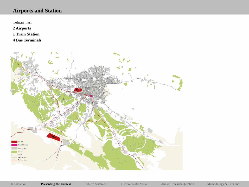
Airports and Station
Tehran has:
2 Airports
1 Train Station
4 Bus Terminals

Introduction Presenting the Context Problem Statement Aim & Research Question Government’s Vision Methodology & Timeline
Airports and Station
Tehran has:
2 Airports
1 Train Station
4 Bus Terminals
Imam Khomeini International Airport
Mehrabad National Airport
Central Station of Tehran

Introduction Presenting the Context Problem Statement Aim & Research Question Government’s Vision Methodology & Timeline
Problem Statement
1. City of Tehran was formed around CBD
2. Boom of growth due to the: High birth rate;
Migration from all over the country to the capital as an economic core of the country;
3. Limited the city boundary
Surplus population forced to live in the satellite town in the metropolitan fringe due to
their economic condition
4. Metropolitan fringe start to grow…
5. Marginalized area in the metropolitan fringe connected to parent city by road
network for they daily needs.
Introduction Presenting the Context Problem Statement Aim & Research Question Government’s Vision Methodology & Timeline
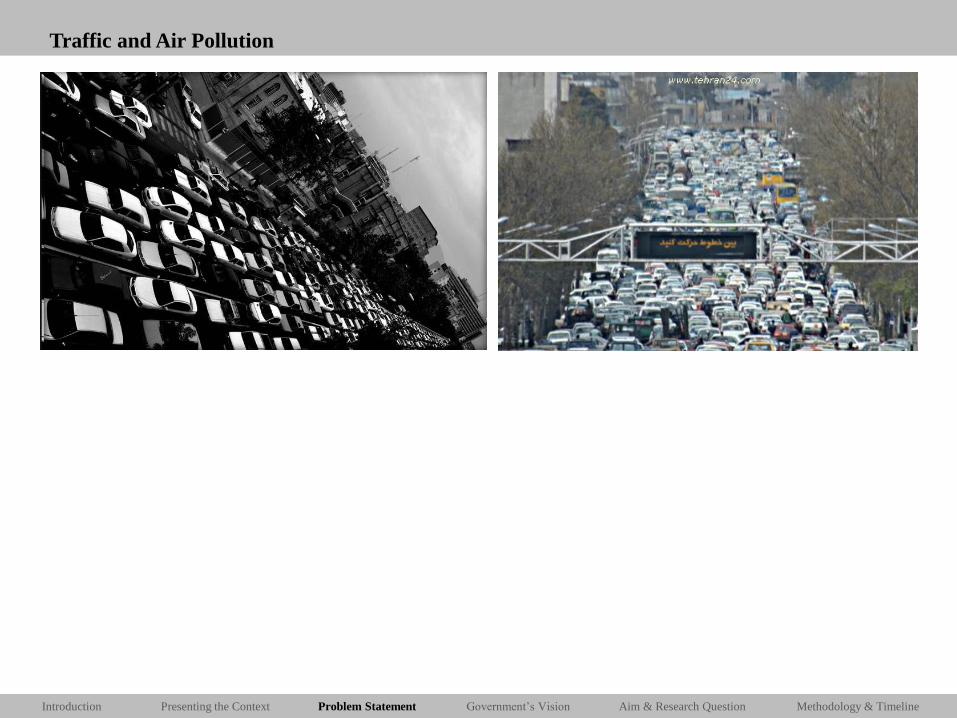
Traffic and Air Pollution

Introduction Presenting the Context Problem Statement Aim & Research Question Government’s Vision Methodology & Timeline
Traffic and Air Pollution

Introduction Presenting the Context Problem Statement Aim & Research Question Government’s Vision Methodology & Timeline
Unfair Life condition

Introduction Presenting the Context Problem Statement Aim & Research Question Government’s Vision Methodology & Timeline
Unfair Life condition

Introduction Presenting the Context Problem Statement Aim & Research Question Government’s Vision Methodology & Timeline
Monotonous Landscape

Introduction Presenting the Context Problem Statement Aim & Research Question Government’s Vision Methodology & Timeline
Monotonous Landscape
Source: Master Thesis (Azadeh Mashayekhi)

Introduction Presenting the Context Problem Statement Aim & Research Question Government’s Vision Methodology & Timeline
Monotonous Landscape
Rapid urbanization growth
+
Lack of regional planning and management

Introduction Presenting the Context Problem Statement Aim & Research Question Government’s Vision Methodology & Timeline
First Master Plan of Tehran 1966
The first Comprehensive Plan of Tehran, drawn up by the Californian architect Victor Gruen in 1963–67, with an agenda to expand
the metropolis was propounded.
Gruen in Tehran’s comprehensive-plan used a linear version of Howard’s concept. He envisioned a city divided into ten large and
fairly self-contained districts of 500,000 inhabitants linked to one another through a network of freeways and a rapid
transportation system and surrounded by open spaces with a very low population density. The commercial facilities would be
concentrated around the public transportation system. The master plan emphasized the idea of decentralization.
Source: Master Thesis (Azadeh Mashayekhi)

Introduction Presenting the Context Problem Statement Aim & Research Question Government’s Vision Methodology & Timeline
New Centrality
The plan for the new centrality is the extension of the historical core of the Tehran in the both direction of the
North and South.
Source: Municipality of Tehran
Introduction Presenting the Context Problem Statement Aim & Research Question Government’s Vision Methodology & Timeline
Vision for the TMR
Preparation of Tehran Metropolitan (Region) Plan:
Started in about January 1996 and the plan was finished in 1999. The process of plan examination and approval took more than 3
years. The plan was approved by the Cabinet in 2003.
The proposed population of the TMR in the year 2020 would be about 17.8 million people.
The proposed physical development pattern is polycentric, and the proposed strategies include the
following:
• Decentralization and De-concentration from the city of Tehran and devolution of responsibilities to
lower level authorities.
• Optimum utilization of existing infrastructure and utilities.
• Strengthening the role and expansion of existing New Towns. (Zebardast, 2010)

Introduction Presenting the Context Problem Statement Aim & Research Question Government’s Vision Methodology & Timeline
Vision of the Physical Structure of TMR
Source: Zebardast, 2010

Introduction Presenting the Context Problem Statement Aim & Research Question Government’s Vision Methodology & Timeline
Vision of the Road Networks of TMR

Introduction Presenting the Context Problem Statement Aim & Research Question Government’s Vision Methodology & Timeline
Vision of the Metro Line of TMR

Introduction Presenting the Context Problem Statement Aim & Research Question Government’s Vision Methodology & Timeline
Aim of the Project
Problem
Aim

Introduction Presenting the Context Problem Statement Aim & Research Question Government’s Vision Methodology & Timeline
Research Questions
To what extent the concept of polycentrism which is proposed by the
government is feasible for Tehran Metropolitan region (TMR)????

Introduction Presenting the Context Problem Statement Aim & Research Question Government’s Vision Methodology & Timeline
Sub-Research Questions
• What is a suitable definition of polycentrism for the context of Iranian Metropolitan Region?
• Why polycentrism is a suitable model for the TMR?
• What are the trends in TMR?
• How does Tehran Metropolitan Region responding to Change from mono-centric region to polycentric one?
• How has government sought to encourage or discourage the polycentrism in the TMR, through urban plan and policies?
• What are the urban planning recommendations for the TMR to deal with polycentric development?

Introduction Presenting the Context Problem Statement Aim & Research Question Government’s Vision Methodology & Timeline
Methodology

Introduction Presenting the Context Problem Statement Aim & Research Question Government’s Vision Methodology & Timeline
Timeline and Phasing

Thank you Questions and Recommendations?