Overview of the ESPAS project · 2 ESPAS is the infrastructure that facilitates access to...
46
Overview of the ESPAS project Anna Belehaki Research Director, National Observatory of Athens Scientific Manager of the ESPAS project 1
Transcript of Overview of the ESPAS project · 2 ESPAS is the infrastructure that facilitates access to...
Overview of the ESPAS project
Anna Belehaki
Research Director, National Observatory of Athens
Scientific Manager of the ESPAS project
1

2
ESPAS is the infrastructure that facilitates access to near-Earth data
Why there is a need to facilitate the access?
Heterogeneous data formats
Different distribution policies
Search in different web portals to query data from different instruments
In several cases data exist but are not archived
Difficulty to identify if specific data sets exist actually for the specific time period of interest
ESPAS rationale

3
Near Earth space: from the middle atmosphere up to the outer radiation belts
image credit: NASA

4
Space observatories in the near-Earth space
image credit: smdepo.org

5
Ground-based instruments observing the near-Earth space
GNSS receivers Magnetometers
Incoherent Scatter Radars
SuperDARN
Digisondes

6
Data assimilation into models
image credit: CCMC
EISCAT ISRs
Ne
Ne profiles from
ionosondes and
Digisondes
extrapolated to
the topside
ionosphere
CHAMP Radio
occultation
profiles
IRI Ne as
background
IMAGE RPI Ne
profiles
ISIS I&II and
Alouette topside
Ne profiles

7
What needs to access ED data from various sources?
EISCAT ISRs Ne
Ne profiles from ionosondes and Digisondes extrapolated to the topside ionosphere
CHAMP Radio occultation profiles
IRI Ne for background values
IMAGE RPI Ne profiles
ISIS and Alouette topside Ne profiles
Madrigal DB http://www.openmadrigal.org/
DIDB ionograms scaled characteristic http://giro.uml.edu/didbase/scaled.php
CHAMP Radio occultation profiles http://sisko.colorado.edu/sutton/data.html.
International Reference Ionosphere – IRI http://www.irimodel.org
IMAGE RPI Ne profiles http://ulcar.uml.edu/rpi.html
ISIS and Alouette topside data http://nssdc.gsfc.nasa.gov/space/isis/isis-status.html

8
Validation of a 3D electron density model
Reconstructed
ED profiles
along various
paths (vertical
and slant)
TaD electron density model Comparison with vertical and slant TEC
from IGS GNSS receivers

9
What needs to access the required data?
Download the TaD model computed TEC values http://dias.space.noa.gr
Grids of TEC values
Download IGS RINEX files for selected GNSS receivers https://igscb.jpl.nasa.gov/components/data.html
Convert RINEX to TEC TEC values for selected geographic locations
Extract model TEC for selected locations

10
NEMEC ET AL.: QUASI-PERIODIC EMISSIONS by CLUSTER and DEMETER spacecraft (JGR, 2013)
Frequency-time spectrograms of power spectral density of electric field fluctuations measured by DEMETER on 13 April 2010.
Frequency-time spectrograms of power spectral density of electric field fluctuations measured by the WBD instrument on board Cluster 4 on 13 April 2010 close to the equatorial region at radial distances 3 to 6 Re.
The extent of the analyzed QP event from 13 April 2010 as observed by DEMETER (black), Cluster 2 (red), and Cluster 4 (blue). L-values and MLTs of the satellites between 04:30 UT and 09:30 UT are plotted in polar coordinates. The parts of the satellite orbits where QP emissions were observed are plotted in bold.
Cluster satellites are in a highly elliptic orbit which is evolved with time. Demeter’s orbit is a quasi Sun-synchronous circular orbit with an inclination of about 98.23° and an altitude of about 660 km.

11
What needs to access CLUSTER and DEMETER data?
Demeter CDPP
Satellite Situation Center Web http://sscweb.gsfc.nasa.gov/
Find time intervals when CLUSTER and DEMETER data are available
Register and login
Download datafiles and quick plots
Cluster Science Archive
Automatic login
Download datafiles and quick plots
Proceed with data analysis

12
IMAGE RPI conjunctions with ground-based Digisondes (Belehaki et al 2009)
2D electron density distribution in the magnetic meridional plane derived from RPI data. When IMAGE plane is close to a Digisonde location on the ground (star symbol), the ionogram-derived bottomside vertical EDP of ionosphere can be combined with the plasmaspheric vertical EDP from RPI data (dashed line) for comparison with a reconstruction model (TaD model in this case).

13
Steps required to access and collect the data
IMAGE RPI Ne profiles IMAGE RPI Ne profiles http://ulcar.uml.edu/rpi.html
Manually search for conjunctions of RPI sounding location with ground-based Digisondes
Locate the RPI plasmagraphs and reproduce the topside ED profiles

14
How ESPAS can improve
data discovery and data access?

ESPAS Goals
Integrated access to heterogeneous data on conditions in near-Earth
space: ionised & neutral upper atmosphere, magnetosphere, …
Encourage more systematic exploration of multi-point measurements
in this region - homogeneous interfaces to diverse data
15
ESPAS e-
services
ESPAS
Users
Network
Support for modelling:
Cross comparison
Validation
Data assimilation
Extensible to new datasets
Link wider global community

16
22 providers, representing 40+ Open
Access repositories across Europe,
span a wide range of expertise that
22 providers, representing 40+ Open
Access repositories across Europe,
span a wide range of expertise that
is critical to ESPAS aims
Third party “partners”
bring in more data
ESPAS is built around an international
consortium of partners
LDI provides critical expertise, LDI provides critical expertise,
access to UML resources,
excellent links with European
partners

17
based
Ground-based
Ionospheric Radars: EISCAT ISRs, Mardigal DB, DIAS and GIRO Digisondes, Oblique data, Ionosondes (Tromsø, Gibilmanna, Sodankula, Hornsund), SuperDARN
GNSS Receivers SWACI and co-located with ionosondes
Magnetometer Data: Magnetic field data from INGV, SGO, DTU, IMAGE, TGO chains
FPI data Neutral wind and neutral temperature at 240 km
Space borne sensors Space borne sensors
CLUSTER, DEMETER NOAA/POESS CHAMP, GRACE FORMOSAT-3/COSMIC ISIS/Alouette IMAGE/PRI
MAGION-3
ACE
SOHO
PROBA2

Space Weather
Space Climate
Ionosphere
Magnetosphere
Thermosphere
18
Scientific Communities
Commercial Users Communities
Space Communications Satellite Operation Navigation and Surveillance
e-science developers

19
Samples of heterogeneous
data that ESPAS is going to provide
access

ESPAS basic services: Homogenized access to the main ESPAS data repositories
20
Observational Data • High level metadata search: Datasets • Granule level data search: Data
Search fields: organization, observatory, characteristics, instruments, temporal and spatial constraints, observed vs generated data
Madrigal Parameters
SAO Parameters

21
In the current ESPAS development phase, we put the emphasis on the interoperability of heterogeneous data sets
ESPAS should be regarded as an experimental platform for registration of datasets of different format from different instruments (ground-based and space born)
This exercise gives us the possibility to test the compatibility of the data model, the need to expand further the ontology, the functionality of the workflows, the layout of the web portal, the help and tutorial material
Your contribution to assess the system during this week will be extremely valuable
ESPAS status and the purpose of the training school

ESPAS services
22
•Metadata search Time period Assets Observed properties Observation collections Location (of the instrument)
•Download of data files: the user gets the available datafiles in their original format
•Download of data values (extracted parameters), the user gets as a result a text file (csv or XML format)
•Plotting tools: Downloaded data values can be plotted using either the quick plot of the
ESPAS platform or the most advanced IDL-based plotting tool for OGC data files.
•Registration and validation of data: Data collections from space missions and ground-based instruments can be registered in ESPAS following the standards of the ESPAS data model and domain ontology. The service is available to the scientific community upon request.

23
General Architecture
Semantic Harmonization Layer: harmonization of the data sources and their adoption of the ESPAS data model; Data and Semantic Integration Layer: (meta)data harvesting and basic content management services; Value-added Services Layer: provides the services built on; Web Layer : Graphical User Interface; Binding Layer : components that glue, manage and organize all the services in a SOA

ESPAS Interoperability
24
Liaise with related infrastructures Europe: HELIO, CASSIS,
Europlanet U.S.: NASA/HDMC, NSF/VSTO
Domain Reviews Consolidate state-of-the-art knowledge
Use cases Existing data & metadata
Existing standards
Define review framework Decide strategy on data model
Depth of metadata required Critical outputs needed
Output formats
Build ESPAS data model
Build ontology Interoperate with OGC and SPASE -
type models Link e-Sci and domain expertise
Test throughout!!!
iteration is important
Generic e-Science inputs Geospatial tools (e.g., OGC, GeoSciML)
Ontology tools (e.g., OWL, Protégé)
Domain Inputs SPASE data model
UKSSDC data dictionary Major data systems (CAA, DIAS, ODI, …)
Models (MSIS, CTIP, …) Domain standards
Coordinate systems
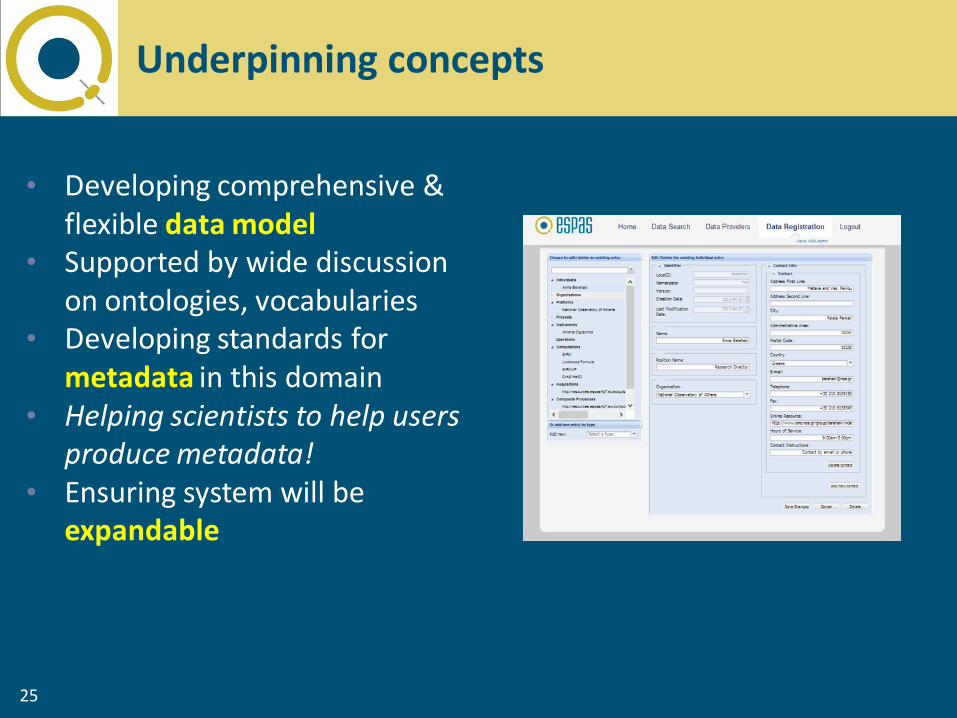
25
• Developing comprehensive & flexible data model
• Supported by wide discussion on ontologies, vocabularies
• Developing standards for metadata in this domain
• Helping scientists to help users produce metadata!
• Ensuring system will be expandable
Underpinning concepts

The logical process behind the XML schemas
'Acquisition' metadata “what was observed on 11/12/2012?” Observations Observations Observations Based on ISO 19156
“Observations & Measurements” Profiled for ESPAS
'Static' metadata
Observation
Collections Organisations Individual Instruments Platforms Based on ISO
19115 metadata
Vocabularies a.k.a. “the ontology” Defined
Terms and relationships (SKOS/RDF) Machine
readable, agreed semantics
Linked resources – using the web as infrastructure

27
ESPAS data model – high level overview

28
Relationship between Observation, Observed Property, and Process Capability

29
ESPAS ontology
ESPAS space physics ontology:
controlled vocabularies ESPAS vocabularies that
support the data model

30
Phenomenon vocabulary

31
Measurand vocabulary

32
Example of ESPAS ontology

33
Interoperability services
• An OGC compliant
Catalogue Service
(CSW), which supports the
discovery of ESPAS
resources offered by each
data provider.
• A Download Service, that
facilitates the download of
data bundles in terms of
data collections offered by
each provider.
• An OGC Compliant
Sensor Observation
Service (SOS) with the
goal to facilitate the
collection of selected data
parameters/values from
the observations of each
data provider.

34
http://www.espas-fp7.eu

35
ESPAS portal

36
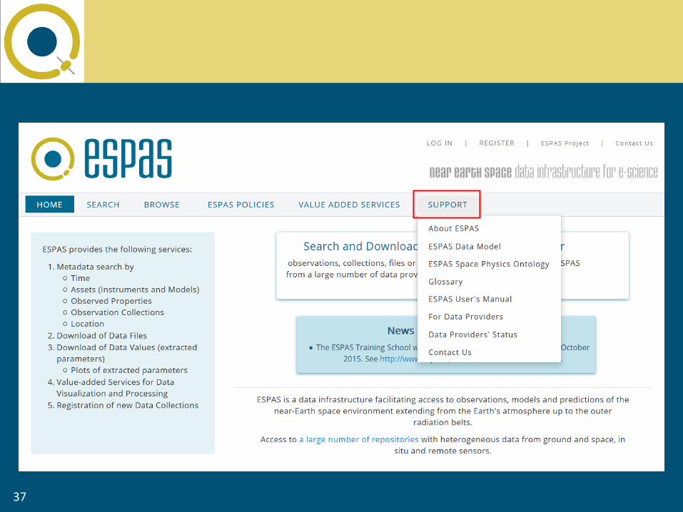
37

38

39

40

41
Iterative development involving community feedback
System
Developers
System Requirements
(Data Providers/ESPAS
Users)
Data Model
Development ESPAS
Releases
ESPAS community
feedback

42
IPR and policy issues
INTELLECTUAL PROPERTY RIGHTS
Joint ownership of foreground
Access Rights to Background
Access Rights to Foreground
Transfer of the Foreground
Publications
Logos, Names, Trademarks

43
ESPAS offers open access to data
Users must register
Users must accept the Terms of Reference provided by each data provider
Access policy – data reuse

44
Data license and Terms of Reference: an example
UBIRM's Terms of Reference The data acquired from this service may be used freely for educational and non-commercial academic research purposes by registered users only. Redistribution of the data is subject to the same conditions of use. Please reference: Angling, M. J., and N. K. Jackson-Booth (2011), A short note on the assimilation of collocated and concurrent GPS and ionosonde data into the Electron Density Assimilative Model, Radio Sci, 46(RS0D13).

Community Building Developments
Assessment of the ESPAS services; Specification of new
services
45
ESPAS long-term plans
Technical Developments
Robustness and expandability
ESPAS Sustainability Based on partners commitment
and financial viability

46
Thank you for your attention
http://www.espas-fp7.eu
Any QUESTIONS??