
Outline Code of Construction Practice - Planning Inspectorate... · significant infrastructure...
35
Outline Code of Construction Practice PINS Document Reference: 12.4 APFP Regulation 5(2)(a) January 2015
Transcript of Outline Code of Construction Practice - Planning Inspectorate... · significant infrastructure...

Outline Code of Construction Practice
PINS Document Reference: 12.4
APFP Regulation 5(2)(a)
January 2015

sdf
i
SMart Wind Limited
Hornsea Offshore Wind Farm
Project Two
Outline Code of Construction Practice
SMart Wind Limited
11th Floor
140 London Wall
London
EC2Y 5DN
Tel 0207 7765500
Email [email protected]
Copyright © 2015
All pre-existing rights reserved.
Liability
This report has been prepared by RPS Group Plc (RPS), with all reasonable skill, care and diligence within the terms of their contracts with SMart Wind Ltd or their subcontractor to RPS placed under RPS’ contract with SMart Wind Ltd as the case may be.
Document release and authorisation record
PINS document reference 12.4
Report Number UK06-050200-REP-0018
Date January 2015
Company name SMart Wind Limited

sdf
ii
Table of Contents
1 Introduction .......................................................................................................................... 1
1.1 General ................................................................................................................. 1
1.2 Purpose and Application of the Code ................................................................... 1
2 General provisions ............................................................................................................... 2
2.1 Construction Principles ......................................................................................... 2
2.2 Environmental Management ................................................................................. 2
2.3 Health and Safety Principles ................................................................................. 2
2.4 Local Community Liaison ...................................................................................... 2
2.5 Construction Programme and Implementation of the Code .................................. 2
3 General site operations ........................................................................................................ 6
3.1 Working Hours ...................................................................................................... 6
3.2 General Site Layout and Good Housekeeping ...................................................... 6
3.3 Screening and Fencing ......................................................................................... 6
3.4 Lighting ................................................................................................................. 6
3.5 Site Security .......................................................................................................... 7
3.6 Pest Control .......................................................................................................... 7
3.7 Emergency Planning and Procedures................................................................... 7
3.8 Communication Plan ............................................................................................. 7
3.9 Crane Arcs ............................................................................................................ 7
3.10 Clearance of Site on Completion .......................................................................... 7
4 Management of environmental issues ................................................................................. 8
4.2 Onshore ................................................................................................................ 8
4.3 Offshore .............................................................................................................. 21
References ............................................................................................................................... 27
Appendix A Regulatory Framework ...................................................................................... 28

sdf
iii
Glossary
Term Definition
Designated site An area afforded protection under an International Convention, European Directive or a piece of UK legislation due to its nature, conservation or landscape value.
Development Consent Order (DCO)
A legal order granting development consent for one or more nationally significant infrastructure projects.
EIA Regulations
A collective name for the various statutory instruments through which the EIA Directive has been implemented in the UK and in the context of this document, the Infrastructure Planning (Environmental Impact Assessment) Regulations 2009 (as amended).
Environment Agency (EA)
The EA is a non-departmental public body of the Department for Environment Food and Rural Affairs and an Assembly Government Sponsored Body of the Welsh Government that serves England and Wales.
Flood Zone 1 This zone comprises land assessed as having a less than 1 in 1,000 annual probability of river or sea flooding (<0.1%).
Helicopter Main Route (HMR)
Routes which are established to facilitate safe helicopter flights in Instrument Flight Rules (IFR) conditions (i.e. when flight cannot be completed in visual conditions).
Hoarding
A fencing system used to enclose a building site whilst construction takes place. They are typically solid (made from timber, metal or composite panels) and have vehicular and/or pedestrian access points.
Onshore Fisheries Liaison Officer (OFLO)
Fisheries Liaison Officer based onshore with the role of keeping local and international fishermen informed of on-going work within the area, including marine surveys.
Overarching National Policy Statement for Energy (NPS EN-1)
A document setting out national policy against which proposals for major energy projects will be assessed and decided on.
Permeability A measure of the ability of a material (such as rock) to transmit fluids (liquids or gases).
Porosity A porous material contains voids such as pores, joints or fissures within a solid framework or matrix. The voids allow fluids (liquids or gases) to move through the material.
Principal aquifer
Layers of rock or drift deposits that have a high inter-granular and/or fracture permeability - meaning they usually provide a high level of water storage. They may support water supply and/or river base flow on a strategic scale. In most cases, principal aquifers are aquifers previously designated as major aquifers.
Term Definition
Putrescible waste Solid waste that contains organic materials (such as food waste) capable of being decomposed by microorganisms.
Secondary A aquifer
Permeable layers of rock or drift deposit capable of supporting water supplies at a local rather than strategic scale, and in some cases forming an important source of base flow to rivers. These are generally aquifers formerly classified as minor aquifers..
Secondary B aquifer
Predominantly lower permeability layers, which may store and yield limited amounts of groundwater due to localised features such as fissures, thin permeable horizons and weathering. These are generally the water-bearing parts of the former non-aquifers.
Scour Erosion holes around the foundations of offshore wind turbines and infrastructure created by tidal currents.
Southern North Sea Offshore Wind Forum (SNSOWF)
A group comprising representatives from Dogger Bank, Hornsea and East Anglia Round 3 Zones, was established in 2011 to share and discuss information on agreed topics in relation to cumulative impacts of development and to provide a meaningful forum for cross dissemination of information, thinking and ideas relevant to cumulative impacts.
Strategic Flood Risk Assessment
A Strategic Flood Risk Assessment looks at flood risk at a strategic level on a local planning authority scale.
Waste Hierarchy Principle
A classification of waste management options in order of their environmental impact.
Acronyms
Acronym Full term
AEZ Archaeological Exclusion Zone
BGL Below Ground Level
CDM Construction (Design and Management) Regulations 2007
CoCP Code of Construction Practice
COLREGs Convention on International Regulations for Preventing Collisions at Sea
cSAC Candidate SAC
DB Drainage Board
DCO Development Consent Order
DIO Defence Infrastructure Organisation
EA Environment Agency
sdf
iv
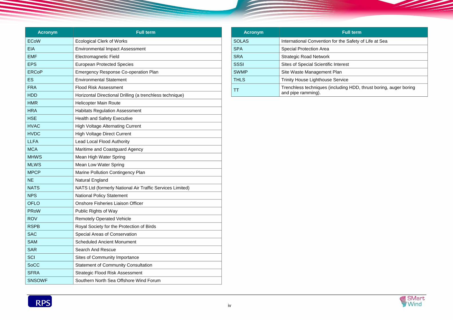
Acronym Full term
ECoW Ecological Clerk of Works
EIA Environmental Impact Assessment
EMF Electromagnetic Field
EPS European Protected Species
ERCoP Emergency Response Co-operation Plan
ES Environmental Statement
FRA Flood Risk Assessment
HDD Horizontal Directional Drilling (a trenchless technique)
HMR Helicopter Main Route
HRA Habitats Regulation Assessment
HSE Health and Safety Executive
HVAC High Voltage Alternating Current
HVDC High Voltage Direct Current
LLFA Lead Local Flood Authority
MCA Maritime and Coastguard Agency
MHWS Mean High Water Spring
MLWS Mean Low Water Spring
MPCP Marine Pollution Contingency Plan
NE Natural England
NATS NATS Ltd (formerly National Air Traffic Services Limited)
NPS National Policy Statement
OFLO Onshore Fisheries Liaison Officer
PRoW Public Rights of Way
ROV Remotely Operated Vehicle
RSPB Royal Society for the Protection of Birds
SAC Special Areas of Conservation
SAM Scheduled Ancient Monument
SAR Search And Rescue
SCI Sites of Community Importance
SoCC Statement of Community Consultation
SFRA Strategic Flood Risk Assessment
SNSOWF Southern North Sea Offshore Wind Forum
Acronym Full term
SOLAS International Convention for the Safety of Life at Sea
SPA Special Protection Area
SRA Strategic Road Network
SSSI Sites of Special Scientific Interest
SWMP Site Waste Management Plan
THLS Trinity House Lighthouse Service
TT Trenchless techniques (including HDD, thrust boring, auger boring and pipe ramming).

sdf
1
This Outline Code of Construction Practice (CoCP) forms part of the suite of 1.1.1
documents to accompany an planning application to the Planning Inspectorate
(PINS) for a Development Consent Order (DCO) for Project Two.
Project Two is the second project proposed for development within the Hornsea 1.1.2
Zone. The Hornsea Zone is being developed using a phased programme, which
divides the zone into subzones. The first of the subzones to be developed was
Subzone 1 (Project One), which was granted development consent by the Secretary
of State for Energy and Climate Change in December 2014. Subzone 2 (Project Two)
is the second of the subzones to be developed. Project Two is similar in terms of its
nature and location, to that of Project One.
The application for development consent for Project Two is being compiled and 1.1.3
consulted on by SMart Wind on behalf of ‘the Developer’.
The CoCP sets out the management measures that the Developer and its contractors 1.2.1
will be required to adopt and implement for all construction activities on Project Two.
These measures have been identified during the design of the onshore and offshore
elements of the Project as part of the Environmental Impact Assessment (EIA)
process. They include strategies, control measures and monitoring procedures for
managing the potential environmental impacts of constructing the wind farm and
limiting disturbance from construction activities as far as reasonably practicable. It
covers the environmental and public health and safety aspects of the construction
phase of the project that may affect the interests of local residents, businesses, the
general public and other sensitive receptors in the vicinity of the construction sites
(see paragraph 1.2.2 for information on "construction sites").
The CoCP will apply to all construction works carried out at Project Two. The onshore 1.2.2
works comprise:
Landfall at Horseshoe Point;
Cable route (approximately 40 km);
A new onshore High Voltage Direct Current (HVDC) converter/High Voltage
Alternating Current (HVAC) substation at Killingholme; and
Connection to the existing National Grid substation at Killingholme.
The offshore works comprise: 1.2.3
Offshore array (including construction of the foundations and the turbines);
Inter-array, platform interconnector and accommodation platform power cables;
Accommodation platforms (including construction of the foundations);
HVDC converter station(s)/HVAC collector substation(s) and HVAC reactive
compensation substation(s); and
Offshore export route (approximately 115 km).
The term 'construction' in the CoCP includes all site preparation, demolition, material 1.2.4
delivery, excavated material disposal, waste removal, and all related engineering and
construction activities as authorised by the DCO.
The provisions of this CoCP will be incorporated into the contracts for the 1.2.5
construction of all works authorised by the DCO. All contractors, subcontractors and
their suppliers will be required to observe the relevant provisions of the CoCP.
Commitments to follow good practice during operation will be set out in a Project
Environmental Management and Monitoring Plan, a Contaminated Land and
Groundwater Scheme, the Outline Ecological Management Plan (SMart Wind, 2014a)
and the Outline Landscape Scheme and Management Plan (SMart Wind, 2014b)
which will be implemented on completion of the construction period.
The CoCP incorporates legislative requirements, current standards and best practice 1.2.6
measures to define the standards of construction practice that contractors will be
required to adopt and implement. The CoCP will be monitored as part of the
Developer’s Health, Safety and Environmental Management System (HSE MS).
However, compliance with this CoCP will not absolve the Developer, contactor or
subcontractors from compliance with all legislation and byelaws relating to their
construction activities.

sdf
2
Project Two will be constructed in an environmentally sensitive manner and will meet 2.1.1
the requirements of all relevant legislation, codes of practice and standards as
identified in the Environmental Statement (ES) and limit the adverse impacts on the
local community and environment as far as reasonably practicable.
Project Two will be built, where reasonably practicable, in accordance with current 2.2.1
best practice for minimising the adverse effects of construction on the environment
and the local community.
The developer will review the environmental performance of the main construction 2.2.2
contractors as part of the tender selection process.
Appropriate industry standards will be adopted and implemented for the health, safety 2.3.1
and welfare of the construction staff on Project Two and arrangements will be in
place for the discharge of duties under the Construction (Design and Management)
Regulations 2007 (currently being revised).
Once the main roles of the construction team are assigned, the Principal Contractors 2.3.2
for onshore and offshore works will develop a Health and Safety Plan to address the
safety of construction workers, visitors to the site and the general public. The Health
and Safety Plan will set out how all health and safety risks are identified and
managed in accordance with legal requirements and current best practice.
Prior to commencing main construction activities (e.g. earthworks) occupiers of 2.4.1
premises in the vicinity of the work will be notified of the nature of the proposed works
and be provided with contact details to which any enquiries should be directed.
The Developer will establish a system for dealing with enquiries or complaints from 2.4.2
the public, local authorities or statutory consultees (see Communication Plan in
section 3.8 of this CoCP). Any complaints that may arise will be logged, reported and
addressed. Complaints will be investigated and where required, mitigation will be
implemented. A complaint close-out report will be provided to the Local Planning
Authority within an agreed timescale.
Construction work is proposed to commence in 2017. Project Two could be built in a 2.5.1
single phase of construction or up to four phases. In a multiphase construction
scenario, gaps of time could occur between the completion of certain tasks and those
tasks being resumed for subsequent phases (see Volume 1, Chapter 3: Project
Description). This approach is based on the following assumptions:
the onshore construction programme, including all phases and gaps between
phases, will be completed within five and a half years from the start of onshore
construction;
works in the intertidal area will occur only during the April to September period for
up to five sequential years. Construction in the intertidal area may take place in up
to four phases. In the event of a phased construction, the first phase would
comprise the installation of up to eight ducts by trenchless methods under the sea
defence which may spread over a maximum periods of three years; and
the offshore construction, including all phases and gaps between phases, will be
completed within six years from the start of offshore construction.
The CoCP will be implemented across all phases of the onshore and offshore 2.5.2
construction programme through the following documents:
Onshore
Construction method statement to include;
Details of cable corridor construction, crossing techniques, management of
top soil and sub soil from cable corridor and HVDC converter/HVAC
substation; and
Details of contractors, plant and equipment and associated works.
Communications Plan to include;
A framework for engaging stakeholders (i.e., identifying who may be affected
by construction impacts, methods of contacting and engaging with affected
groups, methods of providing advance notifications);
Roles and responsibilities for implementing the communication plan; and
Complaints procedure.

sdf
3
Dust Management and Monitoring Plan to include;
Measures to monitor and reduce dust from construction activities.
Outline Landscape Scheme and Management Plan to include:
The design and management objectives of the landscape scheme for existing
and proposed vegetation;
Planting specification including planting mixes for the onshore HVDC
converter/HVAC substation; and
Post construction monitoring
Outline Ecological Management Plan to include;
Designated sites and habitats and protected species;
Mitigation measures to be implemented during pre-construction, construction
and post construction;
Long term management of habitats and protected species;
Monitoring and reporting requirements; and
Implementation timetable.
Construction Traffic Management Plan to include;
Measures to manage construction traffic;
Locations of wheel wash facilities, welfare facilities etc,
Fixed routes for construction traffic; and
Delivery timings and restrictions.
Travel Plan to include measures to encourage sustainable travel for the
construction workforce.
Surface Water Drainage Scheme to include;
Detailed surface water drainage scheme based on sustainable drainage
principles to ensure that runoff rates to the surrounding water environment are
maintained at pre-development 1 in 1 year runoff rates at the onshore HVDC
converter/HVAC substation, and monitoring to ensure that the agreed rate of
discharge is maintained; and
An assessment of the hydrological and hydrogeological context of the onshore
HVDC converter/HVAC substation.
Written Scheme to deal with Contamination of Land to include;
An investigation and assessment report to identify the extent of any
contamination and the remedial measures to be taken for that stage to render
the land fit for its intended purpose; and
A management plan which sets out long-term measures with respect to any
contaminants remaining on the site.
Pollution Control Plan to include:
Details of the containment of fuels, oils, lubricants and chemicals;
Measures to protect surface and groundwater during construction;
Emergency procedures in cases of spillages or leaks.
Landfill Gas Monitoring Plan to include;
Monitoring strategy, locations and reporting.
Written Scheme for Noise Management and Monitoring Measures to include;
Best Practicable Means to manage and monitor noise levels.
Written Scheme of Investigation (WSI) to include:
The scope of work to be undertaken to mitigate those direct physical impacts
on the historic environment above Mean High Water Spring (MHWS) such as
○ Completion of archaeological evaluation (trial trenching etc.,) where
required;
○ Targeted archaeological excavations at locations where archaeological
remains are known to exist;
○ Archaeological watching brief during topsoil stripping; and
○ Reinstatement of earthwork features such as ridge and furrow.
Port Traffic Management Plan to include:
Details of the onshore port-related traffic to and from the selected base port or
ports for construction and/or operation of the relevant part of the authorised
development.
Site Waste Management Plan to include;
Estimates of the types and quantities of waste likely to be generated during
construction;
Sustainable waste management measures; and
General targets to divert waste from landfill.
Materials Storage Plan to include:
Designated areas for storage of oils and lubricants; and
Design of impermeable storage areas.
Employment and Skills Plan;
External Lighting Scheme; and
Screening and Fencing Plan.
Offshore
Construction and monitoring programme to include:
The proposed construction start date;

sdf
4
The proposed timings for mobilisation of plant, delivery of materials and
installation works; and
Proposed pre-construction surveys, baseline report format and content,
construction monitoring, post construction monitoring and related reporting.
Construction method statement to include;
Details of foundation, turbine, offshore accommodation platforms, offshore
substation and circuit installation including any seabed preparation, scour
protection and drilling and disposal of arisings methods; and
Details of contractors, vessels and associated works.
Cable specification and installation plan to include:
The technical specification of offshore electrical circuits, including a desk-
based assessment of attenuation of electro-magnetic field strengths, shielding
and cable burial depth;
A detailed cable laying plan, including geotechnical data, cable laying
techniques and a cable burial risk assessment encompassing the identification
of any cable protection which exceeds 5% of navigable depth referenced to
Chart Datum and, in the event that any area of cable protection exceeding 5%
of navigable depth is identified, details of any steps to be taken to ensure
existing and future safe navigation is not compromised;
Details of the steps to be taken, where the offshore electrical circuits across
the inter tidal zone are buried using trenching or ploughing to ensure that the
excavation and subsequent backfilling is carried out in such a way as to
maintain the sediment profile so far as is reasonably practicable to do so; and
Details of the steps to be taken, where the offshore electrical circuits across
the inter tidal zone are installed using the horizontal directional drilling method.
Project Environmental Management and Monitoring Plan (PEMMP) to include:
A marine pollution contingency plan to address the risks, methods and
procedures to deal with any spills and collusion incidents during construction
and operation of the authorised scheme;
A chemical risk analysis to include information regarding how and when
chemicals are to be used, stored and transported;
A disposal plan including details of disposal site monitoring;
Waste management and disposal arrangements;
Offshore project maintenance plans;
Locations of any Archaeological Exclusion Zones (AEZs) agreed as part of the
Written Scheme of Investigation;
Any seasonal restrictions on construction works; and
The appointment and responsibilities of a Fisheries Liaison Officer (FLO) and
an Environmental Liaison Officer and, where appropriate, an intertidal
ecological clerk of works.
Scour protection management and cable armouring plan to include:
Details of the need, type, sources, quantity, location and installation methods
for scour protection and cable armouring.
Marine Mammal Mitigation Protocol (MMMP) in the event that driven or part-driven
pile foundations are proposed to be used to include:
Identification of a Marine Mammal Monitoring Zone (MMMZ);
Appointment of an appropriate number of suitably qualified marine mammal
observer(s);
Methods for the detection of marine mammals within the MMMZ whether
visually (by the marine mammal observer(s)) or acoustically using Passive
Acoustic Monitoring equipment or other means of detection;
A reporting methodology to enable efficient communication between the
marine mammal observer(s) and the person responsible for approving
commencement of piling;
An appropriate soft start procedure whereby piling activities do not commence
until an agreed time has elapsed and during which marine mammals have not
been detected within the MMMZ; and
Where appropriate, methods for the application of acoustic deterrent devices.
Written Scheme of Archaeological Investigation to include:
Details of the responsibilities of the undertaker, archaeological consultant and
contractor;
A methodology for any further site investigation;
Analysis and reporting of survey data;
Delivery of any mitigation including, where necessary, archaeological
exclusion zones;
Monitoring during and post construction, including a conservation programme
for finds;
Archiving of archaeological material; and
Reporting and recording protocol, including reporting of any wreck or wreck
material during construction, operation and decommissioning of the
authorised scheme.
Marine Mammal Monitoring Plan to include:
The circumstances in which marine mammal monitoring will be required; and
The monitoring to be carried out in such circumstances.
Proposed survey and reinstatement plan for Salicornia forming Annex 1 Habitat in
respect of the foreshore connection to include:
The circumstances in which reinstatement will be required; and
The proposed methods of reinstatement .
An offshore project maintenance plan, to include:

sdf
5
details of offshore electrical circuit maintenance;
Emergency Response and Co-operation Plan to include:
Full details of the emergency co-operation plans for the construction,
operation and decommissioning phases in accordance with the MCA
recommendations contained within MGN 371 “Offshore Renewable Energy
installations (OREIs) – Guidance on UK Navigational Practice, Safety and
Emergency response Issues”.
Training and Competence
All levels of site personnel will have responsibility for minimising the risks to the 2.5.3
environment from the activities on site, and steps will be taken by the Principal
Contractor to make them aware of these duties and the environmental requirements
of the CoCP. Contractors will be required to operate induction schemes for all
personnel to ensure that they are aware of their individual responsibility to comply
with the CoCP.
Contractors will be responsible for employing an appropriately qualified workforce 2.5.4
and for identifying the training needs of their personnel.

sdf
6
Offshore
The construction of offshore turbines and transmission infrastructure is scheduled to 3.1.1
take place 24 hours a day throughout the year subject to weather conditions.
Construction in the marine environment is potentially hazardous and it will be in the
interests of safe working to take advantage of as much construction time in
favourable conditions as is possible.
Onshore
Working hours will be agreed with the Local Planning Authority. The proposed 3.1.2
construction working hours for the onshore elements are as follows:
Monday to Friday: 07:00 - 18:00 hours;
Saturday: 07:00 - 13:00 hours; and
Sunday or Bank Holidays: no working.
In certain circumstances, specific works may have to be undertaken outside the 3.1.3
normal working hours including:
Horizontal Directional Drilling (HDD) or other trenchless construction operations
which may require 24 hour machinery operation, dependent on the ground
conditions;
Oil filling of transformers at the onshore substation;
Remedial works, for example in the event of severe weather;
Jointing operations along the cable route; and
Security of sites and protection of open assets.
A good housekeeping policy will be applied to the construction areas at all times. As 3.2.1
far as reasonably practicable the following principles will be applied:
All working areas will be kept in a clean and tidy condition;
The site will be secured to prevent unauthorised access;
Wheel washing facilities will be cleaned frequently;
Open fires will be prohibited at all times;
All necessary measures will be taken to minimise the risk of fire and the contractor
will comply with the requirements of the local fire authority;
Adequate welfare facilities will be provided for construction staff;
Waste from the construction areas will be stored securely to prevent wind blow;
and
Waste will be removed at frequent intervals.
Temporary construction compounds will be required close to the onshore cable route 3.2.2
for the storage of materials, assembly of large items of plant and parking of mobile
plant and vehicles. Within these areas, material and plant storage will be located to
limit adverse environmental effects where practicable. The possible location of the
compounds is shown on the crossing schedule of Volume 4, Annex 4.3.4: Onshore
Crossing Schedule.
Secure temporary fencing will be installed around the construction compounds. 3.3.1
Temporary fencing will also be provided for sections of the cable route as
appropriate. The type of fencing will be selected to suit the location and purpose and
will be agreed with the Local Planning Authority post consent. All boundary
fences/screens will be maintained in a tidy condition and will be fit for purpose.
All construction areas will remain securely fenced at all times during construction. All 3.3.2
temporary screening and fencing will be removed as soon as reasonably practicable
after completion of the works.
External lighting of the construction site will be designed and positioned to: 3.4.1
Provide the necessary levels for safe working;
Minimise light spillage or pollution; and
Avoid disturbance to adjoining residents and occupiers.
The external lighting scheme will be agreed with the Local Planning Authority post-3.4.2
consent.

sdf
7
Construction compounds will be secured to minimise the opportunity for unauthorised 3.5.1
entry. Where possible, access to construction areas will be limited to specified entry
points and all personnel entries/exits will be recorded for security and health and
safety purposes.
The risk of pest/vermin infestation will be reduced by ensuring any putrescible waste 3.6.1
is stored appropriately and regularly collected from the construction areas, and
effective preventative pest control measures are implemented. Any pest infestation
will be dealt with promptly and notified to the Local Planning Authority as soon as
possible.
Emergency procedures will be developed for the onshore and offshore elements of 3.7.1
Project Two taking into account the anticipated hazards and the conditions at each
work site. The emergency response plans will include emergency pollution control
measures based on Environment Agency guidelines. Fire and safety, site evacuation,
and spill prevention and control procedures will also be developed. The emergency
procedure will contain emergency phone numbers and the method of notifying local
authorities and statutory authorities. The procedures will be displayed at the work
sites and all site staff will be required to follow them.
An emergency response plan will be developed for the onshore and offshore 3.7.2
construction phase. For construction works onshore, this will be the responsibility of
the Principal Contractor and all contractors and subcontractors will work in
accordance with this plan. For offshore works, the plan will take the form of an
Emergency Response Co-operation Plan (ERCoP). The Developer will be
responsible for preparing the plan, which will be in accordance with the requirements
of the deemed Marine Licences taking into consideration MGN 371 and MGN 372.
No development seaward of the Mean High Water Spring (MHWS) will commence
until the ERCoP has been agreed in writing by the Secretary of State in consultation
with the Maritime and Coastguard Agency (MCA).
Offshore contractors will be required to develop their own marine pollution 3.7.3
contingency plans (MPCP) and emergency response procedures, which will fall within
the framework of the PEMMP.
The Developer/Principal Contractor will implement a proactive approach to 3.8.1
communications. Occupiers of nearby properties and Local Planning Authorities will
be informed in advance of works taking place, (in particular, those affecting Public
Rights of Way and local roads) including the duration of the works.
A complaints procedure will be implemented during the construction process. 3.8.2
Complaints will be investigated and where required, mitigation will be implemented.
All calls will be logged and the response will be recorded.
Cranes will be operated in accordance with the requirements of BS 7121, Code of 3.9.1
Practice for Safe Use of Cranes.
Temporary construction compounds and accesses will be cleared as work 3.10.1
progresses and when they are no longer required. On completion of construction
work all plant, temporary buildings or vehicles will be removed.
Following completion of the onshore cable installation, the working area will be 3.10.2
reinstated to its previous condition. This will include:
Reinstatement of intertidal area;
Reinstatement of topsoil and subsoil, including loosening or ripping of compacted
soil;
Reinstatement of land drainage systems, where necessary post construction
drains may be installed, typically parallel to the cable route;
Reseeding of any fields of grassland, grass margins and ditch banks;
Reconstruction of any drains, ditches or roads crossed using an open cut method;
Replanting of any hedgerows or felled shrubs or trees as detailed in the Outline
Landscape Scheme and Management Plan (SMart Wind, 2014b) and through
consultation with the Local Planning Authority ;
Restoration or repair of fences, gates, tracks or hard standing; and
Reinstatement of PRoW where temporary diversions have been put in place
during construction.

sdf
8
This CoCP identifies objectives and management measures for onshore and offshore 4.1.1
environmental issues. It includes all relevant measures as identified in the mitigation
sections of the individual chapters of the Environmental Statement, to minimise
environmental impacts during construction.
Public Access and Transport Management
Objectives
To carry out construction works in such a way that maintains highway safety and 4.2.1
avoids adverse effects on local communities and highway users.
Management measures
Traffic management measures will be put in place to maintain access to the intertidal 4.2.2
area using the permissive footpath which runs along the top of the sea defences,
however there may be times when access is not possible.
A Construction Traffic Management Plan will be agreed with the Local Authority in 4.2.3
consultation with the relevant Highway Authority and the Highways Agency. The plan
will include:
the preferred route for abnormal loads (this will be between Immingham Docks
and the HVDC converter/HVAC substation or between the Strategic Road
Network (SRN) and the HVDC converter/HVAC substation);
the route timing and method of transport of abnormal loads (this will be discussed
and agreed with the Highways Authority, the police and relevant highways and
bridge authorities);
additional monitoring of HGV routes, time restrictions and pedestrian crossing
opportunities to identify potential severance. The CTMP will include details of
mitigation where necessary (e.g., temporary pedestrian crossings);
mitigation measures to manage construction traffic, including noise and vibration
from construction traffic; and
the location of welfare facilities.
A travel plan (or equivalent) for the construction workforce will also be developed and 4.2.4
implemented. The plan will include measures to encourage the use of sustainable
travel options by construction workers (e.g., car sharing).
A traffic management plan for the onshore port-related traffic (i.e., to and from the 4.2.5
selected base port or ports for construction) will be developed in consultation with the
relevant highway authority and relevant planning authority.
All HGV access points will be designed and constructed to meet appropriate visibility 4.2.6
and other highway standards and will be agreed with the relevant Highway
Authorities. Further details are provided in Volume 6, Annex 8.7.1: Transport
Assessment.
Video condition surveys will be undertaken before the start of the works and after the 4.2.7
substantial completion of works on minor links used by HGVs to access the cable
route. Damage to the highway caused by construction traffic will be repaired.
HGV movements, accidents and near misses on the section of the A18 between the 4.2.8
A46 and the B1203 will be monitored in order to identify whether there are any safety
deficiencies in the highway that could be worsened as a result of the increased level
of HGV traffic associated with the construction works. Mitigation measures will be
incorporated into the Construction Traffic Management Plan if necessary.
In relation to the use of the access road serving the HVDC converter/HVAC 4.2.9
substation from Chase Hill Road the following mitigation measures are proposed:
Protection will be provided for services under the access road where this is
necessary;
Measures will be implemented if necessary to maintain access at all times for
emergency vehicles during the delivery of abnormal loads;
A video survey of the condition of the access road and an assessment of the
condition of the highway drainage will be undertaken before and after the
construction of the HVDC converter/HVAC substation and an appropriate
contribution made towards the remediation of any damage resulting from the
passage of construction vehicles; and
Appropriate traffic management will be implemented in association with any works
to the access road to ensure that access for other users is maintained at all times.
Restrictions will be implemented on HGV operating hours, particularly through 4.2.10
Tetney, North Thoresby and along those sections of the B1210 that provide access to
local schools. Restrictions will also be implemented on HGV operating hours and
measures implemented to minimise the number of HGV movements through
sensitive areas when access to trenchless construction sites is essential (through
North Cotes, Aylesby Road and Top Road).
Measures will be implemented to minimise dust, mud and debris associated with the 4.2.11
movement of construction vehicles. This will include wheel washing at all site access
points where it is necessary to eliminate the risk of mud and debris on the highway.
Appropriate parking facilities will be provided. 4.2.12

sdf
9
Where possible overall vehicle movement generation will be minimised through 4.2.13
measures to encourage and promote sustainable travel and transport. Localised
management of vehicle movements will be undertaken to minimise the risks of
vehicles meeting each other on narrow sections.
Local management of vehicle movements will be implemented to minimise the risks 4.2.14
of vehicles meeting each other on narrow sections.
The design of HGV access points (including visibility standards) and where 4.2.15
necessary, temporary speed restrictions on the adjacent highway will be agreed with
the relevant Highway Authorities.
Traffic management measures will be implemented at those points where cable 4.2.16
trenches cut across highways or where existing access rights are affected to
minimise delays to existing highway users and to maintain highway safety.
At all vehicle accesses where accommodation works are undertaken to allow the 4.2.17
movement of vehicles between the cable route and the highway, the original highway
will be reinstated after construction work is completed.
The burial depth of cables in the vicinity of the proposed A160/A180 improvement 4.2.18
scheme will be increased to a level agreed with the Highways Agency (HA).
PRoW affected by the construction works will be diverted, with closures only when 4.2.19
absolutely necessary (see Volume 3, Chapter 7: Land Use, Agricuture and
Recreation).
Noise and Vibration
Objectives
To control and limit noise and vibration levels, so far as is reasonably practicable, to 4.2.20
minimise disturbance to sensitive receptors.
Management measures
Construction works will be undertaken in accordance with the best practicable means 4.2.21
(as defined in Section 72 of the Control of Pollution Act 1974), to minimise noise and
vibration effects. Noise control measures will be consistent with the recommendations
of the current version of BS 5228 'Code of Practice for Noise and Vibration Control
on Construction and Open Sites’ - Part 1: Noise and Part 2: Vibration' (BS 5228-
1:2009+A1:2014 and 2009) and include the following:
Best Practicable Means (e.g., the use of quieter alternative methods, plant and/or
equipment, where reasonably practicable, the use of site hoardings, enclosures,
portable screens and/or screening nosier items of plant, where reasonably
practicable; maintaining and operating all vehicles, plant and equipment in an
appropriate manner, to ensure that extraneous noise from mechanical vibration is
kept to a minimum); and
A Written Scheme for Noise Management and Monitoring Measures will be agreed
with the local authorities prior to the start of construction. Construction activities
will be carried out in accordance with the agreed Written Scheme for Noise
Management and Monitoring Measures.
Air Quality and Health
Objectives
To minimise the generation of nuisance dusts during construction and to facilitate 4.2.22
community engagement and a proactive approach to complaints regarding nuisance
dusts.
Management measures
Implementation of a Dust Management and Monitoring Plan (DMMP) to be approved 4.2.23
by the Local Authority. The level of detail will depend on the risk and should include
as a minimum, the ‘highly recommended’ measures in the IQAM guidance. The
‘desirable’ measures should be included as appropriate for the site. The DMMP will
include monitoring of dust deposition. ,
Communications
Develop and implement a stakeholder communications plan that includes
community engagement before work commences on site. The plan will display the
name and contact details of person(s) accountable for air quality and dust issues
on the site boundary (this may be the environment manager/engineer or the site
manager), and the head or regional office contact information.
Preparing and maintaining the site
The site layout will locate machinery and dust causing activities away from
sensitive receptors, as far as possible;
Solid screens or barriers will be erected around dusty activities or site boundary
that are at least as high as any stockpiles on site;
The site or specific operations will be fully enclosed where there is a high potential
for dust production and the site is active for an extended period;
Potentially dust-generating materials will be removed from site as soon as
possible, unless being re-used on site. If they are being re-used on site, the
stockpiles will be covered, seeded or fenced to prevent wind whipping;
Site runoff of water or mud will be avoided;
Bonfires and burning of waste on site will not be permitted; and
Site fencing, barriers and scaffolding will be kept clean. ;

sdf
10
Construction operations
Cutting, grinding and sawing equipment will be fitted with or used in conjunction
with suitable dust suppression techniques (such as water sprays or local
extraction);
Adequate water supply will be made available to enable effective dust/particulate
matter suppression. Non-potable water will be used where possible and
appropriate;
Enclosed chutes, conveyors and covered skips will be used where practicable;
Drop heights from conveyors, loading shovels, hoppers and other loading or
handling equipment will be minimised and fine water sprays on such equipment
where appropriate; and
Equipment to clean any dry spillages will be readily available. Spillages will be
cleaned up as soon as reasonably practicable after the event using wet cleaning
methods.
Earthworks
Earthworks and exposed areas/soil stockpiles will be re-vegetated as soon as
practicable. Hessian or mulches will be used where it is not possible to re-
vegetate or cover topsoil as soon as practicable. Cover will be removed only in
small areas during work and not all at once;
Sand and other aggregates will be stored in bunded areas and will not be allowed
to dry out unless this is required for a particular process, in which case appropriate
additional control will be put in place;
Bulk cement and other fine powder materials will be delivered in enclosed tankers
and stored in silos with suitable emission control systems to prevent escape of
material and overfilling during delivery;
Roughening up of concrete surfaces (scabbling) will be avoided;
Vehicles entering and leaving the site will be covered to prevent escape of
materials during transport;
Inspect on-site haul routes for integrity and instigate necessary repairs to the
surface as soon as practicable;
Record all inspections of haul routes and any subsequent action in a site log book;
Install hard surfaced haul routes which are regularly damped down with fixed or
mobile sprinkler systems , or mobile water bowsers and regularly cleaned;
Dry sweeping of large areas will be avoided; and
Where possible, dust generating activities will be programmed to avoid prolonged
dry or windy weather conditions.
Operating machinery and site vehicles
All vehicle engines will be switched off when stationary;
Where possible, mains electricity or battery powered equipment will be used
instead of diesel or petrol powered equipment/generators;
A maximum speed limit will be imposed for construction vehicles of 15 mph on
surfaced roads and 10 mph on un-surfaced haul roads and work areas. If long
haul routes are required these speeds may be increased with suitable additional
control measures provided, subject to the agreements of the local authority, where
appropriate;
Water-assisted dust sweeper(s) will be used on the access and local roads to
remove, as soon as practicable, any material tracked out of the site;
A wheel washing system (with rumble grids to dislodge accumulated dust and
mud) will be implemented. An adequate area of hard standing will be provided
between the wheel wash facility and the site exit, wherever site size and layout
permits;
Access gates will be located at least 10 m from receptors where possible;
A logistics plan will be prepared as part of the construction traffic management
plan to manage the sustainable delivery of construction goods and materials; and
As far as practicable a travel plan (or equivalent) will be implemented that
supports and encourages sustainable staff travel (public transport, cycling, walking
and car-sharing).
Site management and monitoring
Record all dust and air quality complaints, identify cause(s), take appropriate
measures to reduce emissions in a timely manner, and record the measures
taken. Make the complaints log available to the Local Planning Authority when
asked;
Haul routes will be inspected and necessary repairs will be instigated as soon as
practicable. Details of inspections and any action taken will be recorded in a site
log book;
Exceptional incidents that cause dust and/or air emissions either on- or off-site will
be recorded in the log book together with the action taken to resolve the situation.
Liaison with other high risk construction sites within 500 m of the site boundary to
ensure that plans are co-ordinated and that dust/particulate matter emissions are
minimised;
Undertake daily on-site and off-site inspection, where receptors (including roads)
are nearby, to monitor dust, record inspection results, and make the log available
to the Local Planning Authority when asked. This should include dust soiling

sdf
11
checks of surfaces such as street furniture, cars and window sills within 100 m of
the site boundary;
When activities with a high potential to produce dust are being carried out and
during prolonged dry or windy conditions increase the frequency of inspections;
and
Carry out regular site inspections to monitor compliance with the DMMP and
agree continuous monitoring locations with the Local Authority..
Protection of the Water Environment
Objectives
To minimise the risk of surface water flooding during the construction phase, to 4.2.24
prevent pollution of surface watercourses and to minimise the impact on local surface
water features.
Management measures
A written scheme dealing with contamination of land and groundwater will be 4.2.25
submitted to and approved by the Local Planning Authority prior to authorised
development commencing.
A detailed surface water drainage scheme based on sustainable drainage principles 4.2.26
will be developed and implemented and an assessment of the hydrological and
hydrogeological context will be undertaken for the onshore HVDC converter/HVAC
substation site to ensure the run-off rates to the surrounding water environment are
maintained at pre development rates. Monitoring will be carried out to ensure that the
agreed rate of discharge is maintained.
Where the cable route crosses land drains and smaller watercourse crossings, the 4.2.27
construction side access will be installed over a pre-installed culvert of suitable size
to accommodate the water volumes and flows necessary or a temporary bridge will
be installed through agreement with the land owner, relevant Drainage Board (DB),
Lead Local Flood Authority (LLFA) or Environment Agency (EA). The construction
side access will be removed at the end of the construction programme. Where the
construction side access crosses existing underground services the use of temporary
metal roadway sections may be employed to distribute heavy loads and protect the
underlying services.
Cable entry and exit points within transition pits, bays and link boxes will be sealed 4.2.28
with an appropriate water proofing material to mitigate flood risk.
Any surface water flowing into the trenches during the construction period will be 4.2.29
pumped via settling tanks or ponds to remove sediment and potential contaminants,
before being discharged into local ditches or drains via temporary interceptor drains.
Where gradients on site are significant, cable trenches will include a hydraulic brake 4.2.30
(bentonite or natural clay seals) to reduce flow along trenches and hence reduce
local erosion.
Any field drainage intercepted during the cable installation will either be reinstated 4.2.31
following the installation of the cable or diverted to a secondary drain or channel. Any
works undertaken will be in agreement with the appropriate stakeholders.
Refuelling of machinery will be undertaken within designated areas where spillages 4.2.32
can be easily contained. Machinery will be routinely checked to ensure it is in good
working condition and should only be active when required.
Any tanks and associated pipe work containing oils and fuels will be double skinned 4.2.33
and be provided with intermediate leak detection equipment.
The following specific mitigation measures for the protection of surface and ground 4.2.34
water during construction will be implemented to ensure that the works meet the
requirements of the Water Framework Directive (WFD):
Management of construction works to comply with the necessary standards and
conditions identified by the EA;
As part of site induction site personnel will be briefed on the importance of water
quality, the location of watercourses and pollution prevention;
Areas with prevalent runoff to be identified and drainage actively managed, e.g.
through bunding and/or temporary drainage;
Areas at risk of spillage, such as vehicle maintenance areas and hazardous
substance stores (including fuel, oils and chemicals) to be bunded and carefully
sited to minimise the risk of hazardous substances entering the drainage system
or the local watercourses (e.g., no storage of oil within 50 m of a spring, well or
borehole or within 10 m of a watercourse, or within areas at risk of flooding).
Additionally the bunded areas will have impermeable bases to limit the potential
for migration of contaminants into groundwater following any leakage/spillage.
Bunds used to store fuel, oil etc to have a 110% capacity;
Avoidance of oil storage where oil could run over hard ground into a watercourse;
Used oils will be stored, transported and disposed of to a waste transfer station
licensed to handle hazardous wastes;
Excavated material to be placed in such a way as to avoid any disturbance of
areas near to the banks of watercourses and any spillage into the watercourses;
Construction materials to be managed in such a way as to effectively minimise the
risk posed to the aquatic environment;
Intrusive investigations to be undertaken to establish the standoff of trenching for
the cable route from the western boundary of Eastfield Road landfill and determine
the extent of the landfill containment;

sdf
12
A landfill gas monitoring plan will be developed and implemented during
construction along the cable route corridor west of Eastfield Road landfill;
Any residual gas from Eastfield Road landfill migrating into the trench will be
allowed to passively vent to avoid accumulation of gas in confined spaces. If gas
levels are sufficient to cause a health and safety concern, passive venting
between the landfill and cable trenches will be considered;
Any construction works with the potential to affect drainage will be constructed in
accordance with relevant statutory guidance and approved by the relevant DB,
Lead Local Flood Authority or EA prior to the commencement of construction;
No water will be discharged to any watercourse, public sewer or drain without the
consent of the person to whom it belongs;
Environmental permits will be obtained for discharges to surface watercourses
where required by the EA;
Wheel washers and dust suppression measures will be used as appropriate to
prevent the migration of pollutants;
The generation of silt and contaminated water will be reduced by minimising
disturbance of the watercourse banks and bed, and runoff from exposed ground
and stockpiles;
Deep trenchless excavations and deep excavations for pile foundations to be
mitigated by casing off perched groundwater units during construction works and
sealing off once the casing is removed;
The EA flood defence will be crossed utilising a trenchless technique which will
not directly impact on the defence and therefore will not affect flood risk. The
minimum depth between the underground cable conduits and the ground level at
the seaward toe of the defences will be 10 m;
An appropriately sized coffer dam or similar would be constructed around the
trenchless technique excavation on the landward side. The structure would be
designed to maintain the current standard of protection provided by the flood
defence and it will be agreed with the regulator;
Following installation of the ducts, both the ducts and the steel pipes beneath the
flood defence, will be sealed with an appropriate water proofing material to
maintain the integrity of the sea defences and to mitigate flood risk.
The ducts under the sea defences will always be capped to prevent sea water
passing through them at high tide. The only exception will be when the cables are
being pulled into the ducts and the caps must be removed. These works will be
undertaken in a way to maintain the integrity of the sea defences;;
Trenchless construction methods for onshore watercourse cable crossing points
will be a minimum of 2 m below the hard bed of the watercourse and at a
maximum depth of 15 m below ground level (BGL) subject to site investigation
confirming a suitable standoff above the Chalk principal aquifer. A minimum
standoff of 2 m above the Chalk aquifer is suggested. The depth of each individual
trenchless conduit will by determined by preliminary geotechnical surveys at each
site prior to construction to identify a suitable standoff above the Chalk principal
aquifer;
A hydrogeological risk assessment meeting the requirements of Groundwater
Protection and Principles in Practice (EA, November 2012) will be undertaken at
each trenchless conduit crossing location;
Measures will be implemented during cable trenching across the two Source
Protection Zone 1 areas to ensure that the principal aquifer is not affected directly
or indirectly (e.g. confirming the depth of the overlying clay). HVDC cabling will be
thermally insulated;
Measures will be implemented during cable trenching across areas with
secondary A or B perched aquifers to ensure the groundwater quality is not
adversely affected (as set out in the WFD) and that groundwater does not use the
trenches as a conduit. HVDC cabling will be thermally insulated;
Regular cleaning of roads of any construction waste and dirt will be carried out;
and
Consultation with the EA will be on-going throughout the construction period to
promote best practice and to improve proposed mitigation measures.
All construction work will be undertaken in accordance with good environmental 4.2.35
practice based on legal responsibilities and guidance in accordance with the general
overarching guidance on good environmental management including:
PPG1 (EA, 2013) and also more specific guidance in: CIRIA C648 (2006) Control
of Water Pollution from Linear Construction Projects;
EA et al (2014a) Pollution Prevention Guidance Note 6 (PPG6):– Working at
Construction and Demolition Sites;
EA et al (2014b) Pollution Prevention Guidance Note 5 (PPG5): – Works and
maintenance in or near water;
CIRIA (2001) C532 Control of Water Pollution from Construction Sites – Guidance
for Consultants and Contractors; and
CIRIA (2007) C607, The SUDS Manual.
Flood risk assessment
A Flood Risk Assessment (FRA) has been undertaken for the onshore HVDC 4.2.36
converter/HVAC substation in accordance with the guidance in the Overarching
National Policy Statement for Energy (NPS EN-1) and the FRA practice guidance on
flood risk assessment in the National Planning Policy Framework (NPPF) Technical
Guidance to which applicants are directed in NPS EN-1.

sdf
13
The proposed HVDC converter/HVAC substation is located in Flood Zone 1 (as 4.2.37
defined by EA flood maps and North East and North Lincolnshire Councils’ Strategic
Flood Risk Assessment (SFRA) (2010)). It has passed the Sequential Test
requirement for locating developments in ‘low’ flood risk zones. The access track is
shown to be located within the Councils’ SFRA defined Flood Zone 2/3(A).
Developments within Zone 2/3(A) require an emergency evacuation plan for staff
during extreme flood events. To meet this requirement, a procedure will be
implemented to ensure no site staff are present during an extreme event.
Following the construction of the proposed onshore HVDC converter/HVAC 4.2.38
substation there will be an increase in the amount of low permeability cover, and
surface runoff will need to be controlled at a rate to be agreed with the EA and North
East Lindsey DB. Refer to the FRA in Volume 6, Annex 6.2.3 for further information.
Land drainage will be restored to its existing condition. The location and method of 4.2.39
land drainage will be identified from a detailed drainage survey post-consent.
Ecology and Intertidal Ornithology
Objectives
To minimise the impact of construction works on protected species and designated 4.2.40
sites and to minimise the loss of nature conservation features such as hedgerows
and mature trees.
Management measures
A written ecological management plan will be submitted to and approved by the Local 4.2.41
Planning Authority prior to authorised development commencing above Mean Low
Water Spring (MLWS).
Designated sites
Measures will be implemented to minimise the impacts of construction on the 4.2.42
intertidal, coastal sand dunes and saltmarsh habitats of the Humber Estuary Special
Area of Conservation (SAC), Special Protection Area (SPA), Ramsar and Site of
Special Scientific Interest (SSSI) and Donna Nook National Nature Reserve (NNR) as
outlined in the Habitats Regulation Assessment (HRA).
A temporary bridge and/or culvert will be used to cross the drainage ditch behind the 4.2.43
sea defence and an access track will be run across the culvert and over the top of the
sea defence into the intertidal area. The track will then run parallel with the sea
defence in the intertidal zone to meet the intertidal construction corridor. Measures
will be put in place to minimise the impact of tracking vehicles on the sand dunes and
sea defence.
Protective buffer zones
Works-free protective buffer zones will be established around retained habitats of 4.2.44
ecology and nature conservation concern, namely woodland, mature broadleaved
trees and ponds, as well as sections of watercourses that will not be crossed by
open-cut trenching. These buffer zones will be maintained throughout the works
period.
Buffer zones surrounding retained areas of woodland and mature broadleaved trees 4.2.45
will be at least approximately 15 m in width or at least the width of the tree root
protection zone, as advised by an appropriately qualified surveyor. Where
practicable, buffer zones around hedgerows will be at least 5 m in width, and
surrounding ponds and watercourses will be at least 8 m in width, or 10 m in width for
main watercourses (i.e the. Louth Canal, Tetney Drain and Laceby Beck); approvals
will be obtained as necessary for works closer to channels and main watercourses
managed by Drainage Boards (DBs), Lead Local Flood Authorities (LLFA) and the
EA.
In the intertidal zone at the export cable landfall, works-free protective buffer zones 4.2.46
will be established around areas of continuous coastal saltmarsh (Atlantic salt
meadows) and intertidal cockle beds to prevent direct physical disturbance to these
habitats by anchor placement, vehicle movement or cable trenching. The buffer zone
will be delineated pre-construction using a hand held GPS and the coordinates of
these features will be provided to contractors to ensure anchor placements do not
occur in these areas.
All buffer zones will prohibit the tracking of heavy vehicles, and the storage of 4.2.47
vehicles, machinery, equipment and soils. All protective buffer zones will be
maintained throughout the construction phase. The ECoW will regularly (at least once
every two weeks) monitor adherence to the requirements of the buffer zones and will
maintain a record of all site checks undertaken and findings.
Coastal and inter tidal habitats
A pre-construction walkover survey of coastal and intertidal habitats at the export 4.2.48
cable landfall site will be undertaken in order to provide an up-to-date assessment
and delineation of the intertidal cockle beds and coastal saltmarsh habitats (i.e.
Atlantic salt meadows). The data collected will be used to inform the locations and
extents of works-free protection zones referred to above.
A pre-construction survey of the Salicornia species and other annuals colonising mud 4.2.49
and sand located within the intertidal cable convergence corridor will also be
undertaken. The exact scope of the survey will be developed in consultation with NE.
In order to encourage the capture of disturbed Salicornia seed in the intertidal 4.2.50
sediments, sediments in affected areas (i.e. in the intertidal convergence zone) will
be raked over to remove deep depressions (i.e. those with depths greater than 10

sdf
14
cm), such as wheel ruts or tracks. Although a small amount of texture is required to
encourage Salicornia seed capture, deeper depressions often become waterlogged
resulting in reduced colonisation in these areas. This will be undertaken following the
completion of all cable installation works at the end of each of the cable installation
phases (i.e. in September each year). Works will be overseen by the ECoW and an
ecological watching brief will be provided by the ECoW or appropriately experienced
ecologist pre-approved by the ECoW.
At the landfall the access road along the crest of the sea defences will not be used 4.2.51
during installation of the ducts and cables beneath the sea defences. The
construction vehicular side access routes are shown in Volume 4 Annex 4.3.4:
Onshore Crossing Schedule. The drain inland of the sea defences will be culverted
and the vehicle track will run across the culvert and over the top of the sea defences
and onto the intertidal area. The track will then run parallel with the sea defences in
the intertidal zone to meet the intertidal construction corridor. Measures will be set in
place to minimise the impact of tracking vehicles on the sand dunes and intertidal
zone.
Following completion of the cable installation works at the landfall, except in an 4.2.52
emergency, the access road along the crest of the sea defences will not be used until
a scheme for the protection of the sea defences from use of the access road during
the operation and maintenance of the project has been submitted to and approved in
writing by the EA.
Trees and Hedgerows
The length of hedgerow clearance for each hedgerow crossed by open-cut trenching 4.2.53
will be limited to no greater than 30 m. This will include any haul roads and buffer
zones, but will exclude soil storage areas, which will be sited at least 5 m from the
hedgerow.
Hedgerow clearance, including tree felling works, will be carried out in accordance 4.2.54
with species-specific requirements described below.
Where individual mature trees are to be felled, sections of dead or decaying wood will 4.2.55
be soft-felled (felled in sections) and, where practicable, will be relocated to suitable
locations as near to the source tree as practicable, as instructed by the Ecological
Clerk of Works (ECoW) (i.e., within areas of similar environmental conditions,
particularly with regard to shade and ground water-levels, and in locations that will
not obstruct the reinstatement of previous land management practices).
A works-free buffer zone of at least 15 m between mature hedgerow trees, or at least 4.2.56
equivalent to the root protection zone calculated on a tree-by-tree basis by an
appropriately qualified surveyor, and the adjacent cable trench will be set in place
where practicable. The cable trench will be located approximately 10 m from retained
hedgerows.
Arisings will be removed from site or will be temporarily relocated to a site more than 4.2.57
5 m from working areas (or 50 m if trenchless techniques are being undertaken) so
as to ensure that any nesting birds (or other species) which might utilise the pile of
cuttings are protected against likely impacts of construction.
All sections of hedgerow removed to enable construction of the cable route corridor, 4.2.58
will be replanted as soon as practicable after cable installation, with regard to
appropriate planting months. Replacement planting will comprise native shallow-
rooting hedgerow species typical of the area. To prevent future root damage to
cables, no hedgerow trees will be planted along the cable route. In addition,
enhancement planting to improve connectivity and/or native species diversity will be
undertaken within a 100 m wide corridor encompassing the cable route.
Enhancement planting will include the planting of native hedgerow trees, typical of
the area, at a suitable distance from the cable route.
A replanting programme will also be carried out at the proposed onshore HVDC 4.2.59
converter/HVAC substation site where hedgerow removal will be permanent. To
compensate for habitat loss and to provide screening. Where required, new
hedgerow planting will be protected by fencing until the hedgerow has become
established (see Outline Landscape Scheme and Management Plan.).
Habitat reinstatement in consultation with LPAs will involve the replacement following 4.2.60
cable installation, of stripped soils and the planting of native hedgerows, shrubs and
trees, typical of the local area and of local provenance where possible.
Replacement tree planting, on a one for one basis within hedgerows, of any trees 4.2.61
removed during the construction works.
Amphibians and reptiles
Amphibian exclusion and drift fencing will be installed along the outer edges of works 4.2.62
areas that fall within 250 m of a Great Crested Newt (GCN) pond as advised by an
ECoW. The exclusion fencing will be extended to segregate any other ponds located
within 250 m of the GCN pond and which also fall within 250 m of the working
corridor, providing there are no significant barriers to dispersal between ponds.
Where fence installation requires the clearance of habitat of potential value to 4.2.63
hibernating GCN (i.e. mature hedgerows or suitable piles of rubble and earth),
exclusion fencing will be installed outside the GCN hibernation period (considered to
be between November and January/mid-February, although dependent on local
weather conditions), so as to prevent the potential disturbance of hibernating GCNs.
The installation of amphibian exclusion fencing will be carried out under the guidance 4.2.64
of the ECoW and watching brief of a GCN licensed ecologist, pre-approved by the
ECoW, who will be present to capture and relocate any GCN disturbed in the process
to suitable habitat located outside the fenceline and with open access to nearby
ponds.
sdf
15
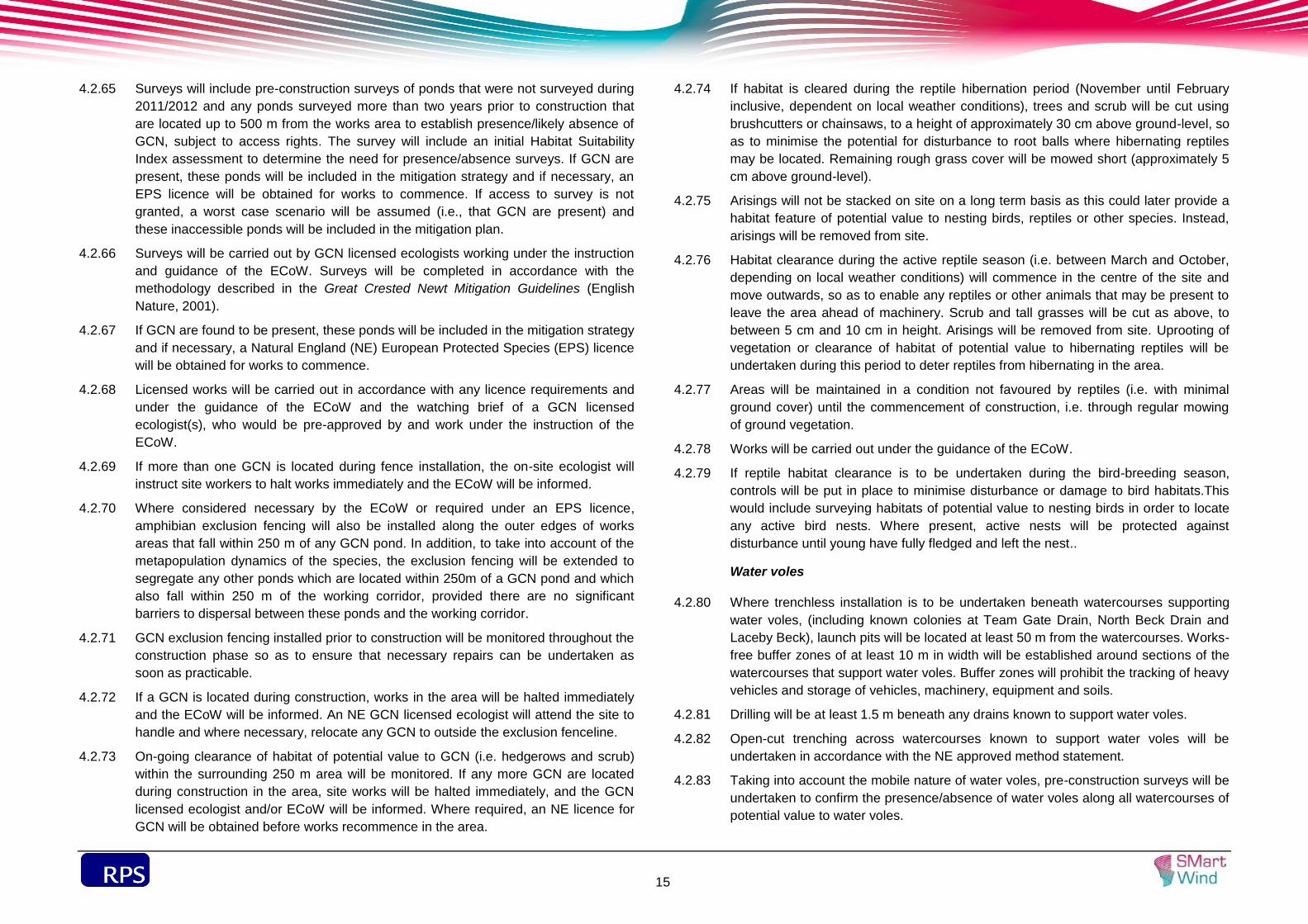
Surveys will include pre-construction surveys of ponds that were not surveyed during 4.2.65
2011/2012 and any ponds surveyed more than two years prior to construction that
are located up to 500 m from the works area to establish presence/likely absence of
GCN, subject to access rights. The survey will include an initial Habitat Suitability
Index assessment to determine the need for presence/absence surveys. If GCN are
present, these ponds will be included in the mitigation strategy and if necessary, an
EPS licence will be obtained for works to commence. If access to survey is not
granted, a worst case scenario will be assumed (i.e., that GCN are present) and
these inaccessible ponds will be included in the mitigation plan.
Surveys will be carried out by GCN licensed ecologists working under the instruction 4.2.66
and guidance of the ECoW. Surveys will be completed in accordance with the
methodology described in the Great Crested Newt Mitigation Guidelines (English
Nature, 2001).
If GCN are found to be present, these ponds will be included in the mitigation strategy 4.2.67
and if necessary, a Natural England (NE) European Protected Species (EPS) licence
will be obtained for works to commence.
Licensed works will be carried out in accordance with any licence requirements and 4.2.68
under the guidance of the ECoW and the watching brief of a GCN licensed
ecologist(s), who would be pre-approved by and work under the instruction of the
ECoW.
If more than one GCN is located during fence installation, the on-site ecologist will 4.2.69
instruct site workers to halt works immediately and the ECoW will be informed.
Where considered necessary by the ECoW or required under an EPS licence, 4.2.70
amphibian exclusion fencing will also be installed along the outer edges of works
areas that fall within 250 m of any GCN pond. In addition, to take into account of the
metapopulation dynamics of the species, the exclusion fencing will be extended to
segregate any other ponds which are located within 250m of a GCN pond and which
also fall within 250 m of the working corridor, provided there are no significant
barriers to dispersal between these ponds and the working corridor.
GCN exclusion fencing installed prior to construction will be monitored throughout the 4.2.71
construction phase so as to ensure that necessary repairs can be undertaken as
soon as practicable.
If a GCN is located during construction, works in the area will be halted immediately 4.2.72
and the ECoW will be informed. An NE GCN licensed ecologist will attend the site to
handle and where necessary, relocate any GCN to outside the exclusion fenceline.
On-going clearance of habitat of potential value to GCN (i.e. hedgerows and scrub) 4.2.73
within the surrounding 250 m area will be monitored. If any more GCN are located
during construction in the area, site works will be halted immediately, and the GCN
licensed ecologist and/or ECoW will be informed. Where required, an NE licence for
GCN will be obtained before works recommence in the area.
If habitat is cleared during the reptile hibernation period (November until February 4.2.74
inclusive, dependent on local weather conditions), trees and scrub will be cut using
brushcutters or chainsaws, to a height of approximately 30 cm above ground-level, so
as to minimise the potential for disturbance to root balls where hibernating reptiles
may be located. Remaining rough grass cover will be mowed short (approximately 5
cm above ground-level).
Arisings will not be stacked on site on a long term basis as this could later provide a 4.2.75
habitat feature of potential value to nesting birds, reptiles or other species. Instead,
arisings will be removed from site.
Habitat clearance during the active reptile season (i.e. between March and October, 4.2.76
depending on local weather conditions) will commence in the centre of the site and
move outwards, so as to enable any reptiles or other animals that may be present to
leave the area ahead of machinery. Scrub and tall grasses will be cut as above, to
between 5 cm and 10 cm in height. Arisings will be removed from site. Uprooting of
vegetation or clearance of habitat of potential value to hibernating reptiles will be
undertaken during this period to deter reptiles from hibernating in the area.
Areas will be maintained in a condition not favoured by reptiles (i.e. with minimal 4.2.77
ground cover) until the commencement of construction, i.e. through regular mowing
of ground vegetation.
Works will be carried out under the guidance of the ECoW. 4.2.78
If reptile habitat clearance is to be undertaken during the bird-breeding season, 4.2.79
controls will be put in place to minimise disturbance or damage to bird habitats.This
would include surveying habitats of potential value to nesting birds in order to locate
any active bird nests. Where present, active nests will be protected against
disturbance until young have fully fledged and left the nest..
Water voles
Where trenchless installation is to be undertaken beneath watercourses supporting 4.2.80
water voles, (including known colonies at Team Gate Drain, North Beck Drain and
Laceby Beck), launch pits will be located at least 50 m from the watercourses. Works-
free buffer zones of at least 10 m in width will be established around sections of the
watercourses that support water voles. Buffer zones will prohibit the tracking of heavy
vehicles and storage of vehicles, machinery, equipment and soils.
Drilling will be at least 1.5 m beneath any drains known to support water voles. 4.2.81
Open-cut trenching across watercourses known to support water voles will be 4.2.82
undertaken in accordance with the NE approved method statement.
Taking into account the mobile nature of water voles, pre-construction surveys will be 4.2.83
undertaken to confirm the presence/absence of water voles along all watercourses of
potential value to water voles.

sdf
16
Where water vole activity has been/is recorded along watercourses to be crossed by 4.2.84
open-cut installation, construction and installation works will be carried out in
accordance with a detailed method statement developed so as to protect water voles
against injury, death and significant disturbance.
Method statements will include pre-construction measures to deter water voles from 4.2.85
the working corridor and an adequate buffer zone (i.e. up to 15m where favourable
habitat is present).
Where considered necessary by the ECoW, high visibility fencing will be erected 4.2.86
between the drains and the works areas to prevent access by workers and heavy
machinery, and also to prevent storage of materials within this zone. To prevent
water voles from becoming trapped in the HDD (or other trenchless technique) pits,
exclusion fencing will installed around the HDD (or other trenchless technique) pits
where considered necessary by the ECoW.
Where trenchless installation will be undertaken across a watercourse where water 4.2.87
voles have been recorded, a detailed method statement will be developed in order to
help ensure the protection of water voles. The method statement will be agreed with
NE prior to the commencement of works. The method statement will include detailed
pre-construction measures designed to deter and/or relocate water voles from the
works corridor and an adjacent buffer zone. The method statement will include post-
construction habitat restoration and management requirements, with a planting list
favourable to water voles.
If previously unrecorded water vole activity is confimed by these surveys, an NE 4.2.88
licence containing a detailed method statement and mitigation plan will be obtained
prior to the commencement of the trenching.
Licenced works will be carried out under the guidance of the ECoW and under an 4.2.89
ecological watching brief.
Otters
Launch pits for trenchless techniques will be located at a minimum of approximately 4.2.90
100 m from known otter holts, and construction compounds and storage areas will be
located approximately 50 m from any otter holts. Works-free buffer zones of 50 m
width will be set up around the holt and any other identified resting place, within
which no tracking of heavy machinery, or storage of equipment, machinery or soils
will be permitted. No below-ground destructive works, or tracking of heavy machinery
will be undertaken within at least 50 m of known otter holts.
Pits associated with trenchless techniques, other excavations and pits as part of the 4.2.91
works at Laceby Beck will be covered over at night to prevent otters entering the
areas, or a method of escape (such as a plank to act as a ladder) will be provided
where such excavations cannot be covered or filled on a nightly basis.
Pre-construction otter surveys of watercourses and nearby areas of woodland and 4.2.92
dense scrub will be undertaken in order to locate any potential otter holts or resting
places within 50 m of the works area or 100m of launch pits for trenchless
techniques.
Surveys will be completed in accordance with the methodology described in Bang 4.2.93
and Dahlstrøm (2001) and Chanin (2003).
A report of survey findings and implications for construction, including the potential 4.2.94
need for an NE licence for otters, will be produced by the ECoW and provided to the
Developer and Site Manager as soon as practicable.
If surveys confirm the presence of a previously unidentified otter holt or resting place 4.2.95
within the survey area, and if it is not practicable to micro-site working areas to
include appropriate works-free buffer zones, an NE licence for otters will be obtained
by the ECoW prior to the commencement of works in the area.
An NE EPS licence for otters will be required to remove an otter holt or resting place, 4.2.96
and may be required if works will result in significant levels of disturbance and/or
displacement.
Badgers
No construction works will be carried out within 30 m of an active sett entrance unless 4.2.97
authorised by an NE EPS licence. 30 m wide protection zones will be marked out on
site, such as with high-visibility fencing or coloured tape. Areas of high badger activity
will be cordoned off to ensure these are kept fully intact and with minimal interference
from construction.
Excavations of more than 0.5 m deep will be fenced or covered overnight where 4.2.98
practicable, or if this is not practicable, a method of escape (e.g. a plank to act as a
ladder) will be provided. Large diameter pipes will be capped at the end of each
working day to reduce the potential for badgers and other animals to enter them and
become trapped.
Launch pits for trenchless techniques will be located at least 100 m from active 4.2.99
badger setts, or an NE licence for badgers may be required prior to works
commencing as considered necessary by an experienced badger ecologist.
Prior to the commencement of works, pre-construction surveys of working areas and 4.2.100
surrounding buffer zones (30 m for areas associated with trenching works, and 100 m
for areas associated with HDD works (or works for other trenchless techniques) will
be undertaken by experienced ecologists in order to confirm whether or not any new
badger setts have been excavated.
Pre-construction surveys will be undertaken within 6 months prior to the 4.2.101
commencement of works in order to obtain as accurate a representation of the
baseline conditions as possible. Surveys will be staggered over a number of months
in accordance with the construction programme. Where the period of time between

sdf
17
the survey and start of works exceeds six months, the need to repeat surveys will be
assessed by a suitably experienced ecologist.
If new setts are identified within 30 m of the cable works corridor, or within 100 m of 4.2.102
the HDD (or other trenchless technique) launch sites, micrositing away from the setts,
adjustment of the construction programme and/or amendments to the mitigatin
strategy will be undertaken where practicable.
If work within 30 m of a sett (and therefore, sett closure) cannot be avoided, this will 4.2.103
be carried out outside the badger breeding season (defined as 30 November to 1
July) and in accordance with a relevent NE licence. A method statement will
accompany the licence application and will confirm what alternative setts would be
immediately available to any badgers excluded from a sett (i.e. the location of nearby
active setts within the same badger territory that could be large enough to
accommodate excluded badgers). The method statement will also include the
method to be used to exclude badgers from a sett (typically using one way gates and
possibly exclusion fencing or electric fencing).
Works carried out under a NE licence will be carried out under the guidance of the 4.2.104
ECoW and under a watching brief of a licenced badger ecologist.
Toolbox talks on badgers will be provided to all site workers and will include an 4.2.105
emergency procedure protocol in the event of encountering a badger, discovering a
sett, or disturbing sett tunnels during the works period. An emergency procedure
would include the need to immediately halt works within the area and seek guidance
from a suitably experienced ecologist.
Where practicable, works-free buffer zones will be demarcated on site around areas 4.2.106
of high badger activity so as to ensure these are kept fully intact and with minimal
interference from construction.
Where practicable, works within 100 m of an active sett will finish one hour before 4.2.107
dusk and commence one hour after dawn to help minimise the level of disturbance to
badgers.
If construction works result in the death or injury of a badger, the ECoW or 4.2.108
appropriately experienced pre-approved ecologist will determine the cause of death
where possible (through speaking to site workers, inspecting the body if possible, and
investigating site conditions). If the death is considered likely to be a result of
construction works, the ECoW will assess the need for further mitigation measures
such as the installation of badger exclusion fencing around working areas or the use
of additional covering of excavations to prevent access into dangerous areas.
Bats
A 15 m buffer zone will be created between cable trenches and the known bat roost 4.2.109
identified during the 2011 bat surveys. The buffer zone will prohibit the use of heavy
vehicles and the storage of vehicles, equipment and soils. If additional bat roosts are
identified during subsequent surveys which require removal to enable the installation
of the cable, this will be carried out under an NE EPS licence for bats.
Temporary overnight 'artificial bridges' will be provided to provide a link between 4.2.110
severed edges of hedgerows and other habitat crossed by the cable corridor, which
have been identified as key commuting/foraging routes.
Prior to the commencement of works, mature trees that require felling or pruning will 4.2.111
be inspected by the ECoW from ground-level using a high powered torch to locate
potential roost sites and signs that could indicate the presence of roosting bats.
These daytime surveys can be undertaken any time of year however, where
practicable, the surveys will be undertaken during the winter months, when leaves will
not obscure features of potential value to bats.
In accordance with guidelines produced by the Bat Conservation Trust (2012), trees 4.2.112
that are reported by the ECoW to contain a bat roost or to be of category 1 or 1*
potential value to roosting bats (as defined in the BCT guidelines), will be subject to
dusk emergence and/or dawn swarming surveys between May and September in
order to confirm the presence of roosting bats, identify the species of bat present and
determine the size of any roost.
A report of survey findings and implications for construction will be produced by the 4.2.113
ECoW and provided to the Developer and Site Manager. The report will be made
available to the LPAs and/or NE as requested or required.
Works (i.e., felling or pruning) to a tree containing a bat roost or in the immediate 4.2.114
surrounding area (i.e., within 15 m of the tree), will not be permitted until an NE
licence has been obtained. Works will be undertaken in accordance with the licence
requirements and under the watching brief of an NE licenced bat ecologist. If
construction is being undertaken in the nearby surrounding area, construction lighting
will be carried out in accordance with guidelines produced by the BCT (Bat
Conservation Trust, 2009).
Where practicable, long-lasting Schwegler bat boxes, suitable for bats reported in the 4.2.115
area (i.e. Pipistrellus and Myotis species, noctules (Nyctalus noctula) and brown long-
eared bats (Plecotus auritus), will be installed prior to construction, in appropriate
locations on nearby retained mature trees as instructed by the ECoW, so as to
provide immediate alternative roost sites. Suitable bat boxes include Schwegler 2F,
2FN, 1FF, and a hibernation box 1FW.
Suitable locations will be at least 5 m above ground-level, out of the reach of 4.2.116
potential predators (e.g. cats), and away from very exposed areas, primarily facing in
a south-east or south-west direction (although hibernation boxes can be sited in a
north-east or north-west facing direction), within an area comprising good habitat
connectivity (e.g. a good connecting network of hedgerows, woodland parcels, lines
of broadleaved trees and scrubs), or in areas where considerable numbers of bats

sdf
18
were recorded during surveys completed to inform the EIA for Project Two (Volume
6, Annex 6.3.7).
At the end of each working day throughout the active season for bats (i.e. between 4.2.117
April – October inclusive and March if weather conditions are suitable for bat activity
and as instructed by the ECoW), temporary overnight ‘artificial hedgerows’ will be
installed between the severed ends of hedgerows, as shown by the “artificial
hedgerows ” symbol in Figure 1 in Volume 6, Annex 6.3.11.
Artificial hedges will comprise hazel hurdles or sections of Heras fencing containing 4.2.118
branches from cleared hedgerow sections so as to enhance the connective value of
the Heras fencing and help provide some wind shelter effect.
If a bat roost is located during the construction period, works within 15 m of the roost 4.2.119
will be halted immediately and site workers will inform the ECoW as soon as
practicable. Any potential construction lighting in nearby areas will be directed away
from the roost site.
The ECoW will ensure that an NE bat licensed ecologist attends the site as soon as 4.2.120
practicable, if required to capture and relocate any disturbed bat(s) to a suitable
alternative roost site, or to an NE licensed handler who could monitor its recovery
prior to release if necessary.
Where possible the licensed ecologist will direct the installation of a woodcrete bat 4.2.121
box in a suitable location on a mature tree located at least 15 m from the works area,
so that any disturbed bat(s) could be relocated to this.
Breeding Birds
Prior to the commencement of the bird-breeding season (mid-February to August 4.2.122
inclusive) and where practicable, measures will be set in place to help deter ground
nesting birds from nesting in suitable large (>5 ha) open fields where launch pits for
trenchless techniques will be located. Measures could include the use of bird scarers.
Where trees, hedgerows or scrub, of potential value to nesting birds, are required to 4.2.123
be cleared for construction, clearance will be undertaken outside of the bird–breeding
season (14 February to 31 August inclusive) to prevent disturbance to nesting birds.
However, if this is not practicable, the habitat will be surveyed prior to clearance.
Pre-construction surveys of habitat suitable for nesting birds within 5 m wide buffer 4.2.124
zones will be undertaken to locate any active nests. Where active nests are located
works will be delayed until the ECoW has confirmed that the young have fully fledged
and left the nest.
Where it is not possible to carry out a thorough visual inspection of all parts of the 4.2.125
habitat being surveyed, e.g. due to the density of the habitat, the area will be
surveyed for at least two hours between dawn and 9.00 am to identify any bird
activity that might indicate the presence of nesting birds, such as birds carrying
nesting material or food into the habitat being surveyed.
No habitat containing an active bird’s nest will be removed or disturbed, and 4.2.126
measures will be put in place to protect the nest until the ECoW has confirmed to the
Site Manager or site workers that the young have fully fledged and left the nest.
Measures may include the establishment of 5 m wide buffer zones in which heavy
vehicles will not be tracked and the storage of vehciles, equipment, machinery and
soil will be prohibited. Buffer zones will be marked out on site using high-visibility
Netlon fencing or coloured tape.
The ECoW will maintain a record of all pre-construction bird nest surveys undertaken. 4.2.127
The record will be provided to the Developer and a copy will be made available to the
LPAs on request.
If during construction, an active bird’s nest is located within the works area or a 4.2.128
surrounding 5 m wide buffer zone, works within the area will be halted immediately
and site workers will inform the ECoW as soon as practicable, either directly or
through the Site Manager.
The ECoW will attend the site if considered necessary in order to assess the most 4.2.129
appropriate mitigation measures required to protect the nest. Protective measures will
include the creation of a 5 m wide works-free buffer zone around the nest, which will
be maintained until the ECoW confirms the young have fully fledged and left the nest.
Intertidal Birds
Works at the export cable landfall will be undertaken outside of the winter period 4.2.130
when the largest numbers of birds are present in the Humber Estuary. Works would
be completed between April and September inclusive. Consent will be sought from
the MMO, in consultation with NE, for works to continue outside this work period.
It should be noted that the Project Two Deemed Marine Licences preclude works in 4.2.131
the intertidal area between 1 October and 31 March (inclusive) unless otherwise
agreed in writing with the MMO, in consultation with Natural England.
Further, in the event that Project One and Project Two are constructed at the same 4.2.132
time, the undertaker must not undertake works within one kilometre seaward of the
seawall during the period of time commencing two hours before a high tide greater
than 7.7 m (as measured at Grimsby) and ending two hours after a high tide greater
than 7.7 m (as measured at Grimsby) between 1 April and 31 May (inclusive) and 1
August to 30 September (inclusive), unless otherwise approved in writing by the
MMO, in consultation with Natural England.
All works within the intertidal zone will be restricted to within the cable convergence 4.2.133
corridor and temporary works area in order to minimise the area of disturbance.
The EcoW will ensure that all works within the intertidal construction area, including 4.2.134
plant movement and anchor placements, are restricted to the convergence zone and
temporary working corridor

sdf
19
Cables under the sea defences will be buried to a depth of up to 30 m (depending on the method used). Terrestrial Invertebrates
Where practicable, sections of dead or decaying wood in mature trees (which provide 4.2.135
habitat for invertebrate species) that are to be felled to enable works, will be soft-
felled and carefully transferred to suitable locations as instructed by the ECoW.
Suitable locations will be at least 10 m from working areas, as near to the source tree
as practicable, within areas of similar environmental conditions, particularly with
regard to shade and ground water-levels, and in locations that will not obstruct the
reinstatement of previous land management practices.
General
Works will be undertaken in accordance with Envirornment Agency best practice 4.2.136
guidelines and recommendations. An Ecological Clerk of Works (ECoW) will oversee
construction works to ensure that works are conducted in accordance with best
environmental and ecological practice.
Night working will be avoided where practicable. However, in some circumstances it 4.2.137
may be necessary to undertake works at night and/or beyond the working hours set
out in section 3.1 of this CoCP (e.g. trenchless techniques works, oil filling the
transformers at the onshore HVDC converter/HVAC substation). In these cases, light
fixtures will be directed away from habitats or protected or notable species including
badgers, birds and bats, in order to minimise disturbance by light spillage. Lighting
will be kept to a practical minimum where located within 100 m of an active badger
sett and approximately 100 m from otter holts or other identified otter resting
places.Speed restrictions on site will be set to minimise the potential for species,
such as badgers, to be struck by moving vehicles.
Archaeology and Cultural Heritage
Objectives
To minimise the impact of construction works on heritage assets and their setting. 4.2.138
Management measures
A substantial programme of archaeological investigation has been undertaken in 4.2.139
order to identify the presence/absence, nature, date and significance of
archaeological remains along the cable route corridor. A further programme of
advanced archaeological investigation will focus on identified sites that will be
adversely affected by the scheme. The location and nature of the advance
archaeological works will be agreed with the relevant authorities in a Written Scheme
of Investigation. Several sites have been identified in the Volume 3, Chapter 6:
Historic Environment for archeological monitoring/control of soil stripping followed by
mapping of features as appropriate (see Table 6.22 Volume 3, Chapter 6: Historic
Environment). Other proposed archaeological works include the restoration of saltern
mounds and the contours of ridge and furrow.
For those parts of the cable route corridor where no archaeological remains have 4.2.140
been identified, this cannot be taken as a definite absence of such remains, it is just
that the methodologies used to find such remains have been unsuccessful (possibly
due to ground conditions, depth of overburden etc). In these areas (i.e. all areas not
subject to advance archaeological investigations) a suitably qualified archaeologist
will need to be present during topsoil stripping and during trenching. Archaeological
remains that are identified at this stage will be addressed in line with procedures
agreed in advance with the relevant authorities. The methodology for topsoil stripping
has been defined so that archaeological remains can be identified at that stage.
Cables will be buried rather than above-ground. The contours of ridge and furrow, the 4.2.141
contours of the saltern mounds, and hedge and hedge banks will be restored in order
to reduce or nullify any long-term effects on the setting of heritage assets and on this
historic landscape.
Landscape and Visual Impact
Objectives
Construction works will be carried out in such a way to ensure that disturbance to 4.2.142
landscapes and visual receptors (identified in Volume 3, Chapter 5: Landscape and
Visual Resources) is minimised.
Management measures
A written landscape scheme will be submitted to and approved by the Local Planning 4.2.143
Authority prior to authorised development above MLWS commencing. The written
landscape scheme will include the provisions of the Outline Landscape Scheme and
Management Plan (SMart Wind, 2014b).
Replacement hedgerow will be planted along the cable route at an early stage to 4.2.144
provide natural screening (see Outline Landscape Scheme and Management Plan
(SMart Wind, 2014b).
Any trees that are removed along the cable route, temporary access roads and 4.2.145
compounds will be replaced with the same species where possible. Planting directly
over the cable route is not possible as deeper rooted species may cause damage to
the cables.
Those hedgerows removed by the installation of the cable route will be replaced. In 4.2.146
addition, where appropriate and where the landowner permits, the existing, remaining
hedgerow will be gapped up to improve species diversity and connectivity. Species
used will include the species already present in the hedgerow. The total length of
hedgerow that will be enhanced in this manner will not exceed 100 m.

sdf
20
Fences and gates that are removed or damaged during the construction works will be 4.2.147
replaced post construction.
Good housekeeping will be maintained on all construction areas and secure storage 4.2.148
will be provided for materials at risk from wind blow. At the onshore HVDC
converter/HVAC substation stockpiles will be located in defined temporary storage
areas.
Appropriate lighting will be used to reduce the incidence of visual intrusion to 4.2.149
sensitive receptors.
Disposal of Waste Materials
Objectives
The volume of waste generated during construction will be minimised by applying the 4.2.150
waste hierarchy principle. Waste will be diverted from landfill to maximise resource
efficiency.
Management measures
Measures to minimise waste during the construction process will be outlined in a Site 4.2.151
Waste Management Plan (SWMP). A target to reuse, recycle or recover 70% of
construction waste generated by Project Two has been set in the SMWP. This target
is in line with the target in the Waste (England and Wales) Regulations 2011 (as
amended) and the WFD. Targets will also be set to reduce, reuse or recycle other
key waste materials (for example, topsoil and stone) on and/or off the construction
areas where applicable. All construction waste will be managed in accordance with
the procedures set out in the SWMP and the relevant legal obligations. A preliminary
SWMP has been prepared as part of the Environmental Statement for Project Two
(see Volume 4, Annex 4.3.3), which will be developed post-consent and implemented
during the construction process.
Soil will be managed in accordance with the measures set out in Chapter 7: Land 4.2.152
Use and Recreation to ensure that soil from the cable route is not damaged during
the construction process and can be returned to agricultural use.
Land Use, Agriculture and Recreation
Objectives
To protect the quality and integrity of the soil resources, and to maintain farm access 4.2.153
routes and Public Rights of Way (PRoW) where possible.
Management measures
Topsoil and subsoil will be stripped and stored separately to avoid mixing of soil 4.2.154
materials, which could reduce the overall quality of the soil. Topsoil and subsoil
stockpiles will be maintained appropriately to avoid losses. Heavy machinery will not
be tracked on waterlogged soils or over stored soils. Soil storage areas will be
located away from construction traffic to ensure the protection of the retained soils
and avoid compaction and damage . Appropriate soil handling machinery will be used
and where possible, stripping will be programmed to reduce potential soil damage
from handling in unsuitable weather conditions. Soil handling operations will be
supervised on site.
Appropriate construction practices to be implemented to ensure that the potential risk 4.2.155
for the spread of animal and plant diseases is reduced as far as practicable.
Appropriate fencing of the construction corridor will be provided according to the 4.2.156
nature of the individual farm holding affected.
Farm access routes will be maintained, wherever reasonably practicable, between 4.2.157
fields within a farm holding.
Access routes across individual fields will be maintained where reasonably 4.2.158
practicable, where these are severed during construction.
Existing water supplies and drainage systems will be maintained and reinstated 4.2.159
wherever reasonably practicable during the construction process.
Where a trenchless technique is used to cross a PRoW, the PRoW will remain open 4.2.160
during the duration of construction. Where open trenching is used to cross PRoW, the
routes will either be temporarily stopped up or traffic management measures will be
put in place in some locations to maintain access. Where such measures cross a
bridleway, all materials used will be suitable for use by horses.
At other locations, where possible, temporary diversions will be put in place to 4.2.161
provide links between affected PRoW and the wider network. Where temporary
PRoW diversions do not follow a surfaced track or maintained field edge, a level and
firm surface will be maintained for the duration of the diversion and will be free from
ruts and crops and suitable for use by the public. For footpaths a minimum usable
width of 2 m will be provided.
Temporary structures placed across cable trenches will be designed to incorporate 4.2.162
material suitable for use by horses e.g. metal sheeting will be covered by an anti-slip
material that will deaden any noise that may unnerve a horse; temporary structures
will be fitted with parapets and appropriate fencing will be installed to ensure the
safety of non-vehicular users. All will be in accordance with Health and Safety
regulations and would be suitable for horses, pedestrians and where necessary cars).
A minimum clearance height of 3.5 m will be provided for all temporary PRoW
diversions.
Where a PRoW runs along the side of a construction side access traffic management 4.2.163
measures would be put in place during construction. These would involve fencing to
separate PRoW users from traffic.

sdf
21
Any PRoW affected during the construction phase will be reinstated following 4.2.164
completion of the works to ensure that no permanent effects remain. Part of one
PRoW (North Killingholme 86) lies within the western area of the proposed onshore
HVDC converter/HVAC substation site. This part of the pubic footpath would be
permanently stopped up and diverted along the western boundary of the site to link
with the remaining sections of the public footpath (North Killingholme 86) to the north
and south. This diverted section would run to the west of the existing alignment on
the edge of the landscape belt and would not affect the connectivity of the network.
A communication plan will be developed as part of the CoCP to ensure local 4.2.165
authorities are kept informed of when and where works will be taking place.
Appropriate media (signage/leaflets/notices) would be used to inform local residents,
parish councils and visitors of temporary changes to the PRoW network arising from
the onshore construction works for Project Two. Advance warning notices would be
erected at key points where PRoW are affected by the onshore cable laying works in
order to make users aware of the construction working area and associated
construction noise. The local newspaper would also carry such information.
There would be ongoing liaison with the North Coates Flying Club and Laceby Manor 4.2.166
Golf Club to keep them informed of the construction programme and activities. A
Requirement has been included in the Draft DCO to the effect that no part of the
authorised development is to commence within half a mile of the perimeter of the
North Coates Airfield until a plan to secure its safe operation during the construction
and operation of the authorised project has been submitted to and approved by the
Secretary of State following consultation by the Secretary of State with the operator
of North Coates Airfield and the Civil Aviation Authority. Discussion with the
interested parties is ongoing.
All land owners will be informed of the programme of works across their land prior to 4.2.167
construction.
Benthic Environment
Objectives
To minimise the impact of construction on the Humber Estuary SAC and the benthic 4.3.1
subtidal and intertidal ecology.
Management measures
Where appropriate, scour protection will be installed around the foundations of the 4.3.2
turbines and offshore substations/platforms to minimise the effects of scour on
benthic ecology.
Inter-array, platform interconnector, accommodation power and subtidal export 4.3.3
cables will be buried to a minimum target depth of 1 m (subject to cable burial risk
assessments), where rock placement is not required, and a maximum burial depth of
3 m below long term stable seabed (subject to burial and risk assessment). Where it
is not possible to ensure that cables will remain buried, cable protection will be
installed within the limits presented in Volume 1, Chapter 3: Project Description.
Rock placement will not be used within subtidal areas of the Humber Estuary SAC. If 4.3.4
cable protection is required within the subtidal areas of the Humber Estuary SAC,
only frond mattressing will be used to ensure no long term habitat loss in this area.
Cables within the intertidal area will be buried to a maximum depth of 3 m below firm 4.3.5
stratum of mobile sediments. Cable protection will not be used in the intertidal areas
of the Humber Estuary SAC to ensure no long term habitat loss within the SAC.
Cables under the sea defences will be buried to a depth of up to 30 m (depending on
the method used).
All works (including the movement of plant) within the intertidal area will be restricted 4.3.6
to the convergence zone and temporary working corridor. On completion of the
works, sediment in the intertidal area will be smoothed over to remove deep
depressions (i.e., those deeper than 10 cm) from wheel ruts or tracks in order to
encourage Salicornia seed capture and improve recoverability of this habitat.
An Ecological Clerk of Works (ECoW) will supervise the construction works in the 4.3.7
intertidal zone and ensure that all works within the intertidal construction area,
including plant movement and anchor placements will be restricted to the
convergence zone and temporary working area. Works-free protective buffer zones
will be implemented around intertidal cockle beds to prevent direct physical
disturbance to these habitats by anchor placement, vehicle movement or cable
trenching
Measures will be adopted to ensure that the potential for release of pollutants from 4.3.8
construction activities is minimised, which will include planning for accidental spills,
responding to all potential contaminant releases and including key emergency
contact details (e.g., Environment Agency, Natural England, JNCC, MCA, DECC and
MMO). Chemicals used during construction will be selected from the List of Notified
Chemicals approved for use by the offshore oil and gas industry under the Offshore
Chemicals Regulations 2002. Chemicals will be stored in a secure, designated area
in line with appropriate regulations and guidelines. A Chemical Risk Analysis will be
prepared for the use of the chemicals. A chemical inventory shall be kept of all
chemicals and oils used. Appropriate plans shall be put in place to manage the
response in the event of a spillage of chemicals or fuel including the implementation
of the MPCP covering the use and storage of all chemicals and fuels during
construction and operation.

sdf
22
Fish and Shellfish Ecology
Objectives
To minimise disturbance and the loss of habitat for fish and shellfish. 4.3.9
Management measures
Inter-array, platform interconnector, accommodation power and export cables will be 4.3.10
buried to a minimum target depth of 1 m (subject to burial and risk assessments),
where rock placement is not required, and a maximum burial depth of 3 m (subject to
burial and risk assessment). Where it is not possible to ensure that cables will remain
buried, cable protection will be installed within the limits presented in Volume 1,
Chapter 3: Project Description. Whilst burying the cables does not decrease the
strength of electromagnetic fields (EMF), it does increase the distance between the
cables and fish and shellfish receptors.
Rock placement will not be used within subtidal areas of the Humber Estuary SAC. If 4.3.11
cable protection is required within the subtidal areas of the Humber Estuary SAC,
only frond mattressing will be used to ensure no long term habitat loss in this area.
Cable protection will not be used in the intertidal areas of the Humber Estuary SAC to 4.3.12
ensure no long term habitat loss within the SAC.
In order to control subsea noise generated from piling, a 30 minute modelled soft-4.3.13
start will be used for all piling activities. Piling will commence at a maximum of 20%
hammer energy with a reduced strike rate. Hammer energy will ramp up with a
maximum increase up to full hammer energy. The strike rate will increase from every
six seconds to every four seconds over the soft-start. The maximum working distance
between the two installation vessels will be 20 km.
Measures will be adopted to ensure that the potential for release of pollutants from 4.3.14
construction activities is minimised, which will include planning for accidental spills,
responding to all potential contaminant releases and including key emergency
contact details (e.g., Environment Agency, Natural England, JNCC, MCA, DECC and
MMO). Chemicals used during construction will be selected from the List of Notified
Chemicals approved for use under the Offshore Chemical Regulations 2002.
Chemicals will be stored in a secure, designated area in line with appropriate
regulations and guidelines. A Chemical Risk Analysis will be prepared for the use of
the chemicals. A chemical inventory shall be kept of all chemicals and oils used.
Appropriate plans shall be put in place to manage the response in the event of a
spillage of chemicals or fuel including the implementation of the MPCP and the
ERCoP covering the use and storage of all chemicals and fuels during construction.
Marine Mammals
Objectives
To minimise the potential for impacts of construction on marine mammals. 4.3.15
Management measures
In order to control subsea noise generated from piling, a 30 minute modelled soft-4.3.16
start will be used for all piling activities. Piling will commence at a maximum of 20%
hammer energy with a reduced strike rate. Hammer energy will ramp up with a
maximum increase up to full hammer energy. The strike rate will increase from every
six seconds to every four seconds over the soft-start. The maximum working distance
between the two installation vessels will be 20 km.
In order to avoid the impacts of collision risk on, and potential injury to, marine 4.3.17
mammals, the code of conduct for vessel operators will include advice to operators to
not deliberately approach marine mammals, and to avoid abrupt changes in course or
speed should marine mammals approach the vessel to bow-ride.
In the event that driven or part-driven pile foundations are proposed to be used, a 4.3.18
MMMP approved by the Marine Management Organisation (MMO) in consultation
with the SNCBs, will be implemented during construction. Marine Mammal Observers
and Passive Acoustic Monitoring will be used to detect marine mammals within the
MMMZ. For piling during darkness or periods of poor visibility (e.g., fog or high wave
height) acoustic deterrents may be employed 30 minutes prior to piling. The use of
acoustic deterrents will only be employed in consultation and agreement with
statutory advisors following recommended guidelines.
The cable route corridor lies within 4 NM (7.4 km) of the Humber Estuary SAC and/or 4.3.19
30 NM (55.6 km) of The Wash and North Norfolk Coast SAC. Mitigation measures,
will be established through consultation with statutory advisors and incorporating best
practice in line with latest JNCC guidance (JNCC, 2012).
Measures will be adopted to ensure that the potential for release of pollutants from 4.3.20
construction activities is minimised, which will include planning for accidental spills,
responding to all potential contaminant releases and including key emergency
contact details (e.g., Environment Agency, Natural England, Joint Nature
Conservation Committee (JNCC), Maritime and Coastguard Agency (MCA),
Department for Energy and Climate Change (DECC) and MMO). Chemicals used
during construction will be selected from the approved list held by CEFAS under the
Offshore Chemical Regulations 2002. Chemicals will be stored in a secure,
designated area in line with appropriate regulations and guidelines. A Chemical Risk
Analysis will be prepared for the use of the chemicals. A chemical inventory shall be
kept of all chemicals and oils used. Appropriate plans shall be put in place to manage
the response in the event of a spillage of chemicals or fuel including the

sdf
23
implementation of the MPCP and the ERCoP covering the use and storage of all
chemicals and fuels during construction.
Noise monitoring during construction will be carried out under Condition 16(2) of the 4.3.21
DMLs. Recording of any visual sightings or acoustic detection of marine mammals
will be carried out where required as part of the MMMP. A marine mammal
monitoring plan shall be required under Condition 10(2)(h) of DMLs A1 and B1,
setting out the circumstances in which marine mammal monitoring will be required
and the monitoring to be carried out in such circumstances.
Ornithology
Objectives
To minimise the impact of construction activities on ornithology. 4.3.22
Management measures
Lighting of turbines will meet minimum requirements as set out in the International 4.3.23
Association of Marine Aids to Navigation and Lighthouse Authorities (IALA)
Recommendation 0-117 on ’The Marking of Offshore Wind Farms’ for navigation
lighting and by the Civil Aviation Authority in the Air Navigation Orders (CAP 393 and
guidance in CAP 764).
Measures will be adopted to ensure that the potential for release of pollutants from 4.3.24
construction activities is minimised, which will include planning for accidental spills,
responding to all potential contaminant releases and including key emergency
contact details (e.g., Environment Agency, Natural England, JNCC, MCA, DECC and
MMO). Chemicals used during construction will be selected from the approved list
held by CEFAS under the Offshore Chemical Regulations 2002. Chemicals will be
stored in a secure, designated area in line with appropriate regulations and
guidelines. A Chemical Risk Analysis will be prepared for the use of the chemicals. A
chemical inventory shall be kept of all chemicals and oils used. Appropriate plans
shall be put in place to manage the response in the event of a spillage of chemicals
or fuel including the implementation of the MPCP and the ERCoP covering the use
and storage of all chemicals and fuels during construction.
Appropriate sustainable waste management and storage facilities, in accordance with 4.3.25
regulatory requirements (in particular MARPOL 73/78 requirements for the North
Sea), will be established on offshore platforms to ensure that the potential for release
of waste and sewerage is minimised. All vessels will have an appropriate sustainable
waste management plan and will update this accordingly. Waste will be segregated
offshore and stored in appropriate storage containers in designated waste storage
areas. All offshore construction waste will be brought ashore to designated waste
receiving areas and will be managed in accordance with requirements of the SWMP.
All construction vessel operators shall be required to follow a code of conduct to 4.3.26
minimise the potential for direct disturbance or displacement to birds during
construction.
The impact of habitat loss for birds or prey species through the construction of 4.3.27
infrastructure and associated changes to physical processes during construction,
operation and decommissioning activities will be minimised through construction
good practice described in paragraphs 4.3.24 and 4.3.25.
Commercial Fisheries
Objectives
Construction works will be carried out in such a way that the disturbance to 4.3.28
commercial fishing operations is minimised.
Management measures
Advance warning and accurate location details of construction operations and 4.3.29
associated phased advisory safety zones will be provided. There will be on-going
liaison with all fishing fleets via the Onshore Fisheries Liaison Officer (OFLO)
(including regular Notice to Mariners) and appropriate marine coordination, including
the use of guard vessels where appropriate, to ensure construction vessels do not
present an additional risk.
A weekly Notice to Mariners will be issued to request mariners to maintain a safe 4.3.30
working distance from any cable installation vessels and its attendant anchor spread
and/or anchor handling tugs.
Temporary aids to navigation shall be implemented as directed by THLS. A safety 4.3.31
zone of 500 m will be applied for around each of the wind turbines, offshore HVAC
collector substations, offshore HVDC converter stations (HVDC transmission option),
accommodation platforms and the HVAC reactive compensation substations (HVAC
transmission option) whilst construction works are on-going. Safety zones of 50 m
may be sought for incomplete structures at which construction activity may be
temporarily paused (and therefore the 500 m safety zone has lapsed).
An advisory safety zone shall be recommended around Subzone 2 and around cable 4.3.32
laying vessels which shall be promulgated through Notice to Mariners and other
appropriate media (e.g., Admiralty Charts and fishermen’s awareness charts). The
advisory safety zone around Subzone 2 is geographically defined as Subzone 2 with
an additional one kilometre buffer, and around the cable laying vessels is defined as
a roaming 1 km advisory safety zone. Other sea users will be advised to avoid the
advisory safety zone areas, or if they must enter, to use extreme caution when
navigating.
Inter-array, platform interconnector, accommodation power and export cables will be 4.3.33
buried to a minimum target depth of 1 m (subject to burial and risk assessments),
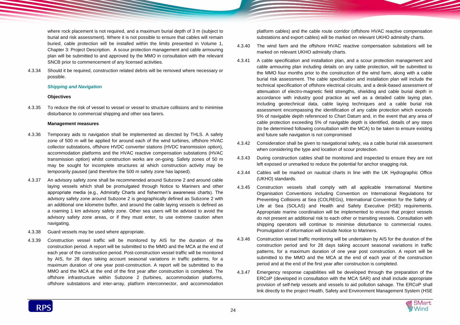
sdf
24
where rock placement is not required, and a maximum burial depth of 3 m (subject to
burial and risk assessment). Where it is not possible to ensure that cables will remain
buried, cable protection will be installed within the limits presented in Volume 1,
Chapter 3: Project Description. A scour protection management and cable armouring
plan will be submitted to and approved by the MMO in consultation with the relevant
SNCB prior to commencement of any licensed activities.
Should it be required, construction related debris will be removed where necessary or 4.3.34
possible.
Shipping and Navigation
Objectives
To reduce the risk of vessel to vessel or vessel to structure collisions and to minimise 4.3.35
disturbance to commercial shipping and other sea farers.
Management measures
Temporary aids to navigation shall be implemented as directed by THLS. A safety 4.3.36
zone of 500 m will be applied for around each of the wind turbines, offshore HVAC
collector substations, offshore HVDC converter stations (HVDC transmission option),
accommodation platforms and the HVAC reactive compensation substations (HVAC
transmission option) whilst construction works are on-going. Safety zones of 50 m
may be sought for incomplete structures at which construction activity may be
temporarily paused (and therefore the 500 m safety zone has lapsed).
An advisory safety zone shall be recommended around Subzone 2 and around cable 4.3.37
laying vessels which shall be promulgated through Notice to Mariners and other
appropriate media (e.g., Admiralty Charts and fishermen’s awareness charts). The
advisory safety zone around Subzone 2 is geographically defined as Subzone 2 with
an additional one kilometre buffer, and around the cable laying vessels is defined as
a roaming 1 km advisory safety zone. Other sea users will be advised to avoid the
advisory safety zone areas, or if they must enter, to use extreme caution when
navigating.
Guard vessels may be used where appropriate. 4.3.38
Construction vessel traffic will be monitored by AIS for the duration of the 4.3.39
construction period. A report will be submitted to the MMO and the MCA at the end of
each year of the construction period. Post-construction vessel traffic will be monitored
by AIS, for 28 days taking account seasonal variations in traffic patterns, for a
maximum duration of one year post-construction. A report will be submitted to the
MMO and the MCA at the end of the first year after construction is completed. The
offshore infrastructure within Subzone 2 (turbines, accommodation platforms,
offshore substations and inter-array, platform interconnector, and accommodation
platform cables) and the cable route corridor (offshore HVAC reactive compensation
substations and export cables) will be marked on relevant UKHO admiralty charts.
The wind farm and the offshore HVAC reactive compensation substations will be 4.3.40
marked on relevant UKHO admiralty charts.
A cable specification and installation plan, and a scour protection management and 4.3.41
cable armouring plan including details on any cable protection, will be submitted to
the MMO four months prior to the construction of the wind farm, along with a cable
burial risk assessment. The cable specification and installation plan will include the
technical specification of offshore electrical circuits, and a desk-based assessment of
attenuation of electro-magnetic field strengths, shielding and cable burial depth in
accordance with industry good practice as well as a detailed cable laying plan,
including geotechnical data, cable laying techniques and a cable burial risk
assessment encompassing the identification of any cable protection which exceeds
5% of navigable depth referenced to Chart Datum and, in the event that any area of
cable protection exceeding 5% of navigable depth is identified, details of any steps
(to be determined following consultation with the MCA) to be taken to ensure existing
and future safe navigation is not compromised
Consideration shall be given to navigational safety, via a cable burial risk assessment 4.3.42
when considering the type and location of scour protection.
During construction cables shall be monitored and inspected to ensure they are not 4.3.43
left exposed or unmarked to reduce the potential for anchor snagging risk.
Cables will be marked on nautical charts in line with the UK Hydrographic Office 4.3.44
(UKHO) standards.
Construction vessels shall comply with all applicable International Maritime 4.3.45
Organisation Conventions including Convention on International Regulations for
Preventing Collisions at Sea (COLREGs), International Convention for the Safety of
Life at Sea (SOLAS) and Health and Safety Executive (HSE) requirements.
Appropriate marine coordination will be implemented to ensure that project vessels
do not present an additional risk to each other or transiting vessels. Consultation with
shipping operators will continue to minimise disturbance to commercial routes.
Promulgation of information will include Notice to Mariners.
Construction vessel traffic monitoring will be undertaken by AIS for the duration of the 4.3.46
construction period and for 28 days taking account seasonal variations in traffic
patterns, for a maximum duration of one year post construction. A report will be
submitted to the MMO and the MCA at the end of each year of the construction
period and at the end of the first year after construction is completed.
Emergency response capabilities will be developed through the preparation of the 4.3.47
ERCoP (developed in consultation with the MCA SAR) and shall include appropriate
provision of self-help vessels and vessels to aid pollution salvage. The ERCoP shall
link directly to the project Health, Safety and Environment Management System (HSE

sdf
25
MS) to ensure that the information is part of a documented review process and
updated as required. The HSE MS will be particularly focused on ensuring safety of
navigation within proximity of the wind farm.
All construction personnel will be conversant with the project HSE MS and 4.3.48
emergency response procedures and will wear the correct Personal Protective
Equipment (PPE) at all times. This will include consideration for the use of Personnel
Locator Beacons.
Measures will be adopted to ensure that the potential for release of pollutants from 4.3.49
construction activities is minimised, which will include planning for accidental spills,
responding to all potential contaminant releases and including key emergency
contact details (e.g., Environment Agency, Natural England, JNCC, MCA, DECC and
MMO). Chemicals used during construction will be selected from the approved list
held by CEFAS under the Offshore Chemical Regulations 2002. Chemicals will be
stored in a secure, designated area in line with appropriate regulations and
guidelines. A Chemical Risk Analysis will be prepared for the use of the chemicals. A
chemical inventory shall be kept of all chemicals and oils used. Appropriate plans
shall be put in place to manage the response in the event of a spillage of chemicals
or fuel including the implementation of the MPCP and the ERCoP covering the use
and storage of all chemicals and fuels during construction
Aviation, Military and Communications
Objectives
To coordinate construction activities with military, aviation and communications 4.3.50
activities to avoid disruption.
Management measures
The Defence Infrastructure Organisation (DIO) will be kept informed of the cable 4.3.51
laying operations through Notice to Mariners, including information on the nature,
timing and location of cable laying operations.
The DIO will be informed of the date that Subzone 2 construction starts and ends; the 4.3.52
maximum height of construction equipment; and the latitude and longitude of each
wind turbine.
The UK Hydrographic Office will be informed of the locations, heights and lighting 4.3.53
status of the wind turbines including estimated and actual dates of construction and
the maximum height of any construction equipment to be used prior to construction,
to allow inclusion on Aviation Charts.
Aviation lighting shall be in accordance with the requirements of The Air Navigation 4.3.54
Order 2009 or as directed by the Civil Aviation Authority or the Secretary of State for
Defence.
An ERCoP will be implemented for the construction phase of Subzone 2. The ERCoP 4.3.55
will detail specific marking and lighting of the wind turbine generators. The MCA and
military response and coordination centres for Search And Rescue (SAR) will be
supplied with an accurate chart of the Subzone 2 wind turbine GPS positions, The
ERCoP, through consultation with the SAR helicopter units will include appropriate
emergency procedures for Project Two which meet the requirements of Marine
Guidance Note 371 (MCA, 2008a).
Throughout the construction phase there will be engagement and consultation with 4.3.56
offshore helicopter operators and oil and gas platform owners to ensure minimal
disruption to their operations.
Marine Archaeology and Cultural Heritage
Objectives
To minimise the impact of construction on marine archaeology and cultural heritage. 4.3.57
Management measures
All marine archaeological investigations and assessments will be undertaken in 4.3.58
accordance with the Marine Archaeological Written Scheme of Investigation (WSI)
which shall be written based on guidance from the Model Clauses for Archaeological
Written Schemes of Investigation: Offshore Renewables Projects (Crown Estate,
2010).
Archaeology Exclusion Zones (AEZs) will be identified and implemented around sites 4.3.59
identified as having ‘confirmed’ archaeological potential as well as those presently
identified as ‘records only’.
The Protocol for Archaeological Discoveries: Offshore Renewables Projects (Wessex 4.3.60
Archaeology, 2010) will be implemented where unexpected archaeological
discoveries are made during construction.
Archaeologists will be consulted in the preparation of any pre-construction ROV/diver 4.3.61
surveys and, if appropriate, in monitoring/checking any data. Archaeologists will also
be consulted on the preparation of pre-construction clearance operations and, if
appropriate, to carry out watching briefs of the work.
Further analysis and dating of samples will be undertaken on samples recovered 4.3.62
during pre-construction geotechnical surveys in areas where impacts on deposits of
geoarchaeological/palaoenvironmental significance seem likely.
Archaeological input will be provided on future geotechnical surveys where deposits 4.3.63
of known archaeological potential are likely to be affected. Consideration will be given
to the provision of a geoarchaeologist on the survey vessel and a provision of
sampling, analysis and reporting of recovered cores.
A watching brief will be carried out during the burial of the cable in the intertidal zone. 4.3.64

sdf
26
Final turbine locations will be sited to avoid archaeological constraints identified in 4.3.65
pre-construction surveys to avoid direct impacts to wrecks, aircraft losses and any
other archaeological remains identified on the seabed.
Results of all geoarchaeological investigations will be compiled in a final report, which 4.3.66
may include consideration of a sediment deposit model to ensure that the results of
analysis, undertaken in support of Project Two, are placed in their broader context
and made available to the scientific community and wider public.
Infrastructure and Other Users
Objectives
To avoid damage or disruption to infrastructure or other users. 4.3.67
Management measures
The crossing or laying of marine export cables from Project Two over or adjacent to 4.3.68
existing or future cables or pipelines will be subject to crossing/proximity agreements
between the developer and the cable or pipeline operators, prior to the start of the
construction phase.
This agreement will allow a cable/pipeline operator to access their pipeline/cable 4.3.69
during construction if required. The agreement will be based on the templates
(OP024) provided by Oil and Gas UK (Oil and Gas UK, 2008). If such works are to
occur simultaneously consultation with the operator shall be undertaken.
Consultation with oil and gas operators and licensees will be ongoing during the 4.3.70
construction process to promote cooperation between parties and minimise both
spatial and temporal interactions between potentially conflicting activities. This will
include promulgation of information through Notice to Mariners.
A safety zone of 500 m will be applied for around each of the wind turbines, offshore 4.3.71
HVAC collector substations, offshore HVDC converter stations (HVDC transmission
option), accommodation platforms and the HVAC reactive compensation substations
(HVAC transmission option) whilst construction works are ongoing. Safety zones of
50 m may be sought for incomplete structures at which construction activity may be
temporarily paused (and therefore the 500 m safety zone has lapsed).
During the construction phase, advisory safety zones shall be recommended around 4.3.72
Subzone 2 and around construction operations along the cable route. These areas
shall be promulgated through Notice to Mariners. The precautionary area around
Subzone 2 is geographically defined as Subzone 2 with an additional one kilometre
buffer and is a 1 km roaming advisory safety zone around construction operations
along the cable route.
Consultation with DECC and oil and gas operators will be ongoing to promote and 4.3.73
maximise cooperation between parties and minimise both spatial and temporal
interactions between conflicting activities to facilitate coexistence.

sdf
27
Bat Conservation Trust (2012). Bat Surveys – Good Practice Guidelines. Bat Conservation Trust, London.
Bat Conservation Trust (2009) Bats and Lighting in the UK, bat Conservation Trust, London.
British Standards Institute 7121 (2006) ‘Code of Practice for Safe Use of Cranes’
British Standards Institute 5228 (2009) +A1 (2014) ‘Code of Practice for Noise and Vibration Control on Construction and Open Sites’ – Part 1: Noise and Part 2: Vibration.
CIRIA (2001) C532 Control of Water Pollution from Construction Sites – Guidance for Consultants and Contractors
CIRIA (2007) C697 The SUDS Manual
Department of Communities and Local Government (2012) National Planning Policy Framework Technical Guidance
Environment Agency (2013) Pollution Prevention Guidance Note 1 (PPG1): -Understanding your environmental responsibilities – good environmental practices
Environment Agency (2014) Pollution Prevention Guidance Note 5 (PPG5): - Works in, near or over watercourses
Environment Agency et al (2014) Pollution Prevention Guidance Note 6 (PPG6): - Working at Construction and Demolition Sites
Environment Agency et al (2007) Works and maintenance in or near water
Joint Nature Conservation Committee (JNCC) (2012) Guidance for staff advising on the potential risk of seal corkscrew injuries. April 2012.
Maritime and Coastguard Agency (2008) Marine Guidance Note 371
SMart Wind (2014a) Outline Ecological Management Plan
SMart Wind (2014b) Outline Landscape Scheme and Management Plan
Wessex Archaeology (2010) Protocol for Archaeological Discoveries: Offshore Renewables Projects
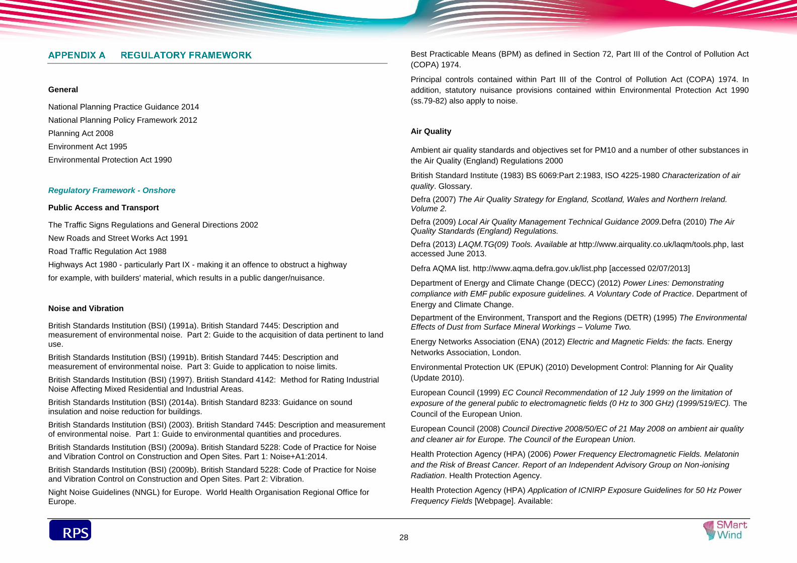
sdf
28
General
National Planning Practice Guidance 2014
National Planning Policy Framework 2012
Planning Act 2008
Environment Act 1995
Environmental Protection Act 1990
Regulatory Framework - Onshore
Public Access and Transport
The Traffic Signs Regulations and General Directions 2002
New Roads and Street Works Act 1991
Road Traffic Regulation Act 1988
Highways Act 1980 - particularly Part IX - making it an offence to obstruct a highway
for example, with builders' material, which results in a public danger/nuisance.
Noise and Vibration
British Standards Institution (BSI) (1991a). British Standard 7445: Description and measurement of environmental noise. Part 2: Guide to the acquisition of data pertinent to land use.
British Standards Institution (BSI) (1991b). British Standard 7445: Description and measurement of environmental noise. Part 3: Guide to application to noise limits.
British Standards Institution (BSI) (1997). British Standard 4142: Method for Rating Industrial Noise Affecting Mixed Residential and Industrial Areas.
British Standards Institution (BSI) (2014a). British Standard 8233: Guidance on sound insulation and noise reduction for buildings.
British Standards Institution (BSI) (2003). British Standard 7445: Description and measurement of environmental noise. Part 1: Guide to environmental quantities and procedures.
British Standards Institution (BSI) (2009a). British Standard 5228: Code of Practice for Noise and Vibration Control on Construction and Open Sites. Part 1: Noise+A1:2014.
British Standards Institution (BSI) (2009b). British Standard 5228: Code of Practice for Noise and Vibration Control on Construction and Open Sites. Part 2: Vibration.
Night Noise Guidelines (NNGL) for Europe. World Health Organisation Regional Office for Europe.
Best Practicable Means (BPM) as defined in Section 72, Part III of the Control of Pollution Act
(COPA) 1974.
Principal controls contained within Part III of the Control of Pollution Act (COPA) 1974. In
addition, statutory nuisance provisions contained within Environmental Protection Act 1990
(ss.79-82) also apply to noise.
Air Quality
Ambient air quality standards and objectives set for PM10 and a number of other substances in
the Air Quality (England) Regulations 2000
British Standard Institute (1983) BS 6069:Part 2:1983, ISO 4225-1980 Characterization of air
quality. Glossary.
Defra (2007) The Air Quality Strategy for England, Scotland, Wales and Northern Ireland. Volume 2.
Defra (2009) Local Air Quality Management Technical Guidance 2009.Defra (2010) The Air Quality Standards (England) Regulations.
Defra (2013) LAQM.TG(09) Tools. Available at http://www.airquality.co.uk/laqm/tools.php, last accessed June 2013.
Defra AQMA list. http://www.aqma.defra.gov.uk/list.php [accessed 02/07/2013]
Department of Energy and Climate Change (DECC) (2012) Power Lines: Demonstrating
compliance with EMF public exposure guidelines. A Voluntary Code of Practice. Department of
Energy and Climate Change.
Department of the Environment, Transport and the Regions (DETR) (1995) The Environmental Effects of Dust from Surface Mineral Workings – Volume Two.
Energy Networks Association (ENA) (2012) Electric and Magnetic Fields: the facts. Energy
Networks Association, London.
Environmental Protection UK (EPUK) (2010) Development Control: Planning for Air Quality
(Update 2010).
European Council (1999) EC Council Recommendation of 12 July 1999 on the limitation of
exposure of the general public to electromagnetic fields (0 Hz to 300 GHz) (1999/519/EC). The
Council of the European Union.
European Council (2008) Council Directive 2008/50/EC of 21 May 2008 on ambient air quality
and cleaner air for Europe. The Council of the European Union.
Health Protection Agency (HPA) (2006) Power Frequency Electromagnetic Fields. Melatonin
and the Risk of Breast Cancer. Report of an Independent Advisory Group on Non-ionising
Radiation. Health Protection Agency.
Health Protection Agency (HPA) Application of ICNIRP Exposure Guidelines for 50 Hz Power
Frequency Fields [Webpage]. Available:

sdf
29
http://www.hpa.org.uk/web/HPAweb&HPAwebStandard/HPAweb_C/1195733805036
[Accessed October 2012].
Health Protection Agency (HPA) Static Fields [Webpage]. Available:
http://www.hpa.org.uk/Topics/Radiation/UnderstandingRadiation/UnderstandingRadiationTopic
s/ElectromagneticFields/StaticFields. [Accessed November 2011].
Institute of Air Quality Management (IAQM) (2012a) Guidance on the Assessment of the
Impacts of Construction on Air Quality and the Determination of their Significance.
IAQM (2014) Guidance on the assessment of dust from demolition and construction.
International Agency for Research on Cancer (IARC) (2002) Non-ionising Radiation, Part 1:
Static and Extremely Low-Frequency (ELF). Monographs on the Evaluation of Carcinogenic
Risks to Humans (80).
International Commission on Non-Ionizing Radiation (ICNIRP) (1994) Guidelines on Limits of
Exposure to Static Magnetic Fields. Health Physics, vol. 66, no. 1, pp. 100-106.
International Commission on Non-Ionizing Radiation (ICNIRP) (1998) Guidelines for Limiting
Exposures to Time-Varying Electric, Magnetic and Electromagnetic Fields (Up to 300 GHz).
Health Physics, vol. 74, no. 4, pp. 494-522.
International Commission on Non-Ionizing Radiation (ICNIRP) (2009) Guidelines on Limits of
Exposure to Static Magnetic Fields. Health Physics, vol. 96, no. 4, pp. 504-512.
International Commission on Non-Ionizing Radiation (ICNIRP) (2009) Fact Sheet: On the
guidelines for limiting exposure to static magnetic fields. Health Physics, vol. 96, no. 4, pp. 504-
514.
International Commission on Non-Ionizing Radiation (ICNIRP) (2010) Guidelines for Limiting
Exposure to Time-Varying Electric and Magnetic Fields (1 Hz to 100 kHz). Health Physics, vol.
99, no. 6, pp. 818-836.
.
Vehicle Emissions – Road Vehicles (Construction and Use) Regulations 1986 as amended,
and the Motor Vehicle (Type Approval) (Great Britain) Regulations 1984.
World Health Organisation (WHO) (2006) Environmental Health Criteria 232: Static Fields.
World Health Organisation.
World Health Organisation (WHO) (2007) Environmental Health Criteria 238. Extremely Low
Frequency Fields. World Health Organisation.
Contaminated Land
Environmental Damage (Prevention and Remediation) Regulations 2009
Environment Act 1995
Environmental Protection Act 1990
Waste Management
Site Waste Management Plan Regulations 2008 (revoked December 2013)
List of Wastes (England) Regulations 2005
Hazardous Waste (England and Wales) Regulations 2005 (as amended)
Environment Act 1995
Part II of the Environmental Protection Act 1990
Protection of Surface and Groundwater Resources
Environmental Permitting (England and Wales) Regulations 2010
Water Resources Act 1991
Hazardous waste Interpretation of the definition and classification of hazardous waste. Environment Agency Technical Guidance WM2(3rd Edition 2013).
Regulatory Framework - Offshore
Marine Ecology
Agreement on the Conservation of Small Cetaceans in the Baltic and North Seas
(ASCOBANS). New York, 17 March 1992. A
Conservation of Habitats and Species Regulations 2010 (as amended) (‘Habitats
Regulations’),
Conservation of Seals Act 1970.
Convention on the Conservation of European wildlife and Natural Habitats (Berne, 1979)
(‘Berne Convention’).
Convention on the Conservation of Migratory Species of Wild Animals (Bonn, 1979) (Bonn
Convention’).
Convention on Trade in Endangered Species of Wild Flora and Fauna (CITES).
Convention on Wetlands of International Importance (1971) (‘Ramsar Convention’).
Council Directive 92/43/EEC of 21 May 1992 on the conservation of natural habitats and of wild fauna and flora (‘Habitats Directive’).
Directive 2008/56/EC on establishing a framework for community action in the field of marine
environmental policy (‘Marine Strategy Framework Directive’ (MSFD)).
Directive 2009/147/EC of the European Parliament and of the Council of 30 November 2009 on the conservation of wild birds (‘Birds Directive’).

sdf
30
Natural Environment and Rural Communities (NERC) Act 2006 (Habitats/Species of Principal Importance in England (as listed in Section 41 of the Act).
Offshore Marine Conservation (Natural Habitats, & c.) Regulations 2007 (as amended)
(‘Offshore Habitats Regulations’).
Oslo/Paris Convention (for the Protection of the Marine Environment of the North-East Atlantic)
(Paris, 1992) (‘OSPAR Convention’).
UK Biodiversity Action Plan (BAP) (1992-2012) and superceded by the UK Post-2010
Biodiversity Framework (2012-2020).
Wildlife and Countryside Act 1981.
Marine archaeology
Protection of Wrecks Act 1973
Protection of Military Remains Act 1986
Ancient Monuments and Archaeological Areas Act 1979
National Heritage Act 2002
Merchant Shipping Act 1995
Marine and Coastal Access 2009
Infrastructure
Convention on the International Regulations for Preventing Collisions at Sea 1972;
The Marine and Coastal Access Act 2009; and
Electricity (Offshore Generating Stations) (Safety Zones) (Application Procedures and Control of Access) Regulations 2007.
Airborne Noise
British Standard 5228: Code of practice for noise and vibration control on construction and open sites. Part 1: Noise (BSI, 2009);
The Merchant Shipping and Fishing Vessels (Control of Noise at Work) Regulations 2007; and
Air Quality Standard Regulations 2010.
Shipping
Energy Act 2004;
Convention on International Regulations for Preventing Collisions at Sea (COLREGS); and
The Electricity (Offshore Generating Stations) (Safety Zones) (Application Procedures and Control of Access) Regulations 2007.
Maritime and Coastguard Agency (MCA) (2008) Offshore Renewable Energy Installations (OREIs) - Guidance on UK Navigational Practice, Safety and Emergency Response Issues, MGN 371 (M+F).
Aviation
CAA, CAP 393 Air Navigation: The Order and the Regulations (CAA, August 2012).