ORISSA BENGAL WEST - Central Ground Water...
25
Ranchi Khunti Ramgarh Bokaro Gumla SIMDEGA West Singhbhum Saraikela Kharsawan Lohardaga Koderma Giridih Deoghar Jamtara Dumka Pakur Sahibganj Godda Dhanbad East Singhbhum Garhwa Latehar Palamau Chatra ORISSA WEST BENGAL BIHAR U.P. CHHATTISGARH Hazaribagh भ ू जल स ू चना प ु तिका हजारीबाग जिला, झारखंड Ground Water Information Booklet Hazaribagh District, Jharkhand State के रीय भ ू मिजल बोड जल संसाधन िंालय (भारि सरकार) राय एकक कायाडलय, राची िय-प ू ी े पटना Central Ground water Board Ministry of Water Resources (Govt. of India) State Unit Office,Ranchi Mid-Eastern Region Patna मसिंबर 2013 September 2013
Transcript of ORISSA BENGAL WEST - Central Ground Water...
Ranchi
Khunti
Ramgarh
Bokaro
Gumla
SIMDEGA
West
Singhbhum
Saraikela
Kharsawan
Lohardaga
Koderma
GiridihDeoghar
Jamtara
Dumka
Pakur
Sahibganj
Godda
Dhanbad
East
Singhbhum
Garhwa
Latehar
PalamauChatra
ORISSA
WESTBENGAL
BIHAR
U.P
.
CH
HA
TTISG
AR
H
Hazaribagh
भूजल सूचना पुस्तिका हजारीबाग जिला, झारखंड
Ground Water Information Booklet Hazaribagh District, Jharkhand State
केन्द्रीय भूमिजल बोर्ड जल संसाधन िंत्रालय (भारि सरकार) राज्य एकक कायाडलय, रााँची िध्य-पूर्वी क्षेत्र पटना
Central Ground water Board
Ministry of Water Resources
(Govt. of India) State Unit Office,Ranchi
Mid-Eastern Region Patna
मसिंबर 2013
September 2013
भूजल सूचना पुस्तिका हजारीबाग जिला, झारखंड
Ground Water Information Booklet Hazaribagh District, Jharkhand State
Prepared By
टी बी एन स हं (वैज्ञाननक )
T. B. N. Singh
(Scientist C)
राज्य एकक कायाडलय, रााँची िध्य-पूर्वी क्षेत्र,पटना
State Unit Office, Ranchi
Mid Eastern Region, Patna
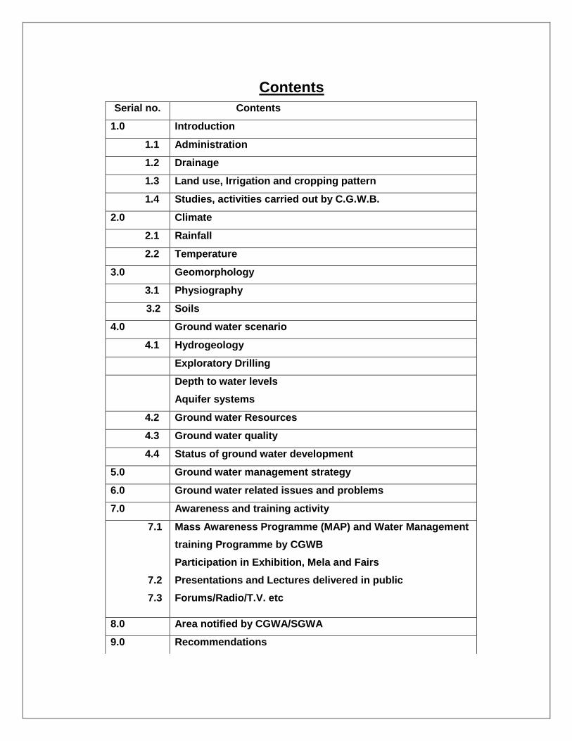
Contents
Serial no. Contents
1.0 Introduction
1.1 Administration
1.2 Drainage
1.3 Land use, Irrigation and cropping pattern
1.4 Studies, activities carried out by C.G.W.B.
2.0 Climate
2.1 Rainfall
2.2 Temperature
3.0 Geomorphology
3.1 Physiography
3.2 Soils
4.0 Ground water scenario
4.1 Hydrogeology
Exploratory Drilling
Depth to water levels
Aquifer systems
4.2 Ground water Resources
4.3 Ground water quality
4.4 Status of ground water development
5.0 Ground water management strategy
6.0 Ground water related issues and problems
7.0 Awareness and training activity
7.1
7.2
7.3
Mass Awareness Programme (MAP) and Water Management
training Programme by CGWB
Participation in Exhibition, Mela and Fairs
Presentations and Lectures delivered in public
Forums/Radio/T.V. etc
8.0 Area notified by CGWA/SGWA
9.0 Recommendations
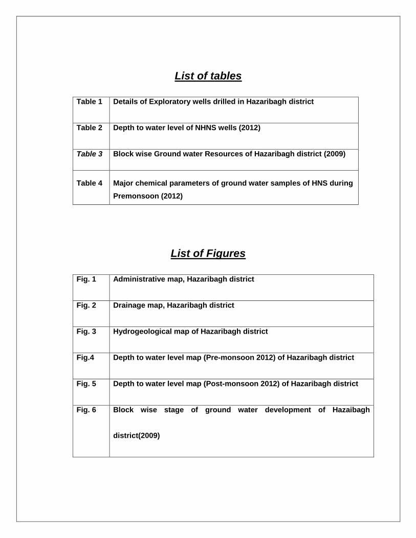
List of tables
Table 1 Details of Exploratory wells drilled in Hazaribagh district
Table 2 Depth to water level of NHNS wells (2012)
Table 3 Block wise Ground water Resources of Hazaribagh district (2009)
Table 4 Major chemical parameters of ground water samples of HNS during
Premonsoon (2012)
List of Figures
Fig. 1 Administrative map, Hazaribagh district
Fig. 2 Drainage map, Hazaribagh district
Fig. 3 Hydrogeological map of Hazaribagh district
Fig.4 Depth to water level map (Pre-monsoon 2012) of Hazaribagh district
Fig. 5 Depth to water level map (Post-monsoon 2012) of Hazaribagh district
Fig. 6 Block wise stage of ground water development of Hazaibagh
district(2009)
HAZARIBAGH DISTRICT AT A GLANCE
Sl No.
ITEMS Statistics
1. GENERAL INFORMATION
Geographical Area (Sq km.) (As on 2011)
4302 Sq. km.
(i) Administrative Divisions (As on 2011) Number of Blocks Number of Panchyats Number of Villages
16 330 1659
(ii) Population (As on 2011 Census) 17,34,005
(iii) Average Annual Rainfall (mm) 1234 mm
2. GEOMORPHOLOGY
Major Physiographic units Pediplains, dissected plateau, Erosional valley, ridges and valley
Major Drainages Barakar, Konar, Bokaro and Damodar
3. LAND USE (Sq Km.)
a) Forest area: 2566
b) Net area sown: 1061
c) Cultivable area: 1183
4. MAJOR SOIL TYPES Alfisols (Red sandy soils) Ultisols (red and yellow soils) Light textured Slightly Acidic, Poor in N & P, Fairly rich in K
5. AREA UNDER PRINCIPAL CROPS (ha) Pulses – 2263 Oilseeds – 1353 Paddy – 26291
6. IRRIGATION BY DIFFERENT SOURCES Area (Ha) Structures
Dugwell 14132 39363
Tube wells /Bore wells 46 6
Tanks / Ponds 391 83
Canals --- ----
Other Sources 3924 758
Net irrigated area ---- ---
Gross irrigated area ---- -----
7. NUMBERS OF GROUND WATER MONITORING WELLS OF CGWB (As on 31-03-13) No of Dugwell No. of Piezometers
15 Nil
8. PREDOMINANT GEOLOGICAL FORMATIONS
Granite Gneissic Complex, Gondwanas
9. Hydrogeology
Major Water bearing formation Pre-monsoon Depth to water level
during 2012 Post-monsoon Depth to water level
during 2012
Granites, Granite gneiss, Gondwanas 6.90-11.90 mbgl 2.10-8.90 mbgl
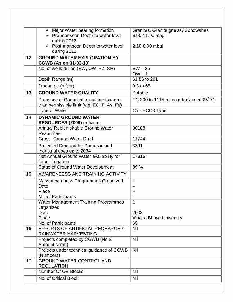
12. GROUND WATER EXPLORATION BY CGWB (As on 31-03-13)
No. of wells drilled (EW, OW, PZ, SH) EW – 26 OW – 1
Depth Range (m) 61.86 to 201
Discharge (m3/hr) 0.3 to 65
13. GROUND WATER QUALITY Potable
Presence of Chemical constituents more than permissible limit (e.g. EC, F, As, Fe)
EC 300 to 1115 micro mhos/cm at 250 C.
Type of Water Ca - HCO3 Type
14. DYNAMIC GROUND WATER RESOURCES (2009) in ha-m
Annual Replenishable Ground Water Resources
30188
Gross Ground Water Draft 11744
Projected Demand for Domestic and Industrial uses up to 2034
3391
Net Annual Ground Water availability for future irrigation
17316
Stage of Ground Water Development 39 %
15. AWARENESSS AND TRAINING ACTIVITY
Mass Awareness Programmes Organized Date Place No. of Participants
-- -- -- --
Water Management Training Programmes Organized Date Place No. of Participants
1 2003 Vinoba Bhave University 65
16. EFFORTS OF ARTIFICIAL RECHARGE & RAINWATER HARVESTING
Nil
Projects completed by CGWB (No & Amount spent)
Nil
Projects under technical guidance of CGWB (Numbers)
Nil
17 GROUND WATER CONTROL AND REGULATION
Number Of OE Blocks Nil
No. of Critical Block Nil
No. of Blocks notified Nil
18. MAJOR GROUND WATER PROBLEMS AND ISSUES
Low discharge of bore wells in Gondwana Formations
GROUND WATER INFORMATION BOOKLET HAZARIBAGH DISTRICT
1.0 Introduction
1.1 Administration— The district of Hazaribagh is situated in the north east of north
Chotanagpur divison. The boundary of the district consists of districts of Gaya
and koderma in the north, Giridih and bokaro in the east, Ranchi in the South and
Palamau and chatra in the west. The Hazaribagh district consists of total area of
4302 Sq. Km. The district comprises of 16 no. of blocks namely Hazaribagh,
Chauparan, Barhi, Padma, Ichak, Barkatha, Bishungarh, KatkamSandi,
Keredari,Barkagaon,Patratu, Churchu, Mandu, Ramgarh and Gola. The district
has total population of 17, 34,005(2011 census). There was change of 25.75
percent in the population compared to population as per 2001. In the previous
census of India 2001, Hazaribagh District recorded increase of 26.13 percent to
its population compared to 1991
The NH-33 connects Ranchi to Patna and it passes through the
Hazaribagh. The National Highway No. 2 (G.T.Road) passes through the
chauparan, Barhi and Barkatha block.Density of population is 403 persons per
sq. km.
1.2 Drainage---
The district is drained by two major rivers, the Damodar and the Barakar
river with a few minor tributaries like Naikari, Bhera, Kusum, Bokaro, Mohana
and kumari. The Naikari with drainage from the south and further down the Bhera
joins the Damodar river. The Damodar has I, II, III and IV order tributaries
whereas the river Barakar has only II and III order tributaries namely Keso, Harhi,
Barsot, Chandwara, Kolhuteri, Karkara and Kewta.In the southern portion of the
district, river Konar has a second order tributary viz. the Siwane river which is
flowing south to south-east. All these tributaries show dendritic to sub-dendritic
drainage pattern typical of granitic terrain. The Damodar and the Barakar rivers
show structurally controlled pattern. The drainage here is highly dissected in
criss-cross fashion.
0K.M. 5 10 K.M.5
SCALE
Chauparan
Barhi
Padma
Katkamsandi
Ichak
Barkatha
Chalkusha
Hazaribagh
Katkamdag
BarkagaonKeredari
Churchu
Dari
Daru
TatijhariaBishnugarh
85° 15' 85° 45'
23°
45'
85° 30'
85° 15' 85° 45'85° 30'24°
00'
24°
15'
23°
45'
24°
00'
24°
15'
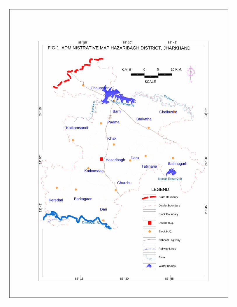
FIG-1 ADMINISTRATIVE MAP HAZARIBAGH DISTRICT, JHARKHAND
District H.Q.
Block H.Q.
District Boundary
Block Boundary
State Boundary
River
LEGEND
Railway Lines
National Highway
NH
-33
Konar Reservoir
Barakar R.
Bara
kar
R. Tilaiya Reservoir
Damodar R.
Water Bodies
0K.M. 5 10 K.M.5
SCALE
85° 15' 85° 45'
23°
45'
85° 30'
85° 15' 85° 45'85° 30'
24°
00'
24°
15'
23°
45'
24°
00'
24°
15'
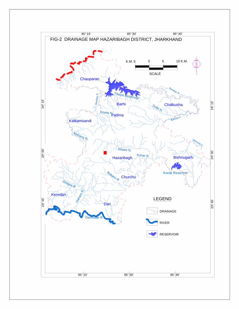
FIG-2 DRAINAGE MAP HAZARIBAGH DISTRICT, JHARKHAND
DRAINAGE
RIVER
RESERVOIR
Chauparan
Barhi
Padma
Katkamsandi
Chalkusha
Hazaribagh
Keredari
Churchu
Dari
Bishnugarh
Ghagra R
Bokaro R
Haharo
R.
Konar R
Konar Reservoir
Barakar R.
Damodar R.
Siwani N.
Barsoti n.
Jamunia n.
Bara
kar
R.
Mohana R.
Kewta N.
Dulki N.
Tilaiya Reservoir
LEGEND
1.3—Land use, Irrigation and cropping pattern –
As per 2012 land use pattern, district has 4302 sq. km. area. Forest area
is 2560 sq. km (42.3%). Land put to non-agricultural use is 376 sq. km. (6.21%).
Barren and uncultivable land is 541 sq.km. (8.9%). Current fallow is 730 sq. km.
and land other than current fallow is 560 sq. km. (9.2%). Net area sown is 1061
sq. km. (17.5%). Kharif and Rabi are the two seasons for agriculture. Kharif
extends from the end of June to the end of October when Paddy, maize, cereals
and millets are grown. Rabi starts at the end of October and continues up to the
end of March.wheat, Barley, maize grams and vegetables are grown during this
season. The district has very little irrigation facilities. Irrigation is done mostly
from dug wells, tanks and talabs. The culturable land is divided into two
categories, namely, the upland and the lowland. Uplands are suitable for dry
crops whereas paddy is grown in low land.
1.4---Studies/ activities carried out by C.G.W.B.—
Systematic hydrogeological investigation in the Damodar basin of
Hazaribagh district was done by D.P.Ghose of G.S.I. in the year 1969-70.A
report on District hydrogeology and Ground water Resources of the Hazaribagh
district was done by B.B.Bhattacharya (Scientist-B) in the year 1989-
90.Altogether 26 no. of exploratory drilling was done in the Hazaribagh district up
to March 2013.About 48 no. of vertical electrical sounding (V.E.S.) was done by
B.K.Oraon (Scientist-B) around Hazaribagh urban area to know about low
resistivity zones in the area
2.0 Climate—
The area experiences three distinct seasons namely summer (March-
May), Monsoon (June-October) and winter (November –February)
2.1 Rainfall—
Annual average rainfall is 1347 mm.
2.2 Temperature—
During peak summer maximum temp. goes up to 460C and minimum
temperature drops down to 40C.
3.0 Geomorphology
3.1 Physiography—
Physiographically, the district consists of Plateaus, residual hills and
inermontane valleys. The district can be divided into three divisions namely the
Central Plateau, The lower plateau and the Damodar valley. The Central plateau
is situated in the central part of the district. Hazaribagh town lies in this part
having an average elevation of 600m.The lower plateau is situated all around
surrounding the central plateau. The height of the lower plateau averages to
450m.The Damodar valley region is situated in the southern part and extends
through the blocks of Keredari, Barkagaon, Patratu, Ramgarh and Gola blocks.
The average elevation varies from 150-200m.
3.2 Soils-
Three types of soils are found in the district.
(a) Hill and forest soils of steep slopes and high-dissected region in
Barkagaon, Bishungarh and Charhi blocks.
(b) Red yellow and light grey soil in Barhi, Ichak, Katkamsandi, keredari
and Hazaribagh blocks.
(c) Pale yellow, yellow and pinkish deep soil on high micaceous schists.
4.0 Groundwater Scenario
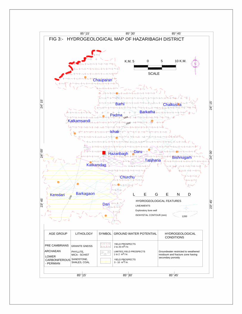
4.1 Hydrogeology -
Geologically the area is underlain by Chotanagpur granite gneiss, phyllite-
mica-schist. It is unconformably overlain by lower Gondwana formations
consisting of Sandstone, Shales and Coal seams. Ground water mainly occurs
under water table condition in weathered residuum and semi-confined condition
in deeper fractures. Granite rocks show maximum thickness of weathered mantle
in favourable topographic and drainage condition.
0K.M. 5 10 K.M.5
SCALE
85° 15' 85° 45'
23°
45'
85° 30'
85° 15' 85° 45'85° 30'
24°
00'
24°
15'
23°
45'
24°
00'
24°
15'
FIG 3:- HYDROGEOLOGICAL MAP OF HAZARIBAGH DISTRICT
Chauparan
Barhi
Padma
Katkamsandi
Ichak
Barkatha
Chalkusha
Hazaribagh
Katkamdag
BarkagaonKeredari
Churchu
Dari
Daru
TatijhariaBishnugarh
1500
1300
1100
L E G E N D
HYDROGEOLOGICAL FEATURES
ARCHAEAN LIMITED YIELD PROSPECTS
1 to 2 m / hr.
AGE GROUP LITHOLOGY HYDROGEOLOGICAL
CONDITIONS
GROUND WATER POTENTIAL
LOWER
CARBONIFEROUS
- PERMIAN
SANDSTONE,
SHALES, COALYIELD PROSPECTS
3 - 10 m / hr.
LINEAMENTS
ISOHYETAL CONTOUR (mm)1200
PRE CAMBRIANS
PHYLLITE,
MICA - SCHIST
GRANITE GNEISSYIELD PROSPECTS
2 to 20 m / hr.
Groundwater restricted to weathered
residuum and fracture zone having
secondary porosity
3
3
3
SYMBOL
Exploratory bore well
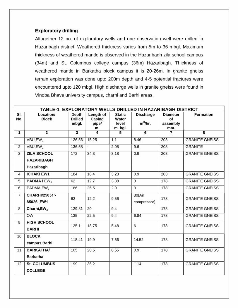
Exploratory drilling-
Altogether 12 no. of exploratory wells and one observation well were drilled in
Hazaribagh district. Weathered thickness varies from 5m to 36 mbgl. Maximum
thickness of weathered mantle is observed in the Hazaribagh zila school campus
(34m) and St. Columbus college campus (36m) Hazaribagh. Thickness of
weathered mantle in Barkatha block campus it is 20-26m. In granite gneiss
terrain exploration was done upto 200m depth and 4-5 potential fractures were
encountered upto 120 mbgl. High discharge wells in granite gneiss were found in
Vinoba Bhave university campus, charhi and Barhi areas.
TABLE-1 EXPLORATORY WELLS DRILLED IN HAZARIBAGH DISTRICT Sl. No.
Location/ Block
Depth Drilled mbgl.
Length of Casing pipe/
m.
Static Water level
m. bgl.
Discharge
m3/hr.
Diameter of
assembly mm.
Formation
1 2 3 4 5 6 7 8
VBU,EW1 136.56 15.25 1.1 8.46 203 GRANITE GNEISS
2 VBU,EW2 136.58 - 2.08 9.6 203 GRANITE
3 ZILA SCHOOL 172 34.3 3.18 0.9 203 GRANITE GNEISS
HAZARIBAGH
Hazaribagh
4 ICHAK/ EW1 184 18.4 3.23 0.9 203 GRANITE GNEISS
5 PADMA / EW1 62 12.7 3.38 3 178 GRANITE GNEISS
6 PADMA,EW2 166 25.5 2.9 3 178 GRANITE GNEISS
7 CHARHI/25051’-
85026’,EW1 62 12.2 9.56
30(Air
compressor) 178 GRANITE GNEISS
8 Charhi,EW2 129.81 20 9.4
178 GRANITE GNEISS
OW 135 22.5 9.4 6.84 178 GRANITE GNEISS
9 HIGH SCHOOL
BARHI 125.1 18.75 5.48 6 178 GRANITE GNEISS
10 BLOCK
campus,Barhi 118.41 19.9 7.56 14.52 178 GRANITE GNEISS
11 BARKATHA/ 105 20.5 8.55 0.9 178 GRANITE GNEISS
Barkatha
12 St. COLUMBUS 199 36.2
1.14 178 GRANITE GNEISS
COLLEGE
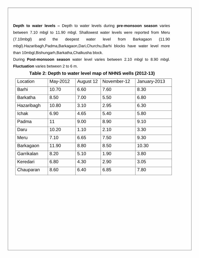
Depth to water levels – Depth to water levels during pre-monsoon season varies
between 7.10 mbgl to 11.90 mbgl. Shallowest water levels were reported from Meru
(7.10mbgl) and the deepest water level from Barkagaon (11.90
mbgl).Hazaribagh,Padma,Barkagaon,Dari,Churchu,Barhi blocks have water level more
than 10mbgl,Bishungarh,Barkatha,Chalkusha block.
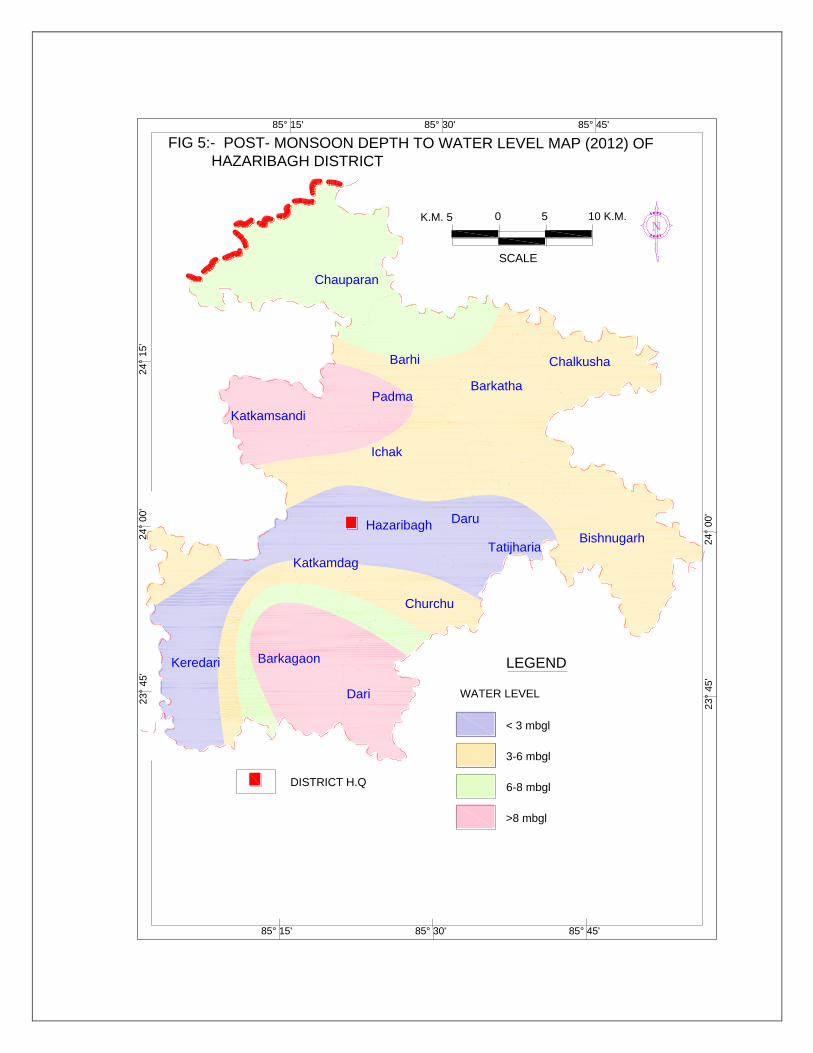
During Post-monsoon season water level varies between 2.10 mbgl to 8.90 mbgl.
Fluctuation varies between 2 to 6 m.
Table 2: Depth to water level map of NHNS wells (2012-13)
Location May-2012 August 12 November-12 January-2013
Barhi 10.70 6.60 7.60 8.30
Barkatha 8.50 7.00 5.50 6.80
Hazaribagh 10.80 3.10 2.95 6.30
Ichak 6.90 4.65 5.40 5.80
Padma 11 9.00 8.90 9.10
Daru 10.20 1.10 2.10 3.30
Meru 7.10 6.65 7.50 9.30
Barkagaon 11.90 8.80 8.50 10.30
Garrikalan 8.20 5.10 1.90 3.80
Keredari 6.80 4.30 2.90 3.05
Chauparan 8.60 6.40 6.85 7.80
0K.M. 5 10 K.M.5
SCALE
FIG 4 :- PRE-MONSOON DEPTH TO WATER LEVEL MAP (2012) OFHAZARIBAGH DISTRICT
WATER LEVEL
DISTRICT H.Q
85° 15' 85° 45'
23°
45'
85° 30'
85° 15' 85° 45'85° 30'
24°
00'
24°
15'
23°
45'
24°
00'
24°
15'
LEGEND
Chauparan
Barhi
Padma
Katkamsandi
Ichak
Barkatha
Chalkusha
Hazaribagh
Katkamdag
BarkagaonKeredari
Churchu
Dari
Daru
TatijhariaBishnugarh
0K.M. 5 10 K.M.5
SCALE
85° 15' 85° 45'
23°
45'
85° 30'
85° 15' 85° 45'85° 30'
24°
00'
24°
15'
23°
45'
24°
00'
FIG 5:- POST- MONSOON DEPTH TO WATER LEVEL MAP (2012) OFHAZARIBAGH DISTRICT
6-8 mbgl
>8 mbgl
3-6 mbgl
WATER LEVEL
< 3 mbgl
DISTRICT H.Q
LEGEND
Chauparan
Barhi
Padma
Katkamsandi
Ichak
Barkatha
Chalkusha
Hazaribagh
Katkamdag
BarkagaonKeredari
Churchu
Dari
Daru
TatijhariaBishnugarh
Aquifer systems –
Two types of aquifers are observed in both Granite- gneiss and
Gondwana rocks. Phreatic aquifer is observed in weathered formations and
Semi-confined to confined aquifers in deeper fractures. Water levels in phreatic
aquifers vary between 3-10mbgl. Piezometric head in Granite- gneiss varies
between 2-9 mbgl.
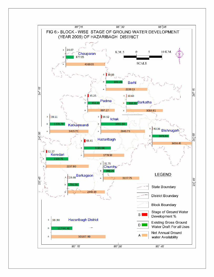
4.2 Ground water Resources—
The Ground water assessment has been done based on the
recommendation of the GEC-1997.The Ground water assessment has been
carried out on the block wise basis for the year 2009. Padma block (997 ha-m)
has lowest resource while Chauparan block (4369 ha-m) has the highest
resources. Net annual ground water availability is 30188 ha-m..Existing ground
water draft for all uses comes out to be 11744 ha-m. Net ground water availability
for future irrigation is 17316 ha-m. Stage of Ground water development is 39%.
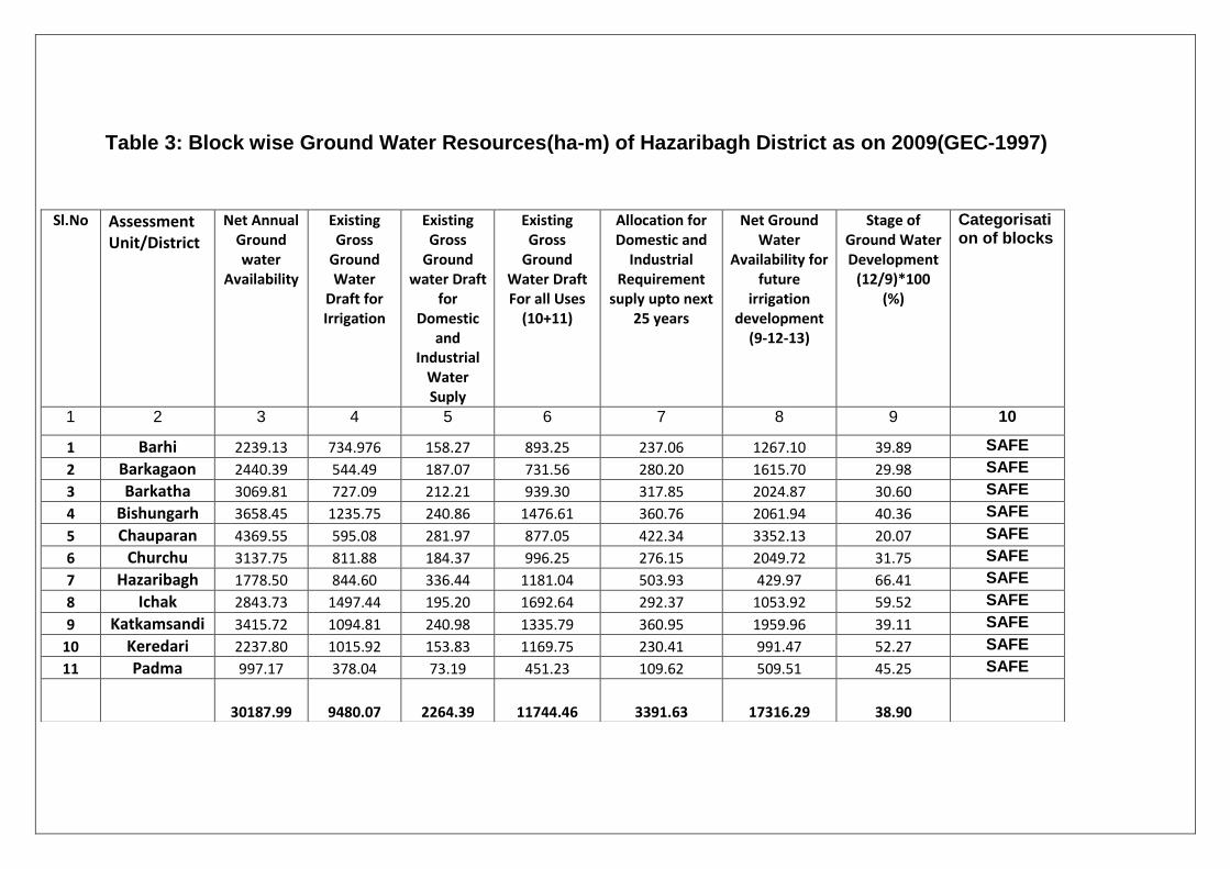
Table 3: Block wise Ground Water Resources(ha-m) of Hazaribagh District as on 2009(GEC-1997)
Sl.No Assessment Unit/District
Net Annual Ground water
Availability
Existing Gross
Ground Water
Draft for Irrigation
Existing Gross
Ground water Draft
for Domestic
and Industrial
Water Suply
Existing Gross
Ground Water Draft For all Uses
(10+11)
Allocation for Domestic and
Industrial Requirement
suply upto next 25 years
Net Ground Water
Availability for future
irrigation development
(9-12-13)
Stage of Ground Water Development
(12/9)*100 (%)
Categorisation of blocks
1 2 3 4 5 6 7 8 9 10
1 Barhi 2239.13 734.976 158.27 893.25 237.06 1267.10 39.89 SAFE
2 Barkagaon 2440.39 544.49 187.07 731.56 280.20 1615.70 29.98 SAFE
3 Barkatha 3069.81 727.09 212.21 939.30 317.85 2024.87 30.60 SAFE
4 Bishungarh 3658.45 1235.75 240.86 1476.61 360.76 2061.94 40.36 SAFE
5 Chauparan 4369.55 595.08 281.97 877.05 422.34 3352.13 20.07 SAFE
6 Churchu 3137.75 811.88 184.37 996.25 276.15 2049.72 31.75 SAFE
7 Hazaribagh 1778.50 844.60 336.44 1181.04 503.93 429.97 66.41 SAFE
8 Ichak 2843.73 1497.44 195.20 1692.64 292.37 1053.92 59.52 SAFE
9 Katkamsandi 3415.72 1094.81 240.98 1335.79 360.95 1959.96 39.11 SAFE
10 Keredari 2237.80 1015.92 153.83 1169.75 230.41 991.47 52.27 SAFE
11 Padma 997.17 378.04 73.19 451.23 109.62 509.51 45.25 SAFE
30187.99 9480.07 2264.39 11744.46 3391.63 17316.29 38.90
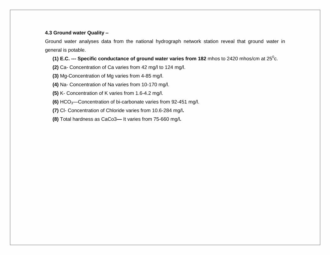
4.3 Ground water Quality –
Ground water analyses data from the national hydrograph network station reveal that ground water in
general is potable.
(1) E.C. --- Specific conductance of ground water varies from 182 mhos to 2420 mhos/cm at 250c.
(2) Ca- Concentration of Ca varies from 42 mg/l to 124 mg/l.
(3) Mg-Concentration of Mg varies from 4-85 mg/l.
(4) Na- Concentration of Na varies from 10-170 mg/l.
(5) K- Concentration of K varies from 1.6-4.2 mg/l.
(6) HCO3—Concentration of bi-carbonate varies from 92-451 mg/l.
(7) Cl- Concentration of Chloride varies from 10.6-284 mg/l.
(8) Total hardness as CaCo3— It varies from 75-660 mg/l.
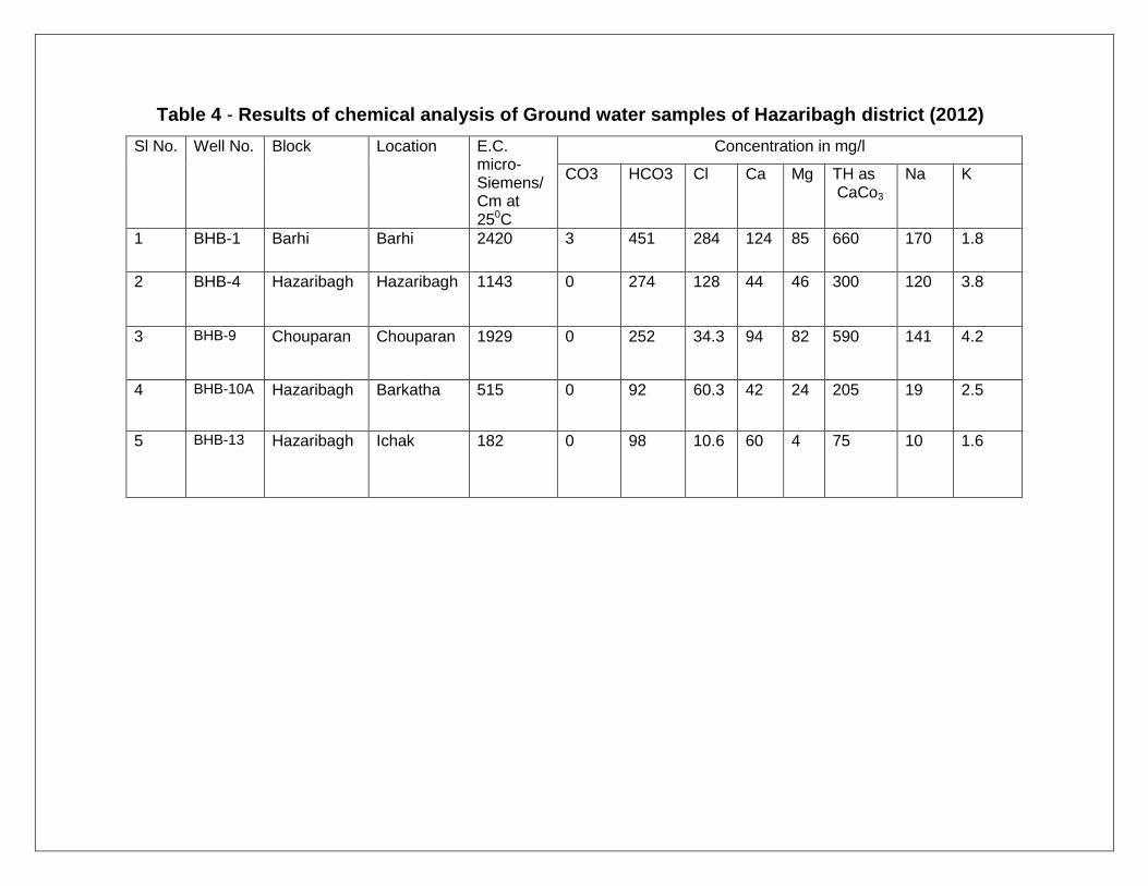
Table 4 - Results of chemical analysis of Ground water samples of Hazaribagh district (2012)
Sl No. Well No. Block Location E.C. micro-Siemens/Cm at 250C
Concentration in mg/l
CO3 HCO3 Cl Ca Mg TH as CaCo3
Na K
1 BHB-1 Barhi Barhi 2420 3 451 284 124 85 660 170 1.8
2 BHB-4 Hazaribagh Hazaribagh 1143 0 274 128 44 46 300 120 3.8
3 BHB-9 Chouparan Chouparan 1929 0 252 34.3 94 82 590 141 4.2
4 BHB-10A Hazaribagh Barkatha 515 0 92 60.3 42 24 205 19 2.5
5 BHB-13 Hazaribagh Ichak 182 0 98 10.6 60 4 75 10 1.6
4.4 Status of ground water development—
Overall stage of ground water development is 39%. Hazaribagh
block has the highest stage of ground water development (66.41%) and
Chauparan block (20.07%) has the lowest stage of ground water
development. At present ground water is feeding entire requirement of
water for domestic purpose except a few places like Hazaribagh where
lake reservoirs are used. Recently a few dams namely Lotoa and Salparni
have been constructed for irrigation purposes.
5.0 Ground water management strategy—
In Hazaribagh district ground water is localized in the secondary
porosity i.e. fractures in granite gneiss and gondwana rocks. C.G.W.B.
have drilled 26 no. of borewells in the district .Exploratory wells at
Ramgarh cant, vinoba bhave university camus Hazaribagh, Barhi block
campus and Charhi are high productive wells. Lineaments are
concentrated mostly in Ichak, Barkatha, barkagaon and keredari blocks.
Valley fills area and areas having more lineament density are most
promising sites for potential ground water. Resistivity survey should be
preceded before exploratory drilling.
Water conservation and artificial recharge—
Long-term NHNS trend of Hazaribagh, Barhi and Padma blocks show
declining trend so these areas are suitable for artificial recharge. Check
dams, Gully plugging, contour bunding, Nala bunding, cement plugging
are some of the Rain water harvesting structures that can be implemented
in rural areas of Hazaribagh district. Roof top rainwater harvesting can be
a suitable option in Hazaribagh urban areas.
6.0 Ground water related issues
7.0 Awareness and training activity---
7.1 One training programme on Artificial recharge to Ground water was
organized at Vinoba Bhave University campus in Hazaribagh.Vice-
chancellor of the university Dr. Bahura Ekka was the chief guest. The
Scientists of C.G.W.B delivered lectures on ground water conservation
and techniques of artificial recharge.
8.0 Areas notified by C.G.W.A./S.G.W.A. –
All blocks of the district comes under safe category.
9.0 Recommendations—
1. Remote sensing studies coupled with Hydrogeological investigation
and followed by Resistivity survey is essential to locate favourable sites for
ground water drilling in the district.
2. In pediment and shallow buried pediment, large diameter open
wells are suggested for optimum extraction. Rectangular shape (that is
longer axis perpendicular to the major fracture) is desirable in place of
rounded well.
3. Hazaribagh, Ichak and Padma blocks are suitable for Artificial
recharge and Rainwater harvesting.
4. Large number of bore wells drilled in granite gneiss show good
discharge during weathered formation drilling but due to casing of the
weathered formation, the discharge is diminished. So, Slotted casings can
be a good option where both weathered and fractured cumulative
discharge can be utilized.