OREGON INVENTORY OF HISTORIC PROPERTIES SECTION 106 ...
17
Surveyor/Agency: Kramer & Company/George Kramer Date Recorded: July 2007 106 Documentation Pg 1 OREGON INVENTORY OF HISTORIC PROPERTIES SECTION 106 DOCUMENTATION FORM Agency/Project: Ideal Cement Company Dam & Powerhouse (City of Gold Hill/Dam Removal Project) Street Address: Rogue River Channel at R.M. 120-121 City, County: v. Gold Hill, Jackson County USGS Quad Name: Gold Hill 7.5 minute Quadrangle Township: 36S Range: 3W Section: 15 Tax Lot #: 600 District, Grouping or Ensemble? Name: n/a Current Use: Diversion Dam, Vacant/Not in Use Date of Construction: c1920s, 1944 Architectural Classification/Resource Type: Industry: Waterworks_ Dam, Industry: Energy Facility_Powerhouse Alterations & Dates: Serially modified Window Type & Material: See Narrative Roof Type & Material: See Narrative Exterior Surface Materials: Primary: Concrete, Poured in Place Secondary: Metal Decorative: N/A Condition: Excellent Good Fair Poor Integrity: Excellent Good Fair Poor Ideal Cement Company Diversion Dam, Looking East, from headgate, Jun 2007 Preliminary National Register Findings: National Register listed Potentially Eligible: Individually As part of District Not Eligible: In current state Irretrievable integrity loss Lacks Distinction Not 50 Years State Historic Preservation Office Comments: Concur Do Not Concur: Potentially Eligible Individually Potentially Eligible As part of District Not Eligible Signed _____________________________________________________ Date ______________________________ Comments:
Transcript of OREGON INVENTORY OF HISTORIC PROPERTIES SECTION 106 ...

Surveyor/Agency: Kramer & Company/George Kramer Date Recorded: July 2007 106 Documentation Pg 1
OREGON INVENTORY OF HISTORIC PROPERTIESSECTION 106 DOCUMENTATION FORM
Agency/Project: Ideal Cement Company Dam & Powerhouse (City of Gold Hill/Dam Removal Project)
Street Address: Rogue River Channel at R.M. 120-121 City, County: v. Gold Hill, Jackson County
USGS Quad Name: Gold Hill 7.5 minute Quadrangle
Township: 36S Range: 3W Section: 15 Tax Lot #: 600
District, Grouping or Ensemble?
Name: n/a
Current Use: Diversion Dam, Vacant/Not in Use Date of Construction: c1920s, 1944
Architectural Classification/Resource Type:Industry: Waterworks_ Dam, Industry: EnergyFacility_Powerhouse
Alterations & Dates: Serially modified
Window Type & Material: See Narrative
Roof Type & Material: See Narrative
Exterior Surface Materials:
Primary: Concrete, Poured in Place
Secondary: Metal
Decorative: N/A
Condition:
Excellent Good Fair Poor
Integrity:
Excellent Good Fair Poor
Ideal Cement Company Diversion Dam, Looking East, from headgate, Jun 2007
Preliminary National Register Findings:
National Register listed Potentially Eligible: Individually As part of District
Not Eligible: In current state Irretrievable integrity loss Lacks Distinction Not 50 Years
State Historic Preservation Office Comments:
Concur Do Not Concur:
Potentially Eligible Individually Potentially Eligible As part of District Not Eligible
Signed _____________________________________________________ Date ______________________________
Comments:

Surveyor/Agency: Kramer & Company/George Kramer Date Recorded: July 2007 106 Documentation Pg 2
OREGON INVENTORY OF HISTORIC PROPERTIESSECTION 106 DOCUMENTATION FORM
Street Address: Rogue River channel at R.M. 120-121 City, County: v. Gold Hill, Jackson County
Architect, Builder or Designer (if known):
Unknown
Property Category:
Building Structure District Site Object
Owner:
Private Local Government. State Federal Other
Name: City of Gold Hill, OR (Attn Royal Gasso, Public Works Director)
Address: 165 4th Street
City, State, Zip: Gold Hill, Oregon 97525
Phone: 541.855.1525
Description of Property (including exterior alterations & approximate dates), Significance Statement, and Sources.(Use continuation sheets if necessary):
The Ideal Cement Company Dam and Powerhouse complex is a multiple element grouping of resourceslocated along the Rogue River channel northeast of Gold Hill, Oregon. The complex includes aconcrete diversion dam, diverting water into a canal that leads to a powerhouse built by the IdealCement Company to supply its plant in Gold Hill. After the company ceased operation, the diversiondam remained functional a part of the City’s municipal watersupply. With completion of a new waterintake approximately 150-feet upstream, the Diversion Dam is no longer integral to the system and theCity of Gold Hill proposes to remove the entire dam structure upstream of the headgate to eliminatefish obstructions in the Rogue River channel. This proposal is based on the recommendations of a PhaseII report prepared for the City of Gold Hill by the Bureau of Reclamation under the direction of theRogue River Basin Fish Passage Technical Committee (BofR, 2001).
The Ideal Cement Company Dam and Powerhouse are the last in a series of waterworks andhydroelectric facilities that have served Gold Hill from this location since the late 19th century and, assuch, have some general association with the industrial and economic development of the region. Thecurrent facilities, however, lack sufficient distinction or association due to their late construction andcomparatively short period of operation. The Ideal Cement Company Dam and Powerhouse complex isconsidered Not Eligible for listing on the National Register of Historic Places.
Description:
The Ideal Cement Company Dam and Powerhouse complex includes both in-stream built resources aswell as related structures located upon Jackson County Assessor’s Parcel 36-3W-15-600, a 52.43 acreparcel lining the western bank of the river downstream from the division dam. The property includesLots 1, 2, 3, 4 and 9 of the Water Park Addition to the City of Gold Hill. Individual elements of thecomplex, starting upstream, are;
1. Diversion Dam (1944): The 1000 foot long “l-shaped” gravity-type concrete diversion damconsists of two main portions.
A. Left Dam Crest, a roughly 400-foot long section that extends from the right bank (east)across the main channel and averages 2 feet in height above the channel bottom.
B. Right Dam Crest, a roughly 600-foot long concrete section that is generally parallel to theriver channel and directs flows into the diversion canal headgates. The Right Dam Crest

OREGON INVENTORY OF HISTORIC PROPERTIESSECTION 106 DOCUMENTATION FORM
Continuation Sheet
Street Address: Rogue River channel at R.M. 120-121 City, County: v. Gold Hill, Jackson County
Surveyor/Agency: Kramer & Company/George Kramer Date Recorded: July 2007 106 Documentation Pg 3
averages 6 feet in height and is punctuated by regularly spaced buttress elements that arevisible on the downstream face. An additional “Upstream Extension,” believed to be a remnant of an earlier diversion structure, continues upstream from the Right Dam Crest for155 feet although it is typically below water level during normal flows (Bureau ofReclamation, 2001:16).
2. Headgate (1944): This 50-foot wide concrete structure controls the increased flow behind theRight Dam Crest as it enters the canal. Divided into three sections by buttresses, the headgateincludes three 14-foot wide, 4-foot high steel radial gates, each manually controlled by turn-screws accessed via the walkway across the crest. Historic photos indicate a small tramway overthe headgate and continuing to the surviving concrete wing-wall that extends toward thechannel. The top is now accessed via a non-original galvanized steel walkway with galvanizedrailing.
3. Canal (1920s, as modified): Of varied width but generally 50-feet wide, the canal downstreamof the headgates flows for approximately 1700-feet to the fish barrier, screens, and powerhouseforebay/penstocks. Unlined, this feature is believed to be an enlarged version of an earlier canalthat lead to the first pump and powerhouse built sometime in the late-1910s or early 1920s.The canal may be an elaboration of even earlier millraces related to water-powered industry inthe vicinity that pre-date 1900.
4. Fish Screens (1944): Approximately 200-feet upstream from the powerhouse, the fish screensystem in the canal is a concrete and steel structure that consists of a full-width fish barrier anda series of “V-Shaped” concrete and steelfish baffles that are in-line with the water flow. Builtin 1944, this element was apparently abandoned and replaced by the fish ladder (which entersthe canal at the channel side just downstream of the fish barrier) before the discontinuation ofpower generation at the site in 1968.
5. Fish Ladder (c1955): A concrete stepped system, the fish ladder lines the east (river channel)side of the diversion canal and then takes a series of steps down to the entry point at theupstream side of the powerhouse. Exact construction of the element is believed to post-datethe initial construction period, supplanting the ealier Fish Screen/V-Baffle system.
6. Penstocks/Gates (1944): Six radial gates built of steel are pocketed in a cast-concrete extensionof the powerhouse foundation and control flow to the turbines. Similar in design to theheadgates, these features are approximately 10-feet wide and 12-feet tall, each originallycontrolled by a electric motor (rather than the manual control of the headgates).
7. Powerhouse (1944): Rising from a massive poured-in-place concrete foundation approximately26-feet wide and 72-feet long, the superstructure of the powerhouse is of stucco over diagonalsheathing and wood framing. Heavy wood columns support the steel beams of a gantry cranethat runs the full building length. Exterior character is utilitarian, with simple stepped detailing

OREGON INVENTORY OF HISTORIC PROPERTIESSECTION 106 DOCUMENTATION FORM
Continuation Sheet
Street Address: Rogue River channel at R.M. 120-121 City, County: v. Gold Hill, Jackson County
Surveyor/Agency: Kramer & Company/George Kramer Date Recorded: July 2007 106 Documentation Pg 4
at the cornice, 16/16 wood window sash set in paired groups and three hipped-roof ventilatorsaccenting the otherwise plain stucco design. Cross-braced wood sliding doors provide access tothe interior.
No longer operational and in very poor condition, all three generation units along with thecontrol console, governors and other equipment remain in place.
8. Tailrace/Return Flow (1944): Water exiting the turbines returns to the main channel of theRogue River though exit tubes at the foundation base into the Tailrace. Excess water from theforebay (upstream of the penstocks) flows toward the “wasteway” or Return Flow channelthrough a 10-foot vertical narrow tunnel of bedrock that is located immediately downstreamfrom the small steel bridge/walkway access to the powerhouse.
History & Significance:
The first water diversion in this area of the Rogue River Channel apparently dates from the late 19th
century and the construction of the Houck Mill, a water-powered flour mill that opened in 1892(MMT, 7-Nov-1999). The mill was powered via the Houck Ditch, remnants of which survived as lateas 1925 when it appears on maps of the area the “Old Houck Ditch.” The City of Gold Hill, whichinitially drew water directly from the river for domestic use, apparently built the first diversion canal forits water supply sometime prior to WWI and then later expanded that canal and constructed first a log,and then a concrete, diversion dam to feed a pump house located in the general vicinity of the currentIdeal Cement Company Powerhouse.1 While the specific construction of this first powerhouse and theimprovements to the original log diversion dam have not been documented, they were likely related tothe development of the Beaver Portland Cement Company Plant in 1911.
Initial construction of the Portland-based company’s $700,000 cement manufacturing facilities began in1911 on a large tract north of downtown Gold Hill, from designs by the Hunt Engineering Company ofKansas City, Kansas (MMT, 2-November-1916, 6:1-8). Difficulty in securing equipment stoppedconstruction in 1914 but it resumed in 1916 and the plant produced it first product in November ofthat year. Under various owners, the cement plant would remain a mainstay in the Gold Hill, andsouthern Oregon, economy for the next half-century.
The capacity of the plant is 1000 barrels, or 4000 sacks, of cement a day. Thematerials used are 250 tons of limestone, 100 tons of shale, 10 tons of gypsumand 10,000 gallons of crude oil (MMT, 2-November-1916, 6:1-8).
The Beaver Portland Cement Company employed more than 100 workers, a considerable segment ofthe Gold Hill population. Raw materials were taken from company-owned quarries in JosephineCounty and transferred to the plant via a company-owned railroad for processing. Cement manufacturerequired considerable amounts of energy to fire the revolving kiln that burned the crushed slurry ofmaterials at 200 degrees Fahrenheit. Early accounts of the Beaver project note it would utilize powerfrom the Rogue River Electric Company, operators of the Gold Ray Powerhouse, at Tolo, about twomiles upstream from Gold Hill (Scott, 1914). By 1925 the company was described as “the largest users
1 It is unclear if this building also provided for small scale hydroelectric generation although the 1925 map of thearea clearly identifies the building as a “Powerhouse.”

OREGON INVENTORY OF HISTORIC PROPERTIESSECTION 106 DOCUMENTATION FORM
Continuation Sheet
Street Address: Rogue River channel at R.M. 120-121 City, County: v. Gold Hill, Jackson County
Surveyor/Agency: Kramer & Company/George Kramer Date Recorded: July 2007 106 Documentation Pg 5
of electric power in southern Oregon” (MMT, 4-December-1925, 6:1). Most of this power was stillpurchased from the local private utility, the California Oregon Power Company (COPCO), a successorto Rogue River Electric, although some was apparently generated by the cement company itself, throughits lease of a city-owned plant that stood at the head of the improved “Power Canal” in the vicinity of the Old Houck Ditch (See Map No. 3).
In late 1925 the Beaver Portland Cement Company announced its plan to invest $400K to improve andupgrade its Gold Hill operation, roughly doubling production capacity. As a part of this effort, BeaverPortland Cement, in connection with the City of Gold Hill, intended to build a new and largerpowerhouse near the existing plant on the Rogue River. This proposal required additional waterdiversion to allow for the greater generation capacity. COPCO, which still supplied the majority ofelectric power to the cement plant, also owned property in the immediate vicinity of the Gold HillPowerhouse that was required for the proposed improvements. COPCO sued the City and BeaverCement to stop the expansion project. The crux of this suit stemmed from water right and the cementcompany’s plans to enlarge the diversion dam and canal. This litigation would take a circuitous routethrough almost every level of the US legal system for the next decade. Initially, COPCO wassuccessful, with a US District Court ruling in 1928 that forced the City and the cement company toremove falsework for construction of the diversion dam (Oregonian, 23-December-1928, 5:2). In1935, however, the United States Supreme Court ruled in favor of the cement company, clearing theway for construction of the expanded powerhouse.2
Meanwhile, in 1933, during the extensive, lengthy, and presumably costly, litigation, the BeaverPortland Cement Company (by then reorganized as the Pacific Portland Cement Company) sold itsentire operation in Gold Hill, including the proposed construction of the dam and powerhouse, to theIdeal Cement Company, of Denver, Colorado (JCD 228:102-105). Ideal Cement, controlled by theBoettcher family, had been formed in 1924 from several earlier Boettcher enterprises and soon grewinto one of the largest cement manufacturers in United States with multiple plants throughout thewest.3
Likely delayed by the economic climate during the Great Depression, and then World War II,construction on the Ideal Cement Company Dam and Powerhouse at Gold Hill did not begin until late1944. Work was apparently completed in about a year, with the plant going into operation sometime inlate-1945 or very early 1946. The three horizontal-type generation units of the Ideal Cement CompanyPowerhouse developed a total of 25Kw. In addition to supplying power for the cement company,excess power was sold to the citizens of Gold Hill, who also benefited from heavily subsidized waterrates for domestic uses (Apperson, 1960; Kell, 1986:50; Martin, 1999).
The Ideal Cement Company Dam and Powerhouse continued to operate as initially intended for 25years, an integral element of a major Gold Hill industry that employed a significant portion of the
2 In his majority opinion for California Oregon Power Co. v. Beaver Portland Cement Co (295 US 1942). Mr.Justice Sutherland interpreted elements of the Desert Land Act of 1877 that reinforce government right,establishing interpretation of the law is still frequently cited in water law cases.3 By 1955 Ideal Cement was considered the third largest cement manufacturer in North America, with 13 plantssupplying 26 western states. Reorganized as Ideal Basic Industries in 1976, the company was sold to Holderbankof Switzerland. (Peterson, 2007, Koepp, 1987).

OREGON INVENTORY OF HISTORIC PROPERTIESSECTION 106 DOCUMENTATION FORM
Continuation Sheet
Street Address: Rogue River channel at R.M. 120-121 City, County: v. Gold Hill, Jackson County
Surveyor/Agency: Kramer & Company/George Kramer Date Recorded: July 2007 106 Documentation Pg 6
town’s population. “It is a round-the-clock operation…we employ 100 men, work in three shifts and never close” (O’Harra, 1964). In 1965, however, Ideal announced plans that its aging Gold Hill plant“…rapidly approaching obsolescence, would be retired upon completion of a new plant at Seattle…” (MMT, Jan 2, 1967) Production in Gold Hill ceased on April 30, 1969 ending more than half-centuryof operations at the site. Ideal converted the project for use as a storage facility.
Several years later Ideal ceased all operations in Gold Hill and a contractual provision resulted in thedam and powerhouse elements reverting to the City of Gold Hill, a provision that the City initiallyfought and which Ideal sued to enforce (Stanley, 1983). Several public-private partnership effortsinvolving the City attempted to return the powerhouse to generation although none were successful(Stanley, 1980, Flint, 1983). Eventually the water rights associated with the project expired for lack ofuse and the City’s legal proceedings to have them re-established failed (Gasso, 2007).
Today, virtually all elements of the former Ideal Cement Company production site north of downtownGold Hill have been removed and the site has been partially re-developed for residential uses along ORHwy 234 (Sams Valley Highway) with the remaining portions largely vacant land.4 Power generationhas never resumed at the Ideal Cement Powerhouse and Dam Complex since the 1969 plant closure.The City of Gold Hill, which built a new water filtration plant near the powerhouse site in 1981,continued to rely upon the dam as an element of its domestic water supply until the construction of thenew water intake system in 2006.5
The Diversion Dam, no longer required as part of the Gold Hill water system, is to be removed by 2008to improve fish passage on this stretch of the Rogue River. Below the headgate, which will remain, thecanal will be dewatered however the fish screens, powerhouse, and other elements of the complex willremain in place.
Conclusion:
The last of a series of waterworks and powerhouse developments at this location in Gold Hill, Oregon,the Ideal Cement Company Dam and Powerhouse complex was largely constructed built between1944-45 to provide electrical for cement manufacture, with excess energy and water used by thecitizens of Gold Hill. Although built following substantial litigation that culminated at the UnitedStates Supreme Court, the Ideal Cement Dam and Powerhouse lack any distinctive design elements orassociative significance and are considered NOT ELIGIBLE for listing on the National Register ofHistoric Places.
4 Site review in June 2007 identified a single standing structure located within a fenced area. Parcels fronting onOregon Highway 99 have been split into small lots and developed for residential uses. A large ‘cut’ in the hillside above is the single most visible element remaining from the former cement operation.5 At various times in the 1980s the City attempted to either sell the powerhouse to PacifiCorp, successor toCOPCO, or to enter into joint-partnership agreements with other entities so that power generation could resume.None of these proposals were successful (Stanley, 1980, Flint 1983).

OREGON INVENTORY OF HISTORIC PROPERTIESSECTION 106 DOCUMENTATION FORM
Continuation Sheet
Street Address: Rogue River channel at R.M. 120-121 City, County: v. Gold Hill, Jackson County
Surveyor/Agency: Kramer & Company/George Kramer Date Recorded: July 2007 106 Documentation Pg 7
Selected Bibliography
Apperson, Jim. “Commercial Analysis of Gold Hill, Oregon.” Unpublished paper prepared for Dr. A. S.Taylor, Southern Oregon College Department of History, 1960.
BofR (Bureau of Reclamation). City of Gold Hill Fish Passage Improvements at the Municipal WaterSupply Diversion: Phase II. Prepared by the Bureau of Reclamation under the Direction of theRogue River Basin Fish Passage Technical Committee, September 2001.
Flint, Mark. “Gold Hill Faces Opposition to Hydro Project on Rogue,” Medford Mail Tribune, June 9,1983.
JCD (Jackson County Deed), as cited by Volume: Page.Kell, Clarence A. Oral History Interview #89. Southern Oregon Historical Society, Medford, OR.,
April 3, 1989.Koepp, Stephen. “America for Sale,” Time Magazine, September 14, 1987.Martin, Melissa. “River Conduit Cemented in City’s History,” Medford Mail Tribune, November 7,
1999.MMT (Medford Mail Tribune), Misc. Issues as cited by date.O’Harra, Marjorie. “Cement Plant Never Closes,” Medford Mail Tribune, May 17, 1964.Oregonian. Misc. Issues as cited in text.Rosecrans, Charles E. The Gold Hill Cement Plant. Gold Hill, OR: Gold Hill Historical Society,
January 1997.Scott, W. A. “Beaver Portland Cement Company’s New Plant,” Pacific Builder and Engineer,
September 5, 1914.Stanley, Denise. “New Investors Optimistic About Gold Hill Plant,” Medford Mail Tribune, April 20,
1980.Peterson, Betsy. Personal Communication with the Author, June 2007 (Ms. Woods is an
Administrative Assistant at the Boettcher Foundation, a major Denver-era philanthropic entity).

OREGON INVENTORY OF HISTORIC PROPERTIESSECTION 106: SUPPLEMENTAL PHOTOGRAPHS
Street Address: Rogue River channel at R.M. 120-121 City, County: v. Gold Hill, Jackson County
Surveyor/Agency: Kramer & Company/George Kramer Date Recorded: July 2007 106 Documentation Pg 8
MAP 1: Vicinity, Ideal Cement Company Dam & Powerhouse Complex(River Design Group, 2006)

OREGON INVENTORY OF HISTORIC PROPERTIESSECTION 106: SUPPLEMENTAL PHOTOGRAPHS
Street Address: Rogue River channel at R.M. 120-121 City, County: v. Gold Hill, Jackson County
Surveyor/Agency: Kramer & Company/George Kramer Date Recorded: July 2007 106 Documentation Pg 9
MAP 2: Vicinity, Ideal Cement Company Dam & Powerhouse Complex(USGS Gold Hill 7.5m Topo Map, annotated)

OREGON INVENTORY OF HISTORIC PROPERTIESSECTION 106: SUPPLEMENTAL PHOTOGRAPHS
Street Address: Rogue River channel at R.M. 120-121 City, County: v. Gold Hill, Jackson County
Surveyor/Agency: Kramer & Company/George Kramer Date Recorded: July 2007 106 Documentation Pg 10
MAP 3: Historic Map (1925) Gold Hill, Oregon,shaded to show powerhouse, power canal. Note “Old Houck Ditch.”
(Nicholas Brothers Map, Jackson County Surveyors Office File # 54/4)

OREGON INVENTORY OF HISTORIC PROPERTIESSECTION 106: SUPPLEMENTAL PHOTOGRAPHS
Street Address: Rogue River channel at R.M. 120-121 City, County: v. Gold Hill, Jackson County
Surveyor/Agency: Kramer & Company/George Kramer Date Recorded: July 2007 106 Documentation Pg 11
MAP 4: Site Map, Ideal Cement Dam & Powerhouse Complex(River Design Group, 2007)

OREGON INVENTORY OF HISTORIC PROPERTIESSECTION 106: SUPPLEMENTAL PHOTOGRAPHS
Street Address: Rogue River channel at R.M. 120-121 City, County: v. Gold Hill, Jackson County
Surveyor/Agency: Kramer & Company/George Kramer Date Recorded: July 2007 106 Documentation Pg 12
MAP 5: 36-3W-15, Tax Lot 600(Jackson County Assessors Plat, Annotated)
OREGON INVENTORY OF HISTORIC PROPERTIESSECTION 106: SUPPLEMENTAL PHOTOGRAPHS
Street Address: Rogue River channel at R.M. 120-121 City, County: v. Gold Hill, Jackson County
Surveyor/Agency: Kramer & Company/George Kramer Date Recorded: July 2007 106 Documentation Pg 13
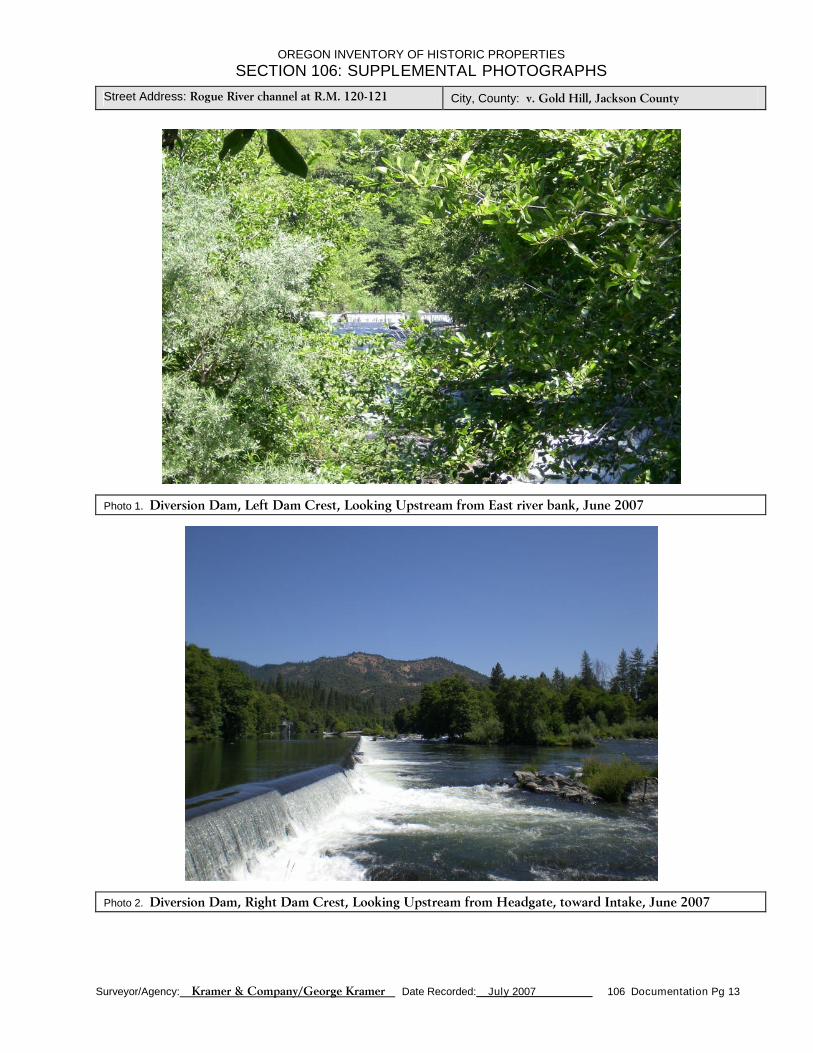
Photo 1. Diversion Dam, Left Dam Crest, Looking Upstream from East river bank, June 2007
Photo 2. Diversion Dam, Right Dam Crest, Looking Upstream from Headgate, toward Intake, June 2007

OREGON INVENTORY OF HISTORIC PROPERTIESSECTION 106: SUPPLEMENTAL PHOTOGRAPHS
Street Address: Rogue River channel at R.M. 120-121 City, County: v. Gold Hill, Jackson County
Surveyor/Agency: Kramer & Company/George Kramer Date Recorded: July 2007 106 Documentation Pg 14
Photo 3. Headgate, Looking Upstream from East canal bank, June 2007
Photo 4. Power Canal, Looking Downstream from Headgates, July 2005 (Royal Gasso Photo)

OREGON INVENTORY OF HISTORIC PROPERTIESSECTION 106: SUPPLEMENTAL PHOTOGRAPHS
Street Address: Rogue River channel at R.M. 120-121 City, County: v. Gold Hill, Jackson County
Surveyor/Agency: Kramer & Company/George Kramer Date Recorded: July 2007 106 Documentation Pg 15
Photo 5. Fish Screens, Looking Downstream toward Powerhouse, July 2007
Photo 6. Fish Ladder (Exit, at tailrace), Looking Upstream, July 2007

OREGON INVENTORY OF HISTORIC PROPERTIESSECTION 106: SUPPLEMENTAL PHOTOGRAPHS
Street Address: Rogue River channel at R.M. 120-121 City, County: v. Gold Hill, Jackson County
Surveyor/Agency: Kramer & Company/George Kramer Date Recorded: July 2007 106 Documentation Pg 16
Photo 7. Powerhouse, Looking NE, July 2007
Photo 8. Powerhouse, Looking NW, from tailrace area, July 2007

OREGON INVENTORY OF HISTORIC PROPERTIESSECTION 106: SUPPLEMENTAL PHOTOGRAPHS
Street Address: Rogue River channel at R.M. 120-121 City, County: v. Gold Hill, Jackson County
Surveyor/Agency: Kramer & Company/George Kramer Date Recorded: July 2007 106 Documentation Pg 17
Photo 9. Powerhouse, INTERIOR View, Looking North, July 2007
Photo 10. Return (Wasteway) Channel, Looking Downstream, June 2007