Orange County Auditor-Controller – Orange County Auditor ...

Orange County Fire Authority
After Action ReportSantiago FireOctober 21 - November 9, 2007
A Report to theOrange County Fire Authority
Board of Directors
Table of Contents For w rd ........................................................................................................ Page 1 Executive Summary ...................................................................................... Page 3 Historical Information .................................................................................. Page 7 Fire Prevention and Community Education ............................................ Page 15 Incident Overview
Advance Planning .....................................................................................Page 23 Incident Narrative .....................................................................................Page 39 Mutual Aid and Regional Resource Coordination ...................................Page 69 Air Resources ...........................................................................................Page 75 Logistics Support .....................................................................................Page 81 Incident Communications ........................................................................Page 85 Emergency Operations Centers ................................................................Page 89 Media and Public Communications ..........................................................Page 97 Arson Investigation.................................................................................Page 101 Volunteer Groups and Resources............................................................Page 103
Fiscal Impacts ............................................................................................. Page 109 Recovery Efforts ........................................................................................ Page 111 Major Challenges ...................................................................................... Page 119 Lessons Learned ........................................................................................ Page 121 Recommendations ..................................................................................... Page 123 Glossary of Terms ...................................................................................... Page 129
oe
Santiago Fire – October 2007
Page 1
Foreword I’m extremely proud of the heroic efforts of fire and law enforcement personnel who worked so hard during the Santiago Fire to protect our residents, and their homes and property. Many firefighters, deputies and police officers from multiple jurisdictions worked continuously for over 60 hours without rest during the initial stage of the fire to protect lives, while evacuating thousands of residents, saving homes and combating the fire’s rapid progress. In addition, our professional staff provided an incredible level of incident support to those on the front lines. I’m also very pleased with how well our current fire prevention measures contributed to our ability to safely evacuate residents and defend large numbers of threatened structures in the wildland urban interface areas. OCFA’s progressive and proactive fire prevention programs proved without doubt, that the ability for firefighters to save property during an event such as the Santiago Fire is directly influenced by fire resistive construction features and requirements for defensible space around homes. The high level of cooperation and assistance provided by a wide array of public agencies, volunteer groups and members of our communities, contributed greatly to the Orange County Fire Authority’s ability to meet the challenges presented during this wind driven fire storm. Our unified command, in conjunction with support from the various county and city EOCs, was able to manage a number of complex issues during the fire, while keeping residents and business owners informed of the fire’s progress and threat to individual communities. We’re certainly fortunate that there was no loss of life, and that property damage wasn’t more severe during the fire. This can be attributed to the outstanding efforts of our fire suppression forces, law enforcement personnel and the many other agencies and groups that provided support during the fire. However, I’m unwilling to use the term successful outcome when residents lose their homes, despite the extreme conditions or contributing factors. My personal commitment is that the OCFA will continue to research additional fire prevention measures that will help to make our communities less vulnerable to these types of fires, seek opportunities to enhance our local capability and surge capacity to respond to fires of this magnitude, and provide additional training to better prepare OCFA’s personnel for future incidents such as the Santiago Fire. Respectfully,
Chip Prather, Fire Chief

Santiago Fire – October 2007
Page 2
PAGE INTENTIONALLY LEFT BLANK

Santiago Fire – October 2007
Page 3
Executive Summary The October 2007 Fire Siege in Southern California began on October 20, 2007. It was fueled by an extreme Santa Ana wind condition and low humidity. According to statistics compiled by the Governor’s Office of Emergency Services, the fire siege resulted in 22 major fires and numerous smaller fires over a three week period ending November 9, 2007. This fire siege impacted 7 Southern California counties, including Orange, San Diego, Los Angeles, San Bernardino, Ventura, Santa Barbara, and Kern. Over 517,000 acres were burned, with a total of 2,233 homes, 5 businesses, and 966 out buildings destroyed. Fires in San Diego County alone, destroyed over 1,740 homes, with another 450 destroyed in San Bernardino County, 28 in Los Angeles County, and 14 homes in Orange County. There were 10 confirmed fire related fatalities and 139 injuries to civilians attributed to this disastrous fire siege. The fires resulted in the largest evacuation in California history, with more than 321,500 evacuees. Local, state, and federal disaster declarations were proclaimed for all of these areas. The Santiago Fire was one of the major fires during this period, and the most disastrous wildland fire in Orange County in over 30 years. This arson caused fire began during the early evening of October 21, 2007 near Santiago Canyon Road and Silverado Canyon Road, east of Irvine Lake. Driven by extreme Santa Ana winds of 50 mph (hurricane force gusts to 85 mph), combined with low humidity and long range spotting of embers, the fire spread 3 miles in less than 20 minutes. Within 2 hours the fire was 5,000 acres, and reached 15,000 acres in the first 16 hours. The Santiago Fire burned for 19 days, until it was declared contained at 6:00 a.m. on November 8, 2007. Control actions continued throughout the day, and the fire was declared fully under control at 6:00 a.m. on November 9th. Crews continued to periodically patrol the fire area for 14 more days to ensure that all control lines remained cold and completely extinguished, as aggressive restoration and recovery efforts began to protect burned areas from flood dangers related to winter rains. The fire ultimately burned 28,517 acres with a total of 42 structures destroyed (14 homes, 4 commercial buildings, and 24 out buildings). Another 14 structures (8 homes, 3 commercial buildings, and 3 out buildings) were damaged. Additional damage included building contents, over 44 vehicles, avocado groves, and landscaping equipment. Many residents and businesses suffered smoke damaged property, lost wages, and other economic impacts that are impossible to calculate. Estimated damage was $27.5 million. Suppression costs were approximately $6.6 million. Following guidelines for Federal Public Assistance, on October 31, 2007, a Local Government Fiscal Responsibility Agreement was made between CAL FIRE, FEMA/OES, and OCFA concerning reimbursement of resources for the Santiago Fire. Based on the Local Government Fiscal Responsibility Agreement, OCFA expects reimbursement of at least 95% of costs associated with the Santiago Fire. There are additional minimal costs for which OCFA
Santiago Fire – October 2007
Page 4
will not be reimbursed. These non-reimbursable costs are still being reviewed and tabulated. Fortunately, there were no deaths or serious injuries to civilians or firefighters, but there were 16 minor type injuries to OCFA firefighters. At the height of the fire, thousands of residents and businesses were forced to evacuate. In the rural communities of Silverado Canyon, Modjeska Canyon, Williams Canyon, Hamilton Road, Live Oak Canyon, and Trabuco Canyon over 1,900 homes and businesses were given mandatory evacuation orders. Many other residents, businesses, and schools in Portola Hills and Foothill Ranch in the City of Lake Forest were advised to voluntarily evacuate. Residents in the impacted areas of Northwood and Portola Springs in the City of Irvine, and the Tustin Ranch area in the City of Tustin were sheltered-in-place or asked to voluntarily evacuate. A Unified Command and strong coordination between fire and law enforcement was the key element of success in evacuating large numbers of residents and animals in the path of this rapidly burning fire. Heroic efforts by firefighters and existing fire prevention measures requiring defensible space, non-combustible roofs, fuel modification zones, and ignition resistant construction were the major factors in saving hundreds of homes. Steep canyons, old brush, combustible construction, restricted access, minimal defensible space, and a lack of firefighting resources, were major contributing factors with homes that were destroyed or damaged. At the peak of the fire, there were almost 2,000 fire personnel from 170 different agencies and 330 deputies and police officers from 5 local law enforcement agencies, including the Orange County Sheriff’s Department, Irvine Police Department, Tustin Police Department, Orange Police Department, and the California Highway Patrol assigned to the incident. More than 250 local, state, federal, private, and non-profit entities cooperated or provided assistance during this disastrous fire, along with over 300 volunteers from various programs throughout the County. The incident was managed under a Unified Command structure consisting of the Orange County Fire Authority, Orange County Sheriff’s Department, CAL FIRE, and the U.S. Forest Service. There were a number of complex challenges and contributing factors during the Santiago Fire. These included prolonged extreme weather conditions that resulted in very rapid fire spread, long range spotting due to flying embers, large scale evacuations, and the protection of structures in residential communities adjacent to wildland interface areas. One of the most difficult challenges was the lack of available resources (air and ground) to attack the perimeter spread of the fire. The California Fire Service Master Mutual Aid System was overwhelmed due to multiple major fires burning across Southern California, and OCFA was forced to rely solely upon ground resources (engines) available from within the County for the first 48+ hours of the fire, except for a single out-of-area Strike Team that arrived Monday night, October 22nd, but was not assigned to fireline duties until Tuesday morning, due to crew fatigue. The OCFA and neighboring departments within Orange County mustered 90+ engines (equivalent to 18

Santiago Fire – October 2007
Page 5
Strike Teams) to battle the Santiago Fire during this critical period. The majority of these ground resources were committed to directly protecting lives and property, while the main body of the fire spread uncontrolled along the perimeter. By 6:00 p.m. on Tuesday, October 24th, the fire had consumed over 19,000 acres (65% of the total acreage ultimately burned) and the majority of structures destroyed and damaged had already occurred, except for two additional homes that were destroyed in Williams Canyon very early Wednesday morning. During this same time period, only one Strike Team (5 engines) had been received from outside of Orange County, and the only air resources operating on the fire during the first 36+ hours were OCFA’s two helicopters. On the first full day of the fire (Monday), Incident Commanders were advised that fixed wing air tankers were unable to fly due to high winds, and additional helicopters were unavailable. Much debate ensued regarding the availability of air resources, and there are several inquiries (state and federal) underway to examine this specific issue. There is little doubt if additional wildland firefighting resources (ground and air) would have been more readily available earlier in the fire, the outcome likely would have been different. However, considering the fact that there were 9 significant fires burning in Southern California, with evacuations in progress and homes being lost on at least 5 of them at the time the Santiago Fire started, fire resources were simply overwhelmed and stretched beyond capacity. A number of the conclusions in this After Action Report point to things that went well such as OCFA’s advance planning and additional staffing for the extreme weather conditions which resulted in the staffing of 40 additional engines and contributed to “surge capacity” during the initial stages of the fire. Additionally, OCFA’s ongoing fire prevention efforts contributed directly to saving thousands of homes, by providing firefighters with defensible space to protect threatened structures. Other conclusions illustrate areas that can be improved or should be reviewed for follow-up action with the appropriate agency or policy group. Over 1,300 arson leads have been received by OCFA’s Investigation Services Section and all are being thoroughly followed-up. The fire investigation remains a very high priority, and is currently considered to be an open criminal investigation. The recommendations contained in the report are intended to help OCFA better prepare for this type of disastrous wildland fire in the future and improve local capability and surge capacity where possible. Some of these recommendations will require further study, review, and cost analysis to determine the feasibility of implementation. Others are no cost items to implement, or require follow-up action with the appropriate outside agency or group.

Santiago Fire – October 2007
Page 6
PAGE INTENTIONALLY LEFT BLANK

Santiago Fire – October 2007
Page 7
Historical Information Beginning October 20, 2007, Southern California was besieged by an extreme Santa Ana wind event, and a series of disastrous wildland fires, which became known as the October 2007 Fire Siege. During the first four days of this extreme wind event, firefighting agencies throughout Southern California successfully suppressed 251 vegetation fires (approximately 90% of all fires) without any loss of life or property, during the initial attack phase while the fires were small. However, there were 22 major fires, impacting 7 Southern California counties during this time period. Over 517,000 acres were burned, with a total of 2233 homes lost. Fires in San Diego County alone, destroyed 1740 homes, with another 450 lost in San Bernardino County, 28 in Los Angeles County and 14 homes in Orange County. There were 10 civilian deaths and 139 injuries attributed to this disastrous fire siege. At the height of these blazes, over 321,500 residents were evacuated, and local, state and federal disaster declarations were proclaimed for all of these counties. The Santiago Fire in Orange County was one of these devastating major fires. The fire ultimately burned 28,517 acres with a total of 42 structures destroyed (14 homes, 4 commercial buildings and 24 out buildings). Another 14 structures (8 homes, 3 commercial buildings and 3 out buildings) were damaged. Additional damage included building contents, over 44 vehicles, avocado groves and landscaping equipment. Many residents and businesses suffered smoke damaged property, lost wages and other economic impacts that are impossible to calculate. Estimated damage was $27.5 million. Fortunately, there were no fatalities or serious injuries to firefighters or civilians. However, there were 139 reported civilian injuries, and 58 reported injuries to firefighting personnel (44 OCFA members) of a less than serious nature. Orange County’s wildfire history has repeated itself for thousands of years. Factors influencing the severity of the county’s wildland fires include its topography, fuels, weather and wildland-urban interface (WUI) encroachment. Narrow canyons, mountainside slopes, and ridgelines with curving saddles, are all typical to wildland regions of Orange County and sustain and intensify fires. Common Orange County vegetation, such as chaparral thickets and coastal sage scrub, create vast heaps of highly flammable leaves and dry woods during its normal life cycle. Many of these native plants have waxy leaves that form flammable tinder as they dry out. Typically, 40-60% of plants that are over 20 years old are dead, highly volatile fuels. Many areas of Orange County, including areas burned during the Santiago Fire, have fuels ranging from 50 to 100 years old. Less preheating is required as fire moves through these older, dead fuels, dramatically increasing the rate and intensity of fire spread.
However, weather is the most critical factor in fire behavior, as well as the most unpredictable. Long periods of low rainfall and drought conditions increase the

Santiago Fire – October 2007
Page 8
amount of dead vegetation. Freezes such as the one that affected some areas of Orange County in mid-January, 2007, convert live, moist fuel into dead dry fuel. Low humidity saps the moisture from plants, reducing both live and dead fuels to tinder. Wind remains the single most influential weather factor. High pressure systems over Utah and Nevada push dry air toward California. As the air passes over the Mohave Desert, it gains heat; then funneled and compressed through the mountain passes, the heated winds accelerate. The results are Santa Ana winds, which exacerbate low humidity and result in conditions where virtually any spark can ignite a fire.
Over the past 30 years Orange County has experienced a number of major wildland fire disasters. The Table below (30 Year Major Fire History – Orange County) lists selected Orange County wildland fires that covered large geographic areas (greater than 2000 acres), burned out-of-control for an extended period of time and/or resulted in extraordinary property loss (homes, businesses, valuable watershed). The Santiago Fire was the largest wildland fire in terms of acreage (28,517) that the Orange County Fire Authority has faced in the past 30 years, and the most challenging and complex due to the interface area in which it burned, the age of the fuels and the sustained extreme wind event that drove the fire.
30 Year Major Fire History – Orange County FIVE YEAR PERIOD YEAR DATE FIRE NAME ACRES
1978 23-Oct SOQUEL 5428 1979 15-Sep PASEO 3644 1980 28-Oct OWL 18332 1980 16-Nov CARBON CANYON 14613 1980 24-Nov INDIAN 28408
1978-1982
1982 9-Oct GYPSUM 19986
1983-1987 1987 9-Sep SILVERADO 5988
1988 4-Sep ORTEGA 2471 1989 3-Jul ORTEGA 8170 1989 18-Oct ASSIST #108 (MATEO) 13478 1990 27-Jun CARBON CANYON 6664
1988-1992
1990 12-Jul YORBA 7884
1993 27-Oct LAGUNA FIRE* 14337 1993 27-Oct ORTEGA* 21010 1993-1997 1997 13-Oct BAKER 4835
1998 31-Aug SANTIAGO CANYON 7760 1998-2002 2002 9-Feb GREEN 2234
2006 6-Feb SIERRA PEAK 10506 2007 11-Mar 241 (WINDY RIDGE) 2036 2003-2007 2007 21-Oct SANTIAGO* 28517
Yellow = Fire occurrence during traditional fire season period (May-Sept) Red = Fire occurrence outside traditional fire season period (Oct-April) *Fire part of major fire siege that occurred in late October

Santiago Fire – October 2007
Page 9
Traditionally, fire season in Southern California has been from May through September. However, over the past 15 years, a trend has emerged whereby Orange County has experienced some of its most devastating wildfires during the period October through April. In fact, two of these major fires in the past 6 years, occurred during the month of February (Sierra Fire-2006 and Green Fire-2002), and another occurred during the month of March (Windy Ridge-2007). The United States Forest Service (USFS) and CAL FIRE (formerly the California Department of Forestry and Fire Protection) reduce staffing during non-fire season. Typically, this occurs in the northern areas of California first, and is predicated on rainfall amounts. The actual closing of fire season (also referred to as winter preparedness mode) varies from year to year, but the northern areas of the state always “close” fire season earlier than the southern areas of the state. It’s rare for fire season staffing to extend beyond November 1st for the northern part of the state. The southern part of the state typically has a longer fire season (due to less rainfall) and during the recent drought years closes fire season 1-2 months later, and in 3 counties (San Diego, Riverside and San Bernardino) fire season is open year round. As fire season closes in the northern areas of the state, staffing levels are reduced due to a lack of fire activity. This equates to fewer engine, handcrew, bulldozer and aircraft resources being available for statewide response. This incremental reduction in staffing tied to fire season closure may have a direct impact on specialized wildland resources that are available to local government (i.e., OCFA) when a fire occurs during the “non-traditional” fire season period. This is further compounded when multiple major fires occur simultaneously, and in close proximity to one another. The availability of air resources (fixed wing air tankers and helicopters) as well as Type III wildland engines, hand crews and bulldozers becomes further limited as these multiple incidents compete for the same resources. Neither agency (CAL FIRE or USFS) had officially closed fire season in the southern region of California prior to the beginning of the 2007 Fire Siege, or reduced staffing below fire season staffing levels. There have been three (3) major fire sieges in Southern California over the past 14 years (1993, 2003, 2007). These sieges share common denominators that include: Prolonged extreme wind events, multiple major fires occurring simultaneously, and fires that occurred late or outside of the traditional fire season period. All resulted in catastrophic losses of life, property, and valuable watershed. All three of these fire sieges occurred during the last 10 days of October (coincidentally, Fire Siege 2003 began on the same date the Santiago Fire started, October 21st,). During each of these disastrous fire sieges, firefighting resources throughout the state were overwhelmed. Local government fire departments were stretched to dangerously low drawdown levels, providing large numbers of engines to protect structures in threatened neighborhoods and communities. The availability of air resources (fixed wing air tankers and helicopters) as well as Type III wildland engines, hand crews and bulldozers, available from CAL FIRE and the USFS also were scarce as multiple major fires competed for the same limited number of specialized resources.

Santiago Fire – October 2007
Page 10
Southern California Fires October 1993, 2003 and 2007
Year
Counties Acres Burned
Residences Destroyed
Other Buildings Destroyed
Cost
1993 Los Angeles, Orange, Ventura, Riverside, San Bernardino and San Diego (22 major fires over 11 days)
200,000 1200 unavailable $1 Billion
2003 Los Angeles, Riverside, San Bernardino, San Diego and Ventura (14 major fires over 15 days)
745,190 3,641 1,184 $2.5 Billion
2007 Los Angeles, Orange, San Bernardino, San Diego, Riverside, Santa Barbara, and Ventura (22 major fires over 20 days)
518,021 2,180 927 $Unknown
Source: California Office of Emergency Services
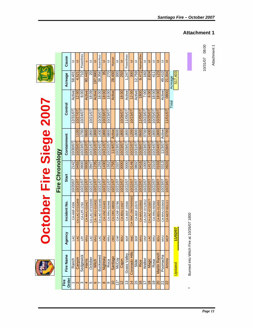
Over the years, a number of factors have contributed to this trend of disastrous fires during the fall season in Southern California, including prolonged drought conditions and more homes being built in the wildland-urban interface. (See Historical Attachments 1- 4 for additional statistical information regarding the October 2007 Fire Siege.)
Santiago Fire – October 2007
Page 11
Attachment 1
1R
anch
LAC
CA
-AN
F-43
0610
/20/
0721
4210
/30/
0712
/31/
07A
ctiv
e58
,401
UI
2C
anyo
nLA
CC
A-L
AC
-072
3184
910
/21/
0704
5510
/25/
0711
0010
/27/
0712
:00
4,52
1U
I3
Sed
gew
ick
LPF
CA
-LP
F-17
8310
/21/
0706
0010
/23/
0717
0010
/24/
076:
0071
0 P
ower
lines
4H
arris
MV
UC
A-M
VU
-010
427
10/2
1/07
0930
10/3
1/07
0600
Act
ive
90,4
40u
5O
ctob
erLA
CC
A-L
AC
-072
3200
010
/21/
0709
4710
/21/
0718
0010
/21/
0718
:09
20U
I6
Witc
hM
VU
CA
--M
VU
-010
432
10/2
1/07
1235
10/3
1/07
1800
Act
ive
197,
990
UI
7B
uckw
eed
LAC
CA
-LA
C-0
7232
185
10/2
1/07
1255
10/2
4/07
1430
10/3
0/07
18:0
038
,356
Ars
on/A
cci
8N
ight
sky
VN
CC
A-V
NC
-514
0310
/21/
0714
3010
/21/
0718
0010
/23/
0718
:00
35U
I9
Roc
aR
RU
CA
-RR
U-9
1948
10/2
1/07
1552
10/2
2/07
0800
10/2
3/07
18;0
027
0U
I10
San
tiago
OR
CC
A-O
RC
-685
5510
/21/
0717
5511
/4/0
7A
ctiv
eA
ctiv
e28
,400
Hum
an11
*M
cCoy
CN
FC
A-C
NF-
2278
610
/21/
0723
3710
/23/
0706
0030
0U
I12
Caj
onB
DU
CA
-BD
U-1
1627
10/2
2/07
0000
10/2
3/07
1800
10/2
6/07
18:0
025
0U
I
13G
rass
Val
ley
BD
FC
A-B
DF-
1056
610
/22/
0700
0010
/29/
0718
0011
/05/
07A
ctiv
e1,
247
Pow
erlin
es
14C
oron
ado
Hill
sS
MC
CA
-SM
C-2
0070
0055
9210
/22/
0701
4610
/22/
0712
0010
/23/
0712
:00
300
UI
15S
lide
BD
FC
A-B
DF-
1057
010
/22/
0708
0210
/31/
0718
00A
ctiv
e12
,759
UI
16R
ice
MV
UC
A-M
VU
-010
502
10/2
2/07
0416
10/2
8/07
0600
11/0
5/07
1800
9,47
2H
uman
/Ele
c17
Wal
ker
ON
TC
A-O
NT-
0712
912
10/2
2/07
1000
10/2
3/07
0700
10/2
3/07
7:00
160
UI
18M
agic
LAC
CA
-LA
C-0
7233
077
10/2
2/07
1417
10/2
4/07
1430
10/2
5/07
6:00
2,82
4U
I19
Ros
aR
RU
CA
-RR
U-9
2560
10/2
2/07
2310
10/2
4/07
1800
10/2
5/07
18:0
041
1U
I20
Mar
tin R
anch
BD
UC
A-B
DU
-011
653
10/2
3/07
0103
10/2
4/07
1800
10/2
5/07
18:0
012
3U
I21
Poo
mac
haM
VU
CA
-MV
U-0
1064
310
/23/
0703
1311
/3/0
7A
ctiv
eA
ctiv
e49
,410
UI
22A
mm
oM
CP
CA
-MC
P-0
0111
110
/23/
0709
2010
/28/
0707
0011
/01/
0708
0021
,004
UI
Tota
lA
crea
geU
pdat
ed
11/0
2/07
517,
403
* B
urne
d in
to W
itch
Fire
at 1
0/26
/07
1800
Con
trol
Acr
eage
Fire
Nam
eA
genc
yIn
cide
nt N
o.St
art
Oct
ober
Fire
Sie
ge 2
007
Cau
se
Fire
Chr
onol
ogy
Fire
O
rder
Con
tain
men
t
10/3
1/07
0
8:00
Atta
chm
ent 1

Santiago Fire – October 2007
Page 12
Attachment 2 Southern California Fires
Acreage Burned and Buildings Destroyed Southern California Counties
October 2007
Source: California Office of Emergency Services - Economic Development Department (State of California)
County (Fire Area) Acres Burned
Percent of Total Acres Burned
Los Angeles 104,201 20.1% Orange 28,400 5.5% Riverside 682 0.1% San Bernardino 14,331 2.8% San Diego 369,662 71.4% Santa Barbara 710 0.1% Ventura 35 0.0% Total 518,021 100.0%
County (Fire Area) Buildings Destroyed
(All)
Percent of All Buildings Destroyed
Los Angeles 61 2.0% Orange 24 0.8% Riverside 4 0.1% San Bernardino 450 14.5% San Diego 2,568 82.7% Santa Barbara 0 0% Ventura 0 0% Total 3,107 100.0%

Santiago Fire – October 2007
Page 13
Attachment 3
STATEWIDE SUMMARY OF OCTOBER 2007 FIRES SUMMARY The fires in San Diego and Los Angeles County accounted for 91.5% of the total burn area. San Diego County suffered the greatest fire-related destruction as the 369,662 acres that burned there represent 71.4% of the burn area for all seven counties. The fires destroyed 2,568 structures in San Diego County, or 82.6% of all buildings destroyed during the fires. San Bernardino County recorded the second highest number of destroyed buildings with 450, or 14.5% of all buildings destroyed. Structures destroyed in San Diego and San Bernardino counties represented 97.1% of all buildings lost in the fires. Los Angeles County The 104,201 acres burned in Los Angeles County’s six fires accounted for 20.1% of all land burned. The Ranch fire consumed more than 58,000 acres and the Buckweed fire burned 38,356 acres. The Canyon (4,500 acres), Magic (2,824 acres), October (100 acres), and Meadow Ridge (20 acres) fires charred 7,444 acres combined, destroying 28 residences and damaging another 22. The Malibu Presbyterian Church was one of two commercial buildings destroyed by the fires. Two schools (one public and one private) were among the five structures with damage. Orange County The Santiago fire burned 28,517 acres. The blaze destroyed 14 residences and damaged 8 others. Riverside County There were three separate fires in Riverside County: the Grant, Roca, and Rosa fires. The Grant fire charred one acre of land with no reported structural damage. The Rosa fire burned 411 acres and the Roca fire burned across 270 acres. Those two fires destroyed one residence and three outbuildings. San Bernardino County Of the four fires in San Bernardino County, the Slide fire caused the most destruction (12,759 acres). The Cajon, Martin, and Valley (Grass Valley) fires destroyed 250, 75, and 1,247 acres respectively; bringing the total acreage burned to 14,331. There was no damage or destruction to commercial buildings in the county, but these fires destroyed 450 residences and damaged 67 others. San Diego County There were seven fires reported in San Diego County. The Witch fire was San Diego County’s largest fire and its 197,990 acres accounted for over half of the land burned in San Diego County and 38.2% of all land burned in the seven-county fire area. The Witch fire burned 1,125 homes, 66.7% of all houses destroyed in San Diego County, and 51.6% of all residences destroyed during the fires. The fire did not burn any commercial buildings, but did destroy 499 outbuildings. An additional 77 residences and 26 outbuildings suffered damage. The Harris fire ravaged 90,440 acres. The fire did not destroy any commercial structures, but it did destroy 211 homes and 262 outbuildings. The fire caused reportable damage to 250 residences, four commercial buildings, and five outbuildings. The 50,156 acre Poomacha fire destroyed 143 residences, one commercial building, and 77 outbuildings. The Ammo fire, on the grounds of Camp Pendleton Marine Base, burned 21,004 acres. The Marine Corps did not report any structural losses. The Rice fire covered 9,472 acres and destroyed all of the structures in its path, including 206 residences, two commercial buildings, and 40 outbuildings. The Coronado Hills and McCoy fires burned 300 acres each. The Coronado Hills fire only burned undeveloped land, but the McCoy fire burned one commercial building and one outbuilding. According to the OES, 5,200 personnel were involved in firefighting in San Diego County, nearly one-half of the 11,049 personnel fighting all fires. Santa Barbara and Ventura Counties The Sedgewick fire (71) acres in Santa Barbara and the Nightsky fire (35 acres) in Ventura did not destroy or damage any structures.

Santiago Fire – October 2007
Page 14
Attachment 4

Santiago Fire – October 2007
Page 15
Fire Prevention and Community Education Land use planning and fire prevention play a key role in reducing the wildfire threat to communities in the wildland-urban interface (WUI). To adequately protect communities in these areas, a combination of brush clearance measures and ignition resistant construction of structures is necessary. Orange County has long been a leader in the creation and application of development requirements for new communities in the WUI. The Orange County Fire Authority has enforced “fuel modification” requirements since the County adopted these provisions in 1979 to protect homes in the WUI. The requirements and provisions are also included in the local ordinances of the 22 cities protected by OCFA. Unlike State law (Public Resource Code 4291) that required 30’ to 100’ of clearance in State Responsibility Areas (amended to 100’ in 2005), or to the property line if 100’ not available, fuel modification is a program consisting of creating a minimum of 170’ of zones, irrigated and non, set-backs, and selection of appropriate plant palettes for each zone. A 20’ “non-combustible zone” is included in the yards of homes adjacent to fuel modification areas where fencing, patio covers, decks, etc. must be constructed of non-combustible materials.
OCFA Fuel Modification A Zone • 20 feet wide • On level ground • Approved plant palette • Helps prevent direct flame impingement on the structure B Zone • Minimum 50 feet wide • Irrigated • Approved plant palette • Reduces fire intensity – flame length and radiant heat produced

Santiago Fire – October 2007
Page 16
C and D Zones • Minimum 50 feet wide, each zone • Remove all dead and dying materials • Native vegetation thinned 50% in C zone; 30% in D zone • Slows fire and reduces intensity by reducing fuel
Unlike the PRC requirements, OCFA’s fuel modification program contains provisions to ensure adequate space to protect structures is available before building permits are issued. If 170’ is not available, the landowner must either obtain dedicated, legal off-site easements from the adjacent property owner, or otherwise mitigate the lack of defensible space with construction that can withstand the anticipated radiant heat values. Requirements for on-going maintenance are also included in the property deed and/or Homeowners Association by-laws. Following the disastrous 1993 Laguna Beach Fire, the Orange County Board of Supervisors commissioned a report to assess the damage and make recommendations to minimize the impact of future wildfires. The subsequent report (1995) contained development requirements, including: Water supply, street design, brush clearance (current fuel modification provisions were found adequate), and construction features to “harden homes” from wildfire. The new requirements were effective on January 1, 1996, as local amendments to the California building and fire codes that went into effect that date. During the code adoption process, OCFA Fire Prevention staff worked with the building industry and requirements were modified to reduce development costs. Modifications restricted construction requirements, other than roofing, to only those homes within 100’ of the fuel modification zones if the development obtained an OCFA issued “exclusion letter”. Exclusion letters were required if the development met specified conditions, such as a full fuel modification program, adequate streets and water, two points of entry, and non-combustible roofing throughout. The application was also limited to those County areas and cities that chose to adopt the Very High Fire Hazard Severity Zones mapped by CAL FIRE (formerly California Department of Forestry and Fire Protection). The impact was minimized, particularly in those cities/areas that did not adopt the maps depicting high fire hazard zones due to concerns over insurance and other impacts. In response to California’s history of devastation from wildfire, the State recently took action to reduce the impact of future fires. State law was amended in January 2005 to require a full 100’ of brush clearance, although no guidelines were ever produced, as planned. The State also provided an interpretation that the requirements apply to Local Responsibility Area (LRA) as well as State Responsibility Area (SRA) lands. The Office of the State Fire Marshal worked with stakeholders and UC Berkley’s fire lab to develop new “ignition resistant” building standards and testing criteria. Although

Santiago Fire – October 2007
Page 17
these regulations were adopted, the effective date was delayed to give builders time to find products and revise financial documents. They are effective in SRA Jan 2008 and in LRA July 2008. See Fire Prevention and Community Education Section Attachment 1 for a comparison of OCFA’s current requirements to the regulations adopted by the State Building Standards Commission in 2006 and effective in 2008. These new provisions go into effect in State Responsibility Areas (SRA) designated by the Director of CAL FIRE as Very High, High, and Moderate Fire Hazard Severity Zones, in January, 2008. The effective date in local responsibility areas (LRA) is July 2008 for areas designated as Very High Fire Hazard Severity Zone only. Individual cities may elect to adopt High and Moderate Fire Hazard Severity Zones as local WUI areas for application of the ignition resistant structure protection measures. OCFA Fire Prevention staff is planning to encourage partner cities to designate these areas. The provisions for fuel modification and structure protection that have evolved over the past 30 years, although proven effective in protecting communities during wildfire incidents, are not without implementation challenges. The most significant implementation challenges are as follows: • Maintenance of Fuel Modifications
Fuel modification provisions in place in communities developed since 1980 and brush clearance measures in those developed prior to that time must be maintained to be effective. Currently OCFA does not have a formal inspection and enforcement program to ensure the over 14,000 parcels and lots are adequately maintained. As a result, areas can become overgrown and, in some instances, irrigation can be stopped due to cost or poor maintenance of water lines. OCFA staff attempts to identify the worst cases and work with landowners to restore the land to an approved condition. Due to lack of penalties for failure to comply, several parcels and lots continue out of compliance for several years presenting a hazard to community homes and adjoining lands. For example, the Foothill Ranch HOA was out of compliance with their approved fuel modification plans for several years and received their approval letter two days prior to the Santiago Fire.
• Application of Construction Requirements
The application of ignition resistant construction requirements is critical to the survivability of homes that are subject to ember intrusion hundreds of feet from the interface. Maps depicting impact areas must be locally adopted and the process is also politicized as the development community expresses concern over costs, real estate disclosure, and insurance. As a result, areas shown to need the protection, based on topography, fuels, weather and fire history, are too often left unmapped due to local action.
• Existing Communities The most significant challenge is protecting the many communities established prior to current fuel modification and construction requirements. These older, established communities lack adequate brush clearance. Following, an aggressive

Santiago Fire – October 2007
Page 18
education and outreach program (described under Community Education below), OCFA Fire Prevention staff recruited and trained Reserves and several at-risk youths from Vision Quest to assist in completing over 14,000 inspections for adequate fuel modification and brush clearance. Over 740 compliance orders were issued and re-inspections were underway in September, 2007. In addition to difficulty encouraging homeowners to take action to clear brush, there are many areas where lots are too small to create adequate defensible space on their property and homeowners cannot obtain permission for off-site clearance from neighbors or government entities. Environmental restrictions also hinder the ability to create defensible space as both State and Federal agencies have conflicting missions with the fire service relative to control of native vegetation. The homes are also older and were built before requirements to protect them were in place. The following communities have been identified as being at higher risk of conflagration type fire due to construction of homes, lack of fuel modification protecting the community (developed pre-1980), and type of fuel and topography. These areas have also been identified by CAL FIRE as being in fire hazard zones.
OCFA communities that have been identified as being at high risk
• Silverado Canyon • Baker Canyon • Black Star Canyon • Modjeska Canyon • Trabuco Canyon • Santiago Canyon • Ortega Hwy (and vicinity) • Lemon Heights/ Cowan Heights/ North Tustin areas • Tustin Heights Unincorporated • Emerald Bay • Coastal Canyons in San Clemente • Turtle Rock (Irvine) • The Forest (Lake Forest) • Pacific Island 1, 2 and 3 (top of Pacific Island Drive, Laguna Niguel)
Community involvement has proven to have a positive impact in these older developments. Orange County has two Fire Safe Councils, with one in Laguna Beach and the other incorporating the inland canyon areas of Silverado, Modjeska and adjoining canyons. The Inter-Canyon Fire Safe Council played a significant role before, during and after the Santiago Fire. The Councils work year-round, particularly in Modjeska, Williams, Baker and Santiago, to clear brush and increase awareness of wildfire hazards, encourage preparation measures, and practice evacuation procedures. In addition, their annual Canyon Clean Sweep (in conjunction with OCFA) and public awareness campaigns assisted in cutting and clearing additional brush and removing combustible materials from several properties, although many common areas and private lands lacked adequate clearance.

Santiago Fire – October 2007
Page 19
During the Santiago Fire the Silverado and Modjeska Fire Plans, developed by OCFA Operations Department staff with significant stakeholder involvement (O.C. Sheriff, Animal Control, residents, and the Equestrian Trails, Inc.), were used as reference documents that assisted in the safe evacuation of residents and animals in these two communities. However, 14 homes were completely destroyed, and a combination of heavy vegetation and combustible construction likely played a contributing role. OCFA and our partner cities have no formal program for preventative protection of these areas and the enforcement element is lacking in effectiveness. The fuel modification zones, created when the communities of Foothill Ranch and Portola Hills in the City of Lake Forest, and Portola Springs in Irvine were designed and developed, helped to protect homes in these communities from this fast moving fire. With the intensity of the fire significantly reduced as flames neared homes, firefighters were able to extinguish the fire as they stood in the relative safety of the “A Zone” (defensible space). Combined with ignition resistant building construction features of homes in these communities, the result was that no homes were destroyed and firefighters were able to more safely protect these homes with fewer resources than would have been required had the brush and home construction measure not been required and in place. The additional resources were available for firefighting and structure protection in communities that lacked adequate defensible space and “hardening” of the homes from flame and ember intrusion. COMMUNITY EDUCATION OCFA Community Education, Fire Prevention and Operations staff took an active role in educating the public about wildfire hazards and the need for adequate preparation. Efforts included publication and distribution of three safety bulletins and educational outreach regarding wildfire preparedness and preparation encompassing defensible space, fuel modification, smoke in the air, and hardening the home. The programs consisted of discussion and PowerPoint presentations at special community events including the Villa Park Pancake Breakfast, Orange County Fair, San

Santiago Fire – October 2007
Page 20
Clemente Street Fair, and OCFA’s Open House reaching more than 13,000 people. Target audiences were communities that were located close to or around areas of moderate to high vegetation. Staff distributed more than 6,000 fliers to interface city halls, fire stations, water districts, and local stores for Aliso Viejo, Dana Point, Irvine, Laguna Hills, Laguna Niguel, Laguna Woods, Lake Forest, Mission Viejo, Placentia, Rancho Santa Margarita, San Clemente, San Juan Capistrano, Tustin, Villa Park, and Yorba Linda. In addition, close to 600 individual homeowners and 20 associations, along with their property management companies received customized education and brush maintenance prescriptions for their properties. The high risk canyon areas received special attention from Operations crews and Fire Prevention Staff, including Canyon Clean Sweep, Silverado’s Fire & Ice Town Hall Meeting, and Modjeska’s Town Hall meeting. Field personnel from stations located in canyon areas went door-to-door, delivering over 2,000 preparedness flyers in addition to leading a Canyon Preparedness Academy (CEPA) at Fire Station 16 in Modjeska Canyon. In late June, 2007, local area full-time Firefighters, Reserve Firefighters from canyon areas, OCFA Fire Explorers and OC Sheriff’s Deputies, canvassed each canyon community over a 3-day period handing informational flyers and related material to each homeowner in Silverado, Williams, Trabuco and Modjeska Canyons.

Santiago Fire – October 2007
Page 21
Attachment 1 COMPARISON OF CURRENT OCFA REQUIREMENTS AND NEW STATE REGULATIONS
California Building Code Requirements for “Hardening Homes”
(* indicates more restrictive requirement if not equivalent)
Current OC Ordinance (Jan 1996) New State Code (July 2008) Applies to structures located in Very High Fire Hazard Severity Zones and Special Fire Protection Areas that are within 100’ of fuel modification zones. Most provisions apply only to structures which have an exposed side. Exposed side is defined as exterior wall of a structure which is within 100 ft. of the fuel modification zone.
Provisions apply to all structures located in the Very High Fire Hazard Severity Zones and locally designated Wildland Fire Area. Applies to all exterior sides and not just the exposed sides shall meet the requirements of chapter 7A.*
Exterior wall: Exposed side of exterior wall shall be of non combustible construction or 1-hour fire-resistive construction for the exterior portion.
Exterior wall: shall be of approved non-combustible or ignition resistant material or heavy timber.
Openings: Glazed openings shall be multi-glazed with at least two panes.
Openings: Glazed openings shall be tempered glass or glass block or have a fire resistive rating of not less than 20 minutes.*
Doors: Doors shall be minimum 1 3/8" thick solid core or metal non-combustible.
Doors: Doors shall be non combustible or solid core or 20 minutes rated.
Attic vents: Not allowed on exposed sides. On other sides must be protected by metal louvers and 1/4" mesh corrosion resistant metal screen, vents shall not exceed 144 sq. inch per opening.*
Attic vents: The vents shall be covered with 1/4" corrosion resistant metal screen; no size limit.
Eave or Cornice Vents: Not allowed on the exposed sides.
Eave or Cornice Vents: Prohibited unless they can resist the intrusion of flame and burning embers into the attic.
Roof Valley: Valley flashing shall not be less than 26 ga galvanized sheet installed over a 36 inch under layment consisting of one layer of No. 72 ASTM cap sheet running the full length of valley
Roof Valley: Valley flashing shall not be less than 26 ga galvanized sheet installed over a 36 inch under layment consisting of one layer of No. 72 ASTM cap sheet running the full length of valley
Roof gutters: Roof gutters shall be provided with means to prevent accumulation of leaves and debris.
Roof gutters: Roof gutters shall be provided with means to prevent accumulation of leaves and debris.
Roof Assembly: New construction and reconstruction shall be fire retardant Class A roof assembly.
Roof Assembly: New construction and reconstruction shall be Class A roof assembly
Skylights: Skylights shall have a non-combustible frame with dual glazing of heat strengthened or fully tempered glass or 3/rated assembly.*
Skylights: No requirements
Roof covering: Where roof profile allows a space between roof covering and roof deck the space shall be fire stopped with approved material or have one layer of No. 72 ASTM cap sheet installed over the combustible decking
Roof covering: Where roof profile allows a space between roof covering and roof deck the space shall be fire stopped with approved material or have one layer of No. 72 ASTM cap sheet installed over the combustible decking.
Decking: Decks on exposed side to be one-hour rated, non-combustible or heavy timber.
Decking: Specific requirement for decking surface shall be of ignition resistant material or heavy timber or non combustible material.
Ignition resistant material definition provided: Tested according to ASTM 84 for 30 minutes
Flame spread less than 25 with evidence of no progressive combustion.

Santiago Fire – October 2007
Page 22
PAGE INTENTIONALLY LEFT BLANK

Santiago Fire – October 2007
Page 23
Advance Planning In anticipation of fire season, the OCFA launched additional public outreach programs last spring, which included working with homeowners, landowners, and other agencies in the following areas: • Evaluation of the highest-risk areas • Canyon clean-ups • Town Hall meetings in the canyon areas • Community education bulletins and events • Enhanced enforcement program of defensible space and fuel modification zones • Additional caches of firefighting tools on standby
To be proactive to periods of extreme weather, OCFA routinely monitors weather forecasts and takes actions commensurate with these forecasts and predictions. OCFA has a comprehensive Standard Operating Procedure (SOP) titled Extreme Weather Plan Winds/Red Flag & Rain/Floods (OM 209.13). This SOP provides a standardized operational approach in response to extreme or predicted extreme weather conditions. (See Advance Planning – Attachment 1.) Additionally, OCFA has an SOP titled Red Flag Alert/Hazardous Fire Conditions Program (OM 209.12). This SOP describes the Red Flag Alert Program which is designed to prevent large fires that may occur as a result of extreme weather conditions, and OCFA’s actions in response to Red Flag Alerts that are issued by the U.S. Weather Service. Essentially, this program is an intensive, cooperative, watch-and-warning fire prevention patrol, and public awareness program conducted by local, state, and federal fire agencies in conjunction with private cooperators during periods of extreme fire danger. (See Advance Planning – Attachment 2.) Beginning as early as October 16th, weather forecasters were predicting Santa Ana winds for Southern California. On October 18th, a Fire Weather Watch was issued by the National Weather Service for strong Santa Ana conditions beginning on Sunday, October 21st. A Fire Weather Watch means that critical fire weather conditions are forecasted to occur. These advanced weather forecasts indicated a period of strong Santa Ana winds would occur Sunday, October 21st through Tuesday, October 23rd over most of southwest California. Upon notification of the Fire Weather Watch, OCFA Operations Department staff began planning for augmented staffing and incrementally implemented portions of the Extreme Weather Plan/Winds SOP. Additional augmented staffing was identified for the weekend of October 19-21.

Santiago Fire – October 2007
Page 24
Augmented/Additional Staffing October 19
• 1 Pre-staged Type 1 Engine Strike Team w/ 3-person Staffing October 20
• 1 Pre-staged Type III Wildland Engine Strike Team w/4-person staffing • 1 Pre-staged Type 1 Engine Strike Team w/4-person Staffing • 1 Bulldozer • 1 Handcrew
October 21 • 1 Pre-staged Type III Wildland Engine Strike Team with 4-person staffing • 1 Pre-staged Type I Engine Strike Team w/4-person staffing • All Reserve staffed Engines (5), Patrols (10), Squads (3) & Water Tenders (4) were
hard covered at their respective stations • 1 Bulldozer • 1 Handcrew • 2 Dispatchers and 1 Dispatch Supervisor • 1 Incident Management Team consisting of 7 Chief Officers • 1 Command Bus with driver • 1 Support Dispatcher to So. Ops to assist
As the Santa Ana wind condition worsened overnight on Saturday, October 20th, and because there were two major fires, and several less serious fires already burning out-of-control in Southern California, OCFA’s Chief of Operations mandated that all suppression personnel scheduled to go off-shift at 8:00 a.m. on Sunday, October 21st be held on-duty. This action increased manpower available to staff emergency apparatus from normal daily staffing of 253 personnel to 462 suppression personnel. Further direction was given to begin outfitting and staffing all available relief engines and training engines.
Apparatus
Baseline/daily staffing and
resources Firefighters
Event staffing and resources
deployed Firefighters BLS engines (3) 34 102 2 6 BLS engines (4) 78 312 ALS engines (4) 19 76 13 52 Trucks (4) 10 40 14 56 Trucks (3) 3 9 Medic Vans (2) 13 26 18 36 Total 79 253 125 462 Total Engines Normal Deployment 53 Event Deployment 93 Increase 75%

Santiago Fire – October 2007
Page 25
Staffing on all Type III wildland engines was increased from 3 to 4 personnel, and staffing on OCFA’s three 3-person truck companies was increased to 4 persons. Reserve personnel were directed to hard cover (staff) all engines, patrols, squads, and water tenders at their respective stations, as well as the helicopter support unit at Station 41 (Fullerton Airport). In addition, some key paramedic engine companies were reconfigured to BLS engines, with paramedics moving to paramedic vans (relief units) to maintain EMS coverage while making engine companies more available for fire response. A concerted effort was made to increase surge capacity as much as possible and as quickly as possible in anticipation of worsening extreme weather conditions and regional fire activity. Service Center and Automotive Section personnel were recalled to duty and worked throughout the day on Sunday, October 21st outfitting and checking relief engines as they were placed into service. Crews were assembled and sent to various locations to begin staffing these additional units. This decisive command action led to staffing 26 additional engines. Service Center staff had also been preparing OCFA’s wildland cache of extra equipment and supplies for response if needed. Coincidentally, OCFA had recently purchased 16 new engines and was in the process of rotating and replacing engines, with older ones eventually being destined for surplus. Two of the engines being rotated were unavailable for use due to major mechanical problems. However, the other 14 were placed into service and staffed. Essentially, this meant that at the time the fire occurred, OCFA had 14 more Type I engines available (over and above the normal relief fleet and training engines) to be put in-service than would normally be available. Most of these additional engines were outfitted, staffed, and placed in-service in less than 8 hours. Some required more time to be outfitted as they had no equipment compliment or required some level of automotive safety check prior to being used, but all additional engines were in-service by early Monday afternoon. As a result of this aggressive action, 40 additional engines (the equivalent of 8 Strike Teams) were placed into service. Considering the delay in receiving out-of-area Mutual Aid engines, the actions to staff virtually every available engine greatly enhanced the “surge capacity” for the Santiago Fire and was a major factor in saving lives, homes, and property. In addition to the 40 extra engines that were staffed by full-time firefighters, OCFA Reserve personnel staffed 10 Patrols, 3 Squads, 4 Water Tenders, 1 Helicopter Support Unit, and 5 Engines (at stand alone Reserve Stations 3, 11, 14, 16, and combination Station 23). The staffing level in the Emergency Communications Center (ECC) was augmented with 2 additional dispatchers and 1 additional dispatch supervisor. Staffs were recalled to begin staffing the Department Operation Center (DOC) at about 11:00 a.m. in anticipation of worsening conditions, and the Corporate Communications Battalion Chief was on-call for public information officer and media related activities. In fact, the Corporate Communications Battalion Chief had just sent an advisory to OCFA’s Board of Directors regarding the extreme weather conditions and augmented staffing, when the Santiago Fire occurred.

Santiago Fire – October 2007
Page 26
Throughout the day on Sunday, Reserve-staffed Patrols and Squads were assigned by local area Battalion Chiefs to conduct Red Flag patrols of high hazard fire areas, and the Orange County Sheriff’s Department had increased their patrol activities in these same areas. One of these Reserve-staffed Patrol units (Patrol 21 – Tustin area) was on patrol at the time the fire was reported, and was one of the first two units to arrive on-scene. The pre-staged Incident Management Team (7 Chief Officers) that had been activated for the day, met and reviewed various pre-fire plan documents, such as the Silverado Fire Plan and the Modjeska Fire Plan. These are pre-fire planning documents that have been previously developed for high risk wildland-urban interface areas. These plans were developed by OCFA staff with input from other affected agencies (i.e. Sheriff’s Department, Animal Control, Fire Safe Councils) and various stakeholders. The advance review of these particular pre-fire plan documents, proved to be very important, when later, key elements of them were implemented during the various stages of the fire. The advance planning done for the predicted extreme weather event, and the staffing actions taken early Sunday morning, proved to be very wise and proactive decisions. Nine major fires and other smaller fires in four southland counties were already burning out-of-control prior to the start of Santiago Fire. Thousands of residents were being evacuated and homes were being lost on at least five of these major fires. Firefighting resources throughout the Southern California region were already being overwhelmed battling these blazes, with resources rapidly becoming scarce. OCFA’s advance planning and staffing was instrumental in developing a surge capacity that significantly enhanced the initial response to the Santiago Fire, and provided much more than the normal amount of firefighting resources from within the Orange County Operational Area to battle the fire. This action helped to compensate for the lack of out-of-area Mutual Aid resources during the first 48+ hours of the incident. Without this level of advance planning and aggressive staffing of additional apparatus, it’s likely that during the critical early stages of the fire, many more residents would have been in harm’s way, and more homes would have been lost or damaged due to a lack of resources. In addition to the advance planning that had been done for the extreme weather event, and additional staffing actions that occurred for Sunday, OCFA also responded to a request for Mutual Aid engines to Los Angeles County early in the morning (prior to the Santiago Fire). OCFA and the other fire departments in the Orange County Operational Area, combined to send 7 Strike Teams of five engines each in response to this request (3 from OCFA, 3 from other O.C. departments, and 1 combined Strike Team of OES engines staffed by personnel from OCFA and other Orange County area fire departments). These Strike Teams were assigned to the Canyon Fire in Malibu. Shortly after the Santiago Fire started, 4 of these Strike Teams were released back to Orange County,

Santiago Fire – October 2007
Page 27
and were filling assignments on the fire by midnight Sunday. Two others remained actively committed in Los Angeles County until early Tuesday morning, at which time they were released, returned to Orange County and were assigned to the Santiago Fire by 8:30 a.m. the same day. The OES Strike Team was released from the Canyon Fire in Malibu in the early evening on Tuesday, October 23rd and reassigned to the Witch Fire in San Diego County, where it remained assigned until released to return home on October 30th. At approximately 5 p.m. on Sunday, October 21st (prior to the start of the Santiago Fire) OCFA provided 5 engines, 2 truck companies and 1 Division Chief via a Fire Chief to Fire Chief Mutual Aid request to cover stations for the Los Angeles County Fire Department due to their drawdown and depletion of local resources. One of the truck companies was released back to Orange County Sunday night, and the remainder of the equipment was released and returned by 1:30 p.m. on Monday, October 22nd.

Santiago Fire – October 2007
Page 28
Attachment 1 ORANGE COUNTY FIRE AUTHORITY Page 1 of 2 OM 209.13 STANDARD OPERATING PROCEDURES 6/16/06 REVISED
2 ATTACHMENTS TACTICAL PLAN EXTREME WEATHER PLAN/WINDS/ RED FLAG & RAIN/FLOODS INTENT This procedure provides guidelines for standardized operational procedures in response to changes that occur due to extreme or predicted extreme weather conditions. All personnel are expected to make every effort to assist in the implementation of the actions for which they have some level of responsibility. The phased plans will be based on local weather conditions and activity levels. PROCEDURE Data Sources The ECC supervisor will ensure that periodic RAWS weather data is compiled and field weather data is gathered from stations throughout the County, such as Stations 15, 53, and 45. This weather information, along with updates from the National Weather Service, will be used to determine local weather conditions. Local weather conditions, along with regional, area, and local activity levels, will be used to determine the most appropriate implementation levels. Strong Winds or Red Flag Plan - Severe Fire Weather LEVEL I Local winds are sustained at 30 mph or greater, moderate emergency
activity level and a potential for increased fire spread. LEVEL II Local winds are sustained at 40 mph or greater, or a Red Flag Warning
has been issued, or moderate to high emergency activity level within the area or region and a potential for moderate commitment of out-of-area resources.
LEVEL III Local winds are sustained at 50 mph or greater, or Red Flag Alert has
been issued, or high emergency activity level within the area with several large fires within the region and a large commitment of out-of-area resources with the potential to bring the area to “draw-down” levels.
LEVEL IV Local winds are sustained at 60 mph or extremely high emergency
activity level within the area with several major fires within the region

Santiago Fire – October 2007
Page 29
and a heavy commitment of out-of-area resources bringing the area to draw-down levels.
Heavy Rains or Potential Flooding Conditions LEVEL I Rapid accumulation of rain, up to 2 inches, in a short period of time;
minor localized flooding in streets and low areas, low to moderate water levels in flood channels and a low probability of water rescues.
LEVEL II Continuous rain of 2” to 3”, or two major rainstorms within 24 hours;
with a potential for moderate localized flooding, moderate to high water levels in flood channels and moderate potential for water rescues.
LEVEL III Continuous rain of 3” or greater, or several major rainstorms within 24 to
36 hours; with high accumulations of rain, localized flooding, potential for water run-off to overflow flood channels, potential for evacuations and a high probability of water rescues.
LEVEL IV Heavy rains for several days; with flood channels overflowing, localized
flooding and mud slides, some areas being evacuated and water rescues occurring throughout the County.
Plan Implementation/Termination Using the criteria described in this plan and other available information, the plan can be implemented in whole or in part and will remain in effect at the discretion of the Duty Officer.

Santiago Fire – October 2007
Page 30
Atta
chm
ent 1
LEVE
L - A
LL
ECC Supervisor
ECC
Duty Officer & OPS Chief
Division Chiefs
ECC BC
EPAC BC
Special Operations BC
Training BC
Battalion Chiefs
Company Officers
Weather Coordinator
Corporate Communications BC/PIO
Fleet Services Manager
Purchasing Manager
Not
ify D
uty
Offi
cer,
EP
AC
BC
, and
EC
C B
C w
hen
cond
ition
s m
eet L
evel
I, II
, III
or IV
cr
iteria
; or
a R
ed F
lag
War
ning
has
bee
n is
sued
or R
ed F
lag
Ale
rt ha
s be
en
decl
ared
.A
ll
Adv
ise
Exe
cutiv
e M
anag
emen
t, D
ivis
ion
Chi
efs,
all
BC
s, C
rew
s an
d E
quip
men
t, an
d P
IO if
/whe
n an
y of
the
vario
us le
vels
of t
he p
lan
are
impl
emen
ted
by th
e D
uty
Offi
cer.
All
Del
iver
gen
eral
ann
ounc
emen
ts to
fiel
d pe
rson
nel r
egar
ding
Ext
rem
e W
eath
er P
lan
Leve
l cha
nges
.A
ll
Pla
ce O
CFA
in a
Hig
h W
ater
shed
Dis
patc
h Le
vel a
nd a
dvis
e ot
her f
ire a
genc
ies
in
the
oper
atio
nal a
rea.
1
Det
erm
ine
avai
labi
lity
ofal
lChi
efO
ffice
rs(A
Cs,
DC
s,S
taff
&Fi
eld
BC
s),a
dvis
eth
eD
uty
Offi
cer,
and
mai
ntai
n a
curr
ent l
ist f
or th
e du
ratio
n of
the
plan
.2
Con
firm
imm
edia
tere
spon
seav
aila
bilit
yof
Fire
Com
man
d2,
and
Logi
stic
san
dC
omm
unic
atio
n Tr
aile
r.2
Det
erm
ine
leve
l of i
mpl
emen
tatio
n ne
cess
ary.
1C
onsi
der s
taffi
ng s
tand
-alo
ne R
eser
ve s
tatio
ns.
1C
ontin
ue L
evel
I ite
ms
and
appr
ove
impl
emen
tatio
n of
Lev
el II
Mod
ifica
tions
.2
Con
side
r ide
ntify
ing
an In
cide
nt M
anag
emen
t Tea
m o
n pa
per
2Au
thor
ize
EC
C s
taff,
PIO
s, S
afet
y O
ffice
rs, M
echa
nics
, Ser
vice
Cen
ter s
taff
to b
e pl
aced
“on-
call”
as
need
ed.
2
Iden
tify
staf
f tha
t will
resp
ond
to C
ity/C
ount
y E
OC
s an
d ad
vise
EC
C.
2C
ontin
ue L
evel
II it
ems
and
appr
ove
impl
emen
tatio
n of
the
Leve
l III
Mod
ifica
tions
.3
Pla
ce a
n In
cide
nt M
anag
emen
t Tea
m o
n-ca
ll w
ith v
ehic
les
(adv
ise
EC
C,
conf
irm/n
otify
IMT
mem
bers
).3
Sta
ff th
e af
fect
ed C
ity/C
ount
y E
OC
s as
requ
ired
and
advi
se E
CC
.3
Sta
ff al
l Typ
e III
eng
ines
with
car
eer p
erso
nnel
and
hire
bac
k to
sta
ff Ty
pe I
Eng
ines
.3
C
ontin
ue L
evel
III i
tem
s an
d ap
prov
e im
plem
enta
tion
of L
evel
IV M
odifi
catio
ns.
4D
ecen
traliz
e op
erat
ions
bas
ed o
n ac
tivity
leve
ls.
4D
isco
ntin
ue E
mer
genc
y M
edic
al D
ispa
tch
(EM
D),
if ne
cess
ary.
4
Iden
tify
addi
tiona
l EC
C s
taff
avai
labi
lity.
2S
taff
addi
tiona
l EC
C p
erso
nnel
with
app
rova
l fro
m D
uty
Offi
cer.
3Id
entif
y st
aff t
o re
spon
d to
the
DO
C, i
f act
ivat
ed.
1A
ctiv
ate
the
DO
C to
Lev
el I
and
advi
se E
CC
.2
Ser
ve a
s th
e ce
ntra
l coo
rdin
atio
n po
int f
or g
athe
ring,
ana
lyzi
ng, a
nd d
isse
min
atin
g em
erge
ncy
info
rmat
ion
inte
rnal
ly a
nd e
xter
nally
.2
Mai
ntai
n an
d di
spla
y cu
rren
t and
acc
urat
e in
cide
nt s
ituat
ion
and
reso
urce
sta
tus
info
rmat
ion.
2
Act
ivat
e th
e D
OC
to L
evel
II a
nd a
dvis
e E
CC
.3
Coo
rdin
ate
oper
atio
nal a
rea
Fire
and
Res
cue
Mut
ual A
id a
nd o
ther
reso
urce
re
ques
ts.
3
OC
FA E
xtre
me
Wea
ther
Pla
n - H
igh
Win
ds a
nd R
ed F
lag
LEVE
L 3
- Loc
al w
inds
are
sus
tain
ed a
t 50
mph
or g
reat
er, o
r Red
Fla
g A
lert
has
bee
n is
sued
, or h
igh
emer
genc
y ac
tivity
leve
l with
in th
e ar
ea w
ith s
ever
al la
rge
fires
with
in th
e re
gion
, or a
larg
e co
mm
itmen
t of o
ut-o
f-are
a re
sour
ces
with
the
pote
ntia
l to
brin
g th
e ar
ea to
"dr
aw-d
own"
leve
ls.
LEVE
L 4
- Loc
al w
inds
are
sus
tain
ed a
t 60
mph
, or e
xtre
mel
y hi
gh e
mer
genc
y ac
tivity
leve
l with
in th
e ar
ea w
ith s
ever
al m
ajor
fire
s w
ithin
the
regi
on a
nd a
hea
vy c
omm
itmen
t of o
ut-o
f-are
a re
sour
ces
brin
ging
the
area
to "
draw
-dow
n" le
vels
.
LEVE
L 1
- Loc
al w
inds
are
sus
tain
ed a
t 30
mph
or g
reat
er, m
oder
ate
emer
genc
y ac
tivity
leve
l and
a p
oten
tial f
or in
crea
sed
fire
spre
ad.
LEVE
L 2
- Loc
al w
inds
are
sus
tain
ed a
t 40
mph
or g
reat
er, o
r Red
Fla
g W
arni
ng h
as b
een
issu
ed, o
r mod
erat
e to
hig
h em
erge
ncy
activ
ity le
vel w
ithin
the
area
or r
egio
n an
d a
pote
ntia
l for
mod
erat
e co
mm
itmen
t of o
ut-o
f-are
a re
sour
ces.
Pag
e 1
of 2
3/11
/200
8

Santiago Fire – October 2007
Page 31
Atta
chm
ent 1
LEVE
L - A
LL
ECC Supervisor
ECC
Duty Officer & OPS Chief
Division Chiefs
ECC BC
EPAC BC
Special Operations BC
Training BC
Battalion Chiefs
Company Officers
Weather Coordinator
Corporate Communications BC/PIO
Fleet Services Manager
Purchasing Manager
OC
FA E
xtre
me
Wea
ther
Pla
n - H
igh
Win
ds a
nd R
ed F
lag
LEVE
L 3
- Loc
al w
inds
are
sus
tain
ed a
t 50
mph
or g
reat
er, o
r Red
Fla
g A
lert
has
bee
n is
sued
, or h
igh
emer
genc
y ac
tivity
leve
l with
in th
e ar
ea w
ith s
ever
al la
rge
fires
with
in th
e re
gion
, or a
larg
e co
mm
itmen
t of o
ut-o
f-are
a re
sour
ces
with
the
pote
ntia
l to
brin
g th
e ar
ea to
"dr
aw-d
own"
leve
ls.
LEVE
L 4
- Loc
al w
inds
are
sus
tain
ed a
t 60
mph
, or e
xtre
mel
y hi
gh e
mer
genc
y ac
tivity
leve
l with
in th
e ar
ea w
ith s
ever
al m
ajor
fire
s w
ithin
the
regi
on a
nd a
hea
vy c
omm
itmen
t of o
ut-o
f-are
a re
sour
ces
brin
ging
the
area
to "
draw
-dow
n" le
vels
.
LEVE
L 1
- Loc
al w
inds
are
sus
tain
ed a
t 30
mph
or g
reat
er, m
oder
ate
emer
genc
y ac
tivity
leve
l and
a p
oten
tial f
or in
crea
sed
fire
spre
ad.
LEVE
L 2
- Loc
al w
inds
are
sus
tain
ed a
t 40
mph
or g
reat
er, o
r Red
Fla
g W
arni
ng h
as b
een
issu
ed, o
r mod
erat
e to
hig
h em
erge
ncy
activ
ity le
vel w
ithin
the
area
or r
egio
n an
d a
pote
ntia
l for
mod
erat
e co
mm
itmen
t of o
ut-o
f-are
a re
sour
ces.
Mai
ntai
n co
mm
unic
atio
n an
d co
ordi
natio
n w
ith O
ES
Re g
ion
I, C
DF,
US
FS, R
SS
, and
ot
her o
utsi
de a
genc
ies
and
depa
rtmen
ts.
3
Coo
rdin
ate
info
rmat
ion
betw
een
OC
FA D
OC
and
City
/Cou
nty
EO
Cs.
3E
stab
lish
and
mai
ntai
n A
genc
y Li
aiso
n fu
nctio
ns th
at in
volv
e O
CFA
, cou
nty,
or
Mas
ter M
utua
l Aid
reso
urce
s.3
Pro
vide
coo
rdin
atio
n to
exp
ande
d em
erge
ncy
inci
dent
s to
ens
ure
rapi
d an
d ap
prop
riate
logi
stic
al s
uppo
rt.
3
Act
ivat
e th
e D
OC
to L
evel
III.
4P
lace
two
(2) h
elic
opte
rs in
ser
vice
; sta
ged
at F
ulle
rton
Airp
ort
and
chec
k on
the
avai
labi
lity
of a
law
enf
orce
men
t hel
icop
ter f
or o
bser
vatio
n an
d/or
wat
er d
ropp
ing.
1
Con
firm
hel
icop
ter s
uppo
rt cr
ew a
vaila
bilit
y re
spon
ding
from
hom
e.2
Hel
icop
ter F
uel T
ende
r and
Sup
port
vehi
cles
sta
ffed
with
Res
erve
and
sta
ged
with
he
licop
ters
.3
Sta
ff al
l doz
ers
and
stra
tegi
cally
dep
loy
for I
nitia
l Atta
ck.
3C
heck
ava
ilabi
lity
of h
and
crew
for i
mm
edia
te re
spon
se o
r stra
tegi
c re
-dep
loym
ent
for i
nitia
l atta
ck.
3
Sta
ffad
ditio
nalS
afet
yO
ffice
rsan
dde
ploy
asdi
rect
edby
the
Dut
yO
ffice
r,an
dad
vise
EC
C.
3
Ens
ure
“Rel
ief
Veh
icle
Sta
tus”
onth
eO
CFA
Intra
net
iscu
rren
tfo
ral
lun
itsan
dco
nfirm
that
relie
f/res
erve
equ
ipm
ent i
s pr
epar
ed to
be
plac
ed in
ser
vice
.1
Sta
ff/ha
rd-c
over
engi
neat
sele
cted
stan
d-al
one
Res
erve
stat
ions
with
wild
land
inte
rface
thre
at (e
.g. 3
, 11,
14,
16)
as
dire
cted
by
Dut
y O
ffice
r.2
Sta
ff R
eser
ve p
atro
l/squ
ad u
nits
per
Red
Fla
g H
andb
ook
to m
onito
r loc
al w
eath
er
cond
ition
s an
d to
pro
vide
hig
h vi
sibi
lity
in w
ildla
nd in
terfa
ce a
reas
. 2
Con
vert
pre-
desi
gnat
edm
edic
engi
nes
tom
edic
vans
and
hire
back
pers
onne
lto
staf
f as
regu
lar e
ngin
es w
ith th
ree
(3) p
erso
nnel
.3
Sta
ff w
ater
tend
ers
with
two
(2) R
eser
ves.
3S
taff
all
patro
ls/s
quad
sw
ithm
inim
umof
thre
e(3
)R
eser
ves.
Use
patro
lsto
supp
lem
ent e
xist
ing
Red
Fla
g pa
trols
.3
Sta
ff ba
ttalio
n re
lief/r
eser
ve e
ngin
es, a
s di
rect
ed b
y th
e D
uty
Offi
cer.
3P
rovi
depe
riodi
cw
eath
erup
date
sto
Exe
cutiv
eM
anag
emen
t,D
uty
Offi
cer,
Div
isio
nC
hief
s, E
PA
C B
C, a
ll B
Cs,
EC
C, C
rew
s an
d E
quip
men
t, an
d P
IO.
1
Ens
ure
NW
Sin
form
atio
nan
dfie
ldw
eath
erda
tais
gath
ered
,m
onito
red,
and
diss
emin
ated
to a
ppro
pria
te lo
catio
ns/in
divi
dual
s.2
Iden
tify
avai
labi
lity
ofP
IOs
for
imm
edia
tere
spon
seto
med
iace
nter
and
toin
cide
nts
and
advi
se E
CC
. 2
Det
erm
ine
avai
labi
lity
of s
taff
and
advi
se E
CC
of c
onta
ct in
form
atio
n.2
Det
erm
ine
avai
labi
lity
of S
ervi
ce C
ente
r sta
ff an
d ad
vise
EC
C o
f con
tact
info
rmat
ion.
2
Pag
e 2
of 2
3/11
/200
8
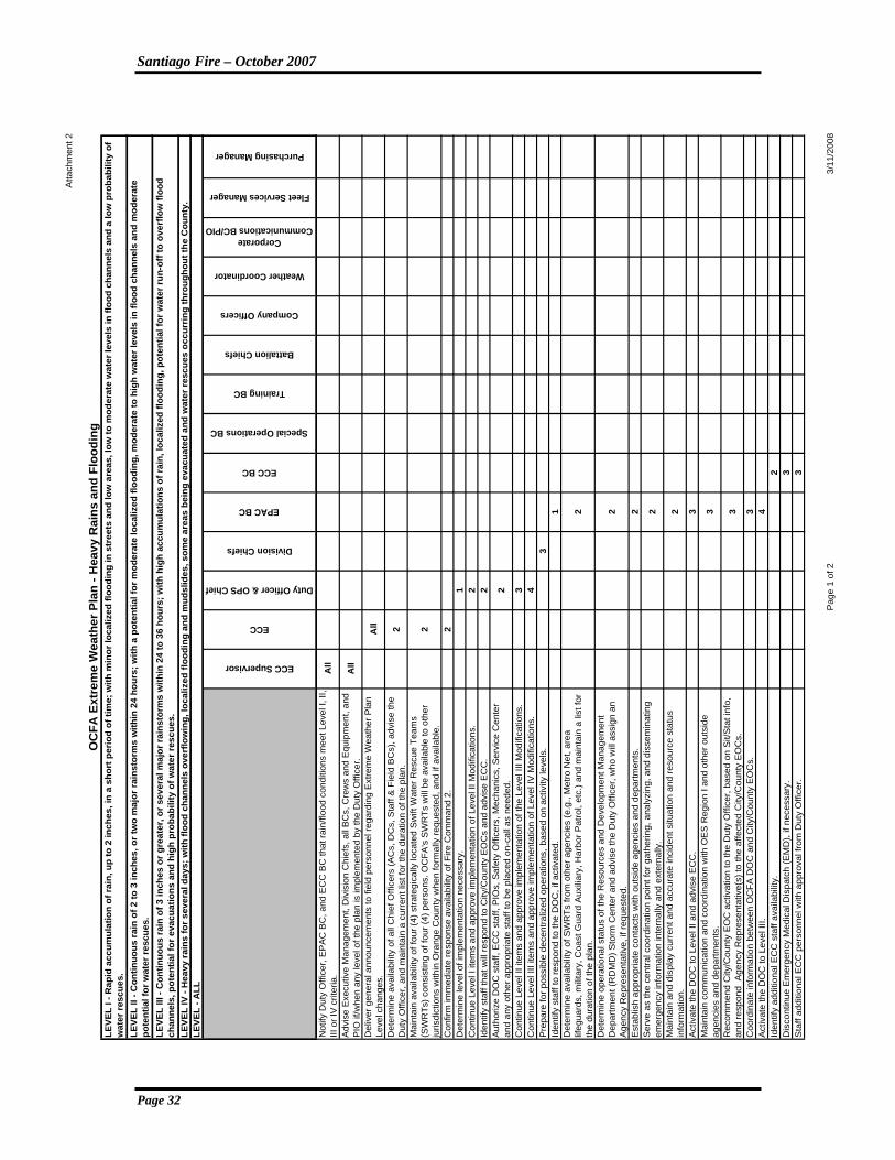
Santiago Fire – October 2007
Page 32
Atta
chm
ent 2
ECC Supervisor
ECC
Duty Officer & OPS Chief
Division Chiefs
EPAC BC
ECC BC
Special Operations BC
Training BC
Battalion Chiefs
Company Officers
Weather Coordinator
Corporate Communications BC/PIO
Fleet Services Manager
Purchasing Manager
Not
ify D
uty
Offi
cer,
EP
AC
BC
, and
EC
C B
C th
at ra
in/fl
ood
cond
ition
s m
eet L
evel
I, II
, III
or I
V c
riter
ia.
All
Adv
ise
Exe
cutiv
e M
anag
emen
t, D
ivis
ion
Chi
efs,
all
BC
s, C
rew
s an
d E
quip
men
t, an
d P
IO if
/whe
n an
y le
vel o
f the
pla
n is
impl
emen
ted
by th
e D
uty
Offi
cer.
All
Del
iver
gen
eral
ann
ounc
emen
ts to
fiel
d pe
rson
nel r
egar
ding
Ext
rem
e W
eath
er P
lan
Leve
l cha
nges
.A
ll
Det
erm
ine
avai
labi
lity
of a
ll C
hief
Offi
cers
(AC
s, D
Cs,
Sta
ff &
Fie
ld B
Cs)
, adv
ise
the
Dut
y O
ffice
r, an
d m
aint
ain
a cu
rren
t lis
t for
the
dura
tion
of th
e pl
an.
2
Mai
ntai
n av
aila
bilit
y of
four
(4) s
trate
gica
lly lo
cate
d S
wift
Wat
er R
escu
e Te
ams
(SW
RTs
) con
sist
ing
of fo
ur (4
) per
sons
. OC
FA's
SW
RTs
will
be
avai
labl
e to
oth
er
juris
dict
ions
with
in O
rang
e C
ount
y w
hen
form
ally
requ
este
d, a
nd if
ava
ilabl
e.
2
Con
firm
imm
edia
te re
spon
se a
vaila
bilit
y of
Fire
Com
man
d 2.
2D
eter
min
e le
vel o
f im
plem
enta
tion
nece
ssar
y.1
Con
tinue
Lev
el I
item
s an
d ap
prov
e im
plem
enta
tion
of L
evel
II M
odifi
catio
ns.
2Id
entif
y st
aff t
hat w
ill re
spon
d to
City
/Cou
nty
EO
Cs
and
advi
se E
CC
.2
Aut
horiz
e D
OC
sta
ff, E
CC
sta
ff, P
IOs,
Saf
ety
Offi
cers
, Mec
hani
cs, S
ervi
ce C
ente
r an
d an
y ot
her a
ppro
pria
te s
taff
to b
e pl
aced
on-
call
as n
eede
d.2
Con
tinue
Lev
el II
item
s an
d ap
prov
e im
plem
enta
tion
of th
e Le
vel I
II M
odifi
catio
ns.
3C
ontin
ue L
evel
III i
tem
s an
d ap
prov
e im
plem
enta
tion
of L
evel
IV M
odifi
catio
ns.
4P
repa
re fo
r pos
sibl
e de
cent
raliz
ed o
pera
tions
, bas
ed o
n ac
tivity
leve
ls.
3Id
entif
y st
aff t
o re
spon
d to
the
DO
C, i
f act
ivat
ed.
1D
eter
min
e av
aila
bilit
y of
SW
RTs
from
oth
er a
genc
ies
(e.g
., M
etro
Net
, are
a lif
egua
rds,
mili
tary
, Coa
st G
uard
Aux
iliar
y, H
arbo
r Pat
rol,
etc.
) and
mai
ntai
n a
list f
or
the
dura
tion
of th
e pl
an.
2
Det
erm
ine
oper
atio
nal s
tatu
s of
the
Res
ourc
es a
nd D
evel
opm
ent M
anag
emen
t D
epar
tmen
t (R
DM
D) S
torm
Cen
ter a
nd a
dvis
e th
e D
uty
Offi
cer,
who
will
ass
ign
an
Age
ncy
Rep
rese
ntat
ive,
if re
ques
ted.
2
Est
ablis
h ap
prop
riate
con
tact
s w
ith o
utsi
de a
genc
ies
and
depa
rtmen
ts.
2S
erve
as
the
cent
ral c
oord
inat
ion
poin
t for
gat
herin
g, a
naly
zing
, and
dis
sem
inat
ing
emer
genc
y in
form
atio
n in
tern
ally
and
ext
erna
lly.
2
Mai
ntai
n an
d di
spla
y cu
rren
t and
acc
urat
e in
cide
nt s
ituat
ion
and
reso
urce
sta
tus
info
rmat
ion.
2
Act
ivat
e th
e D
OC
to L
evel
II a
nd a
dvis
e E
CC
.3
Mai
ntai
n co
mm
unic
atio
n an
d co
ordi
natio
n w
ith O
ES
Reg
ion
I and
oth
er o
utsi
de
agen
cies
and
dep
artm
ents
.3
Rec
omm
end
City
/Cou
nty
EO
C a
ctiv
atio
n to
the
Dut
y O
ffice
r, ba
sed
on S
it/S
tat i
nfo,
an
d re
spon
d A
genc
y R
epre
sent
ativ
e(s)
to th
e af
fect
ed C
ity/C
ount
y E
OC
s.3
Coo
rdin
ate
info
rmat
ion
betw
een
OC
FA D
OC
and
City
/Cou
nty
EO
Cs.
3A
ctiv
ate
the
DO
C to
Lev
el II
I.4
Iden
tify
addi
tiona
l EC
C s
taff
avai
labi
lity.
2D
isco
ntin
ue E
mer
genc
y M
edic
al D
ispa
tch
(EM
D),
if ne
cess
ary.
3S
taff
addi
tiona
l EC
C p
erso
nnel
with
app
rova
l fro
m D
uty
Offi
cer.
3
OC
FA E
xtre
me
Wea
ther
Pla
n - H
eavy
Rai
ns a
nd F
lood
ing
LEVE
L - A
LL
LEVE
L I -
Rap
id a
ccum
ulat
ion
of ra
in, u
p to
2 in
ches
, in
a sh
ort p
erio
d of
tim
e; w
ith m
inor
loca
lized
floo
ding
in s
tree
ts a
nd lo
w a
reas
, low
to m
oder
ate
wat
er le
vels
in fl
ood
chan
nels
and
a lo
w p
roba
bilit
y of
w
ater
resc
ues.
LEVE
L II
- Con
tinuo
us ra
in o
f 2 to
3 in
ches
, or t
wo
maj
or ra
inst
orm
s w
ithin
24
hour
s; w
ith a
pot
entia
l for
mod
erat
e lo
caliz
ed fl
oodi
ng, m
oder
ate
to h
igh
wat
er le
vels
in fl
ood
chan
nels
and
mod
erat
e po
tent
ial f
or w
ater
resc
ues.
LEVE
L III
- C
ontin
uous
rain
of 3
inch
es o
r gre
ater
, or s
ever
al m
ajor
rain
stor
ms
with
in 2
4 to
36
hour
s; w
ith h
igh
accu
mul
atio
ns o
f rai
n, lo
caliz
ed fl
oodi
ng, p
oten
tial f
or w
ater
run-
off t
o ov
erflo
w fl
ood
chan
nels
, pot
entia
l for
eva
cuat
ions
and
hig
h pr
obab
ility
of w
ater
resc
ues.
LEVE
L IV
- H
eavy
rain
s fo
r sev
eral
day
s; w
ith fl
ood
chan
nels
ove
rflo
win
g, lo
caliz
ed fl
oodi
ng a
nd m
udsl
ides
, som
e ar
eas
bein
g ev
acua
ted
and
wat
er re
scue
s oc
curr
ing
thro
ugho
ut th
e C
ount
y.
Pag
e 1
of 2
3/11
/200
8

Santiago Fire – October 2007
Page 33
Atta
chm
ent 2
ECC Supervisor
ECC
Duty Officer & OPS Chief
Division Chiefs
EPAC BC
ECC BC
Special Operations BC
Training BC
Battalion Chiefs
Company Officers
Weather Coordinator
Corporate Communications BC/PIO
Fleet Services Manager
Purchasing Manager
OC
FA E
xtre
me
Wea
ther
Pla
n - H
eavy
Rai
ns a
nd F
lood
ing
LEV
EL
- ALL
LEV
EL
I - R
apid
acc
umul
atio
n of
rai
n, u
p to
2 in
ches
, in
a sh
ort p
erio
d of
tim
e; w
ith m
inor
loca
lized
floo
ding
in s
tree
ts a
nd lo
w a
reas
, low
to m
oder
ate
wat
er le
vels
in fl
ood
chan
nels
and
a lo
w p
roba
bilit
y of
w
ater
res
cues
.LE
VE
L II
- Con
tinuo
us r
ain
of 2
to 3
inch
es, o
r tw
o m
ajor
rai
nsto
rms
with
in 2
4 ho
urs;
with
a p
oten
tial f
or m
oder
ate
loca
lized
floo
ding
, mod
erat
e to
hig
h w
ater
leve
ls in
floo
d ch
anne
ls a
nd m
oder
ate
pote
ntia
l for
wat
er r
escu
es.
LEV
EL
III -
Con
tinuo
us r
ain
of 3
inch
es o
r gr
eate
r, o
r se
vera
l maj
or r
ains
torm
s w
ithin
24
to 3
6 ho
urs;
with
hig
h ac
cum
ulat
ions
of r
ain,
loca
lized
floo
ding
, pot
entia
l for
wat
er r
un-o
ff to
ove
rflo
w fl
ood
chan
nels
, pot
entia
l for
eva
cuat
ions
and
hig
h pr
obab
ility
of w
ater
res
cues
.LE
VE
L IV
- H
eavy
rai
ns fo
r se
vera
l day
s; w
ith fl
ood
chan
nels
ove
rflo
win
g, lo
caliz
ed fl
oodi
ng a
nd m
udsl
ides
, som
e ar
eas
bein
g ev
acua
ted
and
wat
er r
escu
es o
ccur
ring
thro
ugho
ut th
e C
ount
y.
Ens
ure
one
(1) O
CFA
hel
icop
ter i
s in
ser
vice
at F
ulle
rton
Airp
ort f
or re
scue
, re
con/
obse
rvat
ion/
airc
raft
coor
dina
tion,
sho
rt ha
ul re
scue
, or t
o tra
nspo
rt pe
rson
nel
and
equi
pmen
t. O
CFA
hel
icop
ters
SH
ALL
NO
T re
spon
d be
yond
the
loca
l O
pera
tiona
l Are
a.
2
Iden
tify
avai
labi
lity
of la
w e
nfor
cem
ent h
elic
opte
rs fo
r obs
erva
tion
and/
or re
scue
and
ad
vise
EC
C.
2
Sta
ff tw
o (2
) doz
ers
and
stra
tegi
cally
dep
loy.
Ens
ure
that
the
third
doz
er, o
r oth
er
heav
y eq
uipm
ent (
e.g.
gra
der,
dum
p tru
ck a
nd s
kip
load
er) a
re a
vaila
ble
but
unst
affe
d, a
nd p
rovi
de E
CC
with
con
tact
info
rmat
ion.
2
Che
ck a
vaila
bilit
y of
han
d cr
ew
2P
lace
two
(2) O
CFA
hel
icop
ters
in s
ervi
ce a
nd s
trate
gica
lly d
eplo
y.3
Hel
icop
ter F
uel T
ende
r and
sup
port
vehi
cles
sta
ffed
with
Res
erve
s an
d st
aged
with
he
licop
ters
.3
Det
erm
ine
avai
labi
lity
of o
pera
tors
for o
ther
hea
vy e
quip
men
t (e.
g. g
rade
r, du
mp
truck
and
ski
p lo
ader
) and
adv
ise
EC
C o
f con
tact
info
rmat
ion.
3
Det
erm
ine
avai
labi
lity
of R
eser
ve h
and
crew
s ba
sed
on c
rew
sup
ervi
sor a
vaila
bilit
y an
d ad
vise
EC
C o
f con
tact
info
rmat
ion.
3
Sta
ff ad
ditio
nal S
afet
y O
ffice
rs a
nd d
eplo
y as
dire
cted
by
the
Dut
y O
ffice
r, an
d ad
vise
EC
C.
3
Ens
ure
"Rel
ief V
ehic
le S
tatu
s" o
n th
e O
CFA
Intra
net i
s cu
rren
t for
all
units
and
co
nfirm
that
relie
f/res
erve
equ
ipm
ent i
s pr
epar
ed to
be
plac
ed in
ser
vice
.1
Rev
iew
loca
l con
tinge
ncy
plan
s an
d S
OP
s.1
Sta
ff/ha
rd-c
over
the
engi
ne a
t all
stan
d-al
one
Res
erve
sta
tions
(3, 1
1, 1
4, 1
6).
2E
valu
ate
the
need
to s
taff
the
four
(4) S
WR
Ts a
s st
and-
alon
e co
mpa
nies
and
bac
kfill
th
ose
units
with
app
rova
l fro
m D
uty
Offi
cer.
2
Sta
ff pa
trol/s
quad
uni
ts w
ith tw
o (2
) Res
erve
to p
atro
l pot
entia
l hig
h ris
k ar
eas
with
in
the
batta
lion.
3
Con
vert
pre-
desi
gnat
ed m
edic
eng
ines
to m
edic
van
s an
d hi
re b
ack
pers
onne
l to
staf
f as
regu
lar e
ngin
es w
ith th
ree
(3) p
erso
nnel
. (D
uty
Offi
cer
App
rova
l)4
Sta
ff al
l Typ
e III
eng
ines
with
car
eer p
erso
nnel
. (D
uty
Offi
cer
App
rova
l)4
Pro
vide
per
iodi
c up
date
s (S
it/S
tat r
epor
ts) t
o th
e D
OC
.3
Rev
iew
SO
P O
M 2
09.0
3, S
wift
Wat
er R
escu
e; S
OP
OM
203
.08,
San
d B
ags;
and
"In
fo S
and"
in C
AD
.1
Be
mor
e lib
eral
in in
terp
retin
g m
itiga
tion
actio
ns (b
efor
e fe
es a
re c
harg
ed) f
or w
ater
re
mov
al in
cide
nts
durin
g th
e st
orm
per
iod.
2
Pro
vide
per
iodi
c w
eath
er u
pdat
es to
Exe
cutiv
e M
anag
emen
t, D
uty
Offi
cer,
Div
isio
n C
hief
s, E
PA
C B
C, a
ll B
Cs,
EC
C, C
rew
s an
d E
quip
men
t, an
d P
IO.
1
Gat
her,
mon
itor a
nd d
isse
min
ate
NW
S in
form
atio
n an
d fie
ld w
eath
er d
ata
to
appr
opria
te lo
catio
ns/in
divi
dual
s.2
Iden
tify
avai
labi
lity
of P
IOs
for i
mm
edia
te re
spon
se to
med
ia c
ente
r and
to in
cide
nts,
an
d ad
vise
EC
C.
2
Det
erm
ine
avai
labi
lity
of S
ervi
ce C
ente
r sta
ff an
d ad
vise
EC
C o
f con
tact
info
rmat
ion.
2
Pag
e 2
of 2
3/11
/200
8

Santiago Fire – October 2007
Page 34
ORANGE COUNTY FIRE AUTHORITY Page 1 of 4 OM 209.12 STANDARD OPERATING PROCEDURES 1/16/06 REVISED TACTICAL PLANS RED FLAG ALERT/HAZARDOUS FIRE CONDITIONS PROGRAM INTENT The Red Flag Alert Program is designed to prevent large fires that may occur as a result of extreme or adverse weather conditions. The program is an intensive, cooperative, watch-and-warning fire prevention patrol, and public awareness program that is conducted by local, state, and federal fire services in conjunction with private cooperators during periods of extreme fire danger. Key goals of the program are:
• Public cooperation in preventing fires through mass media exposure and direct
personal contacts;
• Fire prevention through patrols in high risk areas;
• Early detection and reporting of fires and identification of suspicious circumstances; and
• Faster response to any fire.
Refer to MACS Procedure Guide 410-3. PROCEDURE Activation of the Red Flag Alert program is based upon on local weather and fuel conditions. When information from the U.S. Weather Service on current and predicted weather conditions, combined with information from fire service field sources indicate that the danger of fire is extreme, an alert will be initiated. This determination normally follows a basic formula used by all cooperating agencies. Criteria A Red Flag Fire Weather Watch or Red Flag Warning is issued by the National Fire Weather Service for any affected area where the wind speed is expected to be 25 M.P.H. or more and the humidity is expected to drop to 15 percent or less. A Red Flag Alert is issued when warning conditions exist plus a National Fire Danger Rating System Burning Index of 81 or greater. The Orange County Fire Authority may locally declare a “Hazardous Fire Condition” and take local actions when some of the Red Flag criteria exist and a formal Red Flag

Santiago Fire – October 2007
Page 35
declaration has not been issued. Depletion of suppression and prevention forces or other extraordinary circumstances are considered in the declaration decision. Program Stages Stage I Fire Weather WATCH - Usually 48 to 72 hours in advance. Stage II RED FLAG WARNING -Usually 24 hours in advance (agencies may notify
media). Stage III RED FLAG ALERT - (agencies will notify media).
Limited: Red Flag conditions exist or are occurring in somewhat isolated geographical areas of Southern California verified and implemented by the local officer in charge. General: Red Flag conditions exist or are occurring over a large portion of Southern California verified and implemented by the local officer in charge.
Stage IV CANCELLATION -Red Flag conditions no longer exist, verified and
canceled by agency officer in charge.
Alert Procedures Stage I and II (Watch & Warning) Stage I and II will be declared by the National Weather Service's fire weather forecast. The notice will be received in ECC. ECC will notify the Duty Officer and the Emergency Planning & Coordination Battalion Chief who will serve as the Red Flag Coordinator. Prediction of Red Flag conditions by the National Weather Service may cover a broad area. Extreme fire conditions may actually occur in one local area and not in another, therefore, the Duty Officer will direct the Red Flag Coordinator to take appropriate preparatory actions based on the local conditions and predicted forecasts. More detailed information on decision and response actions is maintained in the Orange County Fire Authority Red Flag Plan/Hazardous Fire Condition Handbook. Stage III (Alert) The Emergency Communications Center (ECC) will receive Red Flag notifications from the National Weather Service. ECC will immediately notify the Duty Officer and the Emergency Planning and Coordination Battalion Chief. The Duty Officer will assess the need to implement the Red Flag Alert Plan and, if appropriate, will direct the Red Flag Coordinator to institute the following Red Flag procedures: • Advise FIRESCOPE Operations Coordination Center (ECC, Riverside) and
Operational Nets of the declaration notice.

Santiago Fire – October 2007
Page 36
• Provide regularly updated weather information to the Duty Officer, on-duty Chief
Officers, Special Operations, Community Relations and Education, Operational Nets, and all Stations.
• Advise OCC, Riverside Situation Status Unit of manpower and equipment status on
ICS 405 Form (including resources from Operational Nets). • Implement Red Flag Patrols (per OCFA Red Flag Plan/Hazardous Fire Condition
Handbook). • Notify all stations. • Implement a Red Flag Information Plan to be developed and distributed to the
media and the public by the Community Relations and Education Section. • Request cooperating agencies and departments to implement previously agreed
upon plans. • Monitor all activities in the Region and Area and continually provide updated
information to the Duty Officer. • Direct ECC to notify by phone the following Agencies/Groups: Orange County
Sheriffs Department Communications/ Control One; • Emergency Planning Chief (EPAC) or designee will notify Greater Laguna Fire
Safe Council; Inter-canyon Fire Safe Council; County of Orange Radio Amateur Civil Emergency Service (OCRACES)
• Ensure timely and accurate information and updates are provided to the Duty
Officer, all Chief Officers, Special Operations, Community Relations and Education, Fire Prevention, all fire stations, Operational Nets, Participating and Cooperating Agencies, and Chairperson of the OCFA Board of Directors.
Stage IV (Cancellation) A Regional Red Flag Cancellation notice will be received in ECC from The National Weather Service and/or OCC Riverside. ECC will notify the Duty Officer and the Red Flag Coordinator. If Orange County Fire Authority wishes to issue to other FIRESCOPE participating agencies, a cancellation notice for Orange County, the Duty Officer will advise the Red Flag Coordinator who will ensure that OCC Riverside is advised. When the Duty Officer directs the Red Flag Coordinator to cancel the Alert, the Red Flag Coordinator will:

Santiago Fire – October 2007
Page 37
• Notify all Chief Officers, Special Operations, Fire Prevention, all fire stations,
Operational Nets/Participating Agencies, Cooperating Agencies, and Chairperson of the OCFA Board of Directors of the Red Flag Alert termination.
• Deactivate the Red Flag Alert Patrols and collect documentation records and
prepare any required reports. • Direct ECC notify by phone the following Agencies/Groups of the cancellation:
Orange County Sheriffs Department Communications/ Control One. • Emergency Planning Chief (EPAC) or designee will notify Greater Laguna Fire
Safe Council; Inter-canyon Fire Safe Council; County of Orange Radio Amateur Civil Emergency Service (OCRACES)
• Direct the Community Relations and Education Section to contact the media,
acknowledging their cooperation and advising them of the Red Flag Alert Cancellation termination.
• Direct the Community Relations and Education Section to issue summary reports to
the media on the success of the Red Flag Program based on documentation provided by the Red Flag Coordinator.

Santiago Fire – October 2007
Page 38
PAGE INTENTIONALLY LEFT BLANK

Santiago Fire – October 2007
Page 39
Incident Narrative On Sunday, October 21, 2007 at 5:55:08 p.m., the Orange County Fire Authority (OCFA) responded to a report of a vegetation fire in the area of Santiago Canyon Road at Silverado Canyon Road, south of Irvine Lake. OCFA’s initial dispatch to the incident was an augmented High Watershed Response, which included the following: • 10 Engines and 1 Truck Company • 3 Patrols • 2 Bulldozers • 3 Water Tenders • 1 Helicopter • 2 Handcrews • 1 Type III Wildland Strike Team (5 engines) • 1 Local area Battalion Chief • 1 Incident Management Team (7 Chief Officers) • 1 Safety Officer • 1 PIO • 1 Command Bus with staff • Total of approximately 115 personnel Because of the advance planning that OCFA had done in anticipation of a major wind event, this augmented response eliminated the time it would normally take to assemble and dispatch a Type III wildland engine Strike Team, Incident Management Team, and Command Bus. At the time of dispatch, OCFA’s Emergency Communications Center (ECC) also placed a request with CAL FIRE for a standard aircraft order (1 air attack, 2 air tankers. and 1 medium helicopter with a fly crew). This order was not filled, as it was determined to be too late to meet the night time flight cut-off restrictions. Before the fire started, weather conditions throughout Southern California had been severe for 24 hours, with category 1 hurricane force northeast (Santa Ana) winds and extremely low relative humidity. OCFA’s remote weather site in Fremont Canyon, located 5 miles north of the fire at 1800 feet elevation, recorded sustained northeast Santa Ana wind speeds between 45-55 mph, with gusts to 85 mph at the time the fire started. The temperature was 68 degrees, with 9% relative humidity. Burning conditions were very critical. (See Incident Narrative Attachment 1 - Fremont Canyon Weather Summary.) Two units arrived on-scene almost simultaneously, with ORC Patrol 21 arriving at 6:00:33 p.m., and ORC Engine 15 at 6:00:34 p.m. (one second later). Due to the nature of the fire start (arson) there were multiple points of origin. These units were responding from different directions of travel on Santiago Canyon Road which resulted in Engine 15 arriving at the southern point of origin, and Patrol 21 at the northern point of origin of the fire. Patrol 21 began immediate suppression action, while Engine 15

Santiago Fire – October 2007
Page 40
provided an initial report on conditions, of a 3 acre fire in moderate fuels, wind driven and moving upslope and placed an order for the 10 closest engine companies. Shortly after this initial report, P-21 was forced to abandon their efforts to control the part of the fire they had initially attacked. Approximately one minute later, the first Chief Officer (ORC Battalion 38) arrived on-scene and assumed command of the incident. ORC Battalion 38 confirmed the actual location to be Santiago Canyon Road, one mile south of the Haul Road, made a request to close Santiago Canyon Road from Chapman Avenue to Modjeska and named the incident the Santiago Fire. He also reported the fire was now 15-20 acres, with major potential.
Response time for first arriving unit was 5:25 As initial attack units continued to arrive on-scene, commanders placed immediate requests for additional resources that included: • 5 Type I Engine Strike Teams (25 engines) for structure protection • 3 Type III Wildland Engine Strike Team (15 engines) • 6 Handcrew Strike Teams (12 handcrews) • 3 Dozer Strike Teams (6 bulldozers) • Plus the 10 closest engines originally requested by the first unit on-scene Additional resource requests in the first 10 minutes totaled 50 engines, 12 hand crews and 6 bulldozers At 6:05 p.m. Division Chief Rich Witesman (ORC Division 4) arrived on-scene, and began to further assess the fire conditions and spread. By 6:30 p.m. the fire had grown to over 150 acres with a very rapid rate of spread and long range spotting (flying embers) occurring well in advance of the fire. As the fire spread in a southerly direction towards Portola Parkway in the City of Irvine, residential, business, commercial properties and new construction projects north of Portola Parkway were imminently threatened. ORC Division 4 assumed command of the incident at this time, and ORC Battalion 38 was reassigned to assume Branch 1 responsibilities. ORC Division 4 remained OCFA’s Incident Commander for the duration of the incident. After consulting with members of the Incident Management Team that had responded, the Incident Commander had the Plans Section Chief establish the initial incident control objectives, which included keeping the fire: • North of Portola Parkway • West of Santiago Canyon Road

Santiago Fire – October 2007
Page 41
• East of the 261 Toll Road • North of the communities of Portola Hills and Foothill Ranch in the City of Lake Forest.
It was apparent from the onset, that this would become a rapidly spreading and significant fire. Logistics and Planning Section personnel were sent to Irvine Regional Park to establish an incident command post and base to support incident operations, and additional staff was requested to assist these functions. The Plans Section for the incident immediately began reviewing what opportunities might be considered for addressing the perimeter spread of the fire. Commanders were very aware of the need to “close the back door” and do what they could to prevent the fire from burning southeast toward the Whiting Ranch area, and protecting the City of Lake Forest’s foothill communities of Portola Hills and Foothill Ranch. Despite resources being very limited, with almost all available engine companies dealing with protection of structures in the Northwood and Portola Springs areas of Irvine, two OCFA bulldozers and a Battalion Chief were tasked to begin constructing indirect line.
The fire spread 3 miles in less than 20 minutes, crossing the 241 Toll Road The initial plan was to construct a bulldozer line beginning at Hangman’s Tree on Santiago Canyon Road to Bolero Road, then south down a major ridgeline with the goal of tying into the eastern portion of the Foothill Ranch area. The tactical approach would include firing out from this location around the residential developments in Foothill Ranch/Portola Hills, and tie the fire into the 241 Toll Road. If successful this tactical objective would have contained the eastern flank of the fire. However, due to a lack of additional wildland type resources available to secure and hold this section of line and the difficulty that would be encountered firing around the two large residential developments, this part of the planned control objective was abandoned and not completed before the fire burned past the minimal line already constructed, and continued in an easterly direction towards the area of Santiago Canyon Road and Ridgeline Drive. Conditions were so extreme during this early stage of the incident, and the fire was spreading so rapidly towards structures, that the Operations Section Chief on the incident, provided global direction referred to as “commanders intent” to all units on the fire. This “commander’s intent” established the following three priorities for all units and personnel to focus on: 1. Life safety for residents and firefighters 2. Protection of threatened structures most immediately at risk 3. Seek opportunities to make direct attack on the fire Residents in the Northwood and Portola Springs neighborhoods in the City of Irvine were advised to remain in their homes (sheltered in place). There was some early confusion about evacuations in Portola Springs that resulted in firefighters advising residents of an apartment complex in Orchard Hills, and a residential development in

Santiago Fire – October 2007
Page 42
Portola Springs that the evacuation was mandatory. This was quickly corrected, but not before some residents did evacuate. A temporary “care and reception center” was established by the City of Irvine and the Red Cross at the Lakeview Senior Center (located in Irvine) for residents of these two neighborhoods who may have mistakenly evacuated, as well as some other residents who didn’t feel comfortable with the “shelter in place” direction they had been provided. 47 residents who evacuated did show up at the center, with most evacuees returning home within a matter of hours. The center stayed open through the night to assist and serve residents until very early Monday morning, after all residents had safely returned to their homes.
During the first 30 minutes the fire had spread to a commercial agricultural property near the intersection of Portola and Jeffrey Road. Barracks style housing structures for farm workers began to ignite during this initial run of the fire. These burning buildings as well as drums of unknown chemicals were exploding, and conditions were unsafe for fire resources. Approximately 1 hour into the fire, 3 single resource
engines formed into a task force were deployed into this area. They were able to save a number of remaining uninvolved structures, which were categorized as “outbuildings” with no life safety threats. By 8:00 p.m. the fire had grown to over 5,000 acres. High winds, rugged terrain and long range spotting continued to contribute to rapid fire spread along the 261 Toll Road, threatening the Tustin Ranch area, and adjacent communities of Lemon Heights, Cowan Heights and the City of Orange. Offensive tactical actions were taken to protect these communities and the upper Peters Canyon from the advancing wind driven fire storm. (See Incident Narrative Attachment 2 – Fire Progression Map @ 2 hours)
Fire had grown to 5,000 acres in approximately 2 hours, with winds still gusting to hurricane force A significant offensive action the first night was a major backfiring operation on Loma Ridge adjacent to the County’s Emergency Operations Center (EOC). This critical action kept the fire from moving toward homes in the City of Orange, and unincorporated areas of Cowan and Lemon Heights. If unsecured in this location, the fire would have rapidly entered these canyon and hillside neighborhoods that have a history of losing many structures during previous major fires (Paseo Grande Fire-1967 and Gypsum Fire-1982). Given that every available firefighting resource was already committed, this would have severely complicated the emergency and put hundreds of residents in these neighborhoods in harms way.

Santiago Fire – October 2007
Page 43
Firefighters initiated the backfire, anchoring it to the single lane road that provides access to the EOC. This essential facility remained fully staffed and operational during this time, and structure protection resources were posted outside to deflect the fire and protect the facility in the event it became necessary. Firefighters burned out brush and grass fuels ahead of the main fire, and moved quickly to cut off the main fire. With the backfire successfully completed, along with an aggressive stand that a large number of fire engines took along Jamboree Road when another part of the fire jumped the 261 Toll Road and burned down to their position, residential areas to the west of the fire were protected and the fire was contained on this flank for the time being. Overnight and into the early morning hours of Monday, October 22nd, the fire spread continued south and east along Portola Parkway, threatening portions of the City of Irvine (Northwood and Portola Springs), Lake Forest (Foothill Ranch and Portola Hills) and the Musick Adult Detention Facility, Some residents in these areas were voluntarily evacuated or temporarily sheltered in-place. The Orange County Sheriff’s Department (OCSD) felt it would be best to temporarily evacuate the inmates at the Musick Facility. Over 1,000 inmates were evacuated, to other facilities during the daytime on Monday, and returned to the Musick Facility Monday evening as the direct threat to the facility subsided and the air quality improved.
Fire suppression crews (engine companies) were employing “bump & run” tactics in residential neighborhoods, and doing their best to take advantage of defendable space to protect structures directly in the path of the fire. “Bump & run” is a term used when firefighters move quickly from house to house, and street to street to protect homes in the direct path of the fire, moving as the fire (threat) moves.
Extreme wind conditions continued to cause erratic and unpredictable fire behavior, and most available suppression resources were assigned to protect lives and property in the fire’s path. A Unified Incident Command was established consisting of the OCFA, Orange County Sheriff’s Department and CAL-FIRE (formerly California Department of Forestry and Fire Protection).

Santiago Fire – October 2007
Page 44
Due to the continued rapid spread of the fire, the initial control objectives had to be amended for the day plan for Monday. The new control objectives for Monday were: • Keep the fire north of Portola Parkway • Keep the fire south of Santiago Canyon Road • Keep the fire east of Newport Blvd. • Keep the fire west of Whiting Ranch
By 10:00 a.m. Monday morning, the fire had burned 15,000 acres (16 hours)
Despite requests for additional ground resources (Master Mutual Aid) and aircraft, the only fire suppression resources assigned to the Santiago Fire during the daytime on Monday were from OCFA and other Orange County Operational Area fire departments. This included 94 engine companies and approximately 500 personnel. Insufficient ground resources and a lack of air support resulted in limited direct suppression action being taken on the perimeter spread of the fire, as the majority of suppression resources were actively involved in structure protection in evacuated neighborhoods. At 6:30 a.m. Monday October 22nd OCFA Helicopter 241 (HC-241) arrived at the incident, followed at 8:30 a.m. by OCFA Helicopter 41 (H-41). OCFA’s helicopter start times were staggered to provide full daylight hour coverage and prevent both pilots from “timing out” early in the day (maximum 8 hours flight time per pilot). HC-241 was unable to fly over the fire area due to the extreme winds and landed at the incident helibase near Irvine Lake. OCFA’s second helicopter (HC-41) departed Fullerton Airport shortly after 8:00 a.m. and flew directly to the helibase and staged on the ground. At 10 a.m. on Monday HC-241 made a short recon flight of the fire. The wind conditions were so severe, pilots for both helicopters determined they could not maintain safe control of their respective aircraft due to the extreme winds and water drops were not possible, and they were grounded at the helibase (located near Irvine Lake). At 11:55 a.m. on Monday while the helicopters were still grounded at the incident helibase, a new fire start in Anaheim Hills was reported, approximately 7 flight miles, and 5 minutes from the Santiago Fire helibase. The decision was made to send HC-241 to this new fire, to assess conditions and determine if it would be safe to engage and drop water. HC-241 arrived over the new incident, the pilot assessed the flight conditions at this location and determined he could fly safely and drop water. After making six water drops in 20 minutes, which greatly assisted in keeping this new fire small, HC-241 departed the area leaving the remaining control efforts to ground units.

Santiago Fire – October 2007
Page 45
At approximately 12:00 p.m. while HC-241 was at the Anaheim Hills fire HC-41 departed the helibase to re-assess the conditions in the Foothill Ranch/Portola Hills area of the fire. Upon arrival over this area, the pilot determined that wind conditions had changed, and were more favorable (and safer) to begin dropping water in support of ground forces on the southwest portion of the fire and could be accomplished if a ground
fill operation was established versus using the snorkel to fill while aloft. HC-41 was soon joined by HC-241 when it returned from Anaheim Hills at approximately 12:15 p.m. Both helicopters continued to fly and drop water throughout the day, until forced to stop due to darkness.
OCFA Helicopters began to fly and drop water @ noon on Monday Both hel At approximately 1:30 p.m. on Monday, an Air Tactical Group Supervisor (ATGS) in a light fixed wing observation plane arrived over the fire and began to communicate with the Air Operations Branch Director (AOBD) on the ground at the fire. He was accompanied by a lead plane, sometimes called a “bird dog”. The purpose of the lead plane is to check the approach and departure path to be flown by the larger and heavier air tankers. This is a safety procedure that is designed to check the airspace for hazards and turbulence prior to the air tankers entering the drop zone. OCFA’s Air Operations Branch Director on the ground instructed the lead plane to check a portion of the fire perimeter in the Foothill Ranch/Portola Hills area in anticipation of placing air tankers here in support of ground crews. The lead plane reported that due to extreme winds, he was unable to hold a constant altitude and heading. Thus, the ATGS made the determination that it was not safe for fixed wing air tankers to fly the fire. Throughout the day on Monday, suppression crews directed their efforts to saving lives, and protecting homes and businesses in areas that were evacuated or being evacuated. The communities of Portola Hills and Foothill Ranch in the City of Lake Forest were among the most directly threatened. As a result of defensible space (community fuel modifications and property set-backs), along
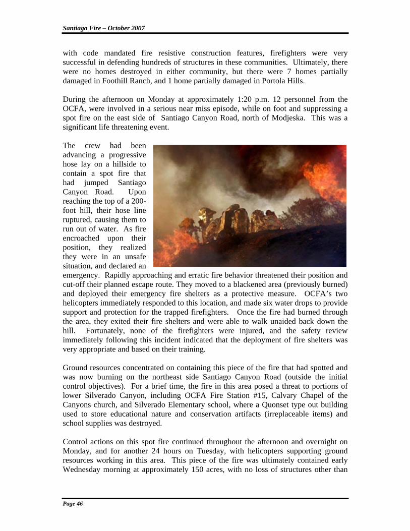
Santiago Fire – October 2007
Page 46
with code mandated fire resistive construction features, firefighters were very successful in defending hundreds of structures in these communities. Ultimately, there were no homes destroyed in either community, but there were 7 homes partially damaged in Foothill Ranch, and 1 home partially damaged in Portola Hills. During the afternoon on Monday at approximately 1:20 p.m. 12 personnel from the OCFA, were involved in a serious near miss episode, while on foot and suppressing a spot fire on the east side of Santiago Canyon Road, north of Modjeska. This was a significant life threatening event. The crew had been advancing a progressive hose lay on a hillside to contain a spot fire that had jumped Santiago Canyon Road. Upon reaching the top of a 200-foot hill, their hose line ruptured, causing them to run out of water. As fire encroached upon their position, they realized they were in an unsafe situation, and declared an emergency. Rapidly approaching and erratic fire behavior threatened their position and cut-off their planned escape route. They moved to a blackened area (previously burned) and deployed their emergency fire shelters as a protective measure. OCFA’s two helicopters immediately responded to this location, and made six water drops to provide support and protection for the trapped firefighters. Once the fire had burned through the area, they exited their fire shelters and were able to walk unaided back down the hill. Fortunately, none of the firefighters were injured, and the safety review immediately following this incident indicated that the deployment of fire shelters was very appropriate and based on their training. Ground resources concentrated on containing this piece of the fire that had spotted and was now burning on the northeast side Santiago Canyon Road (outside the initial control objectives). For a brief time, the fire in this area posed a threat to portions of lower Silverado Canyon, including OCFA Fire Station #15, Calvary Chapel of the Canyons church, and Silverado Elementary school, where a Quonset type out building used to store educational nature and conservation artifacts (irreplaceable items) and school supplies was destroyed. Control actions on this spot fire continued throughout the afternoon and overnight on Monday, and for another 24 hours on Tuesday, with helicopters supporting ground resources working in this area. This piece of the fire was ultimately contained early Wednesday morning at approximately 150 acres, with no loss of structures other than
Santiago Fire – October 2007
Page 47
the out building at the school. The aggressive actions to contain this section of line were very time consuming and necessitated assigning critical resources to ensure the fire didn’t progress into the community of Silverado Canyon where it would have become an immediate threat to numerous structures, most of which lack defendable space to safely protect them. Control actions and structure protection efforts on other portions of the fire progressed throughout the day, with engine company crews defending and saving hundreds of homes. However, a lack of resources, specifically aircraft, wildland engines, hand crews, and bulldozers continued to be problematic, as other crews took direct action to control the perimeter spread of the fire.
As of 6:00 p.m. on Monday, no out-of-area Mutual Aid engines had arrived, and the 90+ engines operating on the fire were from OCFA and other Orange County Operational Area fire departments
At sunset on Monday, October 22nd (approximately 6:00 p.m.) the Branch 1 Director (ORC Battalion 18) in the Foothill Ranch area reported a sudden and reverse wind shift that continued throughout the night. Despite strong north to northeast Santa Ana winds in excess of 40 mph being experienced elsewhere on the fire, and being recorded at the Fremont Weather Site (approximately 10 miles away), the wind in this particular area was reported as onshore (south to southwest) at approximately 18-20 mph. This was directly opposite the winds that were blowing less than one mile away near Modjeska Grade Road, which were estimated at 30-35 mph and even higher on other areas of the fire. (See Incident Narrative Attachment 3 – Fire Progression Map @ 24 hours) The highly unusual wind shift that was observed and recorded over this area of the fire on Monday night (October 22nd) is somewhat confusing, but easier to understand when the larger factors influencing the later stages of a Santa Ana wind event are considered. These factors are topographical, geographical and timing related, and combine for a phenomenon that is difficult to predict and even more difficult to react to safely in the wildland fire environment. Many experts consider this the most dangerous fire weather event that can occur, and one that often leads to even more erratic fire behavior than a true Santa Ana wind condition. It’s also been a contributing factor in firefighter entrapments and fatalities. Orange County is bordered on the east by the Santa Ana Mountains that lie roughly north and south. These mountains serve as both barriers and channels for wind. In Orange County, the Santa Ana winds begin blowing out of the north, transition from the northeast to the east, and as the high pressure area begins to break down and move south, the wind changes to a more southeasterly flow. Santa Ana winds are an air mass that moves like water through geographic barriers. Similar to water running down a stream, there are eddies and currents that bounce off these barriers and channel through valleys and canyons. Not unlike water, pressure differences create the speed component. The greater the pressure differences, the greater the speed.

Santiago Fire – October 2007
Page 48
As the Santiago Fire progressed, these components were in competition for dominance over the fire area. The pressure differences were beginning to equalize, and the overall pattern was attempting to return to the usual and prevailing on-shore (off of the ocean) winds that are common to Orange County, while the Santa Ana winds were still dominating the airflow aloft. This is not unlike when a stream begins to flatten out and there are calm areas, reverse currents, and some areas of swift directional flow. Early Monday evening, as the temperature cooled over the fire area, the air mass that had been pushing from the land to the ocean cooled over the water and began its reverse pattern from the ocean to the land. This air still had a very dry component to it, lacked the moisture recovery typically associated with an on-shore wind and was moving in the other direction (almost reverse of the Santa Ana winds) primarily in those drainages and canyon areas that were in alignment with the ocean. These unobstructed pathways in the Foothill Ranch, Portola Hills, and Modjeska Canyon areas are geographically situated in a manner that encouraged this air flow back over the fire, from the ocean to the land. Where this perfect alignment did not occur over the fire and where there were barriers to this reverse flow, the Santa Ana winds remained dominant and the wind continued to blow in a typical northeasterly Santa Ana wind direction. This is not uncommon but is a highly unpredictable and oftentimes sudden and dramatic event, with wind directions suddenly reversing back and forth over different areas of the fire based upon these unobstructed pathways and barriers. At approximately 8:10 p.m. Monday night (October 22nd), the first out-of-area Strike Team (5 engines) arrived at the Santiago Fire. This Strike Team was from Sutter County in northern California, and due to the distance traveled and fatigue, the crews had to be rested overnight prior to being assigned to the fire
The first out-of-area Mutual Aid Strike Team arrived 26 hours after the initial request During the night on Monday, fire behavior continued to be very extreme, with a rapid rate of spread. Erratic wind conditions (influenced by the changing wind direction) and dense fuels in the upper portion of Whiting Ranch Regional Park, near Santiago Canyon Road provided the key elements that drove the fire upslope and east. At approximately 12:30 a.m. on Tuesday, October 23rd, the fire spotted across Santiago Canyon Road in multiple locations near Santiago Canyon Road and Ridgeline Drive. The fire was now well established in another area beyond the original incident control objectives, and spreading rapidly towards the populated area of Modjeska Canyon. Fire behavior became so extreme as it crossed Santiago Canyon Road at this point, that the Operations Section Chief for the incident and the Branch Director in this area both determined that Santiago Canyon Road was unsafe for passage of vehicles. An immediate mandatory evacuation was ordered for Modjeska and Williams Canyons. The fire was also fast becoming a threat to Silverado Canyon at this point. Law enforcement personnel estimated it would take 4-6 hours to safely evacuate Silverado Canyon, thus fire commanders made the decision several hours later to begin mandatory evacuations in Silverado (approximately 5:00 a.m.).

Santiago Fire – October 2007
Page 49
This was a critical point in the spread of the fire, which had turned toward Modjeska Canyon
Once again, due to the rapid rate of spread and inability to establish permanent control lines, the incident control objectives had to be amended. The new control objectives for the Incident Action Plan (IAP) for Tuesday (October 23rd) were: • Keep the fire north of Portola Parkway • Keep the fire south of the Main Divide (separates Orange County from Riverside County) • Keep the fire east of Highway 261 & 241 Toll Roads to Sierra Peak • Keep the fire west of Trabuco Creek The sun rose on October 23rd (Tuesday) to a worsening situation in this area. The fire had crossed Santiago Canyon Road into rugged and heavily fueled terrain at a number of locations. With the sunrise came a more pronounced change in weather conditions. The Santa Ana winds were not as dominant as they had been in previous days, and the transition to on-shore winds (changing direction) was now pushing the fire east towards populated rural canyons. The fire began its run towards the Modjeska Canyon area in earnest around 8 a.m. on Tuesday morning. Now burning in alignment with the wind and steep slopes, the fire gained even greater intensity. Many of the same firefighting resources that had initially attacked the fire 36 hours earlier were still working tirelessly, as reinforcements from outside of Orange County had yet to arrive. Despite their exhaustion, they were now faced with aggressive fire behavior that threatened to burn the entire community of Modjeska Canyon.
Firefighters initially deployed to residences along Modjeska Grade Road. The fire hit this area hard and firefighters were overwhelmed as numerous homes and out buildings, many of them lacking defensible space were immediately threatened. Homes were beginning to ignite and burning conditions became so extreme that firefighters lives were threatened, requiring supervisors to order a tactical withdrawal to Santiago Canyon
Road to regroup. The high intensity fire was now poised to burn directly through numerous homes in Modjeska Canyon. The Operations Section Chief and two senior Chief Officers made their way back into Modjeska Canyon and developed a plan for firefighters to more safely make their way through the fire and redeploy in an attempt to protect structures. Using the Modjeska

Santiago Fire – October 2007
Page 50
Canyon Fire Plan (which had been developed in August, 2007) as a reference, these Chief Officers redeployed 25 engines into safer strategic locations where they could make a stand to defend the community. Despite fire exploding through heavy brush, propane tanks, and some outbuildings, firefighters aided by 4 fixed wing air tankers which were now assigned to the fire, fought through the day, deploying hose lines and backfiring around homes. Conditions were so severe at one point that an engine company protecting a home realized they were about to be over-run by fire. The company officer and firefighter took safe refuge inside the structure, while the engineer moved the apparatus out of harms way. The hose that the crew had deployed to protect this home was burned and unusable. As the fire passed, the crew emerged and did what they could to save the home, until given a direct order by their Strike Team Leader to abandon their efforts due to the unsafe conditions. The home was ultimately destroyed. An undetermined number of homes and out buildings were destroyed or damaged before and during the tactical withdrawal of resources for safety reasons. Following the redeployment of resources, additional structures were destroyed or damaged. In the Modjeska area (Modjeska Canyon, Modjeska Grade, Santiago Canyon and Gertner Ranch) 12 homes were destroyed, along with 11 out buildings. Most of the structures that were destroyed or damaged were in highly vulnerable locations. Factors contributing to the losses included steep slopes with heavy fuels located below them, location in tight box canyons and saddles, lack of defensible space and older non-fire resistive construction features. Beginning Tuesday morning, October 23rd, there were 4 fixed wing air tankers and 5 helicopters assigned to the incident. As air tankers attempted to support ground resources protecting structures in the Modjeska Canyon area, they also began laying a retardant line along the ridge top from Modjeska Canyon toward Williams Canyon. The intent was for this retardant line to cut-off further spread of the fire into Williams Canyon and ultimately Silverado Canyon. After consultation with the unified Incident Commanders from CAL FIRE and OCSD, the OCFA ordered an Incident Management Team, with the intent of supplementing current support and operational resources combating the fire.
Santiago Fire – October 2007
Page 51
An Incident Management Team (IMT) is a group of fire professionals trained in specific incident management positions as part of a standardized Incident Command system. IMTs are generally regarded as more experienced in managing large complex incidents requiring a higher level of logistical support, and are often requested to large scale disaster type situations to provide an enhanced level of incident management (i.e. Hurricane Katrina, earthquakes, major wildland fires in Southern California). Both CAL FIRE and the USFS have field IMTs, which are kept on rotational call year round. Federal teams such as the one that responded to the Santiago Fire are “typed” as to qualifications and experience, with Type 1 being the highest qualified and most experienced. Many OCFA personnel participate as members of state and federal Incident Management Teams and are pressed into service when their respective team is activated. The OCFA has sufficient trained, qualified and experienced personnel to manage large, complex local incidents. As part of the advance planning for the major wind event that occurred, OCFA had staffed a local IMT which was part of the initial response to the Santiago Fire. This local command team had done an outstanding job managing the fire from the start on Sunday, October 21st but, without rest they were fast becoming exhausted and the incident now required a much higher level of logistical support than could be sustained relying on local resources. As the incident progressed, it was decided by the unified Incident Commanders that an Incident Management Team (IMT) should be requested. An order for an IMT was placed, and Incident Commanders were advised this request would be filled by a federal Type 1 IMT. Reasons for this decision, included: • The protracted control time of the fire had created a major logistical challenge. • It was anticipated that the fire was going to soon be within a USFS direct protection area
(Cleveland National Forest) and would eventually become their responsibility for long term incident management.
• OCFA needed to maintain a strong focus on the structure threat to canyon communities. • Command level personnel that had managed the incident from the start had worked for 36+
hours, were becoming exhausted and needed relief. • Key OCFA personnel would remain as part of the command staff to provide assistance and
direction to the IMT regarding local policies and risk mitigation. • The incident would continue to be managed under the unified command that had been
established at the onset (OCFA, CAL FIRE, OCSD) and would now include the USFS.
During the mid-afternoon (approximately 2:30 p.m.) on Tuesday, the Santiago Incident Command Team conducted a transition briefing for the USFS Southwest Area Incident Management Team that had arrived, and incorporated them into the unified command that was managing the incident. The newly expanded unified Incident Management Team began planning in advance for the following day’s operational period, which would begin Wednesday morning.

Santiago Fire – October 2007
Page 52
Also during the early afternoon hours of Tuesday, the fire spread out of Modjeska Canyon, advancing in an easterly direction towards the Hamilton Truck Trail area, while also aggressively spreading to the south. Fire Officers met at Live Oak Canyon and Santiago Canyon Road to consider the new areas at risk, and were concerned as they watched a 1,000 foot fire whirl, a tornado of fire and smoke, form on the ridge directly north of the Cooks Corner road house bar. This fire whirl caused numerous spot fires to form in areas much closer to Trabuco Canyon, and the hundreds of rural homes located there. It was clear that immediate action would be required to hold the fire from these rural homes. Mandatory evacuations were ordered for the Trabuco Canyon area. Units were quickly assembled and a plan was created to start a backfire along Live Oak Canyon Road above Cooks Corner, and to usher this backfire above homes along Hamilton Truck Trail. Commanders knew this would be a difficult maneuver as the backfire had to be burned through the middle of heavy, century old brush, and burned around rural structures along the way. This required extreme caution, since any mistake could have resulted in the immediate loss of structures in this area and pushed the fire through Trabuco Canyon towards Rancho Santa Margarita. This complicated backfiring operation extended through the early evening hours on Tuesday and was visible from Mission Viejo, were residents could see the main fire and backfires dramatically burning into each other. By early morning on Wednesday (October 24th), the backfire had secured the Trabuco Canyon area and the fire was held to mountainous areas within the Cleveland National Forest. Later in the day, after aggressive air attack from helicopters and fixed wing air tankers, along with hard work by hand crews this portion of the fire was contained on the south to these mountain ridges. See Incident Narrative Attachment 4 – Fire Progression Map @ 48 hours)
During this same time period on Tuesday, engine company Strike Teams in the Foothill Ranch and Portola Hills areas were still actively involved in structure protection, and responding to smoke reports and flare-ups. However, the critical threat to these communities was beginning to subside.

Santiago Fire – October 2007
Page 53
The air tankers were unable to complete the retardant line between Modjeska and Williams Canyon they had started earlier in the day due to the night time cut-off for aircraft. There was a large gap remaining in this retardant line and there were no Type III engines, handcrews or bulldozers available to work this section and reinforce it. By 7:00 p.m. on Tuesday, October 23rd, 48 hours into the incident, the fire had burned 19,191 acres (67% of the total acreage ultimately burned) and was 30% contained. Thousands of residents had been evacuated or sheltered in place, and 12 homes had been destroyed in the Modjeska Canyon area. Evacuation centers were set-up in Lake Forest (El Toro High School) and the City of Orange (El Modena High School), with hundreds of residents evacuated (voluntary and mandatory).
The Emergency Operations Center (EOC) for the County had been activated at 6:52 p.m., less than one-hour after the fire started (October 21st), along with the near immediate activation of the EOC in the City of Irvine the same night, and followed by EOC activations in the cities of Lake Forest and Rancho Santa Margarita. The EOCs were actively engaged assisting with the coordination of evacuations,
evacuation centers, street and road closures, school closures, and coordination of local government resources and incident support activities. (Reference: Emergency Operations Center Section for additional information) As evacuations occurred in the canyon communities, residents of these affected communities began to congregate in the parking lot of the Albertsons shopping center at Jamboree and Chapman Avenue in the City of Orange. This came to be known as “Camp Silverado”. This is the closest commercial area to Silverado Canyon, and where many residents shop on a regular basis. (Reference: Volunteer Section for additional information) Evacuation of animals had been taking place since early in the fire, with many of these in canyon communities. Orange County Animal Care Services, with assistance from Orange County Sheriff Department Deputies, successfully sheltered in place approximately 150 animals. They impounded 212 animals and helped owners care for 30 animals at the El Modena High School evacuation center, and 156 animals at the El Toro High School evacuation center. They also assisted with the transportation of over 100 animals from various locations in canyon communities. Animals evacuated ranged from small animals (dogs, cats, chickens) to larger livestock (horses, goats, pigs, cows and llamas).

Santiago Fire – October 2007
Page 54
During the very early morning hours of Wednesday, fire that had spread out of Modjeska Canyon burned through the retardant line that the fixed wing air tankers had put in Tuesday afternoon, as well as the untreated gap and into upper Williams Canyon. Resources had been deployed into Williams Canyon in advance of this, but conditions became so severe they had to tactically withdraw. Crews did what they could to fire safety zones around homes, and treat them with protective foam as they were forced to withdraw, but 2 homes were destroyed. As the most serious fire threat passed and conditions improved, crews were redeployed into this area to resume structure protection and save the remaining homes. Shortly after the fire entered upper Williams Canyon, it began cresting the ridge on the south side of Silverado Canyon and dropping into several drainages off this ridge that feeds into Silverado. As the fire began to “drop down” into Silverado Canyon off this ridge, structure protection became an increasing concern. The fire was dropping down (creeping and spotting) into locations that resulted in it making an upslope run back towards the main fire. Commanders were very concerned that a spot fire would develop in the bottom of Silverado Canyon, or across to the south facing aspect and allow the fire to get established near structures in this community. By this time, subsequent out-of-area Strike Teams that had begun to arrive late Tuesday night (approximately 11 p.m.) were being immediately assigned to both of these critical areas of the fire. Some of these resources had been operating on the Canyon Fire in Los Angeles County all day, prior to being reassigned to the Santiago Fire. Crew fatigue for these arriving resources, as well as the other resources that had been operating on the fire for over 48 hours with minimal rest was becoming a safety factor and concern. At this point, the fire posed a major threat to the community of Silverado Canyon that has a population of approximately 1,300 residents, and 400 homes. The topography of this particular canyon community consists of steep canyon walls, surrounded by 100 year-old extremely flammable vegetation. This combination of topography and fuel makes it highly vulnerable to a wildland fire. A single two-lane winding road is the only means of ingress and egress to Silverado, and many of the homes and structures are older non-fire resistive, and lack defensible space. It is considered by fire professionals to be one of the most difficult communities in Orange County to protect when threatened by wildfire.
Under the direction of the unified Incident Commanders, the federal Type I IMT assumed management of the incident at 6:00 a.m. on Wednesday, October 24th.
At the time of transition to the Type I Incident Management Team on Wednesday morning, the fire had consumed 19,191 acres and was 50% contained. Structure loss and damage, included:
14 homes destroyed and 8 damaged 4 commercial structures destroyed and 3 damaged
24 out buildings destroyed and 3 damaged

Santiago Fire – October 2007
Page 55
Due to the spread of the fire, and the threat that now existed, efforts to protect the community were intensified even more beginning early Wednesday, October 24th and the mandatory evacuation that had been ordered early Tuesday morning (October 23rd) was reinforced to residents. Incident Commanders established a Silverado Structure Protection Group under the command of an OCFA Chief Officer who is a long-time resident of Silverado, with a great deal of local area knowledge about fire history and mudslide potential in this unique community. This Chief Officer was also intimately familiar with the pre-fire plan document (Silverado Fire Plan) that had been developed by the OCFA specifically for this area. In accordance with the Silverado Fire Plan, a staging area was established at the Calvary Chapel of the Canyons (local area church). This staging area was the location of daily line briefings for resources assigned directly to Silverado. Requiring units to stage each shift allowed the off-going resources to exit the canyon prior to additional units maneuvering into the area, thus limiting congestion problems. Unfortunately, this process caused concern with a couple of the residents who chose to ignore the mandatory evacuation order and remain in the area. There was a perception that resources were abandoning the canyon, when in fact they were traveling to the staging/briefing site. Information was provided to local area residents, and after the second day this was not an issue. Residents who refused to evacuate were permitted to leave their property and travel throughout the canyon. This seemed to result in incorrect information being passed along by a couple of individuals to evacuated residents at Camp Silverado (ad hoc evacuation center), requiring considerable time and effort to deal with to ensure evacuees were kept accurately informed of what was occurring. Crews assigned directly to this area were briefed on the historical significance of the community, fire history, hazard zones, escape routes, safe refuge areas, current fire conditions and the tactical plan to protect structures. Information from the Silverado Fire Plan was utilized during these briefings. The depth of the briefings resulted in the crews feeling ownership in the community and many made personal vows to not allow

Santiago Fire – October 2007
Page 56
structures to burn within the canyon. This ownership emerged in the detail placed in structure preparation efforts as well as personal attention to individual homes. As an example, one L.A. City Fire Department Engine Strike Team even went so far as to wash and put away dishes, clean the kitchen, mop the floors and empty the trash of a residence where the homeowner had invited the crews to make themselves at home. The homeowner was speechless and nearly in tears when she returned from being evacuated to a spotless house, that had suffered no damage. Other crews prepared an abandoned historical mining Assay Office with the same diligence given a million dollar home nearby. There are a number of additional anecdotal accounts of how crews assigned to structure protection in Silverado Canyon went far beyond just protecting homes. Tactically, areas of concern were identified in the Wildcat Canyon, Big Oak Canyon (aka Shrewsbury Springs) and Mine Tract areas. Engine Strike Teams were assigned throughout these areas with the direction to prepare structures, clear vegetation, create defensible space, improve safe refuge areas and remain in contact with the residents who refused to evacuate. The Type 1 Engine Strike Teams were limited in their effectiveness to clear vegetation due to a lack of needed equipment, such as chain saws which are not typically part of the standard equipment compliment for these structure type engines. Crews were able to sweep roofs, trim trees, remove combustibles from around structures, secure utilities, and apply fire retardant coatings such as Fire Gel. Strike Teams from the L.A. City Fire Department assigned in Silverado, carry Fire Gel on their apparatus and their personnel were well trained on its use and application techniques. Not only did they deplete the Fire Gel they carried, but on Thursday, October 25th the LAFD warehouse delivered additional Fire Gel overnight to re-supply these units. An additional 50 five gallon containers of Fire Gel was delivered by the Santiago Fire Logistics Section on October 26th and a total of 68 homes were treated with this fire resistive product. The Type III Wildland Engine Strike Teams were highly successful in clearing vegetation and along with the work of the handcrews removed over 22 tons of flammable material from around homes. This effort continued for several days, and each day fresh crews would improve upon what had been completed the day before. In the area of Wildcat Canyon a fuel break 200’ in depth was created around the historical Wildcat Ranch. In addition to the structure preparation efforts, a defensive firing plan was developed for the areas of the Wildcat Ranch and Mine Tract. Single increment engines were
Santiago Fire – October 2007
Page 57
assigned with other engines assigned to the Wildcat Ranch. A highly trained and specialized hotshot handcrew (Arrowhead Hotshots) from the Sequoia National Forest was identified as the firing team in the event this defensive plan had to be enacted. This contingency plan included line construction around the rear of homes to use as an anchor point to fire from in the event it became necessary. This was a very conservative plan to be implemented only as a last resort effort to save homes in the event the fire progressed into the bottom of Silverado Canyon, which would have made other tactics to protect structures virtually impossible. It required approximately two days constructing the fire line to support this contingency plan and prepare the community in the event this worst case scenario occurred. During this time the Operations Chief for the fire advised the Group Supervisor in charge in Silverado Canyon, that Incident Commanders and Planning Section staff were considering a plan to use Silverado Canyon Road as a control line, and to fire out the canyon from Oak Lane, east to the Maple Springs Gate in Mine Tract. Although this strategy and tactical approach sounded reasonable and appeared to be viable on the fire perimeter maps, it was considered by OCFA personnel with more local knowledge of Silverado Canyon to be a high risk operation, with a high degree of potential for fire spotting to the opposite side of the canyon and losing structures. The Silverado Structure Protection Group Supervisor and other key personnel expressed serious concerns about implementing this tactical approach, since it would involve the deliberate burning of critical watershed and hillside vegetation, thus exposing this very steep canyon to potentially serious debris flow, erosion and flood damage during the winter rainy season. The community of Silverado Canyon has a long fatal history of rock fall, debris flow, and flooding during non fire damaged years. Fire Chief Prather personally visited the area during this time, and made it clear to the command staff, that protection of Silverado Canyon from the fire was the highest priority, and that they were to make every effort to do this safely, while accomplishing it in such a manner as to take into consideration the need to preserve critical watershed and vegetation that would help the community withstand flood, erosion and debris flow issues afterwards. After significant dialog between operational commanders in the field and Incident Command staff, the decision was made to “go direct” and keep the fire from reaching the canyon bottom, versus firing it out. It was agreed that the firing plan that had been developed as a contingency would remain as a defensive last resort to save homes. This change in tactics required considerable resources, effort and time which lengthened the need for the mandatory evacuation of residents to
Santiago Fire – October 2007
Page 58
remain in effect. This direct attack approach was extremely difficult work for handcrews, under adverse conditions, and posed safety issues to personnel that had to be overcome. However, until all open fireline was secured on the ridge above the community of Silverado Canyon, it was not safe to allow residents to return to their home. As crews continued their efforts to create defensible space around individual homes, it quickly became apparent that the cut material was creating an equal hazard, was beginning to restrict egress to safety areas and would also restrict residents from returning home at some point. Brush that had been cleared by fire crews was piled roof high in many driveways and along roadways. The County of Orange Resources and Development Management Department (RDMD) provided compactor trucks and crews to remove the vegetation beginning Tuesday, October 30th and were further supported on November 1st by a contract chipper vendor. Engine Crews assisted in hauling vegetation from inaccessible narrow roads to Silverado Canyon Road for removal. As it became apparent that these tactics would be successful and that the fire would not progress into the canyon, the efforts of fire crews focused on yard cleaning, watering plants and preparing for residents to return to their homes. While structure protection actions were underway in Silverado Canyon substantial progress was being made on other areas of the fire, as more resources arrived and weather conditions continued to improve.
On Wednesday (October 24th), the strong Santa Ana winds continued to decrease, and the weather returned to a more seasonable pattern, with weak off-shore flow during the night and weak on-shore flow during the day over most of the fire area. Even though the winds and relative humidity had moderated greatly during this time, fire behavior continued to
be erratic, with extreme flame lengths and rapid rate of spread driven by topography and fuels. The on-shore wind influence in the afternoon periods helped to continue spreading the fire in an easterly direction. On this same day (October 24th) officials from the Riverside County Fire Department (CAL FIRE) and the City of Corona Fire Department met with the unified Incident Commanders to express concerns about the advance of the fire towards the Riverside County line and their respective jurisdictions. The unified Incident Commanders agreed

Santiago Fire – October 2007
Page 59
to incorporate a contingency plan that CAL FIRE-Riverside had developed for the areas of concern. This document and accompanying maps were distributed to operations personnel on the incident for consideration if the fire grew beyond the planned containment boundary identified in the incident control objectives. This included keeping the fire south of the Main Divide Truck Trail (a major ridgeline that separates Orange County from Riverside County that is within the boundary of the Cleveland National Forest). Several contingency lines (secondary) were constructed at the direction of the unified Incident Commanders to insure that contingency efforts could be exercised should the fire grow outside of the planned containment boundary. These efforts required a considerable commitment of air resources (fixed wing and helicopters) as well as handcrews and bulldozers. Fortunately, as a result of aggressive aviation and ground efforts, the fire remained within the containment boundary. Efforts continued to ensure that the 5 nationally significant communications sites near this ridgeline (Bolero Peak) remained protected. On October 28th, as weather conditions continued to moderate, crews were able to focus more attention on line construction in the Silverado Canyon area, cutting fireline from the Silverado Truck Trail to the east, in order to minimize the direct threat to homes in Silverado Canyon and minimize the long term effects that would be associated with the rainy season in this rock and mud slide prone area. On Friday, November 2nd, Fire Chief Prather organized a unified rehabilitation and restoration meeting with all the appropriate departments and agencies. It was agreed at this meeting, that all parties would work together to minimize the threats from future flood events to residents in burned areas, as well as downstream residents that might be affected by future storm events. (See Recovery Section for more information) On November 2nd and 3rd, Southern California experienced another major Santa Ana wind event. This event was weaker than the previous wind event, generating northeast to east winds of 15 to 25 mph, and gusts to 45 mph. However, this wind event contributed to extended periods of low relative humidity of 10% or less, and critically dangerous burning conditions were further exacerbated. Once again, OCFA staff planned ahead for this predicted wind event, and augmented staffing levels and pre-staged additional resources. A Red Flag Warning was issued for the southern California area for the period Saturday, November 3rd at 8:00 a.m. until 8:00 p.m., Sunday, November 4th. The OCFA did not experience any new fires during this less extreme wind event. During this time, winds caused the main body of the Santiago Fire to hold within its perimeter, which was now 90% contained. The remaining active fire was almost exclusively within the boundaries of the Cleveland National Forest (USFS jurisdiction). Control problems included “holding” a large unburned island on the south-eastern tip of the fire. Extensive handcrew and dozer work, augmented by air resources aided in

Santiago Fire – October 2007
Page 60
holding the fire within its main perimeter during this time, and there was minimal spread and no threats to structures. After 12 very long days, the mandatory evacuation order for Silverado Canyon was finally lifted on November 3rd, at approximately 4 p.m. and residents were permitted to return to their homes. No homes in Silverado Canyon were destroyed or damaged, and the only building lost was a Quonset type out building used to store nature and conservation artifacts and school supplies that was lost on the 2nd day of the fire (October 22nd). From November 3rd through November 9th, crews continued to reinforce fireline that had been constructed, extinguishing hot spots and fully securing the perimeter of the fire. The fire size only grew by several hundred acres during this time period, and work continued on the contingency line in the area of the Main Divide Truck Trail to ensure the fire stayed out of Riverside County. At one point this contingency planning included the possible use of a large one of a kind DC-10 (fixed wing aircraft) to drop long term retardant and reinforce this area of line in the event conditions changed. It never became necessary to employ this aircraft. On November 4th as the incident began to wind down and resources began to demobilize and be released, it was decided to transition incident management responsibilities to a Type II Incident Management Team (IMT). This is a common practice to transition to a smaller team. The incident remained under the unified command structure, with OCFA’s Special Operations Section Battalion Chief eventually replacing ORC Division 4 (Witesman) as OCFA’s Incident Commander on November 6th. (See Incident Narrative Attachment 5 - Fire Progression Map @ 14 days) The fire was declared fully under control on November 9th at 6:00 p.m. The unified incident command structure was disbanded, and overall incident management was turned over to the USFS (Cleveland National Forest). With aggressive recovery and rehabilitation efforts by local agencies already underway, OCFA resources continued to periodically patrol the fire for the next 10 days, checking for hot spots, responding to 9-1-1 calls reporting smoke in the burned area and ensuring that all line remained cold. The Santiago Fire burned for 19 days, ultimately burning 28,517 acres. A total of 42 structures were destroyed (14 homes, 4 commercial buildings and 24 out buildings). Another 14 structures (8 homes, 3 commercial buildings and 3 out buildings) were damaged. Additional damage included building contents, over 44 vehicles, mature avocado groves and expensive landscaping equipment and machinery. Many residents and businesses suffered smoke damaged property, lost wages and other economic impacts that are impossible to calculate. Estimated damage was $27.5 million. Fortunately, there were no fatalities or serious injuries to civilians or firefighters. At the peak of the fire, there were almost 2,000 fire personnel from 170 different agencies and 330 deputies and police officers from 5 local law enforcement agencies,

Santiago Fire – October 2007
Page 61
over 300 volunteers and more than 250 local, state, federal, private and non-profit entities involved, cooperating and providing assistance during the Santiago Fire. Together, this group of professionals and volunteers combined to successfully battle one of the largest, most devastating wildland fire disasters to ever strike Orange County.

Santiago Fire – October 2007
Page 62
Attachment 1
Fremont Canyon California
Daily Summary for October 21, 2007
Hour Wind Air Fuel Fuel Relative of Day Speed Temperature Temperature Moisture Humidity
Ave. Max. Mean Mean Mean Mean mph mph Deg. F. Deg. F. Percent Percent
1 am 31.0 39.0 65.0 63.0 9.5 22 2 am 37.0 48.0 65.0 65.0 8.7 16 3 am 40.0 60.0 66.0 63.0 8.2 12 4 am 33.0 65.0 64.0 62.0 7.8 10 5 am 43.0 68.0 65.0 62.0 7.5 10 6 am 48.0 66.0 64.0 63.0 7.3 10 7 am 47.0 75.0 62.0 61.0 7.2 10 8 am 50.0 71.0 65.0 64.0 7.0 9 9 am 46.0 79.0 65.0 69.0 6.8 8 10 am 50.0 74.0 68.0 68.0 6.7 8 11 am 47.0 83.0 69.0 71.0 6.5 8 12 pm 48.0 85.0 70.0 72.0 6.4 8 1 pm 53.0 74.0 69.0 70.0 6.3 8 2 pm 55.0 82.0 71.0 73.0 6.1 8 3 pm 48.0 84.0 70.0 73.0 6.1 7 4 pm 40.0 84.0 71.0 73.0 5.9 7 5 pm 51.0 73.0 70.0 70.0 5.8 7 6 pm 52.0 78.0 68.0 67.0 5.8 9 7 pm 50.0 85.0 66.0 66.0 5.7 9 8 pm 47.0 79.0 66.0 66.0 5.7 9 9 pm 54.0 70.0 66.0 66.0 5.7 9 10 pm 42.0 78.0 67.0 64.0 5.6 9 11 pm 47.0 74.0 65.0 65.0 5.7 10 12 am 43.0 75.0 67.0 64.0 5.6 9
Wind Air Fuel Fuel Relative Speed Temperature Temperature Moisture Humidity Ave. Max. Mean Mean Mean Mean mph mph Deg. F. Deg. F. Percent Percent
Ave. 45.9 66.8 66.7 6.6 10 Max. 85.0 71.0 73.0 9.5 22 Min. 62.0 61.0 5.6 7

Santiago Fire – October 2007
Page 63
Fremont Canyon California
MEAN WIND SPEED

Santiago Fire – October 2007
Page 64
MAXIMUM WIND GUST

Santiago Fire – October 2007
Page 65
Attachment 2
mile
s4
20
CLE
VELA
ND
CLE
VELA
ND
CLE
VELA
ND
CLE
VELA
ND
CLE
VELA
ND
CLE
VELA
ND
CLE
VELA
ND
CLE
VELA
ND
CLE
VELA
ND
NA
TIO
NA
LN
ATI
ON
AL
NA
TIO
NA
LN
ATI
ON
AL
NA
TIO
NA
LN
ATI
ON
AL
NA
TIO
NA
LN
ATI
ON
AL
NA
TIO
NA
LFO
RES
TFO
RES
TFO
RES
TFO
RES
TFO
RES
TFO
RES
TFO
RES
TFO
RES
TFO
RES
T
Irvin
eIrv
ine
Irvin
eIrv
ine
Irvin
eIrv
ine
Irvin
eIrv
ine
Irvin
eLa
keLa
keLa
keLa
keLa
keLa
keLa
keLa
keLa
ke
Sund
aySu
nday
Sund
aySu
nday
Sund
aySu
nday
Sund
aySu
nday
Sund
ay10
/21/
0710
/21/
0710
/21/
0710
/21/
0710
/21/
0710
/21/
0710
/21/
0710
/21/
0710
/21/
078:
00 P
M8:
00 P
M8:
00 P
M8:
00 P
M8:
00 P
M8:
00 P
M8:
00 P
M8:
00 P
M8:
00 P
M5,
000
acre
s5,
000
acre
s5,
000
acre
s5,
000
acre
s5,
000
acre
s5,
000
acre
s5,
000
acre
s5,
000
acre
s5,
000
acre
s
IRVI
NE
IRVI
NE
IRVI
NE
IRVI
NE
IRVI
NE
IRVI
NE
IRVI
NE
IRVI
NE
IRVI
NE
LAK
ELA
KE
LAK
ELA
KE
LAK
ELA
KE
LAK
ELA
KE
LAK
EFO
RES
TFO
RES
TFO
RES
TFO
RES
TFO
RES
TFO
RES
TFO
RES
TFO
RES
TFO
RES
TM
ISSI
ON
MIS
SIO
NM
ISSI
ON
MIS
SIO
NM
ISSI
ON
MIS
SIO
NM
ISSI
ON
MIS
SIO
NM
ISSI
ON
VIEJ
OVI
EJO
VIEJ
OVI
EJO
VIEJ
OVI
EJO
VIEJ
OVI
EJO
VIEJ
OR
AN
CH
OR
AN
CH
OR
AN
CH
OR
AN
CH
OR
AN
CH
OR
AN
CH
OR
AN
CH
OR
AN
CH
OR
AN
CH
OSA
NTA
SAN
TASA
NTA
SAN
TASA
NTA
SAN
TASA
NTA
SAN
TASA
NTA
MA
RG
AR
ITA
MA
RG
AR
ITA
MA
RG
AR
ITA
MA
RG
AR
ITA
MA
RG
AR
ITA
MA
RG
AR
ITA
MA
RG
AR
ITA
MA
RG
AR
ITA
MA
RG
AR
ITA
TUST
INTU
STIN
TUST
INTU
STIN
TUST
INTU
STIN
TUST
INTU
STIN
TUST
IN
OR
AN
GE
OR
AN
GE
OR
AN
GE
OR
AN
GE
OR
AN
GE
OR
AN
GE
OR
AN
GE
OR
AN
GE
OR
AN
GE
UN
INC
OR
POR
ATE
DU
NIN
CO
RPO
RA
TED
UN
INC
OR
POR
ATE
DU
NIN
CO
RPO
RA
TED
UN
INC
OR
POR
ATE
DU
NIN
CO
RPO
RA
TED
UN
INC
OR
POR
ATE
DU
NIN
CO
RPO
RA
TED
UN
INC
OR
POR
ATE
D
Will
iam
s C
anyo
nW
illia
ms
Can
yon
Will
iam
s C
anyo
nW
illia
ms
Can
yon
Will
iam
s C
anyo
nW
illia
ms
Can
yon
Will
iam
s C
anyo
nW
illia
ms
Can
yon
Will
iam
s C
anyo
n
Silv
erad
o C
anyo
n R
d.S
ilver
ado
Can
yon
Rd.
Silv
erad
o C
anyo
n R
d.S
ilver
ado
Can
yon
Rd.
Silv
erad
o C
anyo
n R
d.S
ilver
ado
Can
yon
Rd.
Silv
erad
o C
anyo
n R
d.S
ilver
ado
Can
yon
Rd.
Silv
erad
o C
anyo
n R
d.
Foot
hill
Foot
hill
Foot
hill
Foot
hill
Foot
hill
Foot
hill
Foot
hill
Foot
hill
Foot
hill
Ran
chR
anch
Ran
chR
anch
Ran
chR
anch
Ran
chR
anch
Ran
ch
Mod
jesk
a C
anyo
n R
d.M
odje
ska
Can
yon
Rd.
Mod
jesk
a C
anyo
n R
d.M
odje
ska
Can
yon
Rd.
Mod
jesk
a C
anyo
n R
d.M
odje
s ka
Can
yon
Rd.
Mod
jesk
a C
anyo
n R
d.M
odje
ska
Can
yon
Rd.
Mod
jesk
a C
anyo
n R
d.
Port
ola
Port
ola
Port
ola
Port
ola
Port
ola
Port
ola
Port
ola
Port
ola
Port
ola
Hil l
sH
il ls
Hil l
sH
il ls
Hil l
sH
il ls
Hil l
sH
il ls
Hil l
s
Santa Ana Frwy.
Santa Ana Frwy.
Santa Ana Frwy.
Santa Ana Frwy.
Santa Ana Frwy.
Santa Ana Frwy.
Santa Ana Frwy.
Santa Ana Frwy.
Santa Ana Frwy.
133 Toll Rd.
133 Toll Rd.
133 Toll Rd.
133 Toll Rd.
133 Toll Rd.
133 Toll Rd.
133 Toll Rd.
133 Toll Rd.
133 Toll Rd.
San
Dieg
o Fr
wy.
San
Dieg
o Fr
wy.
San
Dieg
o Fr
wy.
San
Dieg
o Fr
wy.
San
Dieg
o Fr
wy.
San
Dieg
o Fr
wy.
San
Dieg
o Fr
wy.
San
Dieg
o Fr
wy.
San
Dieg
o Fr
wy.
241
Toll R
d.
241
Toll R
d.
241
Toll R
d.
241
Toll R
d.
241
Toll R
d.
241
Toll R
d.
241
Toll R
d.
241
Toll R
d.
241
Toll R
d.
Irvine
Blvd
.
Irvine
Blvd
.
Irvine
Blvd
.
Irvine
Blvd
.
Irvine
Blvd
.
Irvine
Blvd
.
Irvine
Blvd
.
Irvine
Blvd
.
Irvine
Blvd
.
Sant
iago
Can
yon
Rd.
Sant
iago
Can
yon
Rd.
Sant
iago
Can
yon
Rd.
Sant
iago
Can
yon
Rd.
Sant
iago
Can
yon
Rd.
Sant
iago
Can
yon
Rd.
Sant
iago
Can
yon
Rd.
Sant
iago
Can
yon
Rd.
Sant
iago
Can
yon
Rd.
Hicks Canyon
Hicks Canyon
Hicks Canyon
Hicks Canyon
Hicks Canyon
Hicks Canyon
Hicks Canyon
Hicks Canyon
Hicks Canyon
Live Oak Canyon Rd.Live Oak Canyon Rd.Live Oak Canyon Rd.Live Oak Canyon Rd.Live Oak Canyon Rd.Live Oak Canyon Rd.Live Oak Canyon Rd.Live Oak Canyon Rd.Live Oak Canyon Rd.
El T
oro
Rd.
El T
oro
Rd.
El T
oro
Rd.
El T
oro
Rd.
El T
oro
Rd.
El T
oro
Rd.
El T
oro
Rd.
El T
oro
Rd.
El T
oro
Rd.
Porto
la Pk
wy.
Porto
la Pk
wy.
Porto
la Pk
wy.
Porto
la Pk
wy.
Porto
la Pk
wy.
Porto
la Pk
wy.
Porto
la Pk
wy.
Porto
la Pk
wy.
Porto
la Pk
wy.
Culver Dr.
Culver Dr.
Culver Dr.
Culver Dr.
Culver Dr.
Culver Dr.
Culver Dr.
Culver Dr.
Culver Dr.
261 Toll Rd.
261 Toll Rd.
261 Toll Rd.
261 Toll Rd.
261 Toll Rd.
261 Toll Rd.
261 Toll Rd.
261 Toll Rd.
261 Toll Rd.
Jamboree Rd.
Jamboree Rd.
Jamboree Rd.
Jamboree Rd.
Jamboree Rd.
Jamboree Rd.
Jamboree Rd.
Jamboree Rd.
Jamboree Rd.
NO
RTH
NO
RTH
NO
RTH
NO
RTH
NO
RTH
NO
RTH
NO
RTH
NO
RTH
NO
RTH
TUST
INTU
STIN
TUST
INTU
STIN
TUST
INTU
STIN
TUST
INTU
STIN
TUST
IN
RIV
E RS I
DE
CO
UN
T Y
El T
oro
Hig
h Sc
hool
El M
oden
a H
igh
Scho
ol
Poin
ts o
f Orig
in10
/21/
07 5
:55
PM
Sun
day
10-2
1 6:
25 p
mS
unda
y 10
-21
6:25
pm
Sun
day
10-2
1 6:
25 p
mS
unda
y 10
-21
6:25
pm
Sun
day
10-2
1 6:
25 p
mS
unda
y 10
-21
6:25
pm
Sun
day
10-2
1 6:
25 p
mS
unda
y 10
-21
6:25
pm
Sun
day
10-2
1 6:
25 p
m
Sant
iago
Fir
e Pe
rim
eter
Sund
ay 1
0/21
/07
@ 8
:00
PM5,
000
acre
s
Bar
rack
Sty
le H
ousi
ng B
urni
ng
Evac
uatio
n C
ente
rs
City
Bou
ndar
ies
Fire
Per
imet
er

Santiago Fire – October 2007
Page 66
Attachment 3
mile
s4
20
CLE
VELA
ND
CLE
VELA
ND
CLE
VELA
ND
CLE
VELA
ND
CLE
VELA
ND
CLE
VELA
ND
CLE
VELA
ND
CLE
VELA
ND
CLE
VELA
ND
NA
TIO
NA
LN
ATI
ON
AL
NA
TIO
NA
LN
ATI
ON
AL
NA
TIO
NA
LN
ATI
ON
AL
NA
TIO
NA
LN
ATI
ON
AL
NA
TIO
NA
LFO
RES
TFO
RES
TFO
RES
TFO
RES
TFO
RES
TFO
RES
TFO
RES
TFO
RES
TFO
RES
T
Irvin
eIrv
ine
Irvin
eIrv
ine
Irvin
eIrv
ine
Irvin
eIrv
ine
Irvin
eLa
keLa
keLa
keLa
keLa
keLa
keLa
keLa
keLa
ke
Mon
day
Mon
day
Mon
day
Mon
day
Mon
day
Mon
day
Mon
day
Mon
day
Mon
day
10/2
2/07
10/2
2/07
10/2
2/07
10/2
2/07
10/2
2/07
10/2
2/07
10/2
2/07
10/2
2/07
10/2
2/07
6:00
PM
6:00
PM
6:00
PM
6:00
PM
6:00
PM
6:00
PM
6:00
PM
6:00
PM
6:00
PM
est.
17,0
00 a
cres
est.
17,0
00 a
cres
est.
17,0
00 a
cres
est.
17,0
00 a
cres
est.
17,0
00 a
cres
est.
17,0
00 a
cres
est.
17,0
00 a
cres
est.
17,0
00 a
cres
est.
17,0
00 a
cres
Sund
aySu
nday
Sund
aySu
nday
Sund
aySu
nday
Sund
aySu
nday
Sund
ay10
/21/
0710
/21/
0710
/21/
0710
/21/
0710
/21/
0710
/21/
0710
/21/
0710
/21/
0710
/21/
078:
00 P
M8:
00 P
M8:
00 P
M8:
00 P
M8:
00 P
M8:
00 P
M8:
00 P
M8:
00 P
M8:
00 P
M5,
000
acre
s5,
000
acre
s5,
000
acre
s5,
000
acre
s5,
000
acre
s5,
000
acre
s5,
000
acre
s5,
000
acre
s5,
000
acre
s
IRVI
NE
IRVI
NE
IRVI
NE
IRVI
NE
IRVI
NE
IRVI
NE
IRVI
NE
IRVI
NE
IRVI
NE
LAK
ELA
KE
LAK
ELA
KE
LAK
ELA
KE
LAK
ELA
KE
LAK
EFO
RES
TFO
RES
TFO
RES
TFO
RES
TFO
RES
TFO
RES
TFO
RES
TFO
RES
TFO
RES
TM
ISSI
ON
MIS
SIO
NM
ISSI
ON
MIS
SIO
NM
ISSI
ON
MIS
SIO
NM
ISSI
ON
MIS
SIO
NM
ISSI
ON
VIEJ
OVI
EJO
VIEJ
OVI
EJO
VIEJ
OVI
EJO
VIEJ
OVI
EJO
VIEJ
OR
AN
CH
OR
AN
CH
OR
AN
CH
OR
AN
CH
OR
AN
CH
OR
AN
CH
OR
AN
CH
OR
AN
CH
OR
AN
CH
OSA
NTA
SAN
TASA
NTA
SAN
TASA
NTA
SAN
TASA
NTA
SAN
TASA
NTA
MA
RG
AR
ITA
MA
RG
AR
ITA
MA
RG
AR
ITA
MA
RG
AR
ITA
MA
RG
AR
ITA
MA
RG
AR
ITA
MA
RG
AR
ITA
MA
RG
AR
ITA
MA
RG
AR
ITA
TUST
INTU
STIN
TUST
INTU
STIN
TUST
INTU
STIN
TUST
INTU
STIN
TUST
IN
OR
AN
GE
OR
AN
GE
OR
AN
GE
OR
AN
GE
OR
AN
GE
OR
AN
GE
OR
AN
GE
OR
AN
GE
OR
AN
GE
UN
INC
OR
POR
ATE
DU
NIN
CO
RPO
RA
TED
UN
INC
OR
POR
ATE
DU
NIN
CO
RPO
RA
TED
UN
INC
OR
POR
ATE
DU
NIN
CO
RPO
RA
TED
UN
INC
OR
POR
ATE
DU
NIN
CO
RPO
RA
TED
UN
INC
OR
POR
ATE
D
Foot
hill
Foot
hill
Foot
hill
Foot
hill
Foot
hill
Foot
hill
Foot
hill
Foot
hill
Foot
hill
Ran
chR
anch
Ran
chR
anch
Ran
chR
anch
Ran
chR
anch
Ran
ch
Mod
jesk
a C
anyo
n R
d.M
odje
ska
Can
yon
Rd.
Mod
jesk
a C
anyo
n R
d.M
odje
ska
Can
yon
Rd.
Mod
jesk
a C
anyo
n R
d.M
odje
s ka
Can
yon
Rd.
Mod
jesk
a C
anyo
n R
d.M
odje
ska
Can
yon
Rd.
Mod
jesk
a C
anyo
n R
d.
Port
ola
Port
ola
Port
ola
Port
ola
Port
ola
Port
ola
Port
ola
Port
ola
Port
ola
Hil l
sH
il ls
Hil l
sH
il ls
Hil l
sH
il ls
Hil l
sH
il ls
Hil l
s
Will
iam
s C
anyo
nW
illia
ms
Can
yon
Will
iam
s C
anyo
nW
illia
ms
Can
yon
Will
iam
s C
anyo
nW
illia
ms
Can
yon
Will
iam
s C
anyo
nW
illia
ms
Can
yon
Will
iam
s C
anyo
n
Santa Ana Frwy.
Santa Ana Frwy.
Santa Ana Frwy.
Santa Ana Frwy.
Santa Ana Frwy.
Santa Ana Frwy.
Santa Ana Frwy.
Santa Ana Frwy.
Santa Ana Frwy.
133 Toll Rd.
133 Toll Rd.
133 Toll Rd.
133 Toll Rd.
133 Toll Rd.
133 Toll Rd.
133 Toll Rd.
133 Toll Rd.
133 Toll Rd.
San
Dieg
o Fr
wy.
San
Dieg
o Fr
wy.
San
Dieg
o Fr
wy.
San
Dieg
o Fr
wy.
San
Dieg
o Fr
wy.
San
Dieg
o Fr
wy.
San
Dieg
o Fr
wy.
San
Dieg
o Fr
wy.
San
Dieg
o Fr
wy.
241
Toll R
d.
241
Toll R
d.
241
Toll R
d.
241
Toll R
d.
241
Toll R
d.
241
Toll R
d.
241
Toll R
d.
241
Toll R
d.
241
Toll R
d.
Irvine
Blvd
.
Irvine
Blvd
.
Irvine
Blvd
.
Irvine
Blvd
.
Irvine
Blvd
.
Irvine
Blvd
.
Irvine
Blvd
.
Irvine
Blvd
.
Irvine
Blvd
.
Sant
iago
Can
yon
Rd.
Sant
iago
Can
yon
Rd.
Sant
iago
Can
yon
Rd.
Sant
iago
Can
yon
Rd.
Sant
iago
Can
yon
Rd.
Sant
iago
Can
yon
Rd.
Sant
iago
Can
yon
Rd.
Sant
iago
Can
yon
Rd.
Sant
iago
Can
yon
Rd.
Hicks Canyon
Hicks Canyon
Hicks Canyon
Hicks Canyon
Hicks Canyon
Hicks Canyon
Hicks Canyon
Hicks Canyon
Hicks Canyon
Silv
erad
o C
anyo
n R
d.S
ilver
ado
Can
yon
Rd.
Silv
erad
o C
anyo
n R
d.S
ilver
ado
Can
yon
Rd.
Silv
erad
o C
anyo
n R
d.S
ilver
ado
Can
yon
Rd.
Silv
erad
o C
anyo
n R
d.S
ilver
ado
Can
yon
Rd.
Silv
erad
o C
anyo
n R
d.
Live Oak Canyon Rd.Live Oak Canyon Rd.Live Oak Canyon Rd.Live Oak Canyon Rd.Live Oak Canyon Rd.Live Oak Canyon Rd.Live Oak Canyon Rd.Live Oak Canyon Rd.Live Oak Canyon Rd.
El T
oro
Rd.
El T
oro
Rd.
El T
oro
Rd.
El T
oro
Rd.
El T
oro
Rd.
El T
oro
Rd.
El T
oro
Rd.
El T
oro
Rd.
El T
oro
Rd.
Porto
la Pk
wy.
Porto
la Pk
wy.
Porto
la Pk
wy.
Porto
la Pk
wy.
Porto
la Pk
wy.
Porto
la Pk
wy.
Porto
la Pk
wy.
Porto
la Pk
wy.
Porto
la Pk
wy.
Culver Dr.
Culver Dr.
Culver Dr.
Culver Dr.
Culver Dr.
Culver Dr.
Culver Dr.
Culver Dr.
Culver Dr.
261 Toll Rd.
261 Toll Rd.
261 Toll Rd.
261 Toll Rd.
261 Toll Rd.
261 Toll Rd.
261 Toll Rd.
261 Toll Rd.
261 Toll Rd.
Jamboree Rd.
Jamboree Rd.
Jamboree Rd.
Jamboree Rd.
Jamboree Rd.
Jamboree Rd.
Jamboree Rd.
Jamboree Rd.
Jamboree Rd.
NO
RTH
NO
RTH
NO
RTH
NO
RTH
NO
RTH
NO
RTH
NO
RTH
NO
RTH
NO
RTH
TUST
INTU
STIN
TUST
INTU
STIN
TUST
INTU
STIN
TUST
INTU
STIN
TUST
IN
RIV
E RS I
DE
CO
UN
T Y
El T
oro
Hig
h Sc
hool
El M
oden
a H
igh
Scho
ol
Poin
ts o
f Orig
in10
/21/
07 5
:55
PM
Sun
day
10-2
1 6:
25 p
mS
unda
y 10
-21
6:25
pm
Sun
day
10-2
1 6:
25 p
mS
unda
y 10
-21
6:25
pm
Sun
day
10-2
1 6:
25 p
mS
unda
y 10
-21
6:25
pm
Sun
day
10-2
1 6:
25 p
mS
unda
y 10
-21
6:25
pm
Sun
day
10-2
1 6:
25 p
m
Sun
day
10-2
1 ap
prox
. 9:0
0 pm
Sun
day
10-2
1 ap
prox
. 9:0
0 pm
Sun
day
10-2
1 ap
prox
. 9:0
0 pm
Sun
day
10-2
1 ap
prox
. 9:0
0 pm
Sun
day
10-2
1 ap
prox
. 9:0
0 pm
Sun
day
10-2
1 ap
prox
. 9:0
0 pm
Sun
day
10-2
1 ap
prox
. 9:0
0 pm
Sun
day
10-2
1 ap
prox
. 9:0
0 pm
Sun
day
10-2
1 ap
prox
. 9:0
0 pm
Sant
iago
Fir
e Pe
rim
eter
Mon
day
10/2
2/07
@ 6
:00
PMes
t. 17
,000
acr
es
Bar
rack
Sty
le H
ousi
ng B
urni
ng
Lom
a R
idge
Bac
k Fi
re
Evac
uatio
n C
ente
rs
City
Bou
ndar
ies
Fire
Per
imet
er

Santiago Fire – October 2007
Page 67
Attachment 4
;; ; ; ; ; ; ;; ; ; ; ; ; ;; ; ; ; ; ; ;; ; ; ; ; ;; ; ; ; ; ; ;; ; ; ; ; ; ;; ; ; ; ; ; ;;
mile
s4
20
CLE
VELA
ND
CLE
VELA
ND
CLE
VELA
ND
CLE
VELA
ND
CLE
VELA
ND
CLE
VELA
ND
CLE
VELA
ND
CLE
VELA
ND
CLE
VELA
ND
NA
TIO
NA
LN
ATI
ON
AL
NA
TIO
NA
LN
ATI
ON
AL
NA
TIO
NA
LN
ATI
ON
AL
NA
TIO
NA
LN
ATI
ON
AL
NA
TIO
NA
LFO
RES
TFO
RES
TFO
RES
TFO
RES
TFO
RES
TFO
RES
TFO
RES
TFO
RES
TFO
RES
T
Irvin
eIrv
ine
Irvin
eIrv
ine
Irvin
eIrv
ine
Irvin
eIrv
ine
Irvin
eLa
keLa
keLa
keLa
keLa
keLa
keLa
keLa
keLa
ke
Tues
day
Tues
day
Tues
day
Tues
day
Tues
day
Tues
day
Tues
day
Tues
day
Tues
day
10/2
3/07
10/2
3/07
10/2
3/07
10/2
3/07
10/2
3/07
10/2
3/07
10/2
3/07
10/2
3/07
10/2
3/07
6:00
PM
6:00
PM
6:00
PM
6:00
PM
6:00
PM
6:00
PM
6:00
PM
6:00
PM
6:00
PM
est.
18,5
00 a
cres
est.
18,5
00 a
cres
est.
18,5
00 a
cres
est.
18,5
00 a
cres
est.
18,5
00 a
cres
est.
18,5
00 a
cres
est.
18,5
00 a
cres
est.
18,5
00 a
cres
est.
18,5
00 a
cres
Mon
day
Mon
day
Mon
day
Mon
day
Mon
day
Mon
day
Mon
day
Mon
day
Mon
day
10/2
2/07
10/2
2/07
10/2
2/07
10/2
2/07
10/2
2/07
10/2
2/07
10/2
2/07
10/2
2/07
10/2
2/07
6:00
PM
6:00
PM
6:00
PM
6:00
PM
6:00
PM
6:00
PM
6:00
PM
6:00
PM
6:00
PM
est.
17,0
00 a
cres
est.
17,0
00 a
cres
est.
17,0
00 a
cres
est.
17,0
00 a
cres
est.
17,0
00 a
cres
est.
17,0
00 a
cres
est.
17,0
00 a
cres
est.
17,0
00 a
cres
est.
17,0
00 a
cres
Sund
aySu
nday
Sund
aySu
nday
Sund
aySu
nday
Sund
aySu
nday
Sund
ay10
/21/
0710
/21/
0710
/21/
0710
/21/
0710
/21/
0710
/21/
0710
/21/
0710
/21/
0710
/21/
078:
00 P
M8:
00 P
M8:
00 P
M8:
00 P
M8:
00 P
M8:
00 P
M8:
00 P
M8:
00 P
M8:
00 P
M5,
000
acre
s5,
000
acre
s5,
000
acre
s5,
000
acre
s5,
000
acre
s5,
000
acre
s5,
000
acre
s5,
000
acre
s5,
000
acre
s
IRVI
NE
IRVI
NE
IRVI
NE
IRVI
NE
IRVI
NE
IRVI
NE
IRVI
NE
IRVI
NE
IRVI
NE
LAK
ELA
KE
LAK
ELA
KE
LAK
ELA
KE
LAK
ELA
KE
LAK
EFO
RES
TFO
RES
TFO
RES
TFO
RES
TFO
RES
TFO
RES
TFO
RES
TFO
RES
TFO
RES
TM
ISSI
ON
MIS
SIO
NM
ISSI
ON
MIS
SIO
NM
ISSI
ON
MIS
SIO
NM
ISSI
ON
MIS
SIO
NM
ISSI
ON
VIEJ
OVI
EJO
VIEJ
OVI
EJO
VIEJ
OVI
EJO
VIEJ
OVI
EJO
VIEJ
OR
AN
CH
OR
AN
CH
OR
AN
CH
OR
AN
CH
OR
AN
CH
OR
AN
CH
OR
AN
CH
OR
AN
CH
OR
AN
CH
OSA
NTA
SAN
TASA
NTA
SAN
TASA
NTA
SAN
TASA
NTA
SAN
TASA
NTA
MA
RG
AR
ITA
MA
RG
AR
ITA
MA
RG
AR
ITA
MA
RG
AR
ITA
MA
RG
AR
ITA
MA
RG
AR
ITA
MA
RG
AR
ITA
MA
RG
AR
ITA
MA
RG
AR
ITA
TUST
INTU
STIN
TUST
INTU
STIN
TUST
INTU
STIN
TUST
INTU
STIN
TUST
IN
OR
AN
GE
OR
AN
GE
OR
AN
GE
OR
AN
GE
OR
AN
GE
OR
AN
GE
OR
AN
GE
OR
AN
GE
OR
AN
GE
UN
INC
OR
POR
ATE
DU
NIN
CO
RPO
RA
TED
UN
INC
OR
POR
ATE
DU
NIN
CO
RPO
RA
TED
UN
INC
OR
POR
ATE
DU
NIN
CO
RPO
RA
TED
UN
INC
OR
POR
ATE
DU
NIN
CO
RPO
RA
TED
UN
INC
OR
POR
ATE
D
Foot
hill
Foot
hill
Foot
hill
Foot
hill
Foot
hill
Foot
hill
Foot
hill
Foot
hill
Foot
hill
Ran
chR
anch
Ran
chR
anch
Ran
chR
anch
Ran
chR
anch
Ran
ch
Mod
jesk
a C
anyo
n R
d.M
odje
ska
Can
yon
Rd.
Mod
jesk
a C
anyo
n R
d.M
odje
ska
Can
yon
Rd.
Mod
jesk
a C
anyo
n R
d.M
odje
s ka
Can
yon
Rd.
Mod
jesk
a C
anyo
n R
d.M
odje
ska
Can
yon
Rd.
Mod
jesk
a C
anyo
n R
d.
Port
ola
Port
ola
Port
ola
Port
ola
Port
ola
Port
ola
Port
ola
Port
ola
Port
ola
Hil l
sH
il ls
Hil l
sH
il ls
Hil l
sH
il ls
Hil l
sH
il ls
Hil l
s
Will
iam
s C
anyo
nW
illia
ms
Can
yon
Will
iam
s C
anyo
nW
illia
ms
Can
yon
Will
iam
s C
anyo
nW
illia
ms
Can
yon
Will
iam
s C
anyo
nW
illia
ms
Can
yon
Will
iam
s C
anyo
n
Santa Ana Frwy.
Santa Ana Frwy.
Santa Ana Frwy.
Santa Ana Frwy.
Santa Ana Frwy.
Santa Ana Frwy.
Santa Ana Frwy.
Santa Ana Frwy.
Santa Ana Frwy.
133 Toll Rd.
133 Toll Rd.
133 Toll Rd.
133 Toll Rd.
133 Toll Rd.
133 Toll Rd.
133 Toll Rd.
133 Toll Rd.
133 Toll Rd.
San
Dieg
o Fr
wy.
San
Dieg
o Fr
wy.
San
Dieg
o Fr
wy.
San
Dieg
o Fr
wy.
San
Dieg
o Fr
wy.
San
Dieg
o Fr
wy.
San
Dieg
o Fr
wy.
San
Dieg
o Fr
wy.
San
Dieg
o Fr
wy.
241
Toll R
d.
241
Toll R
d.
241
Toll R
d.
241
Toll R
d.
241
Toll R
d.
241
Toll R
d.
241
Toll R
d.
241
Toll R
d.
241
Toll R
d.
Irvine
Blvd
.
Irvine
Blvd
.
Irvine
Blvd
.
Irvine
Blvd
.
Irvine
Blvd
.
Irvine
Blvd
.
Irvine
Blvd
.
Irvine
Blvd
.
Irvine
Blvd
.
Sant
iago
Can
yon
Rd.
Sant
iago
Can
yon
Rd.
Sant
iago
Can
yon
Rd.
Sant
iago
Can
yon
Rd.
Sant
iago
Can
yon
Rd.
Sant
iago
Can
yon
Rd.
Sant
iago
Can
yon
Rd.
Sant
iago
Can
yon
Rd.
Sant
iago
Can
yon
Rd.
Hicks Canyon
Hicks Canyon
Hicks Canyon
Hicks Canyon
Hicks Canyon
Hicks Canyon
Hicks Canyon
Hicks Canyon
Hicks Canyon
Silv
erad
o C
anyo
n R
d.S
ilver
ado
Can
yon
Rd.
Silv
erad
o C
anyo
n R
d.S
ilver
ado
Can
yon
Rd.
Silv
erad
o C
anyo
n R
d.S
ilver
ado
Can
yon
Rd.
Silv
erad
o C
anyo
n R
d.S
ilver
ado
Can
yon
Rd.
Silv
erad
o C
anyo
n R
d.
Live Oak Canyon Rd.Live Oak Canyon Rd.Live Oak Canyon Rd.Live Oak Canyon Rd.Live Oak Canyon Rd.Live Oak Canyon Rd.Live Oak Canyon Rd.Live Oak Canyon Rd.Live Oak Canyon Rd.
El T
oro
Rd.
El T
oro
Rd.
El T
oro
Rd.
El T
oro
Rd.
El T
oro
Rd.
El T
oro
Rd.
El T
oro
Rd.
El T
oro
Rd.
El T
oro
Rd.
Porto
la Pk
wy.
Porto
la Pk
wy.
Porto
la Pk
wy.
Porto
la Pk
wy.
Porto
la Pk
wy.
Porto
la Pk
wy.
Porto
la Pk
wy.
Porto
la Pk
wy.
Porto
la Pk
wy.
Culver Dr.
Culver Dr.
Culver Dr.
Culver Dr.
Culver Dr.
Culver Dr.
Culver Dr.
Culver Dr.
Culver Dr.
261 Toll Rd.
261 Toll Rd.
261 Toll Rd.
261 Toll Rd.
261 Toll Rd.
261 Toll Rd.
261 Toll Rd.
261 Toll Rd.
261 Toll Rd.
Jamboree Rd.
Jamboree Rd.
Jamboree Rd.
Jamboree Rd.
Jamboree Rd.
Jamboree Rd.
Jamboree Rd.
Jamboree Rd.
Jamboree Rd.
NO
RTH
NO
RTH
NO
RTH
NO
RTH
NO
RTH
NO
RTH
NO
RTH
NO
RTH
NO
RTH
TUST
INTU
STIN
TUST
INTU
STIN
TUST
INTU
STIN
TUST
INTU
STIN
TUST
IN
RIV
E RS I
DE
CO
UN
T Y
El T
oro
Hig
h Sc
hool
El M
oden
a H
igh
Scho
ol
Poin
ts o
f Orig
in10
/21/
07 5
:55
PM
Sun
day
10-2
1 6:
25 p
mS
unda
y 10
-21
6:25
pm
Sun
day
10-2
1 6:
25 p
mS
unda
y 10
-21
6:25
pm
Sun
day
10-2
1 6:
25 p
mS
unda
y 10
-21
6:25
pm
Sun
day
10-2
1 6:
25 p
mS
unda
y 10
-21
6:25
pm
Sun
day
10-2
1 6:
25 p
m
Sun
day
10-2
1 ap
prox
. 9:0
0 pm
Sun
day
10-2
1 ap
prox
. 9:0
0 pm
Sun
day
10-2
1 ap
prox
. 9:0
0 pm
Sun
day
10-2
1 ap
prox
. 9:0
0 pm
Sun
day
10-2
1 ap
prox
. 9:0
0 pm
Sun
day
10-2
1 ap
prox
. 9:0
0 pm
Sun
day
10-2
1 ap
prox
. 9:0
0 pm
Sun
day
10-2
1 ap
prox
. 9:0
0 pm
Sun
day
10-2
1 ap
prox
. 9:0
0 pm
Wed
nesd
ay 1
0-24
Ear
ly a
mW
edne
sday
10-
24 E
arly
am
Wed
nesd
ay 1
0-24
Ear
ly a
mW
edne
sday
10-
24 E
arly
am
Wed
nesd
ay 1
0-24
Ear
ly a
mW
edne
sday
10-
24 E
arly
am
Wed
nesd
ay 1
0-24
Ear
ly a
mW
edne
sday
10-
24 E
arly
am
Wed
nesd
ay 1
0-24
Ear
ly a
m
Tues
day
10-2
3 ap
prox
. 8:0
0 am
Tues
day
10-2
3 ap
prox
. 8:0
0 am
Tues
day
10-2
3 ap
prox
. 8:0
0 am
Tues
day
10-2
3 ap
prox
. 8:0
0 am
Tues
day
10-2
3 ap
prox
. 8:0
0 am
Tues
day
10-2
3 ap
prox
. 8:0
0 am
Tues
day
10-2
3 ap
prox
. 8:0
0 am
Tues
day
10-2
3 ap
prox
. 8:0
0 am
Tues
day
10-2
3 ap
prox
. 8:0
0 am
Tues
day
10-2
3 00
:20
amTu
esda
y 10
-23
00:2
0 am
Tues
day
10-2
3 00
:20
amTu
esda
y 10
-23
00:2
0 am
Tues
day
10-2
3 00
:20
amTu
esda
y 10
-23
00:2
0 am
Tues
day
10-2
3 00
:20
amTu
esda
y 10
-23
00:2
0 am
Tues
day
10-2
3 00
:20
am
Mon
day
10-2
2 1:
20 p
mM
onda
y 10
-22
1:20
pm
Mon
day
10-2
2 1:
20 p
mM
onda
y 10
-22
1:20
pm
Mon
day
10-2
2 1:
20 p
mM
onda
y 10
-22
1:20
pm
Mon
day
10-2
2 1:
20 p
mM
onda
y 10
-22
1:20
pm
Mon
day
10-2
2 1:
20 p
m
Sant
iago
Fir
e Pe
rim
eter
Tue
sday
10/
23/0
7 @
6:0
0 PM
est.
18,5
00 a
cres
Bar
rack
Sty
le H
ousi
ng B
urni
ng
Lom
a R
idge
Bac
k Fi
re
Bur
nove
r
Spot
ting
Acr
oss S
antia
go
in
to M
odje
ska
Can
yon
Res
iden
ces B
urni
ng
Evac
uatio
n C
ente
rs
City
Bou
ndar
ies
Fire
Per
imet
er
;; ; ; ; ; ; ;; ; ; ; ; ; ;; ; ; ; ; ; ;; ; ; ; ; ;; ; ; ; ; ; ;; ; ; ; ; ; ;; ; ; ; ; ; ;;

Santiago Fire – October 2007
Page 68
Attachment 5
;; ; ; ; ; ; ;; ; ; ; ; ; ;; ; ; ; ; ; ;; ; ; ; ; ;; ; ; ; ; ; ;; ; ; ; ; ; ;; ; ; ; ; ; ;;
mile
s4
20
CLE
VELA
ND
CLE
VELA
ND
CLE
VELA
ND
CLE
VELA
ND
CLE
VELA
ND
CLE
VELA
ND
CLE
VELA
ND
CLE
VELA
ND
CLE
VELA
ND
NA
TIO
NA
LN
ATI
ON
AL
NA
TIO
NA
LN
ATI
ON
AL
NA
TIO
NA
LN
ATI
ON
AL
NA
TIO
NA
LN
ATI
ON
AL
NA
TIO
NA
LFO
RES
TFO
RES
TFO
RES
TFO
RES
TFO
RES
TFO
RES
TFO
RES
TFO
RES
TFO
RES
T
Irvin
eIrv
ine
Irvin
eIrv
ine
Irvin
eIrv
ine
Irvin
eIrv
ine
Irvin
eLa
keLa
keLa
keLa
keLa
keLa
keLa
keLa
keLa
ke
Tues
day
Tues
day
Tues
day
Tues
day
Tues
day
Tues
day
Tues
day
Tues
day
Tues
day
10/3
0/07
10/3
0/07
10/3
0/07
10/3
0/07
10/3
0/07
10/3
0/07
10/3
0/07
10/3
0/07
10/3
0/07
Mon
day
Mon
day
Mon
day
Mon
day
Mon
day
Mon
day
Mon
day
Mon
day
Mon
day
10/2
9/07
10/2
9/07
10/2
9/07
10/2
9/07
10/2
9/07
10/2
9/07
10/2
9/07
10/2
9/07
10/2
9/07 Su
nday
Sund
aySu
nday
Sund
aySu
nday
Sund
aySu
nday
Sund
aySu
nday
10/2
8/07
10/2
8/07
10/2
8/07
10/2
8/07
10/2
8/07
10/2
8/07
10/2
8/07
10/2
8/07
10/2
8/07
Satu
rday
Satu
rday
Satu
rday
Satu
rday
Satu
rday
Satu
rday
Satu
rday
Satu
rday
Satu
rday
10/2
7/07
10/2
7/07
10/2
7/07
10/2
7/07
10/2
7/07
10/2
7/07
10/2
7/07
10/2
7/07
10/2
7/07
Frid
ayFr
iday
Frid
ayFr
iday
Frid
ayFr
iday
Frid
ayFr
iday
Frid
ay10
/26/
0710
/26/
0710
/26/
0710
/26/
0710
/26/
0710
/26/
0710
/26/
0710
/26/
0710
/26/
07
Thur
sday
Thur
sday
Thur
sday
Thur
sday
Thur
sday
Thur
sday
Thur
sday
Thur
sday
Thur
sday
10/2
5/07
10/2
5/07
10/2
5/07
10/2
5/07
10/2
5/07
10/2
5/07
10/2
5/07
10/2
5/07
10/2
5/07
Wed
nesd
ayW
edne
sday
Wed
nesd
ayW
edne
sday
Wed
nesd
ayW
edne
sday
Wed
nesd
ayW
edne
sday
Wed
nesd
ay10
/24/
0710
/24/
0710
/24/
0710
/24/
0710
/24/
0710
/24/
0710
/24/
0710
/24/
0710
/24/
07
Tues
day
Tues
day
Tues
day
Tues
day
Tues
day
Tues
day
Tues
day
Tues
day
Tues
day
10/2
3/07
10/2
3/07
10/2
3/07
10/2
3/07
10/2
3/07
10/2
3/07
10/2
3/07
10/2
3/07
10/2
3/07
6:00
PM
6:00
PM
6:00
PM
6:00
PM
6:00
PM
6:00
PM
6:00
PM
6:00
PM
6:00
PM
est.
18,5
00 a
cres
est.
18,5
00 a
cres
est.
18,5
00 a
cres
est.
18,5
00 a
cres
est.
18,5
00 a
cres
est.
18,5
00 a
cres
est.
18,5
00 a
cres
est.
18,5
00 a
cres
est.
18,5
00 a
cres
Mon
day
Mon
day
Mon
day
Mon
day
Mon
day
Mon
day
Mon
day
Mon
day
Mon
day
10/2
2/07
10/2
2/07
10/2
2/07
10/2
2/07
10/2
2/07
10/2
2/07
10/2
2/07
10/2
2/07
10/2
2/07
6:00
PM
6:00
PM
6:00
PM
6:00
PM
6:00
PM
6:00
PM
6:00
PM
6:00
PM
6:00
PM
est.
17,0
00 a
cres
est.
17,0
00 a
cres
est.
17,0
00 a
cres
est.
17,0
00 a
cres
est.
17,0
00 a
cres
est.
17,0
00 a
cres
est.
17,0
00 a
cres
est.
17,0
00 a
cres
est.
17,0
00 a
cres
Sund
aySu
nday
Sund
aySu
nday
Sund
aySu
nday
Sund
aySu
nday
Sund
ay10
/21/
0710
/21/
0710
/21/
0710
/21/
0710
/21/
0710
/21/
0710
/21/
0710
/21/
0710
/21/
078:
00 P
M8:
00 P
M8:
00 P
M8:
00 P
M8:
00 P
M8:
00 P
M8:
00 P
M8:
00 P
M8:
00 P
M5,
000
acre
s5,
000
acre
s5,
000
acre
s5,
000
acre
s5,
000
acre
s5,
000
acre
s5,
000
acre
s5,
000
acre
s5,
000
acre
s
IRVI
NE
IRVI
NE
IRVI
NE
IRVI
NE
IRVI
NE
IRVI
NE
IRVI
NE
IRVI
NE
IRVI
NE
LAK
ELA
KE
LAK
ELA
KE
LAK
ELA
KE
LAK
ELA
KE
LAK
EFO
RES
TFO
RES
TFO
RES
TFO
RES
TFO
RES
TFO
RES
TFO
RES
TFO
RES
TFO
RES
TM
ISSI
ON
MIS
SIO
NM
ISSI
ON
MIS
SIO
NM
ISSI
ON
MIS
SIO
NM
ISSI
ON
MIS
SIO
NM
ISSI
ON
VIEJ
OVI
EJO
VIEJ
OVI
EJO
VIEJ
OVI
EJO
VIEJ
OVI
EJO
VIEJ
OR
AN
CH
OR
AN
CH
OR
AN
CH
OR
AN
CH
OR
AN
CH
OR
AN
CH
OR
AN
CH
OR
AN
CH
OR
AN
CH
OSA
NTA
SAN
TASA
NTA
SAN
TASA
NTA
SAN
TASA
NTA
SAN
TASA
NTA
MA
RG
AR
ITA
MA
RG
AR
ITA
MA
RG
AR
ITA
MA
RG
AR
ITA
MA
RG
AR
ITA
MA
RG
AR
ITA
MA
RG
AR
ITA
MA
RG
AR
ITA
MA
RG
AR
ITA
TUST
INTU
STIN
TUST
INTU
STIN
TUST
INTU
STIN
TUST
INTU
STIN
TUST
IN
OR
AN
GE
OR
AN
GE
OR
AN
GE
OR
AN
GE
OR
AN
GE
OR
AN
GE
OR
AN
GE
OR
AN
GE
OR
AN
GE
UN
INC
OR
POR
ATE
DU
NIN
CO
RPO
RA
TED
UN
INC
OR
POR
ATE
DU
NIN
CO
RPO
RA
TED
UN
INC
OR
POR
ATE
DU
NIN
CO
RPO
RA
TED
UN
INC
OR
POR
ATE
DU
NIN
CO
RPO
RA
TED
UN
INC
OR
POR
ATE
D
Frid
ayFr
iday
Frid
ayFr
iday
Frid
ayFr
iday
Frid
ayFr
iday
Frid
ay11
/2/0
711
/2/0
711
/2/0
711
/2/0
711
/2/0
711
/2/0
711
/2/0
711
/2/0
711
/2/0
7
Will
iam
s C
anyo
nW
illia
ms
Can
yon
Will
iam
s C
anyo
nW
illia
ms
Can
yon
Will
iam
s C
anyo
nW
illia
ms
Can
yon
Will
iam
s C
anyo
nW
illia
ms
Can
yon
Will
iam
s C
anyo
n
Silv
erad
o C
anyo
n R
d.S
ilver
ado
Can
yon
Rd.
Silv
erad
o C
anyo
n R
d.S
ilver
ado
Can
yon
Rd.
Silv
erad
o C
anyo
n R
d.S
ilver
ado
Can
yon
Rd.
Silv
erad
o C
anyo
n R
d.S
ilver
ado
Can
yon
Rd.
Silv
erad
o C
anyo
n R
d.
Port
ola
Port
ola
Port
ola
Port
ola
Port
ola
Port
ola
Port
ola
Port
ola
Port
ola
Hil l
sH
il ls
Hil l
sH
il ls
Hil l
sH
il ls
Hil l
sH
il ls
Hil l
s
Live Oak Canyon Rd.Live Oak Canyon Rd.Live Oak Canyon Rd.Live Oak Canyon Rd.Live Oak Canyon Rd.Live Oak Canyon Rd.Live Oak Canyon Rd.Live Oak Canyon Rd.Live Oak Canyon Rd.
Foot
hill
Foot
hill
Foot
hill
Foot
hill
Foot
hill
Foot
hill
Foot
hill
Foot
hill
Foot
hill
Ran
chR
anch
Ran
chR
anch
Ran
chR
anch
Ran
chR
anch
Ran
ch
Mod
jesk
a C
anyo
n R
d.M
odje
ska
Can
yon
Rd.
Mod
jesk
a C
anyo
n R
d.M
odje
ska
Can
yon
Rd.
Mod
jesk
a C
anyo
n R
d.M
odje
s ka
Can
yon
Rd.
Mod
jesk
a C
anyo
n R
d.M
odje
ska
Can
yon
Rd.
Mod
jesk
a C
anyo
n R
d.
Santa Ana Frwy.
Santa Ana Frwy.
Santa Ana Frwy.
Santa Ana Frwy.
Santa Ana Frwy.
Santa Ana Frwy.
Santa Ana Frwy.
Santa Ana Frwy.
Santa Ana Frwy.
133 Toll Rd.
133 Toll Rd.
133 Toll Rd.
133 Toll Rd.
133 Toll Rd.
133 Toll Rd.
133 Toll Rd.
133 Toll Rd.
133 Toll Rd.
San
Dieg
o Fr
wy.
San
Dieg
o Fr
wy.
San
Dieg
o Fr
wy.
San
Dieg
o Fr
wy.
San
Dieg
o Fr
wy.
San
Dieg
o Fr
wy.
San
Dieg
o Fr
wy.
San
Dieg
o Fr
wy.
San
Dieg
o Fr
wy.
241
Toll R
d.
241
Toll R
d.
241
Toll R
d.
241
Toll R
d.
241
Toll R
d.
241
Toll R
d.
241
Toll R
d.
241
Toll R
d.
241
Toll R
d.
Irvine
Blvd
.
Irvine
Blvd
.
Irvine
Blvd
.
Irvine
Blvd
.
Irvine
Blvd
.
Irvine
Blvd
.
Irvine
Blvd
.
Irvine
Blvd
.
Irvine
Blvd
.
Sant
iago
Can
yon
Rd.
Sant
iago
Can
yon
Rd.
Sant
iago
Can
yon
Rd.
Sant
iago
Can
yon
Rd.
Sant
iago
Can
yon
Rd.
Sant
iago
Can
yon
Rd.
Sant
iago
Can
yon
Rd.
Sant
iago
Can
yon
Rd.
Sant
iago
Can
yon
Rd.
Hicks Canyon
Hicks Canyon
Hicks Canyon
Hicks Canyon
Hicks Canyon
Hicks Canyon
Hicks Canyon
Hicks Canyon
Hicks Canyon
El T
oro
Rd.
El T
oro
Rd.
El T
oro
Rd.
El T
oro
Rd.
El T
oro
Rd.
El T
oro
Rd.
El T
oro
Rd.
El T
oro
Rd.
El T
oro
Rd.
Porto
la Pk
wy.
Porto
la Pk
wy.
Porto
la Pk
wy.
Porto
la Pk
wy.
Porto
la Pk
wy.
Porto
la Pk
wy.
Porto
la Pk
wy.
Porto
la Pk
wy.
Porto
la Pk
wy.
Culver Dr.
Culver Dr.
Culver Dr.
Culver Dr.
Culver Dr.
Culver Dr.
Culver Dr.
Culver Dr.
Culver Dr.
261 Toll Rd.
261 Toll Rd.
261 Toll Rd.
261 Toll Rd.
261 Toll Rd.
261 Toll Rd.
261 Toll Rd.
261 Toll Rd.
261 Toll Rd.
Jamboree Rd.
Jamboree Rd.
Jamboree Rd.
Jamboree Rd.
Jamboree Rd.
Jamboree Rd.
Jamboree Rd.
Jamboree Rd.
Jamboree Rd.
NO
RTH
NO
RTH
NO
RTH
NO
RTH
NO
RTH
NO
RTH
NO
RTH
NO
RTH
NO
RTH
TUST
INTU
STIN
TUST
INTU
STIN
TUST
INTU
STIN
TUST
INTU
STIN
TUST
IN
RIV
E RS I
DE
CO
UN
T Y
El T
oro
Hig
h Sc
hool
El M
oden
a H
igh
Scho
ol
Poin
ts o
f Orig
in10
/21/
07 5
:55
PM
Sun
day
10-2
1 6:
25 p
mS
unda
y 10
-21
6:25
pm
Sun
day
10-2
1 6:
25 p
mS
unda
y 10
-21
6:25
pm
Sun
day
10-2
1 6:
25 p
mS
unda
y 10
-21
6:25
pm
Sun
day
10-2
1 6:
25 p
mS
unda
y 10
-21
6:25
pm
Sun
day
10-2
1 6:
25 p
m
Sun
day
10-2
1 ap
prox
. 9:0
0 pm
Sun
day
10-2
1 ap
prox
. 9:0
0 pm
Sun
day
10-2
1 ap
prox
. 9:0
0 pm
Sun
day
10-2
1 ap
prox
. 9:0
0 pm
Sun
day
10-2
1 ap
prox
. 9:0
0 pm
Sun
day
10-2
1 ap
prox
. 9:0
0 pm
Sun
day
10-2
1 ap
prox
. 9:0
0 pm
Sun
day
10-2
1 ap
prox
. 9:0
0 pm
Sun
day
10-2
1 ap
prox
. 9:0
0 pm
Wed
nesd
ay 1
0-24
Ear
ly a
mW
edne
sday
10-
24 E
arly
am
Wed
nesd
ay 1
0-24
Ear
ly a
mW
edne
sday
10-
24 E
arly
am
Wed
nesd
ay 1
0-24
Ear
ly a
mW
edne
sday
10-
24 E
arly
am
Wed
nesd
ay 1
0-24
Ear
ly a
mW
edne
sday
10-
24 E
arly
am
Wed
nesd
ay 1
0-24
Ear
ly a
m
Tues
day
10-2
3 ap
prox
. 8:0
0 am
Tues
day
10-2
3 ap
prox
. 8:0
0 am
Tues
day
10-2
3 ap
prox
. 8:0
0 am
Tues
day
10-2
3 ap
prox
. 8:0
0 am
Tues
day
10-2
3 ap
prox
. 8:0
0 am
Tues
day
10-2
3 ap
prox
. 8:0
0 am
Tues
day
10-2
3 ap
prox
. 8:0
0 am
Tues
day
10-2
3 ap
prox
. 8:0
0 am
Tues
day
10-2
3 ap
prox
. 8:0
0 am
Tues
day
10-2
3 00
:20
amTu
esda
y 10
-23
00:2
0 am
Tues
day
10-2
3 00
:20
amTu
esda
y 10
-23
00:2
0 am
Tues
day
10-2
3 00
:20
amTu
esda
y 10
-23
00:2
0 am
Tues
day
10-2
3 00
:20
amTu
esda
y 10
-23
00:2
0 am
Tues
day
10-2
3 00
:20
am
Mon
day
10-2
2 1:
20 p
mM
onda
y 10
-22
1:20
pm
Mon
day
10-2
2 1:
20 p
mM
onda
y 10
-22
1:20
pm
Mon
day
10-2
2 1:
20 p
mM
onda
y 10
-22
1:20
pm
Mon
day
10-2
2 1:
20 p
mM
onda
y 10
-22
1:20
pm
Mon
day
10-2
2 1:
20 p
m
Sant
iago
Fir
e Pe
rim
eter
Sund
ay 1
1/4/
07 @
6:0
0 PM
est.
28,0
00 a
cres
Bar
rack
Sty
le H
ousi
ng B
urni
ng
Lom
a R
idge
Bac
k Fi
re
Bur
nove
r
Spot
ting
Acr
oss S
antia
go
in
to M
odje
ska
Can
yon
Res
iden
ces B
urni
ng
Evac
uatio
n C
ente
rs
City
Bou
ndar
ies
Fire
Per
imet
er
;; ; ; ; ; ; ;; ; ; ; ; ; ;; ; ; ; ; ; ;; ; ; ; ; ;; ; ; ; ; ; ;; ; ; ; ; ; ;; ; ; ; ; ; ;;

Santiago Fire – October 2007
Page 69
Mutual Aid and Regional Resource Coordination Master Mutual Aid System The California Fire and Rescue Emergency Mutual Aid Plan is an extension of, and supportive document to the California Emergency Plan. The purpose of the plan is to provide for systematic mobilization, organization, and operation of necessary fire and rescue resources of the state and its political subdivisions in mitigating the effects of disasters, whether natural or man-caused. No community has the resources sufficient to cope with any and all emergencies. Thus fire officials must preplan emergency operations to ensure efficient utilization of available resources. Basic to California’s emergency planning is a statewide system of fire service mutual aid, in which each jurisdiction relies first upon its own resources, with mutual aid resources being available from other agencies to augment local response when conditions warrant. The Master Mutual Aid Plan outlines and governs what is commonly referred to as the Mutual Aid System for fire service in California. The Mutual Aid System for fire service in California has been described by the United States Fire Administration as “unparalleled in the United States.” A simple definition is that the system is founded on the principle of fire departments providing resources to one another during times of major emergencies that overwhelm a local agency’s ability to handle on their own. The system allows resources committed to an incident to escalate from one to two engines, to hundreds of engines. The state is divided into six mutual aid regions to facilitate coordination of mutual aid, with identified Coordinators at the local and regional levels, under the umbrella of the Governor’s Office of Emergency Services (OES) Fire and Rescue Branch. Emergencies may reach such a magnitude as to require Mutual Aid resources from adjacent local, county, and state levels. Specific requests for mutual aid are processed from the local agency to the county Operational Area Coordinator (OCFA is the coordinator for the Orange County Operational Area), then to the Regional Coordinator (Los Angeles County Fire Department) and on to the State Coordinator (Governor’s Office of Emergency Services), if necessary. Each ascending level has access to greater numbers of firefighting resources from throughout the state.
During most wildland fires, Mutual Aid resources are requested and assembled in preparation for anticipated strategic actions. However, with wildland fires that rapidly turn into urban interface conflagrations such as the October 2007 Fire Siege, there is little time to plan for strategic actions, and resources are needed immediately. This is further compounded when multiple major fires occur simultaneously, as they did during this siege. Delays can be disastrous, and oftentimes different fires are requesting the same resources.

Santiago Fire – October 2007
Page 70
During the Santiago Fire, the first arriving Incident Commanders immediately recognized the potential for the fire to spread rapidly and for long range spotting to quickly threaten structures in multiple residential, business and commercial areas. An initial request was made for the closest 10 engines, 5 Type I Strike Teams (5 engines each) and 3 Type III wildland engine Strike Teams (5 engines each). A total of 50 additional engines were requested within the first 10 minutes of the fire. Additional requests were made for hand crews, bull dozers, and aircraft during this initial attack, as well as at various other times throughout the early stages of the incident. As the Operational Area Coordinator for Mutual Aid in Orange County, the OCFA went directly to the Metro Net Fire Dispatch Center, which handles dispatching responsibilities and coordination for most of the other fire departments in the County to begin filling this large resource order. Metro Net Fire Dispatch Center was able to fill seven (7) Strike Teams at the Operational level. The Fire Chiefs of the other fire departments in Orange County understood the significance of this incident, and provided a maximum level of support, with most of these Strike Teams arriving within the first 12 hours of the incident. The remainder of this initial order went to the Regional Coordinator for Mutual Aid (Los Angeles County Fire Department) to begin filling, and working with the State Coordinator (OES) for out-of-area resources.
The first Mutual Aid resources from outside of Orange County did not arrive until 26 hours later, when a single Strike Team (5 engines) from Sutter County in Northern California arrived. Due to the distance they had traveled, this Strike Team had to be rested overnight, prior to being assigned to fire line duties on Tuesday morning. Subsequent Mutual Aid engines from outside Orange County did not begin to arrive until late Tuesday night, October 23rd, approximately 53 hours after the initial request. The lack of availability and delay in receiving out-of-area Mutual Aid resources, in particular wildland firefighting engines and handcrews, had a direct impact on fire suppression efforts for the first 48+ hours of the fire.
By the time additional out-of-area Mutual Aid resources began to arrive Tuesday night, the loss and/or damage to all homes and outbuildings had already occurred, except for two additional homes in Williams Canyon, that were destroyed very early Wednesday morning. The fire had grown to over 19,000 acres, and was only 30% contained.
The delay in receiving out-of-area Mutual Aid resources had a direct impact on fire suppression efforts for the first 48+ hours of the Santiago Fire
Multi-Agency Coordination System (MACS) The Multi-Agency Coordination System (MACS) integrates the principles of the National Incident Management System (NIMS), the California Standardized Emergency Management System (SEMS), and the Incident Command System (ICS) in the coordination of multi-agency response management. MACS is a combination of facilities, equipment, personnel, procedures, and communications integrated into a

Santiago Fire – October 2007
Page 71
common system with responsibility for the coordination of assisting agency resources and support to agency emergency operations. There are four distinct MACS levels, ranging from the local, regional, geographical, and state-wide. There are two geographical area MACS Groups, one for Northern California and the other for Southern California (from Santa Barbara south). The function of the MACS is to provide a basis for local area, operational area, regional area, and statewide interagency coordination involving: • Establishing priorities for response • Allocating critical resources based on established priorities • Communications systems integration • Information coordination • Intergovernmental decision coordination • Development of geographic strategies and contingency plans To provide a higher level of coordination for Mutual Aid resources during disasters, major wildland fires, and other catastrophic emergency events, the Multi-Agency Coordination System (MACS) under the umbrella of FIRESCOPE is activated. FIRESCOPE (Firefighting Resources of California Organized for Potential Emergencies) originated in Southern California in 1972. By legislative action, the FIRESCOPE Board of Directors and the Governor’s Office of Emergency Services (OES) Fire and Rescue Advisory Committee were consolidated into a working partnership on September 10, 1986. This consolidation represents all facets of local, rural, metropolitan, state, and federal fire agencies. The mission of FIRESCOPE is to provide recommendations and technical assistance to the Office of Emergency Services (OES) to maintain the FIRESCOPE Decision Process, and continue the operation, development, and maintenance of the FIRESCOPE Incident Command System (ICS) and the Multi-Agency Coordination System (MACS). During the October 2007 Fire Siege, the geographic area MACS for Southern California was activated. The MACS Group coordinated by OES, conducted several conference calls throughout the day on October 21st to discuss the regional fire situation in Southern California with various representatives from local Operational areas. Recognizing that the fire situation in Southern California was continuing to escalate, OCFA sent a Chief Officer to the Southern Region Operations Coordination Center in Riverside (referred to as South Ops) on Sunday afternoon to offer assistance and begin to gather intelligence. This strategic decision was made prior to the start of the Santiago Fire and in advance of the formal request by OES for all agencies to send representatives to the MACS Center. During a 7:00 p.m. conference call the MACS Group members decided that due to the number of major fires in progress and extreme weather conditions in Southern California, the MACS mode of operation should be elevated to Mode 4. This mode of operation signifies the existence of total regional area effort where resource use

Santiago Fire – October 2007
Page 72
priorities require a concerted multi-agency coordination effort. Member agencies were requested to identify and assign qualified representatives from their respective department to respond when the MACS Group convened the following morning. OCFA had already done this earlier in the day, in anticipation of this change to a higher level, and the assigned OCFA representative had already responded to South Ops. At 8:00 a.m. on Monday, October 22nd, under the coordination of the Office of Emergency Services (OES) Fire and Rescue Branch, the MACS Group convened at the Southern California Geographic Area Coordination Center (GACC) at South Ops. By this time there were 10 major fires burning, with thousands of residents being evacuated, homes had already been lost and many more damaged. Resources throughout Southern California were already severely strained. Member agencies represented, included: • Orange County Fire Authority • Los Angeles County Fire Department • Los Angeles City Fire Department • Ventura County Fire Department • Santa Barbara County Fire Department • Kern County Fire Department • CAL FIRE • United States Forest Service • Department of Interior (Bureau of Land Management) • San Diego County*
* Not normally part of this Group. However, due to the severity of fires in that county, a representative (CAL FIRE) was requested and arrived at South Ops on October 23rd.
Once convened at South Ops, the MACS Group primary functions consisted of the following:
• Evaluating new incidents • Prioritizing incidents based on:
o Life threatening situation o Real property threatened o High damage potential o Incident complexity o Potential for timely containment
• Ensure agency resource situation is current • Determine specific incident and agency resource requirements • Determine agency resource availability for out-of-jurisdiction assignment • Determine need and designate regional mobilization centers • Allocate resources to incidents based on priorities • Anticipate future agency/regional resource needs • Communicate MACS decisions back to affected agencies and incidents • Review policies/agreements for regional resource allocation • Review need for other agencies involvement with MACS • Provide necessary liaison with coordinating facilities and agencies as appropriate

Santiago Fire – October 2007
Page 73
With the assembly of the MACS Group in Riverside, contact was made with the various incidents in progress, to assist the Group with a full and comprehensive evaluation of critical needs, and carrying out the various functions outlined above. The Group began to prioritize incidents based on the most current available information, and subsequently provided direction to South Ops to mobilize critical resources. This catastrophic cascade of region-wide wildfire disasters resulted in over 517,000 acres burned, 10 fatalities, 139 injuries and the loss of over 2,200 residences and numerous other structures. The fires resulted in the largest evacuation in California history with more than 320,000 evacuees, in a 7 county area, as local, state, and federal disaster declarations were proclaimed for all of these counties. The Southern Region MACS Group played a vital role in prioritizing requests for resources, and attempting to ensure that local needs were met during this challenging event. The Group assisted with the prioritization and mobilization of 3,000 to 4,000 personnel daily for a seven-day period, ultimately totaling 15,000 emergency personnel deployed to battle the siege. Similar to the Southern California Fire Siege of 2003 (October 20, 2003), participating agencies once again joined together to effectively manage an emergency situation of enormous proportion that taxed California’s fire service, law enforcement agencies, and other participating agencies and groups. FIRESCOPE has a long standing commitment to strong coordination and response during major disasters in California. As part of their ongoing efforts, the FIRESCOPE Board of Directors has provided direction for a review of the MACS process and state-wide coordination of response to the October 2007 Fire Siege.

Santiago Fire – October 2007
Page 74
PAGE INTENTIONALLY LEFT BLANK
Santiago Fire – October 2007
Page 75
Air Resources Air resources (helicopters, fixed wing air tankers, and lead planes) other than those owned and operated by local government are coordinated by CAL FIRE and the U.S. Forest Service through their joint operations center (Southern Region Operations) located in Riverside. Both agencies either own or contract for these resources, and as such they’re directly controlled by them. Requests for air resources are often prioritized based on factors such as imminent threat to life and property. As new fires start, typically these “new starts” receive the highest priority. This is because there is an all out effort to limit the spread of controllable fires during the initial attack phase, thus limiting the overall regional fire commitment. Aircraft assigned to active fires can be diverted to new fire starts unless there is a “no divert” order placed on them. This order is only in place if there are structures burning or imminently threatened. Despite the extreme winds at the time the Santiago Fire started, OCFA Helicopter 41 (HC-41) was able to get airborne from its home location at Fullerton Airport and respond with the initial attack resources. However, HC-41 was unable to drop water due to the intensity of the winds, which were in excess of 50 mph, with hurricane force gusts to 85 mph. HC-41 was able to make a short reconnaissance flight of the fire, but was limited to 40 minutes flight time due to OCFA’s night time flight restrictions. In addition to OCFA’s helicopter that was part of the initial attack response, a request was made to CAL FIRE’s Southern Region Operations Center for a standard aircraft order (1 air attack, 2 air tankers and 1 medium helicopter with a fly crew). This order was placed by OCFA’s Emergency Communications Center at 6:01 p.m. The order was too late to meet CAL FIRE’s night time flight cut-off restrictions for fixed wing air tankers and helicopters, and was not filled. Incident Commanders realized that these aircraft were a critical resource for control tactics on the incident and re-ordered them at 9:27 p.m. Sunday night for as early as possible arrival the next morning, Monday, October 22nd. At 6:30 a.m. Monday, October 22nd OCFA Helicopter 241 (HC-241) arrived at the incident, followed at 8:30 a.m. by OCFA Helicopter 41 (H-41). OCFA’s helicopter start times were staggered to provide full daylight hour coverage and prevent both pilots from “timing out” (maximum 8 hours flight time per pilot) early in the day. HC-241 was unable to fly over the fire area due to the extreme winds and landed at the incident helibase near Irvine Lake. OCFA’s second helicopter (HC-41) departed Fullerton Airport shortly after 8:00 a.m. and flew directly to the helibase and staged on the ground. At 10 a.m. on Monday HC-241 made a short reconnaissance flight of the fire. The wind conditions were so severe, pilots for both helicopters determined they could not maintain safe control of their respective aircraft. Their assessment was that they had a

Santiago Fire – October 2007
Page 76
very hard time just “keeping the thing in the air” and that water drops were not possible at that time. The Inter-Agency Helicopter Operations Guide (IHOG) lists the standards for helicopter operations on wildfires. These standards are universally recognized as common practice in the fire aviation arena. The guide lists a maximum sustained wind speed of 40 knots (46.1 mph), or a maximum gust speed of 55 knots (63.4 mph) for Type I & II helicopters operating below 500’ Above Ground Level (AGL). Flights more than 500’ from the surface are allowed in winds up to 50 knots (57.5 mph) sustained for all types of helicopters. The conditions that existed in the early morning hours on Monday far exceeded these guidelines. At approximately 11:00 a.m. the Air Operations Branch Director was advised that all State and Federal aircraft throughout the Southern California region had been grounded due to extreme wind conditions. Because OCFA’s helicopters are under the direct control of the OCFA, helicopter operations are dictated by OCFA pilots’ judgment of the conditions locally at the specific mission time and location.
At 11:55 a.m. on Monday while the helicopters were still grounded at the incident helibase, a new fire start in Anaheim Hills was reported near Sunset Ridge Road and East View Rim Drive, approximately 7 flight miles and 5 minutes from the Santiago Fire Helibase. The decision was made to send HC-241 to this new fire, to assess conditions and determine if it would be safe to engage and
drop water. HC-241 arrived over the new incident, and the pilot assessed the flight conditions at this location. He determined he could fly safely and drop water on this new fire. HC-241 made 6 separate water drops and greatly assisted in containing the spread of this new fire, and keeping it small. After approximately 20 minutes flight time on the incident, HC-241 departed the area leaving the remaining control efforts to ground units. At 12:00 p.m., while HC-241 was at the Anaheim Hills fire, HC-41 departed the helibase to re-assess the conditions in the Foothill Ranch area of the Santiago Fire. Upon arrival over the Foothill Ranch/Portola Hills area, the pilot determined that wind conditions had changed, and were more favorable (and safer) to begin dropping water in support of ground forces on the south-west portion of the fire. HC-41 was soon joined by HC-241 when it returned from Anaheim Hills at approximately 12:15 p.m.

Santiago Fire – October 2007
Page 77
On an incident as large as the Santiago Fire, it’s not unusual that wind conditions began to moderate over certain areas of the fire perimeter, with other areas receiving much stronger winds. Specific areas are more exposed to the extreme winds of a Santa Ana condition, while other areas become a bit more sheltered, and can even experience reverse conditional winds over space and time. Such was the case in the later hours of Monday afternoon.
Initially, both helicopters were using their snorkels to refill with water while hovering. This is a difficult maneuver during windy conditions, as the pilot must hold the aircraft fairly stationary and level while refilling. To better support the helicopters, a ground fill operation was established. This enabled the helicopters to land and load water which is a much safer and effective procedure in wind conditions, as the pilots can land
rather than try to hold a hover while filling. Both helicopters continued to fly and drop water throughout the afternoon, until forced to discontinue flight operations due to darkness. By all accounts, the water drops by OCFA helicopters were very effective in the Foothill Ranch and Portola Hills areas. At approximately 1:30 p.m. on Monday, an Air Tactical Group Supervisor (ATGS) in a light fixed wing observation plane arrived over the fire and began to communicate with the Air Operations Branch Director (AOBD) on the ground at the fire. The ATGS had been dispatched from a CAL FIRE/USFS joint airbase in Porterville, California. The “Air Attack” aircraft was a USFS turbo commander high wing twin-engine aircraft, with a qualified Forest Service Air Tactical Group Supervisor on board. As part of the initial aircraft order, a lead plane, sometimes called a “bird dog” was also sent. The purpose of the lead plane is to check the approach and departure path to be flown by the larger and heavier air tankers. This is a safety procedure that is designed to check the airspace for hazards and turbulence prior to the air tankers entering the drop zone. Air Attack, as directed by the OCFA Air Operations Branch Director, instructed the lead plane to check a portion of the fire perimeter in the Foothill Ranch/Portola Hills area in anticipation of placing air tankers there in support of ground crews. The lead plane reported that due to extreme winds, he was unable to hold a consistent altitude and heading. Thus, the ATGS made the determination that it was not safe for fixed wing air tankers to fly the fire. The ATGS remained over the fire until darkness and returned to base at San Bernardino International Airport where CAL FIRE and USFS operate their closest joint air attack base to the Santiago Fire. The Air Tactical aircraft and personnel remained assigned to the incident and based out of San Bernardino International for the duration of the fire.

Santiago Fire – October 2007
Page 78
At approximately 1:45 p.m. on Monday afternoon HC-241 was shutdown for refueling at the Irvine Lake helibase, and HC-41 was conducting water drops in support of the units working the northeast corner of the Foothill Ranch area, using a water point that had been established at the Great Park in Irvine (formerly El Toro Marine base). An emergency radio transmission was overheard regarding the deployment of fire shelters by firefighters involved in a burn over incident along Santiago Canyon Road. HC-41 immediately departed the water point with a full tank of water and headed towards the site of the trapped firefighters. Upon arrival the flight crew observed a number of fire shelters deployed on a bluff surrounded by active fire and heavy dark smoke. The pilot made a decision to immediately drop on the most active fire, and allow the water drop to hit the most active flames and be carried into the deployed fire shelters. After this initial drop, HC-41 headed back to the established water point to refill. HC-241 overheard the same emergency radio transmission and cut short his refueling operations at the helibase. HC-241 deployed the aircraft’s snorkel and proceeded to Irvine Lake (near the trapped firefighters), filled with water and proceeded to the deployment incident arriving just after the first helicopter had made its drop. HC-241 reinforced the actions of the first helicopter (HC-41), and then returned to Irvine Lake to refill. Both helicopters continued to refill and make water drops to protect the trapped firefighters that had been forced to deploy their fire shelters, and combined for 6 water drops (3 per aircraft) over a period of 24 minutes. The aggressive actions by both helicopters were instrumental in successfully protecting the trapped individuals and providing a safety buffer area between them and the remaining fire. Had the helicopters not been immediately available to drop water in support of the crew, there is a high likelihood that their position would have been overrun by fire, resulting in serious consequences. On the morning of Tuesday, October 23rd, there were 4 fixed wing air tankers assigned to the incident, along with the ATGS. In addition to the 4 air tankers assigned to the fire, the Air Operations Branch Director was able to secure 10 additional tankers for a single drop each. These were air tankers that were actually assigned to other fires. They were on the ground loaded with retardant, on hold waiting for orders to return to their assigned fires. Because of the immediate threat to structures on the Santiago Fire and their “reload and hold” status, they were diverted to Orange County for one drop each just prior to darkness cutoff time. Throughout the day on Tuesday, all air resources were used to make an all out aerial assault on the fire. There were two specific geographical areas that required differing air tactics throughout the day. The helicopter’s primary missions on Tuesday were to assist ground units in an attempt to contain the fire as it progressed easterly from Santiago Canyon Road above the Silverado School on the ridge above Silverado Canyon. This was the piece of the fire that had spotted across Santiago Canyon Road on Monday

Santiago Fire – October 2007
Page 79
afternoon and trapped firefighters for a brief time. This section of the fire threatened the lower portion of Silverado Canyon, including OCFA Fire Station 15, a local church and several residences. Helicopters were also supporting an attempt by ground resources to close the gap between Silverado Canyon and Williams Canyon. When smoke and flying conditions permitted, they were rotated into the Modjeska Canyon area to support ground efforts on this section of the fire. During Tuesday evening and overnight into Wednesday, the section of line on the Silverado Canyon slop-over continued to burn on the northeast side of Santiago Canyon Road between Silverado Canyon and Rancho Senado in a northeasterly direction towards Silverado Canyon Road. Eventually this large spot fire was contained by ground resources by approximately 8:00 a.m. on Wednesday morning, with no loss of structures. Fixed wing air tankers were used extensively throughout the day in the Modjeska Canyon area to put in a fire retardant line around the residential structures, and supporting ground resources that were protecting structures. Due to the turbulent air conditions, smoke and visibility issues, the air tankers were in a holding pattern over the fire waiting for the air to clear and conditions to become favorable for strategic drops. As this occurred, they were directed around structures in support of ground operations throughout the day Tuesday until darkness halted their use.
Air tankers were also used to build a retardant line in a northerly direction from Modjeska Canyon towards Williams Canyon to the water tank above Williams Canyon Road. At flight cut-off time Tuesday evening, a gap of open line remained from the ridge top to the Williams Canyon floor. There were no Type III wildland engines, bulldozers or handcrews available to work and reinforce this section of retardant line, and the remaining open line in this area. As a result, the fire retardant line was unable to hold the spread of the fire. Shortly after midnight, as the fire burned through the retardant line and spread into Williams Canyon, engine crews
applied protective foam to homes, and “ring fired” around them, as they were forced to tactically withdraw from the area. Despite these efforts, 3 homes were destroyed and 4 others damaged in Williams Canyon. As a result of a personal request from Fire Chief Chip Prather to the Los Angeles County Fire Department for helicopter assistance, a Type II helicopter (unassigned and

Santiago Fire – October 2007
Page 80
on loan) was provided. It arrived and began operating on the fire at approximately 9:40 a.m. on Tuesday. This helicopter in conjunction with OCFA helicopters and the Orange County Sherriff’s department’s Type III helicopters, were primarily used near Silverado Canyon, but were tactically blended with the use of air tankers in Modjeska Canyon where appropriate. Beginning Wednesday, October 24th as the situation improved on other major fires throughout the region, aircraft (air tankers and helicopters) became more readily available. On Wednesday morning at the beginning of the operational period at 7:00 a.m., there was a total of: • Nine (9) helicopters
1 Type I helitanker (2,000 gallons fixed tank) 5 Type II helicopters (350 gallons) 2 Type III helicopters (180 gallon buckets)
• 1 Air Attack plane (with relief) • 1 Lead plane (with relief) • 4 type II fixed wing air tankers (1,200 gallons) • 1 additional Type I helicopter was inbound to the incident
From this time in the incident air resources were becoming more readily available throughout the Southern California region, and the aviation needs on the Santiago Fire were met in a timely manner. On Thursday at approximately 9:30 a.m. there was a procedural issue related to a differing opinion about the number of helicopters allowed to fly the fire at one time without a qualified Helicopter Coordinator. At the time this occurred, there were 6 helicopters operating on the fire. This differing opinion resulted in the Incident Commanders grounding all but 2 helicopters (OCFA helicopters) for a period of time during the day. Another personal request from Fire Chief Prather to Fire Chief Freeman, of the Los Angeles County Fire Department, resulted in LACO F.D. dispatching a qualified Helicopter Coordinator and helicopter. Once this helicopter arrived at approximately 4:30 p.m., complete helicopter operations with all 6 helicopters were resumed. There were no structures lost or damaged during this time, and it was later determined that in fact, the original operation was not in violation of established procedures. From Thursday, October 25th until the fire was declared fully contained, all requests for aircraft were honored, and there were no issues with regard to air resources.

Santiago Fire – October 2007
Page 81
Logistical Support The Incident Command System (ICS) has proven itself valuable in managing emergency incidents worldwide; and a critical component of ICS is the logistical support function. This effort can be compared to establishing and maintaining a small, temporary city designed for the sole purpose of supporting all the needs of an incident. In the case of the Santiago Fire, it was apparent upon arrival of the first units that the logistical needs for this incident were going to be significant and challenging. The decision to have pre-assembled an Incident Management Team allowed for many of the typical delays in establishing the infrastructure to support an incident such as this to be minimized. Specifically, trained and certified staff had been identified in advance to fill the critical positions, and probable incident base locations were identified dependent upon where an actual incident may occur. When the fire was reported it was clear that full implementation of the Logistics Section (LOGS) would be required. It was fortunate that one of the pre-identified base locations was Irvine Park. This facility had been used in previous incidents and was familiar to the OCFA logistics team. Overall, the support needs of the incident were met in an effective and efficient manner. When the Type I Incident Management Team arrived their assimilation into the ongoing operation was smooth and successful.
As in most major incidents there were several challenges that taxed the efforts of LOGS. The most notable was the scarcity of resources. This was not limited to emergency responders, but included support personnel, food, and firefighting supplies as well. Additionally, given the magnitude of this fire the Governor’s visits to the incident base created unique logistical requirements. Again, the special circumstances along with the routine needs were handled satisfactorily throughout the incident.
It is worth noting that the success of LOGS on the Santiago Fire was largely the result of the support, cooperation, and hard work of individuals representing the Orange County Sheriff’s Department, Irvine Park, Citizens Emergency Response Teams (CERT), numerous vendors and businesses throughout the area, and the exemplary training and professionalism of the firefighting personnel. The following information has been included to provide a more detailed overview of each of the six units that combine to make up the Logistics Section for a major incident such as the Santiago Fire. Feeding personnel assigned to the incident was a high priority for the Food Unit. Vendors initially identified were unavailable early in the incident, either being committed on other fires or because of a lack of after-hours contact information. Local

Santiago Fire – October 2007
Page 82
fast food establishments were contacted on site and banded together to provide the first two meals. Additionally, local businesses opened early and stayed late to support the initial incident food needs. The following morning a contract food vendor with mobile job-site catering vehicles provided feeding arrangements. This was later replaced with a high capacity mobile kitchen provided by CAL FIRE which stayed on scene throughout the remainder of the incident. At the peek of the fire, over 1,400 personnel were provided with a hot breakfast and dinner. A separate contract vendor provided sack lunches to meet the demand for on-the-line feeding of suppression crews. Throughout the incident, donations from large and small businesses provided drinks, snacks, and other supplies to the base camp and even meals at locations such as Cook’s Corner and “Camp Silverado” off base. Citizens from around the county arrived daily with donations ranging from a plate of cookies to several boxes of hot pizza. While on the surface these donations are applauded and appreciated, the safety and nutritional needs of emergency workers did not always allow for distribution or consumption. The Medical Unit is primarily tasked with providing everything from basic first aid to advanced life support to incident personnel. The incident benefited from a local ambulance and its supervisor filling the Medical Unit Leader role in early stages of the incident. Additionally, the close proximity to urban medical facilities and the fact that firefighters are trained as Emergency Medical Technicians or Paramedics also contributed to the smoothness of this operation. A Medical Plan was published in the Incident Action Plan (IAP) and was followed successfully. There were no deaths or major injuries to personnel on this incident. The Communication Unit provides for the radio, pager, and internet communications needs of the incident. Because of the mix of resources from within the County and beyond, a patch was established allowing for shared radio communications with those having VHF radios as well as those with 800 Mhz radios. This greatly enhanced communications and contributed to the safety of on the line resources. Arrangements were made with Orange County Communications to get a cache of loaner 800 Mhz portable radios to be assigned to units coming in from other counties that did not have compatible radios. The OCFA Logistics/Communications trailer was useful as mobile office space to secure, protect, and deploy the equipment and later became the onsite dispatch facility for the incident. As its name implies, the Supply Unit provides for both the ordering and disbursement of supplies necessary for the incident. Everything from the requests for fire engines and aircraft to the purchase of sleeping bags and batteries is funneled through this unit. Initial delays in the availability of resources strained
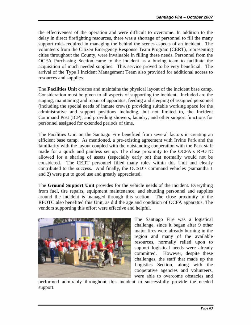
Santiago Fire – October 2007
Page 83
the effectiveness of the operation and were difficult to overcome. In addition to the delay in direct firefighting resources, there was a shortage of personnel to fill the many support roles required in managing the behind the scenes aspects of an incident. The volunteers from the Citizen Emergency Response Team Program (CERT), representing cities throughout the County, were invaluable in filling these needs. Personnel from the OCFA Purchasing Section came to the incident as a buying team to facilitate the acquisition of much needed supplies. This service proved to be very beneficial. The arrival of the Type I Incident Management Team also provided for additional access to resources and supplies. The Facilities Unit creates and maintains the physical layout of the incident base camp. Consideration must be given to all aspects of supporting the incident. Included are the staging; maintaining and repair of apparatus; feeding and sleeping of assigned personnel (including the special needs of inmate crews); providing suitable working space for the administrative and support positions including, but not limited to, the Incident Command Post (ICP); and providing showers, laundry; and other support functions for personnel assigned for extended periods of time. The Facilities Unit on the Santiago Fire benefited from several factors in creating an efficient base camp. As mentioned, a pre-existing agreement with Irvine Park and the familiarity with the layout coupled with the outstanding cooperation with the Park staff made for a quick and painless set up. The close proximity to the OCFA’s RFOTC allowed for a sharing of assets (especially early on) that normally would not be considered. The CERT personnel filled many roles within this Unit and clearly contributed to the success. And finally, the OCSD’s command vehicles (Samantha 1 and 2) were put to good use and greatly appreciated. The Ground Support Unit provides for the vehicle needs of the incident. Everything from fuel, tire repairs, equipment maintenance, and shuttling personnel and supplies around the incident is managed through this section. The close proximity to the RFOTC also benefited this Unit, as did the age and condition of OCFA apparatus. The vendors supporting this effort were effective and helpful.
The Santiago Fire was a logistical challenge, since it began after 9 other major fires were already burning in the region and many of the available resources, normally relied upon to support logistical needs were already committed. However, despite these challenges, the staff that made up the Logistics Section, along with the cooperative agencies and volunteers, were able to overcome obstacles and
performed admirably throughout this incident to successfully provide the needed support.

Santiago Fire – October 2007
Page 84
PAGE INTENTIONALLY LEFT BLANK

Santiago Fire – October 2007
Page 85
Incident Communications
During the first three days of the Santiago Fire, incident radio communications were all handled using the County of Orange 800 Mhz Countywide Coordinated Communications System (CCCS). The fire service in Orange County has been on the 800 Mhz System for the past 20 years, and since 1999, it has been a county-wide radio network shared by all public safety agencies in Orange County. There are over 15,000 mobile, portable and base station radios on the system servicing fire, law, public works and lifeguard agencies throughout the county. All mobile and portable radios have common channels for interagency communications. The 800 Mhz CCCS has proven to be a highly sophisticated and reliable communications system for the public agency users in Orange County. Several other fire and law agencies throughout Southern California use radios with common national 800 Mhz frequencies which are the same as those used on the Orange County System. The system is operated and maintained by the Communications Division of the Orange County Sheriff’s Department, which is headquartered at the Loma Ridge Communications facility This facility was briefly threatened on the first night of the Santiago Fire, but remained operational and no damage occurred. During the fire, the 800 Mhz System was never at full capacity. The system was designed and built to handle high volume radio traffic as experienced during the Santiago Fire, and no user experienced a "busy" signal at anytime during the incident. The Table below provides a comparison of daily 800 Mhz radio system number of transmissions.
Total Number of 800 Mhz CCCS Transmissions (All disciplines county-wide)
Date – 2007 Number of Transmissions
Date - 2006 Number of Transmissions
Sunday, 10/21/2007 67,584 10/21/2006 57,662 Monday, 10/22/2007 78,790 (1) 10/22/2006 50,516 Tuesday, 10/23/2007 78,983 (2) 10/23/2006 55,422 Wednesday, 10/24/2007 71,926 (3) 10/24/2006 55,877 Thursday, 10/25/2007 66,347 10/25/2006 57,379 Friday, 10/26/2007 67,330 10/26/2006 59,177 Saturday, 10/27/2007 62,641 10/27/2006 64,210
(1) This day represented the 6th busiest day in the history of the 800 Mhz CCCS (2) This day represented the 5th busiest day in the history of the 800 Mhz CCCS (3) This day represented the 10th busiest day in the history of the 800 Mhz CCCS

Santiago Fire – October 2007
Page 86
As indicated in the table, during the first 24 hours of the incident, there was a 50% increase in radio traffic on the system as compared to the same dates in 2006. This activity level continued through October 24th, (72 hours into the incident) and started to decrease as the United States Forest Service (USFS) VHF radio system was established for incident radio communications. As the incident expanded, and the federal Incident Management Team (IMT) arrived (October 24th) the National Incident Fire Cache (NIFC) was ordered to support the large number of resources responding from various agencies throughout the state and federal assets from out of state. The NIFC cache includes radios, repeaters, and common frequencies standard to all fire agencies throughout the country. All Orange County Fire Agencies maintain radios common to the system utilized with the NIFC radios on VHF (Very High Frequency) spectrum. The NIFC Cache maintains over 40,000 radios available for major incidents, such as Hurricane Katrina, earthquakes, and multiple fires as in the October 2007 Fire Siege. Resources responding are also required to have VHF radios as part of their Mutual Aid response equipment. Standard training on the operation and support of the NIFC system assigned to major incidents is provided throughout the year and the country. The change in radio systems during the fire occurred systematically during an operational period shift change. As of Thursday, October 25th, 800 Mhz transmissions were slightly higher than normal but not excessive, and by Sunday, October 28th, the 800 Mhz transmissions returned to normal levels. As the fire progressed, and more out-of-area resources arrived, (by October 26th) most of the fire communications had been moved to the VHF radio channels, although the 800 Mhz was still being used by the OCFA and other Orange County agencies for supplementary communications. A "patch" had been initiated between the VHF "Orange County Access" channel and the 800 Mhz "4C" talk group on October 23rd. This allowed any VHF radio being used at the incident the ability to communicate with command staff operating on the 800 Mhz system (channel 4C). This patch remained operational until the incident was closed out on November 10th. Feedback from Communications staff assigned to the incident, indicates this worked very well, and worked in places where the incident radio repeaters did not work. There were reports of VHF radios not being able to cover specific areas in Silverado Canyon. This problem is inherent in the VHF system utilized by the USFS, as well as other agencies on this older style radio system. This was corrected by placing a portable repeater in the Silverado Canyon area. Coverage and interoperability is always a safety concern when mixing radios from different systems, with different users. Commanders and supervisors had to take extra precautions to ensure any emergency radio traffic would be heard and acknowledged. There were also problems reported with individual users not being familiar with the radios or not following the Incident Communications Plan, which is a training issue and was reinforced during the incident.

Santiago Fire – October 2007
Page 87
There were other reports that the use of both 800 Mhz radios and VHF frequencies in the Incident Communications Plan was confusing for some, especially those who did not have both radios. For example, the Medical Unit used 800 Mhz radios to communicate with the ambulances and hospitals. Firefighters who did not have 800 Mhz radios were not sure what frequency to use to communicate with the Medical Unit. While this practice is acceptable during the initial attack phase, once federal or state assets arrive, the issuance of 800 Mhz radios causes complications for the users (use of two radios). The use of two radios is problematic when you are talking on one, and someone else is trying to reach you on the other. Once the USFS radio system was in place, 800 Mhz channels were removed from the Incident Communications Plan, with the exception of the Command Channel, which was used to patch the VHF Command Channel. This enabled users on either radio system to communicate with one another when the repeaters were patched together. Before the National Incident Fire Cache (NIFC) arrived, Orange County 800 Mhz radio resources were used exclusively. Prior to the Santiago Fire starting, a number of OCFA resources that responded as Mutual Aid to Los Angeles County earlier in the day on October 21st, had taken their 800 Mhz portable radios with them as they are part of the engine company’s standard equipment inventory. Placing 40 additional OCFA relief engines, training engines and extra engines into service used most of the OCFA’s portable radio cache, which is typically reserved to take to the incident base for distribution at large emergencies. Approximately 150 County pool radios were borrowed from OCC and programmed and prepared to support incident communications on the Santiago Fire, until the NIFC radio cache arrived. The Operations Section Chief for the incident was a very experienced OCFA Chief Officer who has been involved in a number of major disasters, including responding to Hurricane Katrina with OCFA’s Urban Search & Rescue Task Force. His personal observation was that the 800 Mhz System performed without problems and was better than any communications system he’s used during a disaster situation in other parts of the country.

Santiago Fire – October 2007
Page 88
PAGE INTENTIONALLY LEFT BLANK

Santiago Fire – October 2007
Page 89
Emergency Operations Center The Santiago Fire directly affected multiple jurisdictions, including the unincorporated County communities of Cowan Heights and Lemon Heights, and the cities of Irvine, Lake Forest, Tustin, Rancho Santa Margarita, and Orange. Residential, business, and commercial properties in the City of Irvine were threatened by the spread of the fire within the first 20-30 minutes, and the City activated their EOC at 6:30 p.m. The County EOC was activated shortly thereafter at 6:52 p.m. and remained activated until 6:00 p.m. on October 28th. As the fire spread over the next 36 hours, additional city EOCs were activated in Lake Forest on October 23rd at 9:00 a.m. and Rancho Santa Margarita on October 23rd at 1:00 p.m. While not directly affected by the fire in terms of evacuations or emergency activities, other cities contiguous to those that were affected, also activated their EOCs, for short periods of time. These included: Laguna Woods; San Juan Capistrano; and Anaheim. Staffing for each of the EOCs was provided by various county, city, or agency members, with a representative from OCFA assigned to those EOCs within OCFA’s jurisdiction that were directly affected, except for the City of Lake Forest. A shortage of trained staff led to not assigning a representative to this EOC. This resulted in the city having to deal directly with the OCFA DOC to acquire information and situation status for their EOC operations. This slowed communications with the Lake Forest EOC and caused some coordination issues.
The purpose of the County EOC is centralized emergency management for the Orange County Operational Area, where priorities are established; policy decisions are made; long term planning is carried out, and information flow and requests for resources other than firefighting specific resources are coordinated. During the activation of the County EOC, the Emergency Management Bureau through the Orange County Sheriff’s
Department (OCSD) provided the staff and logistical support for management of the EOC to ensure an effective operation. The EOC was staffed by representatives from various County Departments, as well as Operational Area agency liaisons. According

Santiago Fire – October 2007
Page 90
to the OCSD, this was the first time in Orange County’s history that the County EOC was activated on such a comprehensive scale for an actual event. Per the OCSD’s After Action Report regarding the County EOC efforts during the fire, many of the trained non-Emergency Management Bureau staff were unavailable for this activation as they were staffing Department Operations Centers. This resulted in a large number of individuals staffing the EOC with limited training and exposure to facility operations. In spite of this, interagency coordination functioned effectively, and coordination amongst EOC staff was seamless, despite the myriad of disciplines and agencies represented. This was attributed to the excellent support received from various DOCs and EOCs throughout the County. Due to the extraordinary demands the fire placed on all available management level personnel during the early stages, and a miscommunication, OCFA’s representative to the County EOC didn’t arrive until approximately 8:30 p.m. Upon his arrival, the assigned representative from OCFA filled the role of Director of Emergency Services, serving as the key decision-maker for the County EOC providing the direction and control necessary to accomplish the purposes specified in the Operational Area (OA) Agreement and responsibilities assigned as OA Lead as specified in Title 19, California Code of Regulations, Section 2409 (e). A change in the OCFA representative was made on Monday, October 22nd at 1:00 p.m. with the Emergency Planning and Coordination Battalion Chief being assigned to this role, and staying committed to the County EOC for the duration of the activation. It was noted in the OCSD After Action Report for the County EOC that the Orange County Fire Authority provided excellent policy direction. During the evening hours of Sunday, October 21st, within the first 2 hours of the fire, the County EOC which is located at the OCSD’s Loma Ridge Communications Facility was surrounded by fire. The EOC and Emergency Communications Bureau staff were sheltered in place during this time, and an OCFA Strike Team was assigned to protect the facility. Access was restricted for over two-hours as a result of this threat. Firefighters initiated an offensive backfiring operation, anchoring it to the single lane road that provides access to the EOC. This essential facility remained fully staffed and operational during this time, and structure protection resources were posted outside to deflect the fire and protect the facility in the event it became necessary. Firefighters burned out brush and grass fuels ahead of the main fire, and moved quickly to cut off the main fire. The backfire was successfully completed and eliminated the direct threat to the facility. City EOCs that were activated assisted in facilitating local issues in conjunction with the County EOC, such as evacuation of residents, coordination with evacuation centers, street closures, coordination with schools and businesses and coordination of local government resources. Over a 14 day period, a large number of residents were sheltered-in-place, in addition to voluntary and mandatory evacuations. On the first night of the fire, residents in the

Santiago Fire – October 2007
Page 91
unincorporated County communities of Lemon Heights and Cowan Heights were advised to shelter-in-place or voluntarily evacuate. Residents in the affected neighborhoods of Northwood and Portola Springs in the City of Irvine were advised to remain in their homes (sheltered-in-place). There was some early confusion about evacuations in Portola Springs that resulted in firefighters advising residents of an apartment complex in Orchard Hills, and a residential development in Portola Springs that the evacuation was mandatory. This was quickly corrected, but not before some residents did evacuate. A temporary “care and reception center” was established by the City of Irvine and the American Red Cross at the Lakeview Senior Center (located in Irvine) for residents of these two neighborhoods who may have mistakenly evacuated, as well as some other residents who didn’t feel comfortable with the “shelter in place” direction they had been provided. The center stayed open through the night to assist and serve residents until very early Monday morning, after all residents had safely returned to their homes. As the fire progressed overnight and during the daytime on Monday, October 22nd, voluntary evacuations and shelter-in-place orders were issued for Foothill Ranch and Portola Hills in the City of Lake Forest affecting over 6,000 residences. The Orange County Sheriff’s Department made the decision to evacuate 1,049 inmates and 36 staff members from the Musick Adult Detention Facility relocating them to other facilities during the daytime, and returning to the Musick Facility later that night when the fire threat to the facility was abated and air quality improved. Mandatory evacuations issued for populated rural canyon areas early Tuesday morning, October 23rd, affected over 1,300 residences, and an estimated 5,100 persons. In addition, 61 juveniles and 15 staff at the Joplin Juvenile Correctional Facility in the Trabuco Canyon area were evacuated and relocated. To accommodate residents displaced by evacuations during the Santiago Fire, there were two long-term evacuation centers established by the American Red Cross. One center was in proximity to the northern area of the fire at El Modena High School in the City of Orange which was open October 23rd through November 3rd, and the other in proximity to the southern area of the fire at El Toro High School which operated from October 21st through October 26th in the City of Lake Forest. Both centers were staffed by the American Red Cross volunteers on a 24/7 basis. The centers provided shelter, food, and other services for evacuees, including psychological support, minor medical care, and assistance with prescription

Santiago Fire – October 2007
Page 92
medication procurement. According to the Orange County Sheriff’s Department After Action Report, regarding County EOC Operations, approximately 372 evacuees were sheltered at these locations. (See EOC Attachment 1 - Red Cross Population Summary Information)
In addition, Orange County Animal Care Services sheltered-in-place approximately 150 animals in the field, impounded 212 animals, helped owners care for approximately 30 animals at the El Modena High School evacuation center and 156 animals at the El Toro High School. Many large animals (livestock) were sheltered at the Orange County Fair Grounds. Animal Care Services also assisted with the
transport of over 100 animals in the field from various canyon communities. Animals evacuated ranged from small animals (dogs, cats, chickens) to larger livestock (horses, goats, pigs, cows, and llamas). As the threat to structures began to subside, and there were no more evacuations, the City of Lake Forest EOC reduced their activation to level one status on the evening of Wednesday, October 24th and eventually deactivated their EOC on October 26th. The City of Rancho Santa Margarita also reduced their EOC activation level during the daytime on October 24th, and deactivated the same evening. The County EOC remained staffed and fully operational until the fire situation was further stabilized, and was ultimately deactivated and demobilized at 6:00 p.m. on Sunday, October 28th (one week after the fire had started). At this time the fire was over 27,000 acres and 50% contained and weather conditions had moderated. The only remaining threat to structures was in Silverado Canyon, where mandatory evacuations remained in effect until the afternoon of November 3rd. A number of other agencies activated their EOCs during the fire due to their involvement in the support of incident related activities, or potential impacts to services they provide. These included: • Various County Agencies and Departments, including: Health Care Agency,
Integrated Waste Management, and Resource and Development Management (RDMD)
• Coastline Community College District • American Red Cross • Orange County Transportation Authority • Santa Margarita Water District • Irvine Ranch Water District

Santiago Fire – October 2007
Page 93
The OCFA Department Operation Center (DOC) was activated at 11:00 a.m. on October 21st for advance planning due to weather conditions and regional fire activity. The DOC became fully staffed and operational for the Santiago Fire at approximately 6:00 p.m. on October 21st, and remained operational and staffed until the incident concluded on November 9th. The mission of the OCFA DOC is to provide support to major incidents with regard to resource requests, tracking of situation status, and handling incident communications without impacting normal emergency dispatch center operations. This is essential to ensure uninterrupted emergency services are being provided for all 9-1-1 calls, while devoting resources specifically to the major incident. The DOC also facilitated the backfill and staffing of relief apparatus for OCFA stations and personnel relief needs for the incident. A major responsibility of the DOC was serving as the central ordering point for the incident, which required the coordination of all requests and orders for emergency resources, personnel, and logistical support. This entailed a high level of coordination with local, state, and federal partners to ensure requests were filled as timely as possible. Additional ECC staff (dispatchers) had been held over for the communications portion of the DOC responsibility which worked very well. However, the fire spread so quickly, that the support staff that included a Division Chief and 2 staff Captains, were quickly overwhelmed with resources requests and phone calls. In an effort to gather intelligence and plot the fire spread, they were forced to rely on news media accounts (radio and TV) and cell phone updates from the Incident Commander. Eventually, additional staff were assigned to the DOC, and once the Planning Section for the incident was fully established, most of these problems were overcome. However, the rapid spreading nature of the incident proved to be very challenging from a situation status standpoint for the first 48+ hours. After the arrival of OCFA’s representative at the County EOC, communications between the County EOC and OCFA’s DOC were established and functioned effectively throughout the incident. However, the DOC staff struggled with communications to various level(s) of the Multi-Agency Coordination System which were activated at the geographical and state level, as well as the State EOC in Sacramento that was activated and staffed by Office of Emergency Services personnel. The flow of information and communications was burdensome due to the various entities involved at each of these levels, but were quickly sorted out. A Fire Mitigation Assistance Grant (FMAG) application was submitted to the Governor’s Office of Emergency Services (OES) Warning Center by DOC staff within 4 hours of the start of the Santiago Fire. Fire Management Assistance is available from FEMA to states and local governments, for the mitigation, management, and control of fires on publicly or privately owned forests or grasslands which threaten such destruction as would constitute a major disaster. The FMAG process is initiated when a State submits a request for assistance to the FEMA Regional Director at the time a "threat of major disaster" exists; and provides a 75% Federal cost share with the State

Santiago Fire – October 2007
Page 94
paying the remaining 25% for actual costs. Absent a federal disaster declaration, this would have ensured reimbursable funding for OCFA. However due to the Presidential Declaration of Major Disaster that was issued on October 23rd and granted on October 24th for all seven affected California counties, this became a moot point, as this declaration took precedence and automatically secured FMAG funding under the Robert T. Stafford Disaster Relief and Emergency Assistance Act (the Stafford Act).

Santiago Fire – October 2007
Page 95
Attachment 1 Santiago Fire/October & November 2007
Orange County Red Cross Shelter Population Information
El Modena High School
Community Registration Forms Completed
Total Registered Individuals
Modjeska 18 43 Silverado 95 204 Trabuco Canyon 1 5
Williams Canyon 1 1
% of Total 88% 84%
Lake Forest 1 2 Orange 1 4 Tustin 1 4
% of Total 2% 3%
Fallbrook 6 20 Running Springs 1 6
San Diego 4 9 Valley Center 2 4 Not Recorded 1 3
% of Total 10% 13%
Total Individual Registrations by Each Day
Overnight Shelter Count
% of Overnight Count to Total Registrations
23-Oct 120 12 10% 24-Oct 45 44 27% 25-Oct 26 28 15% 26-Oct 40 15 6% 27-Oct 2 26 11% 28-Oct 22 38 15% 29-Oct 29 38 13% 30-Oct 7 28 10% 31-Oct 5 17 6% 1-Nov 6 22 7% 2-Nov 2 20 7% 3-Nov 1 13 4%
Santiago Fire – October 2007
Page 96
El Toro High School
Community Registration Forms Completed
Total Registered Individuals
Modjeska 10 19 Silverado 14 29 Trabuco Canyon 13 38
% of Total 19% 19%
Foothill Ranch 5 14 Laguna Hills 1 3
Mission Viejo 1 3 Portola Hills 2 7 Rancho SM 1 1
San Clemente 2 5 % of Total 6% 7%
Carlsbad 2 8
Crestpark 1 1 Del Mar 3 4
Encinitas 1 1 Escondido 2 4 Fallbrook 122 284
La Mesa 1 3 Lake
Arrowhead 1 1
Paum Valley 1 2 Ramona 1 1
Rancho Santa Fe 1 2
Rimforest 1 2 San Diego 2 3
San Marcos 1 6 Valley Center 1 2
% of Total 74% 73%
Total Individual Registrations by Each Day
Overnight Shelter Count
% of Overnight Count to Total Registrations
21-Oct 20 9 45% 22-Oct 260 280 100% 23-Oct 93 300 80% 24-Oct 25 270 68% 25-Oct 15 11 3% 26-Oct 17 7 2% 27-Oct 8 0 0%

Santiago Fire – October 2007
Page 97
Media and Public Communications The Corporate Communications section of the OCFA was responsible for dissemination of information and public relations during the Santiago fire. The OCFA Media Center was activated almost immediately at the inception of the Santiago fire. Personnel were called back and answering phone calls from the public by 7:00 p.m., one hour after the fire was initially reported. From the inception of the fire until the fire was declared under control on November 9, 2007, the Media Center received almost 11,000 phone calls. The Media Center was staffed solely by six personnel from Community Relations and Education (CRES) until the third day of the incident when professional staff from Finance, Fire Prevention, and Human Resources were brought in to supplement the staffing. Unfortunately, there was not a regular schedule set up for the staff until about the fourth day of the incident. Since CRES staff were the only personnel with training in Media Center operations, the lack of a regular schedule forced some of the staff to work very long hours with no rest periods. In fact, some personnel had to work nearly 48 hours with no sleep. Once a regular schedule was established, operations went smoother, with staff from CRES being supplemented by personnel from other sections within the OCFA. As public inquires subsided to a manageable level, CRES staff were able to physically respond to the canyon communities to provide information to the residents. They did this by distributing flyers and personally speaking to residents. They made contact with approximately 500 residents and this action seemed to be very well received by the community. Early in the incident, it was very apparent that the OCFA Media Center could not handle a long, protracted major incident without some changes. The Media Center is not physically set-up properly to accommodate the number of staff required to handle an incident of such magnitude as the Santiago Fire. Staff reported that they lacked adequate work space, and that additional phone and data lines were needed. During the incident, five additional phone lines were added to the Media Center to handle the surge in calls. It was also difficult to rely on supplemental staffing from other sections, due to these personnel’s lack of familiarity with media center operations and public relations.

Santiago Fire – October 2007
Page 98
The OCFA website received over 18 million hits in October and almost 3 million hits in November. During the first 12 hours of the fire, there were 800,000 hits to the OCFA website and website hits peaked to almost 4 million hits during the third day of the fire (October 23). To put this in perspective, the average number of website hits is around 650,000 per month. It was very obvious that the public was using the website to get information on the fire. OCFA personnel updated the website as often as possible, even providing a fire progression map every 12 hours of the incident. Although staff received compliments on the website, there were also complaints that the website was not easy to navigate and was not updated often enough. There are very few personnel trained to update the OCFA website and updating is a very manual and cumbersome process. According to Corporate Communications, there were times that updated fire information became available, but there were no personnel at the Media Center trained or authorized to make updates to the website. It was also noted, that information from the Incident Command Post and the County EOC was sometimes difficult to gather, which resulted in delays to the website update at times. OCFA experienced several difficulties in the Public Information Officer (PIO) function during the fire. Initially, OCFA was inundated with media inquiries and there was some confusion as to the response by OCFA’s PIO. As a result, the Corporate Communications Battalion Chief (BC) had to respond to media inquiries. Early in the incident, all media inquiries were referred to the Corporate Communications BC which quickly overwhelmed him and did not allow him to perform other required duties such as managing the Media Center and issuing Board Advisories in a timely manner. In fact, during the first week of the incident the Corporate Communications BC conducted an average of 40–50 interviews per day (television, radio, and print media). By the sheer magnitude of media inquiries, it became apparent very early in the incident that additional field PIOs were needed. Additional PIOs were requested from neighboring agencies. Irvine Police provided a PIO to assist with management of the Media Center during the second day of the incident. Orange City Fire and Santa Ana Fire both assisted by providing PIOs for the incident. These additional local PIOs were particularly helpful in handling the political issues resulting from the fire. Response to media inquiries by the PIO and the Corporate Communications BC was somewhat uncoordinated during the first few days of the incident resulting in some confusion, especially in the dissemination of evacuation information. During the first night of the incident, information was communicated to the residents that the evacuations were mandatory, when, in fact, the Incident Commander specifically designated the evacuations as voluntary. This led to some confusion with the community and it was perpetuated by the media in the field interviewing the residents. This was quickly corrected with the media. The Incident Management Team PIO arrived during the third day of the incident as part of the team that was requested. Unfortunately, the IMT PIO did not have local knowledge of the unique nature of the Southern California media market. This problem

Santiago Fire – October 2007
Page 99
was compounded by the fact that there were political issues that needed to remain with the OCFA PIO. It was mutually decided to have a unified PIO function with the IMT PIO handling strictly operations information. The OCFA PIO would maintain media relations with regard to any political issues resulting from the fire as well as any information regarding the investigation of the cause of the fire. Corporate Communications also retained all communication responsibilities with the OCFA Board, city managers, and other elected officials. Communications between the OCFA Media Center and the Orange County Emergency Operations Center (EOC) was efficient throughout the incident. A total of 63 press releases and media advisories, with information on evacuations, road closures, and school closures, were issued in a coordinated fashion between the Media Center and the EOC. There was also good communication between the Media Center and the city EOCs that were activated due to the fire. In particular, evacuations in Foothill Ranch and Portola Hills were very well coordinated with the City of Lake Forest EOC. Corporate Communications issued Board Advisories, via e-mail, to OCFA’s Board of Directors and city managers at critical junctures of the incident. These were a good tool to reach the Board of Directors and City Managers in a quick and timely manner. The advisories generated inquiries by some board members and the Corporate Communications BC was able to respond to most of these inquiries. As a result of the Corporate Communications BC acting as the incident PIO, there were only 12 Board Advisories issued during the fire. It would have been optimum to issue a Board Advisory at least once a day. The Corporate Communications BC was also responsible for escorting board members and other dignitaries into the impact zone. This went relatively well. There were a few times during the incident that the BC was unavailable to escort dignitaries due to other priorities and functions. In these cases, members of the Executive Management staff were able to escort the dignitaries.

Santiago Fire – October 2007
Page 100
PAGE INTENTIONALLY LEFT BLANK

Santiago Fire – October 2007
Page 101
Arson Investigation At the initial report of the Santiago Fire, the on-duty Fire Investigator automatically self-dispatched from the RFOTC to the origin of the fire. The Duty Investigator’s initial actions included identifying the fire’s origin and identifying and eliminating possible sources of ignition. Within the first hour of the investigation, the preliminary findings indicated that the cause was arson. Continuing investigation efforts over the next four days confirmed these findings. Due to the initial cause determination of arson, and the threat to federal forest lands, the local office of the FBI contacted OCFA Investigation Services and offered their assistance. Within the first 24 hours of the fire, the Federal Government enacted the “National Response Plan.” As required by Homeland Security Presidential Directive (HSPD)-5, the National Response Plan (NRP) establishes a single, comprehensive approach to domestic incident management to respond to and recover from major disasters and other emergencies. This prompted the local office of the ATF to also offer support to this investigatory effort.
As a result of this activation, representatives from the Alcohol Tobacco and Firearms (ATF) and Federal Bureau of Investigation (FBI) responded to the RFOTC to provide investigative support to OCFA staff. Additionally, Cal-Fire and the Orange County Sheriff’s Department (OCSD) provided agency representation and technical support throughout the initial stages of the investigation. These additional resources resulted in an investigation task force in excess of 160 persons.
OCFA Investigations Services Section (ISS) assumed responsibility as the lead agency in charge of the investigation and retained command of the task force. A division of workload was accomplished by dividing the investigations responsibilities into three separate investigative divisions: Origin and Cause, Interviews, and Technical Support. OCFA and Cal-Fire conducted the Origin and Cause investigation. All agencies participated in the interviews and provided technical support where/when needed.
OCFA’s “1-800-Tip line” was broadcast to the public, through local and national media, requesting public assistance throughout the initial investigation stages. This request for information along with reward monies totaling $250,000 resulted in over 1,200 investigative leads during the first 12 days of the incident. The reward money was pledged by KFI Radio ($150,000), ATF ($50,000), and the FBI ($50,000).
The Investigation Task Force was staffed for the first 12 days of the incident; with office space provided at OCFA’s Headquarters in Irvine. OCFA professional staff installed and provided numerous telephone and data lines into the office space to support the investigative efforts.

Santiago Fire – October 2007
Page 102
Coordination of the investigation included: • Daily coordination meetings facilitated by OCFA with agency representatives
from ATF and FBI (Cal-Fire and OCSD when available.) • Daily morning and evening briefings with staff from all involved agencies • Evidence analysis
After the first 12 days of the incident, having handled a majority of the initial leads, and with additional leads reduced to approximately 5-8 per day, the Task Force was downsized significantly. The continuing investigation efforts are currently being handled by the OCFA Investigations Services Section with members from all other participating agencies available should their expertise or resources be needed.
Current ongoing investigative efforts include: • Continuing follow-up on leads received on the “1-800-Tip line” • Continuing to work previously identified leads which have the potential of
identifying a responsible person(s) • Ongoing review of the investigation process to ensure all aspects of the
investigation have been thoroughly followed-up • As of early February, over 1,300 tips have been received and followed up on.

Santiago Fire – October 2007
Page 103
Volunteer Groups and Resources A number of volunteer groups assisted during the Santiago Fire in various capacities. Major volunteer groups included the following: • American Red Cross • Inter-Canyon Fire Safe Council • Canyon Watch • Community Emergency Response Team (CERT) • OCFA Chaplains • Salvation Army • Trauma Intervention Program (TIP) These volunteer groups provided invaluable assistance to a wide variety of non-suppression and incident support activities. The positive attitude, helping nature and initiative of all of these groups was recognized and appreciated by OCFA staff, the Incident Command staff, and those who were responsible for supervising and managing various support functions. The Red Cross is the lead agency responsible for establishing and staffing evacuation centers during disasters, and other types of major emergencies requiring evacuation of large numbers of residents. During the Santiago Fire, there were two long term evacuation centers established, one in proximity to the northern area of the fire at El Modena High School in the City of Orange which was open October 23rd through November 3rd, and the other in proximity to the southern area of the fire at El Toro High School which operated from October 21st through October 27th in the City of Lake Forest. (Reference: Emergency Operations Center Section for additional information regarding evacuation centers.) The Inter-Canyon Fire Safe Council representing the canyon communities of Silverado, Williams, Modjeska and Trabuco has been a long time partner with the OCFA in wildland fire prevention efforts in these rural canyon communities. Their focus is fire prevention through community awareness. They conduct research and apply for grant funds available to help facilitate these prevention related activities in their local communities. The group was a major contributor to the development of the Silverado Fire Plan that was used during the incident, and have also assisted by providing written input to the State’s Fire Plan. This is a fire plan for wildland fire protection in California developed by CAL FIRE. The goal of the plan is to reduce the overall costs and losses from wildfire in California. Fire Safe Councils throughout California are playing an integral role helping CAL FIRE achieve this goal. A major effort of the Inter-Canyon Fire Safe Council in conjunction with OCFA, is the annual Operation Canyon Clean Sweep, where residents are encouraged to trim vegetation around their property, and clean-up fire hazards. The Fire Safe Council also

Santiago Fire – October 2007
Page 104
sponsors “Chipper Days”. This is an event that occurs one (1) weekend every other month. It encourages canyon residents to clear flammable vegetation, and keep it cleared, on a year-round basis. Grant funding from the Statewide Fire Safe Council’s clearinghouse supports this endeavor and pays for costs incurred from Orange County Conservation Corp, chipper rental, and any disposal fees. Canyon Watch is not officially affiliated with any governmental agency; however they are informally affiliated with the Inter-Canyon Fire Safe Council. They are also associated with, but not a formal part of Radio Emergency Associated Communications Teams (REACT) or Citizen Radio Emergency Service Team (CREST). Canyon Watch is a group of highly dedicated volunteers from the populated rural canyon communities of Silverado, Modjeska, Trabuco and other contiguous canyon communities, that have formed a network of concerned residents that primarily patrol these canyon communities during extreme Santa Ana wind conditions, Halloween and July 4th. The group organizes their patrols in teams of two people, and generally patrol after night fall. Members of this group have several base station type radios that are informally monitored by volunteers 24/7. The purpose of the group is to conduct patrols in high risk, fire prone canyon areas and discourage illegal or dangerous acts that may lead to a devastating fire start. During the Santiago Fire, the group was asked to assist Orange County Sheriff’s Deputies and OCFA personnel with evacuations, and ensuring that all canyon residents got the word regarding evacuations and related information. The group also provided an invaluable communications link with evacuees from these canyon communities. The Community Emergency Response Team (CERT) Program educates people about disaster preparedness for hazards that may impact their community and trains them in basic disaster response skills, such as fire safety, light search and rescue, team organization, and disaster medical operations. Using the training learned in the classroom and during exercises, CERT members can assist others in their neighborhood or workplace following an event when professional responders are not immediately available to help. CERT members also are encouraged to support emergency response agencies by taking a more active role in emergency preparedness projects in their community. CERT is part of the Federal Government's Citizen’s Corp Program.
Approximately 245 CERT volunteers from 15 different cities throughout the county, assisted in support roles during the Santiago Fire. Some of the functions that CERT volunteers performed were check-in and security at the front gate at Irvine Park where the incident base camp was located, receiving and distribution of lunches, drinks, and
donated items such as shower supplies, socks and health care products. They also assisted as runners in base camp, for delivering messages and supplies, and provided

Santiago Fire – October 2007
Page 105
drivers for a variety of needs. One of the Logistics Section Chiefs assigned to the incident stated “One of the most appreciated tasks they took on and managed perfectly, was the scheduling and coordination of their own. All I needed to do was let them know how may people we thought we would need and they took care of ensuring we had that many or more 24/7 throughout the fire. They were simply awesome”. The contribution and effort of this particular group of volunteers was a great aid to incident logistical support. OCFA has a long standing and very active volunteer Chaplain Program. Members of the Chaplain Program were on-hand and available to support and assist residents with spiritual needs during this crisis, as well as helping with other non-suppression support duties. The Volunteer Chaplains from OCFA, assisted full-time staff who were assigned as Occupant Liaisons to escort evacuees to their homes to retrieve personal belongings during the evacuations. They also provided counseling upon request to individuals and families who suffered losses during the fire. Throughout the fire, Volunteer Chaplains were a visible presence at what came to be known as “Camp Silverado” where they assisted with spiritual and emotional needs, and also arranged for feeding of evacuees at this location by several churches and restaurants in the local area. OCFA Senior Chaplain Warren Johnson acted as liaison with the Salvation Army (where he is a full-time employee) which was a major resource for food, shelter, and other emergency needs for evacuees. Six members of the OCFA Volunteer Chaplain Program assisted during the fire, donating over 500 hours. The Salvation Army has a long history of reaching out to others, in times of emergencies or disasters. During the Santiago Fire, the Salvation Army Tustin Ranch Church provided assistance and support to evacuees and those canyon area residents who congregated at Camp Silverado. Assistance included food, clothing and personal items. The Trauma Intervention Program (TIP) is a non-profit volunteer organization of specially trained citizen volunteers who provide immediate emotional and practical support to victims and their families in following a tragedy or traumatic event. TIP provided volunteers to assist with counseling residents who had been evacuated or whose homes were destroyed or damaged. Approximately 12 TIP volunteers worked varying shifts each day of the fire. They were effective in encouraging evacuees, assisting with the Occupant Liaison Center (Camp Silverado) and working as family escorts when needed, during the Occupant Liaison Program. The TIP Manager was particularly helpful in scheduling volunteers throughout the fire, and the individual TIP volunteers were considered an excellent addition to the Occupant Liaison Program. The account of what came to be known as “Camp Silverado” is a special story that exemplifies the true “volunteer spirit” that emerged early in the Santiago Fire, when residents of the various rural canyon areas threatened by the fire were forced to evacuate. This became more pronounced when residents of the close knit community of Silverado Canyon were given a mandatory evacuation order early in the morning on Tuesday, October 23rd.
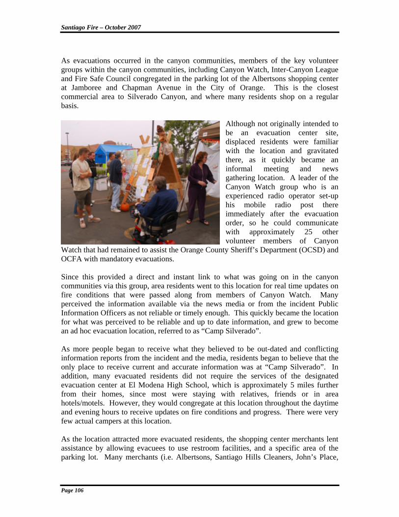
Santiago Fire – October 2007
Page 106
As evacuations occurred in the canyon communities, members of the key volunteer groups within the canyon communities, including Canyon Watch, Inter-Canyon League and Fire Safe Council congregated in the parking lot of the Albertsons shopping center at Jamboree and Chapman Avenue in the City of Orange. This is the closest commercial area to Silverado Canyon, and where many residents shop on a regular basis.
Although not originally intended to be an evacuation center site, displaced residents were familiar with the location and gravitated there, as it quickly became an informal meeting and news gathering location. A leader of the Canyon Watch group who is an experienced radio operator set-up his mobile radio post there immediately after the evacuation order, so he could communicate with approximately 25 other volunteer members of Canyon
Watch that had remained to assist the Orange County Sheriff’s Department (OCSD) and OCFA with mandatory evacuations. Since this provided a direct and instant link to what was going on in the canyon communities via this group, area residents went to this location for real time updates on fire conditions that were passed along from members of Canyon Watch. Many perceived the information available via the news media or from the incident Public Information Officers as not reliable or timely enough. This quickly became the location for what was perceived to be reliable and up to date information, and grew to become an ad hoc evacuation location, referred to as “Camp Silverado”. As more people began to receive what they believed to be out-dated and conflicting information reports from the incident and the media, residents began to believe that the only place to receive current and accurate information was at “Camp Silverado”. In addition, many evacuated residents did not require the services of the designated evacuation center at El Modena High School, which is approximately 5 miles further from their homes, since most were staying with relatives, friends or in area hotels/motels. However, they would congregate at this location throughout the daytime and evening hours to receive updates on fire conditions and progress. There were very few actual campers at this location. As the location attracted more evacuated residents, the shopping center merchants lent assistance by allowing evacuees to use restroom facilities, and a specific area of the parking lot. Many merchants (i.e. Albertsons, Santiago Hills Cleaners, John’s Place,

Santiago Fire – October 2007
Page 107
Subway) also provided items such as bottled drinking water, food, personal toiletry items and temporary electrical power. Various volunteer organizations such as the Salvation Army, TIP, OCFA Volunteer Chaplains and others assisted evacuees at Camp Silverado. The OCFA arranged for the incident to provide portable toilets, and some basic amenities at this location. The formation of this ad hoc evacuation center (Camp Silverado) became problematic to the incident management personnel as evacuees began to feel that they were being provided “canned” or crafted information. Some residents who had remained in their canyon area homes, were passing along information they believed to be accurate based on their personal observations, which in fact were not always correct, accurate, or based on actual fire situation status and conditions. The establishment of informal type ad hoc type evacuation centers during a disaster is not uncommon. In fact, many similar type locations surfaced following the Northridge Earthquake in Los Angeles in 1994 and during Hurricane Katrina in 2005. As time progressed and fire conditions improved, the residents of Modjeska Canyon and other canyon communities were permitted to return to their homes. However, the residents of Silverado Canyon who had been displaced for over a week were still under a mandatory evacuation order, as the fire continued to threaten this community. Fire Chief Prather met personally with evacuees at Camp Silverado to assure them that their concerns were being addressed, that aggressive actions were being taken to protect their homes and that they would be permitted to return to home as soon as conditions improved and it was no longer dangerous. He also assured evacuees that he would take steps to ensure that information was provided in a more timely fashion. Late in the day on October 23rd, OCFA took action to implement its Occupant Liaison Program, whereby selected OCFA staff with fire department vehicles were made available to escort evacuated residents to their homes in the fire area for brief periods of time to retrieve personal belongings, a pet or prescription medications. Most of those who took advantage of this service were residents of Silverado, Modjeska, Williams, Black Star, Baker, Ladd and Baum Canyons. Between October 23rd and October 31st, an estimated 1250 canyon area residents (many repeats), availed themselves of this service, and were very complimentary about OCFA’s willingness to provide this level of personal assistance to evacuated residents. One couple was so moved by the OCFA's response and follow-up, that despite losing their home, they donated $2,500 to the OCFA over the holidays. Residents of Modjeska and Williams canyons, whose homes were destroyed by the fire were handled differently than those who needed to pick up pets, personal belongings or prescription medications. These residents were escorted to the RFOTC (Orange County Fire Authority Headquarters) which is located approximately 3 miles from the site of Camp Silverado. They were provided counseling by volunteer members of the Trauma Intervention Program (TIP) and the services of OCFA’s volunteer Chaplains was made available to them. They were personally driven to their home site and escorted around their property by an OCFA staff member. Questions were answered regarding fire

Santiago Fire – October 2007
Page 108
behavior and what kind of firefighting efforts were taken by firefighters to protect their properties. Counseling often continued onsite by TIP and the OCFA Chaplains, and efforts were made to locate and salvage a few personal mementos. These sessions were very emotional, and often lasted several hours or more. Upon their return to the RFOTC, these residents were given "Disaster Recovery Handbooks”, FEMA contact information, OCFA’s fire incident number (for future reference), and a mental health referral for those who requested one. There were many other accounts of individual volunteers stepping forward to provide assistance during the Santiago Fire, such as the small group who purchased food and set-up at Cook’s Corner Roadhouse in Trabuco Canyon to feed fire crews in the area, and local restaurants that donated pizzas and other food items for firefighting personnel. There were numerous accounts of individual residents providing food, water and comfort items to firefighters who were assigned to protect residential neighborhoods, and generous individuals who provided monetary donations. It’s simply not possible to identify each group or individual by name. However, it is important to acknowledge that having trained, qualified and eager volunteers from these groups, capable of assisting in non-suppression activities, freed full-time firefighting personnel and resources to focus solely on fire suppression efforts. In addition they assisted greatly in providing human services, aid and comfort to residents who were evacuated, as well as those residents whose homes were damaged or destroyed. The contributions and assistance of all of these volunteer groups, and the individual volunteers themselves was invaluable.

Santiago Fire – October 2007
Page 109
Fiscal Impacts
Overview of Costing and Reimbursement Procedures for Major Incidents Each year, the OCFA establishes Cost Reimbursement Rates which are used to bill for personnel and equipment resources that are requested on an assistance-by-hire basis by state, federal, and other agencies needing OCFA services. The personnel rates are based on budgeted salary and benefit costs and also include indirect costs such as financial services, purchasing, and human resources. Equipment rates are based on rate schedules provided by CAL FIRE and the Federal Emergency Management Agency (FEMA). These rates are used to recover OCFA’s costs when assisting other agencies, or when an OCFA incident is declared a major incident subject to Public Assistance Funding. Public Assistance Funding Public Assistance Funding is authorized by the Stafford Act and funded through FEMA. The Stafford Act provides for the following:
• Gives the President the authority to administer Federal disaster assistance • Defines the scope and eligibility criteria of the major disaster assistance programs • Authorizes grants and direct assistance to the States • Defines the minimum Federal cost-sharing levels
Santiago Fire Costs As of March 1, 2008, OCFA’s costs from the Santiago Fire are estimated at $6.6 million. Due to the magnitude of the fire, both FEMA and the State’s Office of Emergency Services (OES) declared the Santiago Fire as a major incident and offered to provide Public Assistance Funding to the participating agencies. Following guidelines for Federal Public Assistance, on October 31, 2007, a Local Government Fiscal Responsibility Agreement was made between CAL FIRE, FEMA/OES, and OCFA concerning reimbursement of resources for the Santiago incident. Based on the Local Government Fiscal Responsibility Agreement, OCFA expects reimbursement of at least 95% of costs associated with the Santiago Fire. Costs and the source of anticipated reimbursements are as follows: Types of Costs FEMA/OES CAL FIRE Total *
Labor $200,000 $5,000,000 $5,200,000Supplies 450,000 450,000Equipment 1,000,000 1,000,000Total * $200,000 $6,450,000 $6,650,000
• There are additional minimal costs which OCFA will not be reimbursed for. These non-
reimbursable costs are still being reviewed and tabulated. Staff anticipates completion of the full Santiago Fire cost tabulation by March.

Santiago Fire – October 2007
Page 110
PAGE INTENTIONALLY LEFT BLANK

Santiago Fire – October 2007
Page 111
Recovery Efforts Long before the Santiago Fire was officially declared under control, the OCFA and a number of other agencies were actively engaged in recovery and rehabilitation efforts. As the fire approached the Canyon Communities the OCFA realized that other than the obvious fire threat, there was a short-term and long-term environmental threat in the form of debris flow and flooding. Commanders knew all too well the dangers that floods and mudslides could bring to these areas, especially Silverado Canyon, where a massive mudslide occurred in 1969, killing 5 people who had sought refuge at the local fire station, including 3 Volunteer Firefighters, and destroying the fire station. A rockslide triggered by rains, in this same community resulted in a large boulder crashing through a business/home and killing teenaged girl in February, 2005. The Incident Commanders were given very specific direction by the OCFA Fire Chief that every effort be made to use fire control tactics in Silverado Canyon that took into account the history of disastrous flooding in this community, as well as in other populated rural canyon areas. Although far more difficult and hazardous, direct attack methods were employed to make every effort to contain the fire in the smallest footprint within these communities and on the surrounding canyon walls and ridgelines. This tactical approach was critical to maintaining vegetation that would help to buffer future flood runoff. These tactics were particularly challenging in the Silverado Canyon area, with its steep canyon walls and rocky landscape. This “direct attack” effort was manpower intensive as it required handcrews and equipment to work directly on the fires edge, in steep almost inaccessible terrain under the most difficult of fire behavior conditions. This also resulted in Silverado Canyon residents remaining evacuated for an extended period of time until the fire was completely contained to ensure their safety. Although much more difficult and protracted, these efforts were eventually successful and the fire was held out of Silverado Canyon in all but a few areas. In addition to the selected tactics employed in the Silverado Canyon area, other recovery activities were underway prior to the fire being contained and declared under control. From October 26th to November 5th, a Local Assistance Center (LAC) was established in the City of Irvine (125 Technology Drive West, Suite 22) in an effort to provide

Santiago Fire – October 2007
Page 112
displaced residents a one-stop location to replace important personal identity information and paperwork that had been lost or destroyed, and to obtain a variety of assistance from local, state, and federal agencies. Agencies on-site at the LAC included but were not limited to: various County health, human, and social services, DMV, Veterans Assistance, State Board of Equalization, Office of Emergency Services, Contractor’s State License Board, State Franchise Tax Board, Small Business Administration, and various utility companies. A second smaller Local Assistance Center was opened at the Salvation Army Tustin Ranch facility from October 28th to November 5th. Services available at this location, included: Various County health, human, and social services, as well as the Red Cross and Salvation Army. Following the destructive series of Southern California wildfires included in the Presidential Disaster Declaration FEMA-1731-DR-CA, local, state, and federal authorities realized the need for a unified approach to assess the post fire risks to lives and property that may arise during the 2007 – 2008 winter rainy seasons. The fires burned a combined area in excess of 520,000 acres throughout Southern California. The combined effects of vegetation loss, as well as, the effect on soils from the fire, create conditions that greatly increase the threat of flooding, erosion, and debris flows into watersheds throughout Southern California. To facilitate a coordinated response to the post fire risks, the Multi Agency Support Group (MASG) was formed which consisted of State and Federal agency representatives. The MASG enlisted Burn Area Emergency Response (BAER) teams which consisted of programmatic and technical experts to assess the burn areas and prepare BAER Reports which outlined potential areas of concern. The Burn Area Recovery Task Force (BARTF) teams were then formed under the direction of the MASG to assist the affected counties with evaluation of potential hazards, development of potential remediation to these hazards, and coordination of potential funding sources for possible projects. The identified risks were then evaluated and potential emergency protective measures were identified. For the first time, the State of California implemented a BAER assessment in response to the fires of October/November 2007. The BAER teams were composed of representatives of multiple State agencies and disciplines. An initial BAER assessment has been completed for the 2007 Santiago Fire. The State BAER assessment had four key objectives: • Identify on-site and downstream threats to public health or safety and property from
landslides, debris torrents, flooding, road hazards, and other fire related problems. • Identify threats to watershed resources including excessive erosion; impaired water
quality; threats to wildlife, botanical values, or fisheries; and threats to cultural resources.

Santiago Fire – October 2007
Page 113
• Identify any other values at risk not previously identified, for example recreational resources.
• Determine measures needed to prevent or mitigate identified threats. The BAER team assigned to the Santiago Fire conducted surveys on burned areas prior to fire containment on November 9th. The purpose of the surveys was to determine if emergency rehabilitation treatment are needed to minimize the risk of threats to human life or property. These surveys also assess if emergency rehabilitation treatment is needed to minimize or prevent deterioration of water quality, minimize loss of soil productivity due to erosion, minimize or prevent degradation of wildlife and botanical habitat, and minimize or prevent degradation of cultural resources. These surveys also facilitate identification of other potential values at risk (for example recreational resources), and determination if emergency rehabilitation treatment is needed. As part of its assessment, the BAER team did not evaluate that part of the fire located on the Cleveland National Forest. This task was accomplished by a United States Forest Service (USFS) BAER team. However, contact amongst the two teams did occur, including the sharing of information. It is acknowledged the USFS BAER team provided valuable assistance to the State BAER. The BAER Team concluded that the fire and the impact have resulted in an increased risk for storm events to result in flooding, debris torrents, and debris flows. As storm intensity or duration rises, the threat posed by flooding, debris torrents, and debris flows includes the loss of life and property. All values at risk identified could be adversely affected. The draft BAER report completed November 15, 2007 for the Santiago Fire is a very comprehensive 86 page document, with maps, charts, and tables. The report has been distributed to affected local, state and federal agencies, and is available on the internet from the Governor’s Office of Emergency Services at www.oes.ca.gov. (See Recovery Attachment 1 - List of Santiago State BAER Team Members and Advisors) Orange County 3rd District Supervisor and OCFA Board Member Bill Campbell hosted a Post Fire Recovery town hall meeting on November 6th for canyon area residents. The meeting was held at the Silverado Community Center, with over 200 residents in attendance. Representatives from local agencies included: OCFA, Orange County Sheriff’s Department, County

Santiago Fire – October 2007
Page 114
Planning Department, Waste Management, Health Care Agency and Assessor’s Office. In addition state and federal representatives including Office of the Governor, State Office of Emergency Services, and the U.S. Forest Service were in attendance. Representatives from Southern California Edison, AT&T, and Irvine Ranch Water District were also in attendance. The meeting included a presentation regarding erosion control and a discussion about measures to limit flooding during the rainy season, and a question-answer session for residents. The Inter-Canyon League hosted additional community meetings at the Modjeska Canyon Fire Station on Thursday, November 29 and at the Calvary Chapel of the Canyons church in Silverado Canyon on December 3rd. The purpose of these meetings was to address what residents should expect as a result of the fires and how to prepare and respond to future emergencies. Representatives were in attendance to discuss the BAER report findings and flood control measures that residents could implement on their own. As part of the ongoing post fire recovery efforts, the U.S. Geological Survey (USGS) installed a real time web camera near Santiago Creek at the Modjeska Canyon stream-gauging station. This webcam is located beside the USGS stream-gauging station on the Santiago Creek at Modjeska Canyon on the western slope of the Santa Ana Mountains in eastern Orange County. The Santiago Creek site is the first new camera to be installed, with priority given based on the BAER team report that was developed. The gauge provides continuous monitoring of river flow, stage, and precipitation. The flow at the gage is slightly regulated by the Modjeska Reservoir, located about 1.5 miles upstream in Harding Canyon. In October 2007, over 28,000 acres of the drainage area above this gage were burned during the Santiago Fire, making it a high-risk site for flooding. The webcam's visual record of flooding and potential debris flows provides valuable research data for the USGS. Monitoring and research data are being collected in partnership with the National Weather Service, Orange County Fire Authority, and Orange County Environmental Resources Division (ERD). The National Weather Service uses USGS stream flow and rain data, and County ERD rain data, in analyzing flood potential and issuing Flood Watches and Warnings. FEMA and the State Office of Emergency Services are coordinating recovery and risk assessment efforts in all burn areas in Southern California. This webcam installation is part of the USGS Multi-Hazards Demonstration Project. The USFS participated in post fire recovery and rehabilitation assessments as part of the process called the BAER response. The USFS is planning post fire recovery actions in coordination with other federal agencies, and state and local agencies with jurisdiction over lands where life and property are at risk from post-fire conditions. These actions are based on recommendations contained in the BAER report, including work on forest roads that are at risk from post-fire runoff, treatments to maintain 7 miles of popular and heavily used trails including signage to warn users, and the installation of pipe rail barriers at sites highly vulnerable to intrusion by off road vehicle use onto Forest land from adjacent privately owned lands.

Santiago Fire – October 2007
Page 115
Based on the BAER Team Report, resource specialists have recommended and funding has been obtained to treat 1,241 acres of Forest Service lands with aerially-applied hydromulch. These lands are where the fire intensity was rated as high and the slopes are less than 50%. The Santiago Fire burned a total of over 28,000 acres, but most of the high-intensity burned acres were on the 6,701 acres of Forest Service lands located at the east end of the fire in the higher elevations. Helicopters and fixed wing air tankers applied the layer of hydromulch, which is a wet mixture of 40% shredded wood and 60% paper, with a guar gum based pacifier, a sticky substance that helps the mulch material cling to hillsides and steep slopes (Guar gum is used in ice cream as a thickener). The green-dyed biodegradable hydromulch stabilizes the soil and provides a nutrient media for new plant growth on fire-damaged lands. After drying it will harden and turn gray. It will intercept some of the rain’s impact energy and minimize erosion. No seed or fertilizers are included in the hydromulch mixture. Aerially applied hydromulch is a major component of a rehabilitation plan that will cover areas that are mostly inaccessible by other ground-based methods or cannot be treated in a timely manner. Hydromulch is an organic mixture that poses no threat to humans, wildlife, or the environment. Numerous fundraising activities and efforts have occurred since the fire, to provide disaster relief and aid to canyon area residents. Shortly before the last mandatory evacuation order was lifted for Silverado Canyon on November 3rd, canyon area residents gathered to plan how to re-build their community and help those who lost their homes. Under the leadership of the Inter-Canyon League a Santiago Fire Relief Fund was established. The goal of the Santiago Fire Relief Fund is to raise and distribute funds to those in need of both immediate and long term assistance. The ICL is a non-profit volunteer organization dedicated to protecting and preserving the canyon’s unique way of life. Because the ICL is a 501 (c) 3 organization, all contributions to the fund are tax deductible, and all funds raised go directly to those in need, with no overhead expenses deducted. To date, efforts have ranged from the sale of Modjeska Firehouse 16 tee-shirts to garage sales and donations from individuals and businesses. The Inter-Canyon League (Santiago Fire Relief Fund) received a donation from an anonymous donor in the amount of $1 million for the fire relief efforts in the canyons and to help victims of the Santiago fire rebuild their homes and lives. Additional assistance has been provided by the Salvation Army, American Red Cross, local area churches, and other community groups and individuals. At their November 20, 2007 meeting, the Orange County Board of Supervisors took action to allocate $100,000 to the Orange County Community Foundation (OCCF) as part of a public-private partnership to aid those Orange County residents who were affected by the fire. With the allocation of these funds, the OCCF will identify organizations with demonstrated and specific needs in connection with the Santiago Fire relief effort. Any remaining funds that are not used in response to the Santiago Fire relief effort will be placed into a permanent Orange County Disaster Relief trust

Santiago Fire – October 2007
Page 116
fund to be held by the OCCF. Individuals and private sector businesses will be able to make charitable contributions to this fund as well. In the event of future disaster declarations made by the Board of Supervisors, this permanent Disaster Relief Fund will be in place to aid in the response effort. The permanent fund will also help to expedite the allocation of these funds in a timely manner.
The OCFA and other County agencies began immediate planning for flood related emergencies in the burn areas before the fire was under control on November 9th. This included the development of contingency plans for populated rural canyon areas at risk from flooding and potential debris flow, the posting of information on the OCFA website to assist local area residents living in these flood prone communities, and enhanced coordination with other agencies.
An OCFA Santiago Flood/Debris Plan has been developed that outlines the general concepts and procedures for OCFA’s preparedness and response to a flood related/debris flow incident. The plan identifies resources, actions, and critical needs for a catastrophic event. The plan places responsibility for evacuations with the Orange County Sheriff’s Department, responsibility for rescue response with the OCFA and responsibility for flooding with the County of Orange Resources and Development Management Department (RDMD). In the event of a flood related/debris flow incident, these 3 agencies will serve as the Unified Incident Commanders. These advance planning efforts have continued to be a high priority for the OCFA.
Santiago Fire – October 2007
Page 117
Attachment 1
Santiago Fire Burned Area Emergency Response (BAER)
Team Members Team Members: Anthony Lukacic Registered Professional Forester, Team Leader CAL FIRE Len Nielson Registered Professional Forester, Assistant Team Leader CAL FIRE Dave Longstreth Certified Engineering Geologist - California Geological Survey John Schlosser Certified Engineering Geologist - California Geological Survey Jeremiah McNeil, P.E. Engineer Water Resources Department of Water Resources - Flood Management/Hydrology Branch Abiodun Aderonmu Engineer Water Resources - Department of Water Resources Robert Fastenau Soils Specialist – Department of Water Resources Erinn Wilson Wildlife Biologist - California Department of Fish and Game Kelly Schmoker Botanist - California Department of Fish and Game Christopher Corey Associate State Archaeologist – California State Parks Rob Rutland Registered Professional Forester - Geographic Information System Specialist CAL FIRE Advisors Ron Slimm Park Ranger - Orange County Parks Kevin Oxford Operations and Maintenance Orange County Resource Development Management Department (RDMD) Aaron Buck Environmental Scientist - Santa Ana Regional Water Quality Control Board

Santiago Fire – October 2007
Page 118
PAGE INTENTIONALLY LEFT BLANK

Santiago Fire – October 2007
Page 119
Major Challenges
• A significant and sustained extreme Santa Ana wind event contributed to multiple major fires occurring near simultaneously in Southern California, which had a major impact on the availability of resources.
• An overall lack of resources (Type III wildland engines, bulldozers, and handcrews) limited suppression efforts during the first 48 hours of the incident. Mutual Aid resources from outside the County did not begin to arrive until 26-48 hours into the incident (critical time in the fire) which further limited suppression efforts and led to severe fatigue of initial attack personnel.
• A lack of air resources (fixed wing air tankers and helicopters) during the early stage of the fire limited suppression activities.
• Drought conditions throughout Southern California (and a recent freeze in January 2007) contributed to dryer, more volatile fuels and more intense fire behavior.
• OCFA’s website received approximately 800,000 hits during the first 12 hours of the fire and peaked to almost 4 million hits during the 3rd day (October 23rd). Despite staff’s best efforts, the website was not updated frequently enough considering it was obviously being used by the public to get information on the fire.
• OCFA policy does not permit night-time helicopter operations (water dropping), nor does the OCFA Helicopter Program have sufficient pilot depth for night flight operations and extended day operations.
• A lack of defensible space (fuel modifications, property set-backs) and a lack of newer more modern building codes that require ignition resistive construction features negatively impacted fire suppression efforts and the ability to safely and effectively defend structures in older established canyon communities.
• Extreme fire conditions forced crews to tactically withdraw from Modjeska Canyon for safety reasons, until a plan could be developed to safely redeploy them back into the canyon to protect homes.
• A minimal amount of wildland resources (Type III wildland engines, bulldozers, handcrews) were available to assign to perimeter control activities to close the “back door” to the Foothill Ranch and Portola Hills areas during the initial stage of the fire and a determined effort by OCFA’s two bulldozers were unable to construct this critical piece of fire line.

Santiago Fire – October 2007
Page 120
PAGE INTENTIONALLY LEFT BLANK

Santiago Fire – October 2007
Page 121
Lessons Learned • Fire season in Orange County is no longer limited to the traditional period of May –
September, and OCFA’s most severe wildland fires over the past 30 years have typically occurred during the period October - March.
• A significant and sustained extreme Santa Ana wind event contributed to multiple
major fires occurring near simultaneously in Southern California, which had a major impact on the availability of all firefighting resources.
• The lack of availability and delay in receiving out-of-area Mutual Aid resources, in
particular wildland firefighting engines, bulldozers, and handcrews, had a direct impact on fire suppression efforts for the first 48+ hours of the fire.
• A lack of air assets (helicopters and fixed wing aircraft) during the first 48+ hours
of the fire, seriously affected fire control efforts and structure protection operations. • A lack of defensible space (fuel modifications, property set-backs) and a lack of
newer more modern building codes that require ignition resistive construction features negatively impacted fire suppression efforts and the ability to safely and effectively defend structures in older established canyon communities.
• The surge capacity for engines (Type I & Type III) that was achieved through
placing relief engines in-service with hold-over personnel provided critical resources during the first 72 hours of the fire, and helped to compensate for the lack of Mutual Aid engines.
• Current helicopter operations are limited due to the number of helicopters, pilot
staffing, flight hour restrictions, and OCFA policy that prohibits night operations for water dropping.
• The current seasonal handcrew program does not provide for handcrew capability
on a year round basis (during non-traditional fire season months). • Current OCFA bulldozer staffing did not allow for 24/7 operation during the
incident, and limited the use of these resources. • The OCFA Media Center, although adequate for small to medium sized incidents,
is too small for large scale incidents and requires additional phone and data lines to accommodate the number of public inquiries received.
• The OCFA website is difficult to update in a timely manner, and difficult for the end-user to navigate and find incident information.

Santiago Fire – October 2007
Page 122
• OCFA is lacking sufficient personnel trained to function as field Fire Information Officers during large scale emergencies, and there was a lack of coordination between the PIO function, Media Center, Incident Commanders, and EOCs during the early stages of the incident.
• No current plot plans or use agreements exist for county parks that may be used as
incident base camps and there is a lack of identified work space in base camp for the Logistical functions.
• OCFA’s contract and vendor list for logistical support is not comprehensive
enough to support a long term major emergency or disaster. • Red Flag Patrol efforts could be strengthened through increased participation and
coordination with the Orange County Sheriff’s Department and canyon area volunteers (e.g. Canyon Watch).
• OCFA and the other fire departments in the Orange County Operational Area lack
a standardized drawdown plan for resources and personnel which may have resulted in being overly responsive to requests for Mutual Aid prior to the start of the Santiago Fire.
• OCFA lacks a Wildland-Urban Interface Fire Prevention Program and the current
enforcement of existing requirements for required fuel modifications and property set-backs is inadequate.
• Volunteer groups provided invaluable support and assistance in non-suppression,
support roles, freeing fire suppression personnel to focus on firefighting activities. • The near miss episode that resulted in fire shelter deployment should be evaluated
for use as a teaching example during training • Advance planning for the extreme weather event proved to be extremely valuable,
and provided incident management personnel and additional firefighting resources for initial attack.
• Incident communications using the 800 Mhz CCS were effective, and the use of a
“patch” initiated between the VHF "Orange County Access" channel and the 800 Mhz "4C" talk group allowed any VHF radio being used at the incident the ability to communicate with command staff operating on the 800 Mhz system (channel 4C) worked well, and in places where the incident radio repeaters did not work. However, there were still reports of VHF radios (older style USFS radio system) not being able to cover specific areas in Silverado Canyon, safety concerns when mixing radios from different systems, and problems with individual users not being familiar with the radios or following the Incident Communications Plan (Firefighters who did not have 800 Mhz radios were not sure what frequency to use to communicate with the Medical Unit).

Santiago Fire – October 2007
Page 123
Recommendations Mitigation and Preparation 1. Assess adequacy of current codes (fire and building) and additional enhancements
that can be proposed for adoption 2. OCFA should aggressively pursue adoption of Very High, High, and Moderate Fire
Hazard Severity Zones by each partner agency council with designated areas on the CAL FIRE maps by June, 2008.
3. Develop a Wildland-Urban Interface program that includes enforcement provisions,
and commit the necessary resources Prevention 1. Fire Prevention/Public Education
• Enhance efforts with Fire Safe Councils, to make them more effective • Expand Public Education efforts and identify methods to reach more residents
in wildland urban interface areas • Consider stronger enforcement of existing wildland fire prevention codes (i.e.,
fuel modifications, greenbelts, set-backs) 2. OCFA and partner agencies should develop a program to address existing
communities considered at high risk. At a minimum, the program should include: • Creation of Fire Safe Councils (the federal Fire Wise model should be
considered as a replacement to the current State model to maximize visibility and funding)
• Identification of measures with the most impact and facilitation of incentive programs to implement
Research homes lost in Orange and San Diego Counties (age, construction, etc.)
Compare to mapped areas to determine if limited to particular zones Research homes in similar areas that survived and compare key differences
• Exploration of new technologies to improve survivability Gel and foam barriers Rooftop sprinklers Heat-triggered irrigation systems
Response 1. Explore alternatives to increase “surge capacity” of engines
• Evaluate implication to increasing number of available relief engines • Evaluate implication to increasing the number of Training engines • Establish an outfitting plan to rapidly place relief engines into service

Santiago Fire – October 2007
Page 124
• Acquire USAR Facility to free space in Fire Stations for storage of relief engines
• Acquire 5 Type III wildland engines from OES for distribution in Orange County
• Consider acquiring additional OES engines (Type I) for the Orange County Operational Area
• Consider changes to OCFA’s surplus policy that may be necessary to retain more relief engines.
2. Helicopter Program
• Accelerate the purchase of two new helicopters • Evaluate increasing pilot depth to fly 2 helicopters 7 days per week (10 hour
coverage) • Evaluate implication to retaining the existing helicopters to provide added
depth/surge when needed • Plan for replacement based on less flight hours • Acquire night vision capacity • Evaluate the feasibility of having enough pilots to fly 3 or 4 helicopters during
high risk periods • Accelerate hangar construction and consider lease of hangar as an interim
measure if needed • Consider lease of other air assets • Consider shared contract possibilities for heavy lift helicopter(s) with LA
County and LA City Fire Departments. • Develop an agreement with joint Forces Training Base (Los Alamitos) for use of
their Blackhawk helicopters with fixed water tank • Increase mobile refueling capability for helicopters • Train and qualify OCFA personnel as spotters for military helicopters
3. Handcrews
• Establish a full-time, year-round Handcrew • Maintain a 2nd seasonal Handcrew • Establish a seasonal Fly Crew
4. Wildland Engines (Type III) • Revisit number of Type III wildland engines in OCFA’s fleet • Consider how many Type III engines to maintain as relief engines that will
contribute to engine surge capacity • Consider political efforts to acquire an OES Type III wildland engine Strike
Team for staffing by OCFA and other Orange County fire departments.
5. Staffing on Type III Wildland Engines • Increase staffing on Type III wildland engines to a 4th firefighter • Seek CAL FIRE reimbursement for staffing on the 5 Graybook engines

Santiago Fire – October 2007
Page 125
6. Bulldozers and Water Tenders • Consider alternatives that would help with staffing of relief bulldozer, and 24
hour staffing (i.e., extra help operators or call when needed) • Develop a standing agreement with the County for use of public works water
tenders, dozers, and other tractor assets • Establish use policies and practices for these resources • Determine training needs • Check with CAL FIRE regarding reimbursement practices for these resources
7. Resource Drawdown • Develop an OCFA resource drawdown plan • Identify what drawdown level triggers implementation of “surge capacity”
engine fleet and other resources. • Identify how many resources OCFA will make available for out-of-county
response and under what conditions. • Identify limitations on numbers of overhead personnel that will be available for
out-of-county response.
8. Training Issues (Operational) • Identify and address ICS related training issues • Provide additional ICS position training for OCFA and OC Op Area • Consider impact of attrition on ability to staff key overhead positions • Provide training regarding firing operations in interface areas • Provide additional training for city departments in Orange County regarding
structure protection 9. Volunteer groups
• Enhance the role and use of volunteer groups • CERT Program • TIP Program • OCFA Chaplain Program • Fire Safe Council • Inter-Canyon League • Canyon Watch • Other groups
10. Evacuation centers • Evaluate OCFA role at identified evacuation centers • Ensure timely information is available to residents at evacuation centers • Explore use of mass text messaging and/or other internet distribution of
information to residents and businesses
11. Logistical support • Ensure fuel and apparatus support • Provide for adequate equipment and tools support

Santiago Fire – October 2007
Page 126
• Identify and pre-plan strategic base camp locations throughout the County (county parks). Develop use agreements, and plot plans for each facility that OCFA plans to use during a major emergency.
• Pursue installation of infrastructure enhancements to limit damage to parks and to enhance/accelerate sustained ICP operations (turf block, electrical power, phone lines, plug-in to existing power, water, sewer, etc.)
• Expand the list of vendors available for food and supplies and include after hours contact information.
12. Arson Investigation
• Develop an Investigation Services Section policy for multi-agency task force investigations that provides for a basic structure that includes: Origin and cause determination, interviews, and technical support.
• Provide adequate staffing and support to manage the temporary office and answer phones for a task force of this magnitude on a 24/7 basis.
13. Recovery Efforts
• Review effectiveness of Local Assistance Center(s) for residents and businesses • Consider what additional groups and services should be available • Standardize Post-incident public presentations
14. Incident Management
• Continue the practice of pre-staging an Incident Management Team when conditions indicate the likely need
• Establish teams within the OCFA for each Incident Command Section to meet quarterly and pre-plan response
• Ensure all incident related activities and services are included in the Incident Action Plan
• Expand the pool of trained and certified personnel for non-emergency duties assigned to the incident, to include OCFA professional staff
• Obtain and outfit an additional command support vehicle (bus, trailer, etc) for incident use, either through purchase or contracts
15. Emergency Operations Center (EOC) Staffing
• Ensure a trained, qualified OCFA representative is assigned to all EOCs • Consider use of Fire Prevention and Business Services professional staff to fill
EOC representative role • Provide necessary training to EOC representatives • Define and develop communications protocols between OCFA’s DOC, Media
Center, and city/county EOCs 16. Media Operations
• Train additional personnel (depth) to assist field Fire Information Officer • Refine Mutual Aid with other Orange County fire departments for Fire
Information Officer staffing in the Media Center

Santiago Fire – October 2007
Page 127
• Develop internal OCFA depth for Media Center staffing • Refine website information for major emergencies • Train additional personnel to update the OCFA website, and explore methods to
automate the update function of the website to provide timely incident information to the public and make the site easier to navigate for the end user
17. Special Advisories and Bulletins
• Develop standardized format for Special Advisories and Bulletins • Develop a standardized distribution list • Investigate feasibility of electronic advisories • Select web access to advisories and bulletins for board members and city
managers • Internal bulletins • Improve OCFA’s website and access to real time information for a major
emergency Additional Areas 1. Develop a policy for escorting dignitaries and elected officials into fire areas
• Under what conditions • Type of escort required • Safety
2. Follow-up on MACS issues with FIRESCOPE Board of Directors • Follow-up on identified MACs issues with FIRESCOPE Board • Ensure a more timely staffing of MACS by partner agencies
3. Follow-up on Master Mutual Aid issues with • Office of Emergency Services (Fire and Rescue Branch) • Orange County Operational Area Fire Chiefs • California Fire Chiefs Association
4. Follow-up with CAL FIRE to pursue additional contract county funding
• Funding for up-staffing of Type III wildland engines (Graybook) during increased periods of fire danger (more than now available)
• Funding to off-set increased helicopter pilot staffing • Funding for year-round handcrew in addition to seasonal handcrew • Funding for OCFA Handcrew Supervisors • Funding for on-call Incident Management Teams during high fire danger periods

Santiago Fire – October 2007
Page 128
PAGE INTENTIONALLY LEFT BLANK

Santiago Fire – October 2007
Page 129
Glossary of Terms ANCHOR POINT – An advantageous location, usually a barrier to fire spread, from which to start constructing a fireline or initiate a hose lay. AIR OPERATIONS BRANCH DIRECTOR (AOBD) - The ground-based director of incident air operations. AOBD duties include organizing air operations, requesting or canceling declarations of restricted air space, conducting operational planning meetings and supervising all air operation activities. AIR TACTICAL GROUP SUPERVISOR (ATGS) – Responsible for coordinating incident aircraft operations while airborne. The ATGS coordinates fixed and rotary-wing activities as well as, assure radio communications are established and maintained, approve and coordinate flights of non-incident aircraft (usually news agencies) and make tactical recommendations to ground forces. BACKFIRE – A fire suppression tactic. Any intentionally set fire used to consume the fuel in the path of a free burning wildfire. BAER TEAM – Burn Area Emergency Rehabilitation team (BAER). A team comprised of multi-agency and multi-disciplined resource specialists assembled to assess fire damage, suppression effects and prepare mitigation measures. Upon development of a rehabilitation plan, the team initiates and supervises habitat restoration efforts. BLM – Bureau of Land Management CAL FIRE – Formerly the California Department of Forestry and Fire Protection CALMAC – California Multi-Agency Command. The information coordination center established in Sacramento, tasked to gather timely information from regions, cooperating agencies, the media, the director, interested government leaders and the public. CHIEF OFFICERS – Agency Administrators, Fire Chiefs, Deputy Chiefs, Assistant Chiefs, Division Chiefs and Battalion Chiefs with executive and/or management level responsibilities. CONTAINMENT – A fire is contained when it is surrounded on all sides by some form of boundary, line or clearance, but is still burning and has the potential to jump or escape the containment line. CONTROLLED – A fire is controlled when there is no further threat of it jumping or escaping outside the containment line.

Santiago Fire – October 2007
Page 130
CONVECTION COLUMN - The rising column of gasses, smoke, flying ash, particulates and other debris produced by a fire. COOPERATING AGENCY – An agency supplying assistance including but not limited to direct tactical or support functions or resources to the incident control effort. CROWN FIRE – A fire that advances from top to top of trees or shrubs, more or less independently of the surface fire. DEFENSIBLE SPACE - Creating a fire safe landscape for at least 30 feet around homes (and out to 100 feet or more in some areas), to reduce the chance of a wildfire spreading to structures. This is the basis for creating a “defensible space” - an area that will help protect a home and provide a safety zone for the firefighters battling flames. DEPARTMENT OPERATIONS CENTER (DOC) – Also known as “Expanded Dispatch”. A DOC provides agency dispatching capability independent and separate from routine emergency dispatch. The DOC is activated and staffed for large or complex incidents allowing personnel to focus efforts solely on the incident, maintaining situation status, processing orders for resources and maintaining a direct link with EOCs. DIRECT ATTACK – A method of fire suppression in which suppression activity takes place on or near the fire perimeter. DRAW DOWN LEVEL – The level where the success of extinguishing a fire with initial attack forces is compromised. ECC – Emergency Communications Center. Also known as a Dispatch Center, an ECC is the center of an agencies information and communication capability tasked with receiving and processes incoming calls for help. ECC personnel determine the nature of the request and forward it to the appropriate resource. EXTREME FIRE BEHAVIOR – “Extreme” implies a level of fire behavior characteristics that ordinarily precludes methods of direct control action. One or more of the following is usually involved: High rate of spread, prolific crowning and/or spotting, presence of fire whirls, strong convection column. Predictability is difficult because such fires often exercise some degree of influence on their environment and behave erratically, and dangerously. FEDERAL NATIONAL TEAM - A Type 1 National Incident Management Team coordinated by the National Wildfire Coordinating Group (NWCG). Team members may be from various agencies. The California Wildfire Coordinating Group (CWCG) sponsors five of the 16 national teams.

Santiago Fire – October 2007
Page 131
FEDERAL RESPONSIBILITY AREA (FRA) - The primary financial responsibility for preventing and suppressing fires is that of the Federal Government. These lands are generally protected by the Department of Agriculture, Forest Service, the Department of Interior, Bureau of Land Management, National Parks Service, US Fish and Wildlife Service, and Bureau of Indian Affairs. FIRE DANGER RATING – A management system that integrates the effects of selected fire danger factors into one or more qualitative or numerical indices of current protection needs. FIRE LINE - A strip of area where the vegetation has been removed to deny the fire fuel, or a river, a freeway or some other barrier which is expected to stop the fire. Hose lines from fire engines may also contribute to a fire being surrounded and contained. FIRE PERIMETER – The entire outer edge or boundary of a fire. FIRE SAFE COUNCIL – A non-profit organization with the goal of eliminate the devastating effects of catastrophic wildfire through education and legislation. Numerous chapters throughout California provide fire safety education material, fire safety lectures and wildfire defense planning for residents and businesses in the state’s wildfire prone areas. FIRE SHELTER– Carried by wildland firefighters and used when no other means of avoiding fire contact is available. The shelter is an aluminized envelope that reflects 95% of fire’s radiant heat. Fire shelters are designed to completely cover a prone firefighter. FIRESCOPE – Firefighting Resources of California Organized for Potential Emergencies. A multi-agency coordination system designed to improve the capabilities of California’s wildland fire protection agencies. Its purpose is to provide more efficient resource allocation and utilization, particularly in multiple or large fire situations during critical burning conditions. FMAG – Fire Management Assistance Grant. A federal assistance program managed by FEMA through the state Office of Emergency Services (OES). This program is designed to help state and/or local jurisdictions impacted by high cost, high damage wildland fires. FUEL MODIFICATION – The practice of modifying and irrigating vegetation to reduce fuel energy output. Highly flammable wildland vegetation is replaced with managed areas of light or fire resistive fuels thereby allowing firefighters the ability to control a fire while relatively small. FUELS - Combustible material. GACC – Geographical Area Coordination Center, see South Ops

Santiago Fire – October 2007
Page 132
GIS – Geographic Information System HANDCREW – A team of wildland firefighters primarily assigned to fire line construction activities. Handcrews also mop up hot spots; burn out vegetation to provide fuel free zones and assist with hose lays. INCIDENT COMMANDER – This ICS position is responsible for overall management of the incident and reports to the Agency Administrator for the agency having incident jurisdiction. INCIDENT COMMAND SYSTEM (ICS) – A standardized on-scene emergency management concept specifically designed to allow its user(s) to adopt an integrated organizational structure equal to the complexity and demands of single or multiple incidents, without being hindered by jurisdictional boundaries. INCIDENT MANAGEMENT TEAM (IMT) – The incident commander and appropriate general and command staff personnel assigned to an incident. Also known as an Incident Command Team. INDIRECT ATTACK – A method of fire suppression in which suppression activities takes place some distances from the fire perimeter, and often takes advantage of fire barriers (natural and man made). INFRARED (IR) – A heat detection system used for fire protection, mapping, and hotspot identification. INITIAL ATTACK (IA) – An aggressive suppression action taken by first arriving resources consistent with firefighter and public safety and values to be protected. INTER-CANYON LEAGUE – A chapter of the Fire Safe Council, the Inter-Canyon League consists of residents living in inland Orange County canyon communities including the greater Silverado, Modjeska and Trabuco canyons. INTERFACE ZONE – It is the area where the wildlands come together with the urban areas. Also referred to as the I-Zone. INTERMIX ZONE – It is areas where homes are interspersed among the wildlands. Also referred to as the I-Zone. JOINT INFORMATION CENTER (JIC) – An interagency information center responsible for researching, coordinating and disseminating information to the public and media. LRA – Local Responsibility Area

Santiago Fire – October 2007
Page 133
MACS – (Multi-Agency Coordination System) Is a combination of facilities, equipment, personnel, procedures, and communications integrated into a common system with responsibility for coordination of assisting agency resources and support to agency emergency operations. MAFFS – Modular Airborne Firefighting System (Refers to the Military aircraft, C-130s, which are used as Air Tankers) MASTER MUTUAL AID SYSTEM – Master Mutual Aid creates a formal structure in which a jurisdictions personnel, facilities and equipment can voluntarily assist other jurisdictions when their capabilities are overwhelmed. MOP-UP – Extinguishing or removing burning material near control lines, felling snags, and trenching logs to prevent rolling after an area has burned, to make a fire safe, or to reduce residual smoke. MUTUAL THREAT ZONE (MTZ) – A geographical area between two or more jurisdictions into which those agencies would respond on initial attack. Also called mutual response zone or initial action zone. NIFC – National Interagency Fire Center located in Boise, Idaho. OES – The California Governor’s Office of the Emergency Services. OSC – (Operations Section Chief) The ICS position responsible for supervising the Operations Section. Reports to the Incident Commander. The OSC directs the preparation of unit operational plans, requests and releases resources, makes expedient changes to the Incident Action Plan as necessary and reports such to the Incident Commander. OPERATIONAL AREA – The Operational Area consists of a county and all political subdivisions within. The county government is responsible for coordinating emergency resources and communications and is the link to state emergency resources. PATROL UNIT – An OCFA fire apparatus designed for wildland firefighting built on heavy duty passenger crew-cab truck chassis and carries 100-gallons of water in a pressurized tank. OCFA Patrols are assigned to fire stations adjacent to wildland interface areas. PREDICTIVE SERVICES – Those Geographic Area and National-level fire weather or fire danger services and products produced by wildland fire agency meteorologists and intelligence staffs in support of resource allocation and prioritization. PUBLIC RESOURCES CODE – California laws currently in effect governing the state’s environmental resource management practices.

Santiago Fire – October 2007
Page 134
SANTA ANA WINDS – Is a type of Foehn wind. A Foehn wind is a warm, dry and strong general wind that flows down into the valleys when stable, high pressure air is forced across and then down the lee side slopes of a mountain range. The descending air is warmed and dried due to adiabatic compression producing critical fire weather conditions. Locally called by various names such as Santa Ana winds and Sundowners. SOUTH OPS – The multi-agency geographic area coordinating center for southern California. Located in Riverside, it is staffed by CDF, State OES and Federal fire agencies. STRIKE TEAM - An engine strike team consists of five fire engines of the same type and a lead vehicle. The strike team leader is usually a captain or a battalion chief. Strike Teams can also be made up of bulldozers and handcrews. SPOT FIRE OR SPOTTING – A small fire that is ahead of the main fire, caused from hot embers being carried (generally by winds) to a receptive fuel bed or structure. Spotting indicates extreme fire conditions. RED FLAG WARNING – Term used by fire weather forecasters to alert users to an ongoing or imminent critical fire weather pattern. REHABILITATION – The activities necessary to repair damage or disturbance caused by wildfire or the wildfire suppression activity. STATE RESPONSIBILITY AREA (SRA) - The California Board of Forestry and Fire Protection classifies areas in which the primary financial responsibility for preventing and suppressing fires is that of the state. CDF has SRA responsibility for the protection of over 31 million acres of California’s privately-owned wildlands. SLOP-OVER – A fire edge that crosses a control line or natural barrier intended to confine the fire. USFS – United States Forest Service, an agency of the U.S. Department of Agriculture established in 1905 to manage national forest and grasslands. The USFS currently manages 193 million acres of federal lands. UNIFIED COMMAND – In ICS, unified command is a unified team effort which allows all agencies with jurisdictional responsibility for the incident, either geographical or functional, to manage an incident by establishing a common set of incident objectives and strategies. WATER TENDER – A specialized firefighting apparatus capable of transporting a minimum of 1000 gallons of water from a water source directly to the fire scene. WILDLAND ENGINE (Type III) – Fire engines designed for the wildland firefighting environment. Constructed on heavy-duty commercial truck chassis with

Santiago Fire – October 2007
Page 135
high ground clearance and often equipped with four wheel drive. Type III engines carry 500 gallons of water and have a minimum pump capacity of 120gpm at 250psi. WILDLAND/URBAN INTERFACE – The line, area, or zone where structures and other human development meet or intermingle with undeveloped wildland or vegetative fuels.

Orange County Fire Authority
“Our Vision” You Can Count on Us…. Every member of the Orange County Fire Authority contributes to the quality of life within our community. We protect and support the needs of our "neighbors" to the fullest extent possible while helping and supporting ourselves. We believe in our proud traditions and our dynamic future. Our community respects and values our services and we constantly reinforce that the responsibilities with which we are entrusted are well placed.
“Our Mission” We proudly serve the changing needs of our communities by providing the highest quality regional emergency, safety, and support services with:
• Professionalism • Enthusiasm
• Organizational Integrity • Pride
• Leadership • Effectiveness
Our people pledge a commitment to preserving the quality of life. We protect lives, property, and the environment with compassion, vigilance, and dedication to excellence.