
Opposition to the Rubie Pit Sand and Gravel Project
21
Opposition to the Rubie Pit Sand and Gravel Project
Transcript of Opposition to the Rubie Pit Sand and Gravel Project
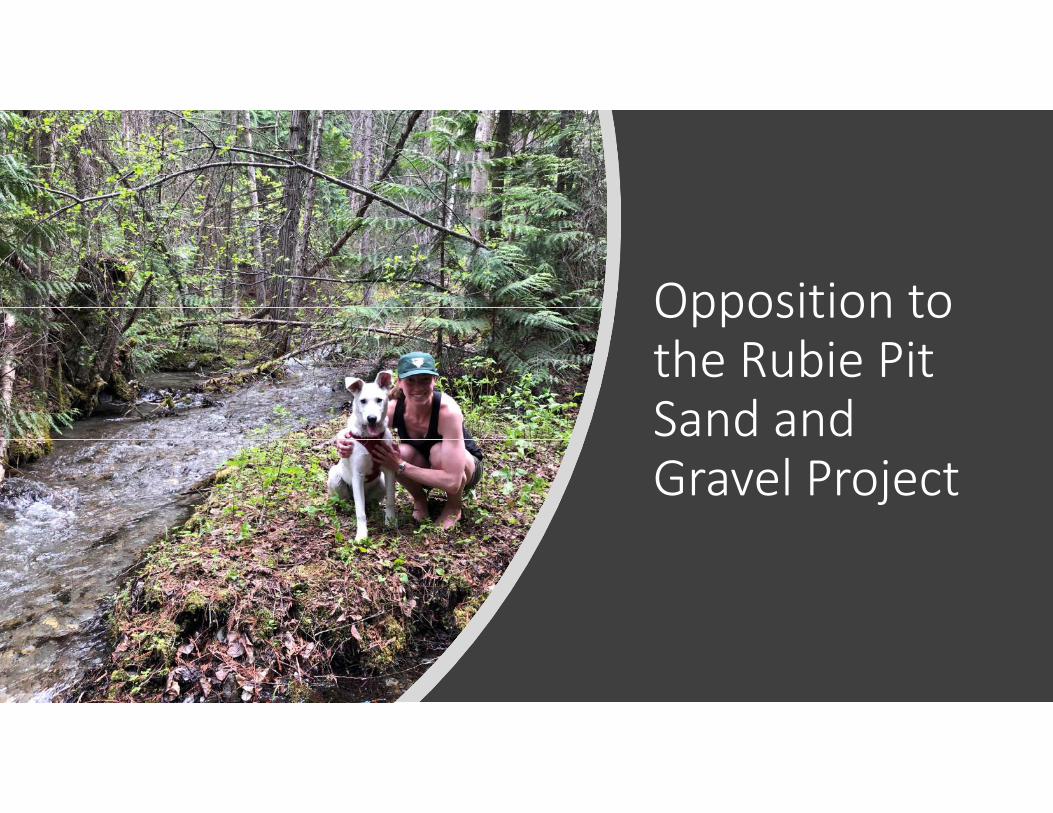
Opposition to
the Rubie Pit
Sand and
Gravel Project

Who are we?
• Group of shared landowners dating back to the mid 1970’s
• Three generations of friends and family have been lucky enough to share this land
• We all care deeply about our property, the adjacent land and preserving the environment


- 9 private properties in the Valley
(with exception to some 50km
south near Canal Flats)

Overview of Location Compared to Our Property

Access Concerns

Application Status
• Lands – License of occupation – Agency review and FN consultation TBD;
• Mines permit – Public consultation imminent;
• License to cut – unknown
• License for water – Rubie creek - unknown

Lands - Public Notice and Application Review
• Public Notification process was inadequate:• No consultation with adjacent landowners;• No notification at site of development; • Inadequate advertisements;
• Significant omissions in the application:• Application lacks general awareness of proximity to adjacent landowners;• Applicant failed to identify a well on our property within 300m of the site;• Applicant is unclear in duration of development, reclamation and future plans;• Application doesn’t identify that there will be visual impacts to adjacent land owners
or users (see 4.1.5 application);• Application doesn’t identify impacts to our ability to safely access our property (see
5.2.1 application);• Application fails to identify changes to drainage and increased erosion or
sedimentation (see 4.3.1 and 4.4.1 of application)

What we want?
• We are requesting the agency (RDEK) to recommend to the ministry the application be rejected and the applicant find a more suitable location for development.

Thank you for
your time!
• Special thanks to Gerry Wilkie,
Susan Clovechok and Doug Clovechok who visited the
proposed site during the Christmas break!
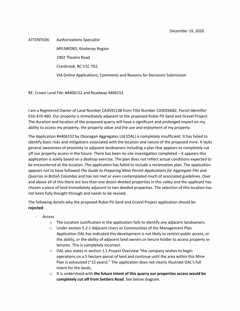
December 19, 2020
ATTENTION: Authorizations Specialist
MFLNRORD, Kootenay Region
1902 Theatre Road
Cranbrook, BC V1C 7G1
VIA Online Applications, Comments and Reasons for Decisions Submission
RE: Crown Land File: #4406152 and Roadway 4406153
I am a Registered Owner of Land Number CA3591138 from Title Number CA3026682, Parcel Identifier
016-470-460. Our property is immediately adjacent to the proposed Rubie Pit Sand and Gravel Project.
The duration and location of the proposed quarry will have a significant and prolonged impact on my
ability to access my property, the property value and the use and enjoyment of my property.
The Application #4406152 by Okanagan Aggregates Ltd (OAL) is completely insufficient. It has failed to
identify basic risks and mitigations associated with the location and nature of the proposed mine. It lacks
general awareness of proximity to adjacent landowners including a plan that appears to completely cut
off our property access in the future. There has been no site investigation completed – it appears this
application is solely based on a desktop exercise. The plan does not reflect actual conditions expected to
be encountered at the location. The application has failed to include a reclamation plan. The application
appears not to have followed The Guide to Preparing Mine Permit Applications for Aggregate Pits and
Quarries in British Columbia and has not met or even contemplated much of associated guidelines. Over
and above all of this there are less than one dozen deeded properties in this valley and the applicant has
chosen a piece of land immediately adjacent to two deeded properties. The selection of this location has
not been fully thought through and needs to be revised.
The following details why the proposed Rubie Pit Sand and Gravel Project application should be
rejected:
- Access
o The Location Justification in the application fails to identify any adjacent landowners.
o Under section 5.2.1 Adjacent Users or Communities of the Management Plan
Application OAL has indicated this development is not likely to restrict public access, or
the ability, or the ability of adjacent land owners or tenure holder to access property or
tenures. This is completely incorrect.
o OAL also states in section 1.1 Project Overview “the company wishes to begin
operations on a 5 hectare parcel of land and continue until the area within this Mine
Plan is exhausted (~15 years).” The application does not clearly illustrate OAL’s full
intent for the lands;
o It is understood with the future intent of this quarry our properties access would be
completely cut off from Settlers Road. See below diagram.

o In addition to physical access to the property this quarry proposal likely also prevents
the ability to install utilities to into the property should they become available in the
future (such as gas, electricity, etc).
o How will the applicant ensure safe and secure access during and after operations?
- Geotechnical and slope stability concerns
o The proposed location of the quarry is adjacent to my property along an existing steep
embankment. The removal of materials in this location can cause slumping or failure of
this slope and damages and a reduction of value of my property.
o There are no details in the application regarding the requirements of reclamation. In
fact, it appears the application has not even identified this as a risk or completed any
preliminary engineering or investigations.
o How will the applicant ensure slope stability and preservation of our lands and lands
adjacent to us?
- Environmental
o OAL is proposing the removal of water from Rubie creek @ 2000 gallons per day. Rubie
creek is a very small creek and fluctuates with seasonal flows. This may have a large
impact on the riparian areas and the creek bed.
o Within section 4.1.3 Riparian Encroachment OAL has indicated there will be no impact
to riparian zone of any water body. I believe this is incorrect considering the dewatering
contemplated in this proposal.

o Noise and dust associated with quarry and aggregate production will have an adverse
impact on the environment and can potentially impact our health.
o The application has not included any details regarding water management within the
site.
o It appears the applicant has failed to identify any environmental risks associated with
this development with exception to the potential to have archeological findings.
- Ground Water
o The application has failed to identify risks associated with impacting ground water and
therefore have no mitigation in place.
o The application fails to identify a well within 300m of the proposed site.
o The application fails to identify Anderson spring within close proximity of the proposed
site.
o The application lacks any water management plan for the site. It does not include or
contemplated any erosion or sediment control measures.
- Noise and Dust
o The applicant has failed to even identify noise and dust in their planning.
o Our property, located directly adjacent to this proposed quarry will be significantly
impacted for an extended duration of approx. 15 years. Noise pollution will significantly
impact our quality of life on our property and will also impact wildlife. An active quarry
adjacent to our property will decrease our property value.
o Many studies have shown dust produced from quarries contains silica. Inhaling
crystalline silica can lead to serious, sometimes fatal illnesses including silicosis, lung
cancer, tuberculosis (in those with silicosis), and chronic obstructive
pulmonary disease (COPD). The proximity of the quarry to our lands increases our
exposure to silica.
o How does the contractor intend on managing dust and noise? Will there be active
sound, vibration and air quality monitoring with available data through the life of the
quarry?
- Public Notice
o The requirements of section 4.6 Notification Requirements of The Guide to Preparing
Mine Permit Applications for Aggregate Pits and Quarries in British Columbia have not
been met.
o While the 30 day comment period was met (within The Columbia Valley Pioneer –
printed in the Nov 19 and Nov 26 issues), the project application could not be found in
the BC Gazette, as is required for gravel pit applications.
o Further to this, The Columbia Valley Pioneer was the only publication within which
public notice could be found. The Guide to Preparing Mine Permit Applications for
Aggregate Pits and Quarries in BC states “public consultation should take a variety of
forms”.
o In accordance with section 4.6 Notification Requirements of The Guide to Preparing
Mine Permit Applications for Aggregate Pits and Quarries in British Columbia “Proactive
consultation with…. Locally affected communities or landowners will assist in identifying
and addressing potential concerns related to a proposed mine”. As an affected
landowner this consultation has not happened.

o The Public Notice requirements have not been met.
- Vandalism, Damage to Lands and Trespassing
o The development of an open mine pit will increase the chances of persons accessing,
dumping garbage and debris and damage my land and the lands adjacent.
o How will this risk be mitigated and my land be protected?
- Loss of Property Value
o The development proposed will significantly decrease our property values. Should the
application be approved, who will pay this compensation?
- Discrepancies in the Application
o The Site Plan view shows sections A, B and C, however these sections are not included in
the information provided. This information is necessary to fully assess the impact of the
proposed works.
o The Site Plan states “Proposed Works – Y5 (2020-2025)” however within the
Management Plan application it is stated “In 2021, the company wishes to begin
operations on a 5 hectare parcel of land and continue until the area within this Mine
Plan is exhausted (~15 years).” The duration discrepancy is significant. The duration and
plan is not clear.
o Crown Land File #4406152 indicates area size of 3.81ha. OAL states in application they
will begin operations on a 5ha parcel of land (section 1.1).
- Insufficient Permit Application
o The Guide to Preparing Mine Permit Applications for Aggregate Pits and Quarries in
British Columbia outlines what the applicant should included within the application. The
application does not meet a significant amount of this guideline. The application lacks
detail and planning surrounding the proposed work. For clarity the requirements as
outlined in Section 5.6 of the Guide to Preparing Mine Permit Applications for Aggregate
Pits and Quarries in British Columbia are in Italic and my comments are in red.
Site Plan Requirements (General) Include documentation of the following:
• property boundaries
• access roads
• location of all structures and wells on neighboring properties within 300
metres of the property line – well within 300mm of proposed mine not
shown on plan. It appears to have not been identified.
• watercourses
• current land uses adjacent to property (e.g., forestry, residential, farms,
etc.) not shown. The applicant appears to have ignored neighbouring
property owners.
• elevation contours at five metres or less
b) Mine Plan (Specific) Include documentation of the following:
• final boundaries of excavation insufficient. Future mine plan
contemplated but not detailed
• buffer zones and setbacks
• area of initial excavation and progression of mining
• plan of progressive reclamation no reclamation details included
• final configuration after reclamation no reclamation details included
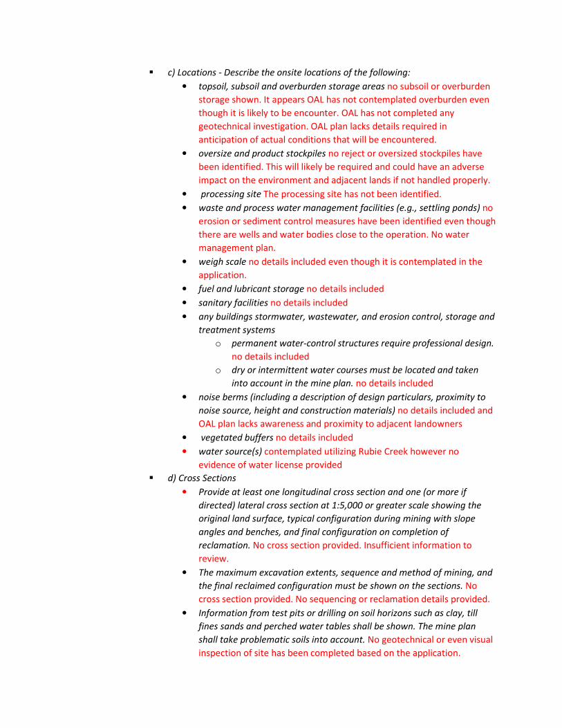
c) Locations - Describe the onsite locations of the following:
• topsoil, subsoil and overburden storage areas no subsoil or overburden
storage shown. It appears OAL has not contemplated overburden even
though it is likely to be encounter. OAL has not completed any
geotechnical investigation. OAL plan lacks details required in
anticipation of actual conditions that will be encountered.
• oversize and product stockpiles no reject or oversized stockpiles have
been identified. This will likely be required and could have an adverse
impact on the environment and adjacent lands if not handled properly.
• processing site The processing site has not been identified.
• waste and process water management facilities (e.g., settling ponds) no
erosion or sediment control measures have been identified even though
there are wells and water bodies close to the operation. No water
management plan.
• weigh scale no details included even though it is contemplated in the
application.
• fuel and lubricant storage no details included
• sanitary facilities no details included
• any buildings stormwater, wastewater, and erosion control, storage and
treatment systems
o permanent water-control structures require professional design.
no details included
o dry or intermittent water courses must be located and taken
into account in the mine plan. no details included
• noise berms (including a description of design particulars, proximity to
noise source, height and construction materials) no details included and
OAL plan lacks awareness and proximity to adjacent landowners
• vegetated buffers no details included
• water source(s) contemplated utilizing Rubie Creek however no
evidence of water license provided
d) Cross Sections
• Provide at least one longitudinal cross section and one (or more if
directed) lateral cross section at 1:5,000 or greater scale showing the
original land surface, typical configuration during mining with slope
angles and benches, and final configuration on completion of
reclamation. No cross section provided. Insufficient information to
review.
• The maximum excavation extents, sequence and method of mining, and
the final reclaimed configuration must be shown on the sections. No
cross section provided. No sequencing or reclamation details provided.
• Information from test pits or drilling on soil horizons such as clay, till
fines sands and perched water tables shall be shown. The mine plan
shall take problematic soils into account. No geotechnical or even visual
inspection of site has been completed based on the application.

Property Description
• Provide the following information about the mine property:
o address (if applicable)
o property owner’s name
o legal description
o size (in hectares)
• If directed, a legal survey of the mine property may be required.
f) Material Quality and Quantity
• Describe the type and volume of material to be excavated, and how
volume estimates were arrived upon. No details on how the estimated
volumes were calculated and no geotechnical information to support
estimate.
g) Mining Method Include documentation of the following:
• A development schedule which shows how and what method will be
used to remove overburden (i.e., type of equipment, such as loader or
excavator, to be used) this detail has not been provided.
• Configuration of the pit (e.g., pit slope angle, mining face height and
angle, bench spacing and width, etc.)
o Should be shown in the mine plan and sections This information
has not been included. No sections shown. Appears the OAL has
not provided sufficient details to ensure slope stability during
and after operations.
• Haul roads
o Provide the methods to be followed in the construction of
haulage roads. Design parameters of the pit haul roads in terms
of gradient, stabilized running surface, height of shoulder barrier
• Traffic plan
o Provide a traffic control plan showing the maximum allowable
speeds for the vehicles in use, rules for passing, “stop” and
“yield” locations, priority rules for various vehicles, rules for
night operation, maximum operating grades, emergency run-off
protection, shoulder barriers, and any other information
required by MEMPR.
• Open pit design
o Preliminary pit slope designs are required for initial permitting
based on available information obtained from boreholes, test
pits, and nearby rock cuts or natural outcrops. No geotechnical
investigation completed. No slope designs completed.
o Pit slopes are required for phased pit expansions using the
detailed geology and geotechnical information obtained from
exposed pit slopes, additional geotechnical boreholes, and
experience with the interim walls. Insufficient information. No
site investigation has been completed in order to plan for actual
conditions expected to be encountered.

h) Processing
• Include a description of the products expected to be produced, the
proposed method of processing (e.g., crushing, screening, washing, etc),
and proposed types of equipment that are to be used. OAL indicates
they intend to produce materials for future use. No details have been
included regarding the gradation of materials desired to be produced.
No evidence the raw materials will be sufficient to produce the
manufactured product. No indication of waste by-product or required
import of blending product. There are no details regarding method of
crushing and whether washing of products will be required in which
would require additional environmental protections not contemplated
in application.
• Indicate if processing will be continuous with respect to excavation or in
batches from time to time.
• If batch processing, indicate if processing equipment will be left on site
between batches. No details included.
• Note that all machinery must comply with the HSRC, but trucks used
only to haul product from the site are not considered to be mining
equipment and are not subject to the equipment standards provisions of
the Mines Act and HSRC.
i) Soil Salvage and Stockpiles
• Identify any soil storage locations, configurations, and anticipated
volumes. No subsoil or overburden stockpiles or quantities
contemplated even though they are likely to be encountered in this
area.
• Soil salvage, storage and replacement should be based on information
collected, including descriptions of soils, depth to be salvaged, erosion
and sediment control, and anticipated volumes of each soil type.
Insufficient information included. OAL’s plan lacks the detail required to
ensure soils will be salvaged properly and reclamed. No erosion and
sediment control details have been accounted for or included.
• Soil compaction and other activities that destroy soil structure should be
avoided.
j) Additional Mine Site Infrastructure
• Any additional mine site structures, including on-site accommodations
and offices, must be described in terms of location and construction.
Items of particular relevance to the reclamation plan are locations,
foundations, and nature of construction (e.g., movable modular units or
“permanent” structures).
k) Noise Impacts
• Describe the potential noise impacts of the operation and what
measures are proposed to minimize these impacts. OAL’s application
does not include any evaluation of impacts or mitigations associated

with their operations regarding noise even though the contemplated
mine site is adjacent to landowners.
• For quarries, describe the type of drills, blast pattern and frequency, and
measures to mitigate blast effects.
• A notification plan for neighbours living within a specific radius from the
quarry may be required. No notification has been made.
l) Dust Impacts
• Describe the potential impacts of dust generated on the sites, especially
potential impacts on adjacent properties, and describe what measures
are proposed to minimize dust impacts. OAL’s application does not
address any mitigations with regards to dust. The operation will
produce significant dust which is likely to include silica, which can have
long term and adverse health impacts. OAL has failed to recognize this
hazard to adjacent properties, wildlife, public and landowners.
m) Geotechnical Considerations
• British Columbia’s predominantly mountainous terrain has historically
resulted in pit and quarry operators tending to work from the most
easily accessible portion of the deposit, usually the toe of a slope. This
practice can sometimes lead to future negative events, including
geotechnical failure, with considerable future mitigation and expenses
required. The application lacks any design, reclamation details or
foresight regarding the future state of the lands and the potential
impacts to adjacent properties and potential safety and environmental
hazards associated with their proposal.
• APPENDIX 3 provides guidance on the development of mine plans for
different types of terrain.
n) Groundwater Impacts
• Information will be required to demonstrate the proximity of the
proposed excavation to the water table. No site investigation has been
completed and the water table level is unknown. The impacts to the
groundwater have not been considered and this mine could impact
adjacent wells.
• The operator must be aware of the possibility of perched water tables
bounded by hard till or clay/silt layers. No site investigation completely.
Perched water tables have not been identified in the application.
• The inspector may require a professional estimate of the winter high
water table if the excavation is likely to approach that level.
• Excavations below the water table will require special approval.
o) Groundwater Mitigation and Control
• Describe potential impacts of the proposed operation on groundwater
quantity and quality. The application contains insufficient information
and lacks any mitigation associated with impacting groundwater. Close
proximity wells have not been identified.

• If there are nearby wells or down slope water users, a hydrogeological
study to assess potential impacts and recommend mitigative measures
will be required. It appears the applicant is unaware of adjacent wells.
• Depending on known soil types and/or terrain, a slope stability analysis,
which will be used in the mine plan to mitigate groundwater and surface
water effects on slope stability, may be required.
p) Surface Water Management
• List the number of settling ponds and a provide description of the water
source, proposed dimensions and construction methods for each pond.
No site water management plan has been contemplated. No temporary
erosion and sediment control has been contemplated. No details
regarding reclamation have been included.
• If constructing a dam or dyke, indicate what the height of the dam or
dyke wall will be, and what materials will be used for construction.
• Indicate whether or not water will exfiltrate into the ground or will be
decanted to a watercourse. Describe the decant structure if one is
required. Application has not contemplated any site water management
plan.
• Describe how extreme rainfall events will be managed. This has not
been addressed.
q) Erosion Control and Sediment Retention Plan
• Describe how erosion will be prevented/minimized during construction
and throughout the mine life, and how any detached sediment release
will be contained within the mine site. No erosion and sediment control
plan has been identified.
• A potential for erosion will result from surface disturbance and exposure
during development activities. The proponent should be adequately
prepared to respond both with knowledge and materials (e.g., seed,
fertilizer, silt fences, settling ponds, flocculants). No erosion and
sediment control plan has been identified.
• Erosion control/sediment removal plans are required for disturbed
surfaces and soil stockpiles. No erosion and sediment control plan has
been identified.
o List the equipment that will be used for pond cleaning.
o The ground must be stable enough for the proposed works.
o A report on the structural stability of an existing pond may be
required.
o New impoundment structures may require a design from an
appropriate qualified professional.
r) Metal Leaching and Acid Rock Drainage (ML/ARD)
• Hard-rock quarry applications must include a ML/ARD geochemical
prediction of all materials exposed, disturbed or created during mining,
in accordance with the “Policy for Metal Leaching and Acid Rock
Drainage at British Columbia Mine Sites” (BCMEM and BCMELP, 1998)

and the “Guidelines for Metal Leaching and Acid Rock Drainage at Mine
sites in British Columbia” (Price and Errington, 1998).
s) Reclamation Cost Estimates and End Land Use
• Describe the intended land use of the mine site upon completion of
mining. Proponents should be aware of the local land use zoning for the
area and whether or not the intended end land use is consistent with the
zoning. No reclamation plan has been included. The application is
insufficient.
• A reclamation cost estimate is required for all phases of mine
development and closure. These cost estimates form the basis of the
timing and size of securities required as a condition of the Mines Act
Permit. Not included.
• Reclamation cost projections must normally include, but are not
necessarily limited to, the following: Not included.
o site preparation
o revegatation and fertilization
o disposal of structures and equipment
o construction of spillways, diversions and other water
management structures
o removal of culverts
o disposal of fuel, contaminated soils, and toxic materials
o long-term maintenance and monitoring programs
o mobilization and demobilization
o engineering re-design costs
- Future Work
o Throughout the application future work is discussed however the full intent is vague and
unclear. The plan has not been thoroughly developed and has not contemplated
impacts to adjacent landowners.
- Visual Impacts
o OAL answered “no” to section 4.1.5 Visual Impacts. There will be adverse effects of the
project, and potential adverse effects on sight lines to the project area from surrounding
areas likely to be used for scenic viewing by residents or other users. This project will
impact our enjoyment and site lines from our property.
- Archeological Sites
o OAL has stated in the application a potential for significant archeological finds and has
also indicated that multiple archeological sites exist within a 6km radius. It appears this
is based on a desktop exercise. Based on this information, provided to OAL by a local
reputable archeological company, a site investigation should be completed before the
application is approved.
Based on the significant and real issues outlined in my letter, the complete lack of general awareness of
location and proximity to adjacent landowners and the lack of information to support the application,
consideration for approval of the application should be denied.

The proposed works would have significant impact to my property, health and quality of life.
Please contact me should you have any questions or concerns. I expect a detailed response in due time.
Regards,
Bryce Terry, P. Eng
Personal information has been withheld in accordance with section 22(1) of the Freedom of Information and Protection of Privacy Act.