Asteroid Observations - Real Time Operational Intelligence Series

WEATHER RESPONSE SYSTEM
OPERATIONAL OBSERVATIONS REPORT
August 2006
Weather Response System Operational Observations Report
Table of Contents
1 INTRODUCTION..................................................................................................... 1
1.1 Purpose............................................................................................................................................ 1
1.2 Definitions, Acronyms, and Abbreviations .................................................................................. 1
1.3 References ....................................................................................................................................... 1
2 BACKGROUND ....................................................................................................... 2
2.1 History of Project ........................................................................................................................... 2
2.2 Approach......................................................................................................................................... 4
2.3 Objectives and Scope ..................................................................................................................... 5
2.4 Operational Policies and Constraints ........................................................................................... 6
2.5 Description of Normal Modes of Operation for Weather Information ..................................... 7
2.6 User Classes and Other Involved Personnel ................................................................................ 8
2.7 Support Environment .................................................................................................................... 9
3 WRS DEPLOYMENT AND ENHANCEMENTS............................................... 10
3.1 Initial Deployment........................................................................................................................ 10 3.1.1 WRS Home Page....................................................................................................................... 10 3.1.2 National Weather Maps Module................................................................................................ 10 3.1.3 Statewide Weather Maps Module.............................................................................................. 12 3.1.4 Regional Weather Maps Module............................................................................................... 12 3.1.5 Slideshow Module..................................................................................................................... 13 3.1.6 Maintenance Planner Module.................................................................................................... 15
3.2 Enhancements............................................................................................................................... 16 3.2.1 Federal Highway Administration Review ................................................................................. 16
3.2.1.1 Changes to WRS Frame and Main Navigation Tools ...................................................... 16 3.2.1.2 Created New Home Page ................................................................................................. 17 3.2.1.3 Created a New Graph Module ......................................................................................... 17 3.2.1.4 Changes to the Planner Module ....................................................................................... 18
3.2.2 Missouri Department of Transportation Training...................................................................... 19 3.2.2.1 Added Email Links .......................................................................................................... 19 3.2.2.2 Added a Radar Module .................................................................................................... 19 3.2.2.3 Changes made to the MapShow Module ......................................................................... 21
3.2.3 Presentations to NOAA and MoDOT Personnel ....................................................................... 22 3.2.3.1 Changes to WRS Navigation and Overall Presentation ................................................... 22 3.2.3.2 Add a Larger Map View to the Planner Module.............................................................. 23
4 EVALUATION AND RECOMMENDATIONS.................................................. 25

Weather Response System Operational Observations Report
4.1 Introduction.................................................................................................................................. 25
4.2 Available Tools in WRS by Organizational Areas of Responsibility....................................... 26 4.2.1 Transportation Management Centers......................................................................................... 26 4.2.2 Traffic Operations ..................................................................................................................... 26 4.2.3 Maintenance Operations............................................................................................................ 27 4.2.4 Construction Operations............................................................................................................ 28 4.2.5 Customer Service ...................................................................................................................... 28
4.3 Recommended Enhancements to the Prototype WRS .............................................................. 29 4.3.1 Use of Markers on Expanded Google Maps.............................................................................. 29 4.3.2 Maintain the Selected Map View in the Planner ....................................................................... 29 4.3.3 Provide a Regional Kansas City Map View .............................................................................. 29 4.3.4 Display Default Maps for Each Tab .......................................................................................... 30 4.3.5 Provide Forecast Pop-Ups ......................................................................................................... 30 4.3.6 Provide Ability to Email or Page a Forecast ............................................................................. 30 4.3.7 Provide Email and Pager Alerts ................................................................................................ 30 4.3.8 Provide long-range general forecasts ........................................................................................ 30 4.3.9 Provide longer forecast periods in MapShow............................................................................ 31 4.3.10 Provide storm tracking capability ......................................................................................... 31 4.3.11 Provide information on type of precipitation........................................................................ 31 4.3.12 Provide information on precipitation rates ........................................................................... 31 4.3.13 Provide probability of hail .................................................................................................... 32 4.3.14 Provide lightning information............................................................................................... 32 4.3.15 Provide additional dew-point and humidity information...................................................... 32 4.3.16 Provide frost information...................................................................................................... 32 4.3.17 Provide pavement temperatures............................................................................................ 32 4.3.18 Provide river cresting information........................................................................................ 33 4.3.19 Provide ozone information ................................................................................................... 33 4.3.20 Provide customizable displays.............................................................................................. 33
4.4 Conclusions ................................................................................................................................... 33
4.5 Contractor Recommendations .................................................................................................... 34
APPENDIX A - DEFINITIONS, ACRONYMS, AND ABBREVIATIONS .......... 36
Table of Figures FIGURE 1 – INITIAL WRS HOME PAGE ................................................................................................ 10 FIGURE 2 – INITIAL NATIONAL WEATHER MAPS PAGE................................................................. 11 FIGURE 3 – INITIAL STATEWIDE WEATHER MAPS MODULE ........................................................ 12 FIGURE 4 – INITIAL REGIONAL WEATHER MAPS MODULE........................................................... 13 FIGURE 5 – INITIAL SLIDESHOW SETTINGS INTERFACE................................................................ 14 FIGURE 6 – VIEW FROM INITIAL SLIDESHOW PRESENTATION.................................................... 14 FIGURE 7 – INITIAL MAINTENANCE PLANNER MODULE............................................................... 15 FIGURE 8 – CHANGES TO WRS FRAME AND NAVIGATION TOOLBAR........................................ 17 FIGURE 9 – NEW WRS HOME PAGE...................................................................................................... 17 FIGURE 10 – POPULATED GRAPH MODULE....................................................................................... 18 FIGURE 11 – CHANGES TO THE PLANNER MODULE........................................................................ 19 FIGURE 12 – RADAR MODULE HOME PAGE....................................................................................... 20 FIGURE 13 – RADAR MODULE DISPLAY PAGE.................................................................................. 20 FIGURE 14 – “CLEAR VALUES” BUTTON IN MAPSHOW.................................................................. 21 FIGURE 15 – EXAMPLE OF AN UPDATED MAPSHOW PRESENTATION PAGE ............................ 22 FIGURE 16 – WRS PRESENTATION AND NAVIGATION.................................................................... 23

Weather Response System Operational Observations Report
FIGURE 17 – WRS 600 X 800 SCREEN VIEWS ...................................................................................... 23 FIGURE 18 – “VIEW LARGE MAP” BUTTON AND POP-UP MAP...................................................... 24
Revision History
Revision Issue Date Status Authority Comments
001 May 2006 Draft CJH
002 June 2006 Draft BCB
003 August 2006 Final BCB
Electronic File Saved As: 04018op401rpt0400.doc

Weather Response System Operational Observations Report
1 INTRODUCTION
1.1 Purpose This document summarizes the background, development, and assessment of the prototype development phase of the Weather Response System (WRS). The document describes:
• The objectives and background to the development of the prototype WRS;
• The evolution of the prototype WRS, including changes that were made to the system as a result of use and/or reviews by Missouri Department of Transportation (MoDOT), Federal Highway Administration (FHWA), and National Weather Service (NWS) personnel; and
• The results of an operational assessment exercise conducted with MoDOT and FHWA personnel.
The operational assessment exercise identified suggested changes and enhancements that could be made to the prototype WRS to increase its value as a traffic operations, maintenance operations, construction operations, and customer service tool. These recommendations could serve as the basis of a further design and development phase to the WRS.
1.2 Definitions, Acronyms, and Abbreviations This document may contain terms, acronyms, and abbreviations that are unfamiliar to the reader. A dictionary of these terms, acronyms, and abbreviations can be found in Appendix A.
1.3 References 1. “Missouri Weather Response System, Concept of Operations,”
Mixon/Hill, Inc., November 2004.
2. “Missouri Weather Response System, System Architectural Description,” Mixon/Hill, Inc., December 2004.
3. “Missouri Weather Response System, System Requirements Specification,” Mixon/Hill, Inc.

Weather Response System Operational Observations Report
2 BACKGROUND
2.1 History of Project The purpose of this project is to develop a WRS and assess the operational use of weather information for transportation management, operations, and maintenance.
Funding for the WRS development is provided by the U.S. Department of Transportation's FHWA and MoDOT through a Cooperative Agreement, DTFH61-04-H-00017. MoDOT contracted with Mixon/Hill, Inc. to lead the development of the WRS.
Transportation system operations are very sensitive to weather conditions. However, weather information and information about the impact of weather on the transportation system is currently not well integrated into the operational framework of most state transportation agencies. Today, operations personnel in many state departments of transportation obtain weather information from multiple sources (e.g., NWS, newspaper, local television stations, commercial weather firms, etc.), and, in many cases, this information is non-specific, conflicting, and not tailored to support the needs of the specific decision makers.
The establishment of the FHWA Road Weather Management program within the Office of Transportation Operations signaled that weather has an important impact on operations and that weather and road condition information need to be integrated into operations.
The FHWA, working with state transportation agencies, national laboratories, the National Oceanic and Atmospheric Administration (NOAA), the American Meteorological Society (AMS), the Aurora Program, and others, has raised the awareness of the needs of the surface transportation community for better, more tailored weather and road condition information. The FHWA winter Maintenance Decision Support System (MDSS) project is a good example of a project that has brought stakeholders together to develop advanced road-weather applications tailored for end users. The MDSS project utilized currently available weather data sources and developed advanced capabilities where no off-the-shelf solutions existed. Through an iterative process of development and user feedback, the MDSS prototype successfully evolved into an effective decision support system. State transportation agencies and the private sector are using the MDSS prototype as a template for an operational capability in winter weather maintenance.
The WRS similarly brings together advanced weather and road condition technologies for addressing other operational categories, including traffic, incident, and emergency management, and for broader maintenance activities, beyond winter storm response.
Overall, the development of WRS is an iterative process that has begun with the development, implementation, and demonstration of a prototype WRS. The development of the prototype WRS and the recommendations that have emerged for future system enhancements are described in this report. Future activities could include further development and demonstration of the concepts and

Weather Response System Operational Observations Report
components of the prototype WRS; the development of enhanced decision support tools; and the deeper integration of WRS into the maintenance and operations activities of a state transportation agency.
For this project, user-tailored data and products generated by the WRS were provided to MoDOT personnel, allowing them to respond to the effects of changing weather in a proactive manner. The overall scope encompassed transportation system operations, maintenance strategies, and weather information for customers.
Thinking of MoDOT’s operational weather information needs, it is easy to focus on severe winter weather and winter storms. The needs at those times, such as deploying plows and choosing the appropriate roadway treatments, are very visible and are understood by the public and practitioners alike.
However, weather information is an operational priority for MoDOT throughout the year. Many of the warm-weather operations that MoDOT performs are also weather sensitive. For example, pavement striping, work zones, emergency repairs, and mowing and brush cutting are all affected by heavy rains, lightning, tornados, strong winds, and extreme temperatures. Consequently, the prototype WRS was intended to support MoDOT’s operational needs year round.
MoDOT operates as a decentralized organization with its Central Office located in Jefferson City, Missouri. Major divisions within MoDOT include Administration, Communications, Finance, Operations, Planning, and Project Management. Central Office and district offices operate under similar organizational structures with Central Office providing staff assistance and functional integration for various departmental tasks in the 10 geographical districts. Each district contains about 10 percent of the total road mileage in the state highway system and is under the direction of a District Engineer who is responsible for administering all Department activities in his/her respective district.
MoDOT currently has three operational Transportation Management Centers (TMCs): the St. Louis Gateway Guide Transportation Information Center (TIC), KC Scout Transportation Operations Center (TOC), and Springfield’s Ozarks Traffic Information. These TMCs monitor metro-area highways using a range of advanced technologies to provide motorists with real time traffic information and facilitate incident response.
Information on forecast weather and road conditions is an operational priority for MoDOT throughout the year. For example, MoDOT factors weather information into decisions affecting:
• Transportation Management Centers;
• Traffic operations;
• Maintenance operations;
• Construction operations;
• Public information/customer service.
Weather Response System Operational Observations Report
However, MoDOT does not currently have a comprehensive source of weather forecast or road condition information on which to base these decisions. Instead, MoDOT utilizes a small network of 13 Road Weather Information System (RWIS) sites around the state, together with a variety of weather information sources including commercial media, Data Transmission Network (DTN) weather radar, the Internet, and intra-agency radio and telephone communications to gather information1. Furthermore, weather and road condition information is not currently tailored to meet the individual needs of MoDOT users; nor is it tightly integrated into existing systems used by MoDOT personnel. Indeed, even the most intensive use of weather and road condition information for winter weather maintenance relies heavily on individual experience and established rules of practice rather than automated systems.
2.2 Approach The prototype WRS was developed using a systems engineering approach for rapid prototyping. Prototyping is the process of building a working model of a system, for the purpose of evaluating potential functions of the final system and refining its design.
User requirements workshops were held with stakeholders from FHWA and the Traffic Division in the MoDOT Central Office and employees in Districts 4 and 9 of MoDOT. These workshops discussed the forecasted weather information needed to plan and schedule work, and the real-time weather information needed to perform work. Divisions represented in the requirements gathering meetings were maintenance, construction, bridge, traffic, and representatives of the transportation management center (TMC). In breakout sessions, each of the activities performed by MoDOT personnel were evaluated for relevance to the objectives of the WRS project. The various MoDOT work activities were discussed in terms of a pre-defined set of weather parameter to determine the impact of that weather element on the work task.
Telephone interviews were held with the MoDOT districts to ascertain the current status of all environmental sensor stations (ESS) within the MoDOT Road Weather Information System (RWIS).
A Concept of Operations (ConOps) was created to articulate the needs of MoDOT weather and road condition information users. The ConOps described how the prototype WRS would be developed and operated to satisfy those needs. The user needs were supplemented through literature reviews and individual interviews with MoDOT personnel, in addition to the user requirements workshops described above.
A System Architectural Description (SysAd) was created to describe the system components and their relationship to one another for the prototype WRS. The architecture of the system was described from multiple viewpoints to capture various stakeholder perspectives. These base system architectural viewpoints are
1 Cambridge Systematics, Inc., Road Weather Information System Statewide Plan, Draft ConOps, Prepared for the Missouri Department of Transportation, May 2004.

Weather Response System Operational Observations Report
followed by a description of how the prototype WRS fits within the National ITS Architecture and Missouri’s regional architectures.
An internal Systems Requirements Specification (SRS) was created to provide a repository for the requirements governing the design of the prototype WRS. These requirements formed the basis for the design verification and validation of the system.
Following these documents, the prototype WRS was designed and created. Because this project was based on rapid prototyping, a formal design document was not created. However, a copy of the code was archived at any point that major changes to the code occurred. During the rapid prototyping period, FHWA and MoDOT evaluated the current state of the system and made recommendations for change. Based on scope, schedule, and budget, the changes were either implemented in the system at that time, or were recommended as future enhancements.
During the latter phases of the development of the prototype WRS, the system was evaluated by FHWA. FHWA provided recommendations for enhancements, all of which were incorporated prior to deployment of the prototype WRS by MoDOT in District 4.
An operator user guide was created that provided a description of the WRS applications, along with step-by-step instructions to use the prototype WRS. A training session was held with MoDOT employees to instruct them on the operational use of the prototype WRS and appropriate applications of the system. During the training session, several recommendations for enhancements were submitted by MoDOT personnel. All recommendations submitted during the training session were incorporated into the prototype WRS and deployed.
During the evaluation period, conference calls and one-on-one meetings were held with selected operators of the prototype WRS. All recommendations submitted during these calls and meetings were incorporated into the prototype WRS and deployed.
Extremely mild winter and spring weather was experienced throughout the prototype evaluation, and regrettably the system could not be exercised to its full potential. As a result, an additional meeting was held with MoDOT stakeholders to evaluate the prototype WRS using both newly-established scenarios and actual prior weather events. The stakeholders, representing urban and rural locations within District 4, included three employees from the TMC (supervisors and operators), three employees from traffic (administration, striping, and signs), four employees from construction (inspector, resident engineers, and district construction engineer), and twelve employees from maintenance (district maintenance engineer, maintenance superintendents, and supervisors). This report documents the results of this evaluation, including recommendations submitted for future enhancements.
2.3 Objectives and Scope The prototype WRS has been developed and implemented to:

Weather Response System Operational Observations Report
• Aid in the evaluation and assessment using weather information for surface transportation system management, operations, and maintenance objectives; and
• Support effective response by MoDOT personnel to the impacts of weather on the transportation system.
The prototype WRS is designed to:
• Take advantage of operational weather data and products from the NWS;
• Utilize a variety of weather data sources including traditional NWS sources and emerging products such as the NWS National Digital Forecast Database (NDFD);
• Leverage the experiences related to user needs and decision support tools developed in the FHWA MDSS project;
• Provide a framework to develop and demonstrate prototype road-weather products tailored for specific operational categories (e.g., traffic management, maintenance management, and customer service);
• Support the operational decisions of maintenance supervisors and traffic managers in MoDOT; and
• Provide weather data managed by the WRS to TMCs and district maintenance facilities in order to evaluate its effectiveness and to identify the needs for additional weather-related decision support tools for transportation management, operations, and maintenance.
2.4 Operational Policies and Constraints There are no formal operational policies and procedures that relate to the use of weather information within the traffic management and traffic operations responsibilities of KC Scout. However, if a major weather event (such as a large winter storm) is anticipated in the Kansas City region, MoDOT will prepare for the event by extending shifts within the KC Scout TMC or calling in additional traffic operations and customer service personnel to handle expected workload. This process is somewhat informal and relies on the availability, accuracy, and timeliness of meteorological weather information from principally non-MoDOT sources.
The Maintenance Division of MoDOT provides its managers with “Maintenance Function Planning Guidelines.” These guidelines highlight the relationships between maintenance activities and weather and road conditions. For example, the guidelines identify maintenance activities that can be performed on rainy days and provide an overall monthly/seasonal maintenance work scheduling guide. Most importantly, however, the guidelines prescribe necessary weather and road conditions for each maintenance activity. For example, the guidelines specify that the “repair of full depth failures in Portland cement concrete pavement” should only be scheduled when the temperature is 50°F and above, and suggest that this limits the work to mid-March through the end of November.

Weather Response System Operational Observations Report
The maintenance guidelines specify work activities in the areas of:
• Pavement maintenance;
• Pavement preventative maintenance;
• Maintenance of shoulders and approaches;
• Drainage maintenance;
• Roadside vegetation and litter control;
• Maintenance of roadway safety devices;
• Maintenance of bridges;
• Bridge preventative maintenance; and
• Traffic operations (including marking, striping, and lighting repairs).
In addition, the MoDOT Maintenance Division provides its field personnel with an “Operators Guide for Anti-Icing.” This guide recommends maintenance actions for preventing the formation or development of packed and bonded snow or bonded ice on the first priority continuous treatment routes during a variety of winter weather events including:
• Light snow storms;
• Light snow storms with periods of moderate or heavy snow;
• Moderate or heavy snow storms;
• Frost or black ice;
• Freezing rain storms; and
• Sleet storms.
This guide describes the initial and subsequent maintenance operations activities for each winter weather event based on observations of pavement temperature ranges and trends.
The MoDOT Construction Division is also responsible for a variety of activities that are sensitive to weather and road conditions. However, unlike the activities of the Maintenance Division, these activities are conducted primarily by outside contractors. It is MoDOT’s policy to leave decisions relating to the scheduling and performance of the construction activities to these contractors.
2.5 Description of Normal Modes of Operation for Weather Information With no existing integrated statewide system for delivering weather and road condition information to the various MoDOT users, the multiple existing sources of information are used only in an advisory form as input to operational and short-term planning activities. Because information from the existing published sources may be incomplete or conflicting, individual users tend to rely on experience and established, but undocumented, rules of practice in their decision making.

Weather Response System Operational Observations Report
Depending on the direction of a weather event, districts may exchange information with each other on an informal basis.
Weather information is generally used reactively rather than proactively. Construction and maintenance crews report to job sites and assess the weather conditions upon arrival. If work can start, they start and continue work as long as weather conditions permit.
Long-term weather forecasts are considered too unreliable to be used for long-range maintenance and construction planning. In most cases, even seven day forecasts are considered too unreliable for use in short-term planning. The major exception is that seven day forecasts for ice or major snow storms will initiate maintenance preparations for the storm events. When 24-hour forecasts include snow and ice storms, work crews are put on notice and schedules are prepared for 24 hour operation for the snow/treatment crews.
At the TMCs, operations are relatively unaffected by weather. Snow crews may use TMC facilities and CCTV systems to monitor road conditions on the freeways, but the TMC websites do not publish weather or road condition information. TMC operations policies allow operators to post tornado warnings on DMS signs in counties that are under a warning, but there is no current procedure or mechanism for notifying the operators that such warnings are in effect. Operators are notified and can post warnings on the DMS signs when snow plowing operations are underway on the freeways.
Customer Service does not volunteer weather information to the traveling public, but will relay information from the DTN forecasts and MoDOT road condition website to customers when weather information is requested. Customer Service hours are extended to a 24/7 operation during major winter storms.
2.6 User Classes and Other Involved Personnel There are four primary existing weather and road condition information user classes within MoDOT:
• Maintenance operations personnel who use the various existing weather and road condition information sources in their year-round maintenance planning and winter weather response activities;
• Traffic operations personnel who utilize weather information in their real-time operational activities (for example, the KC Scout TMC displays the NWS at Pleasant Hill, MO on their consoles as needed during weather events);
• Customer Service personnel who use information from the MoDOT road condition information website to answer questions from the general public; and
• Construction operations personnel who have access to weather and road condition information but who utilize the information to the least extent. Since the Construction Division relies on contractors to perform much of its work, it is MoDOT’s policy not to interfere with their planning and

Weather Response System Operational Observations Report
scheduling activities. MoDOT construction personnel do not volunteer weather information to contractors; providing weather forecast informa-tion to contractors is considered a liability and MoDOT prefers that contractors obtain weather information directly from external weather information providers. MoDOT inspectors, within construction operations, use weather information to verify that contractors are performing their activities based on the published weather guidelines.
In addition to the internal MoDOT users, there are two other groups of involved personnel: the traveling public and commercial vehicle operators. These groups are indirect consumers of MoDOT weather data, receiving weather and road condition information from the MoDOT website, from Customer Service personnel who answer calls, and from the DMS signs when weather warnings are published.
Other agencies such as emergency services personnel, HAZMAT, Highway Patrol and local law enforcement do not consider MoDOT as a source for immediate or short-term weather information; they tend to ask their own dispatchers for weather information.
2.7 Support Environment MoDOT personnel receive support for all information technologies from the Information Systems Division.
DTN provides service and support for the equipment furnished as a part of its contract.
Most of the state’s RWIS installations were installed and maintained under a contract with SSI. The maintenance of the weather instrumentation is considered relatively low priority and is usually conducted on an annual basis rather than on a remedial basis. It can be weeks or months before a failed weather instrument is repaired or recalibrated.
Several of the state’s RWIS installations were installed by District offices for special purposes. The budgets and expertise for maintaining the weather instruments were rarely in place and, as a result, many of these installations have fallen into disrepair. The RWIS stations and the data received by MoDOT from those stations are not standardized, further complicating attempts to maintain the equipment.
Computers, software, network equipment, radio and satellite equipment, and video equipment installed in the TMCs are supported by local MoDOT District technicians or are supported under specific support contracts for each system where MoDOT lacks the staff or expertise to support the system internally.
The state currently has no trained meteorological staff to support forecasting, RWIS operations, or any other weather-related systems.

Weather Response System Operational Observations Report
3 WRS DEPLOYMENT AND ENHANCEMENTS
3.1 Initial Deployment This section describes the first development and deployment phase of the WRS prototype. This includes the initial system development work which took place prior to operational review by the potential users, and the preparation of the first draft of the Operator User’s Guide. Deployment of the initial WRS to MoDOT users occurred on December 22, 2005. The following sections describe the system as it was during this initial phase of development and deployment.
3.1.1 WRS Home Page During this phase, the National Maps Module, described below, was used on the WRS home page. The default page for WRS (called index.html) opens a frame within which is displayed, for the home page, the National Weather Maps module. The frame then remains in place for all subsequent selections by the users, with new modules opening within the frame. In the initial deployment, the home page shows five tabs, Regional, Statewide, National, SlideShow and Planner, which provide navigation to the five original modules. Figure 1 is a screen shot of the home page in the initial WRS deployment.
Main NavigationHelp Page Link
Navigation Tabs
Logos and Links
Figure 1 – Initial WRS Home Page
3.1.2 National Weather Maps Module The National Weather Maps module is the simplest of the modules and was the default module for the initial WRS deployment. This module consists of a single “Description” drop-down box. This box contains a list of national weather maps from which a selection can be made. The available weather maps allow for selection from the following:

Weather Response System Operational Observations Report
• National forecast (today); • Precipitation forecast (today); • Precipitation forecast (tomorrow); • Precipitation forecast (3-day); • 24-hour maximum temperature; • 24-minimum temperature; • 3-hour air temperature; • 3-hour dewpoint temperature; • 3-hour wind speed and direction; • 3-hour sky cover; • 3-hour weather conditions; • 12-hour probability of precipitation; • 6-hour precipitation amount; • 6-hour snow amount; • Current satellite visible; • Current satellite infrared; and • Current satellite water vapor.
In the National Weather Maps module, users do not select a geographic location because each map covers the entire continental United States. Figure 2 provides a screen shot of one selection from the National Weather Maps module in the initial WRS deployment.
Figure 2 – Initial National Weather Maps Page

Weather Response System Operational Observations Report
3.1.3 Statewide Weather Maps Module The Statewide Weather Maps module in the initial WRS deployment was designed to provide a view of individual states. The Statewide Weather Maps module provides similar weather map options to the National Weather Maps module, but, in addition, the user can select a “Primary State” from a second drop-down box. Figure 3 provides a screen shot of the Statewide Weather Map module used in the initial WRS deployment.
Figure 3 – Initial Statewide Weather Maps Module
3.1.4 Regional Weather Maps Module The Regional Weather Maps module provided a more detailed view of selected regions in and around the state of Missouri. The Regional Weather Maps cover a smaller geographic area than the Statewide Weather Maps, but show additional information such as county boundaries and principal cities. In common with the National and Statewide Weather Maps modules, the Regional Weather Maps module has a “Description” drop-down box from which the user can select appropriate types of weather map. This module also includes a “Primary Region” drop-down box, from which the user selects the region for which the weather map is displayed. Figure 4 is a screen shot of the Regional Weather Maps module in the initial WRS deployment.

Weather Response System Operational Observations Report
Figure 4 – Initial Regional Weather Maps Module
3.1.5 Slideshow Module In the initial WRS deployment, the Slideshow module allowed users to select the order in which specified types of weather information would be displayed. The Slideshow module was designed so that users could view a series of weather maps in the specified order, with each map being displayed for up to 60 seconds. The slideshow controls allowed the user to select from Regional, Statewide and National weather map views.
A user interface identifies each of the weather map levels (National, Statewide, and Regional) and for each level lists the specific weather maps available. Users can select any combination of views from the three map levels and available weather maps, and can define the order in which the views were presented and the duration of each view. These views are then presented in a continuous slideshow-style loop. The user interface also provides the ability to specify both a primary and optional location for the Regional and Statewide views. If both a primary location and an optional location are selected, the appropriate weather maps for both locations will be displayed to the user side-by-side in the slideshow. If no primary location is selected, the default location will be used in its place. Figure 5 provides a screen shot of the Slideshow Settings interface in the initial WRS deployment, while Figure 6 provides a screen shot of a single view from a Slideshow Presentation.

Weather Response System Operational Observations Report
Figure 5 – Initial SlideShow Settings Interface
Figure 6 – View from Initial Slideshow Presentation

Weather Response System Operational Observations Report
3.1.6 Maintenance Planner Module The Maintenance Planner in the initial WRS deployment allowed a user to select thresholds or ranges for various weather conditions, and to see the likelihood of these thresholds being met over the following six to seven days. The user could make selections from six different weather conditions:
• Temperature – minimum to maximum in degrees Fahrenheit;
• Humidity – minimum to maximum percentage of humidity;
• Sky cover – minimum to maximum percentage of sky cover;
• Chance of precipitation – minimum to maximum percentage chance of precipitation;
• Wind speed – minimum to maximum wind speed in miles per hour;
• Wind direction – direction of the prevailing wind.
Users can also select a location of interest by double clicking on a Google® map. Figure 7 provides a screen shot of the Maintenance Planner module in the initial WRS deployment.
Figure 7 – Initial Maintenance Planner Module

Weather Response System Operational Observations Report
3.2 Enhancements A series of modifications and enhancements were made to the initial WRS system deployment. These are described in the following sections.
3.2.1 Federal Highway Administration Review A review of the initial WRS was held with FHWA personnel on December 22, 2005. A number of potential enhancements to the initial system were identified, namely:
• Modify the frame that appears on each page of the WRS;
• Create a new home page for the WRS with a description of the system;
• Provide additional graphical tools within the maintenance planner; and
• Modify the maintenance planner.
The following section describes the changes that were implemented at the time.
3.2.1.1 Changes to WRS Frame and Main Navigation Tools The following changes were made to the WRS frame and main system navigation tools:
• The title on the frame was changed from “WRS Weather System Website” to “Weather Response System Prototype.” The title was created as a clickable link to the new home page (see description in Section 3.2.1.2 below). Additional information was added below the title indicating that system development was jointly sponsored by FHWA and MoDOT;
• The tabs that provide navigation through the system were changed as follows:
o A new tab was added called “Home.” This provides access to a new home page (see description in Section 3.2.1.2 below);
o The tab called “Regional” was renamed “Local;”
o The tab called “SlideShow” was renamed “MapShow;”
o A new tab called “Graph” was added (see description in Section 3.2.1.3 below).
Figure 8 illustrates the frame and navigation toolbar before and after these changes.

Weather Response System Operational Observations Report
BEFORE
AFTER
Figure 8 – Changes to WRS Frame and Navigation Toolbar
3.2.1.2 Created New Home Page A new home page was added to the system. This page became the default page and provided the user with a description of the initial system and some contact information upon first visiting the site. Figure 9 provides a screenshot of the new WRS home page within the new frame described in Section 3.2.1.1.
Figure 9 – New WRS Home Page
3.2.1.3 Created a New Graph Module The Graph module was implemented to show the information entered by the user in the planner module in a graphical format. Each weather condition for which the user has entered values is displayed as a row in the graphic. Each row then shows

Weather Response System Operational Observations Report
the date and time ranges during which the user-entered values will be met as a red bar. The red bars on the graphic are updated with new ranges when the user changes values through the Planner module. Figure 10 provides an illustration of a graph populated with data the user has entered via the Planner module.
Figure 10 – Populated Graph Module
3.2.1.4 Changes to the Planner Module The Planner module underwent a number of changes that affected both its functionality and appearance. These comprised the following:
• The overall layout of the Planner was modified so that it could be displayed on a single screen without any scrolling by the user;
• Latitude and longitude are displayed on the screen for the location selected by the user. The user could continue to select locations by double clicking on the map, or could now enter specific latitude/longitude values in the boxes;
• A “Restore Lat/Long” button was added, which returns the latitude and longitude values to the default location;
• Individual “Clear” buttons were added to the data entry sections for each of the available weather types. Clicking this button would clear the user-entered values in that section;
• A “Clear All” button was added that would delete all user-entered data on the Planner page.
Figure 11 illustrates the changes made to the Planner module.

Weather Response System Operational Observations Report
IndividualClear
Buttons
Clear AllButton
Figure 11 – Changes to the Planner Module
3.2.2 Missouri Department of Transportation Training During the training session on the initial WRS conducted with MoDOT personnel on January 13, 2006, a series of recommended improvements were identified, as follows:
• Add e-mail links to the contacts identified on the home page;
• Add a Radar module covering the entire United States;
• Add a “Pause and Play” feature to the MapShow module;
• Add a “Clear All” button to the MapShow module; and
• Save the MapShow module settings for 7 days.
The following changes were made at the time.
3.2.2.1 Added Email Links
The project contacts listed on the new WRS home page were provided with e-mail links. Users could click on the e-mail address to open their local email client with a blank message automatically addressed to the contact.
3.2.2.2 Added a Radar Module The Radar module consists of two separate display pages. The first is a radar home page which provides a map of the United States. Each radar station is marked on this map with a blue dot. Clicking on a radar station takes the user to a radar display page where the corresponding radar images are shown.
The radar display page provides a set of user controls. Users select or deselect various layers of the image, such as the topography, warnings, legend, highways, counties, cities, rivers, and the radar image itself. The speed at which the radar image moves across the display can be increased or decreased using a control on

Weather Response System Operational Observations Report
the page; or the image can be stopped and started at any time using other control buttons on the display page. Figure 12 illustrates the Radar home page, while Figure 13 shows an example of the Radar display for the Kansas City region.
Figure 12 – Radar Module Home Page
Figure 13 – Radar Module Display Page

Weather Response System Operational Observations Report
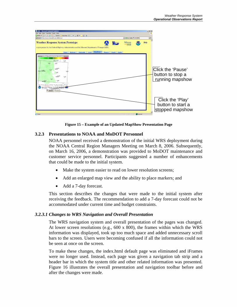
3.2.2.3 Changes made to the MapShow Module Based on recommendations, additional features were provided to the MapShow module. Cookies were used to keep track of user settings for a period of up to seven days. A “Clear Values” button was also added to the MapShow settings page that allows users to reset all data with the click of one button. Figure 14 shows the new “Clear Values” button.
Figure 14 – “Clear Values” Button in MapShow
“Pause” and “Play” buttons were added below each map on the MapShow presentation page. This provides users the ability to stop and start the slideshow as needed. Also, a title was added to each map that states the type of weather condition that is being displayed at that point in time. Figure 15 shows the updated MapShow presentation page.
Weather Response System Operational Observations Report
Figure 15 – Example of an Updated MapShow Presentation Page
3.2.3 Presentations to NOAA and MoDOT Personnel NOAA personnel received a demonstration of the initial WRS deployment during the NOAA Central Region Managers Meeting on March 8, 2006. Subsequently, on March 16, 2006, a demonstration was provided to MoDOT maintenance and customer service personnel. Participants suggested a number of enhancements that could be made to the initial system.
• Make the system easier to read on lower resolution screens;
• Add an enlarged map view and the ability to place markers; and
• Add a 7-day forecast.
This section describes the changes that were made to the initial system after receiving the feedback. The recommendation to add a 7-day forecast could not be accommodated under current time and budget constraints.
3.2.3.1 Changes to WRS Navigation and Overall Presentation
The WRS navigation system and overall presentation of the pages was changed. At lower screen resolutions (e.g., 600 x 800), the frames within which the WRS information was displayed, took up too much space and added unnecessary scroll bars to the screen. Users were becoming confused if all the information could not be seen at once on the screen.
To make these changes, the index.html default page was eliminated and iFrames were no longer used. Instead, each page was given a navigation tab strip and a header bar in which the system title and other related information was presented. Figure 16 illustrates the overall presentation and navigation toolbar before and after the changes were made.
Click the ‘Pause’ button to stop a running mapshow
Click the ‘Play’ button to start a
stopped mapshow

Weather Response System Operational Observations Report
Figure 16 – WRS Presentation and Navigation
Figure 17 provides a before and after picture of the overall WRS presentation and navigation toolbar when used with a 600 x 800 screen resolution. This change eliminated unnecessary scroll bars.
Figure 17 – WRS 600 x 800 Screen Views
3.2.3.2 Add a Larger Map View to the Planner Module Within the Planner module, a “View Large Map” button was added below the existing map. Clicking this button opens a larger map in a pop-up window. The new map is centered on the same location and is shown at the same scale and zoom level as the existing map in the Planner window, but covers a larger area. The map in the pop-up window is a printer-friendly version. The enlarged map in the pop-up window does not affect any functionality of the Planner module.
Figure 18 illustrates the new “View Large Map” button and the pop-up map.

Weather Response System Operational Observations Report
Figure 18 – “View Large Map” Button and Pop-Up Map

Weather Response System Operational Observations Report
4 EVALUATION AND RECOMMENDATIONS
4.1 Introduction The operational evaluation of the prototype WRS was intended to observe various MoDOT users interacting with the system during specific weather events in the Kansas City region. Unfortunately, a very mild winter covering the assessment period meant there were very few events of the types desired.
Instead, toward the end of the evaluation period, the various MoDOT personnel participated in an assessment exercise. Scenarios representing various types of weather event were presented to the users, and their anticipated responses were discussed. In turn, these were used to identify additional features of the WRS that could support or assist in their operational response to the weather event. The recommended additional WRS features are discussed in the following section.
The weather scenarios used in this exercise were based on information prepared for the National Highway Institute (NHI) course number 137030, “Principles and Tools for Road Weather Management,” and the contribution of this material to the WRS project is hereby acknowledged. The assessment exercise focused on the following weather events:
• Snow (a significant snow storm that occurred during December 2005 in the Kansas City region was used as a real-world example for this scenario);
• Black ice (black ice is a major concern in Missouri as temperatures change dramatically upon nightfall when precipitation has occurred during the day);
• Freezing rain (when freezing rain occurs in the Kansas City area, it can accumulate to greater than an inch ice on the roadways);
• Sleet (sleet occurs infrequently in the Kansas City area and usually does not result in major problems);
• Frost (frost occurs frequently in the Kansas City area and is a major concern on the many bridges in the area);
• Thunderstorms (in the Kansas City area and across Missouri, thunderstorms tend to be major events with damaging winds, large hail, torrential rain, numerous lightning strikes, and multiple tornados);
• Rain (in the Kansas City area, rain comes in all forms including light showers, regular rain, heavy downpours, and torrential rains. The rains tend to cause flooding, hydroplaning events on roadways, and drainage blockage.);
• Tornados (tornados typically occur during the spring and fall in the Kansas City area accompanying thunderstorms causing heavy damage to infrastructure); and
• High winds (high winds are normal in the Kansas City area with gusts up to 60 mph, generally affecting operations in the spring and fall).
The MoDOT participants in the assessment exercise represented the following organizational areas of responsibility:

Weather Response System Operational Observations Report
• Transportation Management Centers; • Traffic operations; • Maintenance operations; • Construction operations; and • Customer service.
Their recommendations for changes and enhancements to the prototype WRS are described in section 4.3.
4.2 Available Tools in WRS by Organizational Areas of Responsibility
4.2.1 Transportation Management Centers TMC personnel tend to look at weather from a broad viewpoint. They need to know that weather events might occur for staffing purposes (winter weather) and to help predict its impact on vehicles (speed, volume, occupancy, incidents). The TMC’s primary weather consideration is precipitation in its varying forms.
The tools available in WRS that best meet the needs of the TMC include the following:
• national forecasts to determine if precipitation is predicted for the surrounding area;
• state forecasts to isolate the area of the precipitation;
• local forecasts to specifically watch for precipitation in the Kansas City area;
• the mapshow to run the maps of interest on their computer to keep track of the weather event as it moves and changes;
• the planner as a means to predict inclement weather and staff appropriately; and
• radar to keep track of the weather event as it moves and changes, especially helpful during fast moving thunderstorms.
4.2.2 Traffic Operations Traffic Operations include signals, signage, striping, and lighting. Weather, especially precipitation and wind, is of particular interest to this group since it affects the hazards of dealing with electricity, large materials and equipment, and drying time of paints and adhesives.
The sign department was a strong proponent of using the WRS to determine the wind speed and direction for installing signs. The sign department used the Google map provided in the planner to specify the location for the sign and to provide the information to the installer. Based on the sign department’s recommendation, a larger Google map was provided with the ability to place a marker on the map to show the location of the sign. Also based on their recommendation, WRS interfaces were modified to support a low resolution

Weather Response System Operational Observations Report
monitor. The enhancements made based on the sign department’s recommendations will be used by other departments.
The tools available in WRS that best meet the needs of traffic operations include the following:
• national forecasts to determine if weather events are scheduled in the surrounding areas particularly precipitation and wind speeds;
• state forecasts to isolate the areas that weather events are forecast particularly precipitation and wind speeds;
• local forecasts to watch for weather events in the regional area of Kansas City particularly precipitation and wind speeds;
• the mapshow to set the specific maps to watch for weather events based on location and type of event preferred;
• the planner to specify weather parameters that are needed to perform activities, the enlarged map to pinpoint the location of the activity, and the graphs to determine the appropriate times of performance; and
• radar to watch weather events and their location in relation to performance of work.
4.2.3 Maintenance Operations Weather hampers the ability of maintenance operations during rain, thunderstorms, tornadoes, and high winds and creates substantial work during winter weather events such as snow, freezing rain, sleet, black ice, and frost.
The tools available in WRS that best meet the needs of maintenance operations include the following:
• national forecasts to determine if weather events are expected in the surrounding areas particularly thunderstorms in the spring and fall and winter weather events during the winter months;
• state forecasts to isolate the areas that weather events are forecast particularly thunderstorms in the spring and fall and winter weather events during the winter months;
• local forecasts to watch for weather events in the regional area of Kansas City particularly thunderstorms in the spring and fall and winter weather events during the winter months;
• the mapshow to set the specific maps to watch for weather events based on location and type of event preferred;
• the planner to specify specific weather parameters that are needed to perform activities, the enlarged map to pinpoint the location of the activity, and the graphs to determine the appropriate times of performance; and

Weather Response System Operational Observations Report
• radar to watch weather events and their location in relation to performance of work.
4.2.4 Construction Operations Most of the construction in the state of Missouri is handled by contractors. The contractors are responsible for determining if the weather is appropriate using their own resources for the planned activities. MoDOT’s inspectors use weather information to verify that the activities being performed by the contractors are in accordance with the policies and procedures specified for each construction activity.
The tools available in WRS that best meet the needs of construction operations include the following:
• national forecasts to determine if weather events are scheduled in the surrounding areas of designated construction activities;
• state forecasts to isolate the areas that weather events are forecast in relation to construction activities;
• local forecasts to watch for weather events in the regional area of Kansas City to determine if construction activities should be performed;
• the mapshow to set the specific maps to watch for weather events based on location and type of event preferred;
• the planner to specify specific weather parameters that are needed to perform activities, the enlarged map to pinpoint the location of the activity, and the graphs to determine the appropriate times of performance; and
• radar to watch weather events and their location in relation to performance of work.
4.2.5 Customer Service Customer service receives calls from travelers requesting information on the infrastructure and operations of MoDOT that may be affected by weather and road conditions. In addition, customer service relays weather information to the maintenance, traffic, and construction field personnel.
The tools available in WRS that best meet the needs of customer service include the following:
• national forecasts to determine if weather events are scheduled in the surrounding areas that may impact travelers and field personnel;
• state forecasts to isolate the areas that weather events are forecast that may impact travelers and field personnel;
• local forecasts to watch for weather events in the regional area of Kansas City that may impact travelers and to notify field personnel of approaching adverse weather;

Weather Response System Operational Observations Report
• the mapshow to set the specific maps to watch for weather events based on location and type of event preferred;
• the planner to specify specific weather parameters that are needed to assist travelers with weather information and notify field personnel of inclement weather; and
• radar to watch weather events and their location in relation to respond to users and relay weather information to field personnel.
4.3 Recommended Enhancements to the Prototype WRS
4.3.1 Use of Markers on Expanded Google Maps Clicking on the “View Large Map” in the Planner module opens an expanded Google map in a separate window. In common with all Google map applications, the user can click on a specific location on the map and add a marker. It was recommended that this application be extended within an enhanced WRS to associate additional information with the marker. This information could include additional details of the location in an address-type format. For example, once a location has been selected for placing a sign and the weather conditions are appropriate for installing the sign according to the Planner (e.g., wind speeds are acceptable), the detailed information in the marker on the Google map would help the installation crew find the precise location for placement and installation of the sign.
4.3.2 Maintain the Selected Map View in the Planner The Planner module allows the user to manipulate the small map on the page to select a specific geographic view and zoom level. However, if the user exits the planner to access another module of the WRS and then returns to the Planner, the map view has changed back to the default view. Users recommended that a tool be provided in the Planner module that allowed a selected map view to be maintained at the user’s selection.
4.3.3 Provide a Regional Kansas City Map View Users can currently select views of individual states (e.g., Missouri or Kansas) or views of smaller geographic areas (e.g., Kansas City). Selecting the Kansas City map, however, provides a Missouri-centric view of the region (i.e., it covers the whole of Kansas City but with the metropolitan area to the left (west) side of the display and therefore showing a greater portion of Missouri). Users suggested an alternative display that still emphasized the Kansas City region but allowed a greater portion of Kansas to be viewed. This was considered important since the prevailing weather conditions typically move west to east. Therefore, seeing more of Kansas provides additional notice of approaching weather events. This feature could be accomplished in an enhanced WRS through some additional development. However, using the MapShow module in the prototype WRS allows users to select two maps (primary and secondary locations) for display, and could serve as an interim solution to this need.

Weather Response System Operational Observations Report
4.3.4 Display Default Maps for Each Tab The prototype WRS allows users to select National, State, or Local views of weather maps via tabs. Once the user clicks on a tab, a new page opens from which the user can selected a type of weather map and a location. The new page opens without any map being displayed until the user makes a selection. Users recommended that a default weather map and location should be presented on the page when the user clicks the tab, and from there the user could select an alternative weather map and location using the tools. The purpose of this recommended change was to immediately present a graphic to the user which would draw them in and encourage them to make further selections.
4.3.5 Provide Forecast Pop-Ups Users recommended that instead of using static graphic images for the State and Local views, users should be able to cursor over the maps and click at specific locations to obtain a pop-up box containing the forecast for that location. Currently, selected NWS products provide this capability for general forecast information. This capability could be integrated with WRS in the future.
4.3.6 Provide Ability to Email or Page a Forecast Users recommended developing an application that would allow forecasts of selected weather events for specific locations or regions to be emailed or sent by pager from one MoDOT user to another. Receiving users might be either field personnel, or in another office such as the TMC. MoDOT currently has the ability to send emails of weather forecasts using a service provided by their existing commercial weather information provider. It was felt that incorporating this functionality within WRS could lead to cost savings for MoDOT.
4.3.7 Provide Email and Pager Alerts This is similar to the previous recommendation. However, in this case it was suggested that the WRS should automatically send alerts to MoDOT users in emails or by pager when certain weather parameter thresholds are met or exceeded for selected types of weather events and locations. The types of events, locations, and thresholds should be user-selectable.
4.3.8 Provide long-range general forecasts The current version of the WRS provides a variety of weather maps with different forecast periods. In the National Weather Maps module these range from current conditions to three-day forecasts; in the State Weather Maps module they range from current conditions to 24-hour forecasts; and in the Local Weather Maps module they range from current conditions to 12-hour forecasts. Users recommended that additional longer-range general forecasts be provided through WRS. It was recommended that these cover a period of 7 to 10 days. This was seen as particularly valuable for planning and scheduling maintenance activities and resources, as well as preparing for major weather events in all MoDOT organizational areas. There are a variety of existing NWS text and graphical

Weather Response System Operational Observations Report
products that provide long-range general forecasts. These include products that allow users to search by city, state, or zip code and display current conditions and 7-day forecasts, or to make location selections from clickable maps and display 7-day forecasts for a variety of weather types. These products could be integrated into WRS in the future.
4.3.9 Provide longer forecast periods in MapShow This is similar to the issue described above. The MapShow module uses the same weather maps as the National, State, and Local Weather Map modules these range from current events to 24-hour forecasts, but with most weather maps providing 4 to 6 hour forecasts. The users recommended providing 24- to 48-hour forecasts for most types of weather map.
4.3.10 Provide storm tracking capability Users recommended that a storm tracking capability be added to the WRS. This would cover various types of storm events, including snowstorms, ice storms, significant rain storms, and thunderstorms. It was suggested that the storm tracking capability should graphically display the forecast progress of the storm, and should provide the ability to determine an estimated time of arrival at user-specified locations. The users felt that this capability would have multiple applications within MoDOT. For example, it would provide benefits in preparing for impending winter storms by allowing maintenance operations to know which roadways would be affected earliest, and to dispatch crews to those locations to apply pre-treatments. The storm tracking capability could also be used for managing field maintenance operations year-round. Crews could be notified of approaching thunderstorms, and with the arrival-time estimates could be advised when to terminate their activities in the field.
4.3.11 Provide information on type of precipitation The prototype WRS includes a number of weather maps that provide probability of precipitation and precipitation amount in each of the National, State, and Local Weather Maps modules. Users recommended that additional information about the type of precipitation (e.g., rain, freezing rain, sleet, snow) should be provided in both the weather maps and the planner. Users also recommended that the time at which the precipitation is forecast to reach a user-selected location should be added to the weather maps.
4.3.12 Provide information on precipitation rates The prototype WRS includes weather maps that provide forecast precipitation amounts in the National, State, and Local Weather Maps modules. Users recommended that additional information on precipitation rate should be added. This can be valuable information to maintenance operations personnel. For example, if three inches of rain were forecast to fall in one hour, maintenance personnel would be dispatched to induce drainage along known ponding segments of roadway.

Weather Response System Operational Observations Report
4.3.13 Provide probability of hail Users recommended adding weather maps that would provide the probability of hail in the region. The NWS Storm Prediction Center provides data on the probability of hail, so potentially weather maps with this information could be added to an enhanced WRS.
4.3.14 Provide lightning information Users recommended adding lightning information to the weather maps in the State and Local Weather Maps modules, and to the planner. The objective was to see forecasts of probable lightning strike locations and the estimated times at which lightning would reach user-specified locations. This information could be used in maintenance and construction planning prior to dispatching field crews. Information of this type is available through the U.S. National Lightning Detection Network, a commercial lightning detection network operated by the Vaisala Group. There is, therefore, potential to explore the value of this service to MoDOT personnel and integrate it within an enhanced WRS. However, there would then be an associated fee-for-service.
4.3.15 Provide additional dew-point and humidity information The prototype WRS includes a 3-hour dewpoint temperature map in the State Weather Maps module and a 1-hour dewpoint temperature map in the Local Weather Maps module. Users recommended additional dewpoint and humidity information be added to the enhanced WRS. For example, longer-range dewpoint temperature forecasts and data for user-selectable locations would be valuable. It was also requested that dewpoint temperature be added to the Planner module. MoDOT personnel indicated that this data is important for decisions about bridge painting, for example. Currently, a field representative is sent to the bridge location to take a humidity reading before a final decision is made to start painting on a particular day.
4.3.16 Provide frost information MoDOT maintenance personnel indicated the importance of accurate information about the location and probability of frost, especially on bridges. Even if current forecast information shows a low probability of frost, MoDOT dispatches maintenance personnel to assess the actual field condition, particularly on bridges that are know to be especially susceptible. More detailed information of this type will likely require data from ESS devices to achieve the accuracy and resolution required by MoDOT, rather than relying on forecast products from the NWS. This option could be explored in the development of an enhanced WRS.
4.3.17 Provide pavement temperatures Many winter weather treatment strategies used by MoDOT maintenance personnel would benefit from the availability of specific pavement temperature data, either for specific user-selectable locations or for specific roadway segments. More detailed information of this type will likely require data from

Weather Response System Operational Observations Report
ESS devices to achieve the accuracy and resolution required by MoDOT, rather than relying on forecast products from the NWS. This option could be explored in the development of an enhanced WRS.
4.3.18 Provide river cresting information MoDOT maintenance personnel would like information on river cresting and the probability of flooding. However, this information would need to relate to specific highway locations, particularly those susceptible to flooding, standing water, or drainage problems. The NWS currently provides a variety of hydrographic information using data from sensors operated by other agencies, including the U.S. Geological Survey and the U.S. Army Corps of Engineers. This information includes both text and graphical products that describe current river levels and associated flood levels. In some instances, forecast probability of flooding is also provided. However, this data relates to specific river locations and is not associated with roadway locations. The use of additional sensors or the extrapolation of the existing sensor data to roadway locations could be explored in the development of an enhanced WRS.
4.3.19 Provide ozone information The Mid-America Regional Council (MARC) currently provides an ozone alert system for the Kansas City region. MARC provides daily updates, and KC Scout uses notifications of “orange” and “red” days to provide information to drivers via dynamic message signs on the freeways. Maintenance operations personnel indicated the value of this information in their planning and scheduling activities, and the benefit of integrating this information with weather information, especially in the Planner module. For example, this information could be used to defer maintenance activities that would contribute to poor air quality, or to avoid dispatching field crews if air quality is unhealthy.
4.3.20 Provide customizable displays Users requested that an enhanced WRS contain additional customization features. In particular, it was suggested that each user should be able to create customized views from multiple individual modules (e.g., select a specific location for the Regional Weather Maps, and include specific parameters in the Planner/Graph modules), and relate these to a specific long-term project activity (e.g., “I-35 Overlay” or “Paseo Bridge”). The WRS home page would then include a drop-down menu that would list all of the specific user’s projects. Selecting any particular project from the list would allow each WRS module to open with the user’s customized view for the specific project.
4.4 Conclusions The MoDOT users who participated in the operational assessment exercise identified multiple enhancements that could be made to the WRS. It appears that the users believe that these enhancements would provide value in their respective day-to-day activities in traffic operations, maintenance operations, construction operations, or customer service.

Weather Response System Operational Observations Report
An initial review of the recommendations indicates that many of the suggestions are feasible additions to WRS. It is strongly believed that these could be successfully developed and implemented in a subsequent phase of the WRS project.
4.5 Contractor Recommendations The FHWA Road Weather Management program has raised the awareness of the needs of the surface transportation community for better, more tailored weather and road condition information. In the past, the primary focus has been on the needs of winter weather response, such as through the MDSS. A newer program, the Clarus National Surface Transportation Weather Observations System, has been developed to collect, quality check, and disseminate environmental and hydrological observations from departments of transportation across North America. Clarus will allow departments of transportation to evaluate changing surface weather conditions from adjacent states to determine its impact on the traveling public, infrastructure, and planned activities.
This project has documented the user needs and has deployed a prototype WRS. It established a foundational understanding of the need for year-round weather information to support DOT operations. A prime example of the need for WRS has been provided by the MoDOT District 4 sign department. Wind is of particular concern when installing signs adjacent to or over roads. The criteria established for sign installation is that wind speeds should be less than five miles per hour. The sign department used the prototype WRS to determine the speed and direction of the wind, and, in turn, was able to determine where signs could be installed safely under current and forecast conditions. The system also allowed them to place larger signs when the wind was slightly greater than five miles per hour but the wind direction would help hold the sign against the support structure during installation. Without the prototype WRS, the sign department would have used generalized weather information to make the decision or they would physically evaluate the wind speed and direction at the installation site, incurring wasted resources when installation was deemed unsafe.
As described in section 4.2, the recommendations submitted by MoDOT for future enhancements of the WRS are all reasonable and feasible. The majority of the weather information and forecasts suggested for inclusion by MoDOT are readily available, although it is likely that some information accessible through the NWS would need to be customized to meet MoDOT’s specific requirements, and some data (such as lightning predictions) would need to be purchased for use in an enhanced WRS. As the WRS development contractor, Mixon/Hill recommends that the MoDOT-proposed enhancements be implemented in a future version of the WRS.
Further, Mixon/Hill recommends that an enhanced version of the WRS should be considered with the following additional characteristics:
• Develop specific decision support tools for MoDOT users. These will include those that can be used for maintenance needs (for example, sign

Weather Response System Operational Observations Report
installation: wind speed – less than five miles per hour), plus detailed additional exploration of the decision support needs in traffic operations;
• The integration of an MDSS component for winter maintenance decision support into WRS that allow agencies with interests in a broad range of year-round surface transportation weather conditions to deploy a single system;
• Inclusion of Clarus observations from MoDOT and surrounding states to be graphically displayed, and potentially to be integrated into the decision support tools as appropriate;
• A logging and archiving capability for predicted/forecast and measured weather parameter data to be recorded and analyzed on an historical basis;
• A weather information processing module for calculating derived weather parameters; and
• Enhanced graphical displays of real-time and forecasted weather maps.
Departments of transportation face major challenges during the scheduling and execution of activities that are affected by surface weather. Without the proper real-time and forecast weather information and the tools to manipulate that data, the traveling public and DOT personnel are put at risk; material, labor, time, and monetary resources are wasted; public notification of weather and road conditions is delayed; and the information available regarding current field construction and maintenance activities may be inaccurate or out-of-date. An enhanced WRS incorporating the various recommended enhancements will go a long way to addressing these challenges.

Weather Response System Operational Observations Report
APPENDIX A - DEFINITIONS, ACRONYMS, AND ABBREVIATIONS The following table provides the definitions of all terms, acronyms, and abbreviations used in this document.
Term Definition AMS American Meteorological Society
CCTV Closed Circuit Television
ConOps Concept of Operations
DMS Dynamic Message Sign
DOT Department of Transportation
DTN Data Transmission Network
ESS Environmental Sensor Station
FHWA Federal Highway Administration
HAZMAT Hazardous Materials
MARC Mid-America Regional Council
MDSS Maintenance Decision Support System
MoDOT Missouri Department of Transportation
NHI National Highway Institute
NDFD National Digital Forecast Database
NHI National Highway Institute
NOAA National Oceanic and Atmospheric Administration
NWS National Weather Service
RWIS Road Weather Information System
SRS System Requirements Specification
SysAD System Architectural Description
TIC Transportation Information Center
TMC Transportation Management Center
TOC Transportation Operations Center
U.S. DOT United States Department of Transportation
WRS Weather Response System

Weather Response System Operational Observations Report
ROEMER ALFELOR
Publication Number: FHWA-HOP-07-067
EDL Number: 14338
Department of Transportation
Office of Operations Room 3408
400 Seventh St SW
Washington, DC 20950