Operation of storm surge monitoring system of NORI … of storm surge monitoring system of NORI for...
29
Operation of storm surge monitoring system of NORI for coastal disaster prevention Operation of storm surge monitoring system of NORI for coastal disaster prevention National Oceanographic Research Institute Ministry of Maritime Affairs and Fisheries National Oceanographic Research Institute Ministry of Maritime Affairs and Fisheries
Transcript of Operation of storm surge monitoring system of NORI … of storm surge monitoring system of NORI for...
Operation of storm surge monitoring system
of NORI for coastal disaster prevention
Operation of storm surge monitoring system
of NORI for coastal disaster prevention
National Oceanographic Research Institute
Ministry of Maritime Affairs and Fisheries
National Oceanographic Research Institute
Ministry of Maritime Affairs and Fisheries
I. STATUS OF OCEAN OBSERVATIONI. STATUS OF OCEAN OBSERVATION
II. Ocean Monitoring BuoyII. Ocean Monitoring Buoy
III. ARGOS BuoyIII. ARGOS Buoy
IV. Problem and improvementIV. Problem and improvement
ContentsContents

I.I. STATUS OF OCEAN OBSERVATION
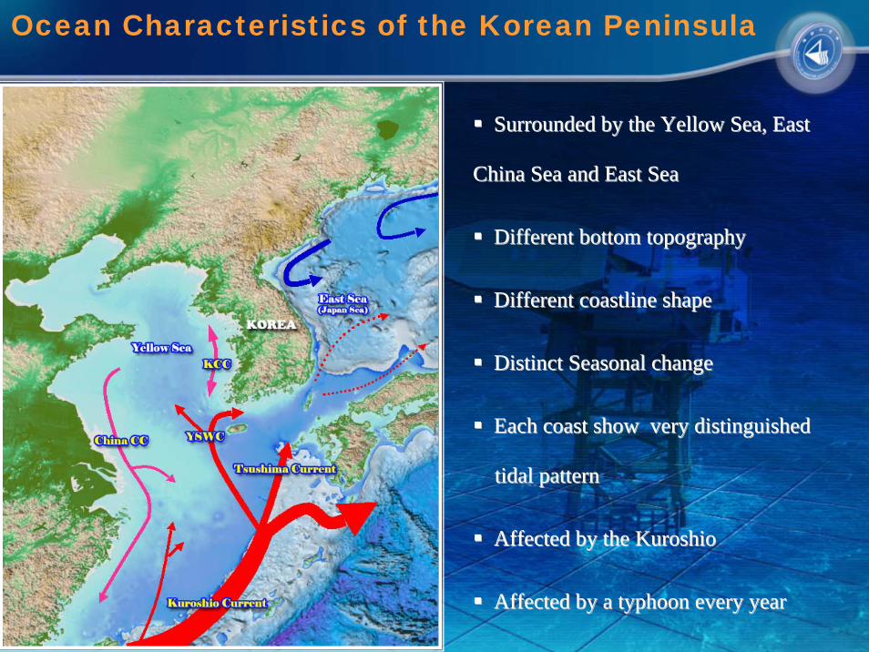
Ocean Characteristics of the Korean Peninsula
Surrounded by the Yellow Sea, East Surrounded by the Yellow Sea, East
China Sea and East SeaChina Sea and East Sea
Different bottom topographyDifferent bottom topography
Different coastline shapeDifferent coastline shape
Distinct Seasonal changeDistinct Seasonal change
Each coast show very distinguished Each coast show very distinguished
tidal patterntidal pattern
Affected by the Affected by the KuroshioKuroshio
Affected by a typhoon every yearAffected by a typhoon every year

July 2001 : A Basic Plan for the establishment of the National Ocean
Observation Network was set up.
July 2002 : A Long-term Plan for the operation of Ieodo Ocean Station was
decided
June 2003 : Construction of Ieodo Ocean Station
Feb. 2006 : Internal Plan of the transfer of all ocean observation stations to
NORI was fixed.
2007 now : NORI operate all ocean observation stations including Ieodo
Ocean Station.
National Real-Time Ocean Observation Network

○ 91 observing stations will be established
by 2010 (59 stations , 2006)
- Ocean observation base : 5
- Lighthouse observatory : 20
- Dolphin observatory : 20
- Ocean buoy : 8
- Tidal station : 38
○ Ocean phenomenon such as tide,
wave, water temperature, current and
weather, etc.systematically is observed
and provided in real-time
National Real-Time Ocean Observation Network
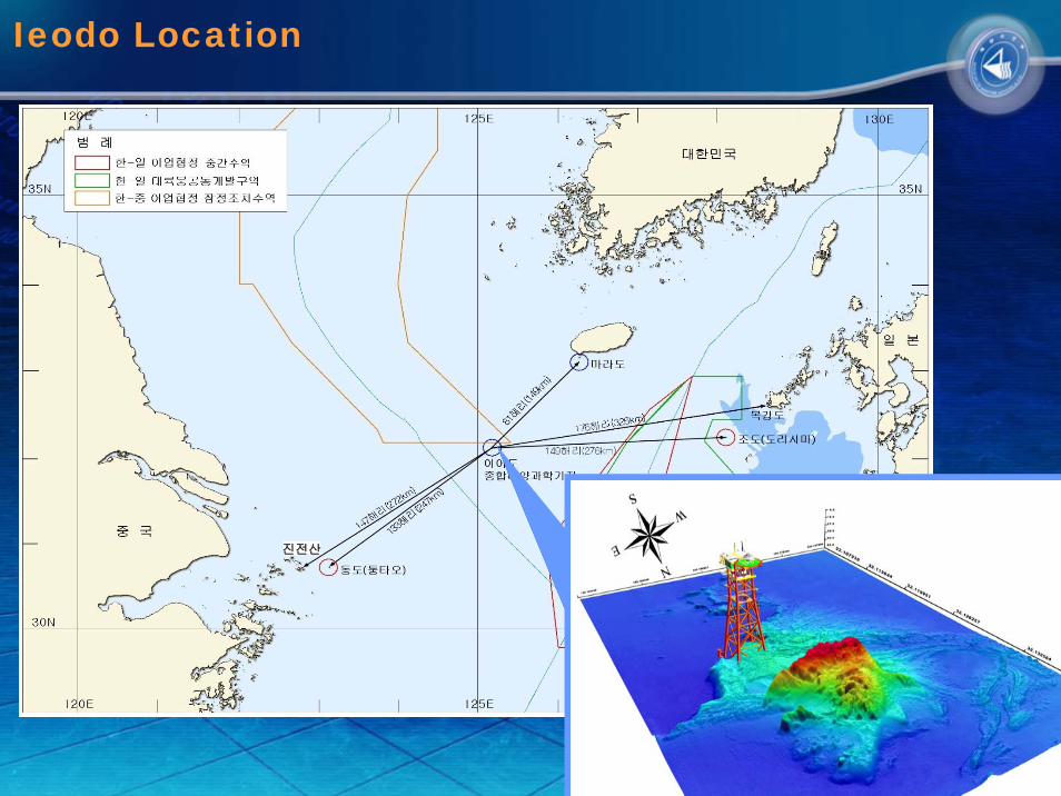
진전산
Ieodo Location

wave radar ADCP
weather sensor CTD
-- Total Height: 77m (underwater : 40m) Total Height: 77m (underwater : 40m)
-- Total weight: 3,400t Total weight: 3,400t
-- Main Deck: lab, seminar room, bed, etc Main Deck: lab, seminar room, bed, etc
-- Cellar Deck: generator, battery roomCellar Deck: generator, battery room
-- Equipment: 108 (44 types)Equipment: 108 (44 types)
·· AtmosAtmos. obs. : 41 (14 types) . obs. : 41 (14 types)
·· Ocean obs. : 40 (21 types) Ocean obs. : 40 (21 types)
·· Structure safety obs. : 19 (4 types) Structure safety obs. : 19 (4 types)
·· Environment obs. : 8 (5 types)Environment obs. : 8 (5 types)
Ieodo Ocean Research Station

Ocean Monitoring BuoyOcean Monitoring BuoyOcean Monitoring Buoy
○ Introduction- Provide boundary conditions for surgeprediction
- Complementary data supply for ocean current observation
- Acquisition of weather data in bad weather, such as typhoon and Produce current data
○ Application plan- Provide calibration and verification data for ship-mounted ADCP
- Calculation of boundary conditions- Long and short-term prediction of tidal and ocean current
Ocean Observation – Ocean Buoy
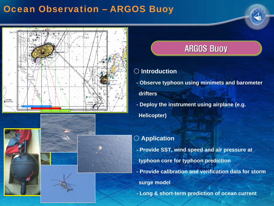
ARGOS BuoyARGOS BuoyARGOS Buoy
○ Introduction
- Observe typhoon using minimets and barometer
drifters
- Deploy the instrument using airplane (e.g.
Helicopter)
○ Application
- Provide SST, wind speed and air pressure at
typhoon core for typhoon prediction
- Provide calibration and verification data for storm
surge model
- Long & short-term prediction of ocean current
Ocean Observation – ARGOS Buoy
II.II. Ocean Monitoring Buoy

Decision of buoy installation position
<Typhoon Track distribution map><Typhoon Track distribution map>
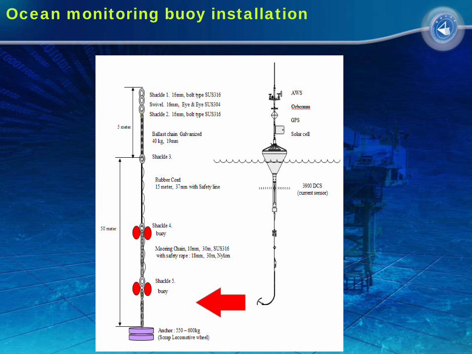
Ocean monitoring buoy installation

Meteorological Sensors Hydrological Sensors
Wind Direction Sensor
Wind Speed Sensor
MIRA Visibility Sensor
Air Pressure Sensor
Air Temperature Sensor
Wave Height Sensor
Buoy Orientation Sensor
C/T Sensor
Doppler Current Sensor

General type of buoy
Counter weight lowering the center of gravity
High Bending Radiuswith stress on cable and Instrumentation
Small Bending radius Giving very littleor no stress on cable and instrumentation
move up and down vertically
Acorn buoy is shaped for sub sea installations and to handle waves and swells


Buoy monitoring Program

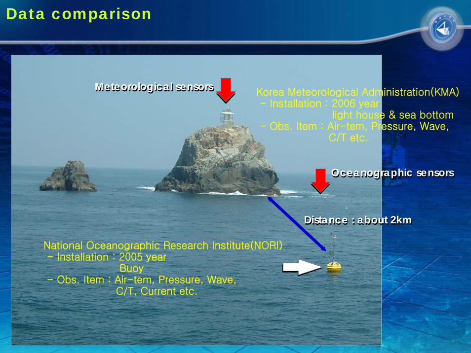
Korea Meteorological Administration(KMA)- Installation : 2006 year
light house & sea bottom- Obs. Item : Air-tem, Pressure, Wave,
C/T etc.
National Oceanographic Research Institute(NORI)- Installation : 2005 year
Buoy- Obs. Item : Air-tem, Pressure, Wave,
C/T, Current etc.
Distance : about 2kmDistance : about 2km
Oceanographic sensorsOceanographic sensors
Meteorological sensorsMeteorological sensors
Data comparison

No. 11 Typhoon “NARI” Track - 2007

Wind Speed (2007. 9. 11 ~ 9.23)
-5
0
5
10
15
20
25
30
35
2007
/09/
11 0
1:00
2007
/09/
11 1
8:00
2007
/09/
12 1
1:00
2007
/09/
13 0
4:00
2007
/09/
13 2
1:00
2007
/09/
14 1
4:00
2007
/09/
15 0
7:00
2007
/09/
16 0
0:00
2007
/09/
16 1
7:00
2007
/09/
17 1
0:00
2007
/09/
18 0
3:00
2007
/09/
18 2
0:00
2007
/09/
19 1
3:00
2007
/09/
20 0
6:00
2007
/09/
20 2
3:00
2007
/09/
21 1
6:00
2007
/09/
22 0
9:00
2007
/09/
23 0
2:00
2007
/09/
23 1
9:00
buoylight house
Air Pressure (2007. 9. 11 ~ 9.23)
980
985
990
995
1000
1005
1010
1015
1020
1025
2007
/09/
11 0
1:00
2007
/09/
11 1
8:00
2007
/09/
12 1
1:00
2007
/09/
13 0
4:00
2007
/09/
13 2
1:00
2007
/09/
14 1
4:00
2007
/09/
15 0
7:00
2007
/09/
16 0
0:00
2007
/09/
16 1
7:00
2007
/09/
17 1
0:00
2007
/09/
18 0
3:00
2007
/09/
18 2
0:00
2007
/09/
19 1
3:00
2007
/09/
20 0
6:00
2007
/09/
20 2
3:00
2007
/09/
21 1
6:00
2007
/09/
22 0
9:00
2007
/09/
23 0
2:00
2007
/09/
23 1
9:00
buoylight house
Water Temperature (2007. 9. 11 ~ 9.23)
2323.5
2424.5
2525.5
2626.5
2727.5
28
2007
/09/
11 0
1:00
2007
/09/
11 1
8:00
2007
/09/
12 1
1:00
2007
/09/
13 0
4:00
2007
/09/
13 2
1:00
2007
/09/
14 1
4:00
2007
/09/
15 0
7:00
2007
/09/
16 0
0:00
2007
/09/
16 1
7:00
2007
/09/
17 1
0:00
2007
/09/
18 0
3:00
2007
/09/
18 2
0:00
2007
/09/
19 1
3:00
2007
/09/
20 0
6:00
2007
/09/
20 2
3:00
2007
/09/
21 1
6:00
2007
/09/
22 0
9:00
2007
/09/
23 0
2:00
2007
/09/
23 1
9:00
buoylight house
Signigicant Wave Height (2007. 9. 11 ~ 9.23)
0
2
4
6
8
10
12
14
2007
/09/
11 0
1:00
2007
/09/
11 1
8:00
2007
/09/
12 1
1:00
2007
/09/
13 0
4:00
2007
/09/
13 2
1:00
2007
/09/
14 1
4:00
2007
/09/
15 0
7:00
2007
/09/
16 0
0:00
2007
/09/
16 1
7:00
2007
/09/
17 1
0:00
2007
/09/
18 0
3:00
2007
/09/
18 2
0:00
2007
/09/
19 1
3:00
2007
/09/
20 0
6:00
2007
/09/
20 2
3:00
2007
/09/
21 1
6:00
2007
/09/
22 0
9:00
2007
/09/
23 0
2:00
2007
/09/
23 1
9:00
buoylight house

III.III. ARGOS Buoy

ARGOS Location
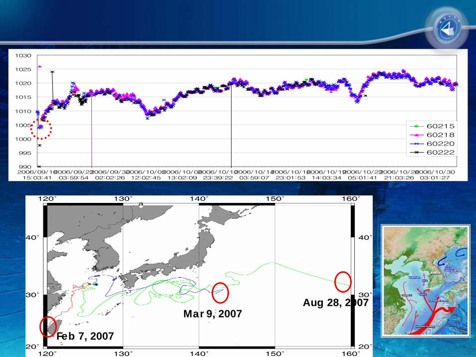
<Dropping position & way of a Drifting Buoy><Dropping position & way of a Drifting Buoy>
○ Dropping line of a buoy with Blue, Red, Green according to a path of a typhoon
○ A buoy keeps 30km interval and drops
○ A dropping of a buoy uses a parachute
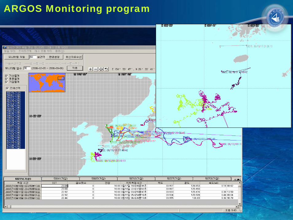
ARGOS Monitoring program

No. 13 Typhoon “SHANSHAN” Track
Dropping line(2006.9.16)
990
995
1000
1005
1010
1015
1020
1025
1030
2006/09/1615:03:41
2006/09/2303:59:54
2006/09/3002:02:26
2006/10/0512:02:45
2006/10/0813:02:09
2006/10/1023:39:22
2006/10/1403:59:07
2006/10/1623:01:53
2006/10/1914:03:34
2006/10/2305:01:41
2006/10/2621:03:26
2006/10/3003:01:27
60215
60218
60220
60222
Feb 7, 2007
Aug 28, 2007Mar 9, 2007
IV.IV. Problem and improvement
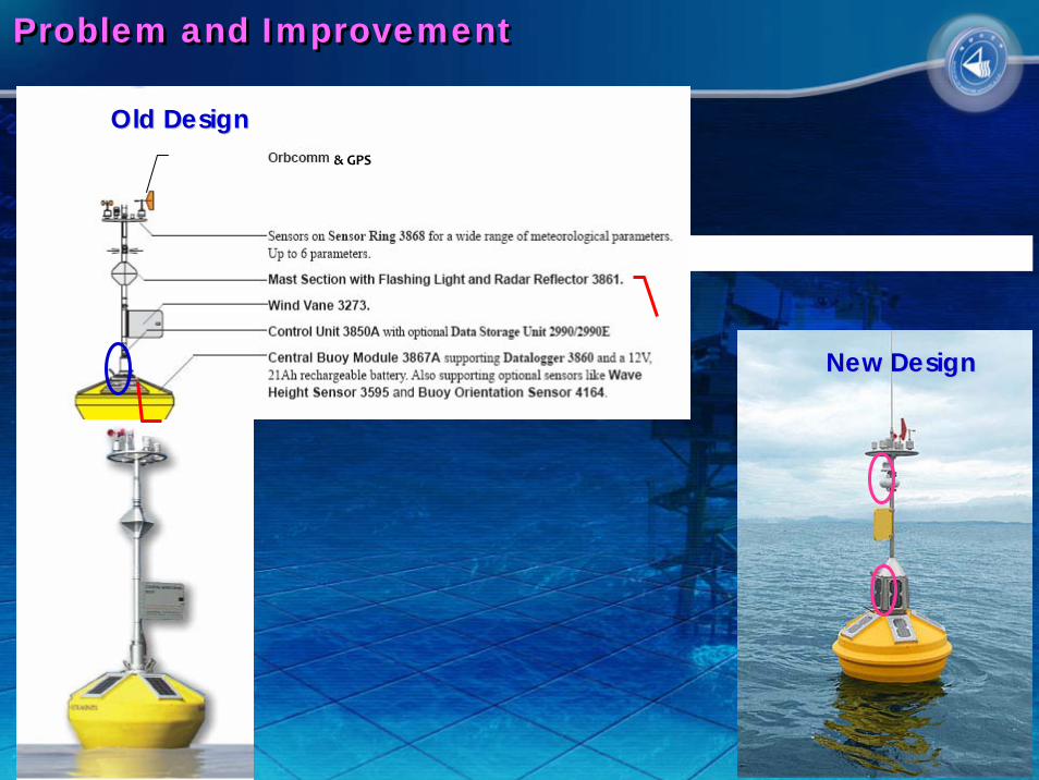
Problem and ImprovementProblem and Improvement
& GPS
Old DesignOld Design
New DesignNew Design

THANK YOUTHANK YOU