Remote Sensing in Support of NACP Jeffrey G. Masek Biospheric Sciences, NASA GSFC January 23, 2007.

1 SLI Architecture Study Interim Status Briefing, April 1, 2014
Suomi NPP VIIRS Visible Composite
SUSTAINABLE LAND IMAGING (SLI) ARCHITECTURE STUDY
Interim Status Briefing
Opening Statements
Stephen Volz Associate Director for Flight Programs
NASA Earth Science Division April 1, 2014

2 SLI Architecture Study Interim Status Briefing, April 1, 2014
Time (EDT) Topic Speaker
8:30-9:00 Check-in
9:00-9:05 Opening Statements Steve Volz Associate Director for Flight Programs NASA Earth Science Division Tim Newman Program Coordinator for Land Remote Sensing U.S. Geological Survey
9:05-9:15 Introduction & Overview Del Jenstrom, Architecture Study Team Manager NASA Goddard Space Flight Center
9:15-9:20 Science Introduction Jeff Masek NASA Goddard Space Flight Center
9:20-9:35 USGS User Needs Assessment Jim Nelson USGS Earth Resources Observation & Science Center
9:35-9:55
Imaging Performance Characteristics
Jeff Masek NASA Goddard Space Flight Center
9:55-10:10 Representative Instrument Concepts
Phil Dabney NASA Goddard Space Flight Center
10:10-10:25 Architecture Assessment Process
Tony Freeman NASA Jet Propulsion Laboratory
10:25-10:50 Summary of Initial Findings Evan Webb NASA Goddard Space Flight Center
10:50-11:00 Remaining Study Plans Del Jenstrom, Architecture Study Team Manager NASA Goddard Space Flight Center
11:00-12:00 Q&A All
Agenda

3 SLI Architecture Study Interim Status Briefing, April 1, 2014
§ This study direction was affirmed in the January 2014 appropriations, with some comments from the Congress
§ Beginning with $30 million in FY14 for NASA to study options for a future sustained land imaging system, in collaboration with USGS.
§ The study shall define a system for sustained global land-imaging multispectral and thermal infrared information for an approximately 20-year period starting in 2018.
§ The study should provide options which consider various weightings of near-term capability, continuity/gap risk mitigation, and technology infusion over the system's lifetime.
SLI Study Direction to NASA
In FY14 NASA will initiate the definition of a sustained, space-based, global land imaging capability for the nation, ensuring continuity following LDCM. Near-term activities led by NASA, in cooperation with USGS, will focus on studies to define the scope, measurement approaches, cost, and risk of a viable long-term land imaging system that will achieve national objectives. Evaluations and design activities will include consideration of stand-alone new instruments and satellites, as well as potential international partnerships. It is expected that NASA will support the overall system design, flight system implementation, and launch of future missions, while USGS will continue to fund ground system development, post-launch operations, and data processing, archiving, and distribution.
- President’s FY2014 Budget release for NASA
Administration Direction
Delivery Date Aug 15, 2014

4 SLI Architecture Study Interim Status Briefing, April 1, 2014
Three Basic Tenets for the SLI Program ª Sustainability
❑ The SLI program should provide the data products for the long haul, without extraordinary infusions of funds, within the budget guidance provided.
❑ It should also ensure the technology required for the program is available and appropriate for the long haul
ª Continuity ❑ The SLI program should continue the long term Landsat data record. This does
not necessarily mean the imagery per se, but the usable products that define the utility of the data record.
❑ Understanding how the data are used is essential when considering potential architectures.
ª Reliability ❑ The SLI program should exhibit a form of functional redundancy. The data sets
should be able to draw on equivalent or near equivalent deliverables from different sources to provide the data for the highest priority land imaging data products.
❑ With these “near equivalent” data sources identified in advance, the loss of a single satellite or instrument on orbit should not cripple the program or significantly impact users, and the program will exhibit graceful degradation.

5 SLI Architecture Study Interim Status Briefing, April 1, 2014
DOI$USGS( NASA$ESD(
ESM(PO(Sustainable(Land(Imaging(Architecture(
Study(Team(
Data(U@liza@on(
Space(Segment(
Cost(&(Risk(Modeling(
Ground(Segment(
Management(&(Business(Models(
NUSLISSC(
NASA RFI Responses
Sustainable Land Imaging Study Execution
Landsat Science Team
Data providers & product developers
Landsat User Community
Space Industrial Community International participants
Direction Coordination
ª NASA leads the study, closely coordinated with USGS
ª Multi-disciplinary Architecture Study Team (AST) executes the study for NASA
ª AST is essentially governmental, including NASA, USGS, Aerospace, FFRDC
ª We actively seek input from multiple sources and have taken multiple opportunities for community engagement
ª The AST reports to the NASA ESD and NASA reports to the OSTP in August 2014

6 SLI Architecture Study Interim Status Briefing, April 1, 2014
Established a Study Schedule in September FY13 Accomplishments ª Kick-off briefing to Administration Aug 6, 2013 ª Establish Architecture Study Team (AST) Sept 2013 ª Industry & Partner Day, RFI Release Sept 18, 2013
ª Landsat User’s Forum Dec 4, 2013 FY14 Activities & Plans ª 1st Quarterly briefing to Stakeholders Nov 21, 2013 ª 2nd Quarterly briefing to Stakeholders Jan 27, 2014 ª AST Design Cycle 2 Jan 27-Mar 15, 2014 ª 3rd Quarterly briefing to Stakeholders Mar 18, 2014 ª SLI Community/Industry Forum Apr 1, 2014 ª NASA ESD SLI interim report to Congress May 18, 2014 ª AST completion of full SLI program options May 15-Jul 15, 2014 ª Completion of SLI study report Jul 2014 ª NASA/USGS SLI report to Administration Aug 15, 2014
SLI Design
Cycle #1
SLI Design
Cycle #2
SLI Design
Cycle #3

7 SLI Architecture Study Interim Status Briefing, April 1, 2014
RBI OMPS-Limb
TSIS-2
JPSS-2 (NOAA)
SLI Satellites to be defined
Formulation in 2015
NASA Earth Science Missions In Operation, Development, and Formulation

8 SLI Architecture Study Interim Status Briefing, April 1, 2014
What are the SLI Study Deliverables? ª We have a 25 year program challenge to address, and we
recognize the likelihood that the solution for the near term may be different, may evolve into a different form for the longer term
ª Near-Term Solution ❑ Will be defined at the outcome of this study activity in August 2014 ❑ Project and mission implementation activities, including
procurement of mission elements, are expected in CY2014 ª Mid- and Long-Term Solution(s)
❑ We expect to identify possibilities for architecture options, but do not expect to know enough to firmly define them at this time
❑ We need to understand what potential future capabilities and technologies may have, and what we can do now to better understand them
❑ We plan to release study contracts in the coming months to inform these potential options

9 SLI Architecture Study Interim Status Briefing, April 1, 2014
ª Please step up to the microphone, and speak clearly into it with questions
ª Please state your name and affiliation, then your question
ª Questions from those watching online can be submitted to the following e-mail address:
[email protected] ª For questions submitted via e-mail, please include your
name and affiliation
Questions

SLI Architecture Study Interim Status Briefing -‐ Public Release April 1, 2014
Sustained Land Imaging Architecture Study Interim Status Briefing
NASA Headquarters April 1, 2014
1

SLI Architecture Study Interim Status Briefing -‐ Public Release April 1, 2014
Time (EDT) No. Topic Speaker
8:30-9:00 Check-in
9:00-9:05 Opening Statements Steve Volz Associate Director for Flight Programs NASA Earth Science Division
Tim Newman Program Coordinator for Land Remote Sensing U.S. Geological Survey
9:05-9:15 1 Introduction & Overview Del Jenstrom, Architecture Study Team Manager NASA Goddard Space Flight Center
9:15-9:20 2 Science Introduction Jeff Masek NASA Goddard Space Flight Center
9:20-9:35 3 USGS User Needs Assessment Jim Nelson USGS Earth Resources Observation & Science Center
9:35-9:55
4 Imaging Performance Characteristics Jeff Masek NASA Goddard Space Flight Center
9:55-10:10 5 Representative Instrument Concepts Phil Dabney NASA Goddard Space Flight Center
10:10-10:25 6 Architecture Assessment Process Tony Freeman NASA Jet Propulsion Laboratory
10:25-10:50 7 Summary of Initial Findings Evan Webb NASA Goddard Space Flight Center
10:50-11:00 8 Remaining Study Plans Del Jenstrom, Architecture Study Team Manager NASA Goddard Space Flight Center
11:00-12:00 Q&A All
Agenda

SLI Architecture Study Interim Status Briefing -‐ Public Release April 1, 2014
1. INTRODUCTION AND OVERVIEW Del Jenstrom – AST Manager
3

SLI Architecture Study Interim Status Briefing -‐ Public Release April 1, 2014
Land Imaging AST Charge, Process, & Membership
4
Land Imaging AST Charge (September 2013) • Define a Sustainable Land Imaging (SLI) system delivering global land-‐imaging
mulOspectral and thermal infrared informaOon for a 20-‐year period starOng in 2018 • Provide opOons which consider various weighOngs of near-‐term capability, conOnuity/
gap risk miOgaOon, technology infusion over the system's lifeOme, and cost • Consider refined capabiliOes requested by the user communiOes • Include consideraOon of new measurement approaches, as well as potenOal
internaOonal and private sector partnerships
AST Study Process • Establish study trade space via expert knowledge, intensive AST discussions, and RFI
responses • Trade space is explored via several design cycles, and adjusted through each • Appealing architectures that are likely to saOsfy budget constraints are further refined
and assessed
AST Membership • RepresentaOves from NASA/GSFC, NASA/LaRC, NASA/ARC, JPL, USGS, JHU/APL,
Aerospace, and MIT/LL
SLI Architecture Study Interim Status Briefing -‐ Public Release April 1, 2014
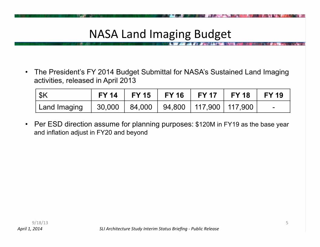
NASA Land Imaging Budget
9/18/13 5
• The President’s FY 2014 Budget Submittal for NASA’s Sustained Land Imaging activities, released in April 2013
• Per ESD direction assume for planning purposes: $120M in FY19 as the base year and inflation adjust in FY20 and beyond
$K FY 14 FY 15 FY 16 FY 17 FY 18 FY 19 Land Imaging 30,000 84,000 94,800 117,900 117,900 -

SLI Architecture Study Interim Status Briefing -‐ Public Release April 1, 2014
AST Study Timeline & Milestones
6
Nov Dec Jan Feb Mar Apr May Jun Jul 2013 2014
1st AST Telecon
Landsat Science Team
Briefing
Interim Report To Congress
Aug
User Forum Dec 4
Oct
Working Session & Landsat Sci Team
Jan 6-‐10 DC
Working Session Dec 5
Working Session
Nov 13-‐14
Complete Design Cycle 1
Working Session
Feb 18-‐21 JPL
Complete Design Cycle 2
Checkpoint Review
Checkpoint Review
Public Interim Status Report
Arch ImplementaOon Plan to OMB/OSTP
Landsat Science Team
Briefing

SLI Architecture Study Interim Status Briefing -‐ Public Release April 1, 2014
AST Status (1 of 2) • Architecture class structure established spanning the trade space • AST has established representaOve instrument/mission/architecture
concepts for all architecture classes under consideraOon and mapped those to various business models – RFI responses were again reviewed to ensure concepts adequately included in
analyses
• Cost model building blocks have been established for each technical and programmaOc permutaOon – RepresentaOve instrument/spacecrab concepts developed
• AST has iterated architecture value metrics with ESD and devised a three-‐phase approach – Phase I: Availability assessments relaOve to historical Landsat record – Phase II: ProgrammaOc and technical factors – Phase III: More detailed analyses of very limited set of opOons
7

SLI Architecture Study Interim Status Briefing -‐ Public Release April 1, 2014
AST Status (2 of 2) • AST has completed Phase I value metric assessments for large trade space
of architecture permutaOons – Sufficient to draw some meaningful conclusions
• Phase II assessment is currently underway – Refining Phase II value metrics
• Phase III down-‐select and analysis will occur in April/May • AST is sOll open to new ideas not yet considered!
– Now that process/recipe established, new ideas can be compared quickly
• AST acOvely assessing advanced techniques and technologies to reduce cost and improve performance – EvaluaOng smaller instruments and spacecrab technologies relaOve to
saOsfying Landsat data quality requirements – EvaluaOng hyperspectral benefits and risks
• Assessing hyperspectral aircrab data relaOve to Landsat 8 data • Assessing technical risks for future space implementaOon
8

SLI Architecture Study Interim Status Briefing -‐ Public Release April 1, 2014
AST ObservaOons (1 of 2)
• The future Sustainable Land Imaging program must conOnue to provide the backbone capability historically played by Landsat – There is currently no comparable program to Landsat: it is the reference
standard for land imaging relied on by other programs • SenOnel 2 may become similarly capable in reflecOve bands, but is yet unproven
– Landsat sets the standard for data usability; this must conOnue – Data must be ~co-‐temporal, coregistered, calibrated & full-‐spectrum:
VIS-‐NIR-‐SWIR-‐TIR – Data must have rouOne global & synopOc coverage – Data needs to be acquired from a sun-‐synchronous vantage point – Land Imaging should strive to only employ mature technologies
operaOonally • DemonstraOon of promising new technology should be done “off line”
– Science and operaOonal users expect and require stability • New approaches must enable conOnuaOon of historical record
9

SLI Architecture Study Interim Status Briefing -‐ Public Release April 1, 2014
AST ObservaOons (2 of 2) • BOL performance of Landsat 8 is excellent
– Some aspects of OLI performance (e.g. SNR) may exceed the needs of many users – Landsat-‐8 (including TIRS) is likely to conOnue well beyond its design life
• Possibility of random failure increases slowly but monotonically • For a significant porOon of Landsat history the repeat Ome has been 8 days, hence
this most closely represents “conOnuity” to the user community • A launch failure may occur, a random failure on orbit may occur
– The system must be robust to a single failure
• The SLI program budget profile is the dominant driver of the architecture trade space
• AST has idenOfied viable architectures within the constraints of the study – However, those approaches that saOsfy the value metrics have their own unique
drawbacks and risks
• AST results will guide iniOal SLI Program direcOon – Determine feasibility of sufficiently saOsfying user needs within sustainable program – IdenOfy promising architectures – Enable near-‐term decisions for iniOal program direcOon and investments – Ongoing studies and technology investments by the SLI program will be required to
refine the program plan
10

SLI Architecture Study Interim Status Briefing -‐ Public Release April 1, 2014
2. SCIENCE INTRODUCTION Jeff Masek
11

SLI Architecture Study Interim Status Briefing -‐ Public Release April 1, 2014 12
• 41-‐year Landsat record of land cover, land use, and vegetaOon condiOon • Landsat remains the most cited land remote sensing system in the peer-‐
reviewed scienOfic literature • Opening of free USGS archive in 2008 has ushered in new era of applicaOons: -‐ New focus on leveraging Jme domain
-‐ Inter-‐annual disturbance, composiConal change, land use -‐ Intra-‐annual phenology, vegetaCon condiCon, composiCng
-‐ Large area coverage for conOnental land cover studies
R. Kennedy, LandTrender disturbance algorithm
Land Imaging ConOnuity
Hansen et al., Science 2013
SLI Architecture Study Interim Status Briefing -‐ Public Release April 1, 2014
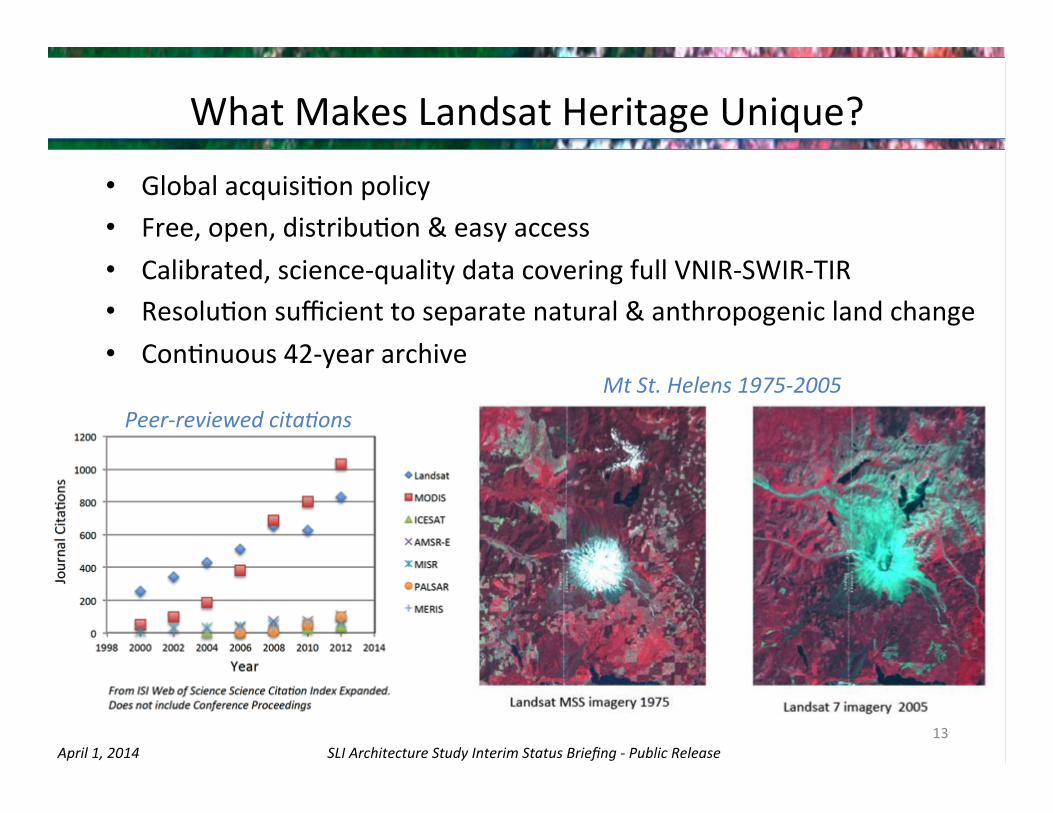
What Makes Landsat Heritage Unique?
• Global acquisiOon policy • Free, open, distribuOon & easy access • Calibrated, science-‐quality data covering full VNIR-‐SWIR-‐TIR • ResoluOon sufficient to separate natural & anthropogenic land change • ConOnuous 42-‐year archive
13
Peer-‐reviewed citaCons Mt St. Helens 1975-‐2005

SLI Architecture Study Interim Status Briefing -‐ Public Release April 1, 2014
3. USGS USER NEEDS ASSESSMENT Jim Nelson
14

SLI Architecture Study Interim Status Briefing -‐ Public Release April 1, 2014
Basic Spectral, Temporal, SpaOal
ProperOes
Level 1
Level 2
Level 3
User Data Needs Program/Mission Requirements
Data Quality, CalibraOon
Framework for AST User Needs Assessment
15
ElicitaOon from End Users
Landsat Science Team
Parametric Studies
Historical Performance

SLI Architecture Study Interim Status Briefing -‐ Public Release April 1, 2014
USGS NaOonal Land Imaging Requirements Project
• President’s FY12 budget request include language for the USGS for “understanding Federal land imaging requirements”
– IniOated NaOonal Land Imaging Requirements Project
• Two components: – User Requirements ElicitaJon
• All US land imaging needs • Repeatable and transparent process • Traceability of requirements via value tree
– System Development: Earth ObservaOon Requirements EvaluaOon System (EORES)
• Repository for requirements & capabiliOes informaOon • AnalyOcal tools • Joint development with NOAA (Atmosphere & Ocean)
• NLIR Moderate ResoluOon Pilot Project (Jun-‐Dec 2013) – Purpose was to test the requirements elicitaOon
methodology, process, and tools – Provided representaOve sample of applicaOons/requirements
which use moderate resoluOon imagery to support near-‐term mission-‐formulaOon efforts
– Focus on applicaOons using moderate resoluOon imagery (5-‐120 m resoluOon)
16

SLI Architecture Study Interim Status Briefing -‐ Public Release April 1, 2014
CharacterizaOon of End User Needs • Land Imaging user needs derived from targeted elicitaOons of Land Imaging user
community – NaOonal Land Imaging Requirements (NLIR) moderate resoluOon pilot project – Landsat ApplicaOons Requirements assessment for the 2012 USGS RFI – Landsat Science Team applicaOon assessment – Resulted in 151 disOnct, representaOve user applicaOons where Landsat data are used rouOnely
to produce and provide consistent services or informaOonal products • Government and university applicaOon sources elicited include:
– Bureau of Indian Affairs – Bureau of Land Management – Bureau of ReclamaCon – Fish and Wildlife Service – NaConal Park Service – Office of Surface Mining – State Government (Ohio & Western States EvapotranspiraCon) – UniversiCes (Idaho, Maryland) – U.S. Department of Agriculture (ARS, FAS, FS, FSA, NASS, NRCS, RMA) – USGS – NASA
• Six of the nine NEO Societal Benefit Areas (SBA’s) are addressed – These include: – (1) Agriculture & Forestry, (2) Climate, (3) Disasters, (4) Ecosystems, (5) Energy & Mineral
Resources, and (6) Water Resources • Note: ComparaOve importance of user applicaOons not assessed
17

SLI Architecture Study Interim Status Briefing -‐ Public Release April 1, 2014
Land Imaging User Needs StaOsOcs • SpaOal resoluOon
– Majority of rouOne user applicaOons require 30m for VSWIR, 120m for TIR
• Spectral Coverage – User applicaOons clearly rely
heavily on aggregated band combinaOons
– Very few visible spectra only (or VNIR only) applicaOons were idenOfied
– Simultaneous VSWIR and TIR measurement provide significantly more value than each measurement individually
• Revisit Rate – User need for increased revisit
rates clearly evident with 70% of applicaOons requiring ≤ 8 day revisit
– Revisit rate of 16 days saOsfies less than 40% of user applicaOons
18

SLI Architecture Study Interim Status Briefing -‐ Public Release April 1, 2014
Historical Landsat CapabiliOes Full Spectrum Coverage
Global AcquisiJon Global DistribuJon
19

SLI Architecture Study Interim Status Briefing -‐ Public Release April 1, 2014
Historical Availability – Calculated Reliability
20
8-‐Day Repeat
Actual Capability 100% 74%Predicted with Study Life 85% 32%Predicted with Actual Life 81% 27%
16-‐Day Repeat
L1
L2
L3
L4
L5
L6
L7
L8
Thresholds for value metrics

SLI Architecture Study Interim Status Briefing -‐ Public Release April 1, 2014
User Needs to Value Metrics • Land Imaging user needs cover needs of the US Land Imaging community
– Landsat provides the foundaOon for a US land imaging capability and provides the most criOcal subset of capabiliOes required to meet the needs of the user community (70% of user applicaOons surveyed)
• SystemaOc global coverage, 8 day revisit rate (16 day per satellite) of well-‐calibrated VNIR/SWIR/TIR coverage
– Some users require capabiliOes beyond what Landsat has tradiOonally provided (e.g., higher revisit rate, smaller GSD, more spectral coverage)
• Users to date have either purchased data to augment Landsat, proceeded with a reduced capability with reduced uOlity, or developed alternaOve methods for their applicaOons
• AST Value Metrics are based on historical availability (Landsat conOnuity) rather than Land Imaging User Needs (NLIR) data – Full spectrum, global acquisiOon and distribuOon (required of all architectures) – Historical availability of 8-‐day (baseline) and 16-‐day (threshold) revisit rate
21

SLI Architecture Study Interim Status Briefing -‐ Public Release April 1, 2014
4. IMAGING PERFORMANCE CHARACTERISTICS
Jeff Masek
22

SLI Architecture Study Interim Status Briefing -‐ Public Release April 1, 2014
LST DefiniOon of ConOnuity The USGS-‐NASA Landsat Science Team defines Landsat data conOnuity as the collecOon, archival, and distribuOon of image data of the Earth’s conOnents and surrounding coastal regions with the content, quality and coverage needed to map, monitor and assess the Earth’s characterisOcs and its response to natural and human-‐induced change. To accomplish this, conOnuity includes: • Long-‐term calibrated measurements that are consistent across the
changing instrument record. • A conOnuous record since the iniOaOon of observaOons with no significant
temporal or geographic data gaps. • Measurements that enable backward and forward assessments of the
condiOons and changes in the Earth’s surface. • Measurements with comparable spectral, spaOal, temporal, and
geographic properOes that result in sufficiently consistent and accurate documentaOon of surface characterisOc and dynamics. See “USGS-‐NASA Landsat Science Team Statement of Landsat ConCnuity: PrioriCes for a Future Land Imaging Architecture for Sustained Landsat ObservaCons” (January 23, 2014)
23

SLI Architecture Study Interim Status Briefing -‐ Public Release April 1, 2014 24
Performance RaJonale Spectral coverage across VNIR, SWIR, and Thermal IR (TIR)
• Most applicaCons require mulCple spectral regions (68% of NLIR applicaCons require SWIR; 34% require TIR)
30m VSWIR spaOal resoluOon 120m TIR spaOal resoluOon (60 m preferred)
• SpaCal resoluCon supports land management, land use, and ecosystem studies;
• Broad area coverage supports regional/conCnental monitoring
Ability to image each point on the globe every 16 days (8 days preferred)
• Time series needed to characterize seasonal change • More frequent observaCons help miCgate cloud cover
Sun-‐synchronous orbit, 10 AM crossing Ome (+/-‐ 30min)
• Radiometric consistency for interannual mapping of change; conCnuity with exisCng Landsat record
Near co-‐incident imaging of spectral bands (VSWIR within seconds; TIR within minutes of VSWIR)
• Near-‐simultaneous VSWIR required for mulC-‐band indices; • TIR and VSWIR coincidence supports ET, water resources applicaCons
Global coverage of land area • Required for global land science & applicaCons Less than 5% uncertainty in absolute spectral radiance
• Provides radiometric conCnuity for long-‐term monitoring and change detecCon
View angles < +/-‐ 15 degrees • Limit BRDF variability within archive
Free and open data distribuOon • Hallmark of Landsat program
Key Performance Aspects
See “USGS-‐NASA Landsat Science Team Statement of Landsat ConCnuity: PrioriCes for a Future Land Imaging Architecture for Sustained Landsat ObservaCons” (January 23, 2014)

SLI Architecture Study Interim Status Briefing -‐ Public Release April 1, 2014
Driving Parameters: Why are they CriOcal?
• Sun-‐synchronous orbit • View Angle < +/-‐ 15 degrees • VSWIR & TIR band simultaneity • Band co-‐registraOon • Radiometric calibraOon, uniformity, stability
25

SLI Architecture Study Interim Status Briefing -‐ Public Release April 1, 2014
Orbit Geometry
• Sun-‐synchronous geometry criOcal for VSWIR bands – Required for consistent illuminaOon for inter-‐annual change detecOon – Common requirement among all naOonal and commercial moderate-‐resoluOon
opOcal systems (MODIS, VIIRS, SenOnel-‐2, DMC, etc…) – Mid-‐morning to be compaOble with the Landsat archive
• Also desirable for TIR / EvapotranspiraOon (ET) applicaOons – Same Ome of day useful for consistent thermal state – Morning observaOons desirable for cloud cover, energy balance models
• Eliminates low inclinaOon orbits, including ISS as operaOonal plazorm – Low inclinaOon orbits for TIR remain interesOng for parOcular research
purposes
26

SLI Architecture Study Interim Status Briefing -‐ Public Release April 1, 2014
!12$
!8$
!4$
0$
4$
8$
12$
!30$ !20$ !10$ 0$ 10$ 20$ 30$View%Zenith%Angles%(degrees)%
NIR%band%(solar%zenith=45°)% corn$
soybean$
co2on$
wheat$
grass$
shrub$
soil$
aspen$
spruce$
pine$
!3#
!2#
!1#
0#
1#
2#
3#
!30# !20# !10# 0# 10# 20# 30#View%Zenith%Angles%(degrees)%
red%band%(solar%zenith=45°)% corn#
soybean#
co0on#
wheat#
grass#
shrub#
soil#
aspen#
spruce#
pine#
View Geometry Δ
Refl
ectance (%
)
• DirecOonal reflectance changes substanOally with view angle (BRDF), with variaOons becoming acute for > ~ +/-‐ 20 degrees
• Mixing a range of FOV’s can add “noise” to spectral Ome series • Landsat ST has recommended restricOng view angle to < +/-‐ 15 degrees
(current Landsat is +/-‐ 7.5 degrees) • Wider swath width suggested by NAS Study “Landsat and Beyond”
Gao et al., 2014, Angular Effects and CorrecCon for Medium ResoluCon Sensors to Support Crop Monitoring, in press JSTARS
Landsat
AWIFS AWIFS
Landsat
27

SLI Architecture Study Interim Status Briefing -‐ Public Release April 1, 2014
Band Simultaneity
• VSWIR bands should be collected within a few seconds – MulO-‐band indices need to “see” the same atmosphere for accuracy
• Simultaneity between TIR & VSWIR depends on applicaOon – Cloud screening requires all bands within seconds
• VSWIR-‐only cloud algorithms exist • But… “smearing” of clouds from non-‐simultaneous acquisiOon decreases usable data within each image
– Hydrodynamics (water resources) requires bands within minutes – EvapotranspiraOon requires data within hours or longer – Landsat Science Team prefers TIR and VSWIR data acquired at once
(ie. within seconds)
• Current AST architectures assumed: – TIR & VSWIR collecOon within one minute
28

SLI Architecture Study Interim Status Briefing -‐ Public Release April 1, 2014
Band-‐to-‐Band RegistraOon
• MisregistraOon of less than 0.20 pixels typically required for accurate (<10% error) mulO-‐band indices & change detecOon (Townshend et al., 1992, IEEE Trans. Geosci. and Remote Sens.)
• Current L8 Spec is: – 4.5m (LE90) or 0.15 VSWIR pixel within VSWIR bands – 30m (LE90) or 0.25 TIR pixel between TIR and VSWIR – Relaxed relaOve to L7 performance of ~0.08 pixel within VSWIR
• Admits disaggregated architectures, but… – Requires Oght poinOng knowledge and/or ground processing to register bands – Requires VSWIR registraOon band for TIR free-‐flyer
• Combined, the B2B registraOon and band simultaneity requirements drive implementaOons to not disaggregate reflecOve bands between separate spacecrab
29

SLI Architecture Study Interim Status Briefing -‐ Public Release April 1, 2014
Radiometric CharacterisOcs
Radiometry should be: • Stable – Allows trends in land condiOon to be tracked within seasons (e.g.
crop phenology) and across decades (e.g. climate impacts, ecologic change) – Short term radiometric stability is probably a greater design driver than
absolute accuracy: 0.5% over 60 sec; 1% over 16 days; 2% over 5 years
• Uniform – Allows consistent, automated mapping of land cover across broad areas. Requires: – Tight control of spectral bandpass across FOV’s
• Telecentric opOcs (and/or compensaOon) & careful selecOon of filters
– Instrument thermal control
• Calibrated to radiance, reflectance – CriOcal for long-‐term science applicaOons of the data set – IntegraOon with other data sets (e.g. MODIS, VIIRS, internaOonal sensors) – Retrieval of physical parameters (temperature, vegetaOon indices) – Fundamental reference for consistent, long-‐term archive
30

SLI Architecture Study Interim Status Briefing -‐ Public Release April 1, 2014 31
Gradual Canopy Change in Four-‐Corners Region of US Southwest

SLI Architecture Study Interim Status Briefing -‐ Public Release April 1, 2014 32
Vogelmann et al., Monitoring gradual ecosystem change using Landsat Cme series analysis: case studies in selected forest and rangeland ecosystems , Remote Sens. Environ, 2012
Long-‐term CalibraOon Required to Measure Long-‐term Changes

SLI Architecture Study Interim Status Briefing -‐ Public Release April 1, 2014
On-‐board CalibraOon • Provision of on-‐board calibraOon (e.g. solar diffuser) provides several important capabiliOes:
– Ability to flat-‐field detectors (ie. characterize Per-‐Pixel Uniformity) – Tie to absolute reflectance standard via lab-‐measured diffuser – Ability to assess stability as oben as needed (not just once-‐per-‐cycle)
• EssenOal for both VSWIR and TIR • SWIR and TIR parOcularly sensiOve to baseline (bias) drib
• It may be possible to obtain some of these capabiliOes without on-‐board calibraOon using vicarious or PICS (Pseudo-‐invariant CalibraOon Sites)
– Flat-‐fielding via side slither or global averages – Stability at ~monthly Ome scales using PICS (but need stable instrument over shorter intervals) – Absolute calibraOon via vicarious campaigns or sensor cross-‐calibraOon (but which sensors?)
• The Landsat CalibraOon Team will report back within a year on the efficacy of relying on PICS approaches for absolute calibraOon
– For now, all AST instrument concepts nominally include a single solar diffuser and sOmulaOon lamps – Landsat has historically been the backbone for cross-‐calibraOng the global moderate-‐resoluOon
constellaOon
• Removing on-‐board hardware increases the need for inherent radiometric stability and uniformity, which remain instrument design drivers.
– Difficult to evaluate instrument stability pre-‐launch
33

SLI Architecture Study Interim Status Briefing -‐ Public Release April 1, 2014
Parametric Studies
• AST and the Landsat Science Team are using parametric studies to refine established land imaging requirements – Are there driving requirements that could be relaxed? – What is the science and applicaOons impact of relaxing requirements?
• Ongoing studies
– What VSWIR SNR is required for land cover classificaOon, biophysical retrievals? • Improved SNR was #1 priority of Landsat-‐7 Science Team circa-‐2000 due to saturaOon of
TM & ETM+ data over snow, deserts, and poor radiometric resoluOon for dark targets • OLI SNR surpasses current requirements by 2-‐3X • LST degraded OLI data to obtain ETM+-‐ & OLI-‐required SNR • OLI required SNR shows substanOal benefits; OLI SNR performance less criOcal
– What image acquisiOon frequency is required for seasonal, cloud-‐free views? • MODIS cloud cover data used to model probability of obtaining clear view • 8-‐day coverage required to obtain clear view over Eastern US with >80% Ps
– VSWIR vs. TIR Ome separaOon for ET modeling – OLI aliasing requirements – Spectral uniformity, stray light
34

SLI Architecture Study Interim Status Briefing -‐ Public Release April 1, 2014
5. REPRESENTATIVE INSTRUMENT CONCEPTS
Phil Dabney
35

SLI Architecture Study Interim Status Briefing -‐ Public Release April 1, 2014
Near-‐Term Satellites Under ConsideraOon • Requirements driven
– Full spectral coverage VNIR, SWIR, TIR – 30m (120m) spaOal resoluOon VSWIR (TIR) – Threshold 16 day coverage; Historical baseline 8 day coverage – Global land coverage
• ExisOng / proven technology for near-‐term implementaOon – L8 clone – New design built to L8 requirements – TIR only gap filler
• Launch availability & cost – New launch opOons affect trade space
36

SLI Architecture Study Interim Status Briefing -‐ Public Release April 1, 2014
Instrument Point Designs • The AST invesOgated near-‐term full-‐capability point designs to span the trade
space with high fidelity well understood data points – Enough detail exists or was obtained to provide credible cosOng and system level
impacts on space crab and launch vehicles. – These ranged across tradiOonal L-‐8 clones, modified “clones”, to newer smaller
designs
• These point designs were developed, drawing on informaOon from – RFI responses – L-‐8 government instrument team – Past land imager and mission design studies funded by NASA – AST directed studies held at both GSFC and JPL using their instrument design labs
• RepresentaOve instrument concepts were established to span a broad parametric trade space – AST has high confidence that concepts will saOsfy Landsat-‐quality image
requirements
37

SLI Architecture Study Interim Status Briefing -‐ Public Release April 1, 2014
Instrument Point Designs – cont. • The designs span a large parameter space
– Total mass with the current OLI+TIRS at 650 kg down to the small full-‐spectrum payload at 150kg
– Volumes ranging from to 7 m3 down to 0.7 m3
– Swath width of 15 degrees (16-‐day repeat) to 30 degrees (8-‐day repeat)
• Instrument concepts used in architecture modeling studies – Landsat 8 Clone instruments
• OLI Clone • TIRS Clone
– Smaller VSWIR instrument • A smaller reflecOve band pushbroom imager similar to EO-‐1/ALI using well established
detector technologies – Smaller TIR instrument
• A smaller thermal imager representaOve of several known concepts – Small full-‐spectrum 15 deg. swath payload (VSWIR + TIR)
• AST concept was a single scanning instrument • Could be scanner, pushbroom, or mulOple refractor
– Small full-‐spectrum 30 deg. swath payload (VSWIR + TIR) • AST concept was a single scanning instrument • Could be scanner, pushbroom, or mulOple refractor
38

SLI Architecture Study Interim Status Briefing -‐ Public Release April 1, 2014
Longer-‐Term Satellites Under ConsideraOon • PotenOal future direcOons
– Smaller satellites and imagers • Mini-‐Sats (100-‐200kg) have most mid-‐term promise
– The ESPA ring class assume rides to 10 AM polar orbit are available • Micro-‐/nano-‐/cubesats require addiOonal technology development
– Hyperspectral • Could provide addiOonal science for future Land Imaging
• AST invesOgaOons – Explored technical challenges of smaller satellite concepts outlined in RFIs – AST instrument design sessions
• JPL Architecture Team session on range of small-‐sats to cubesats • Ongoing analysis of possible soluOons
– Exploring hyperspectral implementaOon • SimulaOng Landsat VSWIR data based on AVIRIS to compare with Landsat 8 OLI • InvesOgaOon of hyperspectral instrument risks and advantages
• Technology roadmap – Addressing specific technologies and direcOons for investment – Assumes some level of technology infusion from SLI program
39
SLI Architecture Study Interim Status Briefing -‐ Public Release April 1, 2014
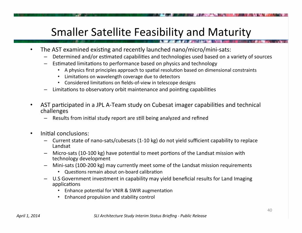
Smaller Satellite Feasibility and Maturity • The AST examined exisOng and recently launched nano/micro/mini-‐sats:
– Determined and/or esOmated capabiliOes and technologies used based on a variety of sources – EsOmated limitaOons to performance based on physics and technology
• A physics first principles approach to spaOal resoluOon based on dimensional constraints • LimitaOons on wavelength coverage due to detectors • Considered limitaOons on fields-‐of-‐view in telescope designs
– LimitaOons to observatory orbit maintenance and poinOng capabiliOes
• AST parOcipated in a JPL A-‐Team study on Cubesat imager capabiliOes and technical challenges
– Results from iniOal study report are sOll being analyzed and refined
• IniOal conclusions: – Current state of nano-‐sats/cubesats (1-‐10 kg) do not yield sufficient capability to replace
Landsat – Micro-‐sats (10-‐100 kg) have potenOal to meet porOons of the Landsat mission with
technology development – Mini-‐sats (100-‐200 kg) may currently meet some of the Landsat mission requirements
• QuesOons remain about on-‐board calibraOon – U.S Government investment in capability may yield beneficial results for Land Imaging
applicaOons • Enhance potenOal for VNIR & SWIR augmentaOon • Enhanced propulsion and stability control
40
SLI Architecture Study Interim Status Briefing -‐ Public Release April 1, 2014
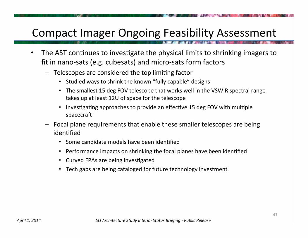
Compact Imager Ongoing Feasibility Assessment • The AST conOnues to invesOgate the physical limits to shrinking imagers to
fit in nano-‐sats (e.g. cubesats) and micro-‐sats form factors – Telescopes are considered the top limiOng factor
• Studied ways to shrink the known “fully capable” designs • The smallest 15 deg FOV telescope that works well in the VSWIR spectral range
takes up at least 12U of space for the telescope • InvesOgaOng approaches to provide an effecOve 15 deg FOV with mulOple
spacecrab
– Focal plane requirements that enable these smaller telescopes are being idenOfied
• Some candidate models have been idenOfied • Performance impacts on shrinking the focal planes have been idenOfied • Curved FPAs are being invesOgated • Tech gaps are being cataloged for future technology investment
41

SLI Architecture Study Interim Status Briefing -‐ Public Release April 1, 2014
6. ARCHITECTURE ASSESSMENT PROCESS
Tony Freeman
42

SLI Architecture Study Interim Status Briefing -‐ Public Release April 1, 2014
Process Overview • AST has a~empted to map the prime study tenets of Sustainability,
ConOnuity, and Reliability into our metrics and assessment process • SaOsfacOon of user community needs is reflected by comparison to
historical Landsat capabiliOes – Secondary metrics are being assessed to address the degree to which
architectures saOsfy other user desires
• AST process has evolved into a phased sequence to enable first phase assessment of many architectures followed by more detailed assessment of down-‐selected subsets
• Technical flight system concepts are first mapped to select business models to establish mission cost building blocks
• Missions are implemented as frequently as possible, constrained by the program budget profile
• Architecture performance as measured by availability and other metrics are then assessed
43

SLI Architecture Study Interim Status Briefing -‐ Public Release April 1, 2014
Three Basic Study Tenets for the Program (from AST Kickoff)
• Sustainability – The LI program should provide the data products for the long haul, without extraordinary infusions of funds, within the budget guidance provided.
• ConOnuity – The LI program should conOnue the long term Landsat data record. This does not necessarily mean the imagery per se, but the usable products that define the uOlity of the data record.
• Reliability – The LI program should be robust and not suscepCble to single point failures. The loss of a single satellite or instrument on orbit should not cripple the program or significantly impact users.
44

SLI Architecture Study Interim Status Briefing -‐ Public Release April 1, 2014
Architecture Assessment Starts with Concept DefiniOon
Concept 2
Cost/ Schedule
Architectures
Funding Profiles
Availability Concept n
Concept 1
Arch #X
Arch #Z Arch #Y
Assumes that the cost of all
architectures “fill up the wedge”
of available budget
“Sustainability”
“ConOnuity”
0%
100%
100%
• Based on reliability staOsOcs of chosen development class and on-‐orbit assets
• Design to Budget: Due to fixed annual program budget ceiling, schedule is the dependent variable
45
8-‐Da
y Av
ailability (FY19-‐FY38)
16-‐Day Availability (FY19-‐FY38)
“Reliability”
• AST considered over 600 architecture combinaOons

SLI Architecture Study Interim Status Briefing -‐ Public Release April 1, 2014
Cost & Schedule Assessment Overview
• Standard Aerospace Independent Cost & Schedule EsOmate (ICE/ISE) methodology used − Similar to process employed for Decadal Survey Process − Launch Vehicle cost provided by KSC LSP
• CosOng & Schedule based on analogies within Mission Class − Class B analogies include Directed Earth Science spacecrab & instruments − Class C analogies include ESSP and MIDEX class spacecrab & instruments − Class D assumed include small LEO Earth Science and SMEX class spacecrab & instruments
• AssumpOons made relaOve to potenOal savings due to commercial pracOces
− Savings show potenOal reducOon although final risk assessment of uOlizing different pracOces has not been conducted
• Constrained budget requires that some missions to be stretched to fit budget − Varies as a funcOon of the annual funding requirements for each mission
46

SLI Architecture Study Interim Status Briefing -‐ Public Release April 1, 2014
0%
10%
20%
30%
40%
50%
60%
70%
80%
90%
100%
2015 2016 2017 2018 2019 2020 2021 2022 2023 2024 2025 2026 2027 2028 2029 2030 2031 2032 2033 2034 2035 2036 2037 2038
16-‐Day Rep
eat A
vailability
Class B-‐Gov
VSWIR Only 16-‐Day Availability
TIR Only 16-‐Day Availability
Full System 16-‐Day Availability
LRD
Average 16-Day Availability 2019-2038 = 80.4%
Average 16-Day Availability 2019-2028 = 73.4%
Average 16-Day Availability 2029-2038 = 87.3%
Minimum Availability = 50.5%
Maximum Availability = 97.4%
Class B-Gov Full System Availability Overview
0%
10%
20%
30%
40%
50%
60%
70%
80%
90%
100%
2015 2016 2017 2018 2019 2020 2021 2022 2023 2024 2025 2026 2027 2028 2029 2030 2031 2032 2033 2034 2035 2036 2037 2038
16-‐Day Rep
eat A
vailability
Class B-‐Gov
VSWIR Only 16-‐Day Availability
TIR Only 16-‐Day Availability
Full System 16-‐Day Availability
LRD
Average 16-Day Availability 2019-2038 = 91.2%
Average 16-Day Availability 2019-2028 = 86.5%
Average 16-Day Availability 2029-2038 = 95.9%
Minimum Availability = 61%
Maximum Availability = 99.2%
Class B-Gov Full System Availability Overview
Example of “Sustainability” Impact • Design to Budget: Due to fixed annual program budget ceiling, schedule is the
dependent variable • This affects the launch cadence and overall system availability.
Prior to Fi�ng Budget Aber Fi�ng Budget
Budget
Availability
Fewer Launches
Bigger Gap
47
SLI Architecture Study Interim Status Briefing -‐ Public Release April 1, 2014
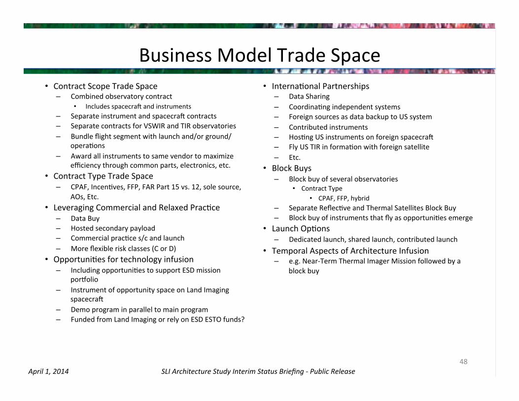
Business Model Trade Space
48
• Contract Scope Trade Space – Combined observatory contract
• Includes spacecrab and instruments – Separate instrument and spacecrab contracts – Separate contracts for VSWIR and TIR observatories – Bundle flight segment with launch and/or ground/
operaOons – Award all instruments to same vendor to maximize
efficiency through common parts, electronics, etc. • Contract Type Trade Space
– CPAF, IncenOves, FFP, FAR Part 15 vs. 12, sole source, AOs, Etc.
• Leveraging Commercial and Relaxed PracOce – Data Buy – Hosted secondary payload – Commercial pracOce s/c and launch – More flexible risk classes (C or D)
• OpportuniOes for technology infusion – Including opportuniOes to support ESD mission
porzolio – Instrument of opportunity space on Land Imaging
spacecrab – Demo program in parallel to main program – Funded from Land Imaging or rely on ESD ESTO funds?
• InternaOonal Partnerships – Data Sharing – CoordinaOng independent systems – Foreign sources as data backup to US system – Contributed instruments – HosOng US instruments on foreign spacecrab – Fly US TIR in formaOon with foreign satellite – Etc.
• Block Buys – Block buy of several observatories
• Contract Type • CPAF, FFP, hybrid
– Separate ReflecOve and Thermal Satellites Block Buy – Block buy of instruments that fly as opportuniOes emerge
• Launch OpOons – Dedicated launch, shared launch, contributed launch
• Temporal Aspects of Architecture Infusion – e.g. Near-‐Term Thermal Imager Mission followed by a
block buy

SLI Architecture Study Interim Status Briefing -‐ Public Release April 1, 2014
Business Model Impact on Assessments • Annual budget constraints of Land Imaging program make choice of business model
especially important • First-‐order impacts of business models are reflected in architecture cost esOmates,
which then drive availability results • TradiOonal Class B separate procurement approaches (i.e., instruments developed &
GFE’d to a spacecrab contractor) provide the lowest risk implementaOon but at a higher cost
– Class C & D implementaOons are also being considered
• Targeted use of commercial pracOce may enable lower cost, long-‐life systems without significant increase in risk and deserves further consideraOon
– A representaOve business model Commercial PracOce Spacecrab & Launch (CPSL) is used that assumes
• Government-‐developed instruments via direct contract or in-‐house • Bundled spacecrab and launch deal that leans heavily on commercial pracOce
• AST sOll invesOgaOng block buy approaches • Business model cost impacts esOmated
based on analogy data
49
Gov’t Separate Contracts
Comm. PracJces S/C & LV
Class B $$$ $$
Class C $$ $$
Class D+ $ $

SLI Architecture Study Interim Status Briefing -‐ Public Release April 1, 2014
Value Metrics for the AST
• Consider four value characterisJcs: 1. Performance 2. Cost 3. Risk 4. Added Value
• Use three phases of screening: 1. First phase is intended to filter for architectures that provide conOnuity
and affordability, and are technically ready for implementaOon 2. Second phase compares architectures in terms of risk, robustness, and
added value 3. Third phase assess a small number of select architectures in more detail
50

SLI Architecture Study Interim Status Briefing -‐ Public Release April 1, 2014
Value Metrics for the AST – Phase 1
Phase I (Screening) • Technology Readiness –Technology Readiness Level (TRL) of the
instrument(s) for the first mission. TRL must be 5 or higher to be considered low risk for this study.
• Reliability Measure #1 (RM1) – staOsOcal availability* of 16-‐day coverage over architecture life. Threshold on RM1 was set to 81% based on historical Landsat program availability.
• Reliability Measure #2 (RM2) – staOsOcal availability* of 8-‐day coverage over architecture life. . Threshold on RM2 was set to 27% based on historical Landsat program availability.
* Availability calculated from historical post-‐launch reliability data
51

SLI Architecture Study Interim Status Briefing -‐ Public Release April 1, 2014
Reliability EOL AssumpOons • AST decided that criteria of 50% Probability of Success (Ps) should signify End of life
(EOL) for all candidates • Historical lifeOme results in 50% Ps for:
− New Concept Class B = 15 years − New Concept Class C = 11 years − New Concept Class D = 7 years
• Class B – 5 year design lifeOme – Fully redundant system – High quality parts – Full oversight & review program
• Class C – 3 year design lifeOme – SelecOve redundancy – Some relaxaOon on parts – Oversight & review program
• Class D – <2 year design lifeOme – Single string – Mix of part quality with some
screening – SubstanOally reduced insight &
reviews
52
0
0.1
0.2
0.3
0.4
0.5
0.6
0.7
0.8
0.9
1
0 1 2 3 4 5 6 7 8 9 10 11 12 13 14 15
DL < 2
DL= 2-‐5
DL >= 5
Class D EOL
= 7 years
Class C EOL
= 11 years
Class B EOL = ~15 years
End of Life (years)
Prob
ability of S
uccess

SLI Architecture Study Interim Status Briefing -‐ Public Release April 1, 2014
Historical Availability – Calculated Reliability
53
8-‐Day Repeat
Actual Capability 100% 74%Predicted with Study Life 85% 32%Predicted with Actual Life 81% 27%
16-‐Day Repeat
L1
L2
L3
L4
L5
L6
L7
L8
Thresholds for value metrics

SLI Architecture Study Interim Status Briefing -‐ Public Release April 1, 2014
Value Metrics for the AST – Phase 1 Screening
54
Phase 1 Screening Example (Availability):
8-day Threshold 16-day Threshold Architecture Architectures in the
yellow area may be considered for Phase 2
Architectures in the red area DO NOT pass Phase 1 screening
Architectures in the green area pass Phase 1 screening

SLI Architecture Study Interim Status Briefing -‐ Public Release April 1, 2014
Value Metrics for the AST – Phase 2 & 3
55
Phase 2 Metrics – used for comparison/ranking • Likely gap in availability (iniCal/total; 8, 16-‐day) • Date of full spectrum capability (US or Int’l) • Date of first US full spectrum capability • “Steady state” launch cadence • Launch failure: average 16-‐day availability with one launch failure • Launch failure: average 8-‐day availability with one launch failure • Schedule stretch: for precursor due to budget constraint • Schedule stretch: for “steady state” due to budget constraint • Ground systems / operaCons impacts (precursor and steady state) • Average Availability for 4-‐day
Phase 3 Metrics – used for comparison/ranking • Cost risk • Schedule risk • Technical risk • ImplementaCon approach risk • PotenCal for reduced costs to ESD • Technology infusion

SLI Architecture Study Interim Status Briefing -‐ Public Release April 1, 2014
Value Metrics for the AST – Phase 2 Screening
Phase 2 Screening Example:
56
Architecture IniJal 8-‐day Gap
(yrs)
Total 8-‐day Gap
(yrs)
Earliest F
ull
Spectrum
Ca
pability
First U
S Full
Spectrum
Ca
pability
Future Lau
nch
Cade
nce (yrs)
Precursor
Sche
dule Stretch
(yrs)
Average Stretch
per M
ission
for
Steady State (yrs)
Average RM
1 with
laun
ch
failu
re (%
) Av
erage RM
2 with
laun
ch
failu
re (%
) Groun
d System
s /
Ops Im
pacts –
First M
ission
Groun
d System
s /
Ops Im
pacts –
Steady State
Risk
Average
Availability for 4
-‐da
y Re
peat (%
)
Architecture 1 2024 2024 9 N/A N/A TBD 0
Architecture 2 2023 2028 4 TBD 15
Architecture 3 2021 2021 5 TBD 35
5
3
1
8
3
2
1
2
3
1
2
85
66
82
60
28
51
M
L
L
M
H
SLI Architecture Study Interim Status Briefing -‐ Public Release April 1, 2014
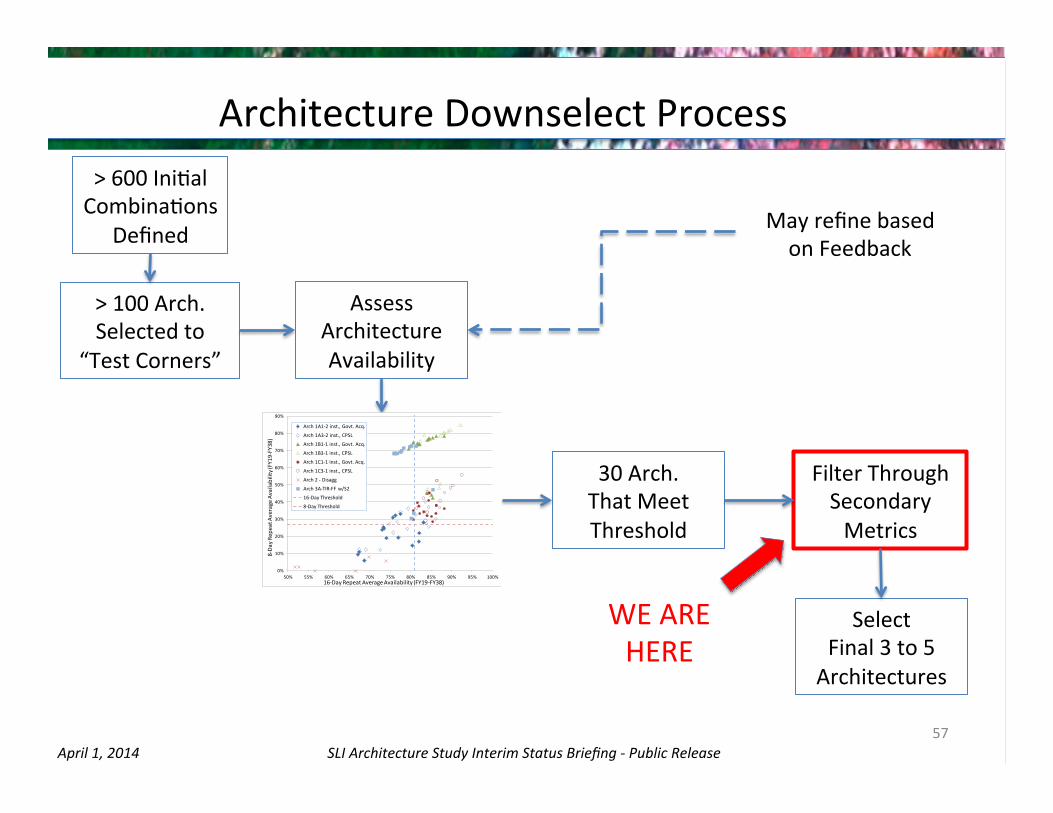
Architecture Downselect Process > 600 IniOal CombinaOons
Defined
> 100 Arch. Selected to
“Test Corners”
Assess Architecture Availability
30 Arch. That Meet Threshold
Select Final 3 to 5 Architectures
Filter Through Secondary Metrics
WE ARE HERE
May refine based on Feedback
57
0%
10%
20%
30%
40%
50%
60%
70%
80%
90%
50% 55% 60% 65% 70% 75% 80% 85% 90% 95% 100%
8-‐Da
y Rep
eat A
verage Availability (FY19-‐FY38)
16-‐Day Repeat Average Availability (FY19-‐FY38)
Arch 1A1-‐2 inst., Govt. Acq.
Arch 1A3-‐2 inst., CPSL
Arch 1B1-‐1 inst., Govt. Acq.
Arch 1B3-‐1 inst., CPSL
Arch 1C1-‐1 inst., Govt. Acq.
Arch 1C3-‐1 inst., CPSL
Arch 2 -‐ Disagg
Arch 3A-‐TIR-‐FF w/S2
16-‐Day Threshold
8-‐Day Threshold

SLI Architecture Study Interim Status Briefing -‐ Public Release April 1, 2014
7. SUMMARY OF INITIAL FINDINGS Evan Webb
58

SLI Architecture Study Interim Status Briefing -‐ Public Release April 1, 2014 59
What is an Architecture (for the purposes of this study)?
A unique combinaJon over the program lifeJme of: -‐ instrument payload -‐ spacecrab -‐ business model/procurement approach -‐ mission risk class -‐ organizaOonal partnerships -‐ launch opOon -‐ technology infusion plan -‐ precursor mission (opOonal)
-‐ could be L-‐8 clone, or other
Long-‐term configuraOon
Mission 1
(precursor) Mission 2
Mission 3
. . . Mission
1

SLI Architecture Study Interim Status Briefing -‐ Public Release April 1, 2014
Minisat/ Microsat
ConstellaJons
Architecture Trade Space
60
Space-‐based Systems
Launch Vehicle Instrument ConfiguraJon
Spacecrad Plaeorm
Dedicated
Shared
PotenJal Technology Infusion
Business Models Partnerships Risk Class
Class B
Class C
Class D+
InternaJonal
Commercial
Federal Agencies
Two Separate Instruments
Combined Instrument
3+ Separate Instruments Hyperspectral
Micro-‐bolometer
Enabling Instrument Technologies
Dedicated Spacecrad
Hosted Payload
Separate Contracts
Observatory Contract
Block Buys
Data Buy
Sole Source
IOO Space
Commercial PracJces SC + LV
Hands Off Turn-‐Key

SLI Architecture Study Interim Status Briefing -‐ Public Release April 1, 2014
0%
10%
20%
30%
40%
50%
60%
70%
80%
90%
50% 55% 60% 65% 70% 75% 80% 85% 90% 95% 100%
8-‐Da
y Rep
eat A
verage Availability (FY19-‐FY38)
16-‐Day Repeat Average Availability (FY19-‐FY38)
Arch 1A1-‐2 inst., Govt. Acq.
Arch 1A3-‐2 inst., CPSL
Arch 1B1-‐1 inst., Govt. Acq.
Arch 1B3-‐1 inst., CPSL
Arch 1C1-‐1 inst., Govt. Acq.
Arch 1C3-‐1 inst., CPSL
Arch 2 -‐ Disagg
Arch 3A-‐TIR-‐FF w/S2
16-‐Day Threshold
8-‐Day Threshold
Summary Availability for All Architectures
61

SLI Architecture Study Interim Status Briefing -‐ Public Release April 1, 2014
0%
10%
20%
30%
40%
50%
60%
70%
80%
90%
50% 55% 60% 65% 70% 75% 80% 85% 90% 95% 100%
8-‐Da
y Rep
eat A
verage Availability (FY19-‐FY38)
16-‐Day Repeat Average Availability (FY19-‐FY38)
Arch 1A1-‐2 inst., Govt. Acq.
Arch 1A3-‐2 inst., CPSL
Arch 1B1-‐1 inst., Govt. Acq.
Arch 1B3-‐1 inst., CPSL
Arch 1C1-‐1 inst., Govt. Acq.
Arch 1C3-‐1 inst., CPSL
Arch 2 -‐ Disagg
Arch 3A-‐TIR-‐FF w/S2
16-‐Day Threshold
8-‐Day Threshold
Summary Availability for All Architectures
62
Disaggregated TIR & VSWIR sats

SLI Architecture Study Interim Status Briefing -‐ Public Release April 1, 2014
0%
10%
20%
30%
40%
50%
60%
70%
80%
90%
50% 55% 60% 65% 70% 75% 80% 85% 90% 95% 100%
8-‐Da
y Rep
eat A
verage Availability (FY19-‐FY38)
16-‐Day Repeat Average Availability (FY19-‐FY38)
Arch 1A1-‐2 inst., Govt. Acq.
Arch 1A3-‐2 inst., CPSL
Arch 1B1-‐1 inst., Govt. Acq.
Arch 1B3-‐1 inst., CPSL
Arch 1C1-‐1 inst., Govt. Acq.
Arch 1C3-‐1 inst., CPSL
Arch 2 -‐ Disagg
Arch 3A-‐TIR-‐FF w/S2
16-‐Day Threshold
8-‐Day Threshold
Summary Availability for All Architectures
63
L8-‐like sats with new instruments (not clones)

SLI Architecture Study Interim Status Briefing -‐ Public Release April 1, 2014
0%
10%
20%
30%
40%
50%
60%
70%
80%
90%
50% 55% 60% 65% 70% 75% 80% 85% 90% 95% 100%
8-‐Da
y Rep
eat A
verage Availability (FY19-‐FY38)
16-‐Day Repeat Average Availability (FY19-‐FY38)
Arch 1A1-‐2 inst., Govt. Acq.
Arch 1A3-‐2 inst., CPSL
Arch 1B1-‐1 inst., Govt. Acq.
Arch 1B3-‐1 inst., CPSL
Arch 1C1-‐1 inst., Govt. Acq.
Arch 1C3-‐1 inst., CPSL
Arch 2 -‐ Disagg
Arch 3A-‐TIR-‐FF w/S2
16-‐Day Threshold
8-‐Day Threshold
Summary Availability for All Architectures
64
TIR-‐Only Free-‐flyers with SenOnel-‐2 A,B,C,D

SLI Architecture Study Interim Status Briefing -‐ Public Release April 1, 2014
0%
10%
20%
30%
40%
50%
60%
70%
80%
90%
50% 55% 60% 65% 70% 75% 80% 85% 90% 95% 100%
8-‐Da
y Rep
eat A
verage Availability (FY19-‐FY38)
16-‐Day Repeat Average Availability (FY19-‐FY38)
Arch 1A1-‐2 inst., Govt. Acq.
Arch 1A3-‐2 inst., CPSL
Arch 1B1-‐1 inst., Govt. Acq.
Arch 1B3-‐1 inst., CPSL
Arch 1C1-‐1 inst., Govt. Acq.
Arch 1C3-‐1 inst., CPSL
Arch 2 -‐ Disagg
Arch 3A-‐TIR-‐FF w/S2
16-‐Day Threshold
8-‐Day Threshold
Summary Availability for All Architectures
65
Combined single-‐ swath instrument
SLI Architecture Study Interim Status Briefing -‐ Public Release April 1, 2014
0%
10%
20%
30%
40%
50%
60%
70%
80%
90%
50% 55% 60% 65% 70% 75% 80% 85% 90% 95% 100%
8-‐Da
y Rep
eat A
verage Availability (FY19-‐FY38)
16-‐Day Repeat Average Availability (FY19-‐FY38)
Arch 1A1-‐2 inst., Govt. Acq.
Arch 1A3-‐2 inst., CPSL
Arch 1B1-‐1 inst., Govt. Acq.
Arch 1B3-‐1 inst., CPSL
Arch 1C1-‐1 inst., Govt. Acq.
Arch 1C3-‐1 inst., CPSL
Arch 2 -‐ Disagg
Arch 3A-‐TIR-‐FF w/S2
16-‐Day Threshold
8-‐Day Threshold
Summary Availability for All Architectures
66
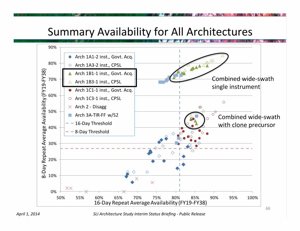
Combined wide-‐swath single instrument
Combined wide-‐swath with clone precursor

SLI Architecture Study Interim Status Briefing -‐ Public Release April 1, 2014
Example Result (1)
67
16-‐Day vs. 8-‐Day Availability – Architecture 1B1 (single satellite full spectrum wide swath), Class B
* Note: LRD = Launch Readiness Date, EOL = End of LifeOme
16-‐Day Availability 8-‐Day Availability
0%
10%
20%
30%
40%
50%
60%
70%
80%
90%
100%
2015 2016 2017 2018 2019 2020 2021 2022 2023 2024 2025 2026 2027 2028 2029 2030 2031 2032 2033 2034 2035 2036 2037 2038
16-‐Day Rep
eat A
vailability
Class B-‐ACMS
VSWIR Only 16-‐Day Availability
TIR Only 16-‐Day Availability
Full System 16-‐Day Availability
LRD
Average 16-Day Availability 2019-2038 = 88.2%
Average 16-Day Availability 2019-2028 = 79.9%
Average 16-Day Availability 2029-2038 = 96.4%
Minimum Availability = 57.3%
Maximum Availability = 99.2%
Class B-ACMS Full System Availability OverviewMission 1 LRD
Mission 2 LRD
Mission 3 LRD
0%
10%
20%
30%
40%
50%
60%
70%
80%
90%
100%
2015 2016 2017 2018 2019 2020 2021 2022 2023 2024 2025 2026 2027 2028 2029 2030 2031 2032 2033 2034 2035 2036 2037 2038
8-‐Da
y Av
ailability
Class B-‐ACMS
VSWIR Only 8-‐Day Availability
TIR Only 8-‐Day Availability
Full System 8-‐Day Availability
LRD
Average 8-Day Availability 2019-2038 = 78.6%
Average 8-Day Availability 2019-2028 = 60.7%
Average 8-Day Availability 2029-2038 = 96.4%
Class B-ACMS Full System Availability Overview
IniJal Gap
Mission 1 LRD
Mission 2 LRD
Mission 3 LRD

SLI Architecture Study Interim Status Briefing -‐ Public Release April 1, 2014
Example Result (2)
68
Without L8 Clone Precursor With L8 Clone Precursor
8-‐Day Availability – Architecture 1B1, class B, effect of L8 clone Precursor
0%
10%
20%
30%
40%
50%
60%
70%
80%
90%
100%
2015 2016 2017 2018 2019 2020 2021 2022 2023 2024 2025 2026 2027 2028 2029 2030 2031 2032 2033 2034 2035 2036 2037 2038
8-‐Da
y Av
ailability
Class B-‐ACMS + GF L8-‐Clone-‐Gov
VSWIR Only 8-‐Day Availability
TIR Only 8-‐Day Availability
Full System 8-‐Day Availability
LRD
Average 8-Day Availability 2019-2038 = 42.5%
Average 8-Day Availability 2019-2028 = 4.7%
Average 8-Day Availability 2029-2038 = 80.3%
Class B-ACMS Full System Availability Overview
Mission 2 LRD
Mission 3 LRD
IniJal Gap
Longer Gap
L8 TIRS EOL
L8 Clone LRD
0%
10%
20%
30%
40%
50%
60%
70%
80%
90%
100%
2015 2016 2017 2018 2019 2020 2021 2022 2023 2024 2025 2026 2027 2028 2029 2030 2031 2032 2033 2034 2035 2036 2037 2038
8-‐Da
y Av
ailability
Class B-‐ACMS
VSWIR Only 8-‐Day Availability
TIR Only 8-‐Day Availability
Full System 8-‐Day Availability
LRD
Average 8-Day Availability 2019-2038 = 78.6%
Average 8-Day Availability 2019-2028 = 60.7%
Average 8-Day Availability 2029-2038 = 96.4%
Class B-ACMS Full System Availability Overview
IniJal Gap
Mission 1 LRD
Mission 2 LRD
Mission 3 LRD
The clone precursor takes a long Cme to develop due to schedule stretch, and then delays LRD #2 as well, likely causing 8-‐day coverage gaps.

SLI Architecture Study Interim Status Briefing -‐ Public Release April 1, 2014
HypotheOcal Future Small Satellite CapabiliOes
• The AST put together a “what-‐if” scenario that assumed potenOal future small satellites with fully capable instruments could be developed in small (50 kg, 100W) constraints to fit within ESPA class (~180 kg) system
– Assumed characterisOcs beyond current state of the art for Landsat-‐like imaging performance
• Two noOonal concepts idenOfied allowing 2 spacecrab to be launched on single ESPA ring
– SSa: 2 Separate Instruments on Separate Spacecrab • One containing an instrument meeOng VSWIR requirements • One with instrument meeOng TIR requirements
– SSb: 2 Separate Spacecrab launching Full Spectrum Combined Instrument • Provides 2 spacecrab in orbit simultaneously provides consistent 8-‐day repeat
• Low cost allows for 2-‐year centers in launches for large constellaOon of spacecrab
• AST recognizes that some technology investment is needed to enable these capabiliOes
69

SLI Architecture Study Interim Status Briefing -‐ Public Release April 1, 2014
0%
10%
20%
30%
40%
50%
60%
70%
80%
90%
100%
50% 55% 60% 65% 70% 75% 80% 85% 90% 95% 100%
8-‐Da
y Rep
eat A
verage Availability (FY19-‐FY38)
16-‐Day Repeat Average Availability (FY19-‐FY38)
Arch 2-‐Future Small Sats
Arch 2 -‐ Disagg
16-‐Day Threshold
8-‐Day Threshold
Future Small Satellite Results: Arch 2
70
Future Small Sats Improve
Disaggregated Case

SLI Architecture Study Interim Status Briefing -‐ Public Release April 1, 2014
0%
10%
20%
30%
40%
50%
60%
70%
80%
90%
100%
55% 60% 65% 70% 75% 80% 85% 90% 95% 100%
Average 8-‐Da
y Re
peat Availability (FY1
9-‐FY38
)
Average 16-‐Day Repeat Availability (FY19-‐FY38)
Arch1 Future Small Sats
Arch 1B1-‐1 inst., Govt. Acq.
Arch 1A1-‐2 inst., Govt. Acq.
16-‐Day Threshold
8-‐Day Threshold
Future Small Satellite Results: Arch 1
71
Future Small Sats Improve
Architecture 1 Results

SLI Architecture Study Interim Status Briefing -‐ Public Release April 1, 2014
ObservaOons (1)
• The SLI program budget profile is the dominant driver of the architecture trade space
• AST has idenOfied viable architectures within the constraints of the study – However, those approaches that saOsfy the value metrics have their own
unique drawbacks and risks • Landsat 8–like Class B satellites with two instruments, while perhaps lower in technical risk, tend to be expensive and don’t fit well in this program budget
• TIR-‐only satellites and internaOonal partnerships, while lower in cost, rely on foreign systems to conOnue the U.S. historical Landsat archive
• A single satellite with double swath coverage (achievable by a scanner, mulOple telescopes, etc.), could provide very good performance along with reduced program cost, but may come with some developmental risk
72
SLI Architecture Study Interim Status Briefing -‐ Public Release April 1, 2014
ObservaOons (2) • Architectures that disaggregate reflecOve band imagers and thermal
imagers onto separate satellites does not perform well in the metrics due to inherent inefficiency – Budget profile restricts launch rate to maintain high full-‐spectrum availability – Future small, lower-‐cost satellites with reduced launch costs may improve
performance of this approach
• A “Landsat-‐8 clone” precursor mission would be a proven performer to maintain very high quality observaOons, but is expensive enough that launch will be delayed (due to “schedule stretch”) to fit in the budget profile – Could be the precursor mission to any of the above approaches
• Future smallsats that could achieve all land imaging requirements in a small fully capable observatory can potenOally improve availability substanOally in a Oghtly constrained budget environment
73

SLI Architecture Study Interim Status Briefing -‐ Public Release April 1, 2014
8. REMAINING STUDY PLANS AND INDUSTRY PARTICIPATION
Del Jenstrom – AST Manager
74

SLI Architecture Study Interim Status Briefing -‐ Public Release April 1, 2014
AST Study Timeline & Milestones
75
Mar Apr May Jun Jul
2014
NASA Interim Report To Congress
Aug
Checkpoint Review
Community Forum
NASA Arch ImplementaOon Plan to OMB/OSTP
Mtgs. w/ Industry
AST Technology Infusion Studies
Final AST Products to ESD
Refinement of Architecture Trades Finalize Findings Report GeneraOon Support
Checkpoint Review
Landsat Science Team
Briefing

SLI Architecture Study Interim Status Briefing -‐ Public Release April 1, 2014
Industry Input to AST Studies • AST would like further industry input to complete studies
– Seek feedback regarding April 1 forum • Send wri~en input to hq-‐landimaging-‐[email protected]
– Comments on preliminary AST findings – Responses to AST quesOons (next slide)
– AST face-‐to-‐face meeOngs with industry and user representaOves • Provide personal forum for community input
– ~1 hour per visit • TentaOvely targeOng both west coast and east coast opportuniOes
– NASA/ARC: April 15, 16 – NASA/GSFC: April 29, 30, & May 1
• One visit per company, please • Request date/Ome via email to hq-‐landimaging-‐[email protected]
76

SLI Architecture Study Interim Status Briefing -‐ Public Release April 1, 2014
QuesOons For Industry • Technical Architectures
– How best to implement architectures that saOsfy the full set of requirements? – Do you have other architectures you don’t see represented in our studies?
• Business Models – How can block buys best be implemented under annual budget constraint?
• How much does first unit cost increase, and how much can be saved on future units? • How can a large cost peak be avoided?
– How best to reduce cost without unacceptable risk increase? • NASA Class A/B/C/D construct equates lower class with lower reliability & lifeOme • How can SLI Program gain the cost efficiencies of proven industry best pracOces that
can yield high-‐reliability, long-‐life systems, specifically with respect to spacecrab and launch services?
– For example, consider a business model where » Government provided instrument(s) are the prime payload
• Developed via direct contract or government in-‐house » Bundled contract for contractor provided/owned spacecrab and launch
• Developed under streamlined mission assurance requirements • Perhaps enables commercial secondary payloads
77

SLI Architecture Study Interim Status Briefing -‐ Public Release April 1, 2014
Q&A DISCUSSION All
78

SLI Architecture Study Interim Status Briefing -‐ Public Release April 1, 2014
Acronyms AST – Architecture Study Team ACMS – Advanced Combined MulOspectral Scanner AWiFS – Advanced Wide Field Sensor BPT – Baseline Performance Threshold BRDF – Bi-‐direcOonal Reflectance DistribuOon FuncOon CA – Cloud Aerosol (band) CBE – Current Best EsOmate CPAF – Cost Plus Award Fee CPIF – Cost Plus IncenOve Fee CPSL – Commercial PracOces Spacecrab & Launch DL – Design Life EOL – End of Life EROS -‐ Earth Resources ObservaOon and Science ESPA – EELV Secondary Payload Adapter ESTO – Earth Science Technology Office ET – EvapotranspiraOon ETM+ -‐ Enhanced ThemaOc Mapper Plus EV – Earth Venture FFP – Firm Fixed Price FPA – Focal Plane Assembly FOV – Field of View GSD – Ground Sample Distance HyspIRI – Hyperspectral Infrared Imager IDL – Integrated Design Lab LST – Landsat Science Team LDCM – Land Data ConOnuity Mission
LRD – Launch Readiness Date LV – Launch Vehicle MPT – Minimum Performance Threshold MSI – MulOspectral Instrument NEdT – Noise Equivalent delta Temperature NDVI – Normalized Difference VegetaOon Index NLIR – NaOonal Land Imaging Requirements OAP – Orbit Average Power OLI – OperaOonal Land Imager PHyTIR – Prototype HyspIRI Thermal Infrared Radiometer Ps – Probability of Success RM – Reliability Measure ROIC – Read-‐Out Integrated Circuit S2 – SenOnel-‐2 SLI – Sustainable Land Imaging SNR – Signal-‐to-‐Noise RaOo SSM – Scene Select Mirror ST – Science Team SWIR – Short Wave Infrared TDI -‐ Time Delay IntegraOon TIR – Thermal Infrared TIRS – Thermal Infrared Sensor TRL – Technology Readiness Level VNIR – Visible and Near Infrared VSWIR – Visible Shortwave Infrared
79