On the map projection of Rigas Velestinlis Charta (*)
15
e-Perimetron, Vol. 3, No. 3, 2008 [146-160] www.e-perimetron.org | ISSN 1790-3769 [146] Chryssoula Boutoura * On the map projection of Rigas Velestinlis Charta (*) Keywords: Rigas Velestinlis; Rigas Charta; Greek enlightenment; Eighteenth century cartography; map projections; Delisle map tradition. Summary The cartographic work of Rigas Velestinlis, the major figure of the Greek Enlightenment and an activist of the Greek Resurgence in the late eighteenth century, is not well known in the interna- tional cartographic literature, despite the fact that his masterpiece the twelve-sheet Charta (1797) is one of the most interesting cartographic products of the period. The few existing relevant refer- ences in the non-Greek bibliography, almost exclusively in French, describe Charta mainly as an intellectual work rather than a real cartographic product, from the scientific and technological points of cartographic view. This paper describes and explains for the first time an important con- stituent of Rigas Charta as it is the projection of the map and its framing of geographic meridians and parallels. Departing from the dominant at that time Delisle cartographic representation models (Delisle, 1700; Senex, 1721; Blair, 1768; Lotter, 1778; Delisle, 1794, et al.), the Delisle map pro- jection is implemented in the study of Rigas map proving that despite the fact that his Charta fol- lows the geographic content according to Delisle mapping parametrization, its graticule framing is erroneously traced deviating the Delisle’s relevant standard. Introduction Rigas Velestinlis is one of the major figures of Greek Enlightenment and a top activist of the Greek Re- surgence in the late eighteenth century 1 . A native of Thessaly, was born in Velestino (1757) and edu- cated at the neighbouring Ampelakia, a prosperous town pioneered an early cooperative experience 2 , before departing for his great patriotic adventure during a short life ended with his assassination at Bel- grade in 1798. Spending some time in Holy Mount Athos and Constantinople, he established in Bucha- rest and became familiar to the French revolutionary ideals and a firm supporter of the struggle for Greek independence against the Ottoman rule, designing a general political project concerning the Bal- kans. In Bucharest he started also his cartographic project including the preparation of his major carto- graphic work, the Charta 3 printed later in Vienna 4 . Activist in Craiova, he spent the last years of his life * Professor of digital cartography, Aristotle University of Thessaloniki. [[email protected]] (*) A first version of this paper appeared in Greek at the seminar Rigas Charta in the Digital World at Thessaloniki (11 November 2007; http://cartography.web.auth.gr/Righas/Affisetta.pdf ; http://cartography.web.auth.gr/ Righas/Programma_Hmerida.pdf) under the title Tests related to the map projection of Rigas Charta organized by the Faculty of Surveying Engineering, Aristotle University of Thessaloniki in the frame of the initiative dedicated to the “cartography” of Rigas Charta under the title: “2007 – Righas Charta Year The cartographic masterpiece of Greek Enlightenment | Celebrating the 250 years from the birth of Righas Velestinlis” (http://cartography.web. auth.gr ). 1 In the older bibliography his first name appears also as “Righas”. For an introductory rough reference on Rigas Veles- tinlis see e.g. http://en.wikipedia.org/wiki/Rigas_Velestinlis in English or the more extended in French http://fr.wikipedia.org/wiki/Rigas . Also see E. M. Edmonds, 1890: Rhigas Pheraios, London; Rizos Neroulos, 1829: His- toire de la révolution grecque, Paris and the more recent C. M. Woodhouse, 1995: Rhigas Velestinlis: The Proto-martyr of the Greek Revolution, Denise Harvey. 2 For the pioneering cooperative experience of Ampelakia, known in 18 th century Europe, see the introductory general reference e.g. http://en.wikipedia.org/wiki/Ampelakia,_Larissa . 3 “Χάρτα” in Greek, sometimes is also written as “Carta”. 4 His cartographic work before Charta includes two minor maps of the region of “Moldowallachia” (Moldavia and Wallachia) enjoying a sort of autonomy from the Ottoman rule.
Transcript of On the map projection of Rigas Velestinlis Charta (*)

e-Perimetron, Vol. 3, No. 3, 2008 [146-160] www.e-perimetron.org | ISSN 1790-3769
[146]
Chryssoula Boutoura *
On the map projection of Rigas Velestinlis Charta (*)
Keywords: Rigas Velestinlis; Rigas Charta; Greek enlightenment; Eighteenth century cartography; map projections; Delisle map tradition.
Summary
The cartographic work of Rigas Velestinlis, the major figure of the Greek Enlightenment and an activist of the Greek Resurgence in the late eighteenth century, is not well known in the interna-tional cartographic literature, despite the fact that his masterpiece the twelve-sheet Charta (1797) is one of the most interesting cartographic products of the period. The few existing relevant refer-ences in the non-Greek bibliography, almost exclusively in French, describe Charta mainly as an intellectual work rather than a real cartographic product, from the scientific and technological points of cartographic view. This paper describes and explains for the first time an important con-stituent of Rigas Charta as it is the projection of the map and its framing of geographic meridians and parallels. Departing from the dominant at that time Delisle cartographic representation models (Delisle, 1700; Senex, 1721; Blair, 1768; Lotter, 1778; Delisle, 1794, et al.), the Delisle map pro-jection is implemented in the study of Rigas map proving that despite the fact that his Charta fol-lows the geographic content according to Delisle mapping parametrization, its graticule framing is erroneously traced deviating the Delisle’s relevant standard.
Introduction
Rigas Velestinlis is one of the major figures of Greek Enlightenment and a top activist of the Greek Re-surgence in the late eighteenth century1. A native of Thessaly, was born in Velestino (1757) and edu-cated at the neighbouring Ampelakia, a prosperous town pioneered an early cooperative experience2, before departing for his great patriotic adventure during a short life ended with his assassination at Bel-grade in 1798. Spending some time in Holy Mount Athos and Constantinople, he established in Bucha-rest and became familiar to the French revolutionary ideals and a firm supporter of the struggle for Greek independence against the Ottoman rule, designing a general political project concerning the Bal-kans. In Bucharest he started also his cartographic project including the preparation of his major carto-graphic work, the Charta3 printed later in Vienna4. Activist in Craiova, he spent the last years of his life
* Professor of digital cartography, Aristotle University of Thessaloniki. [[email protected]] (*) A first version of this paper appeared in Greek at the seminar Rigas Charta in the Digital World at Thessaloniki (11 November 2007; http://cartography.web.auth.gr/Righas/Affisetta.pdf; http://cartography.web.auth.gr/ Righas/Programma_Hmerida.pdf) under the title Tests related to the map projection of Rigas Charta organized by the Faculty of Surveying Engineering, Aristotle University of Thessaloniki in the frame of the initiative dedicated to the “cartography” of Rigas Charta under the title: “2007 – Righas Charta Year The cartographic masterpiece of Greek Enlightenment | Celebrating the 250 years from the birth of Righas Velestinlis” (http://cartography.web. auth.gr). 1 In the older bibliography his first name appears also as “Righas”. For an introductory rough reference on Rigas Veles-tinlis see e.g. http://en.wikipedia.org/wiki/Rigas_Velestinlis in English or the more extended in French http://fr.wikipedia.org/wiki/Rigas. Also see E. M. Edmonds, 1890: Rhigas Pheraios, London; Rizos Neroulos, 1829: His-toire de la révolution grecque, Paris and the more recent C. M. Woodhouse, 1995: Rhigas Velestinlis: The Proto-martyr of the Greek Revolution, Denise Harvey. 2 For the pioneering cooperative experience of Ampelakia, known in 18th century Europe, see the introductory general reference e.g. http://en.wikipedia.org/wiki/Ampelakia,_Larissa. 3 “Χάρτα” in Greek, sometimes is also written as “Carta”. 4 His cartographic work before Charta includes two minor maps of the region of “Moldowallachia” (Moldavia and Wallachia) enjoying a sort of autonomy from the Ottoman rule.
e-Perimetron, Vol. 3, No. 3, 2008 [146-160] www.e-perimetron.org | ISSN 1790-3769
[147]
in Vienna5 where he developed his publishing agenda related to his political, literature, scientific and cartographic projects. Among these projects his monumental Charta became fatal. Following his arrest in Trieste and his interrogation in Vienna, Charta was the central document on which the interrogation was focused for proving his presumed revolutionary activism6. From Vienna, Rigas and his companions were transferred to Belgrade under Ottoman rule where they assassinated in 1798. He was in the age of 41. The impact of Rigas contribution in the struggle for the Greek independence is fundamental in the his-tory of modern Greece. Especially his Charta is considered a milestone and the existing copies in Greece proclaimed by the Ministry of Culture as national monuments in 1997 on the occasion of the 200 anniversary from its publishing in Vienna. In 1998 a first purely cartographic approach was attempted7 from the point of view modern cartographic methodology from which the specialized later cartographic researches on Charta get started. In the non-Greek language literature8, the contribution on Rigas work is mainly concentrated on histori-cal and political aspects9. Dedicated studies on Charta are indeed limited, partial and mostly in French, coming almost all from the point of view of humanistic sciences10. Actually, the international carto-graphic community knows very few about the “real cartography”11 of this many-valued map. The last non-Greek published work on Charta was few years ago by J.-Y. Guiomar and M.-Th. Lorain again in French12 and focused mainly on the “thematic” content13 of the map. In 2007, celebrating the 250 years anniversary from the birth of Rigas, a focused Greek initiative has started at the Aristotle University of Thessalonki14 where one of the survived copies is kept at the Uni-versity Library. Among the relevant projects, a new digital approach to the cartography of Rigas Charta
5 A number of places in Vienna recall even today Rigas’ presence and activities there, just few hundred metres from the center of the city. In the narrow street of the Greeks (Griechengasse), in the Greek tavern at the time (the Griechen Beisel today) and in the two Greek-Orthodox churches, the Holy Trinity and the few metres away St. George the newer church frequented by Rigas and the Greeks opted for the potential uprising of the Greeks under the Ottoman rule at the late 18th century. 6 See Legrand, E. 1892: Documents inédits concernant Righas Velestinlis et ses compagnons de martyre, Paris. 7 In the last chapter of the work in Greek by E. Livieratos, 1998: A tour in cartography and maps from the Ionians to Ptolemy and Righas, Thessaloniki: National Centre for Maps and Cartographic Heritage and its new revised and up-dated edition by E. Livieratos, 2007: Twenty five centuries od cartography and maps. A tour from the Ionias to Ptolemy and Righas, Thessaloniki: Ziti Editions.
8 For the earliest published see Nicolopoulo, C., 1824: Notice sur la vie de Rhigas, Paris. 9 Here, two recent references are given selectively in Spanish e.g., J. Rubio Carracedo, 1999: La «Nueva Constitución Política» de Rigas Velestinlis, Revista de Estudios Políticos (Nueva Época), Núm. 105, Julio-Septiembre, 295-308 and M. Lopez Villalba, 2003: Traducir la revolucion: Nueva constitucion politica de Rigas de Velestino, Madrid: CSIC. 10 Generic references could be found in a remote period by an Anonyme, 1861: Magasin Pittoresque, Paris and by J.-H. A. Ubicini, 1881: La Grande Carte par Rhigas, Paris. A later mention is given again in French in between the two World Wars by A. Dascalakis, 1937: Les oeuvres de Rhigas Velestinlis, Paris. 11 With this term it is intended the approach from the stand point of the science and technology of map construction as it is understood in the disciplines of mapping sciences and of mapmaking. 12 J.-Y. Guiomar et M.-Th. Lorain (2006), La carte de Grèce de Rigas et le nom de la Grèce, Annales historiques de la Révolution française, Numéro 319, [En ligne], mis en ligne le : 11 mai 2006. URL : http://ahrf.revues.org/ document106. html. Con-sulté le 24 juin 2008. 13 For the distinction between the “thematic” and the “geometric” map contents and other relevant issues see the stan-dard bibliography, e.g. the sixth edition of Arthur Robinson’s legendary cartographic manual on Cartography first pub-lished in 1953: A. H. Robinson, J. L. Morrison, P. C. Muehrcke, A. Jon Kimerling, S. C. Guptill, 1995: Elements of Cartography, John Wiley. 14 The Faculty of Surveying Engineering took the initiative organizing a series of events dedicated mainly to the “car-tography” of Rigas Charta under the title: “2007 – Righas Charta Year The cartographic masterpiece of Greek Enlightenment | Celebrating the 250 years from the birth of Righas Velestinlis” (http://cartography.web. auth.gr).
e-Perimetron, Vol. 3, No. 3, 2008 [146-160] www.e-perimetron.org | ISSN 1790-3769
[148]
is involving Aristotle University15, the Hellenic National Research Foundation16 and the National Bank of Greece Cultural Foundation in Athens17, the Municipal Library of the city of Kozani18, the Sylvia Io-annou Map Collection in Athens19 and the Color Consulting Group of Thessaloniki providing expertise in high quality digitizing and digital colour-keeping20. Since then a new research impulse is given about the cartography of Rigas Charta enriching as well the non-Greek language literature on the issue and looking for international partnership because a number of surviving Charta copies are kept in various libraries abroad21.
About the map
Rigas’ major map, the Charta (of Greece)22, is a twelve-sheet map of ca. 200 X 200 cm overall dimen-sions covering the great, for its time, area of 4 square metres. The sheets in ca. 1:600.000 scale23 en-graved by Franz Müller24 and printed in Vienna on “Elephant” paper (each of ca. 70X50 cm) are ar-ranged three to the longitudinal direction and four to the latitudinal direction, numbered from 1 to 12 (Fig. 1). The No. 1 sheet depicting Constantinople and the surroundings with a bird-eye view of the city was published separately a year before the publishing of the other eleven sheets (1797). Since the purpose of this work is not the “thematic content” of the map and the relevant semantics as well as the symbolisms and the ideological messages emitted cartographically from this content, we limit ourselves here in the so called “geometric content” which deals mainly with the shape of the coast-line, the map projection and the absolute and/or relative positioning of cartographically relevant points on the map surface. In any study dealing with the projective underlying of an old map, it is important the depiction of the grid of meridians and parallels. The form of the cartographic graticule is defined from and defines the system of projection in use. In addition, the projection in use influences the form of the geometric con-
15 The research is focused on the Rigas Charta cartography approaching the issue from the cartographic science and technology point of views (map construction, map projection, map geometry and thematic content, map toponymy, comparative studies on the map content applying best fitting, comparative studies with model and derived maps, stitch-ing problems of map sheets and sheet cutting, etc.) 16 Dr. George Tolias is studying Rigas Charta cartography approaching the issue from the humanistic sciences point of view. 17 A Rigas Charta copy is kept in the Cultural Foundation’s “Cartography Archive of the Hellenic Space – Melas Map Collection”. 18 A Rigas Charta copy is kept in the “Koventareios Municipal Library of Kozani” associated in a joint research project with the Aristotle University of Thessaloniki. 19 A Rigas Charta copy is kept in this private collection digitized properly in high quality geometry resolution and col-our fidelity (by Colour Consulting Group of Thessaloniki). 20 CCG – Colour Consulting Group (http://www.ccg.gr) is sponsoring the Rigas Charta project implying a CRUSE CS22OST Fine Art Special digitizer and consultancy on digital colour keeping. 21 About twenty maps, almost 2% of the total published in 1796 and 1797 in Vienna, are surviving today in Greece (Athens, Thessaloniki, Kozani, Ampelakia, Kapesovo, Tinos isl., Andros isl.) and around the World. According to our knowledge, copies of Rigas Charta are kept in the Austrian National Library at Vienna (ÖNB), in the National Library of France at Paris (BNF), in the British Library and the Library of the Royal Geographic Society at London, in the Li-brary of Harvard University at Cambridge Massachusetts, in the Serbian National Library at Belgrade and in the Royal Library at Stockholm (KB). 22 “Charta Tes Hellados”. The lengthy complete title is 23 E. Livieratos indicated a scale variation from 1:650.000 at the east and west edges of the map to 1:600.000 and 1:550.000 at the south and north edges respectively. 24 Written as “Francois” in Greek (Φρανσουά Μήλερ). Franz Müller is also the engraver of Rigas’ two previous maps of Moldowallachia (Moldavia and Wallachia) and of another map of Greece, by Anthimos Gazis “Geographic Table” (“Pinax Geographicos”) printed in Vienna in 1800 (a second edition in 1810).

e-Perimetron, Vol. 3, No. 3, 2008 [146-160] www.e-perimetron.org | ISSN 1790-3769
[149]
tent of the map and of its dominant geographic shapes as it is the coastline which in the case of Greece is rather emblematic in shape. Based on these assumptions in this work it is attempted the approach of Rigas Charta map projection by a comparative analysis of the same period maps with respect to two basic map elements: a) the map graticule and b) the geometric geographic map content, as well as the degree of their compatibility since both are depended on the adopted projective system.
Figure 1. Rigas Charta, the almost four square metres (~200X200 cm) map, in twelve sheets. The sheet numbering by the author runs
from No. 1 (the sheet depicting Constantinople) to No. 12 eastwards.
The basic start in designing and studying the system of projection especially of old maps is the origin of coordinates, basically this of the geographic longitude. As it is today Greenwich meridian the origin of longitudes, in the 18th and 19th century maps it was common the use of the Ferro island meridian (ac-cording to the Ptolemaic tradition) in 17 degrees and 45 minutes west of Greenwich. According to the definition of origin of these two meridians, at the central part of Greece the meridian from Greenwich reads 24 degrees and the meridian from Ferro reads 41 degrees and 45 primes (Fig. 2). In this study the projection of Rigas Charta is investigated with respect to the map standards of the period, as well as the compatibility of the coastline and of the geometric – geographic content with respect to the map graticule. The area depicted in Rigas Charta (Fig. 3) is the window of the surface of the earth defined between the parallels from 35 to 45 degrees and the meridians from 32 degrees and 45 primes to 47 degrees and 45 primes from Ferro meridian, which correspond to 15 to 30 degrees longitude from Greenwich.

e-Perimetron, Vol. 3, No. 3, 2008 [146-160] www.e-perimetron.org | ISSN 1790-3769
[150]
Fig. 2. The central meridian of Greece reads 24 degrees longitude from Greenwich meridian and 41 degrees and 45 primes for the
Ferro meridian.
Fig. 3. The geographic window of Rigas Charta on the earth surface defined between the parallels from 35 to 45 degrees and the meridians from 32 degrees and 45 primes to 47 degrees and 45 primes from Ferro meridian, which correspond to 15 to 30 degrees
longitude from Greenwich.
The relation of Charta with the Delisle projection standard
As it is stated in the literature25, Rigas Charta follows apparently the Delisle cartographic standard. The reference is based mainly on empirical observation of Rigas depiction of the coastline and on some toponymy evidence. Up to now, no systematic investigation has been done concerning the projective properties of Charta as it is understood in the map projection theory and practice within mathematical cartography. Here, after the map framing of Charta we study its projection properties by searching the degree of compatibility of the coastline and of the geometric content with respect to the image-shape of the me-ridians and the parallels on the basis of the Delisle projection system.
25 The apparent relation of Rigas Charta with Delisle cartographic standard is already mentioned in the Greek language literature. Guiomar and Lorain (2006) mention also the evidence.

e-Perimetron, Vol. 3, No. 3, 2008 [146-160] www.e-perimetron.org | ISSN 1790-3769
[151]
The Delisle map standard
In the late 18th century when Rigas prepared his Charta, the Delisle map standard with origins at the beginning of the century was dominant in cartography, associated with the Ferro zero meridian and the homonymous conic map projection, as it is shown (Fig. 4) in one of his early 18th century maps (1707).
Fig. 4. An early 18th century map of Europe by Delisle (1707) designed in his homonymous conic map projection.
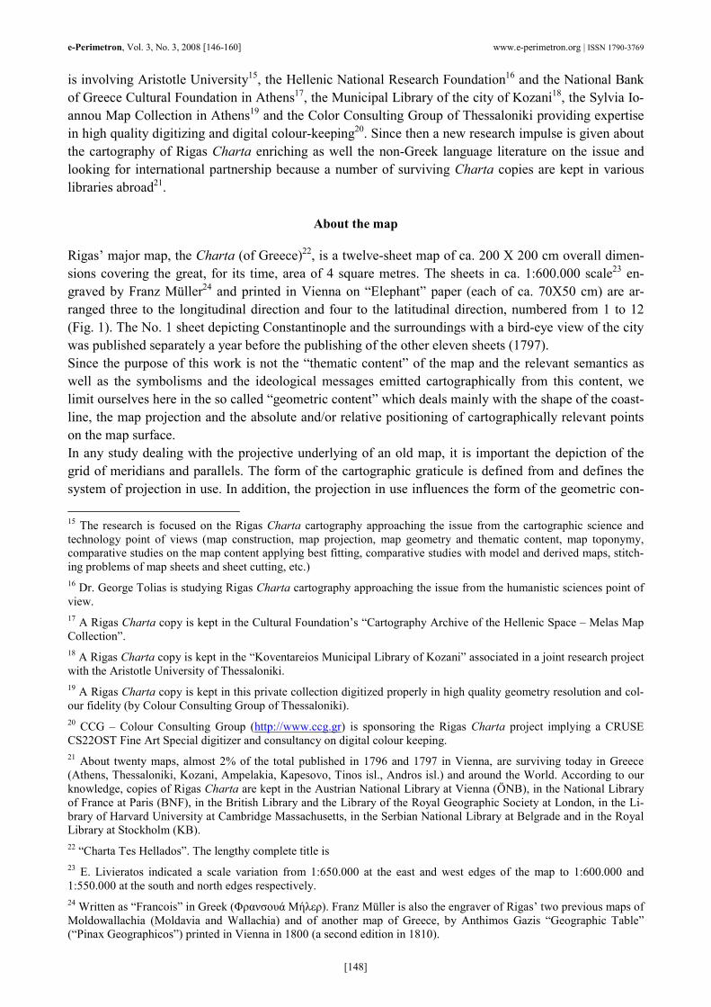
Using the known definition of Delisle’s map projection26 it can be easily designed, given a relevant de-tailed digital file of the coastline, the actual shape of Europe introducing the 30 and 60 degrees parallels as standard parallels and the 12 degrees meridian as the central meridian of the projection. The result is shown in Fig. 5 with the Ferro zero meridian in red and the standard parallels and the central meridian in pink.
Fig. 5. The actual coastline of Europe mapped in the Delisle’s conic projection. In pink the two standard 30 and 60 degrees parallels
and the 12 degrees meridian. In red the Ferro zero meridian. Fitting the Delisle 1707 map (Fig. 4) into the relevant actual grid and coastline in Delisle map projection (Fig. 5) by using proper mathematical tools27 we obtain a perfect agreement both in the map-grid and the coastline of the two maps as it can be seen in Fig. 6.
26 See, e.g., E. Grafarend and F. Krumm, 2006: Map projections, Springer. 27 C. Boutoura and E. Livieratos, 2006: Some fundamentals for the study of the geometry of early maps by comparative methods, e-Perimetron, Vol. 1, No. 1, 60-70.
e-Perimetron, Vol. 3, No. 3, 2008 [146-160] www.e-perimetron.org | ISSN 1790-3769
[152]
Fig. 6. The best fitting of Delisle early 18th century map of Europe to the actual grid and relevant coastline in Delisle’s map projec-
tion
Maps following the Delisle’s map standard
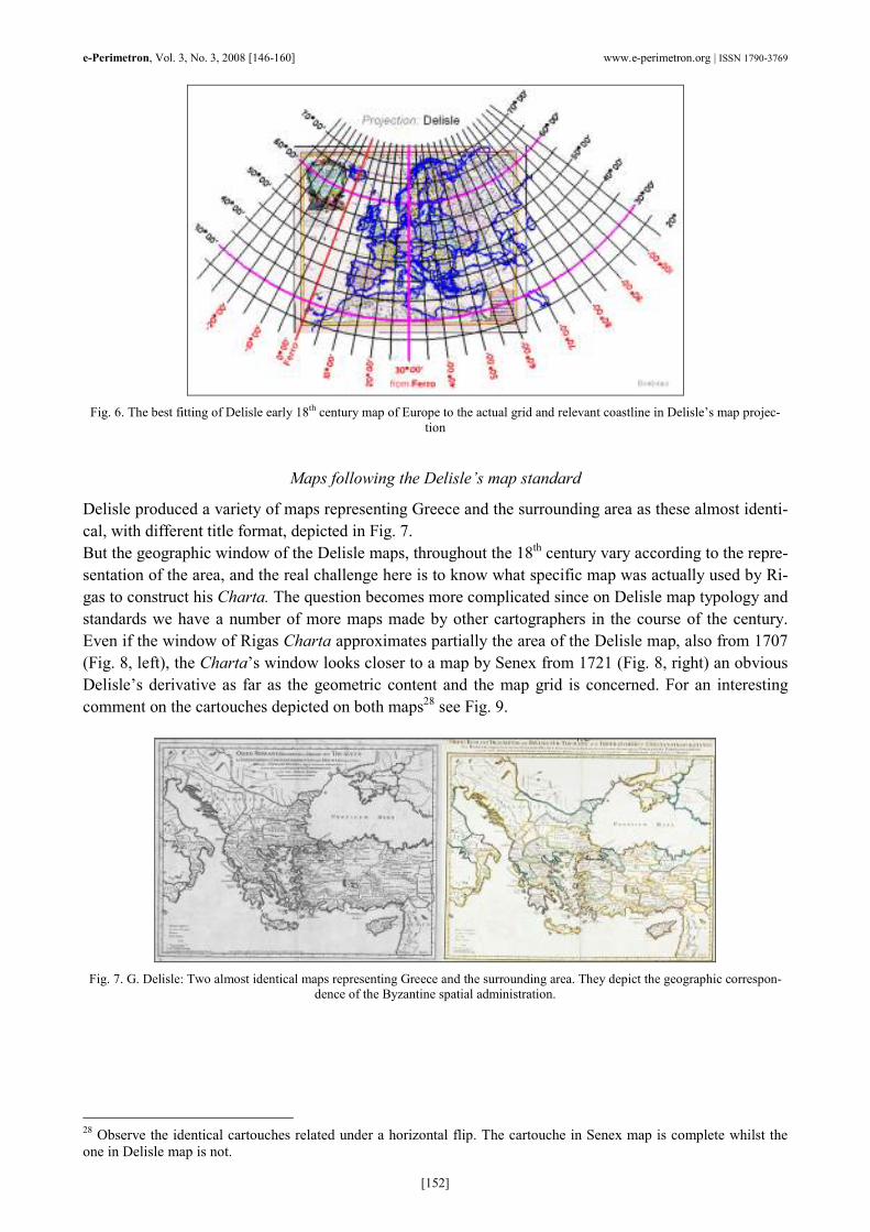
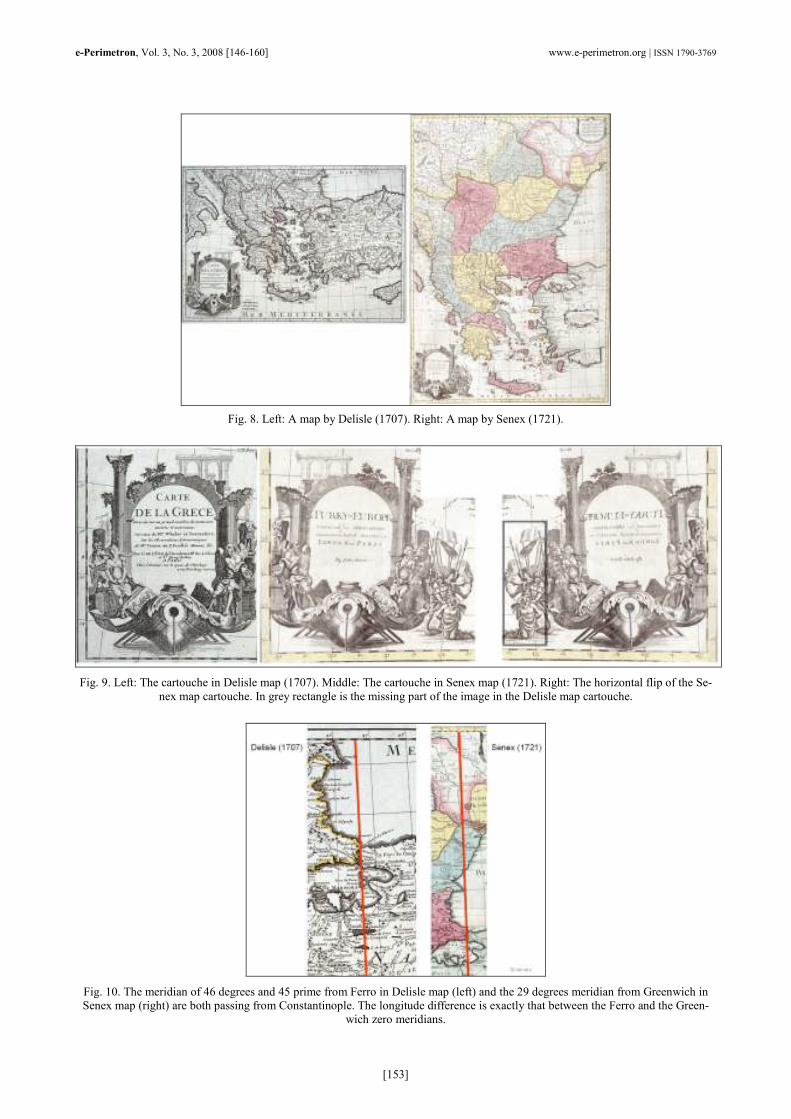
Delisle produced a variety of maps representing Greece and the surrounding area as these almost identi-cal, with different title format, depicted in Fig. 7. But the geographic window of the Delisle maps, throughout the 18th century vary according to the repre-sentation of the area, and the real challenge here is to know what specific map was actually used by Ri-gas to construct his Charta. The question becomes more complicated since on Delisle map typology and standards we have a number of more maps made by other cartographers in the course of the century. Even if the window of Rigas Charta approximates partially the area of the Delisle map, also from 1707 (Fig. 8, left), the Charta’s window looks closer to a map by Senex from 1721 (Fig. 8, right) an obvious Delisle’s derivative as far as the geometric content and the map grid is concerned. For an interesting comment on the cartouches depicted on both maps28 see Fig. 9.
Fig. 7. G. Delisle: Two almost identical maps representing Greece and the surrounding area. They depict the geographic correspon-
dence of the Byzantine spatial administration.
28 Observe the identical cartouches related under a horizontal flip. The cartouche in Senex map is complete whilst the one in Delisle map is not.
e-Perimetron, Vol. 3, No. 3, 2008 [146-160] www.e-perimetron.org | ISSN 1790-3769
[153]
Fig. 8. Left: A map by Delisle (1707). Right: A map by Senex (1721).
Fig. 9. Left: The cartouche in Delisle map (1707). Middle: The cartouche in Senex map (1721). Right: The horizontal flip of the Se-
nex map cartouche. In grey rectangle is the missing part of the image in the Delisle map cartouche.
Fig. 10. The meridian of 46 degrees and 45 prime from Ferro in Delisle map (left) and the 29 degrees meridian from Greenwich in Senex map (right) are both passing from Constantinople. The longitude difference is exactly that between the Ferro and the Green-
wich zero meridians.

e-Perimetron, Vol. 3, No. 3, 2008 [146-160] www.e-perimetron.org | ISSN 1790-3769
[154]
Fig. 11. The map by Blair (1768) where the geographic grid is entirely drawn represents a large area depicted in Rigas Charta. The
zero meridian is Ferro.
Fig. 12. Right: The digital fit of Blair’s map (1768) to a modern counterpart drawn in Delisle projection (in blue). Left: The digital fit
of Delisle’s map (1707) to a modern counterpart drawn in Delisle projection (in blue).
The digital best fitting analysis of the two maps also confirms that the overall content geometry of both is identical. As it is shown in the details of both maps shown in Fig. 10, even if the origin of the longi-tudes in both maps is different, 46 degrees and 45 primes from Ferro zero meridian in Delisle map, 29 degrees from Greenwich zero meridian in Senex map, the correspondence of the map content is identi-cal, namely Constantinople, the emblematic major city in the Charta projection analysis as we will see later, also depicted in a separate Charta map sheet (No. 1). The map by Blair from 1768 (Fig. 11), where the geographic grid is entirely drawn, represents a large area depicted in Rigas Charta. Fitting digitally this map to a modern counterpart drawn in Delisle pro-jection (Fig. 12, Right, the actual grid in blue) we observe a good agreement of the grid and of the geo-metric content without a significant deformation of the original. The same holds for the 1707 Delisle map (Fig. 12, Left, the actual grid in blue).

e-Perimetron, Vol. 3, No. 3, 2008 [146-160] www.e-perimetron.org | ISSN 1790-3769
[155]
Fig. 13. Right: The Lotter map from 1778 in two sheets (Graecia pars settentrionalis and Graecia pars meridionalis) with a com-plete drawn grid is a perfect copy of Delisle map also in two sheets from 1700 and its 1794 copy (left), with the grid values only
around the frame. Observe that in both cases the east side frame line is passing from Constantinople.
Fig. 14. The almost identical cartouches in the two sheets Delisle’s map (left) from 1700 and its 1794 copy and in the Lotter’s two
sheets map from 1778 (middle). Note the similarities in the cartouche of Rigas Charta (right).
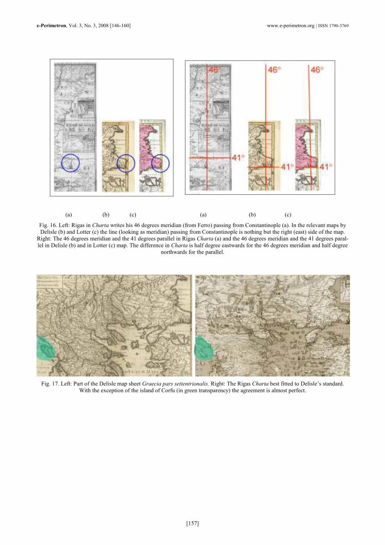
The Lotter map from 1778 in two sheets (Graecia pars settentrionalis and Graecia pars meridionalis) is a perfect copy of Delisle map also in two sheets from 1700 and its 1794 copy (Fig. 13). Even the car-touches in both maps are almost identical (Fig. 14, left and middle) with impressive similarities with the cartouche in Rigas Charta (Fig. 14, right). Here we should underline that the east side frame line of both maps is passing from Constantinople. This line is not of course the trace of a meridian but as we will see later, may played a crucial role in the relevant framing of Charta designed by Rigas.
The projection in Rigas Charta
Rigas Charta is a map of the same period apparently based on some of the previous maps. Its grid val-ues of longitude from Ferro zero meridian and of latitude are written on the frame of the map (Fig. 15, left). Rigas did not trace the meridians and the parallels on the map surface; we did it empirically for the shake of the study (Geographic grid). The coastline (Fig. 15, right) looks detailed and the map content is rich. Let us see now the relation of Charta’s grid, the coastline and the map content in relation to the previous maps. Focusing on the area associated to the city which presumably was the most important to Rigas, that is Constantinople, the reference point for the Greeks, we observe that the 46 degrees meridian in

e-Perimetron, Vol. 3, No. 3, 2008 [146-160] www.e-perimetron.org | ISSN 1790-3769
[156]
Charta passes from that city despite the fact that in all other maps passes almost half degree west-wards29. It is possible to make the hypothesis that this error was the result of a confusion related to the right line edge of the framing passing from Constantinople as it was designed on the maps used by Ri-gas for drawing Charta. The right edge line was taken as the image of the 46 degrees meridian. But also in the parallels depiction an almost half degree displacement is evident. A hypothesis can be also ex-pressed here that Rigas may intensively was wrong in choosing an integer longitude for Constantinople opting for the symbolism rather than for the map projection reliability.
Fig. 15. Rigas writes the longitudes (from Ferro zero meridian) and the latitudes on the frame of the map without tracing the geo-
graphic grid. Here it is done empirically (left) for the shake of the study. The coastline (right) is detailed.
Neglecting this important particularity which has to do with Charta’s grid of meridians and parallels, a best fitting process30 of its content to Delisle’s counterpart is applied. The fitting gives an excellent re-sult with the exception of Corfu which apparently was copied by Rigas, for his own reasons31, from other sources. The fitting shows a perfect agreement with Delisle map standard concerning the shape and the absolute and relative spatial positioning of Charta’s geometric map content (Fig. 17). The same holds fitting Charta to Blair’s map (Fig. 18). A closer look shows that though the map geo-metric content of the two maps is almost the same and a relevant grid in Delisle projection (in blue) co-incides to that of Blair’s map, the Rigas Charta grid follows the meridian pattern in the central part of Greece but deviates considerably at the edges. What really happened here? Most probably, the strong focusing of Rigas on the map content, the extended dimensions of Charta and the copying techniques in a much larger scale which probably were implemented32, lead to the erroneous drawing of the grid. Ob-viously Rigas designed an impressive map, as far as the geometric and especially the thematic content is concerned but most probably was not so familiar with map projections. The good point-wise approximation of the geometric map content of Rigas Charta to that of the Delisle-standard can be better shown using a two-window digital navigation tool33 for the visualization of an one-to-one correspondence between a pair of maps under comparison (Fig. 19). 29 This was first reported by E. Livieratos 30 Boutoura and Livieratos, 2006. 31 There is no reference on this in the current literature. 32 Recently Evangelos Livieratos made the hypothesis of a pantograph assisted copying by Rigas of a Delisle-standard map, or a combination of maps of Delisle-standard, enlarging the original scale in the pantograph copying process. See, E. Livieratos, 2007: “Cartographic” issues in Rigas Charta (in Greek), invited presentation at the Symposium Charta tou Riga Feraiou 1797-2007 (Rigas Feraios Charta 1797-2007), Bank of Cyprus Cultural Foundation, Nicosia, 27 Oc-tober 2007 [ also in: http://cartography.web.auth.gr/Livieratos/Rigas_Nicosia.pdf ]. 33 This digital visualization tool was developed in 2001 by Francesco Guerra and his group at CIRCE, University IUAV of Venice by applying morphing techniques.
e-Perimetron, Vol. 3, No. 3, 2008 [146-160] www.e-perimetron.org | ISSN 1790-3769
[157]
(a) (b) (c) (a) (b) (c) Fig. 16. Left: Rigas in Charta writes his 46 degrees meridian (from Ferro) passing from Constantinople (a). In the relevant maps by Delisle (b) and Lotter (c) the line (looking as meridian) passing from Constantinople is nothing but the right (east) side of the map. Right: The 46 degrees meridian and the 41 degrees parallel in Rigas Charta (a) and the 46 degrees meridian and the 41 degrees paral-lel in Delisle (b) and in Lotter (c) map. The difference in Charta is half degree eastwards for the 46 degrees meridian and half degree
northwards for the parallel.
Fig. 17. Left: Part of the Delisle map sheet Graecia pars settentrionalis. Right: The Rigas Charta best fitted to Delisle’s standard.
With the exception of the island of Corfu (in green transparency) the agreement is almost perfect.

e-Perimetron, Vol. 3, No. 3, 2008 [146-160] www.e-perimetron.org | ISSN 1790-3769
[158]
Fig. 18. The Charta best fitting on Blair’s map of Delisle-standard; the fitting of the Delisle projection grid of meridians and parallels
on Blair map and the deviation of the meridians referred to Charta towards the map edges.
Fig. 19. Two examples of the point-wise visualization of the approximation of the geometric content of Rigas Charta (left image) to
a Delisle-standard map (right image) using a two-window navigation digital visualization tool.
e-Perimetron, Vol. 3, No. 3, 2008 [146-160] www.e-perimetron.org | ISSN 1790-3769
[159]
Conclusions
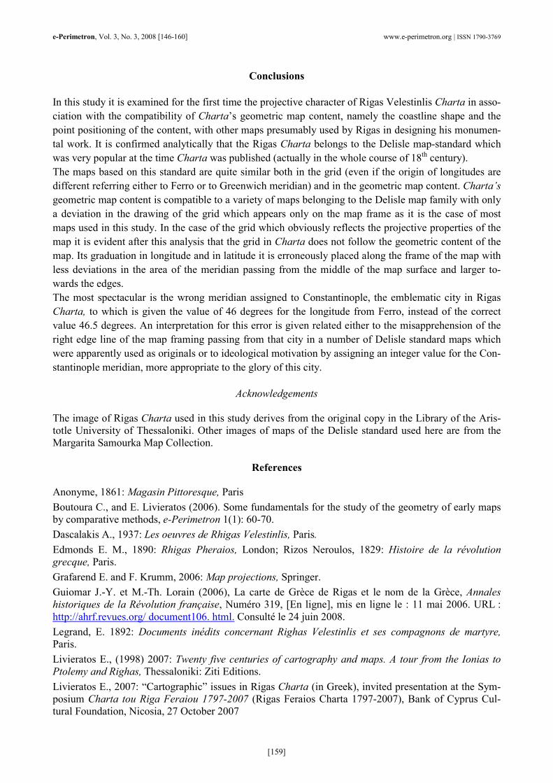
In this study it is examined for the first time the projective character of Rigas Velestinlis Charta in asso-ciation with the compatibility of Charta’s geometric map content, namely the coastline shape and the point positioning of the content, with other maps presumably used by Rigas in designing his monumen-tal work. It is confirmed analytically that the Rigas Charta belongs to the Delisle map-standard which was very popular at the time Charta was published (actually in the whole course of 18th century). The maps based on this standard are quite similar both in the grid (even if the origin of longitudes are different referring either to Ferro or to Greenwich meridian) and in the geometric map content. Charta’s geometric map content is compatible to a variety of maps belonging to the Delisle map family with only a deviation in the drawing of the grid which appears only on the map frame as it is the case of most maps used in this study. In the case of the grid which obviously reflects the projective properties of the map it is evident after this analysis that the grid in Charta does not follow the geometric content of the map. Its graduation in longitude and in latitude it is erroneously placed along the frame of the map with less deviations in the area of the meridian passing from the middle of the map surface and larger to-wards the edges. The most spectacular is the wrong meridian assigned to Constantinople, the emblematic city in Rigas Charta, to which is given the value of 46 degrees for the longitude from Ferro, instead of the correct value 46.5 degrees. An interpretation for this error is given related either to the misapprehension of the right edge line of the map framing passing from that city in a number of Delisle standard maps which were apparently used as originals or to ideological motivation by assigning an integer value for the Con-stantinople meridian, more appropriate to the glory of this city.
Acknowledgements
The image of Rigas Charta used in this study derives from the original copy in the Library of the Aris-totle University of Thessaloniki. Other images of maps of the Delisle standard used here are from the Margarita Samourka Map Collection.
References
Anonyme, 1861: Magasin Pittoresque, Paris
Boutoura C., and E. Livieratos (2006). Some fundamentals for the study of the geometry of early maps by comparative methods, e-Perimetron 1(1): 60-70.
Dascalakis A., 1937: Les oeuvres de Rhigas Velestinlis, Paris.
Edmonds E. M., 1890: Rhigas Pheraios, London; Rizos Neroulos, 1829: Histoire de la révolution grecque, Paris.
Grafarend E. and F. Krumm, 2006: Map projections, Springer.
Guiomar J.-Y. et M.-Th. Lorain (2006), La carte de Grèce de Rigas et le nom de la Grèce, Annales historiques de la Révolution française, Numéro 319, [En ligne], mis en ligne le : 11 mai 2006. URL : http://ahrf.revues.org/ document106. html. Consulté le 24 juin 2008.
Legrand, E. 1892: Documents inédits concernant Righas Velestinlis et ses compagnons de martyre, Paris.
Livieratos E., (1998) 2007: Twenty five centuries of cartography and maps. A tour from the Ionias to Ptolemy and Righas, Thessaloniki: Ziti Editions.
Livieratos E., 2007: “Cartographic” issues in Rigas Charta (in Greek), invited presentation at the Sym-posium Charta tou Riga Feraiou 1797-2007 (Rigas Feraios Charta 1797-2007), Bank of Cyprus Cul-tural Foundation, Nicosia, 27 October 2007
e-Perimetron, Vol. 3, No. 3, 2008 [146-160] www.e-perimetron.org | ISSN 1790-3769
[160]
Lopez Villalba M., 2003: «Traducir la revolucion: Nueva constitucion politica de Rigas de Velestino», Madrid: CSIC.
Nicolopoulo, C., 1824: Notice sur la vie de Rhigas, Paris.
Robinson A. H., J. L. Morrison, P. C. Muehrcke, A. Jon Kimerling, S. C. Guptill, 1995: Elements of Cartography, John Wiley.
Rubio Carracedo J., 1999: La «Nueva Constitución Política» de Rigas Velestinlis, Revista de Estudios Políticos (Nueva Época), Núm. 105, Julio-Septiembre, 295-308
Ubicini J.-H. A., 1881: La Grande Carte par Rhigas, Paris.
Woodhouse C. M., 1995: Rhigas Velestinlis: The Proto-martyr of the Greek Revolution, Denise Harvey.


![From Rigas Velestinlis to Ivo Andric - balcanica.rs 29/12 Miodrag... · UDe [886.1:877.4].091 Original Scholarly Work Miodrag STOJANOVIC Faculty of Philology Belgrade FROM RIGAS VELESTINLIS](https://static.fdocuments.net/doc/165x107/5e0744c55abc2330021f83d0/from-rigas-velestinlis-to-ivo-andric-2912-miodrag-ude-88618774091.jpg)


