On Teaching a Totally Blind Student Physical and ... · On Teaching a Totally Blind Student...
26
10/26/2011 1 On Teaching a Totally Blind Student Physical and Historical Geology by Kenneth R. Neuhauser Department of Geosciences Fort Hays State University Jason Hughes and ‘Indy’ Jason’s present goal = PhD with a focus on vertebrate paleontology.
Transcript of On Teaching a Totally Blind Student Physical and ... · On Teaching a Totally Blind Student...

10/26/2011
1
On Teaching a Totally Blind
Student Physical and Historical Geology
by
Kenneth R. Neuhauser
Department of Geosciences
Fort Hays State University
Jason Hughesand ‘Indy’
Jason’s present goal = PhD with a focus on vertebrate paleontology.

10/26/2011
2
Dr. Geerat Vermeij
Dr. Tim Cordes
Biggest Barrier = Too many said ‘No”

10/26/2011
3
The Process
• Lectures • Labs• Physical Field Trip• Future classes + challenges• Future classes + challenges
Extra Staff
Adam Staab Mike Calvello

10/26/2011
4
Lectures• No major barriers
• Braille NoteTaker + texts (audio)• Braille NoteTaker + texts (audio)
• E‐mail + Cell phone communication
• Must be more descriptive with presentations.
• Exams administered through FHSU’s Kelly• Exams administered through FHSU s Kelly Center ‐ Disability Student Services.

10/26/2011
5

10/26/2011
6

10/26/2011
7

10/26/2011
8
Physical Lab

10/26/2011
9
10/26/2011
10
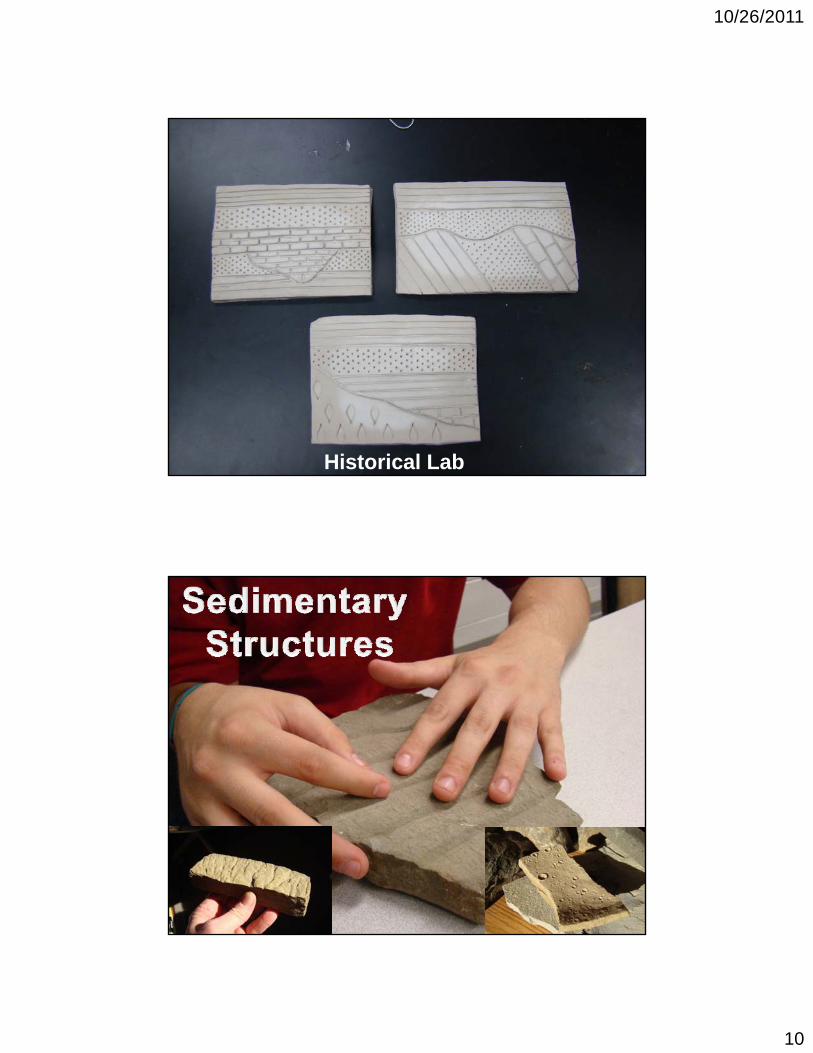
Historical Lab

10/26/2011
11

10/26/2011
12

10/26/2011
13

10/26/2011
14

10/26/2011
15
Measuring a Stratigraphic
SectionSection

10/26/2011
16
Future Challenges• Paleontology• Mineralogy
• Petrology• Structural Geology = sabbaticalStructural Geology sabbatical
• Field Methods
• Summer Geology Field Camp

10/26/2011
17
10/26/2011
18

10/26/2011
19

10/26/2011
20
Know this
diagram!!
Strain hardening
diagram!!

10/26/2011
21

10/26/2011
22
Direct application of labels causescauses wrinkles.
Using Braille font in Word
has eliminated that issue.

10/26/2011
23

10/26/2011
24
FielGeologic Field Methods

10/26/2011
25
Abstract:•A suspected old artillery range from Old Fort Hays is possibly present at the locality surveyed west of Fort Hays State University just off of Old Highway 40 alongside the Hays M i i l G lf C A id t
Methodology:Field Methodology
•At the old artillery range we set up a grid that was 30m wide by 50m long, with flags set every 10m within the grid. We then used the magnetometer through the grid to find magnetic1 Municipal Golf Course. A grid was set
up to take magnetometer readings to find possible sites for the excavation of old cannonballs. Using geophysical software we attempted to interpret locations of magnetic anomalies resulting from buried ferrous material. Small anomalies were found throughout our grid area that could be possible sites excavation to look for cannonballs.
Introduction:•Old Fort Hays existed from 1865-1889. During this period the 7th Calvalry, 5th
Infantry, and 10th Calvalry, were at times stationed there. An artillery range used during Old Fort Hays’ existence is suspected to be located at the magnetometer test site.
through the grid to find magnetic anomalies under the subsurface.
Lab Methodology• In the lab we used the magnetometer data from the field to create a visual analysis of the readings. We utilized various computer programs including MagMap 2000, ArcView, and Surfer.
Observations:•The northwestern border (top on the map) boundary of the survey plot was bounded by a barbed-wire fence set in the ground with metal posts. This is probably the cause of the magnetic anomaly in this section of the plot.•Our east-west baseline sat roughly 30 degrees north of east. This probably explains the lack of a distinctive positive-negative reading at any particular location.
Figure 5: Map view of the test grid showing the magnetic anomalies. The line shows the anomaly
Figure 1: Inset map showing the location of the test site relative to the city of Hays.
Figure 2: Team members measuring and setting up the grid at the test location
Figure 3: Team member taking magnetometer readings along grid lines.
N
N
1 mile
Location: •We set up our grid just off old 40 highway next to the Hays municipal golf course. The easting and northing readings at the sight are 0469770 and 4302064 respectively.
Conclusions:•Although anomalies were found throughout our grid area, we were unable to test our results by excavation. We would like to thank the City of Hays for allowing us to use their land for this survey, as well as Dr. Neuhauser and the Geosciences Department at Fort Hays for allowing us to use the magnetometer and software.
References:•http://www.planetware.com/pi cture/springfield-wilsons-creek-national-battlefield-us-mo232.htm •http://en.wikipedia.org/wiki/Fort_Hays
g ychosen of which a profile was created.
Figure 6: Profile along the line in figure 1. The rectangle shows the possible depth to buried material.
up the grid at the test location.
Figure 3: Team members aligning grid orientation.
Geology Field Camp
Rugged Terrain

10/26/2011
26
• Learning Outcomes
• Change major to Biology?• Change major to Biology?
• Graduate School?
• Apprenticeships?
• Museum Studies degree?
"The positive thinker sees the invisible, feels the intangible, and achieves the impossible."
Author Unknown
Acknowledgements• Jason Hughes + Indy
• The Kelly Center ‐ FHSU
• Mike Calvello and Adam Staab
• Dr. Geerat Vermeij
• Dr. Tim Cordes
• The geology class in Physical and Historical Geology