Old North End Greenway - burlingtonvt.gov
20
Old North End Greenway Technical Feasibility Study Prepared for: The City of Burlington Department of Public Works Prepared by: April, 2017
Transcript of Old North End Greenway - burlingtonvt.gov

Old North End Greenway Technical Feasibility Study
Prepared for: The City of Burlington Department of Public Works
Prepared by:
April, 2017

planBTV Walk Bike |Old North End Greenway Feasibility Study
Table of Contents
Page i
1 Introduction .............................................................................. 1 1.1 planBTV Walk Bike .............................................................. 1 1.2 Old North End (ONE) Greenway ......................................... 2 1.3 planBTV Greenway Network .............................................. 3
2 Design of Neighborhood Greenways ......................................... 3 2.1 Traffic Calming .................................................................... 3 2.2 Signage and Pavement Marking ......................................... 4 2.3 Green Streets ..................................................................... 4 2.4 Intersection treatments ..................................................... 4 2.5 Prioritize Bicycle Travel ....................................................... 4
3 ONE Greenway Route ................................................................ 5 3.1 Existing Conditions on ONE Greenway Route ..................... 5
4 Recommended Greenway Design Plan...................................... 6 4.1 Bikeway Street Plans and Cross Sections ............................ 9
4.1.1 Sherman Street (North to Battery) ............................. 9 4.1.2 Sherman Street (Battery to Champlain) ................... 10 4.1.3 North Champlain (Sherman to Peru) ........................ 11 4.1.4 Elmwood Avenue (Peru to Grant)............................. 12 4.1.5 Grant Street .............................................................. 12 4.1.6 North Union St (Grant to Loomis) ............................. 13 4.1.7 Loomis Street ........................................................... 13
4.2 Signage and Pavement Markings ...................................... 14 4.2.1 Greenway Identity and Wayfinding Signage ............. 14 4.2.2 Greenway Pavement Markings ................................. 14
4.3 Traffic Calming and Green Infrastructure ......................... 16 5 Next Steps ............................................................................... 17
List of Figures Figure 1.1: Examples of Greenway Treatments .................................. 2 Figure 3.1: Walk and Bike Crashes (Source: VTrans, 2011-2016) ....... 5 Figure 4.1: Overview of Old North End Greenway: West ................... 7 Figure 4.2: Overview of Old North End Greenway: East ..................... 8 Figure 4.3: Greenway connection to Battery Park .............................. 9 Figure 4.4: Existing and Proposed Cross Sections-Sherman St-W .... 10 Figure 4.5: Existing and Proposed Sections for Sherman St-E .......... 10 Figure 4.6: Existing and Proposed Sections for North Champlain St 11 Figure 4.7: Existing and Proposed Sections: Elmwood ..................... 12 Figure 4.8: Existing and Proposed Cross Sections ............................. 13 Figure 4.9: Greenway Identify Signage ............................................ 14 Figure 4.10: Example of Identity and Directional Signage ................ 14 Figure 4.11: planBTV Walk Bike Greenway markings on Grant ........ 15 Figure 4.12: Bike Route Intersection Marking Options ..................... 15 Figure 4.13: Planted Buffer pilot installation .................................... 16 Figure 4.14: Speed Monitoring Results from North Union ............... 17 Figure 5.1: Pavement and Signage Greenway Plan .......................... 18 List of Tables Table 3.1: Traffic Volumes and Operations for ONE Greenway Route 5 Table 3.2: Street ROW and Pavement Widths .................................... 5 Table 5.1: Greenway Quantities ....................................................... 17

Page 1
1 Introduction
planBTV Walk Bike, Burlington’s first comprehensive master plan for bicycle and pedestrian infrastructure, has established a goal of increasing the mode share of bicycle travel from about 6% (commute mode share from the most recent American Community Survey) to 12%. To accomplish this goal, a city-wide bikeway network is proposed that appeals to riders of a wide range of abilities and levels of confidence. The plan maps out a rich bikeway network that will provide city residents with convenient access to “low-stress” bicycle facilities. Bicycle stress levels are influenced by traffic speed, traffic volume, and the type of facility. For example, on a major arterial route such as Main Street, low stress bicycle infrastructure requires separation from vehicular traffic. Alternatively, on a quiet residential street with limited traffic and low speeds, bicyclists of a wide range of abilities can ride on the street, shared with vehicle traffic, without feeling stressed by the conditions.
1.1 planBTV Walk Bike
The network map to the right shows the long-term bicycle network for the City. Low stress facilities include both the protected bicycle lanes on major corridors (shown in blue), shared use paths (solid green) and neighborhood greenways (dashed green lines). The concept of Neighborhood Greenways builds off successful experience in several US cities which have seen significant growth and expansion of bicycle transportation. By design, greenway corridors are transformed into appealing routes for walking and bicycling, using a variety of tools including wayfinding,
planBTV Walk Bike |Old North End Greenway Feasibility Study April 16, 2017
Page 2
signage, and traffic calming to reduce vehicular speeds. Intersection and safe crossing enhancements are used where needed. Landscaping and green stormwater infrastructure can also be incorporated to beautify the street and improve drainage and water quality. With Burlington’s dense street network, narrow right-of-ways, and high demand for on-street parking, creating conventional or protected bike lanes is challenging, making the desired network of low-stress bikeways difficult to achieve. Neighborhood Greenways can adapt the existing street network to contribute to the City’s future bicycle network, and bring many other benefits to the corridor.
1.2 Old North End (ONE) Greenway
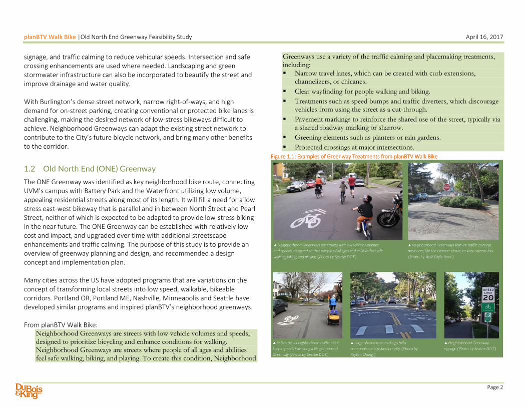
The ONE Greenway was identified as key neighborhood bike route, connecting UVM’s campus with Battery Park and the Waterfront utilizing low volume, appealing residential streets along most of its length. It will fill a need for a low stress east-west bikeway that is parallel and in between North Street and Pearl Street, neither of which is expected to be adapted to provide low-stress biking in the near future. The ONE Greenway can be established with relatively low cost and impact, and upgraded over time with additional streetscape enhancements and traffic calming. The purpose of this study is to provide an overview of greenway planning and design, and recommended a design concept and implementation plan. Many cities across the US have adopted programs that are variations on the concept of transforming local streets into low speed, walkable, bikeable corridors. Portland OR, Portland ME, Nashville, Minneapolis and Seattle have developed similar programs and inspired planBTV’s neighborhood greenways. From planBTV Walk Bike:
Neighborhood Greenways are streets with low vehicle volumes and speeds, designed to prioritize bicycling and enhance conditions for walking. Neighborhood Greenways are streets where people of all ages and abilities feel safe walking, biking, and playing. To create this condition, Neighborhood
Greenways use a variety of the traffic calming and placemaking treatments, including:
Narrow travel lanes, which can be created with curb extensions, channelizers, or chicanes.
Clear wayfinding for people walking and biking.
Treatments such as speed bumps and traffic diverters, which discourage vehicles from using the street as a cut-through.
Pavement markings to reinforce the shared use of the street, typically via a shared roadway marking or sharrow.
Greening elements such as planters or rain gardens.
Protected crossings at major intersections.
Figure 1.1: Examples of Greenway Treatments from planBTV Walk Bike

planBTV Walk Bike |Old North End Greenway Feasibility Study April 16, 2017
Page 3
1.3 planBTV Greenway Network
Neighborhood Greenways have been designated on City streets that have low traffic volumes and speeds (see map on page 1). Factors that may be associated with these characteristics include narrow widths, on-street parking, offset intersections (requires frequent changes of direction, leading to reduced vehicular volumes and speeds), and stop controlled intersections.
2 Design of Neighborhood Greenways
Neighborhood greenways can provide a quality experience for a wide range of people to walk and bike at any age and any ability level at relatively low cost, as they take advantage of available infrastructure (local street networks), and strategically adapt them into appealing routes with signage, pavement greening, and intersection modifications. A five-pronged approach can be use used to transform streets into neighborhood greenways:
1) Traffic Calming - to reduce the speeds of motor vehicles, making the
street safer for shared use of bicycles and cars.
2) Signage and Pavement Marking – to provide wayfinding for people
biking, and to alert motorists to expect bicycles.
3) Green Streets - incorporating plantings, street trees, and green
stormwater infrastructure into the street to make it more appealing to
people traveling on foot and bike, and to treat stormwater.
4) Intersection Design Treatments – to make crossing major streets
safer and more intuitive for people walking and biking.
5) Prioritize Bicycle Travel - in appropriate locations, traffic control
measures can be incorporated that favor the movement of bicycles.
The following sections provide options and design considerations for the above greenway design elements.
2.1 Traffic Calming
The City of Burlington has had an active traffic calming program for many years, which has involved neighborhood-initiated projects. Burlington’s traffic calming implementations will continue and potentially expand to support safer streets for walking in biking throughout the city, in particular on streets where there is a lack of pedestrian facilities, and on streets that have been identified as neighborhood greenways. The program may be City-initiated and must include consultation with emergency services to assure that traffic calming does not create a barrier to efficient emergency response. In addition, it is important to consider the winter maintenance implications of various traffic calming approaches to ensure year round function. There are many resources available that provide technical guidance for traffic calming. planBTV Walk Bike provides a description of traffic calming in its illustrated glossary, and summarized to the right. The traffic calming tools listed below can be incorporated into greenway projects.

planBTV Walk Bike |Old North End Greenway Feasibility Study April 16, 2017
Page 4
Speed humps
Speed lumps
Median islands
Curb extensions (potentially with stormwater infrastructure)
Raised crosswalks
Neighborhood traffic circles
Mini-roundabouts
Chicanes
Diverters
2.2 Signage and Pavement Marking
The greenway routes should be well-marked for the benefit of people walking, biking and in cars. Some greenway routes are “wiggles” that will require turning movements to stay on the route, so clear wayfinding signage is essential. This signage will also reinforce the presence and relative priority of bicycles to motor vehicles, and result in a safer shared street environment. The City should develop a greenway identity sign package to be used for greenway signage and wayfinding, which is described in more detail later in this report. Vermont state law requires that all traffic signs and markings comply with the MUTCD, or are conducted with permission for experimental treatments. While the minimum legal posted speed is 25 mph, advisory speed signage can encourage lower speeds.
2.3 Green Streets
While many traffic calming features can have the net effect of bringing in landscaping along street corridors, additional benefits can result from introducing street trees and green stormwater infrastructure where feasible, including shaded streets, buffering rainfall, increased the feeling of enclosure and security, lower traffic speeds and simply making the street more attractive. Poor drainage can create a challenge for all users, and green stormwater infrastructure can address these issues in an attractive and
environmentally beneficial manner. Suitable green streets opportunities for the Old North End Greenway include street tree planting and stormwater curb extensions, generally near intersections that receive runoff, and where soils and utility locations allow.
2.4 Intersection treatments
There are a variety of intersection modifications that can be used to make a greenway safer for walking and biking, especially where greenways intersect with higher volume corridors.
Curb extensions can provide protected and more visible places for people seeking to cross at an uncontrolled intersection.
Raised intersections can create a feeling of shared space between all modes of transportation, and inspire more attention and caution on the part of drivers.
Bikeway markings across the intersections, with use of green paint in appropriate locations, will provide guidance to riders on the best route across the intersection, and alert drivers to the likely presence of crossing bicycles.
Crossings for people walking or biking that are enhanced for safety and visibility, using rectangular rapidly flashing beacons or other measures.
Diverters or other strategic street closures to reduce potential conflicts between vehicles and people walking or biking along the Greenway.
2.5 Prioritize Bicycle Travel
In selected locations, it may be appropriate to alter the traffic control and priority at intersections to make it easier for bicycles to cross, e.g. not requiring bicycles to stop at all-way stop intersections if no conflicting traffic is present, or removing stop signs from the greenway route. The City of Burlington could also consider regulatory changes such as allowing the “Idaho Stop,” which allows people on bicycles to slow down and coast through a clear

planBTV Walk Bike |Old North End Greenway Feasibility Study April 16, 2017
Page 5
intersection rather than come to a complete stop, bicycling can become more convenient and enjoyable. Medians or diverters can also be used to change priority for bicycle travel.
3 ONE Greenway Route
The route for the ONE greenway was developed as part of planBTV Walk Bike. The considerations in developing the future bikeway network were to provide access to low-stress bikeways for the majority of City residents, and to provide a range of facility types that are suitable for the wide range of abilities and confidence levels among residents and visitors.
3.1 Existing Conditions on ONE Greenway Route
The designated route for the ONE Greenway has many features that are desirable for neighborhood greenways, but several locations along the route have higher volumes or one-way operations. The table below shows the traffic volumes (where available) and operation. Although traffic data is not available, it is expected that Sherman (east of Battery) and Peru have low traffic volumes (e.g. less than 2,000 vehicles per day), due to their character and role in the street network. The table to the right also shows that most of the Greenway length will be along lower volume streets, and only relatively short sections will be routed on the higher volumes streets (N. Champlain, Elmwood and N. Union). It is noteworthy that the volume of Grant Street between Elmwood and N. Winooski is nearly double the volume on the adjacent block, due to the one-way operation of Elmwood to the south. As part of planBTV Walk Bike, the crashes involving people biking and walking were mapped city-wide. The map to the right is an excerpt showing that the ONE Greenway Route has relatively few crashes compared to North St. and Pearl St. This is likely due primarily to lower volumes for all modes, as well as lower vehicle speeds. All of the crashes on the route occurred at intersections, highlighting the importance of safe intersection design.
Table 3.1: Traffic Volumes and Operations for ONE Greenway Route
Street Volume (ADT) Operation Length on Greenway
Sherman/North 11,400 Two-way 324
Sherman not available One-way westbound 425
N. Champlain 3,300 One-way northbound 137
Peru not available Two-way 1,013
Elmwood 3,700 Two-way 147
Grant (west of N. Winooski)
2,100 Two-way 618
Grant (east of N. Winooski)
1,100 Two-way 490
N. Union 3,900 One-way northbound 287
Loomis 1,500 Two-way 2,672
Figure 3.1: Walk and Bike Crashes (Source: VTrans, 2011-2016)
The right-of-way widths and pavements widths of each street is shown on the table on the following page. The narrowest street is Sherman (east of Battery), which serves only one-way traffic. The higher volume streets (N. Champlain, N. Union and Elmwood) have more pavement width available so that bicycle lanes can be provided. Most of the greenway route will be on narrower, but lower volume streets. Table 3.2: Street ROW and Pavement Widths within the Greenway
Street ROW Width (ft)
Pavement Width (ft)
Parking Grade (%)

planBTV Walk Bike |Old North End Greenway Feasibility Study April 16, 2017
Page 6
Sherman/North 66 35 None 1.3
Sherman 25.6 16.5 None 1.3
N. Champlain 66 35 East side <0.5
Peru 48 26 South side 1.6
Elmwood 66 35 None <0.5
Grant 49.5 26 North side <0.5
N. Union 49.5 26 West side <0.5
Loomis 60 30 South side 2.7
Compared to other east-west bike routes, the ONE greenway route has favorable grades for bicycling throughout its length. The steepest block is on Loomis St between Willard and Prospect, which is has a 3.9% grade. Grades of less than 4% are considered accessible to a wide range of people’s bicycle abilities.
4 Recommended Greenway Design Plan
The proposed greenway can be implemented through a combination of:
Changes in street cross sections on selected streets
Pavement marking and signage to function both for wayfinding and
branding the street for walk and bike priority
Emphasize walk and bike crossings at each intersection
Traffic calming to reduce vehicular speeds
Green stormwater infrastructure to improve drainage and enhance
the streetscape where feasible
Many Greenway features can be installed in phases, with quick-build materials used on an interim basis until full construction can be programmed. This approach also allows the City and the neighborhood to evaluate the features and make adjustments prior to construction. It is anticipated that the greenway will be maintained for bicycle travel year round, with snow removal on the portions with protected bicycle lanes using appropriate equipment. Among the goals of this project is to evaluate a variety of design treatments for protected bicycle lanes in terms of year around maintenance. The overview of the greenway design plan is shown on the figures on the following two pages, and described in more detail.

planBTV Walk Bike |Old North End Greenway Feasibility Study April 16, 2017
Page 7
Figure 4.1: Overview of Old North End Greenway: Western Section

planBTV Walk Bike |Old North End Greenway Feasibility Study April 16, 2017
Page 8
Figure 4.2: Overview of Old North End Greenway: Eastern Section

planBTV Walk Bike |Old North End Greenway Feasibility Study April 16, 2017
Page 9
4.1 Bikeway Street Plans and Cross Sections
4.1.1 Sherman Street (North to Battery)
The greenway route begins at Battery Park, connecting to the shared use path that leads to the Battery St promenade. Connection to the waterfront will be made via Depot St. This connection will be among the most complex segments
of the greenway, and require a new high visibility crosswalk, changes to the cross section of Sherman Street between Battery St and North Ave, and new pavement and curbing to provide for turning paths of larger vehicles traveling north from Battery to North Ave.
Figure 4.3: Greenway connection to Battery Park and the Waterfront

planBTV Walk Bike |Old North End Greenway Feasibility Study April 16, 2017
Page 10
The existing and proposed changes in the cross section of Sherman Street (between North Avenue and Battery Street) are shown below. With the higher traffic volume on this block of Sherman Street, a separated bicycle facility is needed to provide for low-stress bicycle travel. The alignment of the greenway allows for a two-way protected bikeway on the north side of Sherman, which will have two low volume driveway crossings. This allows the greenway to avoid conflicts with the high volume traffic turning from Battery onto Sherman. Figure 4.4: Existing and Proposed Cross Sections-Sherman St between North Ave and Battery
4.1.2 Sherman Street (Battery to Champlain)
As the greenway crosses Battery Street, it will use the low volume, one-way segment of Sherman Street between Battery and N. Champlain. Currently, there is one travel lane that is 16.5 feet wide. This can be restriped to provide a five foot eastbound contraflow bike lane and shared lane for westbound bicycle travel.
Figure 4.5: Existing and Proposed Sections for Sherman St (Battery to Champlain)

planBTV Walk Bike |Old North End Greenway Feasibility Study April 16, 2017
Page 11
4.1.3 North Champlain (Sherman to Peru)
In order for the greenway to provide 2-directional bicycle travel on North Champlain Street, reconfiguration of the travel lanes will be required, as shown below. This is consistent with the future bicycle network in planBTV Walk Bike, which provides a 2-way separated bicycle lane on this street. Traffic volumes on North Champlain are well within the range that can be served with a single northbound travel lane, allowing the second northbound lane to be re-purposed for low stress bicycle travel. This will have no effect on parking. The effect on vehicular travel will primarily be reduced speeds, as passing will no longer be possible, but there is ample vehicular capacity with a single northbound lane. In the short term, the bikeway can be separated by a painted buffer strip reinforced by delineator posts. In the longer term, a more attractive landscaped buffer could be installed that would reduce the pavement area and potentially provide for stormwater management.
Figure 4.6: Existing and Proposed Short Term Sections for North Champlain St (Sherman to Peru)
The short term plan for crossing North Champlain is shown in the diagram below, which maintains the northbound bike lane on the left side of the street, and reassigns the parking lane to a 2-way separated bike lane on the east side of the street between Sherman and Peru. This requires the travel lanes to be narrowed from 11 feet to 10 feet each, so that a 2 foot buffer can be provided. Figure 7: Old North End Greenway Crossing of North Champlain Street

planBTV Walk Bike |Old North End Greenway Feasibility Study April 16, 2017
Page 12
In the longer term, planBTV Walk Bike proposes lane reassignment for North Champlain Street between Pearl and Manhattan as shown below. An analysis of traffic volumes at key intersections shows that this can be accomplished without creating traffic congestion. The lane reassignment should reduce traffic speeds and increase safety for all users in this corridor. Figure 8: Long Term Cross Section for North Champlain Bikeway
4.1.4 Elmwood Avenue (Peru to Grant)
The short section of Elmwood Avenue between Peru and Grant has higher traffic volumes and is a bus route, and protected bicycle lanes can be provided within the paved area for a low stress greenway connection. There is no on-street parking permitted in this section of Elmwood, due to the proximity of intersections and crossings, so the bicycle lanes have no effect on neighborhood parking. The cross section shown to the right includes 5 feet bicycle lanes separated from the travel lanes by a 1.5 foot raised buffer. Other design options are possible as budgets and preferences dictate. While not required for the greenway to be established, it is recommended that the City consider converting Elmwood Avenue to two-way operation south of Grant Street. It is currently designated as one-way northbound in order to provide diagonal parking access to the Post Office at Elmwood and Pearl Streets. However, this requires southbound traffic on Elmwood to divert onto neighborhood streets, including GMTA buses. Currently significant traffic diverts onto Grant Street and to continue south on North Winooski. With the
reopening of Elmwood to 2-way traffic, volumes on Grant Street would be reduced, and there would be greater opportunities to implement traffic calming as bus traffic would not need to be accommodated. Figure 4.9: Existing and Proposed Sections: Elmwood from Peru to Grant
4.1.5 Grant Street
This low volume street will have pavement markings and wayfinding signage to highlight the bicycle route. The narrow width and high utilization of neighborhood parking, combined with low traffic volumes and traffic calming features, make it appropriate for shared use of vehicles and bicycles.

planBTV Walk Bike |Old North End Greenway Feasibility Study April 16, 2017
Page 13
4.1.6 North Union St (Grant to Loomis)
The greenway route travels along a short section of North Union, which currently operates with one-way northbound vehicular traffic, parking on the west side of the street, and a buffered bicycle lane on the east side of the street (See Figure 4.10, to the right, top). As volumes are relatively higher on this street, some type of separation from traffic is needed to provide a low-stress bicycle connection. This can be done within the existing paved area by re-purposing the parking lane to provide a protected contraflow bicycle lane. On-street parking is permitted on the west side of North Union St, although the parking spaces are not marked. Observations indicate that there are typically up to 8 parked vehicles that would be displaced with the lane reassignment. The cross sections to the right, below, show the bike lane separated by flexible bollards in the southbound direction, and a concrete curb in the northbound direction. Other options can be considered, such as Tuff-Curb or armadillos, pending the outcome of pilot projects in Burlington that have been or will be evaluating these options.
Figure 4.10: Existing and Proposed Cross Sections: North Union from Grant to Loomis
4.1.7 Loomis Street
The low volume and existing traffic calming features on Loomis Street make it appropriate for shared use between vehicles and bicycles. Pavement markings and wayfinding will be provided, plus high visibility crossings at intersections with major thoroughfares (North Willard and North Prospect Streets).

planBTV Walk Bike |Old North End Greenway Feasibility Study April 16, 2017
Page 14
4.2 Signage and Pavement Markings
Bicycle travel along the greenway will be facilitated by several types of signage and information. Signs that direct people walking and biking (and alert people in cars) to the greenway route will provide directional information to follow the route, and can be supplemented by destinations and distances. Pavement markings will also be important components of the greenway, showing bike riders the direction of travel, and alerting motorists on where to expect bicycles. The following sections discuss signage and pavement markings.
4.2.1 Greenway Identity and Wayfinding Signage
The images below shows several examples of Greenway identity signage. A sign installation of greenway directional signage from Seattle’s greenway network is shown to the right. Figure 4.11: Greenway Identify Signage from Nashville, Portland and Seattle
The City of Burlington is currently developing a signage and branding system for the neighborhood greenways, which is intended to be used for the implementation of the ONE Greenway. Section 2D.50 of the MUTCD provides guidance on community wayfinding signs, including signs for non-motorized users. The guidelines provide ample flexibility for Greenway signing and should be considered in the placement of Greenway signs.
Figure 4.12: Example of Identity and Directional Signage, Seattle Greenways
4.2.2 Greenway Pavement Markings
Pavement markings along the streets and particularly across intersections is an important feature to assure riders on where they should travel, and will also signal to motorists that they should expect to encounter bicycles along their route. Green-backed super-sharrows are recommended for all neighborhood greenways as a highly effective marking to highlight the greenway route to all users. This was piloted at the Grant Street demonstration project as part of planBTV Walk Bike, shown in the following figure, a large white sharrow is superimposed on a green rectangle, and lined with dashed white lines on either side. This pavement marking is currently approved as an experimental treatment through the FHWA’s experimental program. The City can apply to

planBTV Walk Bike |Old North End Greenway Feasibility Study April 16, 2017
Page 15
the FHWA to be a participant in an ongoing experiment to review this treatment, and must identify performance measures and a data collection plan to determine success in the measures, such as crash rate reduction, riding location (i.e. keeping people riding bicycles outside of the door zone), or .vehicular speed reduction
https://www.fhwa.dot.gov/environment/bicycle_pedestrian/guidance/mutcd/index.cfm
Figure 4.13: planBTV Walk Bike Demonstration of Greenway markings on Grant Street
At intersections, pavement markings should highlight where a bike lane crosses a street. There are a number of effective options, some of which include the use of green paint, and most include a combination of sharrows and dashed lines. There is continuous research on the most effective and durable type of symbol, and the exact design used should consider the most current research at the time of implementation. The important feature is that the markings guide cyclists across the intersection with a highly visible path. The following figure from the NACTO Urban Bikeway Design guide provides an array of markings that can be effective. Figure 4.14: Bike Route Intersection Marking Options
Credit: NACTO Urban Bikeway Design Guide

planBTV Walk Bike |Old North End Greenway Feasibility Study April 16, 2017
Page 16
4.3 Traffic Calming and Green Infrastructure
Reducing traffic speeds is among the most important and effective ways to create safe streets that are shared among different modes of transportation. Already, several traffic calming projects are underway along the Greenway Route: on Grant Street between North Union and North Winooski; and on Loomis Street between North Willard and North Prospect. These projects both went through the neighborhood traffic calming planning process, which includes consultation of neighborhood residents, emergency service providers, and Department of Public Works staff. Ultimately, neighborhood residents are asked to approve the project through a mail-in ballot. The type of traffic calming measures that have been most widely used by recent City traffic calming projects include curb extensions (which include potential for bio-retention gardens for stormwater), speed humps or lumps, neighborhood traffic circles and median islands. While the introduction of some of these elements should reinforce lower speeds on Grant and Loomis Streets, over time, additional traffic calming can reinforce lower vehicle speeds along the remaining length of the greenway. At this time, it is recommended that the Greenway be implemented, and speeds along its route monitored to determine if additional traffic calming features are required. The target speed to provide for safe shared use on the Greenway streets is 20 mph. While this is lower than the minimum legal posted speed, it is nonetheless an appropriate target to achieve by design. The most critical locations where bicycles may be exposed to higher speeds are the higher volume sections that have a straight alignment: North Champlain, Elmwood and North Union.
North Champlain already has some traffic calming features, and reconfiguration to a single lane for vehicles should result in further reduced speeds.
Along Elmwood Ave, raised crossings would be an option to both highlight the visibility of crossing bicycles and reinforce lower speeds. The addition of curbs or other means to separate the bicycle lanes are expected to reduce traffic speeds.
North Union Street speeds would be reduced by the introduction of a fixed buffer on either side of the travel lanes, as piloted during the planBTV Walk Bike demonstration project weekend (see photo below). Before and after speed monitoring revealed that the planted buffer significantly reduced vehicular speeds on this corridor.
Figure 4.15: Planted Buffer pilot installation (planBTV Walk Bike)
Credit: Julie Campoli

planBTV Walk Bike |Old North End Greenway Feasibility Study April 16, 2017
Page 17
CCRPC vehicular speed monitoring was conducted during and after the demonstration projects. Analysis of the results showed that the reconfiguration markedly reduced the number of drivers exceeding the speed limit. It is likely that the visual narrowing of North Union Street, created by the replacement of the painted buffer with a planted buffer, contributed to this change. Observations indicate that with only a painted buffer in place, many drivers drift into the bike lane buffer, so that they have more clear space from the parallel parked cars. This makes it more comfortable to driving at higher speeds. A raised planted or hardscape buffer would prevent drivers from drifting toward the bike lane, and is expected to reduce speeds. Figure 4.16: Speed Monitoring Results from North Union Protected Bike Lane Demonstration
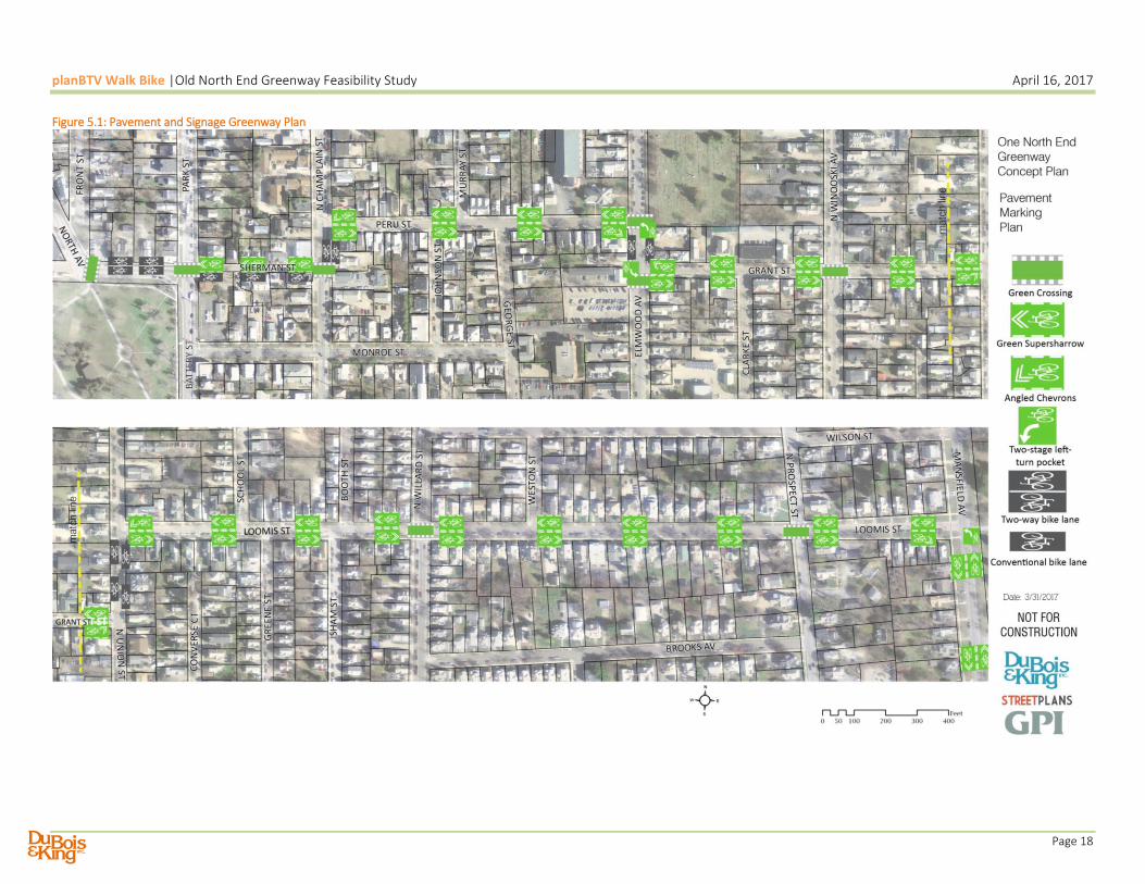
5 Next Steps
The City of Burlington Department of Public Works is working to develop standards for greenway branding, signage and pavement markings, with potential “quick build” rapid implementation of the ONE Greenway in the summer of 2017. The plan on the following page shows the proposed signage and marking concept. Quantities for the signs, crossings and pavement markings are provided in the table below. Table 5.1: Greenway Quantities
Item Quantities Notes Wayfinding Signs 4 each At either end and at N. Union
Guide Signs 6 each At each directional change
Green Crossings 242 ft At each non-stop controlled crossing
Intersection Guides 132 ft At stop controlled crossings
Super-sharrows 52 each Every 300 ft +/-
Bicycle Lanes 730 ft Elmwood and Sherman (contraflow)
Protected Bicycle Lanes 750 ft Sherman, N. Champlain and N. Union
New Pavement 650 sq ft Park/Sherman Intersection
Stormwater Curb Ext’ns 6 each 2-Loomis, 2-Grant, 2-Peru
RRFB Signs 1 each Crossing of Sherman to Battery Park
Speed humps or lumps 6 each 2-Loomis, 1-Grant, 2-Peru 1-Sherman
Street trees 16 each Locations to be determined
Cost information from recent installations should be assembled prior to plan implementation. Costs for each item will depend heavily on mobilization costs, whether or not this is combined with other projects, and implemented by City forces. The ONE Greenway can be implemented with minimal impacts on traffic circulation and parking; and incorporate green streets features such as street trees and green stormwater curb extensions as funding permits.
planBTV Walk Bike |Old North End Greenway Feasibility Study April 16, 2017
Page 18
Figure 5.1: Pavement and Signage Greenway Plan