Old harbours in northern and western Scotland
88
Proc Soc Antiq Scot, 117 (1987), 265-352 Old harbours in northern and western Scotland Angus Graham (1892-1979) and Joanna Gordon* CONTENTS Introduction . . . . . . . . . . . . . . . 265 The north-east coast: Inverness to Duncansby Head . . . . . . . . 267 The north coast: Duncansby Head to Cape Wrath . . . . . . . . 309 The north-west coast: Cape Wrath to Loch Linnhe . . . . . . . . 322 The south-west coast: Loch Linnhe to Loch Fyne . . . . . . . . 331 Appendix 1: Capstans, mooring posts and iron fittings of piers . . . . . . 345 Appendix 2: Alphabetical index of sites . . . . . . . . . . 348 INTRODUCTION The purpose of this paper is to carry forward, to the north and west, some studies already made of old harbours on the adjoining coasts (Graham 1968; 1969; Graham & Tmckell 1977; Graham 1979a; 1979b; 1984). The part of the coast covered by the present study runs northwards from the opening of the Inverness Firth and then westwards and southwards, returning as far as the head of Loch Fyne. The review was not carried further into the Clyde approaches for the reason that the estuary ports have undergone such extensive industrial and commercial development that useful evidence of their earlier condition can now hardly be looked for. The terminal date has been set at 1850 to take advantage of the Parliamentary Report on Tidal Harbours that was published in 1847. Whereas the first two of the earlier studies were based on their author's observations of existing structural remains, the present paper is based on documentary evidence, much of which was collected and reviewed by the original author. This has been supplemented by some further work, including visits to 110 sites, by the surviving collaborator. Descriptive notes are presented of those harbours which possess historical backgrounds or regarding which some significant fact is recorded. A great many sites of little general importance are listed with references and brief comment. The larger harbours are identified in the text and on the maps by small capitals, while the lesser sites are denoted by lower case Roman type. In the text, the name of each site is followed by its national grid reference. In fact, so much of this coastline is so well provided with minor customary landings, used by local fishermen and traders, that an attempt to include them all would collapse of its own weight. For example, inspection of the Ordnance Survey [OS] maps, particularly of Gaelic speaking areas, will disclose a very large number of coastal place-names containing the element 'port'. For a similar reason, the review as a whole has been confined to the mainland. The sites are taken in topographical order in a counter-clockwise direction, with an alphabetical list in Appendix 2. *33 Russell Court, Cambridge
Transcript of Old harbours in northern and western Scotland

Proc Soc Antiq Scot, 117 (1987), 265-352
Old harbours in northern and western ScotlandAngus Graham (1892-1979) and Joanna Gordon*
CONTENTS
Introduction . . . . . . . . . . . . . . . 2 6 5T h e north-east coast: Inverness t o Duncansby Head . . . . . . . . 2 6 7T h e north coast: Duncansby Head t o Cape Wrath . . . . . . . . 3 0 9T h e north-west coast: Cape Wrath t o Loch Linnhe . . . . . . . . 3 2 2T h e south-west coast: Loch Linnhe t o Loch Fyne . . . . . . . . 331Appendix 1 : Capstans, mooring posts and iron fittings of piers . . . . . . 345Appendix 2 : Alphabetical index o f sites . . . . . . . . . . 3 4 8
INTRODUCTION
The purpose of this paper is to carry forward, to the north and west, some studies already madeof old harbours on the adjoining coasts (Graham 1968; 1969; Graham & Tmckell 1977; Graham1979a; 1979b; 1984). The part of the coast covered by the present study runs northwards from theopening of the Inverness Firth and then westwards and southwards, returning as far as the head ofLoch Fyne. The review was not carried further into the Clyde approaches for the reason that theestuary ports have undergone such extensive industrial and commercial development that usefulevidence of their earlier condition can now hardly be looked for. The terminal date has been set at1850 to take advantage of the Parliamentary Report on Tidal Harbours that was published in 1847.
Whereas the first two of the earlier studies were based on their author's observations of existingstructural remains, the present paper is based on documentary evidence, much of which was collectedand reviewed by the original author. This has been supplemented by some further work, includingvisits to 110 sites, by the surviving collaborator. Descriptive notes are presented of those harbourswhich possess historical backgrounds or regarding which some significant fact is recorded. A greatmany sites of little general importance are listed with references and brief comment. The largerharbours are identified in the text and on the maps by small capitals, while the lesser sites are denotedby lower case Roman type. In the text, the name of each site is followed by its national grid reference.In fact, so much of this coastline is so well provided with minor customary landings, used by localfishermen and traders, that an attempt to include them all would collapse of its own weight. Forexample, inspection of the Ordnance Survey [OS] maps, particularly of Gaelic speaking areas, willdisclose a very large number of coastal place-names containing the element 'port'. For a similarreason, the review as a whole has been confined to the mainland. The sites are taken in topographicalorder in a counter-clockwise direction, with an alphabetical list in Appendix 2.*33 Russell Court, Cambridge

266 | SOCIETY or ANTIQUARIES OF SCOTLAND, 1987
It may be thought that this method of treatment tends to give undue importance to the sites ofthe eastern seaboard but two points must be considered here, namely the physical character of thecoast itself and the quality of the associated hinterland. The manner in which the Atlantic seaboard isbroken up and penetrated by long sea lochs is sufficiently well-known, and was obvious enough evento compel the notice of the invading Romans. Tacitus (Tacitus, 10) describes this in singularlyapposite language. 'Nowhere', he says, 'does the sea rule more widely, many tidal currents settinghither and thither; nor does it rise as far as the shore and the ebb, but flows far inland, going round andabout as if in its own domain' (. . . nusquam latius dominari mare, multum fluminum hue illucferre,nee litore tenus adcrescere et resorberi, sed influere penitus et ambire, etjugis etiam montis insere velutin suo). These great arms of the sea, and the multitude of lesser but often considerable inlets, haveprovided the very large number of natural havens in which fishing boats could be based or could findtemporary shelter, and light cargoes of commercial craft could be worked by rowed boats or over abeach. Such undeveloped customary landings are not, of course, peculiar to the Atlantic seaboard asthey occur equally on the north and east coasts and call for the same treatment there. The influence oftheir respective hinterlands on the eastern and western coats is likewise of considerable importance.The contrast between the modest prosperity of the eastern shore, enjoying tolerable conditions foragriculture and comparatively easy access to southern and overseas markets, and the aptly named'wet desert' that backs so much of the west, strikes home at once and need not be stressed further.
In the course of the harbours' development a series of phases may be seen. Who first caught fishin these waters, or at any rate caught them from a boat rather than in a land-based trap, is a questionto be put to prehistorians; but fishermen must have been at work from very early times, originally nodoubt for subsistence. Their activities would naturally have given them a thorough knowledge of allpracticable landings, as well as of convenient stretches of beach for boat-work and, in due course, ofsuitable sites for settlement. As culture advanced to the stage of supporting a class of primitive tradersand pirates, perhaps not readily distinguishable, such incomers would rapidly acquire whatever oflocal lore as promoted their own purposes; and thus the mariners who served the overseas trade ofregular medieval merchants may well have inherited the experience of 4000 years or more. At thesame time fishing retained fundamental importance, and sometimes was still, no doubt, carried on ina primitive fashion. A post-medieval phase, in which powerful interests were playing an increasingpart in commercial affairs, leads on, in the 18th century, to one typified by the development andimprovement of rich men's estates; and among the improvements entailed were the building ofharbours for boats at regular fishing stations, a movement encouraged by the frequency with whichlarge shoals of herring visited certain areas at this time. As a special case of such improvement theremay be seen the establishment of coastal settlements accommodating some clearance victims, whoseland had been taken for sheep-farming. The connection between improvement, so well-known as anagricultural phenomenon, the development of fishing stations and their harbours and the institu-tionalization of the landed proprietors' initiatives appears in the original form of the name of the bodywhich later became the British Fisheries Society. The joint stock company of 1785 was entitled, TheBritish Society for extending the fisheries and improving the sea coasts of the Kingdom (Dunlop 1952,1). The east coast was to see more of the lasting improvements, but the Society began by selecting awest coast site - Ullapool - on which to found a fishing port and build a harbour.
Ferry terminals, too, were further developed at this time, and constituted essential links in allcoastal routes in northern Scotland until the present century, while some served, and have survivedstill to serve, fishermen and traders. The latest phase of the small harbours' history has been theirobsolescence in the face of steam navigation and good roads. Fishing, however, seems to havemaintained its importance as in all previous history, while ferries are only now, with the soleexception of Corran, finally disappearing.

GRAHAM AND GORDON: OLD HARBOURS IN NORTHERN AND WESTERN SCOTLAND 267
THE NORTH-EAST COAST: INVERNESS TO DUNCANSBY HEAD (illus 1)
The east coast may be seen as consisting of three contrasting sections. From Inverness toGolspie much of the shoreline is flat and sandy, though there are rugged outcrops. The nearhinterland, especially the Black Isle, is agriculturally productive. It is, however, deeply incised by theMoray, Cromarty, and Dornoch Firths, and Loch Fleet. From Brora to Wick the coastline is rocky,rising to impressive cliffs where the Ord of Caithness meets the sea above Berriedale. Small areas
D u n robinBONAR Newton - / GolspieB R I D G E Point vCa /UTTLEFERRY N.8, S
MEIKLEFERRY
'DORNOCH. _. - SHORE
A r dmore
ILLUS 1 Map of the north-east coast

268 | SOCIETY OF ANTIQUARIES OF SCOTLAND, 1987
only of agricultural land exist near the mouths of some rivers, in a few of which there are harbours.The characteristic small harbour site of this coast is the 'goe', a fault in the cliff-line, making a narrowinlet only to be reached by a steep track or even steps, down as much as 300 feet from inhabited levels(illus 2). The northern third of the coastline, from Wick to Duncansby Head, backs on to the plain ofCaithness, bleak indeed, but always more habitable than the mountains of the south-west. The sandsof Sinclair's Bay and Freswick Bay interrupt the rocky shoreline, and harbour sites, other than theproblematic mouth of the River of Wick, are restricted to small pockets in the rocks.
In the southern section Inverness has some history of maritime trade, but most harbour workson the shores of the firths relate to the development of a system of communications for an area ill-served by roads until very recent times. Ferries for people, animals and merchandise are numerous.The great development of herring fishing in the 18th and 19th centuries led to some harbour building,for instance at Cromarty and Portmahomack. In the two northern sections, however, most of theharbours were built primarily to serve that fishery. There are small customary landing-places, some,like Sarclet, in narrow and precipitious 'goes', where piers, breakwaters, spending beaches, and fish-curing and store houses were expensively constructed, and used, at most for a few decades. Wick,though much needed as a harbour of refuge, proved unsuitable for that purpose, and achieved onlymodest development as a centre of trade and communications.
The ferry crossings of the firths in the southern sections were less exposed to wind and sea thanwere the harbours of the North Sea coast, but local hazards dictated in most cases the provision of twoterminals at each end. Kessock is, however, the only ferry to have had four piers of equal, or nearlyequal, size and solidity (of which three survive). Emergency piers elsewhere were often smaller
ILLUS 2 Whaligoe: the steps from the southern lip of thegoe

GRAHAM AND GORDON: OLD HARBOURS IN NORTHERN AND WESTERN SCOTLAND 269
wooden structures, many of which have disappeared. Some ferries developed at their main terminalspassenger traffic and commerce with distant ports. Such development was characteristic of ferriesnear the sea openings of the firths, because these were less liable to silting as well as being close to themain sea routes. On the other hand, some passengers and much of the local produce had further to goto reach, for instance, Chanonry of Ross than Dingwall, hence the efforts kept up well into the 19thcentury to build a harbour even at Dingwall.
INVERNESS NJ 665 460 (illus 3 & 4)SummaryDevelopment of the harbours of Inverness up to 1850 took place in three main stages, focusing
successively on particular sections of the river banks, the sites respectively of the three harbours beingmentioned in the New Statistical Account. From the earliest times to the 17th century, the right bankat the Maggot, where fords connected the beginnings of the town with the Merkinch and Kessockferry, served fishermen, shipbuilders, and traders with the outside world. The second phase, ofextension downstream on the right bank, saw the siting of the Cromwellian Citadel between theMaggot and the sea, in a position to control both access to the original harbour and the Merkinch roadto Kessock. The new harbour in the south ditch of the Citadel, and the Old Quay as re-planned before1821, failed to accommodate all the developments of communications and trade as these expandedafter 1745. In the third phase, the Merkinch ceased to be an island, facilitating development on theleft bank, with Thornbush Quay as its focal point.
It is idle to speculate on the origin of the port at Inverness, as historical records fail us; at thesame time, the site obviously possesses such natural advantages as would have attracted sea-goingpeople at any period. The delta of the River Ness provided, up to the late 18th century, more than onemouth for the river. Its conformation, even the numbers of islands, may have changed considerablyfrom time to time. The main island in medieval and early modern times was the Merkinch, thenorthern tip of which forms the south shore of Kessock narrows, at the mouth of the Beauly Firth.Views of Inverness in the 18th century, including the drawing by P Sandby made in 1774, show waterflowing in the Nabon, between the Merkinch and the left-bank mainland. The crossing of the Nabonat Bowbridge, later called 'The Stones', was wet within the memory of persons alive in 1881, and thearea on the right bank known as the Maggot was thought to have been an island in the 16th century(Ross 1883, 66, 67). Avery's map (1725-30) also shows the Merkinch as an island (illus 3). Fordsexisted, one near the head of the tide above the bridge commanded by the Castle, and two to theMerkinch, near the precursors of the modern Waterloo and Railway bridges. Wordsworth (1982,388-9) has recently suggested that the level ground on the right bank near to these fords and to theparish church is likely to have been the site of the burghal nucleus. A settlement here would alwayshave enj oyed shelter among the islands of the river mouth for its boats, and access at a distance of lessthan two miles to the safe and extensive anchorage in the Kessock narrows, on a natural east-westtraffic route linking Moray with the Beauly district and Strath Farrar. Supplies of shipbuilding timberwould also have existed up-country, with the River Ness available for the driving of logs. In view ofthese facts it is unlikely that so attractive a potential port would have lain unused until an Anglo-Norman burgh was created by a 12th-century King of Scots; and it is probably safe to think of acustomary landing or landings in the estuary as having long been used by communities of fishermen,traders or pirates. In historical times, again, whatever may have been the date of the town's erectionas a Royal Burgh - a point which does not seem to have been clearly established - it is hard to imagineany trading community, irrespective of its legal status, failing to provide itself with organized shippingfacilities of one kind or another. This seems to apply to Inverness with particular force in view of itslater reputation as a shipbuilding port.

270 | SOCIETY OF ANTIQUARIES OF SCOTLAND, 1987
PLAN OF THE OLD AND NEWINTENDED HARBOURS OF INVERNESS
ILLUS 3 Inverness: details copied from three early plans:a Plan of the old and new intended harbours of Inverness, c 1729, based on a plan inthe archive of the Highland Regional Library, Inverness, made available by cour-tesy of Mr A B Lawson. This is a larger scale version of the central harbour area asprojected according to the plan initialled A.M. (INVMG 244), differing, however,in that this is the only record seen of a sluice being thought of as a way of scouringthe old harbourb Plan of the citadel ditch harbour, 1841. No sluice appearsc The mouth of the river Ness in 1730, based on Avery's plan. The Merkinch is anisland and the citadel ditch is open all round
The history of the harbour as it developed in later times should be viewed in the light of apassage in the New Statistical Account (NSAS, Parish of Inverness, V14, 28) which states that threeharbours were made at different times in the mouth of the River Ness. The writer may be supposed tohave had in mind (1) the Old Quay, situated in modern terms between the Waterloo Bridge and the

GRAHAM AND GORDON: OLD HARBOURS IN NORTHERN AND WESTERN SCOTLAND 271
railway viaduct; (2) the Citadel Quay, adjoining Cromwell's fort; (3) Thornbush Quay, on the leftbank of the river and further downstream. The burgh presumably enjoyed full liberty in the choice ofsites for its harbours, as a charter of 1641, which purports to confirm earlier unquoted charters datingback to William the Lyon (APS 5,538), specifies as burgh property '. . . all portes, heavines andcruikes' on both banks of the water of Ness, from a stone known as Clash na haggag to the sea,together with the fishery landing places at North and South Kessock and the right of working theferry.
The position of the Old Quay is given by A D Cameron (1975, 232) and his conclusion issupported by Wood's Plan of Inverness, of 1821, and the Report of the Boundaries Commission of1832. Earlier evidence comes from a Macfarlane document of the 17th century (Macfarlane GeogColl, 1, 204), which alludes to a road to the harbour distinct from another leading to Kessock ferry,the former presumably following a line corresponding generally with that of Church Street; whileSlezer (1693, pi 34) shows in his view of Inverness three good-sized boats berthed at the point inquestion with smaller boats beached nearby. G Cameron (1847, 33) would appear to place the sitefurther upstream, as he states that the 'oldest part of the harbour was built in 1675', and this wouldimply a connection between it and the seven-arched masonry bridge near the Castle, which was, infact, built at about that date - 'lately' as Slezer put it in 1693 (Slezer 1693,44). However, a bridge wasrecorded in the early 17th century (Macfarlane Geog Coll, 2, 403) and in 1596 a bridge and harbourwere both in need of repair (Marwick 1866, 1, 489) all of which suggests that G Cameron confusedtwo bridges, applying to the one mentioned in 1596 the date 1675, which belongs properly, as hasbeen said, to the stone bridge near the Castle. No weight need therefore be given to his dating of theharbour, or to whatever this might seem to imply in respect of position.
For the old harbour's true, or at least approximate age, evidence is given by the record of 1596,as quoted above. That is to say, the works, whatever they were, must presumably by that date havebeen standing for a longish time to have earned the epithet 'decayit', and to require an impost for theirrepair. This fact might well put their origin back to the beginning of the century or earlier. Repairswere again being discussed in 1660 (Marwick 1878, V3, 504). The harbour of the early 17th centurywas described as treacherous, and able to take only small craft (Macfarlane Geog Coll, 2,504) 'portuinfido et minorum capaci'.
The second harbour of the series envisaged by the New Statistical Account was built in the thirdor fourth decade of the 18th century, A D Cameron dating it to between 1725 and 1732 (1975, 223)and G Cameron (1847, 60) to 1738. G Cameron writes of an 'excellent beach' about 160 yd (146 m)long extending downstream from the Old Quay - no doubt the one on which Slezer showed the boatsdrawn up - and he places the New Quay at the end of this, close to the remains of the Citadel. Thislatter faced the river on the west, and was enclosed on the north, east and south by a wet ditch: A DCameron, whose account of the harbour will be followed from this point without further individualreferences, describes the New Quay as lying 'at right angles to the river outside the southern defensivemound', and notes that it is shown on Hume's Plan of 1774 (Hume 1774). Precisely to what extent theadjoining part of the moat was included in the works is not clear, but Slezer's view shows that in 1693,that is to say before their construction, entry to it was blocked by a row of stakes (Slezer 1693).According to A D Cameron, this harbour was never completed, as the funds ran out, though it wascertainly in use and was repaired at some date after 1803. A plan in Inverness Museum, dated 1729and initialled 'A.M.', sets out fully a project for developing a harbour in the moat. A basin at theopening into the south ditch of the Citadel was to be fed with and scoured by incoming tide-waterentering the north ditch from seaward and flowing round by the east (landward) ditch. Sluices areshown both at the opening into the north ditch and at the closure of the new harbour from the rest ofthe south ditch. It was calculated that nearly 60000 tons of water would run off from between the

272 | SOCIETY OF ANTIQUARIES OF SCOTLAND, 1987
sluices in three hours. Hume's plan shows that by 1774 the opening of the south ditch had beenwidened for use as a harbour, but neither this nor Hume's plan shows any sluices. Eraser (1910,100 &102) described the Citadel and published a plan of its conversion in the 1730s of the south ditch as aharbour, quoting a cost of £2700. Such a sum may well have been insufficient for the full realization ofthe 1729 scheme.
At the end of the 18th century the Statistical Account described the harbour, presumably thewhole complex within the estuary, as being 'safe, commodious, and kept in excellent repair' (SAS,Parish of Inverness V9, 617). While it is possible, partly in view of what is known of the TownCouncil's attitude in immediately succeeding decades, to suspect that the writer of 1793 wasinfluenced by a local patriotism, the harbour was not totally neglected. The New Harbour as markedon Wood's plan in 1821 occupied over half the length of the south ditch of the Citadel, with a bridge atits head giving access to buildings on the Citadel site. If this New Harbour was indeed only a partialrealization of the 1729 plan, lacking the scour of its proposed sluices, then its appearance on Leslie'splan of 1846 as 'Old Tidal Basin', and the need for new tidal basins as also shown on Leslie's plan, tothe east, up a new cut between the Muscle Scalps, and on the west bank to the south of ThornbushQuay, would be readily explicable. The Harbour Commissioners' statement in 1847 that the harbour'with the exception of Thornbush Quay and a small dock near the Town, remains in a state of nature'(Harbours) may be in part a reflection of the failure to develop new tidal basins, such as wereenvisaged in connection with Leslie's plan, but never built.
The 'small dock near the Town' referred to by the Commissioners (ibid, xxxvi) was probably theold tidal basin in the south ditch of the Citadel. In the same year, however, G Cameron's reference toand Old Quay 160 yd (146 m) upstream nearer the town draws attention to a stretch of the right bankof the River Ness of importance to trade and communications from very much earlier times. Ross(1893, 66) recorded memories of persons who had seen, possibly in the late 18th century, boatspassing as far as the foot of Chapel Street, an area connected with the Castle by a road, now ChurchStreet, along the line of which the town had grown up. The Maggot Ditch shown in Hume's plan of1774 could have taken only small boats so far, and the line of the river bank was altered at the time ofthe building of the Black Bridge (a forerunner of the Waterloo Bridge) in 1808. Wood's plan of 1821shows the right bank below this bridge cut back to run due east across the former mouth of the MaggotDitch before turning north, then east-south-east, then north again for 160 yd (146 m) and finallyforming a similar but larger projection into the tideway at the mouth of the tidal basin in the Citadelditch. An Admiralty survey of 1845 shows no change (Harbours, App C 376). A Ministry ofTransport plan (RHP 1117) labels the 30 yd (27-4 m) stretch running northwards from a point 50 yd(45-7 m) east of the bridge 'Old Quay', and the longer stretch from there to the Citadel Quay'Wooden Quay'. Both abuttments of the tidal dock in the Citadel ditch are shown as stone quayshaving river faces 70 yd (63-9 m) in length, as described by Eraser (1899, 93-102).
Thornbush Quay, the third of the harbours covered by the passage quoted above from the NewStatistical Account stood on the west side of the estuary some 600 yd (548 m) below the Citadel Quayand is shown on a plan surveyed in 1844 as a stretch of riverbank wharfage about 180 yd (164-5 m) inlength (Harbours, 376 opp). Its origin and functions cannot, however, be considered in dissociationfrom fresh factors introduced by the construction of the terminal section of the Caledonian Canal,about which something must accordingly be said here (see also Harbours, xxxvi and Lindsay 1968,'144). The Canal was authorized by Parliament in 1803, and was begun in 1805 under T Telford asprincipal engineer with W Jessup as consultant. The terminal works consisted of a sea-lock atClashnaharry, giving access to a lower basin, and from this a second lock led into Muirtown basin,shown on the plan published by the Harbour Commissioners as measuring about 900 yd (822-6 m) inlength by up to 200 yd (183 m) in breadth. It was intended primarily to serve the Inverness trade, and

GRAHAM AND GORDON: OLD HARBOURS IN NORTHERN AND WESTERN SCOTLAND | 273
the New Statistical Account of 1845 (NSAS Inverness, V14,28), notes that ships too large to negotiatethe estuary were worked from the Canal's wharves. The basin was almost completed by 1807, butdifficulties encountered in the building of the sealock delayed progress until 1811, and the canal as awhole was not opened until 1822. Large scale repairs became necessary in 1843, and the water-waywas finally reopened only in 1847.
The building of the Caledonian Canal had important effects on the fortunes of Invernessharbour. Constructional work on the terminal locks and basins brought much new business to itsquays, but the Town Council, since ceasing work on the Citadel Quay, had consistently scampedexpenditure on the harbour's upkeep, and the fresh revenue was accordingly absorbed into theCommon Good while the harbour was allowed to deteriorate. As a result, after the completion ofMuirtown basin, shipping tended to resort to it rather than to the Town's quays (Harbours, xxxvi) andit was evidently the threat of competition from this quarter that led the council to repair the CitadelQuay and to build Thornbush Quay in 1813-17. This latter work accommodated ships of up to 250tons, and according to the Town Clerk's evidence to the Tidal Harbours Commissioners, furtherunspecified improvements were made in 1813-18, 1826, and 1837-45 (ibid). Nevertheless, theCommissioners in their report blamed the Town Council for failing to take advantage of such naturalfeatures as a 14 ft (4-25 m) rise of tide and the absence of a bar. Again, two Admiralty surveyorspointed in their evidence to insufficient outlay on maintenance, and emphasized the need fordredging in the estuary's channel. They stated that the chief cause of navigational difficulties was thesteep angle of the river's descent from the level of Loch Ness, the fall amounting to 45 ft (13-7 m) inseven miles (11 -2 km); as a result of this, the tide reached barely two miles (3-2 km) up the estuary, theeffect of the flood water going out with the falling tide was consequently feeble, and the river's strongcurrent, thus insufficiently checked, was to bring down large quantities of sand and gravel. Theyinsisted that dredging was necessary to lessen the angle of the estuary bed's descent.
The harbour was eventually reorganized, a Harbour Trust was established, and in 1847,J Mitchell was appointed Harbour Engineer. It was Mitchell's reforms that gave the harbour its latershape, but most of the work was done after the terminal date of this study. In summary, the channelwas dredged to a depth of 21 ft (6-4 m), Thornbush Quay was extended, and on the west embank-ments were built, one stretch protecting Capel Inch and another carrying a tow path to Carnac Point.In the 1880s, the Citadel Quay was repaired, Shore Street Quay was built by the railway companywhen its viaduct cut off the Old Harbour from the Citadel Quay, and a groyne was constructed to givethis area improved shelter.
Some details of the maritime trade to which this harbour formed a background for severalcenturies are set out by A D Cameron (1975,226). He notes that medieval charters granted the burgha monopoly of trade with the country to the north and west, reserving the right of the burgesses to buyand sell timber, hides, fish, wool and cloth. Nearly 5000 hides were exported in 1406, and in so far assuch products came from the Highland region, it is certain that lack of roads necessitated theirtransport by sea. Again, J Steuart, a prominent local merchant who flourished in the earlier part ofthe 18th century, was trading with a dozen small ships to Rotterdam, Lisbon, Barcelona and Leghorn,as well as to the West Highlands and England; his chief exports were skins, salt cod and herring to theBaltic and Holland, and salmon and herring to France and the Mediterranean. In 1720, a barquecarried skins to Danzig and returned with a mixed cargo of tarred rope, flax, linen, iron, glass andsoap. The same owner was smuggling on the west coast. In addition to this export and import trade,shipbuilding was evidently an important local industry, a shipyard being established, in particular, atThornbush Quay. This comparatively recent development is, however, far outrun by what seems tohave been the local industry's scope in the middle of the 13th century. Matthew Paris (1880, 5, 93)recorded that in 1249 a French crusading count, Hugh de Chatillon, had a ship, described as

274 | SOCIETY OF ANTIQUARIES OF SCOTLAND, 1987
'marvellous', built at Inverness in which he and his companions from Boulogne, Flanders and theLow Countries could be carried oversea (transfretari). A vessel which could accommodate, as wemust suppose, at least four knights, with retainers to an unknown number, and possibly horses aswell, on a voyage from, say, Boulogne to a Mediterranean port, naturally had little in common withthe local trading craft of the 18th century, which A D Cameron rates in general, at not more than 50tons. Nor was this the only overseas order executed in the 13th century, as G Cameron states, thoughwithout giving his authority, that another French count had a replacement built for a ship lost inOrkney. On the other hand, Paris' language (navem mirabilem. . . paraverat in Ylvernes) could applyto work not done by a native shipyard but by a gang of skilled Low Country shipwrights sent toScotland for the purpose, and taking advantage of a supply of suitable timber conveniently close totide water. An analogy might be seen in the practice of the English 18th-century iron masters, whoshipped their ore to the West Highlands and built smelters there to exploit the fuel supplied by thelocal woods.
StructureModern construction has completely obscured the layout of the original harbour of Inverness on the
site of the inlet downstream from the Maggot. Portland Place, the eastern exit from the Waterloo Bridge,preserves the line of the embankment from the east end of the 1808-49 Black Bridge across the mouth ofthe Maggot inlet to the point at which the Old Quay diverged (in 1821) at an oblique angle north-eastwards,as Shore Street does today. The Harbour Office, the abutment of the railway viaduct and Shore StreetQuay stand today on made ground which covers over the whole site of the Old Quay, and is protected bythe later 19th-century groyne. This quay was only 30 yd (27-4 m) long, according to the Ministry ofTransport's 1843-4 plan and would not have extended as far downstream as the end of the groyne. Even thefurther 200 yd (183 m) of former wooden quay leaves room for G Cameron's 'excellent beach', 160 yd(146-2 m) long in 1847, to have occupied the site of the upstream part of the present Citadel Quay.
Thornbush Quay retains, beneath a modernized surface, much visible masonry datable probably to1813-17, all of red stone blocks in courses. It is an irregular rhomboidal structure, about 15 ft (4-5 m) high.On a foundation course of thin stone blocks, set vertically, rest 12 courses of large rectangular blocks,
ILLUS 4 Inverness: Thornbush Quay; the slip at the upstream end

GRAHAM AND GORDON: OLD HARBOURS IN NORTHERN AND WESTERN SCOTLAND | 275
forming a face about 168 yd (153-5 m) long, slightly shorter than that of the foundation course upon whichthe main structure is set back a few inches. The downstream end of the Quay, battered slightly from thenarrow platform on which it is set back from the edge of the foundation course, has a flight of steps, onlyc 1 ft (0-301 m) wide, descending from the top back corner to the river front edge. At the upstream end ofthe Quay, a slip 50 ft (15-2 m) long descends gently to the beach (illus 4). Two stone pawls remain in place atthe back of the quay; another lies uprooted, showing its massive foot (see illus 51).
KESSOCK FERRY, South NJ 655 473, North NJ 655 478Though not, of course, physically a part of Inverness harbour, Kessock Roads provided
anchorage for ships of deep draught trafficking in the estuary. Some might reach the quays at hightide, while others could use tenders. The river mouth opens at the narrows which separate the Morayand Beauly Firths, and the anchorage lay immediately to the west, giving shelter, deep water, andgood holding ground for anchoring. The right to landing places for fisheries on both sides of the firth,and also the working of a ferry, was secured to Inverness by a charter of 1641; and the ferry itself wasan important feature of the site. A plan surveyed in 1845 (Harbours, 376 opp) shows, on the southshore, approached by a road from the town, a pier marked Ferry, and on the north two piers, onesimilarly titled. The pier on the south shore was built in 1825-6 by Sir William Fettes, and a witnessstated to the Tidal Harbours Commission in 1846 that it served the ferry very well, but occupied thebest holding ground and anchorage owned by the Port of Inverness. An early edition of the OrdnanceSurvey 1:2500 map (1870) shows two piers on either shore, the west pair being linked by a linemarking the course of the ferry.
StructureOne sloping pier remains at South Kessock, approximately 220 yd (2Q1 m) long and 20 yd (18-3 m)
wide. Neat courses of red stone blocks show on the east side below the modern coverings. About 200 yd(183 m) to the east, a section of the bank between the shore and the road is faced with timbers, possiblyindicating the site of the second south pier. On the north shore, there are two piers. The western one hasmodern coverings, but that to the east appears to be in its original form, closely resembling the south pier.
MUNLOCHY BAY NH 690 525 (at mouth)This long, narrow and mainly tidal inlet probably possessed some local importance as it is
commended as a good natural haven in a document of the early 17th century (Macfarlane Geog Coll,2,554). The record is of ships 'for daily passages into Moray' being berthed at Munlochy in preferenceto 'Chanrie', where there was no harbour: (see Chanonry Point p 277). The haven of Munlochy maythen have been less silted up than it is now, the settlement being at present well away from deep wateracross acres of tidal mud-flats and half a mile of pasture, or the anchorage may have been near themouth of the bay, sheltered except from the south-east.
AVOCH NH 705 551In 1795 good anchorage was noted between Seatown of Avoch and Castletown Point, and
except in southerly or south-easterly gales craft could lie safely and work cargoes on Seatown beach(5,45 Avoch, V15, 613). A pier was built in 1814 (Harbours, xxxviii). The OS 1:2500 map of 1873shows a 30 yd (27-4 m) long quay, from the west end of which a pier projects just over 56 yd at rightangles, ending in a return head parallel with the shore quay, also 30 yd (27-4 m) long. Thesemeasurements correspond with those of the harbour at Avoch which T Telford is recorded as havingbuilt between 1813 and 1815 (Gibb 1935, 311).
StructureThe modern road (A 832) from Inverness to Fortrose is separated from the head of Avoch harbour
only by a sea wall. The damaged footage of this wall is of red stone block construction, like that of the inside

276 | SOCIETY OF ANTIQUARIES OF SCOTLAND, 1987
face of the pier to the west. There are flights of steps inset in this face near each end. Part of the face,towards the sea end, is built of smaller dark red blocks, neatly coursed and much worn. The whole face isslightly battered, and is in much better repair than the sea wall, though broken at the corner where the twoonce joined at an oblique angle. The debris here may be that of a former slipway. Modern extensions havereplaced or obscured the rest of Telford's harbour.
FORTROSE NH 724 563 (illus 5)To avoid confusion between Fortrose, also known as Chanonry of Ross and its neighbour
Rosemarkie, distant about a mile and a half (2-4 km) to the north-east, a word of explanation isnecessary. In the mid 17th century, Rosemarkie seems to have been in decline; a charter of 1641confirmed its amalgamation with Fortrose (APS, 5,223). The place was of sufficient importance to bemarked on Collins' chart (Collins 1776), though no harbour existed at that time. Petitions to theConvention of Royal Burghs for help in building one began in 1715, and in 1725 a voluntarycontribution by all burghs and traders was approved (Marwick 1885, V5,147,168,372). Local peoplebelieve that a harbour was built for the embarkation of troops in 1745, but no trace remains of whatwould probably have been a flimsy, hurried structure. A harbour was ultimately built in 1817(Harbours, xxxviii). Gibb (1935,311) lists a'new pier' 170 ft(51-7m) long atFortrose, and deepeningof its harbour as having been carried out by T Telford between 1813 and 1817.
StructureThe east pier, quay and west pier with head returning east-north-east, are all of large red stone
blocks. (The west pier has a modern wall, with look-out box, heightening its parapet.) The lower courses ofthe east pier look the oldest, but this could be the result of different sea-wear on the top three courses (illus5). Matching wooden pawls survive, as shown on the OS 1:2500 map (1871), one near the tip of the eastpier, two on the outer edge, below the parapet, of the west pier.
ROSEMARKIE NH 738 536All that need be added here to the foregoing note on Fortrose is that the sandy bay provided
excellent anchorage and shelter from the west. Rocks at the north-east end of the bay may have givensome shelter to craft small enough to be worked over the beach.
ILLUS 5 Fortrose: courses of red sandstone blocks without mortar. The neatness is characteristic of structures actuallysupervised by Telford

GRAHAM AND GORDON: OLD HARBOURS IN NORTHERN AND WESTERN SCOTLAND 277
CHANONRY POINT NH 750 557 (illus 6)This point formed no part of either Fortrose or Rosemarkie, though it was included in the parish
account of the latter. It carried the terminal of a ferry from Fort George and in 1840 a steamer wasmaking weekly calls (NSAS, Rosemarkie, V14, 356). Gibb (1935, 309) includes 'Channery' amongpiers constructed by T Telford in 1819.
StructureThe ferry pier is a massive, lengthy, elegant structure of large red stone blocks, 250 yd (228 m) long
and over 6 yd (5-5 m) wide. Seven courses high at the point, 110 yd (100-5 m) from the shore, where the pierturns slightly eastwards, it slopes to five courses at the tip. Only the lowest, outermost block is slightlyundercut by the sea. A parapet wall running nearly the full length of the west side, with a neatly curved buttat each end, shows slight signs of wear at about the half tide mark, the level at which so many such works areintially breached by wave action. It is secured by iron straps and a continuous central linear cramp, insections of uneven length to accommodate the uneven sizes of the blocks, held in place by flat-headed ironbolts. Two very large iron rings, on ring-headed bolts, survive near the shore end of the pier. The massivekerb blocks of the pier margin are carefully fitted, alternately long and short sides out, to form keys for thestones of the pavement, and are curved on the outer edge. The tip of the parapet wall is of five courses,including two heavy capstones, the top one neatly curved. The parapet stops a little short of the pier end,leaving an angular platform accessible from the sea on two sides. All faces of the pier and parapet wall arebattered, no doubt because this was believed to strengthen them, and certainly with fine aesthetic effect(illus 6).
CROMARTY NH 866 677Records relating to an early harbour at Cromarty are difficult to interpret with confidence as
they are apt to confound the firth itself with artificial works at the town. This is certainly true ofBishop Leslie's account (Brown 1893, 140); of a document of the early 17th century (MacfarlaneGeog Coll, 2,415), which rates the firth as safe, capacious, free of sands and shallows and providing agood bottom for anchoring (omnes denique egregiiportus laudes habef); and of the Statistical Account(SAS, Cromarty, V12, 250), with its allusion to an anchorage in the shelter of the Sutors; and of the
ILLUS 6 Chanonry Point: the ferry pier

278 SOCIETY OF ANTIQUARIES OF SCOTLAND, 1987
New Statistical Account (NSAS, Cromarty, V14,2). In earlier days the firth was called Portus Salutis,and is marked as Portus Securus on Biship Leslie's map (Brown 1893,114). On the other hand, thereference of 1592 (APS 3, 586) to regulations for the 'heaven and port of Cromarty' suggests anorganized sea-port rather than a mere roadstead or sheltered anchorage, while the chart in Collins'sPilot (Collins 1776) is ambiguous. Ambiguity ceases, however, with the positive statement that a'most commodious quay' was built in 1785 jointly by the proprietor, George Ross, and the govern-ment ; this accommodated vessels of up to 350 tons and served a ferry crossing the narrows of the firth(SAS, Cromarty, V12,250). A plan surveyed in 1839 (Harbours, App C 376) shows two parallel east-west piers and a free-standing breakwater to the west of the entrance.
StructureApparently consistent red stone block construction characterizes the present north pier, 300 ft (91-2
m) long and 20 ft (6-1 m) wide, the shore quay 220 ft (66-9 m) long, the south pier 200 ft (61 m) long and 30 ft(9-1 m) wide and the freestanding breakwater in the harbour mouth, now joined to the south pier by abridge and extended to form a deep water quay. There is a string course all the way along the curved outerside of the north pier, which otherwise rises uninterrupted to the summit of the parapet wall. This ends in asmall turret, where a light would have been useful. Steps are inset in the inner pier face, just below theturret. One wooden pawl survives near the head of these steps. There is another set of steps, descendingseawards, contrary to the direction of those just mentioned, inset in the face about halfway to the shore.Still nearer the shore quay, an arched opening in the pier has been blocked with matching stonework. Athird set of s^eps is in the quay face, at its angle with the north pier. A slip rises from the beach for 65 ft (19-7m) alongside the south end of the quay, which curves back a little at this point, perhaps to facilitate haulageto the level at which it meets the south pier. There is a fourth flight of steps inset in the curved end of thesouth pier. The whole design is elegant, and indicates, in addition, an intention to assist the working ofsmall craft in rough weather.
Udale Bay NH 713 652The Newhall Burn enters the Cromarty Firth through the sands of Udale Bay. The marshes and
small lagoons on the edge of these sands have accommodated boats up to 20 ft (6-1 m) long, one ofwhich may be seen decaying below the bridge at the angle of the B9163 road. A site resembling insome respects the 'pows' of the Solway coast, it is dominated by the remains of Gordon's Mill.
Balblair NH 701 761 formerly Inverbreckie (see Invergordon p 282)Telford recorded building piers for the Invergordon-Inverbreckie Ferry (1821, 49). Although
Inverbreckie today is an eastern suburb of Invergordon, and Avery (1725-30) marks Inverbuky Ferryon the north shore, the map issued by the Commissioners for the Caledonian Canal in 1821 (Accountsand Papers vol x 1821, 34), shows Inverbreckie at NH 701 761.
StructureThe surface of the pier slopes to low water level. The west side is neatly curved back towards the
shore. The sides of the pier are of large rough red stone blocks with no mortar visible, and the pavement isof smaller red stone blocks. There are three large iron rings in line down the centre of what was clearly nomore than a ferry terminal. This limited usage is consistent with the fact that the old cottages between thepier and Newhall Point line the road looking out to sea northwards, instead of facing one another withgable ends towards the shore in the manner of fisher people's dwellings in this region.
Alness Ferry NH 664 663A roadway between steep banks curves down to the shore. At high tide no structural remains of
the terminal are visible. The very exposed site lies directly south of and at the shortest crossing fromthe mouth of the Alness river. It may have originated as a fair weather terminal from some point on

GRAHAM AND GORDON: OLD HARBOURS IN NORTHERN AND WESTERN SCOTLAND 279
the Alness delta, perhaps the area of the present Dalmore Distillery pier, long before the building ofAlness Belle Port (see p 281). In west wind, ferries from Alness would have reached Ferryton Point(NH 670 700), where there is a large ruined building and a similar road to the shore, more easily thanAlness Ferry, or could have used Balblair as an alternative refuge.
Ferryton Point NH 680 670See above, under Alness Ferry
Shoreton NH 618 621Merely a firm area of beach, looking across to Foulis Ferry on the north shore.
ALCAIC NH 565 576Though this is in itself an unimportant place, an allusion to it in the New Statistical Account
(NSAS, Urquhart and Loggie Wester, V14,378) is of interest as evidence of the importance of inlandwaterways before roads and railways were developed. In this instance, no craft of any size could reachthe inner end of the Cromarty Firth, and goods were accordingly unloaded here into sloops before thewater shoaled, to complete the journey upstream. Similar arrangements were made on the Firths ofTay and Forth (Graham 1969, 261, 278). The OS 1:2500 map (1973) marks a disused pier 350 ft (106m) by 12 ft (3-6 m), with a slightly expanded tip, in the mouth of the Ryefield Burn.
StructureTwo courses of masonry are still visible forming a causeway through the mud at low tide, from the left
bank of the burn, which turns eastward at its mouth, to one of the channels through the estuary. Rubble isheaped up at the tip.
DINGWALL NH 562 585 (illus 7)This town, though not necessarily its harbour, was of sufficient importance in the 1570s for
inclusion on Bishop Leslie's map (Brown 1893,114). The burgh charter, obtained in 1587 from JamesVI (Macrae 1923,88), includes references to cobbles and small boats. The anomalous position of the19th-century harbour, nearly a mile from the town and at the end of a man-made canal, suggests anearlier beach landing close to the settlement, which eventually ceased to fulfil its function as a result ofthe silting up of the whole head of the firth. Alluvium brought down by the rivers Conon and Orrinseems to have created a reach of tidal islets and backwaters almost all the way from Maryburgh, andasssociated sands and shallows extend for more than three miles (4-8 km) below Dingwall. (An effectof the shallowing of the head of the firth has been noticed above under Alcaig.) It is temptingtherefore to think of the burgesses of Dingwall as engaged in a losing fight with the forces of nature,and finding their beach landing gradually becoming less and less fit for their purposes. The depressedstate of the burgh in 1773, when no harbour existed, is illustrated by a reference in the InvernessBurgh Records (NSAS Dingwall, V14, 220). Improvement seems only to have come when the canalwas cut in 1815-19. Navigable water was reached by deepening and canalizing the River Peffery. Thatthe course of this river had already been somewhat rationalized is suggested by a plan of 1777, whichin addition to marking a landing place for boats up to eight tons at the site of the later town harbour,shows the river's lower reach taking a sinuous course past the castle, much like that of the later canal(illus 7). On the plan published by Telford in 1821, the cut into which the Peffery was diverted duringconstruction of the canal is clearly marked, debouching into an area of salt marsh which retainedsomething of the form of the river mouth as it had been before the rationalization recorded in 1777. In1815, Dingwall Town Council Minutes record a contribution of £100 to the building of the canal which

280 SOCIETY OF ANTIQUARIES OF SCOTLAND, 1987
From P l a n o f D i n g w a l l t a n d s , 1777
From T e i f o r d ' s P lan of D ingwal l Cana l
ILLUS 7 Dingwall: a, copied from a plan of 1777. (Macrae 1923. By kind permission of CouncillorMacrae); b, copied from Teiford's plan of 1821
eventually cost £4365 (Macrae 1923,248). In 1828, another Minute records an effort, which failed, totransfer responsibility for the canal, then earning less than £100 a year, and in need of £800 worth ofrepairs, to the Parliamentary Commissioners (ibid, 250). In 1837, the canal was held to constitute atolerably good harbour quite close to the town, two small vessels, built and owned in the town, were

GRAHAM AND GORDON: OLD HARBOURS IN NORTHERN AND WESTERN SCOTLAND | 281
then engaged in the coasting trade, while others came with coal, lime and other cargoes, taking outgrain, timber and bark (NSAS Dingwall, V14, 220).
StructureOf the 19th-century harbour below the bridge at the head of the canal only a few uneven courses of
grey stone blocks are still visible in the face of the right bank. About a quarter of a mile (0-4 km) to the east,Old River Road preserves the line of the opposite bank of the swampy river mouth in which boat landingswere made before the canal was built. A building known as Harbour House stands on the right bank of thecanal near its opening into the Firth. From below Harbour House, the canal mouth was reconstructed in1861, and now takes a final turn to the south-east (Clew nd, 8). A short distance upstream from HarbourHouse, also on the right bank, there are remains of a timber wharf. Seven heavy frontal uprights are inplace, as are two front edge timbers, each about 7 ft (2-1 m) long and a foot (0-304 m) square, at theupstream end. It may be that this timber wharf dates only from the period of the construction of the railwaybridge, just below the Castle, when the second harbour marked on Telford's plan disappeared.
Foulis Ferry NH 600 635A disused track leads to a stretch of foreshore where there are many fragments of dressed stone
and some 30 tree trunks driven vertically into the shore near the present line of the bank.
Alness Dalmore NH 664 683The New Statistical Account for Rosskeen parish mentions a harbour at Dalmore, (perhaps on
the site of the modern distillery pier), exporting timber to the north of England (NSAS, Rosskeen,V14, 275).
Alness Belle Port NH 690 673 (illus 8)The B817 road comes right down to the shore of the Cromarty Firth immediately to the east of
the delta of the Alness River, a quarter of a mile (6-4 m) before reaching Belle Port pier. This survivescomplete, though the top surface is grassed. Both sides curve neatly out from the shore, and areslightly battered up to a rolled edge kerb which is continuous round the sea end. The corners of the seaend are mitred. One very large iron ring is in place near each corner (illus 8). Steps descendingseawards are inset in the west side near the sea end, and near the shore on the east side.
ILLUS 8 Alness Belle Port: the sole instance of an upstanding rolled-edge kerb, presumably adecorative feature
282 | SOCIETY OF ANTIQUARIES OF SCOTLAND, 1987
INVERGORDON NH 709 683
The records suggest that this was a place of little importance, except as the terminal of a ferryplying, presumably, to Balblair, for which Telford is stated to have constructed a pier in 1817 (Gibb1935, 309). A pier for passengers was built in 1821, and in 1828 the proprietor provided a harbourgiving 16 ft (4-8 m) of water at springs and 13 ft (3-9 m) at neaps (Groome 1901, sv). The NewStatistical Account of Rosskeen Parish adds some details. 'A few years ago a fine pier for large vesselswas . . . erected at Invergordon' (NSAS Rosskeen, V14, 275), presumably Groome's 1828 pier. In1837 a wooden jetty, intended to provide a depth of 10 ft (3 m) at ebb tide proved useless. In the sameyear a boat slip was constructed. Regular passenger services went to London and Inverness (ibid 275).The OS 1:2500 map of 1973 shows a west pier 250 ft (76 m) by 20 ft (6 m) with a return head extending100 ft (30 m) due east, that is at right angles to the line of the pier. From the inner side of the shore endof the west pier, a shore quay runs obliquely, north-eastwards for 180 ft (54-7 m) making an acuteangle where it meets the inner face of the east pier. This is parallel to the west pier, and its length of340 ft (103-3 m) brings the pier heads level. The east pier is 30 ft (9-1 m) wide. While less adapted forfishery or commerce than, for instance, Cromarty, the form of this harbour with both east and westpiers distinguishes it from the isolated jetty, slip or pier of most ferry terminals.
StructureParts of both east and west piers survive, much built over. Of the east pier only the land end can be
seen, the slightly battered sides finishing in a raised kerb of one course of blocks, at the edges of thepavement of granite sets. The west pier as shown on a postcard dating from before it was built over by thegas works, had only about 6 ft (1 -8 m) of its return head. A flight of steps inset in the inner face of this pierprotected originally by the return head and descending away from it, is still visible.
Balintraid NH 742 711Marked on Collins' chart (Collins 1776). A landing pier 90 yd (82-2 m) long with a return head
served Balintraid Ferry from 1820 (Harbours, xxxviii). According to Gibb (1935, 309) Telford wasworking there in 1817. The pier survives, but is breaking up. The kerb is missing from the rounded seaend, and the parapet wall of six courses is breached near its rounded tip and immediately toshoreward of its curve at the back of the return head.
NIGG NH 786 698 (Pot Burn) 796 688 (Nigg Ferry)No harbour existed at Nigg, but it was recorded in 1836 (NSAS Nigg, V14,20) that at high water
light craft could negotiate the channel of the Pot Burn, traversing the tidal Nigg Sands. The ratherlarge number of fishing boats (36) then owned in the parish was probably due to the proximity of therich fishing ground off Tarbat Ness. Nigg was a place of sufficient importance to be marked onCollins' chart (Collins 1776), perhaps by virtue of such shelter as could be obtained in Nigg Bay. NiggFerry is the northern terminal from Cromarty, and the OS 1:2500 map of 1973 marks a disusedslipway besides the modern pier.
Shandwick NH 860 745A fishing village in 1847 (Harbours, xxxviii), also marked, as 'Shandaig' on Roy's map of
1745-7.
Balintore NH 865 745A fishing village in 1847 (Harbours, xxxviii).

GRAHAM AND GORDON: OLD HARBOURS IN NORTHERN AND WESTERN SCOTLAND 283
Hilton of Cadboll NH 872 763A fishing village in 1847, said to have no harbour accommodation whatever (Harbours,
xxxviii), but in 1828 the Herring Fishery Board had agreed to assist in improving the landing place.The Commissioners' Report included a specification referring to 'the present landing slip' (ReportsCommissioners, 1830 V15,21), though Mitchell's accompanying sketch shows only a narrow openingin the rocks. The present harbour is modern, and of the structure planned by Mitchell before 1830,towards which the proprietor contributed £130, a quarter of the cost, no trace has been found.
Rockfield NH 925 829 (illus 9)Of the group of fishing villages connected with the Tarbat Ness herring fishery, Rockfield,
though only two miles (3-2 m) from its sole developed harbour at Portmahomack, is on the oppositeshore of the promontory. Harbour facilities here would often have saved a difficult passage round theNess. In 1828 James Mackay of Rockfield was one of the first three proprietors in Scotland to obtain aTreasury grant for harbour construction (see Sarclet p 299). Mitchell's plan for Rockfield pier waspublished by the Herring Fishery Commissioners in 1830 (Reports Commissioners, 1830 V15, after p27). Mackay's contribution was £107 10s, one quarter of the contract price, for a pier 350 ft (106 m)long.
StructureThe pier survives and is in use, but whereas Mitchell's plan was for it to narrow from 8 ft (2-4 m) to 4 ft
(1 -2 m) in width at about half its length, where it reached an outcrop of natural rock, the whole length todayis 10 ft (3 m) wide (illus 9). It ends at a rock outcrop, so the narrow extension was either never built in thatform, or has been changed later. Five courses of well dressed stone blocks of approximately 12 in (0-3 m) by18 in (0.45 m) rise from two base courses of flatter blocks, which project a few inches at the foot of theslightly battered west face. The east face of the pier is more noticeably shaped, rising at about 45° to theperpendicular, with a shallow concave flare outward at the foot. One kerb block on this side is loose,,revealing the rubble core. Iron cramps in the kerb and straps at wide intervals over the sides begin about
jj^,, #» T ,
« "̂4**«*»-»*
ILLUS 9 Rockfield-. Mitchell's pier, as modified in 1851

284 | SOCIETY OF ANTIQUARIES OF SCOTLAND, 1987
150 ft (45-6 m) from the shore. Many of these are now missing. The pier curves slightly eastwards beforemeeting the natural rock, and ends in a slip descending eastwards at right angles to the head, betweenrocks, a feature not shown on Mitchell's plan.
DORNOCH FIRTH
The whole firth was regarded as a unit by the Tidal Harbours Commissioners (Harbours,xxxvii); and authors of the early 17th century cite it under the names Portnecultro and Port ne Couter,as forming part of the boundary between Ross and Sutherland (Macfarlane Geol Coll, 2,437 & 3,97,100). The sites in the firth are dealt with individually below.
PORTMAHOMACK NH 915 846 (illus 10 & 11)Ordnance Survey maps show that Tarbat Ness carried a large group of fishing villages,
exploiting the rich herring fishery close to the Ness; and of this group only Portmahomack ranks as aregular port. The place name points to an ancient settlement with a church dedicated to SaintColman, but the earliest available record seems to be a charter of 1681, granting to Sir GeorgeMackenzie of Rosehaugh the right, inter alia, to make 'ane convenient harbour and sea port for smallships and boats of the said burgh of Tarbat' (APS 8, 386); but it was the first Earl of Cromarty who,while still Viscount Tarbat, ie before 1690, built the 'handsome little peer' that evidently formed partof the harbour 'for barks and small ships' mentioned in a document probably datable to the early 18thcentury (Macfarlane 1906, 1, 215). The name Seafield, which appears on Collins' chart, no doubtrefers to Portmahomack, and stands as additional evidence for a harbour at about this period. In 1790Telford, who was first employed in that year as engineer to the British Society for extending thefisheries and improving the sea coasts of the Kingdom, later the British Fisheries Society and referredto hereinafter as the BFS, reported the harbour works as 'a natural mound or pier has already beensomewhat built up' (Dunlop 1952,244). The ruinous condition of the Earl's pier is again mentioned in1793 (SAS Tarbat, V6, 425); but the harbour was still able to accommodate ships, giving 13 and 9 ft(3-9 and 2-7 m) of water at springs and neaps respectively. Further construction followed up to 1816(Harbours, xxxviii). Gibb (1935,311) states that a pier 350 ft (106 m) long was constructed by Telfordbetween 1811 and 1816. This measurement corresponds to that of the centre line of the present northpier. Telford's account of his work at Portmahomack relates exclusively to the north pier, nor is thesouth pier shown on his plan of the harbour (Telford 1821, 100). Structurally, however, it is similarenough to the north pier to make it seem unlikely to have been built much later, and also rather
P O R T M A H O M A C K : masonry on r o c k - c u t bases (not to sca le )
ILLUS 10 Portmahomack: the south pier. Slope accommodated by rock cutting and use of L-shaped blocks

GRAHAM AND GORDON: OLD HARBOURS IN NORTHERN AND WESTERN SCOTLAND 285
improbable that it is the 'handsome little peer' of 1690, though the stepped cuttings of the natural rockbase and use of L-shaped blocks described below could be called handsome without exaggeration(illus 10).
StructureThe north pier, the inner face of which is 310 ft (94 m) long, the shore quay, 300 ft (91 m) long and the
south pier, 120 ft (36-4 m) long, are all of red stone blocks some 3 ft (0-91 m) long. Both piers are 20 ft (6 m)wide. No mortar is visible between the blocks of the seaward end of the north pier or those of the lowercourses of its outer face. Either mortar has been washed out with particular effect from these sections, orother parts have been pointed or are, perhaps, of later date. Both piers rest on natural rocks, those at thebase of the south pier (probably Telford's 'natural mound'), having been cut in steps to take the courses ofblocks. Seven L-shaped blocks accommodate the changing levels as the pier slopes seawards. An iron strap3'/2 in (8-8 cm) wide was set in a channel in the surface of the kerb all the way round, and survives in part.The outer face of the north pier is 500 ft (152 m) long and presents an impressive curved bastion of cushionshaped blocks to the weather quarter (illus 11). The parapet wall, which continues the upward curve to itssummit, ends a little way short of the head of the pier. This is rectangular, and returns towards the southpier. The end of the parapet wall is in contrast, curved. Six waisted black granite pawls, 28 in (0-71 m) highand of the same maximum diameter, are ranged along the base of the parapet. The kerb stones are allcurved at their edges. There are no inset steps in the pier faces, only small iron ladders, not inset andprobably not original. The exigencies of refuge rather than assistance for routine working of boats appearto have had the dominant influence over the design of this harbour, though there is a slipway at right anglesto the inner shore end of the north pier, rising to it alongside the shore quay, and remains of anotherbeyond the south pier.
Inver NH 861 826Marked on Roy's map of 1745-7, Inver is later recorded as a fishing village lacking any
protection from the north or east (SAS, Tain, V3,390; NSAS, Tain, V14,294). In 1847 there were noharbour facilities (Harbours, xxxviii). The lagoon area at the head of Inver bay retains the shape of arivermouth,but now receives only the much canalized drainage of the area between Loch Eye, whichhas a separate outfall to the east and the sands of Morrich More, part of a delta formation east of thepresent unique mouth of the River Tain. At Inver village, boats could have been drawn up on a shoresheltered from the south and east, and with readier access to the Firth than from the marshy powshigher up.
ILLUS 11 Portmahomack: worn rusticated blocks in the weather face of Telford's north pier

286 | SOCIETY OF ANTIQUARIES OF SCOTLAND, 1987
TAIN NH 786 824It was noted in 1793 that access to Tain was obstructed by an offshore sandbank, exposed at low
tide but traversed by a channel which needed expert pilotage (SAS, Tain, V3, 390), and in 1837 thatthe only available harbour consisted of the tidal sands of the firth itself (NSAS, Tain, V14, 283).Nonetheless, harbour works of a kind must once have existed at Tain, as in 1604 the Convention ofRoyal Burghs was approached for help in repairing the 'herberis and shore', described as ruinous(Marwick 1870, 2, 180), and this language suggests at least a stretch of built wharfage on thewaterfront. Bishop Leslie marked Tain on his map in the 1570s (Brown 1893,114), as did Roy in 1747and Collins on his chart (Collins 1776). Ferry traffic converging on Tain, also well served by roadsfrom the south, resorted mainly to the Meikle Ferry, landing at the Ness of Portnecoulter, four milesto the west.
StructureAn older course of the River Tain is shown on the OS 1:2500 map of 1975 as an ox-bow south-east of
the mound from the summit of which Saint Duthus's Chapel looks eastwards across an area of the deltawhich has been drained and re-made in many forms in recent times, the left bank more recently than theright. Both river banks have stretches of timber revetment of various ages, the most substantial being a lineof 30 large upright timbers, with cross pieces, which could be the framework of a left bank quay, situatedabout 40 yd (36-5 m) north-east of the Chapel mound, near the downstream angle of the ox-bow.
MEIKLE FERRY SOUTH = FERRY POINT OF NESS OF PORTNECULTER NH 732 860
Although today this site is nearly deserted, and difficult of access, it deserves mention here, forits former importance as the southern terminal of the ferry by which the bulk of traffic to and from thenorth connected with the market and route centre of Tain (Macfarlane Geog Coll, 2,437; 3,97,100).
StructureModern construction covers most of the end of the promontory, but about 30 yd (27-4 m) of its south
eastern extremity is still faced with red stone blocks, between which no mortar is visible. The curve of thisrevetted bank disappears beneath modern work at the head of the ferry pier, which takes the form of a slip,built of similar blocks, and extending about 300 ft (91-2 m) north eastwards into the Dornoch Firth. Thewater on the south (inner) side is deeper than that outside the shelter of the slip, where, range along itslength, there is a row of six wooden posts, each at least a foot (0-304 m) square.
Ardmore NH 703 866A good natural harbour, taking craft of up to 150 tons (NSAS, Eddertoun, V14, 453). Well
placed for ferry transit to Newton Point.
BONAR BRIDGE NH 610 915
The upper end of the Dornoch firth is largely choked with tidal sands, formed, no doubt, ofalluvium brought down by the Rivers Shin and Oykell. Bonar Bridge, on the left bank of these rivers'common mouth, and just above their outflow onto the flats, is not in a favourable position to act as alanding; but in fact, in 1834, the water was deep enough for shipping and the place was described asdoing a considerable trade in both imports and exports (NSAS, Criech, V15,20). Again, in 1847 bigboats could reach the town (Harbours, xxxix), perhaps, as at Dingwall, sloops with goods trans-shipped from vessels too large to negotiate the shallows.
StructureThe right bank of the River Carron, j ust below the head of the tide, is straightened and revetted with
timbers. The adjoining downstream section is cut back at an oblique angle, and partially faced with

GRAHAM AND GORDON: OLD HARBOURS IN NORTHERN AND WESTERN SCOTLAND 287
masonry. A large drift of shingle immediately upstream diverts the main current of the Carron from thesmall pools at the foot of the bank, which is marked as a quay on the OS 1:2500 map of 1975.
A section of the right bank of the combined rivers Shin, Oykell and Carron below the modern bridge,is faced with red stone blocks in courses for a distance of about 10 yd (9-1 m). Below this again, there is aninlet made by some fallen masonry joining the upper end of an islet to the right bank. This could have beena rough dock.
Creich NH 640 882A crossing place for droved cattle (Haldane 1952, map).
Newton Point NH 712 878Improvements for the relief of clearance victims were attempted by George Dempster of
Dunnichen (1732-1818) at Spinningdale, including the commercial development of a pier at NewtonPoint (Fergusson 1934, 206). No activity beyond the unloading of coals at a later yacht pier isrecorded.
MEIKLE FERRY NH 729 869
This landing place may be regarded as having served Dornoch, just as Ferry Point of the Ness ofPortnecoulter, the corresponding terminal, served Tain. The sinking of an overloaded ferry in 1810 isremembered locally, perhaps because the 90 persons drowned were returning from a Communion inTain, and included the Sheriff of Dornoch. The pier is situated at the southern tip of the sandypromontory round which the River Evelix flows west and then south into the Dornoch Firth. A recordof 1834 (NSAS Dornoch, V15, 2) describes it as an excellent harbour where ships could lie in safetyonce they had passed the bar. This may relate to the present pier site, as there is a sand bank directly tothe south, and in 1793, besides serving as the ferry terminal, the place was used by ordinary shipping,the water being deep enough to allow them to approach the land (SAS, V3, 390 & V8, 3). Earlierhowever, the land locked area at and to the north of the mouth of the river Evelix may have beenutilized, as is suggested by a Macfarlane document datable to the 17th century (Macfarlane GeogColl, 3,100), which mentions a 'bay or inlet' with a good harbour between Skibo and Pulrossie. Thereference in the New Statistical Account to coal ships anchoring 'below the town' to discharge theircargoes is probably connected with Dornoch Shore, Ferrytown on the promontory being merely afarm name. The Parliamentary Commissioners' Report makes cursory reference only (Harbours,xxxix).
StructureThe ferry pier projects about 150 ft (45-6 m) into the Dornoch Firth from the south-east tip of the
promontory to the south of the Evelix estuary. It is a massive structure of red stone blocks, in the form of aslip with a parapet wall. The long narrow blocks set on edge to pave the surface are keyed into the kerb oflarge rectangular blocks, one of which is set with its longer sides at right angles to the pier face between eachtwo set with longer sides in line with the length of the pier. The parapet wall is set back from the westernedge of the pier, leaving a platform on the west side only a little narrower than the main platform on theeast. The wall, over 6 ft (1-8 m) high at its shoreward end, shows signs of three phases of building orreconstruction. To seaward, its end and top courses are rounded. Part of the iron strap which was boltedalong the centre line of the wall head is missing. The sides of this part of the wall slope inwards from thebase. There is less batter on the sides of the more landward looking part of the wall adjoining this. The topcourse of blocks here has a slightly curved edge. Mortar is visible between the blocks of this middle section.The third part of the wall, at its shoreward end, has the same slightly sloping sides, a top course with straightedges, but no visible mortar. The iron strap runs from the base of the wall at its shore end, up to its summitand all the way along its top centre line as far as the damaged area at the sea end. These features appearconsistent with a possibility of the middle section having, as usual, required the most repair.

288 SOCIETY OF ANTIQUARIES OF SCOTLAND, 1987
A bottle-shaped iron strap-work light fitting of some elegance is clamped to the shore end of theparapet wall top. Between the wall end and the shore, the pier surface does not slope, and carts could haveturned.
Meikle Ferry had an emergency pier at Ardvoan, about a quarter of a mile (0-4 km) along the shoreto the east, a wooden structure, used within living memory for crossing animals to Tain Friday market.(Information by courtesy of Mr and Mrs Charles Grant, Dornoch.)
DORNOCH SHORE NH 805 895The Statistical Account of 1795 states (SAS, Dornoch, V8,3) that Dornoch Shore is a safe place
for harbourage. This seems, on the face of it, improbable in the highest degree, as the town's sea frontis fully exposed to the east; but the context, which associates this shore with the mouths of the Evelixand the Fleet (Meikle Ferry and Little Ferry), suggests that the place referred to was not the town'sforeshore but some site on the tidal sands to the south, which would have been sheltered from the eastby Dornoch Point. This suggestion is supported by an allusion to the Grizzen Briggs sandbanks,which would have to be passed by any craft rounding the point and entering the firth, but not by thoseapproaching the beach in front of the town. The same passage states that ships of 300 tons couldnegotiate the Briggs if piloted. There is a place still called Merchant's Pool (Pollacheannaiche) nearDornoch Point, where coal was formerly unloaded by persons still alive in 1983. Quicksands madethis unsafe. Coal from a boat lost on the Grizzen Briggs in 1900 is still washed up. (Information bycourtesy of Mr and Mrs Charles Grant, Dornoch.) Dornoch was mentioned by the ParliamentaryCommissioners in 1847, but without comment (Harbours, xxxviii).
Embo NC 811 921A fishing town in the 1830s (NSAS Dornoch, V15, 8). Older stone blocks are visible on the left
of the incline to the head of the northern of two modern piers.
LITTLE FERRY, SOUTH NH 806 955 (illus 12), NORTH NH 805 956A Macfarlane document datable to the early 17th century, alludes to a good harbour at the
mouth of the river Unes (Macfarlane Geog Coll, 3, 100). This name no longer appears on readilyavailable maps, but comparison with another document of about the same period (ibid, 2, 418, 439)identifies this river with the Fleet, written as 'Ulies or Floidac', 'Strath Floid' or 'Strath Fleit'.Contemporary translations into English of both Latin documents are given (ibid, 449, 465). In 1793Little Ferry was described as an excellent harbour, but only accessible to craft of from five to 10 tons(SAS, Dornoch V8, 3). In 1812 J Henderson reported to the Board of Agriculture a proposal to builda 'mound across the Little Ferry' (Henderson 1812b, 153). The causeway which today carries the A9road across the head of Loch Fleet is nearly four miles west of the Little Ferry, but its position, leadingto the foot of the Mound Rock is probably that of the site originally proposed. In 1834 the depth ofwater at low tide at Little Ferry itself was given as 18 ft (5-5 m), and the place was used by craftengaged in the coasting trade (NSAS Golspie, V15,41) The Parliamentary Commissioners' Report of1847 makes cursory mention, and supplies a plan (Harbours, xxxiv & App C, 376).
Structure, Little Ferry SouthBoth the surviving jetties are of timber. Of the main jetty to the east, 13 rows, each of three uprights,
remain standing, projecting into the mouth of the estuary. The shorehead bank, which has been cut back ina few places, is lined with posts as far as the lesser jetty to the west. Here, a much newer looking structure oftwo lines of uprights, with three cross pieces in place, has beneath it the remains of a much lower timberjetty. There are two warping posts near the head of each jetty, and one to the east and one to the westfurther inshore from the head of the main (east) jetty.
A track runs from these jetties south westwards to the T-junction of the road from Embo to Skelbo
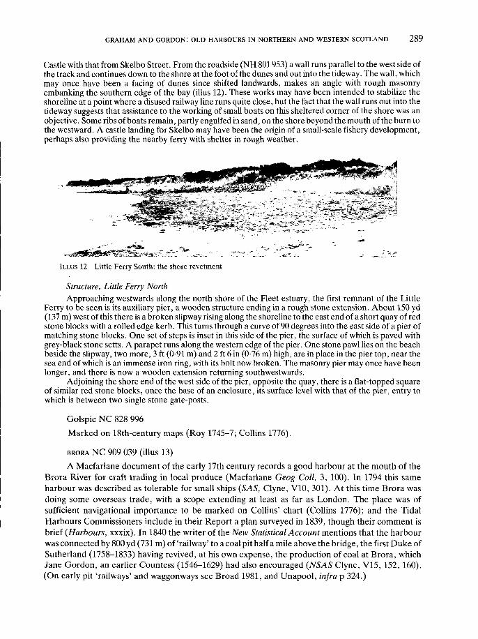
GRAHAM AND GORDON: OLD HARBOURS IN NORTHERN AND WESTERN SCOTLAND 289
Castle with that from Skelbo Street. From the roadside (NH 801 953) a wall runs parallel to the west side ofthe track and continues down to the shore at the foot of the dunes and out into the tideway. The wall, whichmay once have been a facing of dunes since shifted landwards, makes an angle with rough masonryembanking the southern edge of the bay (illus 12). These works may have been intended to stabilize theshoreline at a point where a disused railway line runs quite close, but the fact that the wall runs out into thetideway suggests that assistance to the working of small boats on this sheltered corner of the shore was anobjective. Some ribs of boats remain, partly engulfed in sand, on the shore beyond the mouth of the burn tothe westward. A castle landing for Skelbo may have been the origin of a small-scale fishery development,perhaps also providing the nearby ferry with shelter in rough weather.
ILLUS 12 Little Ferry South: the shore revetment
Structure, Little Ferry NorthApproaching westwards along the north shore of the Fleet estuary, the first remnant of the Little
Ferry to be seen is its auxiliary pier, a wooden structure ending in a rough stone extension. About 150 yd(137 m) west of this there is a broken slipway rising along the shoreline to the east end of a short quay of redstone blocks with a rolled edge kerb. This turns through a curve of 90 degrees into the east side of a pier ofmatching stone blocks. One set of steps is inset in this side of the pier, the surface of which is paved withgrey-black stone setts. A parapet runs along the western edge of the pier. One stone pawl lies on the beachbeside the slipway, two more, 3 ft (0-91 m) and 2 ft 6 in (0-76 m) high, are in place in the pier top, near thesea end of which is an immense iron ring, with its bolt now broken. The masonry pier may once have beenlonger, and there is now a wooden extension returning southwestwards.
Adjoining the shore end of the west side of the pier, opposite the quay, there is a flat-topped squareof similar red stone blocks, once the base of an enclosure, its surface level with that of the pier, entry towhich is between two single stone gate-posts.
Golspie NC 828 996Marked on 18th-century maps (Roy 1745-7; Collins 1776).
BRORA NC 909 039 (illus 13)A Macfarlane document of the early 17th century records a good harbour at the mouth of the
Brora River for craft trading in local produce (Macfarlane Geog Coll, 3, 100). In 1794 this sameharbour was described as tolerable for small ships (SAS, Clyne, V10, 301). At this time Brora wasdoing some overseas trade, with a scope extending at least as far as London. The place was ofsufficient navigational importance to be marked on Collins' chart (Collins 1776); and the TidalHarbours Commissioners include in their Report a plan surveyed in 1839, though their comment isbrief (Harbours, xxxix). In 1840 the writer of the New Statistical Account mentions that the harbourwas connected by 800 yd (731 m) of 'railway' to a coal pit half a mile above the bridge, the first Duke ofSutherland (1758-1833) having revived, at his own expense, the production of coal at Brora, whichJane Gordon, an earlier Countess (1546-1629) had also encouraged (NSAS Clyne, V15, 152, 160).(On early pit 'railways' and waggonways see Broad 1981, and Unapool, infra p 324.)

290 SOCIETY OF ANTIQUARIES OF SCOTLAND, 1987
StructureThe right bank of the river Brora below the town has been cut back to form one right angle between
the outer east-west shoreline and a short south-north section, and another where the east-west line of theright bank, at the narrows, is resumed. This modified section of the bank is faced with six courses of redstone blocks, slightly battered and neatly curved round the corners. The revetment of the bank iscontinued upstream, lining a U-shaped inlet, or small dock, in the right bank, parallel to the river channel.The dockside quay is faced with at least 10 courses of red stone blocks, not rounded at the edge except bywear. The only steps are at the middle of the top end (illus 13). From that point, the number of coursesdecreases gradually to two, where the facing runs out into a bank topped with vegetation. There are twowooden posts set in the surface of this bank, and five more on the left bank of the river.
ILLUS 13 Brora: the head of the coaling dock
Dunrobin NC 853 006The landing place for Dunrobin Castle. Marked on 18th-century maps (Roy 1745-7; Collins
1776). J Henderson's Additional Survey Report of 1811 (Henderson 1812b, 134) stated that 'waterfrom the burn of Golspie . . . is to scour the harbour where a new pier is now erecting, on the shorenear the garden of Dunrobin'. The accompanying plan shows that the length of the pier was 250 ft(76 m), the breadth 30 ft (9-1 m). A wooden frame, an unusual if not unique feature, supported astructure with slightly battered sides, a parapet and a rounded return head, projecting obliquely,south-westwards from the shoreline. Within the last 10 years this pier, or a successor, has beendestroyed by storms. Remains of the wooden framework and stone debris may be seen.
Loth NC 960 085Marked by Collins (1776). In 1793 there were several 'harbours', evidently natural inlets usable
by fishing craft (SAS, Loth, V6, 317). East-north-east of the mouth of the River Loth (which mayhave had its course rationalized, possibly even before the building of the coastal railway line), a lowlying area behind a line of sand dunes is now drained by ditches into the sea below Lothmore. JaneGordon, Countess of Sutherland (1546-1629), who resided after 1594 at Crakaig, the dower house ofDunrobin, beween Lothmore and Lothbeg and overlooking this area, is credited locally with havingdrained the loch or lochs, of which the name Loth is asserted to be a corrupt form. A prominent earlyimprover of estates, she could have used a landing place at Loth, if only to supply her establishment at

GRAHAM AND GORDON: OLD HARBOURS IN NORTHERN AND WESTERN SCOTLAND | 291
Crakaig, which is connected by a road on a causeway across the reclaimed area with the dunes andpromontory of Lothbeg Point.
Portgower ND 007 131A fishing village (NSAS, Loth, V15, 208)
Garty ND 014 137Marked by Collins (1776).
HELMSDALE ND 030 153
The mouth of the Helmsdale River was one of those listed in a Macfarlane document of theearly 17th century as good harbours for ships trading in local produce (Macfarlane Geog Coll, 3,100).Further evidence that it possessed a certain importance before improvement became general is givenby the fact of its inclusion on Collins's chart (Collins 1776) and earlier on Bishop Leslie's map of the1570s (Brown 1893,114). The earliest harbour works came only in 1818, with a pier and breastworkwhich were later enlarged and extended (NSAS Loth V15,209). Shipping from all parts of Britain andIreland were now (1841) making use of the port (ibid, 208). An important fishing station wasorganized, with further construction in 1840 (Harbours, xxxiv, plan app C 376); and what Groomedescribes as a new harbour was built in 1892 (Groome 1901, sv).
A map of 1833 from Dunrobin Castle (Burnett & Scott 1833) marks another pier to the north,between East Helmsdale and Navidale, near a distillery.
StructureThe present harbour is outside and immediately to the east of the mouth of the Helmsdale River. The
outer pier shows no obvious early features, but the sloping inner shore of the harbour is faced for a distanceof 200 yd (183 m) with rough pieces of red stone. Near the curved west corner courses of worn grey stoneblocks rise from the beach to an overhanging rolled edge kerb, much worn. There is an adjoining section ofbetter grey stone blocks rising to a less worn rolled edge kerb, from the end of which the modern pierprojects east-south-east.
From the west side of this pier the left bank of the river, here flowing from north-west to south-east,and spanned by a modern road bridge, is faced with red stone blocks. Below the bridge there is a sectionwhere the blocks are set with their longer sides horizontal. Red stone block construction of a more commonkind, the faces of the blocks nearly square and with their shorter sides set horizontally, lines the left bankfrom the bridge as far as the mouth of a rough dock about 160 yd (146 m) upstream from the harbour. Fourred stone pawls are set about 5 ft (1-5 m) back from the edge of the quay so formed. The head end of thedock for about half its length of approximately 50 yd (45-7 m) is lined on each side with rougher masonry,giving way to a narrow beach at the end. The rounded extremity of the outer arm of the dock is, however, ofmuch neater block work. In the centre of the rounded end there is a short flight of steps, leading down to alower, narrower ridge of stones with a convex surface. This groyne extends downstream nearly as far as thebridge. In it are set large timber posts, while smaller timbers lean towards them from bases in the river bed,close by on the left hand side. The right bank of the river opposite the dock is revetted with masonry. Thereare two lined recesses in this, but no quay, or even a path at the foot of the very steep bank.
Berriedale ND 121 225 (illus 14)Inland from the Ord of Caithness, Morvern (706 m) and the Scarabens are drained by the
Langwell and Berriedale Rivers into gorges which unite about 50 m from the sea. The course of thecombined river turns from south-south-east to north-north-east at its mouth, between a high fortifiedcliff above the right bank and a tongue of shingle on the left, which has been driven into the angle by

292 | SOCIETY OF ANTIQUARIES OF SCOTLAND, 1987
the sea. The shingle bank now almost blocks the exit. These natural hazards no doubt help to explainwhy herring fishing from Berriedale was discontinued before 1840 (NSAS, Latheron, V15, 104),though salmon were still 'kitted' and sent to the London market. (On export of salmon, see DNB, 14,335 on George Dempster of Dunnichen.)
StructureAny boat in the deep poolatthefootof the cliff would be well sheltered, and could be reached from
the left bank. For access from the right bank, there is a very small beach of stones at the base of the cliff,which may conceivably have been of some use to the castle directly above (illus 14). Upstream from this,the right bank has been faced, kerbed and paved with stone blocks to form a quay about 50 yd (45-7 m)long. Three yards (2-7 m) from the rectangular downstream end of this quay, a flight of stone stairs 1 ft 9 in(0-53 m) wide is inset. About 20 yd (18-3 m) from its upstream end, the south-westerly line of the quaychanges, rounding a corner where perhaps it once ended, and straightening again for the final 30 yd(27-4 m) on a slightly more southerly line. The straight sides of the great fan-shaped capstone of the cornerare 4 ft (1-2 m) long. One of its iron cramps is still in place, as are four others in the kerb nearby. The bankbehind the quay is roughly faced with stone in a few places.
About 8 yd (7-3 m) upstream from the quay, a suspension bridge gives access to the left bank andbeach to the north. The bridge rests on stone slab abutments without mortar. A row of four old cottagesbuilt of stone slabs faces out to sea from a terrace above the north end of the shingle beach, before it meetsthe next rocky headland. The terrace is fronted by a sea wall 30 yd (27-4 m) long of small red and grey stoneslabs. These are set vertically up to one lateral top course and finished with a row of rounded stones. Thereis much slab debris at the foot of the wall, possibly the remains of an improved 'spending beach', of which aheavy kerb set into the south end of this beach may also be a remnant. Two more old houses, and an ice-
ILLUS 14 Berriedale: the quay and shingle bank (far left) blocking the entrance to the harbour

GRAHAM AND GORDON: OLD HARBOURS IN NORTHERN AND WESTERN SCOTLAND 293
house built into the bank above the beach are evidence of earlier determination to use this harbour, in spiteof its obvious dangers.
DUNBEATH ND 166 293 (illus 15)This place was of sufficient importance in the 1570s to be marked on Bishop Leslie's map
(Brown 1893,114). A Macf arlane document probably of the 1720s, records that small barks anchoredin the mouth of Dunbeath Water, and that this was the port most frequently visited by boats,presumably fishing boats, from Moray (Macfarlane Geog Coll, 1, 164). In 1840 the place wasregarded as suitable for development (NSAS, Latheron, V15,106); and in 1847 the Tidal HarboursCommissioners described Dunbeath as a fishing station and noted that the local fishermen had built asea wall there (Harbours, xxxix).
StructurePortormin Head is a bluff on the right at the entry to Dunbeath Bay from the east. The Dunbeath
Water flows out into the north-west corner of the bay. At the foot of the bluff a rock pocket and a smallsandy bay lie sheltered from the east and north, constituting, perhaps the original 'port'. The modern pierprojects south-westwards into the main opening of Dunbeath Bay about half way from the bluff to thenarrows at the river mouth. An older looking slip rises from the beach to the shore end of the modern pier,at right angles to its outer side. From the beach on the inner side of the shore end of the modern pier,another slip rises at right angles to the pier up to the surface level of a modern quay. This follows the curveof the river bank at the narrows, and adjoins a ruinous section, faced with red stone blocks, probably theremains of the 1847 sea wall. Very steep steps are inset at each end of this face, which ends quite near the
ILLUS 15 Dunbeath: the 1847 sea wall and two flights of very steep steps. Stones salvaged from the recently collapsedface at upper right

294 SOCIETY OF ANTIQUARIES OF SCOTLAND, 1987
point at which a wooden jetty projects into the river (illus 15). One rough stone pawl 2 ft (0-6 m) highstands at the back of the quay in line with the head of the jetty. On the right bank of the river, a little nearerthe mouth than the left bank jetty, the framework of another wooden jetty survives, suggesting a ferrycrossing earlier than, or supplementary to the road bridge which crosses further upstream.
Latheronwheel ND 191 321 (illus 16)The British Fisheries Society in 1817 included Latheronwheel and four other small places in the
fishing station of Lybster. Swany's plan of 1840 (RHP 4250), shows, however, that the inlet, a goewith rocks and one stack 40 ft (12-1 m) high in its mouth, had acquired few harbour facilities in theintervening 23 years (illus 16). The plan shows a rough quay along the north shore, and masonryblocking the 12 ft (3-6 m) gap between the stack and the shore. Both these structures correspond toregular features of the later harbour. It is not clear from the plan whether Swany recorded existingworks or marked either or both as proposals. Stevenson's plan, dated 20 October 1851 (in the WestRegister House, Edinburgh), shows the south gap breakwater breached. From the quay along thenorth shore, a pier projects into the inlet and is marked 'Old Pier'. This appears to have beenconstructed between 1840 and 1850 on the foundation of a natural rock outcrop at the east end of thenorth quay, and may be the 'fishery harbour' which Mitchell (1883, V2,130) states that he built herefor the proprietor, the Hon Robert Dunbar.
StructureThe form of the early 19th-century harbour of Latheronwheel is more readily understood from the
OS 1:2500 map of 1906, than by reference either to Stevenson's plan or to the harbour as it is today. Not allof Stevenson's plan was realized, and there have been many more modern changes. In 1906, the pier of the1840s had been somewhat extended, but the curve of the bay head was not much changed, except for asmall projection along the left side of the burn mouth, where the outfall appears to have been canalized.The south gap breakwater is in place.
LYBSTER ND 245 350 (illus 17)In 1817 the British Fisheries Society organized Lybster fishing station, working 40 boats and
including Forse, Achastle, Swiney and Clyth. By 1833 this station was the third largest in all Scotland(Mowat 1938). W G Mowat, the local historian whose account is followed throughout this note,adduces place name evidence for early Christian and Viking use of the landing place at the mouth ofthe Reisgill Burn in Lybster bay, and leads up to its development at the height of the herring fishingboom by recording that clearance victims were fishing here for lobsters in 1793. The improvingproprietor, General Patrick Sinclair of Lybster founded the village in 1802 and began to grow wheatin 1806. He built a timber pier in 1810. In 1830 the harbour was formed by the erection of a stone pier90 yd (82-2 m) long, paid for wholly by the proprietor, Captain T F Sinclair. Mowat dates thecompletion of this pier in 1832, and states that it ran south along the west bank of the Reisgill to thesea, and that a stone jetty with an adjoining retaining wall and an upper retaining wall was built on theeast side of the harbour mouth in the same year. Boats at this time were beached or moored to rings inthe rocks near the Reisgill waterfall. In 1833 Inver House, then an inn, was built into the face of thehillside above the right bank of the burn, which was diverted from crossing the building site into itspresent course. This is as already shown on the Admiralty Survey made by Slater and Calver in 1839.Their plan, published by the Tidal Harbours Commissioners in 1847 (Harbours, App C, 376) showsan area of the burn mouth inside both piers largely dried out at low tide, and illustrates the need fordeepening alluded to in the New Statistical Account (V15, 105). After a gale in 1848, in which 94Caithness fishermen were drowned, the Washington Commission (Washington 1848, 272) issued apreliminary extract from the main Report (Washington 1849) recommending improvement of the

GRAHAM AND GORDON! OLD HARBOURS IN NORTHERN AND WESTERN SCOTLAND I 295
T H E H A R B O U R O F L A T H E R O N W H E E L
( f r o m a copy of the plan of 1 8 4 0 )
ILLUS 16 Latheronwheel: from P Swany's optimistic plan, 1840

296 | SOCIETY OF ANTIQUARIES OF SCOTLAND, 1987
BOATS (SCOTLAND)
Km,,, |Ji<- Ailmir.-ijly Survey
: SI,ATfiK * M" R. K.CALYRH. K.N
iX Till.:. ri«r.l()Kc!Cl Neap* U, 8 KiaiL.
XcJiint ranjjc ti Vcr.t,.
N'101. Oiilnivd.lr The House of Commnn«.tu be riinu-.l, l̂ JiIgri-.li 184..1.
ILLUS 17 Lybster: J Mitchell's plan of the harbour built on the 1848 recommendation of theWashington Commission

GRAHAM AND GORDON: OLD HARBOURS IN NORTHERN AND WESTERN SCOTLAND 297
'small but safe harbour of Lybster' with an urgency in strong contrast to the tone of the recommenda-tions for Wick which emerged after a long enquiry. Work financed by the resulting Parliamentarygrant enabled Lybster to shelter 100 boats. J Mitchell, the Fishery Commissioners' engineer,supervised work by a Perth contractor to the designs of D Stephenson (illus 17). Improvementscontinued after 1850, causing riots when construction stopped fishing, and left the harbour much as itis today, apart from internal north and east jetties. The weir in the Reisgill, specifically recommendedby Washington, was made at this time.
StructureThe site of General Sinclair's wooden pier of 1810 is perhaps most likely to have been the same as
that of the stone jetty of 1832 on the east bank, as this is sheltered from the north and east and would,before the long west bank extension pier was run out to below low water mark opposite, have been directlyat the burn mouth. The lozenge-shaped head of the pier now occupying this site is built of large roughblocks, in the surface of which one stone pawl survives. A slip rises behind rocks to the south-east up to thelevel of the former fish-curing buildings. The form of the retaining walls running inland along the left bankshows little change from the plan of 1839 in spite of modern resurfacing and additions. Four sets of steps inthe shore wall, and three in the land-retaining wall recall the heightened activity of transferring herringfrom a harbour full of boats to the curing stations above, between tides. The shoreward end and west side ofthe harbour show fewer early features. There is still a slip in the centre of the shoreward end. This served aboatyard which replaced the curing ground shown there in 1839. The enlarged basin of the 1850s brought anew approach road to the back of its new quays, adjoining the improved and straightened 90 yd (82-2 m)pier, which still occupies the site of the 1832 original.
Clyth ND 280 358In 1840 a fishing village with a 'neat little pier' (NSAS, V15, 105) was part of Lybster fishing
station. The OS 1:2500 map of 1906 shows a short straight pier projecting from the north shore of thenarrow inlet marked Clyth Harbour. A plan in the West Register House, Edinburgh, dated 1893(RHP 4294), is of a short pier at this point, from which a path is marked, leading to two buildings atthe head of the inlet.
Occumster ND 265 353A small burn runs out of a v-shaped fissure directly on to the beach of an inlet with very steep
sides, sheltered from the north and east. A fish house stands just above high water mark on the beachto the west of the burn mouth. Of the pier built partly by Bremner before 1845, according to Mowat(1980, 10), and marked on the 1871 OS 1:2500 map, only a short stretch, consisting of long narrowflagstones vertically laid, survives at the foot of the cliff to the north of the inlet. Partial shelter fromthe south is given here by a stack off shore, south-west of Creek Belly. The track from Occumsterdescends through a double hairpin bend to the steep rock incline above Creek Belly, to which it wascarried down a slope on a facing of masonry, which survives. It did not reach the sea, and boats couldonly have been loaded and unloaded in Creek Belly by haulage over the rocks. There is no visible pathto the inner harbour, and it seems most likely that the pier and fish house were reached only by boat.
Whaligoe ND 321 403 (illus 2, 18, 19)Pennant, in 1769 (1979,333) noted the 365 steps in the face of the 360 ft (109-4 m) cliff, up which
fish were carried from boats using the inlet (illus 2, 18).The 365 steps still give access to the north shore of the inlet, and to the remains of a stonebuilt
quay, approximately 30 yd (27-4 m) long and 11 yd (10 m) wide. With their low balustrade, formed,like the steps themselves, of Caithness flagstones, the steps have been partially repaired at intervalsup to the present. Many are broken, and parts of the structure are in some danger from landslips. Five

298 | SOCIETY OF ANTIQUARIES OF SCOTLAND, 1987
s t r u c t u r e present (8 4 87)
( rev ised 1905)_ . _ . _ . m a r k e d on O.S.25" 1868
.............. mean high spring f ide
I .LlU>l. l j foo t o f c l i f f
• wooden paw
n w i n c h
W H A L I G O E S T E P S
ILLUS 18 Whaligoe: plan of steps and harbour
«*,'.'•?'.*?,^v.^^pS
«.4*w Tffi&SfcL V* *i* ,' -.• •._ .̂'-/--,& :/•!••> --siy*£>
ILLUS 19 Whaligoe: the second and third turnings of thesteps, looking down and across to the cliff on thesouth side of the goe

GRAHAM AND GORDON: OLD HARBOURS IN NORTHERN AND WESTERN SCOTLAND | 299
hairpin bends take advantage of natural inequalities in the cliff face (illus 19). Twenty-one more stepslead down from the main quay, on which stands the ruin of the harbour house, to what is now openshore near the head of the inlet (illus 18). At least as late as 1905, there was a third flight of smallersteps, nearer still to the head of the inlet, and descending to the tide line. The OS maps of 1868,1871and 1905, though far from clear, seem to indicate that there was, for some time, structure at a lowerlevel than that of the surviving quay. Levelling of the shore between this quay and the head of the inletwould have had obvious advantages, and may perhaps have been the first of the improvements tohave been achieved, possibly even at the same time as the main steps were built. Even more difficultto interpret is the mapping of the area, now also reverted to open shore, below the long face of themain quay. None of the early maps distinguishs clearly between the line marking mean high watersprings, and that denoting structural improvement of the shore line along this stretch, but the angularshape indicated at the tip of this area appears to contrast strongly with the natural conformation of theneighbouring shore lines. It may be that an originally natural or slightly improved rock slip along thisface of the main quay was at one time paved. The main flight of steps is the only structure which wascertainly built before 1850. The surviving 20 ft (6 m) high warping post, the base of which hascompletely disappeared from the rocks in which it is set, and the iron rings, one in the sea-face of theharbour house, and at least three more in offshore rocks, may be early features or successors of such,since it must always have been exceedingly difficult to obtain safe passage into the inlet. The remainsof two winches, probably of much later date, one at the head of the inlet and one at the foot of thesteps, witness to the same struggles. The two niches and the open chimney in the supporting wall ofthe lowest flight of the main steps may have been used for lights. One feature of the main quay,suggesting that parts of it, at least, are later than the steps, is the iron basin set in the broken endnearest the open sea. Part of an iron ladder may be seen projecting from the stonework beneath thebasin. The steps themselves are as impressive a structure as any harbour work of the 18th or early 19thcentury in Scotland. The achievement of building them illustrates the strength of the contemporaryneed to work the fishery of this coast, and a large house, Whaligoe Square, near the head of the stepsshows that wealth did accrue, to some. The place-name has an early Christian origin (Holy goe), butwhales' jawbones are set up locally and this latter association has overlaid the former.
SARCLET ND 352 433 (illus 20, 21)An early mention of Sarclet harbour occurs in the papers of James Sinclair in Sarclet (otherwise
Thrumster), who died in 1816 (Sinclair 1802), together with the information that there were also saltpans at Sarclet. Local availability of salt may be one reason why this 'goe', a narrow U-shaped inlet inthe cliffs, was considered so promising as a fishery harbour that efforts were made from the beginningof the 19th century to protect boats calling there, in spite of its restricted entrance, and rocks in thefairway.
Sarclet village and Thrumster House were built by David Brodie of Hopeville, a son-in-law andtenant of the Sinclair proprietor (Mitchison 1962,192), and the harbour is known today as Brodie'sHaven, on account of his efforts to build a breakwater at the entrance, before the estate reverted to aSinclair proprietor in 1817. Brodie spent £950 on the operation, which soon failed (Henderson1812a).
The next proprietor of Thrumster was James Innes, whose son Robert was one of the first threeproprietors in Scotland to obtain a Treasury grant for harbour building by contributing a proportionof the cost of works surveyed, estimated and organized by the Fisheries Commissioners as describedin their Report for the year ended 5 April 1829 (Reports Commissioners 1830, 5, 15 & 21). Early in1828, the Commissioners having secured Treasury agreement under the Act (48 Geo 111 c 110 s 7 andc 94 s 4), appointed J Mitchell to the post of engineer. His plans for Sarclet, Rockfield and Hilton of

300 | SOCIETY OF ANTIQUARIES OF SCOTLAND, 1987
PLAN &• SECTIONol'a .
IN TJJK COUNTY Of Cas certified by
JOSEPH MITC1IKLL .
1828.
ILLUS 20 Sarclet: J Mitchell's plans illustrating the increase in complexity of theharbour project from 1828 to 1843, Herring Fisheries Commission, 1830V15, 182-3
Cadboll are included in the 1830 Report. Correspondence between the Commission's Secretary andRobert Innes (kindly made available by Mrs I Macleod), reveals details of the negotiations, and of thework of building with its many setbacks and difficulties, up to 1844. Even then, though the Commis-sioners regarded the work as complete, Robert Innes remained highly dissatisfied. He had spent farmore than his initial contribution of one-third of the cost, estimated by Mitchell at £1106 13s 4d, andhad seen the destruction of the work by storms in 1831 and 1833. James Bremner claimed to have

GRAHAM AND GORDON: OLD HARBOURS IN NORTHERN AND WESTERN SCOTLAND 301
ILLUS 21 Sarclet; from Herring Fisheries Commission, 1846 V23, 20-1
302 | SOCIETY OF ANTIQUARIES OF SCOTLAND, 1987
rebuilt Sarclet harbour between 1834 and 1841 (Bremner 1845, 23-5 & app 5, 47). His biographer(Mowat 1980,9,10) describes his use of barges to bring stones from Wick and lay them directly fromthese transports onto the sea bed, and, in the final stages, of cranes with jibs extending 120 ft (36-5 m)out over the cliff top. Some of the cranes used, though probably not these innovatory types, belongedto Robert Innes, whose letters reveal bad relations with Bremner about this and the delays in thework. The breakwater and other improvements are shown in detail on a plan (kindly made availableby Mrs I Macleod), drawn by Mitchell in 1843. A feature of interest is the powerful capstan sited at thehead of the inlet, beyond the fish curing ground, essential for manoeuvring boats in the narrow creek,and into the minute harbour with its 35 ft (10-6 m) entrance. This plan differs substantially from theone Mitchell made in 1828, which shows no capstan, no pier on the north side of the entrance and nosloped pitching either on the sea face of the main pier or on the beach at the head of the harbour basin.The New Statistical Account (NSAS15,157) records that by 1841 the cove had been converted at greatexpense, into a 'pretty good harbour for fishing boats'. Not until 1845, however, could Mitchell reportto the Fishery Commissioners that the harbour, with additions specified in 1842 and costing£569 Os 9d, of which a quarter was paid by Robert Innes, was complete. The Harbour Commissionersin 1847 considered Sarclet one of the best fishing stations, though the harbour was 'very uneasy' dueto the lack of a spending beach, and with room for only 33 boats in its half acre of sheltered water(Harbours, xl).
StructureThe remains of a breakwater across the mouth of the inlet are clearly visible, and are presumably
those of the structure designed by Mitchell and erected, before 1844, by Bremner, which fell in 1880. Thefacing of the head of the inlet with grey stone and its paved shore are probably of similar date. The remainsof the great capstan, or possibly a successor to that of 1843 can be seen. The harbour is approached by avery steep track rounding the head of the inlet from the north and descending to what may be a natural orpartially rock-cut quay at the foot of the cliff to the south.
WICK ND 370 506 (at entrance to harbour of 1831) (illus 22-4)The old part of the town of Wick stands on the left bank of the river of the same name, close to
its mouth and well within the tidal range. Bishop Leslie, writing in the 1570s, describes Wick as thechief town of Caithness (Brown 1893,142) but makes no mention of a harbour. Although the Bay ofWick is the first opening in the coastline to the south of Duncansby Head to receive the outfall of ariver of any considerable size, harbour development there has always been difficult. Shelter from theeast is lacking, and it is from that quarter that some of the worst storms blow. Even today, noextensive area of the bay can be enclosed behind heavy protective works, because the sea bed is ofclay, in which foundations tend to shift. (Information by courtesy of Mr A Barry, Scottish Develop-ment Department.) Sand from the sea and silt from the river choke the head of the bay so that thebetter sheltered areas require constant dredging. On Bishop Leslie's map (Brown 1893, 114) a longnarrow inlet of the sea is shown in place of the stretch of river above the town, and this strikes inlandalong a line corresponding with the strip of low-lying and partially mossy ground that extends almostto Loch Watten. Shipping in the late 16th century used the town's waterfront, whether this was simplya beach or some kind of wharfage. In 1589 the Royal Burgh of Wick had a charter of King James VI,after Sutherland's men had plundered the possessions of a merchant, including his ships (Calder 1887,33-5). At least one ship was seriously damaged (NSAS V15,155). A Macfarlane document, datableto the early 17th century, (Macfarlane Geog Coll, 2,243) describes Wick as a safe harbour for ships tocall at (oppidum . . . portu appellandis navibus tutum) while another mentions it as a harbour for thecoasting trade in imports and exports (ibid 3, 84). In 1654, however, the Cromwellian Commissioner

GRAHAM AND GORDON: OLD HARBOURS IN NORTHERN AND WESTERN SCOTLAND 303
Tucker reported no vessel belonging to Wick (Calder 1887,33-5). By 1701 the description of Wick bythe Reverend John Brand shows that a revival had begun (Brand 1883, 226):
Wick is a Royal Burgh . . . by the side of which runneth a small river, at the mouth of the River is aharbour for Boats or Barks to ly in, which they come in at full sea, but this harbour is not so muchfrequented as another, about a Mile to the North East of Wick, where they judge the boats do lysafer.
Sutherland relates this development to legislative changes beginning with the Act of 1661(Sutherland 1982,18) the first to encourage the setting up of a company to establish fishing stations.Sutherland further relates harbour development at Wick to the associated change from the use oflarge ships, 'herring busses', to much smaller craft. Legislation provided in 1750 for a bounty onherring fishing boats of 20 to 80 tons, and in 1756 for the free use by fishermen of any suitable harbouror shore. Staxigoe, the inlet north of Wick where Brand heard that ships could 'ly safer', adjoins thefarm of Field, from where, in 1757, Alexander Miller with two partners fitted out two sloops on thebounty and began to fish, Wick having then no harbour 'only a rough quay, as most of the small tradeit had was taken over the sandy shores of its river' (Sutherland 1982, 21). Miller and his neighboursprospered. The first local station of the British Fisheries Society, incorporated in 1786, was atStaxigoe, the owners of smaller boats participating in greatly increasing numbers after 1785 whenbounty was made payable on herring caught. Bounty was paid on 32 sloops in 1790 when 200 smallboats worked out of Staxigoe, Wick, and Broadhaven which is a rather less snug inlet between thetwo. Of the 230, 44 vessels wintered in the 'ship pool' at Wick (PCFC 1869). In 1793 J Rennieapproved a plan, attributed in the Report of the Washington Commission on gale damage in 1849 toJ Henderson, made a survey and estimated for the British Fisheries Society that to build a harbour atWick would cost £14 441 9s. Henderson had planned a harbour in the natural bed of the river near thetown to be excavated to the level of low water at spring tide and to have a canal leading to it on thewest (ie the right bank) side of the estuary. By 1801, however, when the Society sent T Telford toacquire a harbour site, the 'natural harbour' area was required for the development of the Society'ssettlement (Washington 1849, viii), and the harbour was sited, perhaps more economically, in thenorth-west corner of the bay (illus 22). The first, inner or north harbour was planned and laid out byTelford in 1803 (Bremner 1845, 7). The society obtained a grant of £7500 under the Fisheries Act of1806 and the foundation stone was laid on 6 September in that year. The grant accrued from the workof the Commissioners for the Forfeited Estates (Dunlop 1952,49). Half the initial cost of the harbourwas in this way derived from one of the major operations which changed land ownership andmanagement in the Highlands at this time and caused many people to seek work especially in coastalareas including Wick. The harbour was not completed until 1811. Feus on the right bank of the riverhad been acquired from the estate of Hempbriggs, to which Alexander Miller was factor. Telforddesigned the new settlement for the fishing community, named Pulteney Town after the chairman ofthe society. The resident population of Lower Pulteney Town grew from 15 in 1790 to 2300 in 1830,and there was also a very large seasonal increase. Piped water, however, did not reach the harbourarea until 1844. The resulting epidemic cholera merely checked further expansion periodically(Sutherland 1982, 30).
This expansion necessitated the provision of an outer harbour, planned in 1824, surveyed byMitchell in 1825, partially destroyed by a storm while under construction by Bremner in 1827, andcompleted, together with modifications of the inner harbour including the closing of its originalentrance and the opening of another into the new harbour, in 1831. The Secretary to the BritishFisheries Society gave 1834 as the date of final completion in his report (BFS 1848). In 1842 Gibb, theAberdeen engineer, was being consulted about sand accumulating in that harbour. The recommen-

304 | SOCIETY OF ANTIQUARIES OF SCOTLAND, 1987
' < .-'"""" \ BJUT/SK .fo>.'jt-:T>'''#r* P****" ." rurf&tMr •'/
•V 1^-~ * 1 O S ,)tfjH**''"' '' .
!$* J«\_ ,»,-,«w ' .t"«.v./.'/>r.v, ,</'
HKMl-KIIfii'-.
ILLUS 22 Wick: J Henderson's plan, 1812, from his General Survey of the Agriculture of Caithness. Here,his recommendation of a harbour in the natural bed of the river has given way to the Rennie-Telford-Bremner scheme of harbours on the south shore of the estuary. But Henderson isvague as to their shape, and has retained a vestigial section of canal
dation was then that Salmon Rock, further out along the same shore of the bay, would be a suitablesite for a steamer pier. A proposed harbour between Salmon Rock and the east pier of the outerharbour is marked on the 1839 Admiralty Survey plan published by the Tidal Harbours Commis-sioners in 1847 (Harbours, App C, 376). Instead, the outer and inner harbours were deepened in 1847and 1848. From then until the terminal date of this study in 1850, the harbour facilities at Wick were

GRAHAM AND GORDON: OLD HARBOURS IN NORTHERN AND WESTERN SCOTLAND 305
W I C K & PrLTK.VEY TOWS,From UM- Admiralty Ssnrv
BV'COJUI* St&TKR t M* K.K. CAI.VER.S Sl»3»
flli* Cmtrtifnf of tr Ikf firrfntt rlftf
SG*L£ Of F££T
ILLUS 23 Wick: plan accompanying the Washington Report, 1849, in which the rivet was still acknowledged to offer themost sheltered refuge, but Pulteneytown had encroached upon the only possible site in its bed
continually overcrowded, and their deficiencies felt. In particular, the inadequacy of Wick as aharbour of refuge, with its narrow, north facing entrance at right angles to the river mouth, led to theloss of 37 lives in sight of the harbour, in a storm in 1848 (illus 23). The Salmon Rock proposal wastherefore reconsidered. In view of the failure of Stephenson's later massive breakwater, the societywas probably right in rejecting the scheme on the advice of their Secretary and Law Agents in 1848(Mitchell 1883, 304-6).
Small harbour works along the north shore of the bay are shown on the OS 1:2500 map of 1903,having grown in response to the overcrowding of the 1811 and 1831 harbours. Though none of thelater 19th century attempts to render Wick safe as a harbour of refuge succeeded, its vast trade inherring declined only recently.
A fortnightly steamer began to ply to Leith in 1833, and later a weekly one ran to Lerwick,Kirkwall, Aberdeen and again Leith. Sand in the harbour interrupted steamer services in 1860, nodoubt with adverse effects on the traffic in freight, which in 1841 amounted to 30,000 tons (A'SVl.SV15, 152).
StructureThe harbour area of Wick lies in a narrow cleft between the old town on the left bank of the river and
a steep slope up from the right bank to the high ground from which upper Pulteneytown overlooks theestuary. The location of the 'ship-pool of Wick', in use in 1791, has not been identified. A plan of the townin Henderson's General View of the Agricultural of Caithness, printed in 1812, differs from the plan of 1789,referred to in the Washington Report, in many ways including the lack of an exit, with piers and sluices, for

306 SOCIETY OF ANTIQUARIES OF SCOTLAND, 1987
the proposed canal. On a stretch of the river below the (A9) road-bridge are the words'. . .vessels. . .liein this part of the river'. It is not a pool, but above the bridge and the next bend in the river there is a widerstretch which might be so described. This is marked 'THE RIVER OF WICK' and was crossed by a timberbridge. An oil painting of the period shows boats beached on the left bank where the river narrows, belowan area still known as the Drying Green. (Information by courtesy of Mrs I Macleod.)
The layout of the harbours as completed in 1831 is little changed today, though largely covered in bymodern surfacing. The entrance to the outer harbour consists of an opening between the tip of abreakwater running out north-eastwards into the bay, and a pier, the north pier, which extends north-westwards along the edge of the tideway on the right hand side of the estuary to join the river bank justbelow a bridge which now spans the mouth. At the entrance to the 1831 harbour the breakwater pieroriginally extended well out into the tideway beyond the opening. A further extension was added in 1883.The 1831 harbour had originally a paved slope along its south-west side (Harbours, 1847 App C, 376). Awharf was built out over this before 1920 (Sutherland 1982, 71). The present entrance to the inner, 1811,harbour is an opening between its north pier and the eastern arm of the outer harbour. Slabs of grey stone,laid laterally, are visible from about half way along the inner face of the 1811 north pier to its eastern tip,which could be those laid in place by Bremner when he closed the original entrance and built the outerharbour. A slight change in the alignment of the north pier inner face before it reaches the opening of theouter harbour suggests that the original opening of the outer harbour may have been at about this point.Vertically laid flagstones, which Bremner used in so much harbour construction (Bremner 1845, 20) arestill readily visible only on the outer face of the 1834 harbour's east breakwater pier (illus 24).
The very recent construction of the north and south river piers and works along the left bank of theestuary have completely altered the river mouth, now a river basin, and the north shore frontage. A modelof the estuary prior to these works is in the Wick Society's museum, and shows the names of some of the oldsmall landing places, such as Reid's Harbour, and a projection called the Dicky.
ILLUS 24 Wick: vertical flagstones laid by 3 Bremner in the sea wall of the outer harbour in 1831. Photographed fromnear the Town's memorial to Bremner (1856), as one of its greatest benefactors

GRAHAM AND GORDON: OLD HARBOURS IN NORTHERN AND WESTERN SCOTLAND | 307
Broadhaven ND 380 513Described in 1794 as a 'fine bason' where herring boats were laid up in off season, and classed
with other coastal creeks (SAS, V10, 5). A fishing station in 1841 (NSAS, V15, 157).
STAXIGOE ND 386 525Although essentially a fishing station, incorportated in 1786 before the British Fisheries Society
began to develop Wick, Staxigoe must be credited with an even earlier history as a port. The NewStatistical Account (V15,157) recorded in 1841 two storehouses built in 1600; and at a date probablyearly in the 17th century it was described as a harbour for vessels engaged in the coasting trade(Macfarlane Geog Coll 3, 84). In 1794 it was noted as a creek to which ships could resort in summerbut where they could not lie safely in winter, and as a 'kind of port' for the export of local produce(SAS V10,5). Another note of 1841 classed it as a tolerably good harbour for boats (NSASV15,157).The Report of the Tidal Harbours Commission, 1847, appears to confuse it with Broadhaven, listedabove. Harbour works were carried out at Staxigoe, whereas Papigoe and Broadhaven, thoughnearer to the town of Wick, were less developed. One reason for this may have been that AlexanderMiller, who was the first to succeed at the herring fishing with small, four-man, eight-net boats, livedat the farm of Field, adjacent to Staxigoe.
StructureBoth sides of the creek or goe are revetted with vertically set flagstones. The stack, for which the
place is named, is a jagged rock pillar, rising to a height of about 25 ft (7-6 m) from the shore of the goe,above low water mark on the west side. The lower part of the stack is scored round with the wear ofmooring ropes and chains. Beside and below the stack, and nearer the middle of the harbour, the tops ofvertically set flagstones form rough steps in the course of their incline to seaward. These steps are carriedon by ridges which may have been cut, or perhaps merely improved by cutting, in the surface of the naturalrock incline below. The natural rock sides of the goe show signs of having been artificially smoothed, andthe tops of several rocks bear rings, still in use for lines and chains. Two rough stone pawls are in place onthe east side. At the centre of the high bank across the head of the harbour stands a wooden post 15 ft(4-5 m) high and 9 in (23 cm) in diameter. This seems more likely to have carried a light than to have been amooring post. It may not be in its original position as the harbour has recently been cleared of much originalconstruction.
Ackergill ND 349 545Described by the Tidal Harbours Commissioners in 1847 as a valuable landing place (Harbours,
xl), where a pier would be useful. Bremner had planned, surveyed and estimated the cost of a harbourhere before 1845 (Bremner 1845, 32). The OS 1:2500 map of 1964 marks a jetty and slipway, also aramp in Castle Haven to the west.
Keiss ND 351 609The New Statistical Account (NSAS 15, 158) states that a harbour was built here in 1810, but
Bremner gives 1818 as the date of his employment by the proprietor to build a harbour on the northside of Sinclair's Bay (Bremner 1845,12). Bremner, born in 1784 at Stain, the southernmost house inKeiss, began the work using barges and cranes like those he had already adapted to move large stoneblocks in the building of Wick Harbour. Keiss was the place where Bremner, according to hisbiographer (Mowat 1980, 4-5) first used vertically set flagstones, in accordance with his theory thatstones with their narrower faces presented to the sea would not readily be lifted by wave action(Bremner 1845, 12). The work was interrupted by the illness and financial difficulties of theproprietor, but Bremner's unfinished structure remained intact from 1821 to 1833, when a govern-

308 | SOCIETY OF ANTIQUARIES OF SCOTLAND, 1987
ment grant was obtained by the Trustees of the Keiss estate, and the work was completed (Harbours,xli).
StructureImmediately south of Tang Head, where the coastline turns west and then south, forming the
northern horn of Sinclair's Bay, a slightly curved pier with a short return head projects southwards for 200ft (60-8 m). Vertically set flagstones form the outer side of this eastern pier, rising to a parapet wall, theinner side of which is of red stone blocks. The pier protected by this heavy backing is itself built of verticalflagstones, fitted at their base on to natural rock, which continues beyond the end of the pier. Two roughstone pawls are in place near the sea end, and one half way along the pier. Two sets of steps are inset in thecurved inner face, the further one from land descending, and the nearer one ascending shore wards. Thereis a slip descending at right angles from the inner shore end of the east pier. A quay of vertical flagstones,150 ft (45-6 m) long, forms the shore embankment of the outer harbour, sheltered by the east pier. Thequay curves at its south end where a short straight pier projects towards the return head of the curvedwestern arm of the harbour. The short pier, also founded on natural rock, is of red stone blocks, paved withlaterally set flagstones, and is lower than the adjoining quay, up to which it inclines. Beyond the short pier,the quay runs straight for 150 ft (45-6 m) before meeting, at an acute angle, the western arm of the harbourwhich curves round to protect the inner basin. This western pier has five sets of steps in its inner face, noneof which reaches the base. Red stone blocks have been used for the construction of this inner side, and thatof its parapet wall, but there is again a heavy backing of vertical flagstones. The head of the west pierreturns at an acute angle to form a short pier, nearly in line with, and higher than, the short pier projectingfrom the shore quay opposite. Between these two is the entrance, no more than 30 ft (9-1 m) wide, to theinner basin. From the return head, there is a flight of steps up to the top of the parapet wall. Once inside thisharbour, there is some shelter from all quarters, and many flights of steps to assist working in all weathers.
Freswick Bay ND 379 671Mentioned in 1847 as a good anchorage in offshore winds (Harbours, xli). The shore of
Freswick Bay is sandy, and the mouth of its river unsuitable for the working of boats. Nevertheless,Freswick House stands at the river mouth, which appears to have been modified for workingpurposes, possibly in connection with a mill. Flat rocks beyond the sands make the shore largelyinaccessible. Across the Bay to the north there is, however, a small harbour at Skirza.
Skirza ND 387 680Nearly halfway along the north side of Freswick Bay from Skirza Head, a small stone pier 150 ft
(45-6 m) long and 20 ft (6 m) wide projects southwards, sheltering an inlet in the rocks of the shore. Aroad from Skirza House makes a right angled turn towards the head of this pier, which is approacheddown an incline roughly paved with worn stones. Very roughly stepped flagstones rise from thefurther side of the pier head to the front of a platform, the foundation of a small pier house. The innerface of the first 20 ft (6 m) section ofthepierisof worn lateral flagstones with rounded edges. Steps areinset in the sea end of this section, descending seawards. Beyond the steps, the inner face of the pier isof neater flagstones, also laid laterally, rising to a modern kerb edge. Another flight of steps descendsseawards near the sea end. The surface is paved with worn flagstones and a rough stone pawl is inplace near the rounded tip. The rounding has been achieved by setting vertical flagstones fan-wise.The parapet wall is modern, but is backed with rough flagstones, narrow faces outwards, set at anangle of about 45° to the sea bed.
The entrance to this small harbour is between the mid-section of the pier just described, and thehead of a modern pier extending towards it at right angles from the curved shore opposite. Thechannel, from the end of the modern pier outwards, is edged with large boulders, possibly debris fromthe wasting of the old pier, where this has been repaired and refaced. The gap in the rocks beyond theentrance to the artificial harbour is only 30 ft (9-1 m) wide at its mouth, but widens to 60 ft (18-2 m)

GRAHAM AND GORDON: OLD HARBOURS IN NORTHERN AND WESTERN SCOTLAND 309
where there is a D-shaped embrasure on its east side, about halfway to the pier head. This tiny alcoveis marked 'Haven of Skirza' on the 1968 OS 1:2500 map.
THE NORTH COAST: DUNCANSBY HEAD TO CAPE WRATH (illus 25)
Apart from Thurso, the north coast contains few sites of more than local significance. TheParliamentary Report of 1847 states baldly that the fishing districts of Thurso and Tongue have an'absolute want of piers and landing-places' (Harbours, xlii); while the Statistical Account of Canisbayparish had previously recorded (1793) that no harbours existed, but only bays. A navigational guideto part of this stretch of coast, which alludes to natural havens and customary landing-places, is givenas an appendix to the article on Thurso parish in the Statistical Account of 1798 (SAS, Thurso, V20,550). It is not to be supposed that the list set out below is in any sense exhaustive, as such a rocky,indented coastline must have provided numberless natural havens used on occasion by fishermen.
CmshcarnochDurness
SmooRISPOND Port V a s c o K i r tomy
LOCH ERIBOLL / BayS k e r r o y
Keoldole>S« »-vl < ~*1./ o Boy \f^S ^^r-^-T SCR A B S T E RArmadale l SANDSIDE THURSO
C r o s s k i r k B r i m sof Forss
HAMBrough
Dwarwick
Ferry / JHeilam
ILLUS 25 Map of the north coast
The havens of the north coast include many which have common features. The north-facingbays of Dunnet, Sandside (Reay), Melvich, Strathy, Armadale and Torrisdale are all drained into byrivers whose mouths shift when choked with sand and silt. Pools backed up, sometimes by largedunes, offered shelter for small craft near to river mouth settlements, from which access to deeperwater was along roads still connecting such settlements with rock pocket landing-places in the baysides, often where sands end and rocks begin. Thurso River and Scrabster, once known as the Rings,because ships tied up to rings set in the rocks of Holburn Head, together conform to the same patternas the smaller, undeveloped havens of this coast. The large inlets of the Kyle of Tongue and LochEriboll are also comparable. The Kyle of Tongue ferry gives directly onto a road past the sands of itswest shore to the roadstead sheltered by the Rabbit Islands lying off-shore from the rock-bound
310 SOCIETY OF ANTIQUARIES OF SCOTLAND, 1987
havens of Talmine and Port Vasgo. Loch Eriboll is less choked with sand. An Upper Roadstead ismarked just clear of the dunes and lagoons at the mouth of Strathbeag, and an old road connectsRispond Bay, among the rocks at the western opening of the loch with the main coastal route.
Another possible way to categorize some of the havens of the north coast relates to thealternative requirements for safe access according to the direction of winds. Because of these, a road,at least, to a natural haven may be looked for on each side of the north shore promontories. Thus, acoasting vessel making for Ham but deterred by easterlies from founding Dunnet Head, might beable to creep into DWarwick, not otherwise an attractive landfall, though better than Port allt a'Mhuilinn, similarly situated east of Strathy Point. Its associated settlement, Aultivulin, has a road tothe site of a modern jetty on the west side, north of the complementary landing-place, Port an UiltRuaidh.
HUNA ND 357 736Huna merits a brief mention as the point from which mails were ferried to Orkney. Taylor and
Skinner (1776, pi 25) mark 'ferry to Orkney' with a road from Thurso to 'John Grots'; in 1841 the mailboat crossed twice a week (NSAS Wick, V15, 157), and in 1847 the report of the ParliamentaryCommissioners on Tidal Harbours censure the chaotic conditions under which the service operated,there being no organized landing-place at either terminal.
StructureOnly a heavy chain survives. The open shore is stony, with sand further out. Some clearance,
perhaps of boulders, is visible a little way east of the modern disused slip.
Skarfskerry ND 260 745This place was recorded in 1794 as the terminal of a ferry to Orkney, and in another passage, as
unsuitable for improvement (SAS Dunnet, Vll, 246,248). The Haven, so marked on modern maps,is a narrow inlet in the tidal rocks lacking shelter from the north west. Remains of moorings here maypredate the modern slipway. The shanks of the double links of one chain exceed 3 in in diameter.
HAM ND 240 737 (illus 26; 27)A Macfarlane document dating probably from the early 17th century mentions Ham as a
smaller harbour, most likely a natural haven, for local trading vessels (Macfarlane Geog Coll, V2,84). In 1714 a ferry from Ham to Melsetter (Snelster) in Hoy was marked on Herman Moll's map ofScotland (Mowat 1938,35). The Statistical Account of 1794 (SAS Dunnet Vll, 248) notes it as one ofseveral havens for small craft in Dunnet parish, adding that it had a 'superficial pier', that someclearance had been made, presumably of obstructions to the fairway, and that, in spite of a bar, it wassuitable for vessels of under 100 tons. By 1847, a small pier had been built by the proprietor(Harbours, xlii).
The 'superficial pier' may have been associated with the large house which dominates the site,its name, 'Sir John's Castle', suggesting a connection with John, eldest son of Walter Bruce of Hamwho had a charter of Ham Wester and Brough in 1663 (Henderson 1884,267). But it was the Sinclairsof Barrock, directly to the east, who were proprietors of Ham by the time of the construction of the19th-century harbour, and through whose improved lands of Filloway and Hollandmake Loch Heilendrains, partially canalized, to the sea at Ham.
Mowat (1980, 10) states that Bremner constructed the harbour at Ham using boom gates toclose the entrance and allow excavation of the pumped-out basin.

GRAHAM AND GORDON: OLD HARBOURS IN NORTHERN AND WESTERN SCOTLAND | 311
ILLUS 26 Ham: the harbour mouth. Flagstones laid fanwise at rounded tip of the parapet
: - - : ;:-̂ y ,-•••• -• !'':•.-;,• , •"£,'./ • • • t - - :vj,^;;v»^5y;-!j;t^:'^• * " - . , '' " ' ". , ' -IT1'*-* ''-. . -*. . : L.tA' . • . ' f ~ > '^'f.- &
ILLUS 27 Ham: ruins of the south-west pier and parapet

312 | SOCIETY OF ANTIQUARIES OF SCOTLAND, 1987
StructureThe narrow inlet at Ham faces out to sea north-eastwards. The burn draining Loch Heilen runs into
the left side of the head of the inlet, outside the 250 ft (76-2 m) long south-west pier of the harbour. There isa line of masonry in front of the left bank of the burn at its mouth, running obliquely seaward to meet theouter face of the south-west pier. This pier is built of vertical flagstones, except its rounded tip, where flagsnear the base have been laid laterally (illus 26). The north-east pier curves round from the north shore toenclose a roughly triangular small harbour, opening due south. Again, the only stones bedded naturally arethose set to form the tip of the pier. This pier has been breached, characteristically, in its middle section, ofwhich only debris remains. Nearer the shore, a section of lateral flagstones, backed by others laidvertically, still stands, but there is a break between this section and the shore, where a roadway paved withlateral flagstones descends towards harbour. Damaged only by the sea, and perhaps by the removal ofsome of its stone for other building, the harbour of Ham probably preserves evidence of early 19th-centuryconstruction methods unobtainable where development has continued (illus 27).
Brough ND 221 740In 1794 Brough was described as a secure haven for small craft, where a pier was needed (SAS
Dunnet, VI1, 248). There is an old road leading to a modern slip. This is partially sheltered by thereefs of Little Clett. (See Dwarwick as complementary refuge across the neck of Dunnet Head.)
Dwarwick ND 207 713Besides being sheltered from the east and north, and thus complementary to Brough, Dwar-
wick has small rocky inlets where boats could be worked better than over the sands of the head ofDunnet Bay. An old road leads steeply down to a pier which has been modernized, but in theshoreward end of which courses of large stone blocks are visible. To the east, rocks appear to havebeen flattened to improve the usefulness of a small inlet.
CASTLEHILL ND 198 687 (illus 28-31)This small harbour was paid for by the proprietor, an exporter of paving stones from the
Castlehill quarries, and other local sources (Harbours, xlii; NSAS Olrick V15, 60). The secondauthority describes it as 'neat and commodious', and states that it was being used in 1840 by othercraft as well as the proprietor's own. Coal was likewise being imported (ibid, 67). Design andconstruction of the harbour were by Bremner (Mowat 1980,10), and if Mowat is correct in stating thatBremner's first use of vertically set flagstones was at Keiss (ibid, 4), then Castlehill harbour wasbegun after 1818. The first export of paving stones from Castlehill is said to have taken place in 1825,the harbour having been constructed of the same material it was to export (Waters, 4). (The samecoincidence occurred at Easdale and Laroch in Argyll.) Boom gates were used to enable excavationof the pumped-out harbour basin (Mowat 1980, 10) (illus 28).
StructureA short distance west of House Head where the sands of Dunnet Bay give way to the rocks of its
south-west side, a pocket in these rocks has been made into a small harbour (illus 29). At low tide, the rockfoundations are exposed. On these, immense flagstones, the largest showing a face 14 ft 6 in (4-4 m) longand 6 in (15-2 cm) high, have been laid (illus 30). The north-west pier, 300 ft (91.4 m) long, is of lateralflagstones, backed by others packed upright, side by side, presenting (in accordance with Bremner's theoryof resistance to wave action) narrow faces to the sea (illus 31).
These vertical flagstones are of uneven size, some being over 5 ft (1-5 m) high, and are set up in threeconsequently uneven courses or tiers, the fitting together of which to achieve a level top and a consistentlybattered face is a remarkable product of pragmatic engineering. The parapet, less affected by recentreconstruction at the sea end than it is nearer the shore, consists of more vertically laid flagstones, packedagainst the inner face of the upper tier of those already described. The tops of the parapet verticals form a

GRAHAM AND GORDON! OLD HARBOURS IN NORTHERN AND WESTERN SCOTLAND I 313
ILLUS 28 Castlehill: double boom slots in head of north-west pier. The handrail at the top of the ironladder in the corresponding inner slot on thesouth-east pier is just visible at the extreme left
breast work which slopes gently inwards, and is held in place by a wall of lateral flagstones resting on thepier surface. This heavy parapet turns southwards, crossing the pier surface, from which its own upperlevel, here flattened, is reached by a flight of steps over a yard (0-914 m) wide, and continues providing theupper courses of the return head. Two further angles are seen on this side of the harbour mouth, and thelateral flagstones used in the construction have been shaped with very great skill. The two final courses ofthe outer side of the return head make a low platform with a concave curved front facing towards theharbour entrance. On this stand one rough wooden pawl and one mushroom-shaped one of a pale granite.Another wooden pawl and one of dark flagstone are set on either side of the steps up to the return head.
The shore end of the north-west pier is flanked on the inner side by a beach 50 yd (45-7 m) widebeyond which a quay built of large stone blocks on natural rock foundation projects 60 ft (18-3 m) from theshore. Its east end is recessed, and here sand has accumulated round a slipway. The south-east pier, whichalso presents to seaward a tiered face of vertically set stones, many over 3 ft (0-914 m) high, extends fromthe end of the shore quay towards the narrow opening between it and the angled tip of the return head ofthe pier opposite. The inner face of its parapet has also been reconstructed, but an apparently original flightof steps rises, as on the north-west pier, from the lower pier surface to the platform made by the end of theparapet overlooking the harbour mouth. Some of the flagstones which pave this platform are over 15 ft(4-6 m) long. The slots or grooves for the boom gates have been most carefully built into the faces of thesides of the harbour mouth. On each face there are two such slots, the outer ones containing, now, narrowiron ladders. Hoop-shaped hand rails survive at the top of the ladder on the south-east side. The visualeffect of the harbour as a whole, while perhaps too geometrical to be aesthetically pleasing, is highlyimpressive.
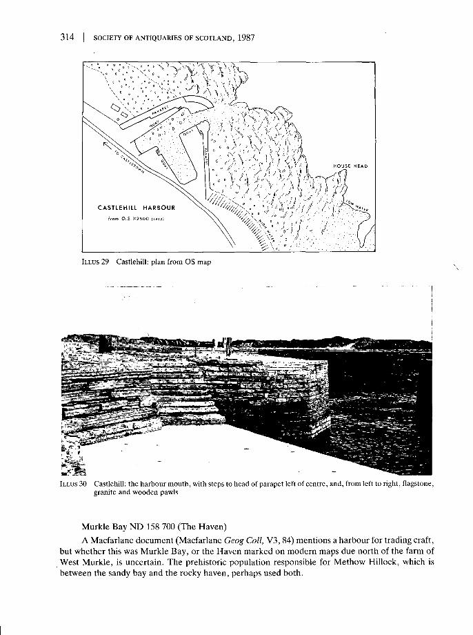
314 I SOCIETY OF ANTIQUARIES OF SCOTLAND, 1987
HOUSE HEAD
C A S T L E H I L L HARBOUR
from O.S.l:2500 IW66)
ILLUS 29 Castlehill: plan from OS map
ILLUS 30 Castlehill: the harbour mouth, with steps to head of parapet left of centre, and, from left to right, flagstone,granite and wooden pawls
Murkle Bay ND 158 700 (The Haven)A Macfarlane document (Macfarlane Geog Coll, V3, 84) mentions a harbour for trading craft,
but whether this was Murkle Bay, or the Haven marked on modern maps due north of the farm ofWest Murkle, is uncertain. The prehistoric population responsible for Methow Hillock, which isbetween the sandy bay and the rocky haven, perhaps used both.

GRAHAM AND GORDON: OLD HARBOURS IN NORTHERN AND WESTERN SCOTLAND 315
ILLUS 31 Castlehill: sea wear on the tiered verticalflagstones, some five feet high, set by Bremnerto form the slightly battered outer face of thenorth-west pier. The whitish patch (centre top)is repair work in cement to characteristic mid-section damage
THURSO ND 121 684 (illus 32)The harbour of Thurso lay in the mouth of Thurso River. Two sloops were recorded here by the
Cromwellian Commissioner Tucker in 1656, the next to the south being one of 16 tons at Cromarty.According to a Macfarlane document of 1726, the harbour could be entered by barks of 60 tons,though pilotage was necessary on account of a dangerous rock (Macfarlane Geog Coll, VI, 172).Once inside, they could lie in safety. A companion document (ibid, V2 243) alludes to a trustworthyanchorage (portu quoque et statione fida). At the time Thurso was engaged in import and exporttrading (ibid V3,84). A customs establishment for the whole coastline from Helmsdale to the Point ofStoer had been set up at Thurso in 1707, and the port legalized, but still in 1734, an Invernessmerchant wrote to John Sinclair of Ulbster, the superior, 'Mr Brody was much wrong to impose onme by assuring me that here was a convenient harbour in Thurso River, whereas there is none fit fora vessel' (Waters, 1). In 1798, though the river was busy with overseas trade, the main anchoringground seems to have been off Scrabster, though the harbour there was 'indifferent' (SAS Thurso,V20,493,521). In 1800 the first bridge was built over the river to Thurso town, on the west bank, thenbeing developed by Sir John Sinclair. His efforts to enable Thurso to participate profitably in the rise

316 | SOCIETY OF ANTIQUARIES OF SCOTLAND, 1987
of the herring fishery, as at Wick, failed. Though an Act of 1802 authorized the building of a harbourfor ships of up to 800 tons at spring tides, a weir, a graving dock and a slip for ship-building, and theBFS would have paid £1000 towards the £7000 cost of a plan produced by Telford, the required £6000could not be raised locally. By 1825, however, Thurso had 17 vessels totalling 1035 tons, and wasbuilding three more (Waters, 3), and successfully resisted an attempt to remove the customsestablishment to Wick. The first shoremaster was appointed, and pawlage charges of one penny a tonwere fixed for the use of mooring poles in the river mouth, the proceeds to be used for dredging thechannel. The export of Caithness flags for paving stones, begun in 1825 from Castlehill, led toincreased use of Thurso River harbour facilities. In 1835 the Board of Customs laid off andapportioned the use of all river banks within the boundaries of the port of Thurso, construction ofharbour works was inhibited by expense until after 1850. In 1840 the limit of draught for ships inThurso River was said to be 12 ft (3-65 m). At that date 14 ships were owned in the port and otherstraded there (NSAS Thurso V15, 7, 9). The paving stone merchants modified the right bank of theriver progressively from 1825. A succession of five walls on the river frontage, behind which, partly bydeposition of chips from the stone yards, land was built up, reclaimed an area of 30 to 40 acres before1876. Ships tied up to the rough quays so formed, and at low tide were grounded upright (Waters, 6,illus). On the left bank, however, it was still possible, in the hunger of 1847, for two sloops and a largervessel to be dragged up the beach by a mob, to stop carts in Shore Street arriving to load bread cornfor export. (Information by courtesy of Mr J Humphries, Thurso.) The Report of the ParliamentaryCommision on Tidal Harbours of 1847 provides a plan covering the whole of Thurso Bay, includingScrabster (Harbours App C, 376, xlii).
StructureOn the right bank, further up than the present left-bank harbour, one stretch of stone revetment
appears older than adjoining modern works. Still further up, there is a square quay of very rough masonry.From each bank, just below the bridge, there is a ridge of wasted masonry projecting towards the middle ofthe river, and retaining a pool at low tide even when the river itself is very low, which could have been usedby boats in early times (illus 32).
SCRABSTER ND 100 703 (at corner of bay)This note should be read in conj unction with the one on Thurso, for which port Scrabster served
as the main anchorage. The harbour here too was indifferent, though safe when the bar was passed;
ILLUS 32 Thurso: the pool in Thurso River corresponding perhaps to the ship-poolof Wick

GRAHAM AND GORDON: OLD HARBOURS IN NORTHERN AND WESTERN SCOTLAND | 317
but it only admitted vessels of 10 ft draught, and that only at high water (SAS Thurso, V20, 496).Loading and unloading were possible only at high water for lack of a stone pier or breakwater; ringsset in the rocks, and mooring poles seem to have been ineffective. The quality of the anchorage hadalready been noted in 1726, and the shelter provided for it by Holburn Head (Macfarlane Geog Coll,1, 172).
StructureBetween the sea and the road from Thurso, before this reaches the modern inner harbour of
Scrabster, the foreshore of the corner of the bay is revetted with masonry, the blocks being smaller thanthose used for the adjoining harbour works. At the harbour end of this embankment there is a slip serving aboat-repairing yard. These works appear to predate the main inner and outer harbours, but may be laterthan 1850.
Brims ND 039 710Port of Brims is the natural haven to the east of Brims Ness and served Brims Castle. See
Crosskirk of Forss for complementary haven.
Crosskirk of Forss ND 029 700This haven, sheltered from the east, served the early settlement at the mouth of the Forss
Water, and the later quarry operations on and near the shore.A plan dated 1840 (RHP 1222), probably the work of J Mitchell, shows a pier 285 ft (86-8 m)
long and 15 ft (4-6 m) wide with a return head of 108 ft (33 m) on the right bank of the Forss Watermouth. A parapet wall and foundations and protective sloped backing of equal width to the piersurface are also shown on its east side and northern end, but it is not known whether this pier was everbuilt. No trace remains on modern maps. Quarry debris is strewn over the area to which the planrelates and almost smothers a raised roadway across the head of the inlet leading to a 19th-centuryhouse.
SANDSIDE NC 958 660 (illus 33)This site, though primarily a fishermen's landing used also for local coastal trade, is worth
notice here for its 'very neat and commodious harbour' referred to in the New Statistical Account(NSAS Reay, V15, 20). The proprietor who paid for the building of the 'small artificial harbour'(Harbours, xli) was William Innes of Sandside. His letter of 5 December 1835, expressing hissatisfaction with the completed work was published by Bremner in 1845 (Bremner 1845, App 5, 47).Bremner secured the harbour by the use of boom gates (illus 33).
StructureThe joint mouth of the Sandside and Brackside Burns is backed up by dunes in the head of Sandside
Bay sufficiently to have afforded, in early times, a pool or pools to shelter small craft, between the village ofReay and the sea. About half way along the west side of the bay, rock shelves lying at right angles to theshoreline have been flattened and the inner end of one shelf cut back to form a primitive quay. A shortdistance to the north, the two piers of Bremner's harbour have improved a pocket in the rocks, making asmall harbour with a very narrow entrance to the north-east. Both piers are backed with vertically setflagstones. The north pier is constructed throughout mainly of these, but the surface has massive lateralkerb stones. It extends out to sea beyond the narrow entrance, the head returning southwards at an obliqueangle. The outer tip is stepped. Near the end of its heavy parapet, there is a shelter recess. Eight cylindricalstone pawls are set in the surfaces of the pier and shore quay. Unlike Castlehill where the boom closurerequired two slots on each side of the harbour mouth, Sandside has only a single pair. There are remains ofthe machinery for working the gates on both sides.

318 | SOCIETY OF ANTIQUARIES OF SCOTLAND, 1987
ILLUS 33 Sandside: the harbour mouth, with remains ofboom machinery. The slot is just visible as a nickin the kerb edge below and to the left of the ironbar. The tip of the north pier is under repair
TONGUE
The Kyle of Tongue is a narrow inlet of the sea, nearly eight miles long. It was marked on thechart used by French ships in 1745-6, Le Neptune Francais. The sloop, Leprince Charles, was trappedon Melness Sands on the west shore near the mouth of the Kyle, while trying to land men and moneybefore Culloden (Gibson 1967, 2). Tidal sandbanks diminish the utility of the inlet as a whole, but itwas mentioned as a place of shelter in 1847 (Harbours, xlii). The individual landings that it containsare listed below.
Melvich Blay and Portskerra NC 882 657The mouth of the Halladale River was recorded in 1793 as the best harbour in the parish (SAS
Reay, V7, 571). Small decked craft could lie there at the south-west corner of Melvich Bay in safety.Pools backed up by blown sands are characteristic of this site. The bay itself is exposed to the north.The modern harbour below the village of Portskerra is approached by an old road, which descendssteeply to the west shore of the bay, at the point where the sands give way to a rocky foreshore. Somedebris of an older pier remains at the angle between the road and the head of the modern pier. WhenBremner remarked that, 'at Portskerry [sic] an excellent and convenient harbour may be constructed. . . at a moderate expense of from £7000 to £8000. . .with a depth of 36 ft of water at the lowest ebbs'(Bremner 1845, 31), the reference may have been to this site or, perhaps more probably, to SkerrayBay.
PortskerryAn older form of the name 'Portskerra' (see last entry), used in 1847 (Harbours, xliii) for this
fishing village. The 'port' may have been, originally, the bay between the rocky promontories of

GRAHAM AND GORDON: OLD HARBOURS IN NORTHERN AND WESTERN SCOTLAND 319
Rubha Bhra and Rubha na Cloiche, or any of the inlets in the heavily indented shores about RubhaBhra, which provide, at most some shelter in fair weather.
Armadale NC 783 651 Kirtomy Bay NC 745 643 Skerray Bay NC 660 631 Talmine NC 588 632In 1845 Bremner wrote that the harbour building he had been employed by the Duke of
Sutherland (on Telford's recommendation) to plan for these four places had not been carried out, dueto 'posterior adventures in the herring fishery' (Bremner 1845, 31).
Armadale resembles Portskerra as to natural features, but lacks a pier, having only a track tothe shore at Port a Chinn so steep that fish boxes are today winched up the cliff.
Kirtomy Bay is rock bound, exposed to the north, and only partially sheltered to the west by along narrow island, which forms the western horn of the bay.
Skerray Bay has a modern pier, 200 ft (61 m) long and 20 ft (6 m) wide. This may preserve theshape of Bremner's planned construction. Its 70 ft (21-3 m) return head is at the 25° angle to waveimpact which he preferred (Bremner 1845,13). There is an old kerb at the shore end of the new slipbeside the inner south side of the pier. The roadway reaching the pier round the south-west curve ofthe bay is supported by a wall of rough stone blocks rising about 5 ft (1-5 m) from the beach. Thenorth-east horn of the bay ends in a spur of low rocks, Cam Mor, in which there is an opening sostraight as to appear likely to have been man-made or modified, and through which at high tide asmall boat could pass in or out of the channel, Caol Beag, south-west of Neave or Combe Island and inits shelter.
Talmine looks out to the Rabbit Islands, about a mile off shore. These afford some shelter fromthe north-east to its wide-mouthed bay. Eilean Creagach rises from tidal rocks very near the northend of the bay, and is now joined to the shore by a pier.
Port Vasgo NC 585 651This place is less than two miles from Talmine, near enough, perhaps, to suggest that develop-
ments here may have been substituted for proposals originally relating to the Bay of Talmine. (Seelast note.) On the west side of the rocky north-facing inlet of Port Vasgo, beds of flagstone have beenquarried as near to the sea as at Castlehill. Small houses built of this stone stand at the head of the bay.A roadway, much broken, formed of the same stone, rises very steeply across the face of theprecipitous south side of the bay. A map of 1833 (Burnett & Scott 1833) shows a quarry on theheadland to the north-east, possibly connected to the haven by this road. The only sign of harbourwork is a channel, about 4 yd (3-6 m) wide, providing a passage between the rocks from the shore outinto deeper water. This is still used by fishing boats.
Bettyhill NC 695 620 (Centre of Torrisdale Bay)The village of Bettyhill occupies the neck of a promontory between Farr Bay and Torrisdale
Bay, and has old roads to places on the rocky shores on each side, beyond the sands of the bay heads.Torrisdale Bay receives both the Naver and the Borgie Rivers. The ridge of Druim Chuibe betweenthe river mouths is surrounded by an extensive accumulation of dunes and flatter sands. Remains ofan early settlement in the sands on the left bank of the Naver, a broch on the ridge above, and achambered cairn on its west side are evidence that the river mouths attracted population in early timesto an area capable of sheltering small boats as required.
Tongue Ferry NC 581 585Bremner records that he erected four passage-boat piers for Tongue Ferry. He refers also to a
plan to connect 'the Island of Tongue with the mainland, by an earthen mound, whereby a chain boat

320 SOCIETY OF ANTIQUARIES OF SCOTLAND, 1987
might pass with safety' (Bremner 1845, 31), a scheme also mentioned in the New Statistical Account(NSAS Tongue, V15, 180).
There are still two piers on each side of the Kyle. On the east bank, Tongue House has its ownpier, and there is a slip facing south where a modern causeway runs on westwards from the end of anapparently natural promontory. This slip is of large stone blocks, with a kerb providing a long-short-long key for the pavement of similar blocks. Large old iron rings are in place in the pavement. The twowest bank piers are close together in the shallow bay of Achuvoldrach, to the south of the sands ofAchuvoldrach Burn mouth. The Island was near the west shore, and is now beneath the causeway.The unrealized plan was to have connected it with the east shore, 'the mainland' to anyone approach-ing from Thurso and points south.
LOCH ERIBOLL
This is a major inlet of the sea, between eight and nine miles long and narrowing from a wideentrance. Already in 1726 it was regarded as an excellent roadstead for ships of the largest burden, inwhich the whole British Fleet could ride safely - as was exemplified by the Battle Fleet from Scapa in1914. Today, fishing boats may be seen at anchor off Port nan Con whenever gales interrupt theirworking off the north shore. The good anchorage was noted in 1847 (Harbours, xlii). Individualminor landings within the loch are listed below.
Upper Roadstead NC 396 554The name, which appears on OS maps, suggests that vessels may once have sheltered here, as
they do at present off Port nan Con pier, and among the islands in the mouth of Loch Eriboll; alsocorrespondingly in the shelter of the Rabbit Islands in the mouth of the Kyle of Tongue.
Heilam-Port nan Con Ferry NC 447 596The A838 road descends steeply to the shore of Loch Eriboll about a mile south of Heilam. An
old road branches off northwards, makes a hairpin turn near the foot of the slope and turns againwestwards crossing to Ard Neackie on what may be an artificial causeway. The terminal of the formerferry is a slip projecting south-east into the sheltered water between Ard Neackie, the causeway andthe shore.
Port nan Con NC 427 603Formerly the terminal of a ferry from Heilam. The modern pier may be connected with a
disused quarry.
RISPOND NC 451 652 (illus 34; 35)Of Rispond, which stands on the west side of the mouth of Loch Eriboll, some modest
developments are recorded (illus 34). Thus, in 1792 two sloops, presumably largish fishing vessels,which had been built in 1788 and 1789 in the neighbouring Bay of Durness, were working out ofRispond (SAS Durness V3, 581). Again in 1834, the harbour contained a basin and a pier at whichsloops could load cargo, with mooring rings set in the adjoining rocks; but it was not considered verysafe in north-easterly gales or at spring tides (NSAS Durness, V15, 94). Bremner lists Rispond withTalmine and three other small havens as sites of harbour works for which he made plans for the Dukeof Sutherland (Bremner 1845,31). In 1845, however, the prospects of the fisheries on this coast wereso bad that no harbour building was being done.

GRAHAM AND GORDON: OLD HARBOURS IN NORTHERN AND WESTERN SCOTLAND I 321
ILLUS 34 Rispond: plan
ILLUS 35 Rispond: large rough blocks in the outer wall ofthe closed pool of this harbour. Below the figure,the stump of a wooden post is set in a bulge ofeven rougher masonry, possibly the remains ofone side of the former entrance, with its pawl

322 SOCIETY OF ANTIQUARIES OF SCOTLAND, 1987
StructureOne large iron ring set in the face of a rock is the only feature of Rispond harbour which it is easy to
recognize from the foregoing account. The land approach to the narrow tidal inlet is by a side turning fromthe main coastal road, making a steep descent south-eastwards to a small area of level ground on the leftbank of the head of Rispond Bay. The bank of the inlet is revetted to form a low quay, from which a straightpier of neat stone blocks projects at right angles. All this dries out at low tide. A pier store house is built intothe bank which rises steeply from the rocky shore just beyond the head of the pier, blocking the way furtheralong the shore to all but agile pedestrians. Beyond this, the one large ring is set in the face of a rockyoutcrop, in which there is an embrasure, possibly man-made. The outer basin, to which there is no trace ofa path, consists of two arms of very rough masonry, at least 5 ft (1-5 m) thick. These meet, enclosing an areaof the foreshore. The basin dries out at low tide. The rough masonry is of various kinds, some clearlymodern, and may once have been quite differently shaped (illus 35). The OS 6-inch map of 1906, surveyedin 1878, marks the inner pier as it is today, but further out only a narrower projection, at or near the site ofthe inner (western) arm of the existing basin, but apparently rather longer. The basin mentioned in 1834can have been defined only by the, mainly natural, indentation in the shoreline between the two piers,where rings were noted, and survive. The outer pier may have disintegrated or been dismantled, and theboulders of which it was built reused in the present structure, possibly a pool serving the lobster fishery.
Smoo NC 420 675Noted in 1726 as having a harbour suitable for large boats at the mouth of the burn (Macfarlane
Geog Coll, 1, 192). The burn, however, runs out into a very narrow crack in the precipitous cliffssurrounding a well-known cave. The old road descends to a point on the west side, about half-way tothe narrow entrance of the inlet. Large boats would always have been at risk here.
DurnessThe Kyle of Durness was noted, but only as a natural inlet, in 1847 (Harbours, xlii). A ferry is
marked on the OS map at Keoldale NC 380 661.
Port Odhar NC 358 710Shelter from the north-west, which could be much needed here in the mouth of Balnakiel Bay is
available at Port Odhar, though far from any inhabited place (NSAS Durness, V15, 94).
Clashcarnach NC 272 736A slip, apparently for the service of the Cape Wrath lighthouse, noted in 1834 (ibid).
THE NORTH-WEST COAST: CAPE WRATH TO LOCH LINNHE (illus 36)
This stretch of coast is treated here as a unit on account of the general similarity of naturalcharacteristics which obtains throughout its length, and also of its general lack of important sites. It isto this region, in particular, that the warning given in the Introduction chiefly applies, regarding thelarge number of natural refuges and landings in common customary use that the broken and deeplyindented shore-line provides. Another point of similarity emerges if the character of the sources isconsidered. These consist in the main of the two Statistical Accounts. It will be found that, in theirtreatment of the parishes of Durness, Edderachillis, Assynt, Lochbroom, Gairloch, Applecross,Loch Carron, Kintail, Glenshiel, Glenelg, Arisaig and Moidart, Ardnamurchan, Sunart andArdgour all the authors concerned invariably use 'harbour' of any protective inlet, without the leastintention of suggesting, as in modern usage, the presence of artificial works. Such major naturalfeatures as, for example, Loch Laxford and Loch Ewe are included by name among the harbours oftheir respective parishes. This may well confuse a reader, while again some of the names mentioned

GRAHAM AND GORDON: OLD HARBOURS IN NORTHERN AND WESTERN SCOTLAND 323
ernera^^?V*Glenelg Ferry
ILLUS 36 Map of the north-west coast

324 SOCIETY OF ANTIQUARIES OF SCOTLAND, 1987
cannot now be identified at all. The descriptive notes and list entries given below are accordinglydesigned to apply only to those landings or, for that matter, sea lochs, about which some facts ofpositive interest are recorded.
Of these, Ullapool stands out because the history of its development by the BFS is com-paratively well documented. The origins of this development preceded by two decades the Society'sadoption of Wick and the east coast fisheries, where achievements in the 1830s and 40s so farsurpassed those in the west.
Highland cattle-drovers made use of certain customary landings, though here, as on the south-west coast, few piers were built for that trade. Ferry terminals where surviving structures datablebefore 1850 have been found are also very few, in spite of the once-great dependence of communica-tions in this area upon ferries.
Scourie NC 155 450The setting-up of a fishing station at Scourie was 'contemplated' (Henderson 1812b, 126). The
New Statistical Account, however, includes the statement that, in the parish of Edderachillis therewere natural harbours only (NSAS Edderachillis, V15, 118).
Kylestrome-Kylesku Ferry NC 230 338The pier on the north shore of the narrows where Lochs Glendhu and Glencoul open westwards
into Loch Chairn Bhain shows no old work, but some courses of old stone blocks may be seen belowthe modern coverings of the south bank pier.
Unapool NC 238 327For a few years before 1820, marble quarried at Ledbeg was brought down to Unapool on
'tracts for the heavy waggons', and exported by a native of Newcastle (NSAS Assynt V15,114). (Onearly waggonways, see Broad 1981, and, for a much shorter 'railway', Brora supra.)
LOCHINVER NC 093 223The fishing station of Lochinver was owned by Macdonald of Skeabost who, from 1816 to 1848
also owned Isle Ristol, fomerly the property of the BFS (Dunlop 1952,272). Consequently, the NewStatistical Account (1837-40) includes references not only to safe anchorage here, but also to a smallconvenient harbour, where 'a pier has been erected' (NSAS Assynt, V15,115). Lochinver had beenone of the 'maritime villages' where development was earlier contemplated (Henderson 1812b, 143),and on a map from Dunrobin (Burnett & Scott 1833) its roadstead is shown with several ships.
StructureThe new pier (1969) has covered over the site beyond the mouth of the River Culag to the south of
the village where older OS maps marked a pier. The embankment of the road from Culag Bridge along theshore is of medium-sized blocks, quite neatly set, and may preserve the type of the masonry of the old pier.The shoreline of the head of the Loch contains several well smoothed rock landings, the best being in asmall inlet below the church.
ULLAPOOL NH 128 938The town of Ullapool in Coigach occupies a triangular promontory projecting nearly half a mile
southwards into Loch Broom about one-third of the way along its south-western shore. Theanchorage south-east of the town is thus the safest in the whole loch, the whole of which affords muchvaluable shelter. The pier is a mere adjunct to a natural harbour very similar to others in the sea lochsof this region.
GRAHAM AND GORDON: OLD HARBOURS IN NORTHERN AND WESTERN SCOTLAND 325
Ullapool and its harbour reflect in their development a wide historical spectrum, partly becausethe route of the present A835 is the easiest land exit from any point on the north-west coast towardsInverness, Edinburgh and London. By 1745, a proprietor from the east, the Earl of Cromarty, hadalready replaced the local MacNicol. Loch Broom was the furthest north point of the voyage of theFrench ship Le Hardi Mendlant, which bore to France the news of Culloden (Gibson 1967,42). TheLoch was the scene of several naval actions during the Rebellion and its aftermath. In the accounts ofthese quoted by Gibson there is no mention of any pier or jetty, or even of a settlement at Ullapool.George, third Earl of Cromarty (a descendent of the pier-builder of Portmahomack), was a moreactive Jacobite than some of his west coast neighbours. The attention consequently paid to the area bythe Commissioners for the Forfeited Estates (Dunlop 1952, 60), and especially their encouragementof road-building, may, though their settlement of 12 veterans at Ullapool failed, as did their linenindustry nearby at Lael, have been among the reasons for the inclusion of Ullapool in the itinerary ofthe BFS tour of 1787. This was undertaken by representatives of the Society for the purpose ofselecting a site for a fishing port on the north-west coast. As Dunlop, whose account of Ullapool willbe followed from here on, says (Dunlop 1952, 7), economic theorists at that time favoured bringingpeople together in large villages, where division of labour might make possible production of goodsfor market. Hoping, apparently, to attract elements of the reduced and unsettled Highland popula-tion into such a village in preference to the migration which so many chose after American Indepen-dence in 1783, the Society purchased, in 1787,1300 English acres at Ullapool from the proprietor ofCromarty, by then Lord Macleod. The nearest Customs House was then at Fort William, with anoutpost on Isle Martin near the mouth of Loch Broom, which became independent in 1789. IsleMartin was mainly a fish curing station, and the Collector and Surveyor lived at Ullapool. It may be anindication of wider trading interests in this area that the Commissioners for the Forfeited Estates hadgranted a 41-year lease of Isle Martin to John Woodhouse, a merchant of Liverpool.
Another significant incomer at this time was Robert Melville, nephew of a fish merchant inDunbar, who chose to settle at Ullapool in preference to the West Indies, and in 1788 contracted tobuild the village for the Society to house its settlers. Melville angled for every advantage available tohim from his experience of the different way of life of the south and east of the country. VisitingLondon in 1789, he achieved the siting of a pier and breakwater half way along the south-facing shorefrom the Point of Ullapool, immediately opposite his own store house. (The jetty shown on the OS1:2500 map of 1968, at the east end of the village, may have occupied the site of the landing place fordroved cattle from the islands, for which Haldane records Ullapool as one point of entry (Haldane1952, map).) Melville contracted to build a structure designed by Call, a director of the BFS, whichwas to be 136 ft (41-4 m) long, 20 ft 9 in (6-3 m) broad, with a T-head 24 ft 6 in (7-5 m) broad. The sides,battered one in six, were to rise to 8 ft 10 in (2-7 m) above the level of high water at the land end, and21 ft (6-4 m) from the mud at the pier head, where 4 ft (1-2 m) would be clear of the water at thehighest spring tide. Further out, beyond the head of the pier, and parallel to the shore, a breakwater137 ft (41-7 m) long, 15 ft (4-6 m) wide, and 1 ft (0-304 m) higher than the pier, was to be built. Nopreliminary survey was carried out, and the foundations spread outwards on the soft sea bed, so thatthe finished pier was larger, and the breakwater had to be built further out than had been intended.Telford, appointed engineer to the BFS in 1790, was nevertheless satisfied with the pier, onlycriticizing the breakwater for being too big. Shingle soon began to be washed up against the pier, sothat modifications were made, with some success, in 1794. The completion of the pier and break-water, as originally planned, in 1790, was announced by the BFS in an advertisement for settlers,printed in May of that year, which described the existing amenities, firstly 'An excellent HAR-BOUR, which is now improved by the addition of a Pier and Breakwater, at the Society's expense'.(Original kindly made available by Mr A Paterson, Ullapool.) Until the herring left Loch Broom, and

326 | SOCIETY OF ANTIQUARIES OF SCOTLAND, 1987
migrated, at the turn of the century, round the north coast into the North Sea, ships came to buy thesalted fish, many from Ireland having nothing to bring except ballast. This was used to make up theground of the Society's village, and is still traceable in its gardens. (Information by courtesy of Mr APaterson.) But the settlement did not thrive. Ullapool boats followed the herring to Caithness, butthey were not built for deep-sea fishing. In 1846 the harvest also failed, and in 1847 the DestitutionFund Committees took over at Ullapool from the BFS, itself in decline ever since the institution of theBoard of Commissioners for the British White Herring Fishery by the Fisheries Act (48 Geo iii, c 110)of 1808. The Customs House was removed, and in 1847 the BFS sold all its western settlements,including Ullapool which fetched £5250. This money was used partly to finance improvements to theharbour of Wick.
No structure datable before 1850 is visible. Recent harbour works have extended over the siteof the 1790 breakwater, which was formerly connected to the pier by a bridge.
Little Loch Broom: Scoraig NG 999 962 Badluarach NG 996 937Jetties are marked on OS maps at Scoraig on the north and at Badluarach on the south shores,
near the mouth of this Loch, suggesting a former ferry.
Laide NG 906 912Boulders have been cleared from this rocky shore, and the landing place known as Laide Jetty
is, in fact, a pier of large stone blocks, much altered in modern times. Droved cattle from Lewis cameashore at Gruinard, perhaps most usually at Laide, where there is also a chapel (Haldane 1952, map).
Gruinard NG 900 925A place on the itinerary of the BFS tour of 1787 (Dunlop 1952, 57). Gruinard Bay had been
visited by French ships in 1745 (Gibson 1967, 93). It is not clear whether the BFS considered thelanding place near Gruinard House, where a jetty is marked on OS maps, or the outfall of LittleGruinard River, or the site of Laide Jetty.
Loch EweThe head of Loch Ewe was described as a 'big, beautiful bay' by the Chevalier Dupont, who
landed at Kinloch near Inverewe in 1745 on the fourth attempt to rescue Prince Charles Edward(Gibson 1967, 84). The advantages of Loch Ewe as a natural harbour led to its use as the terminal forthe packet boat to Stornoway by which the BFS party travelled in 1787 (Dunlop 1952, 57). Landingplaces in Loch Ewe are listed below.
Aultbea NG 868 888The BFS tour in 1787 inspected Aultbea as a possible site for a fishing port, but found
landowners unwilling to sell (Dunlop 1952, 56). Droved cattle from Lewis were landed at Aultbea(Haldane 1952, map).
Poolewe NG 858 808The place-names suggest that small craft sheltered within the tidal reach inside the mouth of the
River Ewe, between the farm of Shore on the right bank and Pool Crofts on the left. Droved cattlefrom Tarbet, Harris, were landed at Poolewe (Haldane 1952, map). The BFS tour in 1787 visitedPoolewe, but considered it unsuitable as a site for a fishing port. The advantage of its being nearerthan Ullapool was to Tain was outweighed by the greater distance of Poolewe from the open sea, andits lack of a suitable site for a village (Dunlop 1952, 57). In 1836, the New Statistical Account of

GRAHAM AND GORDON: OLD HARBOURS IN NORTHERN AND WESTERN SCOTLAND | 327
Gairloch parish (NSAS Gairloch, V14,99) mentioned the harbour of Poolewe, and also the need for aroad from Loch Maree to the bridge over the River Ewe near its mouth.
Loch GairlochShelter is available for small craft among the islands lying near the sharply indented shore line of
the head of this loch, and evidence of early settlement here survives. Cod and ling fishery was beingoperated as a private scheme in 1782 by Sir Hector Mackenzie of Gairloch (Dunlop 1952,148). Theplace was visited by the BFS tour in 1787 (ibid, 56).
Charlestown on Gairloch NG 810 750About a mile north of the head of the loch, the Flowerdale River runs into a small, sandy inlet,
sheltered by a rocky promontory. A short pier extends south from a triangular quay which fills anoblique angle in the shoreline, where sand ends and rocks begin. The pier is built of rough courses ofmedium-sized blocks, with the unusual feature of a raised kerb. On the opposite shore, there is a slip,rising to an embankment below a 19th-century house.
Loch Torridon, Loch Shieldaig and Upper Loch TorridonThe head of Upper Loch Torridon is the site of a settlement, Annat, with a chapel, charac-
teristically well placed to benefit from shelter for small craft in the sandy pools at the mouth of theTorridon rivers. Several piers are marked on OS maps on both sides of the loch, beyond these sands.None of the traditional landing places on this whole arm of the sea has, however, been developed bythe building of a harbour. Land access is more difficult even than to Gairloch to the north or LochCarron to the south. It is an indication of the strength of the movement for the development offisheries in the late 18th century that there was, in 1788, a Torridon Company which, since 1783, hadbuilt a wharf and stage, salt curing and storage houses at Torridon (Dunlop 1952,146). The place wasvisited by the BFS tour in 1787 (ibid, 48).
Loch Carron and Loch KishornThese lochs contained traditional landing places only. Even at Strome Ferry (NH 863 353) no
terminal works had been built in 1841 when Lord Cockburn described it as 'picturesque, . . . and aswell managed as mere hands without proper boats, piers, or any apparatus, can ever manage a ferry'(Cockburn 1888, 129). Strome Castle commanded the northern acces to the ferry.
Loch Alsh ferry to Kyleakin and Bernera-Glen Elg ferry to Kylerhea (illus 37)Telford built piers for both these Skye ferries before 1821 and published plans (Telford 1821,
100) (illus 37). At Loch Alsh, a curved breastwork along the shore 375 ft (114-3 m) long gave on to apier continuing the curve for a further 125 ft (38-1 m). The shoreline at Bernera was also embankedbut with a straight bulwark 120 ft (36-6 m) long alongside which descended a 90 ft (27-4 m) slip forcattle. The 125 ft (36-6 m) pier projected at right angles from the southern end of the bulwark. By1836, steamboats plying from Glasgow to Skye were providing 'almost all the respectable inhabitants. . . with all articles of home consumption' (NSAS Kintail, V14, 178). In 1841, Lord Cockburn,having crossed from Skye, described
'the Kyle, itself beautiful, . . . made gay by fishing boats. It was intended, it seems, to have been asmall metropolis, but like other over-grand building plans, has stuck at about a dozen of two-storiedhouses. The ferry is ill-provided with a boat and machinery for carriages' (Cockburn 1888, 128).
The Skye ferry across Kylerhea met the end of the military road from Glenshiel. Droved cattlewere landed here at Bernera, in the 'good open south country pasture' described by Lord Cockburn in

328 | SOCIETY OF ANTIQUARIES OF SCOTLAND, 1987
Invtrnrfs- sliirt-.KYLE RHEA FERRY PIER
South Side
ILLUS 37 Bernera-Glenelg Ferry to Kylerhea: Telford's meticulous plan(1821)
1841, when he crossed the ferry 'claimed to be the best in Sky' but 'detestable, at least for carriages,and as ill-conducted as possible' (ibid, 114-15).
Dornie NG 880 260Teford built a pier 182 ft (55-5 m) long for the Loch Long ferry at Dornie before 1821 and
published a plan (Telford 1821, 100).
The Sound of Sleat, Loch Hourn and Loch NevisThe coastline here had none but traditional landing places. Naval activity in the area during the
Rebellion is described by Gibson (1967, 15, 49, 119).
Loch nan Uamh and Loch AilortThese natural havens at the head of the Sound of Arisaig saw the landing and re-embarkation of
Prince Charles Edward, and in 1746, the last battle of the Rebellion (Gibson 1967, 14,15, 33^1).

GRAHAM AND GORDON: OLD HARBOURS IN NORTHERN AND WESTERN SCOTLAND 329
KENTRA NM 634 701 (illus 38) and SALEN, LOCH SUNART NM 688 643 (illus 39)'A plan of Loch Sunart &c . . . surveyed by Alexander Bruce' and dated 1733 is stated in the
New Statistical Account (NSAS Morvern V7, 170) to have included harbour plans. Improvingdevelopments by the proprietor of Strontian at this time (ibid, 154) resulted in stone, 'a finemicaceous rock', being carried 50 miles by sea for the building of Corran Ferry piers. The herring leftLoch Sunart in 1818, but it was the BFS which enabled construction of the piers at Salen and Kentraby contributing two-thirds of the cost of £1175 (Harbours, xliv). The project is explained by the writerof the New Statistical Account of Ardnamurchan in 1838 (NSAS Ardnamurchan V7, 152, 157),
Two piers were, a few years ago, erected by the British Herring Fishery Society, one-third of theexpense being contributed by Sir James Milles Riddell, and the whole of an excellent road throughthe Moss of Kintra, by which both are connected. One of the piers is still of some use. . . . The piersbeing situated on the north and south shores of a neck separating Loch Sunart and the Bay of Kintra,it was fancied that, as the point of Ardnamurchan would thereby be avoided, the intercoursebetween the northern isles and the south would be drawn to this line of communication.
Structure: KentraThe pier referred to in 1838 (ibid) is almost intact. It extends about 750 ft (228-6 m) south from the
rocky shore of an inlet on the north side of the Bay of Kentra, then bends about 30° eastwards and continuesfor about 220 ft (67 m) of a plain rectangular end. It is about 20 ft (6-1 m) wide, and its 16 courses of stoneblocks rise to a height of about 20 ft (6-1 m) at the angle. A kerb of irregular blocks, each about 1 ft (0-304m) long, keys into a surface paved with narrow blocks, vertically set, in the centre of which, at the placewhere the angle occurs, there is one large iron ring. Original features intended to strengthen the structureinclude a slight batter on the east side wall, and neatly contrived sections of breastwork, some of which is ofnarrow blocks set at an angle of about 45°, by which the west side is fitted on to natural rock support. At andaround the obtuse convexity on the west side, the breastwork is breached, and the interior masonry can beseen breaking up (illus 38).
Structure: SalenA quarter of a mile south-west of the mouth of the burn at Salen, the pier extends about 300 ft
(91-4 m) along the west side of a small bay and out into the deeper water beyond the rocks on its west sidewhich form the horn of this bay. For the first 50 yd (45-7 m) out from the shore, the pier top which is level,and about 20 ft (6-1 m) wide, is set on an infilled natural rock base (illus 39). The kerb of large rectangularblocks keys into a surface made up of narrow blocks vertically set, crosses the width of the structure at thispoint. Beyond this, the pier top inclines gently towards its head. There is no batter on the east wall of thepier, usually well sheltered and provided with a set of steps descending outwards towards the tip. The westside of the pier is fitted into the natural rock with sections of gently sloping breast work and nearly flat infill,made of narrow blocks vertically set, for the whole of its length, which is greater than that of the east side.The pier end is slanted, making an acute angle with the rock supported west side and an obtuse angle fromthe outer end of the steps on the east. An unusual feature is the survival of three very large iron hooks, oneat least 1 ft (0-30 m) long, secured by rings to the flat-topped rocks beyond the west side of the pier. Therewere also five rings, of which three are intact, inset along the centre line of the pier surface.
Kilchoan NM 494 627Droved cattle from Barra were landed at Kilchoan (Haldane 1952, map). In 1838 the writer of
the New Statistical Account (NSAS Ardnamurchan VI, 156) recorded that cattle were driven south byFort William and by Corran Ferry, and added that Kilchoan needed both a pier and sea marks.
LOCHALINE NM 679 447 (illus 40)Droved cattle from Fishnish, Mull, were landed at Lochaline (Haldane 1952, map). In 1843 it
was recorded that 'Underneath the village, a substantial pier has been constructed by the proprietor'(NSAS Morvern V7, 190), this being the only such work noted in the parish of Morvern.
330 SOCIETY OF ANTIQUARIES OF SCOTLAND, 1987
ILLUS 38 Kentra: broken breastwork on the shore side of Telford's ferry pier. The dressed stone has probablybeen put to other use
ILLUS 39 Salen, Loch Sunart: the courses of Telford's ferry pier are neatly fitted on to the natural rockfoundation, which has not been levelled or stepped. Contrast Portmahomack south pier

GRAHAM AND GORDON: OLD HARBOURS IN NORTHERN AND WESTERN SCOTLAND 331
; „ rf,*i*,'W>.II»
ILLUS 40 Lochaline: the quay
StructureThe pier faces east across the narrows at the mouth of the loch. From the south, it is approached
along 32 ft (9-7 m) of quay, in the north end of which a flight of nine steps descending towards the pier isinset (illus 40). From this point, the quay curves outwards through 90° to form the south side of the 54 ft(16-4 m) square quay. An 18 in (046 m) long block in the kerb is cut to the shape of the curve. A large ironring is set in the surface of the quay, about 2 ft (0-6 m) back from the curve. The south-east corner of thepier head is also curved. Near the north-east corner, there is one old wooden pawl. A slip about 20 ft(6-1 m) wide rises along the north side of the pier. Across the mouth of the loch another, less developed,landing place is visible, perhaps for a ferry.
Corran Ferry North NN 016 637 See Corran Ferry South
THE SOUTH-WEST COAST: LOCH LINNHE TO LOCH FYNE (illus 41)
The point of division between the northern and southern sections of the Atlantic-facing coast ishere set at the head of Loch Linnhe. As a result, the whole southern section, apart from Fort Williamand Lochaber, falls within the former county of Argyll; and where historical matters are concerned, itis the old Argyll that has been kept in mind throughout, and not today's system of Regions andDistricts, as the former possesses associations with bygone conditions which the latter naturally lacks.
The material found in the southern, or Argyll, section of the coast resembles that in thenorthern to a certain, but limited extent. Inlets of sea still have a part to play south of the dividing line,though except in the case of Loch Fyne they are smaller than their northern counterparts and ingeneral less important. The Statistical Accounts are still a main source of information, with theauthors of their articles persisting in their inveterate habit, mentioned above as liable to lead toconfusion, of describing as 'harbours' purely natural inlets when these were used for anchorage, or bylocal fishermen for shelter. On the other hand, the two sections differ greatly in some importantrespects. A better hinterland backs the Argyll section, and its social and political history has beensomewhat less unfortunate than that of the far north-west. Opportunities for development followed

332 SOCIETY OF ANTIQUARIES OF SCOTLAND, 1987
Corran F e r r yB a l l a c h u l i s h
F O R T W I L L I A M
CRINANJlLOCHGILPHEAD
A R D R I S H A I G
T A R B E R TL .Caolisport
// \ __, iSkipness
Ardpatrick /»^xport_jOld Piei _ _a'Chruidh^pBrann a'Prnjirt
KIPNESS BAY
CAMPBELTOWN
Southend
40_I km
ILLUS 41 Map of the south-west coast
naturally from proximity to the Clyde and to the Lowland area, so that fishing was not the soleproductive use of coastal waters and harbours. In the 19th century, and to some extent even earlier,stone and charcoal were being carried by sea between the quarries, stances and ironworks of Argyll(RCAMS 1975, 251).

GRAHAM AND GORDON: OLD HARBOURS IN NORTHERN AND WESTERN SCOTLAND 333
FORT WILLIAM NN 099 738
The 'Port of Fort William' is mentioned in the 1793 Statistical Account (SAS Kilmalie, V8,428),but no particular connection with the Fort seems to be implied. In fact, a purely civilian status seemslikely, as the place possessed a Customs House. A considerable list of imports is given, and wool isnoted as an export. In 1835 a quay had 'quite recently' been built (NSAS Kilmalie, V14,125), moreexactly dated in the Report of the Tidal Harbours Commission to 1832 (Harbours, xliv), the cost beingmet partly by subscription and partly by the BFS. An oil painting by S Bough (1822-1878) in theWest Highland Museum shows a pier, with a timber extension beyond the return head. The word'quay' was applied to piers on some contemporary plans, but it is possible that the pier in the picturewas not built until about 1871, the date of a plan in the West Highland Museum on which it is shown,and that the quay of 1832, about which Mitchell was consulting Telford in 1833 (Gibb 1935,256), mayhave been a different structure, possibly on another site.
A very safe anchorage is noted in the Statistical Account between Fort William and Corpach, atCamusnagaul.
StructureA pier like the one shown in Bough's painting survives projecting north-westwards from beneath the
modern bypass near its southern end. If the quay of 1832 was a shore embankment connected with this pier,it is now under the road. Of the north-east, inner, face of the pier, about 24 ft (7-3 m) remains visible, fromthe head of a flight of stone stairs, descending seawards, to the obtuse angle inside the return head, which isof about the same length as the exposed section of pier. Courses of neatly cut red stone blocks, each about1 ft (0-304 m) by 8 in (0-2 m), are set without visible mortar. The kerb stones are not differentiated, exceptthat some are longer, and some are secured with iron cramps. Old large wooden props support the innerface of the return head. Later additions obscure all but the inner faces.
Corran Ferry NN 021 636Corran is the northernmost of a series of ferries which served the littoral settlements (and those
of the off-shore islands) of Loch Linnhe and the Firth of Lorn. Of these, many have disappeared,Connel and Ballachulish have been replaced by bridges, and only Corran has continued, with fewinterruptions, to run up to the present. No early construction is visible at either terminal. Telford wasconcerned with the building of the piers in 1817 (Gibb 1935, 309) and published plans (Telford 1821,100). Stone from Strontian was brought by sea for the piers, possibly at an earlier date (NSASArdnamurchan, V7, 154).
Ballachulish NN 054 509The sloping ferry piers which were in use until the recent opening of the bridge are of stone
blocks under modern coverings and extensions. In 1898 each pier was 100 ft (30-5 m) long and at most20 ft (6-1 m) wide as shown on the OS 1:2500 map. Mitchell (1883, 183) remembered seeing, inAugust 1837, at Ballachulish, Tn a cove or harbour immediately below the quarries . . . a number ofsloops and vessels, attesting the bustle of business and commerce even in this calm solitude of themountains'.
Laroch NN 08 58A small harbour has been formed out of banks of quarry waste at East Laroch (RCAMS 1975,
277).
Port Appin NM 902 453The ferry to Lismore from Port Appin was mentioned in a Macfarlane document of about 1630
(Macfarlane Geog Coll, 2, 154), and in the two Statistical Accounts (RCAMS 1975, 283).

334 | SOCIETY OF ANTIQUARIES OF SCOTLAND, 1987
Cregan Ferry (Loch Creran) NM 978 443A passenger ferry at the narrows since spanned by a (now disused) railway bridge was crossed
by Lord Cockburn in 1845, but could not take a carriage (Cockburn 1888, 283).
Shian Ferry (Loch Creran) NM 914 431The main ferry over Loch Creran was from North Shian (914 431) to South Shian (909 423). In
1845 Lord Cockburn took nearly two hours to cross, and mentions no piers (Cockburn 1888, 287).
LOCH ETIVEThough it is not itself a harbour in the modern sense of the word, but a long narrow inlet of the
sea, some sites of considerable importance in the present context are associated with Loch Etive.Dunstaffnage Castle, where there was a safe anchorage in the adjacent bay, was built at the mouth ofthe loch in the second quarter of the 13th century (RCAMS 1975, 179) and controlled the strategicroute along the south shore and through the Pass of Brander. On the north shore, the ValliscaulianPriory of Ardchattan was founded in 1230 or 1231 (ibid, 110). The loch must consequently have seen agood deal of maritime traffic, even before the great Lorn furnace was opened on the south shore atBonawe in 1753 (ibid, 283). The lower end of the loch is obstructed by a submerged rocky bar, overwhich the tides rise and fall with violence, but little serious interference seems to have been sufferedas the Falls of Lora thus formed could be passed with safety at slack water. Connel Ferry, across thispart of the loch, was not superseded by Bonawe. The Royal Commission's site plan of the Bonaweworks shows a straight narrow pier about 460 ft (140 m) long, with a slightly expanded end. In 1845,Lord Cockburn found the ferry in operation, but, though 'tourist boats' were also kept on the southside, preferred to explore the loch in a boat 'found' and rowed by 'maritime quarriers' from the northshore (Cockburn 1888, 283-4).
OBAN NM 857 299 (South Quay)Oban originated in the first quarter of the 18th century as a station established in the bay by a
Renfrew trading company. A Customs House was built in 1760 and a ship-building yard followed.The south quay was built for the Duke of Argyll, the proprietor of South Oban, about 1814, at whichdate Henry Bell's 'Comet' was establishing a regular service to Oban from Glasgow (RCAMS 1975,242). In 1843 the port of Oban was described as a safe and commodious harbour, with good quays(NSAS Kilmore & Kilbride, V7 529, 532). Droved cattle from Mull, headed for Oban, were landedon Kerrera and swam across the narrow sound (Haldane 1952, 86).
A plan of the Burgh of Oban by R Stevenson dated 1846 (RCAMS 1975, pi 76), shows thesouth and north piers, both marked 'quay', the shoreline between the two much modified, and a woodyard and some wharfage around the sea frontage of Argyll Square. A slip is marked rising from thebase of the head of the north pier straight along its south-east (inner) side. A slip is visible also inA Stanley's view of Oban in 1857 (ibid, pi 77), curving back, as at the present day, towards the head ofthe bay, away from the line of the pier. A timber extension, like that in Bough's picture of the pier atFort William, is shown standing in deeper water, beyond the pier head.
Loch FeochanA long inlet of the sea, with the entrance obstructed by a sand-bar and only accessible to craft of
up to 60 tons (SAS Kilninver & Kilmelfort, V10, 316). Stone from Ardentallan quarries was used inthe construction of the Caledonian Canal, and there are remains of a roughly formed jetty (RCAMS1975, 277).

GRAHAM AND GORDON: OLD HARBOURS IN NORTHERN AND WESTERN SCOTLAND | 335
Ardmaddy NM 783 155Of two stone-built jetties, one may be the pier known to have been built in 1748 by the company thatworked the nearby Caddelton marble quarry and the Easdale slate. Both are shown on a plan of 1787(RCAMS 1975, 251, 278).
Easdale NM 740 170A harbour was built in 1826 (RCAMS 1975,279). It is constructed of slabs, some vertically set,
of the slate it was to export. (Compare Castlehill, p 312.)
Loch MelfortA long inlet of the sea, considered a safe roadstead in 1794. No landings are mentioned (SAS
Kilninver & Kilmelfort, V10, 316).
Craignish NM 763 005Droved cattle from Kinuachlrach in Jura were landed on the north side of the Craignish
peninsula, close to the mouth of Loch Beag, in the shelter of an off-shore rock to the south-west(NSAS Jura V7, 534, 541). The landing slip, now ruined, was, according to local stories, for men andboats. The cattle were tipped out and swum ashore.
In 1793, open 'birlinns' were being used by Craignish people for trading voyages to the Clyde.To avoid the dangerous passage round the Mull of Kintyre, these craft would use the portage fromWest to East Loch Tarbert (ibid, 449).
CRINAN NR 783 940 (illus 42)The Statistical Account of 1793 (SAS Kilmartin, V8, 93), points to Loch Crinan as the best
harbour in a long stretch of the western coast, stating that 'vast' numbers of craft from both Britain
ILLUS 42 Crinan: the head of the quay. Even the rough boulders have been set toflare slightly at the base and are battered on both the seaward faces of thisstructure. Compare the masonry of the Beilding (Tarbert Loch Fyne)

336 SOCIETY OF ANTIQUARIES OF SCOTLAND, 1987
and Ireland were often detained there as they waited for a wind to take them to the Mull of Kintyre.The writer mentions two anchorages, one below Duntroon and the other behind Eilean da Mheine;near the latter position a small harbour exists today. This state of affairs no doubt changed materiallyeight years later, when the Crinan canal opened, as thereafter Crinan's main function must have beento form that work's northern terminal. Steamers from Oban, Fort William, Inverness and the OuterIslands were calling at Crinan at least as early as 1844 (NSAS South Knapdale, V7, 270).
StructureThe harbour, sheltered by Eilean da Mheine, consists of a roadway along a quay, which has been
built out from the foot of a cliff about 100 ft (30-5 m) high. The rock spurs characteristic of this shorelinemay have been cut or blasted away. The very slightly battered quay front is made of huge, rough, dark greystone blocks, some measuring 2 ft (0-6 m) by 3 ft (0-9 m), of irregular shapes, fitted together with smallstones (illus 42). No old mortar is visible. Large rough blocks, keyed back at 3 yd (2-7 m) intervals, form avery uneven kerb. At the north-east end of the quay, there is a proj ection 30 ft (9 • 1 m) square, from which aflight of stone stairs, nearly 6 ft (1 -8 m) wide, descends back along the face of the quay. One step consists ofa unique slab.
Keills NR 688 807 (illus 43)Droved cattle from Lagg in Jura were landed at a jetty at Keills (Haldane 1952, 95). This,
according to Gibb (1935, 309) was one of the ferry piers with which Telford was concerned in 1817.The landing slip resembles two 50 ft lengths of exceptionally well-made road, one sloping seawardsfrom a low bluff, the other turned at right angles and continuing to slope down the face of the rockyshore to the left. The outer corner at the turning point is built up to 8 ft (2-4 m) from the seabed and
J^^S:- . ;•^^•^..-r%,^.^-^g^^.;̂ . .̂ v^ :̂ • m^.••%r-.'W.... 4*>-»*>• i* •• v*?-§i>-- • r*8 .̂ ws?, .-> ,. * ~,i-i..;*' . .-, •. ̂ * «£A4*y*' ^*^i - -, -Jw* '* " ^SLX „ -
i/->b-c r»rt orliTo irt tVif r»o»;tim^nt r»f T'l^lfr^rH'c dir»\»;a\7 Tl
/ •''-". •. :fci~:' .''.'!̂ :*ILLUS 43 Keills: narrow blocks on edge in the pavement of Telford's slipway. The herring-bone
arrangement at left gives way to fanwise setting of the kerb, which in turn receives lateralsupport from larger flat blocks rammed into the angle. Road building technique is evident

GRAHAM AND GORDON: OLD HARBOURS IN NORTHERN AND WESTERN SCOTLAND | 337
tipped with a kerb block measuring 52 by 21 by 16 in (1 -3 by 0-53 by 0-4 m). This and the entire outeredge of the slip has been secured with an iron strap set in a channel in the kerb blocks, the final sectionbeing notched into the natural rock in which the left side of the sea end of the slip is itself inset. Theslip is paved with narrow blocks, of up to 42 by 10 in (1-06 by 0-25 m) set on edge and forming aherring-bone pattern at the turn, where the surface tips inwards to the shore (illus 43).
About 100 yd (91 • 4 m) to the right of the slip, as one faces the sea, is a curved pier, now ruinousdue to recent vandalism. The stone-work of the pier was never as neat and strong as that of the slip,and it would be interesting to know whether Telford built them both. His own record mentions onlythat he improved the ferry pier in 1808, and again in 1818 (Telford 1821, 50).
Loch CaolisportThe parish minister of 1797 comments on the 'port' place-name (SAS South Knapdale, V19,
310), and his successor of 1840 notes an anchorage (NSAS South Kapdale, V7, 259).
Ardpatrick NR 760 596A natural haven in the mouth of West Loch Tarbert, where it was recorded in 1847 that,
sheltered by the island of Trien, 'revenue cruizers will be found riding safely when the heaviestwesterly gales blow in the Sound of Jura' (Harbours, xlvi).
Southend NR 690 080In 1794 it was recorded that a ferry boat was always waiting here to make the crossing to
Ballycastle in Antrim (SAS Southend, V3, 363).
CAMPBELTOWN NR 722 204Campbeltown was founded by Archibald, seventh Earl of Argyll, in or about 1690, from which
time there dates a Macfarlane document which alludes to a safe harbour (Macfarlane Geog Coll, 2,527). By this expression the bay as a whole was evidently meant, together with the adjacent water inthe shelter of Davaar Island. The place became a burgh of barony in 1697 and a Royal Burgh in 1700.From 1750 to 1786, Campbeltown was the statutory 1 September rendezvous for herring-fishingvessels, the large 'busses' then in common use and qualifying for bounty in terms of the Act, 23 Geo iicap 24 (Dunlop 1952,14, 38). The Old Quay, a pier near the foot of Main Street, was begun in 1722.The New Quay, on which work began in 1754, was 800 ft (244 m) to the south-east. A plan of 1760shows the outer ends of these two piers, each at least 600 ft (183 m) long, curving towards one anotherto form a harbour basin in the shape of a capital D, with an opening of about 150 ft (45-7 m) near thecentre of the curve, where there was a depth of 15 ft (4-6 m) of water at high tide (RCAMS1971,184,pi 73). Dalintober, on the north shore of the bay, lay outside the burgh until incorporated with it in1832, and had acquired a pier of its own about 1767 (ibid, 184). In 1794, Campbeltown's 'excellentharbour' was mentioned (SAS Campbeltown, V10, 552), but again the reference is evidently to thewhole bay rather than to the artificial works. A more explicit account, of 1843 (NSAS Campbeltown,V7, 455), notes that the bay obtains shelter from the land and, on the south, from a bar running outtowards Davaar Island. A very safe anchorage was formed by this conjunction of natural features,and entrance was gained from the north by a deep, narrow channel. At the date in question, 33 sloopsand schooners were owned in the town, together with fishing boats and one large vessel trading toCanada for timber. Other craft served the import and export trade, and steamer connection withGlasgow had been established. The Report of the Tidal Harbours Commission of 1847 describesCampbeltown 'Loch or bay' as a 'well known harbour of refuge', and publishes a plan.
338 | SOCIETY OF ANTIQUARIES OF SCOTLAND, 1987
Structure: CampbeltownRed stone block masonry is visible underlying and disappearing beneath modern coverings at the 30
ft (9-1 m) wide shore end of the New Quay (south-east pier). A slip, double with width of the pier itself, ofthe same stone work, descends parallel with its inner side.
Structure: DalintoberA slightly sloping pier, 200 ft (60-9 m) long and 20 ft (6-1 m) wide, extends into Campbeltown Bay
from its north shore. The top three courses of red stone blocks are neater than those near the base. Thewest side bulges badly, while the east side is composed of several different kinds of masonry. Near the seahead, the corners of which are curved, a set of steps is inset in the east side, descending seawards. There is aslip at right angles to the shore end of the pier, descending eastwards along the sea wall to the beach. Thesurface of the slip is of large cobble stones or setts.
SKIPNESS BAY NR 905 575No less than four landing-places fall under the general heading of Skipness. These are, the Bay,
lying immediately west of the Point, and facing south upon Kilbrannan Sound; Brann a' Phuirt, justnorth of the rocks that form the Point and facing east towards the Sound of Bute; Port a' Chruidh,about a mile to the north, with the same exposure; and the Old Pier, about a quarter of a milenorthwards again.
The bay, in the first place, is an even sandy crescent backed by a storm beach, and whileproviding an easy landing for small boats in fine weather, except when the tide is too low, provides noprotection from the frequent storms that sweep up the Sound of Kilbrannan and offers onlyinconvenient anchorage on account of a wide strip of tidal foreshore. In view of these drawbacks, thesiting of Skipness Castle, less than a quarter of a mile from high water mark, seems surprising, but thepolicies that influenced its builders are quite unknown. On the other hand, a large burn, which nowdebouches by a mouth broken through a storm beach only about 1950, previously ran out at thewestern corner of the Bay, as is shown on contemporary OS maps, and there it formed a tidal poolwhich still, in the 1880s, was acting as a base for three or four herring smacks. About 1814, a wherrywas built, for the laird, Mrs Campbell of Skipness, presumably in a boatyard occupying this same pool(Campbell 1813-14).
Brann a' Phuirt NR 913 574Features of interest in this small inlet, in no proper sense a harbour, are the cutting back of a
rock face so that a boat could lie beside it, and the drilling of three holes at the lip of the rock for thepassage of mooring ropes (Graham & Collingwood 1923, 285).
Port a' Chruidh NR 920 585Local tradition has it that from this small inlet in the rocks, which shows at least one hole bored
for the passage of a mooring rope, droved cattle from Islay used to be re-embarked for shipment tothe mainland. Mrs Campbell of Skipness once landed here in 1813 (Campbell 1813-14).
Skipness Old Pier NR 920 589In 1838 Port a' Chruidh was superseded by a regular harbour, built about a quarter of a mile
further to the north. The purpose of this work was to provide a harbour of refuge for the largenumber of boats engaged on the herring fishery. The Herring Board met one-third of the originalcosts, as well as of the additional sum needed for repairs. The plan and specifications published by theBoard (Reports Commissioners 1840, vol 13, Opp p 17) show that the work consisted of an angledbreakwater pier starting out eastwards from the rocks and then turning north to form a partially

GRAHAM AND GORDON: OLD HARBOURS IN NORTHERN AND WESTERN SCOTLAND | 339
enclosed basin measuring some 250 ft by 200 ft (76-2 m by 60-9 m). The masonry was of dressed stonewith a hard packed rubble core; there was a parapet on the outer edge, and a good deal of rock was cutaway along the landward side of the basin. Though sheltered from the west, the site was, of course,totally exposed to the east. The structure was in ruins long before the end of the century, and the lastof the well-dressed red stone work was demolished by a gale in 1911.
The new pier, dating from the 1870s, falls outside the scope of this study; but it may be worthwhile to record, as a point of general interest in industrial archaeology, that it was built of reused ironrails from the old broad gauge line of the Great Western Railway.
TARBERT, EAST LOCH NR 865 686 (illus 44)Kintyre is attached to the mainland of Scotland by a very narrow neck of land, and for rowed or
sail-driven craft navigating these south-western waters the existence of a portage here was a matter ofconsiderable importance. The distance between the heads of East and West Loch Tarbert is, as thecrow flies, just under a mile, while the detour round the Mull of Kintyre involves a voyage of close on100 miles. The highest point of the neck is 43 ft (13-1 m) above sea level, and a project for a canal wasalready being ventilated in the 1770s (Harbours, xliv). The rounding of the Mull, moreover, involvedvery serious dangers, which are eloquently set out by Bishop Leslie. His translator, Father Dalrym-ple, compares the Muil to a 'nuik or elbock of land, quhair is committed lyke a battel among ye surgesof ye maine Sey fleiting and flowing thairout'. The distance to the Irish coast he puts at only 16 miles,'bot lykewyse for the concurring of ye troublous ebbing and flowing of Sey, surges and wais withuthiris, is verie perilous to the seymen and marinlies' (Brown 1893, 133). Tarbert on the East Lochwas thus a place of importance for fishing and coastal trade; and in periods when trouble was expectedfrom Ireland or the Western Isles it had military significance as well. Tarbert Castle in fact stands asevidence of the strategic aspect of the site, and the oldest part of its remains is dated tentatively to the13th or early 14th century (RCAMS 1971, 180).
The Orkneyinga Saga (ch 41) records that in 1098 King Magnus II of Norway had a skiff hauledover the portage, with the rudder set, in order to prove that Kintyre was an island, and as such part ofhis Scottish domain. A legend likewise exists that Robert I, King of Scots, tried to repeat thisperformance to overawe the western chiefs, but that his ship overturned in the hollow known as Lagna Luing, near the existing Church Hall. In the 16th century the portage was evidently in commonuse, G Buchanan recording that mariners frequently dragged their boats across in order to shortentheir voyage (Brown 1893, 226). A later note shows that this was still being done in 1793 (SASCraignish, VI, 449).
The same is true today, of small local craft and yachts, which may readily be lifted straight fromthe water onto lorries, and thrown back in at the other side. (Information by courtesy of MissCampbell of Kilberry.)
The building of the harbour in East Loch Tarbert in 1812 confirmed the alteration of the shapeof the settlement from that of the burghal nucleus near the Castle (RCAMS 1971,191), focusing it, astoday, on the Loch, with the 'curve of twenty or thirty small houses drawn round its upper end' whichwas admired by Lord Cockburn in 1843 (Cockburn 1888, 198). Telford was engineering improve-ments to piers and breastworks in both East and West Lochs between 1809 and 1813 (Gibb 1935,311).The 'convenient quay' of 1812, built at the joint expense of the proprietor and the government, with abridge and road of approach, served Tarbert as the headquarters of the Loch Fyne herring fishery(Harbours, xliv), when as many as 700 boats used the harbour in the season. The configuration of this'singular and almost land-locked natural harbour' (ibid) made entrance against the prevailingwesterly winds very difficult. The structure known today as the Beilding was built by Telford in 1812-13, and described by him as 'an insulated rock', shaped to form 'a station for capstern apparatus'

340 | SOCIETY OF ANTIQUARIES OF SCOTLAND, 1987
ILLUS 44 Tarbert Loch Fyne: the Beilding
(Telford 1821, 47). It was used for warping vessels into the harbour when the wind was contrary(RCAMS 1971,191), and for drying nets (Cockburn 1888, 191).
(See Jamieson (1818) on various uses of 'beilding', normally connected with shelter.) In 1847 anadditional quay was recorded as having been erected for the accommodation of steam traffic.(Harbours, xliv).
StructureThe Beilding is the least altered remaining structure (illus 44). Modern quays have been built out
further and further into the bay from the original frontage, the line of which is, however, preserved by thehouses facing the Loch along the street beside the harbour.
Modern construction at West Loch Tarbert is probably on the same site where Telford workedbetween 1809 and 1813, but has obscured all traces of earlier building.
ARDRISHAIG NR 850 850 (illus 45-7)The site, on the west shore of Loch Gilp near its opening into Loch Fyne, where the sands of
Loch Gilp give way to a stony and rocky foreshore, resembles in these respects many others in thenorth and west. After 1801, its development was assured by its position at the southern end of theCrinan canal, which was described by the Parliamentary Commissioners for Tidal Habours in 1847 as'a material link in the chain of communication which connects Glasgow and the Clyde with Invernessand the Highlands' (Harbours, xliv). Ardrishaig was then, independently of the canal, 'the mostimportant steam-boat station on Loch Fyne' (ibid), with wharfage popularly considered insufficient.The Commissioners noted a stone pier 520 ft (158-5 m) long sheltering the south side of the harbour,with a light at its head, and on the north a steam-boat pier, about 135 ft (41-1 m) long, built in 1836.Besides passenger traffic, cattle and sheep were shipped, and the herring fishing added to thecongestion in its season. It was recommended that the pier be lengthened and the harbour deepended(ibid, xlv).
StructureThe site is dominated by the terminal works of the Crinan canal, immediately inside the shelter of the
south pier. From this point, the inner face of the south pier, 550 ft (167-6 m) in length, appears to have been

GRAHAM AND GORDON: OLD HARBOURS IN NORTHERN AND WESTERN SCOTLAND 341
ILLUS 45 Ardrishaig: south pier and seat of light. Thefinal lock of the Crinan Canal is visible upperright
ILLUS 46 Ardrishaig: design of beacon for Ardrishaig,1833. This document is behind permanentglass in a frame on the wall of the entrance hallof the Crinan Canal Office, and isdeteriorating
constructed of three distinct types of masonry, presumably at different times. The 130 ft (39-6 m) sectionnearest the shore is built of neatly dressed grey stone blocks of moderate size, set in straight coursesmatching some of the faces of the canal basin. At the sea end of this section there is a bulge (illus 45). Thesurface here is paved with large blocks, in five of which large iron rings are set. Stone steps, about 3 ft(0-914 m) wide descend from the land side of the bulge, back along the inner pier face. The outer (south)face of this section is also much like some of the canal works in general appearance. This slightly batteredouter face is of large reddish rusticated blocks, of which five courses are visible at half tide. Above these,one flat-faced course is surmounted by a string course, and a further three flat-faced courses forming aparapet wall, which culminates in a rounded top-course, once secured by iron clamps. The parapet wall ofthe next section to seaward is of rougher construction. This second section, 270 ft (82-3 m) long, is aligned afew degrees more northerly than the first, and ends where there are remains, possibly of a return head, orperhaps merely of a bulge to accommodate a light or other pier-head equipment (illus 46). In the thirdsection, 150 ft (45-7 m) long and ending at the lighthouse, the pavement matches that of the first twosections, as if, in a final phase of construction, the pier, and the extension called for in 1847, had been muchmodified and repaved.
The north pier, beyond the north side of the canal mouth, is largely covered in by a modern extensionat its sea end. The shore end, still visible for about 60 ft (18-3 m), shows fewer signs of periodic modificationthan is the case with the south pier. Both sides of the north pier, which lacks a parapet wall, are slightly

342 I SOCIETY OF ANTIQUARIES OF SCOTLAND, 1987
ILLUS 47 Ardrishaig: the boatyard slipway from the north pier
battered. Ten rough courses of very large irregular blocks measuring up to 4 ft (1-2 m) by 1 ft (0-304 m)match the construction of the sea wall at right angles to the north side of the pier. The large kerb blockshave rounded edges and key into the much damaged and, in some places, absent surface at irregularintervals. Between the inner face of the north pier and the canal mouth, the shore has been stabilized withsmall, rounded blocks.
Outside the harbour of Ardrishaig, to the north of its north pier, there is a large boat-slip or apron,about 60 ft (18-3 m), sloping down about 160 ft (48-7 m), nearly to low water level, and with an extension atits southern corner ending in a flight or at least five steps, at the foot of which a small boat can still ride atlow water (illus 47). The surface of the slip consists of flattish blocks, showing faces of from 4 to 9 in (10 to23 cm) wide, some being vertically set. Two lines of larger, square-faced blocks, perhaps kerbs of older,narrower forms of the structure, divide the surface, running from shore to sea. One large iron ring surviveshalf-way up the south edge, and there are remains of two more.
LOCHGILPHEAD NR 863 876Lochgilphead is not favoured by nature as a site for a harbour, as it is totally exposed to the
south and tidal sands extend half the length of Loch Gilp. In early times, there was, beyond thesesands, a loch with islets and marshy edges stretching inland nearly as far as Cairnbaan, and capable ofaffording shelter to small craft. Taylor and Skinner (1776, pi 17) mark the road from Inveraray toTarbert following the present shoreline, but give no direction for reaching Oban by turning north atthis point. Lochgilphead, as it developed after the building of the Crinan canal, was served by a smallquay, built by the proprietor in 1813, apparently without grant-aid, and 'useful to a limited extent tothe inhabitants of this thriving village' (Harbours, xlvi). The problem is to identify the remains, if any,

GRAHAM AND GORDON" OLD HARBOURS IN NORTHERN AND WESTERN SCOTLAND 343
of this structure. The 1899 OS 1:2500 map marks a slip directly in line with the foot of Argyll Street, onthe shore of the market stance.
The word 'quay' could well have been used to describe this, or an earlier structure on or nearthis site, but the Tidal Harbours Commissioners also stated that the quay could have been madeaccessible to steamers by straightening and deepening the river. Though the bends in this stretch ofthe river could have been straightened, it would still have been necessary for steamers to negotiate aturn through nearly 90° from their course up the river channel in the length of Loch Gilp. Moreover,the task of dredging would always have been exceedingly onerous. An alternative location may besuggested if consideration is given to the possibility of the first of the surviving structures describedbelow (both on the left bank of the river below its main turn, and thus on the east shore of the loch),having been the 'small quay' of 1813, and the second the 'larger pier' built in 1844, and, according tothe writer of the New Statistical Account of the parish (NSAS Glassary, V7, 693), 'capable ofaccommodating herring wherries and coal smacks'. Straightening and deepening of the river, ascalled for in 1847, may indeed have enabled steamers to reach this pier.
Structure(i) Very rough blocks form an enclosure about 100 ft2 (30-4 m2) in the mud on the left bank of the
river, just below its main bend to the south-east of the town. Faces of short sections only, lookingdownstream, still rise to two or three courses. An old iron upright, perhaps a marker, is set in thedownstream corner, beside an opening to the river front, possibly an entrance.
(ii) About 50 yd (45-7 m) further down the left bank of the river than (i), the pier of 1844 appears tosurvive intact. It is about 30 ft (9-1 m) wide and extends north-westwards some 120 ft (36-5 m), with areturn head of half that length at an oblique angle upstream, that is, due north. The rough block masonry,battered much more on the downstream than on the upstream and river front faces, rises in very roughcourses to a line of uneven kerb stones. These have been secured with iron cramps, of which only slighttraces remain, most of their sockets having been reused for modern alloy cramps. Near the downstreamouter corner of the pier head, one mushroom-shaped metal pawl survives. There are three large iron ringsin the surface of the pier, near the upstream edge. A flight of nine stone stairs, 3 ft (0-914 m) wide, descendsfrom the inner angle of the pier to within about 2 ft (0-6 m) of the base along the inside of the return head.
INVERARAY NN 099 089 (illus 48)Until the middle of the 18th century, the mouth of the River Aray, on the west shore of Loch
Shira at its opening into Loch Fyne, was used to shelter small craft. This landing place servedInveraray Castle, on the left bank of the river, and its associated settlement, and was overcrowdedwith over 400 herring boats in the season. In 1709, the ruinous condition of this harbour was thesubject of a petition by the burghers to the Duke (Lindsay & Cosh 1973,23). A drawing by T Sandbyin 1746 shows boats, one with three masts, beached in the mouth of the Aray. In another Sandbydrawing, of 1747, one boat and some timber wharfage appear in the river mouth, with another boatnearer the present town. With the removal of the burgh to its present site, west of Foreland Point,came a need for a new harbour. In 1754, a project to build a pier at Foreland, or Fisherland, Point,previously the site of the town gallows, was being discussed. In 1756 the Duke authorized the use ofstone from ruined cottages on the site of the new Court House for harbour building. A modest jetty100 ft (30-4 m) long was built by J Adam in 1761, at a cost of 10 shillings and sixpence. A year later,Adam completed the building of a pier to his own plan, but by 1765 the height of the structure had tobe raised (ibid, 267, illus). Thus when the fifth Duke of Argyll, as president of the BFS, led thatSociety's tour in 1787 to select a site for a fishing port in the north-west Highlands, he could draw onlong family experience of the difficulties and costs of harbour building and upkeep. At Inveraray, theharbour wall was built in 1790, and the pier was extended in 1805 under the superintendence ofJ Gillespie (ibid, 267), and again in 1836, when an outer slip was built. It was not clear whether it was
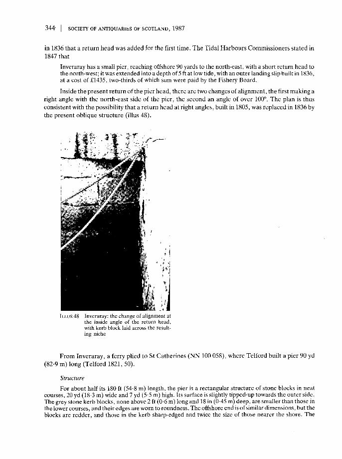
344' SOCIETY OF ANTIQUARIES OF SCOTLAND, 1987
in 1836 that a return head was added for the first time. The Tidal Harbours Commissioners stated in1847 that
Inveraray has a small pier, reaching offshore 90 yards to the north-east, with a short return head tothe north-west; it was extended into a depth of 5 ft at low tide, with an outer landing slip built in 1836,at a cost of £1435, two-thirds of which sum were paid by the Fishery Board.
Inside the present return of the pier head, there are two changes of alignment, the first making aright angle with the north-east side of the pier, the second an angle of over 100°. The plan is thusconsistent with the possibility that a return head at right angles, built in 1805, was replaced in 1836 bythe present oblique structure (illus 48).
ILLUS 48 Inveraray: the change of alignment atthe inside angle of the return head,with kerb block laid across the result-ing niche
From Inveraray, a ferry plied to St Catherines (NN 100 058), where Telford built a pier 90 yd(82-9 m) long (Telford 1821, 50).
StructureFor about half its 180 ft (54-8 m) length, the pier is a rectangular structure of stone blocks in neat
courses, 20 yd (18-3 m) wide and 7 yd (5-5 m) high. Its surface is slightly tipped-up towards the outer side.The grey stone kerb blocks, none above 2 ft (0-6 m) long and 18 in (0-45 m) deep, are smaller than those inthe lower courses, and their edges are worn to roundness. The offshore end is of similar dimensions, but theblocks are redder, and those in the kerb sharp-edged and twice the size of those nearer the shore. The

GRAHAM AND GORDON: OLD HARBOURS IN NORTHERN AND WESTERN SCOTLAND 345
return head projects obliquely westwards for 23 yd (21 m) and is 6 yd (5-5 m) wide. Beyond it, the pier headturns and descends, forming a slipway adjacent to its outer face. Two stone pawls are set back in niches inthis face to serve the slipway, an arrangement not seen elsewhere in the course of this study. There arethree flights of steps, two on the inner side, one at the foot of the slip. Near the shore, 14 steps, each madeof a single 3 ft (0-914 m) stone slab, with its (Roman) number cut in its surface, is inset in the pier face,descending seawards. Another 14 steps, only 2 ft (0-6 m) wide, are inset in the same face, descending nearto the angle of the return head. (This angle, as noted above, is a double one. The blocks in all the coursesexcept the kerb have been shaped so that the return head starts out at right angles to the pier before takingon its oblique alignment.) The third set of steps occupies nearly half the end of the slipway, which is 4Vi yd(4-1 m) broad where it ends at the foot of the outer face of the return head. The five steps are inset in theend of the slip, beside the face, so that the outer corner of the end of the slip has required to be secured byan iron strap 3 in (7-6 cm) wide embedded in a channel in the surface of the kerb blocks (see illus 55). Muchof this survives, whereas little of the rather similar iron strap-work on other parts of the pier is still to beseen.
APPENDIX 1
CAPSTANS, MOORING POSTS AND IRON FITTINGS OF PIERS (illus 49-56)
The harbours of Sarclet (p 299) and of East Loch Tarbert (p 339) were dependent for theirefficient operation, at the time of their building during the 19th-century herring fishing boom, onwhat was then called capstern apparatus. That of Tarbert, ensconced upon the Bidding (see p 340),warped the boats into shelter, while at Sarclet boats were warped up sloped pitching on to the curinggrounds. No doubt similar arrangements were quite common, though the capstans have disappeared.
ILLUS 49 Sarclet: the capstan 1843, from J Mitchell's plan (Herring Fisheries Commission 1846, 23, 20-1). Palland pall rack enabled the small figures at left to stop and start warping in safety (see also illus 21)

346 SOCIETY OF ANTIQUARIES OF SCOTLAND, 1987
ILLUS 50 Portmahomack: squat stone pawl,the set of six of which on the northpier (1816) much resemble stools
ILLUS 51 Inverness: uprooted stone pawl on Thornbush Quay.Length approximately 4'/2 ft (1-37 m). Date probably1817, about 60 years before the word 'bollard' cameinto use for moorings on shore
ILLUS 52 Inveraray: pawls in niches beside the slipway used by the ferry to StCatherines, which took carriages
ILLUS 53 Salen, Loch Sunart: hook 21 in (0-53 m) long, set innatural rock beside the pier

GRAHAM AND GORDON: OLD HARBOURS IN NORTHERN AND WESTERN SCOTLAND 347
But the apparatus for ordinary mooring of boats at the quayside usually consisted of what we now callbollards. The word bollard has, however, changed its meaning in the course of the 19th century. Fromits re-appearance, after a gap of centuries, in 1844 it was used exclusively of baulks of timber or metalfittings to which ropes could be secured on board ships. Hardy, in The Trumpet Major (1880), usedthe phrase, 'a bollard farther up the quay' (OED), and this usage has become current. Thus, themoorings described in this study were not contemporarily called bollards. Graham in earlier papersconsistently called them pawls. But as the primary meaning of pawl is the brake bar at the foot of acapstan, such as Mitchell illustrated so carefuly on his plan for Sarclet (illus 49), its continued use formooring posts in this paper calls for explanation. Graham's usage has been continued, firstly forconsistency, and secondly because of two indications, admittedly slight, that a more general meaning
ILLUS 54 Rockfield: kerb block loosened after rustingaway of run-bar
ILLUS 55 Inveraray: run-bar in channel, securing the end ofthe slipway and the top of its steps
ILLUS 56 Keills: run-bar and straps bolted to pier surfaces, without channels; those on the nearby slipway were set inchannels on the seaward sides only

348 | SOCIETY OF ANTIQUARIES OF SCOTLAND, 1987
may have been current at the material time. At Inverness, as early as 1729, five palls are marked onthe left bank of the river, and at Thurso a century later, pallage was being levied in an attempt to raisefunds for improving the harbour. In both cases there could have been capstans for warping ships intoposition in the rivers, but it does not seem very likely that the term pall would have taken over as thename for the whole apparatus. A maritime vernacular use of pall may be suggested as connecting it,on grounds of shape, with its meaning in Swedish, pall: a stool (illus 50). The root meaning, being thesame as that of the bole of a tree, could have given rise to a sense of 'pall' relating to a mooring pole orpost, which did not survive the introduction of the obviously expressive and popular word bollard(illus 51, 52).
Ropes and chains were caught and secured by hooks, loops and rings, the components of whichwere often 3 in (76 mm) or more in diameter (illus 53). Ferry piers are especially rich in such fittings.At Huna (p 310), there is no remaining pier, only a chain, the double links of which are 3 in (76 mm) indiameter.
The other main use of iron in harbour construction was for the cramps, straps and run-bars withwhich efforts were made to keep in place the blocks forming quay margins and parapet tops (illus 54).Even where these have rusted away, it is sometimes possible to see the channels in which they were set(illus 55). In other instances, it is the stone which has eroded, leaving the iron bar exposed. Where,however, sea wear was expected to be less, or where construction was less careful, the run-bars weresimply bolted to the surface (illus 56).
APPENDIX 2
ALPHABETICAL INDEX OF SITES
No Harbour1 Ackergill2 ALCAIC3 Alness Belle Point4 Alness Dalmore5 Alness Ferry6 Ardmaddy7 Ardmore8 Ardpatrick9 ARDRISHAIG
10 Armadale11 Aultbea12 AVOCH13 Balblair14 Balintore15 Balintraid16 Ballachulish17 Bettyhill
Bernera Glen Elg, see Lochalsh18 Berriedale19 BONAR BRIDGE20 Brims21 Broadhaven22 BRORA23 Brough24 CAMPBELTOWN25 CASTLEHILL
Page307 26 CHANONRY POINT 277279 27 Charlestown-on-Gairloch 327281 28 CONNEL FERRY 334281 29 Corran Ferry 333278 30 Clashcarnach 322335 31 Clyth 297286 32 Craignish 335337 33 Cregan Ferry 334340 34 Creich 287319 35 CRINAN 335326 36 CROMARTY 277275 37 Crosskirk (Forss) 317278 38 DALINTOBER 338282 39 DINGWALL 279282 40 Dornie 328333 41 DORNOCH FIRTH 284319 42 DORNOCH SHORE 288
43 DUNBEATH 293291 44 Dunrobin 290286 45 Durness 322317 46 Dwarwick 312307 47 Easdale 335289 48 Embo 288312 49 Ferryton 279337 Forss, see Crosskirk312 50 FORTROSE 276

GRAHAM AND GORDON: OLD HARBOURS IN NORTHERN AND WESTERN SCOTLAND 349
51525354555657585960616263646566676869707172737475767778798081828384858687888990919293949596
FORT WILLIAMFreswickFoulis FerryGartyGolspieGruinardHAMHeilamHELMSDALEHiltonHUNAInverINVERARAYInverbreckieINVERGORDONINVERNESSKeillsKeissKENTRAKESSOCKKilchoanKirtomyKylestrome-Kylesku FerryLaideLarochLatheronwheelLITTLE FERRY, SOUTH & NORTHLittle Loch BroomLOCHALINELoch AlshLoch CaolisportLoch CarronLOCH ERIBOLLLOCH ETIVELoch EweLoch FeochanLoch GairlochLOCH GILPHEADLOCHINVERLoch MelfortLoch TorridonLothLYBSTERMEIKLE FERRY NORTHMEIKLE FERRY SOUTHMelvich Bay
333308281291289326310320291283310285343282282269336307329275329319324326333294288326329327337327320334326334327342324335327290294287286318
979899
100101102103104105106107108109110111112113114115116117118119120121122123124125126127128129130131132133134135136137138139140141
MUNLOCHY BAYMurkleNewton PointNIGGOBANOccumsterPoolewePort AppinPortgowerPORTMAHOMACKPort nan ConPort OdharPortskerra (Portskerry)Port VasgoRISPONDRockfieldROSEMARKIESALENSANDSIDE BAYSARCLETScourieSCRABSTERShian FerryShoretonSkarfskerrySkerray BaySKIPNESSSkirzaSmooSound of SleatSouthendSTAXIGOEStrome FerryTAINTalmineTARBERT LOCH FYNETHURSOTongue FerryTONGUE, Kyle ofUdale BayULLAPOOLUnapoolUpper RoadsteadWhaligoeWICK
275314287282334297326333291284320322318319320283276329317299324316334279310319338308322328337307327286319339315319318278324324320297302
ACKNOWLEDGEMENTS
It was in the Map Room of the National Library of Scotland that the greater part of the fieldwork for the whole project concerning the old harbours of Scotland was planned by the late AngusGraham. The Staff there gave assistance, both in preparatory research, and interpretation of fielddata, with tireless skill and kindness, and have afforded the same to me. Staff of the Map Room in

350 SOCIETY OF ANTIQUARIES OF SCOTLAND, 1987
Cambridge University Library have helped me in the same way. The Scottish Record Office, andInverness Library and Museum staff have also been most helpful, and records at Dingwall were madeavailable while their arrangements for public viewing were still incomplete.
The Harbours at Inverness, Wick, Ullapool and Ardrishaig could not have been understoodwithout assistance from their Harbour Masters and Port Authorities. Access was kindly allowed tocertain restricted areas, and documentation was provided from harbour archives.
Many local residents gave information, among whom Mr and Mrs Charles Grant, Dornoch,were especially helpful, from their resources of oral history. Mrs George Cruden, Castlehill, havingpersonally worked in the rebuilding of that harbour, gave a first-hand account of the setting ofCaithness slabs on their narrow edges, which helped me to understand Bremner's invention.
In the field, I was helped by Paul C Hopkins at Whaligoe and Berriedale and by Mrs I Macleodat Occumster and Sarclet. Mrs Macleod provided much documentation for Sarclet, and kindly readand criticized the whole study.
I am most grateful to all who have helped me to complete the project begun by Angus Graham,30 years ago. (JG)
REFERENCES
AM 1792 Plan of Inverness, INVMG 244, Inverness Museum.APS Acts of the Parliaments of Scotland. 12 Vols, 1814-75. Edinburgh.Avery, J 1725-30 County maps for the Governor and Directors of the York Building Company. Map of
the inner Moray Firth, Inverness Public Library.BFS 1848 Report to the Governor, Deputy Governor and Director of the British Fisheries Society on
their estate at Pulteneytown. Edinburgh.Brand, J 1701 A brief description of Orkney, Zetland, Pightland Firth and Caithness. Edinburgh
(reprint 1883).Bremner, J 1845 Treatise on the planning and building of harbours. Wick.Broad, H 1981 Rails to Ayr: 18th and 19th century waggonways. [=Ayrshire Collections, 12/6, Ayrshire
Archaeol Natur Hist Soc.]Brown, P H 1893 Scotland before 1700 from contemporary documents. Edinburgh.Calder, J T 1887 History of Caithness. Thurso (reprint 1971).Caledonian Canal Commission. Eighteenth Report by the Commissioners for the Caledonian Canal, 10
(1821).Cameron, A D 1975 'Communications (d) Water', in The hub of the Highlands. Inverness Field Club,
centenary vol. Edinburgh.Cameron, G 1847 History and description of the town of Inverness.Campbell, Mrs, of Skipness 1813-14 Diaries.Carruthers, R 1967 Old Inverness: A collection of prints. Inverness.Cockburn, H 1888 Circuit journeys 1837-1854. Edinburgh (reprint 1983).Collins, G 1689 Great Britain's coasting pilot. London (edn of 1776).Dunlop, J 1952 The British Fisheries Society. Unpub thesis, Univ Edinburgh.Fraser, J 1910 'Cromwell's Citadel and the harbour of Inverness', Trans Inverness Sci Soc Fid Club, 6
(1899-1906), 93-102.Gibb, A 1935 The story of Telford. London.Gibson, JS 1967 Ships of the '45. London.Graham, A 1968 'Old harbours of Dunbar', Proc Soc Antiq Scot, 99 (1966-7), 173-90.Graham, A 1969 'Archaeological notes on some harbours in eastern Scotland', Proc Soc Antiq Scot,
101 (1968-9), 200-85.Graham, A 1979a 'Old harbours and landing places on the east coast of Scotland', Proc Soc Antiq Scot,
108 (1976-7), 322-66.Graham, A 1979b 'Some old harbours in Wigtownshire', Trans Dumfriesshire Galloway Natur Hist
Antiq Soc, 3 ser, 54 (1979), 39-74.
GRAHAM AND GORDON: OLD HARBOURS IN NORTHERN AND WESTERN SCOTLAND | 351
Graham, A 1984 Old Ayrshire harbours. [=Ayrshire Collections, 14/3, Ayrshire Archaeol Natur HistSoc.]
Graham, A & Truckell A E 1977 'Old harbours of the Solway Firth', Trans Dumfriesshire GallowayNatur HistAntiq Soc, 3 ser, 52 (1976-7), 109^2.
Groome,FH 1901 Ordnance Gazeteer of Scotland. Edinburgh.Haldane, A R E 1952 The drove roads of Scotland. London.Harbours 1847 Parliamentary Commission on Tidal Harbours. Second report of the Commissioners in
Reports, Commissioners, 32. London.Henderson, J 1812a General view of the agriculture of the county of Caithness. London.Henderson, J 1812b General view of the agriculture of the county of Sutherland. London.Henderson,! 1884 Notes on Caithness family history. Edinburgh.Herring Fishery Commission. Reports by the Commissioners for the Herring Fisheries. For 1828, 15
(1830); 1833, 36 (1835); 1843, 23 (1846).Highland Roads and Bridges Commission 1821 Ninth Report by the Commissioners for Highland
Roads and Bridges, 1816-21, 10 (1821).Hume, J 1774 'Plan of the river Ness etc: Judicial plan for the cause of the teuars of Inverness, decided
1776', Trans Inverness Sci Soc Fid Club, 2 (1883).Inverness Field Club 1978 Old Inverness in pictures. Edinburgh.Jamieson, J 1818 Etymological dictionary of the Scottish language. Edinburgh.Leslie 1846 Plan of Inverness. Inverness Museum.Leslie, Bishop 1578 Deoriginis, moribus et rebus Scotorum, wBrown,PH, 1893, Scotland before 1700.
Edinburgh.Lindsay, I & Cosh, M 1973 Inveraray and the Dukes of Argyll. Edinburgh.Macfarlane Geog Coll Geographical Collections relating to Scotland made by Walter Macfarlane,
Mitchell, A (ed), 3V, 1906-8. [=Scot Hist Soc, 51-3].Macrae, N 1923 The romance of 'a Royal Burgh. Dingwall.Marwick, J D (ed) 1866-90 Records of the Convention of the Royal Burghs of Scotland, 6V. Edinburgh.Matthew Paris Chronica majora. Rolls edn.Ministry of Transport; RHP 1843 t̂ Plan of Inverness. Edinburgh.Mitchell, J 1883 Reminiscences of my life in the Highlands. Edinburgh (1971 reprint).Mitchison, R 1962 Agricultural Sir John. London.Mowat, J 1938 Old Caithness maps and mapmakers. Wick.Mowat, J 1980 James Bremner, wreck-raiser. Thurso (reprint).Mowat, WG 1936 'Chronicle of Wick harbour', inJohn O'Groats Journal centenary supplement, 7Feb
1936. Wick.Mowat, W G 1938 The story of Lybster. Wick.NSAS New Statistical Account of Scotland, 1845, Edinburgh.Parliamentary Accounts and Papers (Blue Books), see Caledonian Canal; Harbours: Herring Fishery;
Highland Roads and Bridges.PCFC 1869 Proc Caithness Fid Club (1869), Report of a visit to Papigoe and Staxigoe.Pennant, T 1979 A tour of Scotland in 1769. (Reprint 1979, Warrington.)RHP Register House Plans Series, West Register House, Edinburgh.Ross, A 1883 'Old Inverness', Trans Inverness Sci Soc Fid Club, 2 (1883).Roy, W 1747-55 Military survey of the Highlands of Scotland, MS British Library map library, xlviii,
25-lbc.RCAMS 1971 Royal Commission on the Ancient and Historical Monuments of Scotland. An Inventory
of the Ancient Monuments, Argyll 1: Kintyre. Edinburgh.RCAMS 1975 An Inventory of the Ancient Monuments, Argyll 2: Lorn. Edinburgh.Sinclair, J 1802 Essays on miscellaneous subjects. London.Slezer, J 1693 Theatrum Scotiae. London .SAS The Statistical Account of Scotland, Sinclair, Sir J (ed), 1792-7. Edinburgh.Sutherland, I 1982 Wick harbour and the herring fishing. Wick.Tacitus: Cornelii Taciti, De vitae Agricolae, Ogilvie, R M & Richardson, I (eds), 1967. Oxford.Taylor, G & Skinner, A 1776 Survey and maps of the roads of North Britain or Scotland. London.Telford, T 1821 Appendix to ninth Report of the Commissioners for Highland roads and bridges.
Accounts and Papers, 10 (1821). London.

352 SOCIETY OF ANTIQUARIES OF SCOTLAND, 1987
Telford, T 1838 Life of Thomas Telford, Civil Engineer (with atlas), Rickman J (ed). London.Washington, J 1848 Lybster harbour, Caithness. Extract from next entry.Washington, J 1849 Captain Washington's Report on the loss of life and damage caused to fishing boats
by the gale of 19th August 1848. Accounts and Papers, 22, 51 (1849), London.Waters, F Thurso then and now. Thurso.Waters, F The story of Thurso. Thurso.Wood, J 1821 Town Atlas. Edinburgh.Wordsworth,! 1982 'Excavations at Castle Street, Inverness', Proc Soc Antiq Scot, 112 (1982), 322-91.