OKLAHOMA DEPARTMENT OF TRANSPORTATION … responsible individuals at each phase of development and...
83
OKLAHOMA DEPARTMENT OF TRANSPORTATION PROJECT DEVELOPMENT PROCESS 2015
Transcript of OKLAHOMA DEPARTMENT OF TRANSPORTATION … responsible individuals at each phase of development and...

OKLAHOMA DEPARTMENT OF TRANSPORTATION
PROJECT DEVELOPMENT PROCESS
2015

TABLE OF CONTENTS
SECTION 1 FOREWORD
SECTION 2 PROJECT DEVELOPMENT PROCESS DESCRIPTION OF ACTIVITIES FOR PROJECT DEVELOPMENT SCHEDULE (EXAMPLES)
SECTION 3 ON SYSTEM INTRODUCTION – ON SYSTEM PROJECTS PROCESS INSTRUCTIONS FOR PROJECT INITIATION MEETING PROJECT INITIATION GUIDELINES PROJECT INITIATION REPORT (EXAMPLE) PROCESS INSTRUCTIONS FOR PLAN DEVELOPMENT MEETINGS PRELIMINARY PLAN FIELD REVIEW MEETING GUIDELINES RIGHT-OF-WAY AND UTILITY MEETING GUIDELINES FINAL PLAN FIELD REVIEW MEETING GUIDELINES PROCESS INSTRUCTIONS FOR PS&E PACKAGE SECTION 4 OFF SYSTEM INTRODUCTION – OFF SYSTEM PROJECTS PROCESS INSTRUCTIONS FOR PLAN DEVELOPMENT MEETINGS PLAN-IN-HAND FIELD REVIEW MEETING GUIDELINES FINAL PLAN FIELD REVIEW MEETING GUIDELINES
APPENDIX ON SYSTEM PROJECT RECONNAISSANCE DATA COLLECTION LIST PROJECT INITIATION REPORT PLAN SET DISTRIBUTION PROJECT SUBMISSION TO RIGHT-OF-WAY INSTRUCTIONS FOR COMPLETING SEC. 404 PERMIT APPLICATION TRAFFIC ENGINEERING SUBMISSIONS PROJECT SUBMISSION LETTER FEDERAL AID PROJECT AUTHORIZATION DOCUMENTATION LIST REQUIRED MEETINGS FOR THE LETTING PROCESS REVISION DISTRIBUTED BY DEPARTMENT OFF SYSTEM REQUEST FOR CIRB PROGRAM PROJECT CONSIDERATION
LOCAL GOVERNMENT NEPA CHECKLIST REGULATORY PROVISIONS CHECKLIST FOR NON FHWA PROJECTS REGULATORY COMPLIANCE RESOLUTION (NON FEDERAL FUNDS) PROJECT SUBMISSION TO RIGHT-OF-WAY
i

FOREWORD History: The 2001 Project Development Process was created with a goal to
maximize productivity and streamline plan development. Modifications to the Plan Development Process were implemented to establish the needed meetings and the minimum project progress required to have a successful review.
With the progression of time, the requirements, deliverables and
activities included in the work break down schedule have evolved, therefore requiring that these changes be documented resulting in an update to the original Project Development Process.
Responsible Party: The responsibility for strict adherence to the requirements for the
meetings continues to lie with each Division, as outlined in the packet. The schedules for each project will be created by the Project Manager which will include the dates for the project meetings. Tools under development will allow access for each Division to view, edit and update project status information and utilize resource leveling data. In addition a central filing system is available for the filing of final project documentation.
Modifications: The 2014 updates to the Project Development Process include the
plan delivery requirements for meetings and submissions to ODOT, along with a revised section on the Description of the Activities for Project Development Process.
Meeting Location: The anticipated locations of the meetings are reported in the
packets and do not represent a change from procedures established in the original 2001 Project Development Process.
The Future: It is not possible to create a single project development and
implementation process that will prove effective for every project every time. We must recognize that the expertise and judgment of the responsible individuals at each phase of development and implementation cannot be minimized or replaced.
The Departments Project Development Process must be one of
continuous improvement. We will continue to strive to improve the process to insure successful project delivery.
1

PROJECT DEVELOPMENT PROCESS
Project management methodologies shall be used for development of every construction project in the Eight Year Construction Work Plan. The Project Management Division shall establish and maintain meaningful project schedules, establish accountability for project components, manage the construction program and measure performance. The Project Manager shall establish a milestone based project schedule for each project identified in the Eight Year Construction Work Plan. Each schedule shall be specific to the projects and the milestones shall be set considering the requirements of the components associated with each of the specific projects in accordance with the development phases as outlined in the project schedules. The Project Management Division shall facilitate any necessary modifications to the scope, schedule and/or budgets of approved Eight Year Construction Work Plan projects through a formal revision process. Validation of projects shall be accomplished through drive outs and/or other project team meetings with the complete participation of appropriate Engineering and Operations Divisions as deemed necessary. The responsible Project Manager shall schedule, coordinate and facilitate these meetings.
2
DESCRIPTION OF THE ACTIVITIES FOR PROJECT DEVELOPMENT 1 Initiation Phase 1.1 Reconnaissance Report
Pertinent information is gathered to assist in the completion of the Project Initiation.
1.2 Project Initiation Meeting
A multi - divisional activity that evaluates a project and determines if the mental image of the design is consistent with the available funds and this activity results in a final initiation report document.
1.3 Project Initiation Report
A comprehensive report that documents the scope of the project. 2 Contracting Phase 1.4 Solicitation
Once ODOT has determined that work shall be contracted to outside parties, a notice is sent out so that those interested may respond. These responses are compiled into a list that is used for the selection process.
1.5 Selection
The process by which qualified consultants are selected by an ODOT selection committee to work under contract to complete the requested services represented in the solicitation.
1.6 Contract Development
The development and execution of a contract that identifies the scope and fee as negotiated with the selected consultant.
3

3 Preliminary Project Development Phase 3.1 NEPA 3.1.1 Conduct Environmental Studies
Studies are conducted to evaluate the impact of a project on the environment and the community.
3.1.2 Finalize Environmental Document
The studies and any necessary comments are included in a final document which is then presented to the Federal Highway Administration for approval.
3.2 Survey
A project survey is initiated in order to provide criteria, topography, digital terrain models, utilities and other information, according to original scope, that is necessary for project design.
3.3 Bridge Hydraulics
The Hydraulics Engineer completes studies on the location to ensure that the right size structure (bridge or culvert) is built. After the studies are complete, they give the designers the type of bridge or culvert that is required.
3.4 Preliminary Plan Field Review Meeting
A multi-divisional activity that presents a preliminary proposal and provides for a site visit to visually check for compatibility and completeness. Information from survey and recommendations from the hydraulic conference are used to aid in establishing the vertical and horizontal alignments. The preliminary design is evaluated to determine that the objectives are consistent with the proposed scope for the project.
3.5 Right-of-Way & Utility Meeting
A multi-divisional activity that evaluates right-of-way specific issues prior to the submission of design plans to Right-of-Way Division.
3.6 Right-of-Way Submission
Provide design plans outlining the proposed right-of-way take to the Right-of-Way Division.
4

4 Final Project Development Phase 4.1 Pedological Survey
Geotechnical Investigations are completed to aid in the design of the pavement and determine slope stability requirements.
4.2 Bridge Soundings
Geotechnical Investigations are completed to aid in the design of the Bridge structure.
4.3, 4.4, 4.5 Roadway, Bridge, and Traffic Final Plans
Plans are developed to a stage that will allow for a Final Plan Field Review Meeting to be held.
4.6 Final Plan Field Review Meeting
A multi - divisional activity that presents a design and provides for a site visit if necessary to visually check for completeness. This meeting is held to review the near completed plans to verify that all design elements are included and that the necessary pay items and notes are in the plans. The Final Pavement Design is to be incorporated in the plans and any phase construction is to be addressed in the earthwork quantities and cross-sections.
4.7 Land Acquisition
The purchase of property rights deemed necessary for the construction and maintenance of a proposed transportation project. Activities included may be cost estimating, funding/programming, plan review, contracting, title investigation, mapping, appraisal and appraisal review, negotiation, plan revision, condemnation, residential and commercial relocation.
4.7.2 Abatement & Demolition
Abatement includes NESHAP Inspection and, when necessary, Abatement Planning and Abatement Implementation, generally removal of asbestos insulation and/or siding. Other activities that may be included are removal of underground storage tanks, remediation of contaminated soil and mitigation of other hazardous substances. Demolition includes the removal of structures or other improvements from the proposed Right-of-Way.
5

4.7.3 Conduct Utility Relocation
Completed survey information and construction plans are utilized to identify utility details and current ownerships. On-site meetings are held with each utility to address proposals and agreements. Upon agreement, utilities are moved with ODOT oversight.
4.8 PS&E Assembly
The assembly of Plans, Specifications and Estimates from each Division contributing to the plan development in preparation for the official submission to the Office Engineer.
4.9 PS&E to Office Engineer
The submission of Final Plans, Specifications and Estimates to Office Engineer. This submission also includes any project specific permits or agreements such as 404 Permits, Railroad Agreements, etc.
4.9.1 Place on Shelf
The complete package for submission may be placed on the shelf if completed earlier than the planned letting date. The schedule templates used for most projects facilitate a 2 year shelf period.
4.9.2 Conduct Re-Evaluation
A process to ensure that a previously approved NEPA Document is up to date. 5 Letting Phase 5.1 PS&E Authorization
The process of assembling project information in preparation for approval for funding authorization by FHWA.
5.2 Let Project
The Office Engineer produces a contract package and publishes the formal advertisement to solicit bids from interested contractors. The bids are opened at a formal meeting conducted by ODOT.
6

5.3 Award Project
The bids are evaluated and a recommendation for contract award is made to the Oklahoma State Transportation Commission. Upon Commission approval and concurrence by Federal Highway Administration, the PS&E package is submitted to ODOT Construction Division for issuance of the work order.
5.4 Commission Approval
The Oklahoma State Transportation Commission approves the project for construction . ODOT Construction Division will then set the date for construction to begin.
7

ID Step WBS Task Name Duration Float Start Finish Predecessors Successors Constraint Type1 1 Initiation Phase 145 days 0 days Fri 9/10/10 Thu 3/31/11 As Late As Possible2 1.1 Reconnaissance Report 85 days 0 days Fri 9/10/10 Thu 1/6/11 As Late As Possible3 1.1.1 Request Recon Data 5 days 0 days Fri 9/10/10 Thu 9/16/10 4 As Late As Possible4 1.1.2 Collect Recon Data 60 days 0 days Fri 9/17/10 Thu 12/9/10 3 5 As Late As Possible5 1.1.3 Review Recon Data 10 days 0 days Fri 12/10/10 Thu 12/23/10 4 6 As Late As Possible6 1 1.1.4 Finalize Recon Report 10 days 0 days Fri 12/24/10 Thu 1/6/11 5 8 As Late As Possible7 1.2 Project Initiation Meeting 20 days 0 days Fri 1/7/11 Thu 2/3/11 As Late As Possible8 1.2.1 Schedule Project Initiation Meeting 19 days 0 days Fri 1/7/11 Wed 2/2/11 6 9 As Late As Possible9 2 1.2.2 Conduct Project Initiation Drive Out 1 day 0 days Thu 2/3/11 Thu 2/3/11 8 11 As Late As Possible
10 1.3 Project Initiation Report 40 days 0 days Fri 2/4/11 Thu 3/31/11 As Late As Possible11 1.3.1 Prepare Aerial with Limits of Right-of-Way 20 days 0 days Fri 2/4/11 Thu 3/3/11 9 12 As Late As Possible12 3 1.3.2 Finalize Project Initiation Report 20 days 0 days Fri 3/4/11 Thu 3/31/11 11 15,41 As Late As Possible13 2 Contracting Phase 154 days 0 days Fri 4/1/11 Wed 11/2/11 As Late As Possible14 2.1 Solicitation 34 days 0 days Fri 4/1/11 Wed 5/18/11 As Late As Possible15 2.1.1 Draft Solicitation Sent for Review 10 days 0 days Fri 4/1/11 Thu 4/14/11 12 16,20 As Late As Possible16 2.1.2 Post Solicitation 1 day 0 days Fri 4/15/11 Fri 4/15/11 15 17 As Late As Possible17 2.1.3 Receive Letters of Interest 15 days 0 days Mon 4/18/11 Fri 5/6/11 16 18 As Late As Possible18 4 2.1.4 Post Letters of Interest 8 days 0 days Mon 5/9/11 Wed 5/18/11 17 21 As Late As Possible19 2.2 Selection 36 days 0 days Thu 5/5/11 Thu 6/23/11 As Late As Possible20 2.2.1 Seat DCSC 10 days 14 days Thu 5/5/11 Wed 5/18/11 15 21 As Late As Possible21 2.2.2 Develop Shortlist 10 days 0 days Thu 5/19/11 Wed 6/1/11 18,20 22 As Late As Possible22 2.2.3 Obtain Shortlist Approval 3 days 0 days Thu 6/2/11 Mon 6/6/11 21 23 As Late As Possible23 2.2.4 Conduct Interviews 10 days 0 days Tue 6/7/11 Mon 6/20/11 22 24 As Late As Possible24 5 2.2.5 Obtain Selection Approval 3 days 0 days Tue 6/21/11 Thu 6/23/11 23 26 As Late As Possible25 2.3 Contract Development 94 days 0 days Fri 6/24/11 Wed 11/2/11 As Late As Possible26 2.3.1 Conduct Pre-negotiation Meeting 10 days 0 days Fri 6/24/11 Thu 7/7/11 24 27 As Late As Possible27 2.3.2 Conduct Negotiation Meeting 5 days 0 days Fri 7/8/11 Thu 7/14/11 26 28 As Late As Possible28 2.3.3 Receive Final Scope and Fee from Consultant 7 days 0 days Fri 7/15/11 Mon 7/25/11 27 29,30 As Late As Possible29 2.3.4 Submit Agenda Item 1 day 0 days Tue 7/26/11 Tue 7/26/11 28 31 As Late As Possible30 2.3.5 Finalize Contract Document 10 days 26 days Wed 8/31/11 Tue 9/13/11 28 32 As Late As Possible31 2.3.6 Receive Commission Approval 35 days 0 days Wed 7/27/11 Tue 9/13/11 29 32 As Late As Possible32 2.3.7 Consultant - Execute Contract 10 days 0 days Wed 9/14/11 Tue 9/27/11 30,31 33 As Late As Possible33 2.3.8 Department - Execute Contract 5 days 0 days Wed 9/28/11 Tue 10/4/11 32 34 As Late As Possible34 2.3.9 FHWA - Execute Contract 5 days 0 days Wed 10/5/11 Tue 10/11/11 33 35 As Late As Possible35 2.3.10 Receive Federal Authorization 5 days 0 days Wed 10/12/11 Tue 10/18/11 34 36 As Late As Possible36 2.3.11 Encumber Funds 10 days 0 days Wed 10/19/11 Tue 11/1/11 35 37 As Late As Possible37 6 2.3.12 Issue Notice to Proceed 1 day 0 days Wed 11/2/11 Wed 11/2/11 36 46,87 As Late As Possible38 3 Preliminary Project Development Phase 421 days 0 days Thu 11/3/11 Thu 6/13/13 As Late As Possible39 3.1 NEPA (CE3) 201 days 0 days Fri 8/31/12 Fri 6/7/13 As Late As Possible40 3.1.1 Conduct Environmental Studies 161 days 257 days Fri 8/31/12 Mon 4/15/13 As Late As Possible41 3.1.1.1 Receive Final Initiation Report & Construction Limit 1 day 370 days Fri 8/31/12 Fri 8/31/12 12 42 As Late As Possible42 3.1.1.2 Review Initiation Report & Establish Study Footprint 10 days 370 days Mon 9/3/12 Fri 9/14/12 41 43 As Late As Possible43 3.1.1.3 Coordinate With FHWA As Required 8 days 370 days Mon 9/17/12 Wed 9/26/12 42 44 As Late As Possible44 3.1.1.4 Prepare Request For Task Order Services 0 days 370 days Thu 9/27/12 Thu 9/27/12 43 45 As Late As Possible45 3.1.1.5 Negotiate Consultant Cost Proposal 0 days 370 days Thu 9/27/12 Thu 9/27/12 44 46 As Late As Possible46 3.1.1.6 Issue Environmental Notice To Proceed 0 days 235 days Thu 9/27/12 Thu 9/27/12 45,37 47 As Late As Possible47 3.1.1.7 Plot Study Footprint 10 days 235 days Thu 9/27/12 Wed 10/10/12 46 48,49,51,56,62 As Late As Possible48 3.1.1.8 Notify Property Owners 5 days 235 days Thu 10/11/12 Wed 10/17/12 47 52,53,54,55 As Late As Possible49 3.1.1.9 Cultural Resources & Tribal Coordination Initiation 0 days 240 days Thu 10/18/12 Thu 10/18/12 47 50 As Late As Possible50 3.1.1.10 Tribal Coord 30 Day Period Prior To Start Of Studies 0 days 240 days Thu 10/18/12 Thu 10/18/12 49 52,53,54,55 As Late As Possible51 3.1.1.11 Prepare Solicitation Letters 40 days 281 days Fri 12/14/12 Thu 2/7/13 47 67 As Late As Possible52 3.1.1.12 Conduct Cultural Resources Study 70 days 235 days Thu 10/18/12 Wed 1/23/13 48,50 57 As Late As Possible53 3.1.1.13 Conduct T&E And Wetland Studies 70 days 235 days Thu 10/18/12 Wed 1/23/13 48,50 57 As Late As Possible54 3.1.1.14 Conduct Hazardous Waste Studies 70 days 235 days Thu 10/18/12 Wed 1/23/13 48,50 57,71 As Late As Possible55 3.1.1.15 Conduct Noise Studies 70 days 235 days Thu 10/18/12 Wed 1/23/13 48,50 57,58,71 As Late As Possible56 3.1.1.16 Coordinate With NRCS 35 days 332 days Mon 2/25/13 Fri 4/12/13 47 72 As Late As Possible57 3.1.1.17 ODOT review of Specialist Studies 0 days 235 days Thu 1/24/13 Thu 1/24/13 52,53,54,55 59,60,61,65 As Late As Possible58 3.1.1.18 Review Noise Study 0 days 235 days Thu 1/24/13 Thu 1/24/13 55 65 As Late As Possible
2013.06.10 - 2016 Project Development Schedule Template.mpp
Wed 6/26/13
8
ID Step WBS Task Name Duration Float Start Finish Predecessors Successors Constraint Type59 3.1.1.19 Coordinate With USFWS 35 days 257 days Mon 2/25/13 Fri 4/12/13 57 71 As Late As Possible60 3.1.1.20 Coordinate With SHPO 35 days 257 days Mon 2/25/13 Fri 4/12/13 57 71 As Late As Possible61 3.1.1.21 SHPO For Historic Bridges 0 days 292 days Mon 4/15/13 Mon 4/15/13 57 71 As Late As Possible62 3.1.1.22 Coordinate Initial Section 4(f) De minimis 0 days 320 days Thu 2/7/13 Thu 2/7/13 47 63 As Late As Possible63 3.1.1.23 Issue Public Notice For Section 4(f) De minimis 0 days 320 days Thu 2/7/13 Thu 2/7/13 62 71,66 As Late As Possible64 3.1.2 Finalize Environmentall Document 97 days 0 days Thu 1/24/13 Fri 6/7/13 As Late As Possible65 3.1.2.1 Prepare For Initial Public Mtg After Specialist Studies 10 days 235 days Thu 1/24/13 Wed 2/6/13 57,58 66 As Late As Possible66 3.1.2.2 Conduct Pre Meeting 1 day 235 days Thu 2/7/13 Thu 2/7/13 65,63 67 As Late As Possible67 3.1.2.3 Prepare Public Meeting Notifications 15 days 235 days Fri 2/8/13 Thu 2/28/13 66,51 68 As Late As Possible68 3.1.2.4 Conduct Public Meeting 1 day 235 days Fri 3/1/13 Fri 3/1/13 67 69 As Late As Possible69 3.1.2.5 End Public Comment Period 20 days 235 days Mon 3/4/13 Fri 3/29/13 68 70 As Late As Possible70 3.1.2.6 Respond To Public Comments 10 days 235 days Mon 4/1/13 Fri 4/12/13 69 71 As Late As Possible71 3.1.2.7 Select Preferred Alternative 0 days 235 days Mon 4/15/13 Mon 4/15/13 54,55,59,60,61,63,70 72 As Late As Possible72 3.1.2.8 Prepare Draft EA 10 days 0 days Mon 4/15/13 Fri 4/26/13 71,56,107 73 As Late As Possible73 3.1.2.9 FHWA/EPD Review Draft EA 20 days 0 days Mon 4/29/13 Fri 5/24/13 72 74 As Late As Possible74 3.1.2.10 Prepare Revised EA 0 days 0 days Mon 5/27/13 Mon 5/27/13 73 75,76 As Late As Possible75 3.1.2.11 FHWA Approve EA 0 days 0 days Mon 5/27/13 Mon 5/27/13 74 77 As Late As Possible76 3.1.2.12 Prepare for Initial Public Hearing 0 days 0 days Mon 5/27/13 Mon 5/27/13 74 77 As Late As Possible77 3.1.2.13 Conduct Pre Meeting 0 days 0 days Mon 5/27/13 Mon 5/27/13 75,76 78 As Late As Possible78 3.1.2.14 Prepare Public Hearing Notifications 0 days 0 days Mon 5/27/13 Mon 5/27/13 77 79 As Late As Possible79 3.1.2.15 Conduct Public Meeting 0 days 0 days Mon 5/27/13 Mon 5/27/13 78 80 As Late As Possible80 3.1.2.16 End Public Comment Period 0 days 0 days Mon 5/27/13 Mon 5/27/13 79 81 As Late As Possible81 3.1.2.17 Respond To Public Comments 0 days 0 days Mon 5/27/13 Mon 5/27/13 80 82 As Late As Possible82 3.1.2.18 Prepare Revised EA 0 days 0 days Mon 5/27/13 Mon 5/27/13 81 83 As Late As Possible83 3.1.2.19 FHWA/EPD Review Revised EA 0 days 0 days Mon 5/27/13 Mon 5/27/13 82 84 As Late As Possible84 3.1.2.20 FHWA Prepare FONSI 0 days 0 days Mon 5/27/13 Mon 5/27/13 83 85 As Late As Possible85 3.1.2.21 Distribute FONSI 10 days 0 days Mon 5/27/13 Fri 6/7/13 84 109,149,145 As Late As Possible86 3.2 Survey 60 days 0 days Thu 11/3/11 Wed 1/25/12 As Late As Possible87 3.2.1 Determine the Survey Type and Extents 2 days 0 days Thu 11/3/11 Fri 11/4/11 37 88 As Late As Possible88 3.2.2 Perform Survey 56 days 0 days Mon 11/7/11 Mon 1/23/12 87 89 As Late As Possible89 7 3.2.3 Archive Survey 2 days 0 days Tue 1/24/12 Wed 1/25/12 88 95 As Late As Possible90 3.3 Bridge Hydraulics 30 days 0 days Fri 3/16/12 Thu 4/26/12 As Late As Possible91 3.3.1 Perform Hydraulics 15 days 0 days Fri 3/16/12 Thu 4/5/12 95 92 As Late As Possible92 3.3.2 Conduct Bridge Hydraulic Conference 1 day 0 days Fri 4/6/12 Fri 4/6/12 91 93 As Late As Possible93 8 3.3.3 Finalize Hydraulic Report 14 days 0 days Mon 4/9/12 Thu 4/26/12 92 96 As Late As Possible94 3.4 Preliminary Plan Field Review Meeting 147 days 0 days Thu 1/26/12 Fri 8/17/12 As Late As Possible95 3.4.1 Plot Plan & Profile 36 days 0 days Thu 1/26/12 Thu 3/15/12 89 91 As Late As Possible96 3.4.2 Set Minimum Bridge Elevation 3 days 0 days Fri 4/27/12 Tue 5/1/12 93 97 As Late As Possible97 3.4.3 Set Finished Grade 8 days 0 days Wed 5/2/12 Fri 5/11/12 96 99,98,112 As Late As Possible98 3.4.4 Prepare Roadway Preliminary Plans 50 days 0 days Mon 5/14/12 Fri 7/20/12 97 100 As Late As Possible99 3.4.5 Prepare Bridge Preliminary Plans 20 days 30 days Mon 6/25/12 Fri 7/20/12 97 100 As Late As Possible
100 9 3.4.6 Perform Preliminary Plan Field Review Meeting 20 days 0 days Mon 7/23/12 Fri 8/17/12 98,99 102,121,125,115,144,145 As Late As Possible101 3.5 Right-of-Way & Utility Meeting 124 days 0 days Mon 8/20/12 Thu 2/7/13 As Late As Possible102 3.5.1 Establish Proposed Right-of-Way 104 days 0 days Mon 8/20/12 Thu 1/10/13 100 103 As Late As Possible103 10 3.5.2 Conduct Right-of-Way & Utility Meeting 20 days 0 days Fri 1/11/13 Thu 2/7/13 102 106,105 As Late As Possible104 3.6 Right-of-Way Submission 90 days 0 days Fri 2/8/13 Thu 6/13/13 As Late As Possible105 3.6.1 RW Meeting Plan Revisions 45 days 0 days Fri 2/8/13 Thu 4/11/13 103 107 As Late As Possible106 3.6.2 Prepare Project Agreement 20 days 25 days Fri 3/15/13 Thu 4/11/13 103 107 As Late As Possible107 3.6.3 Submit Construction Plans for Right-of-Way 1 day 0 days Fri 4/12/13 Fri 4/12/13 106,105 119,72,108 As Late As Possible108 3.6.4 Perform Right-of-Way Cost Estimating 20 days 20 days Mon 5/13/13 Fri 6/7/13 107 109 As Late As Possible109 11 3.6.5 Authorize Right-of-Way and Utility Funding 4 days 0 days Mon 6/10/13 Thu 6/13/13 85,108 132,133 As Late As Possible110 4 Final Project Develoment Phase 701 days 0 days Fri 6/14/13 Fri 2/19/16 As Late As Possible111 4.1 Pedological Survey 77 days 357 days Wed 9/25/13 Thu 1/9/14 As Late As Possible112 4.1.1 Prepare Pedological Request & Notice 2 days 357 days Wed 9/25/13 Thu 9/26/13 97 113 As Late As Possible113 12 4.1.2 Perform Pedological Survey 75 days 357 days Fri 9/27/13 Thu 1/9/14 112 118 As Late As Possible114 4.2 Bridge Soundings 80 days 404 days Fri 3/7/14 Thu 6/26/14 As Late As Possible115 4.2.1 Generate Bridge Sounding Requirements 5 days 404 days Fri 3/7/14 Thu 3/13/14 100 116 As Late As Possible116 13 4.2.2 Perform Bridge Soundings 75 days 404 days Fri 3/14/14 Thu 6/26/14 115 122 As Late As Possible
2013.06.10 - 2016 Project Development Schedule Template.mpp
Wed 6/26/13
9

ID Step WBS Task Name Duration Float Start Finish Predecessors Successors Constraint Type117 4.3 Roadway Final Plans 165 days 214 days Fri 1/10/14 Thu 8/28/14 As Late As Possible118 4.3.1 Design Pavement 20 days 357 days Fri 1/10/14 Thu 2/6/14 113 119 As Late As Possible119 14 4.3.2 Prepare Roadway Final Plans 145 days 214 days Fri 2/7/14 Thu 8/28/14 107,118 128 As Late As Possible120 4.4 Bridge Final Plans 60 days 404 days Fri 6/6/14 Thu 8/28/14 As Late As Possible121 4.4.1 Prepare Bridge Structural Design 30 days 469 days Fri 6/6/14 Thu 7/17/14 100 123 As Late As Possible122 4.4.2 Design Bridge Foundation 15 days 404 days Fri 6/27/14 Thu 7/17/14 116 123 As Late As Possible123 15 4.4.3 Prepare Bridge Final Plans 30 days 404 days Fri 7/18/14 Thu 8/28/14 121,122 128 As Late As Possible124 4.5 Traffic Final Plans 132 days 397 days Wed 2/26/14 Thu 8/28/14 As Late As Possible125 4.5.1 Prepare Traffic Division Request 2 days 397 days Wed 2/26/14 Thu 2/27/14 100 126 As Late As Possible126 16 4.5.2 Prepare Traffic Final Plans 130 days 397 days Fri 2/28/14 Thu 8/28/14 125 128 As Late As Possible127 4.6 Final Plan Field Review Meeting 20 days 214 days Fri 8/29/14 Thu 9/25/14 As Late As Possible128 4.6.1 Schedule Final Plan Field Review Meeting 19 days 214 days Fri 8/29/14 Wed 9/24/14 119,123,126 129 As Late As Possible129 17 4.6.2 Conduct Final Plan Field Review Meeting 1 day 214 days Thu 9/25/14 Thu 9/25/14 128 141,142,143 As Late As Possible130 4.7 Land Acquisition 365 days 0 days Fri 6/14/13 Thu 11/6/14 As Late As Possible131 4.7.1 Obtain Legal Entry 275 days 0 days Fri 6/14/13 Thu 7/3/14 As Late As Possible132 4.7.1.1 Perform Right-of-Way Mapping 40 days 0 days Fri 6/14/13 Thu 8/8/13 109 134 As Late As Possible133 4.7.1.2 Perform Utility Relocation Coordination 140 days 135 days Fri 12/20/13 Thu 7/3/14 109 139 As Late As Possible134 4.7.1.3 Perform Appraisal 45 days 0 days Fri 8/9/13 Thu 10/10/13 132 135 As Late As Possible135 4.7.1.4 Perform Acquisition 40 days 0 days Fri 10/11/13 Thu 12/5/13 134 136 As Late As Possible136 4.7.1.5 Perform Condemnation 40 days 0 days Fri 12/6/13 Thu 1/30/14 135 137 As Late As Possible137 4.7.1.6 Perform Relocation 40 days 0 days Fri 1/31/14 Thu 3/27/14 136 138 As Late As Possible138 4.7.2 Perform Abatement & Demolition 70 days 0 days Fri 3/28/14 Thu 7/3/14 137 139 As Late As Possible139 4.7.3 Conduct Utility Relocation 90 days 0 days Fri 7/4/14 Thu 11/6/14 133,138 146 As Late As Possible140 4.8 PS&E Assembly 290 days 0 days Fri 10/4/13 Thu 11/13/14 As Late As Possible141 4.8.1 Prepare Roadway Final Submittal Plans 30 days 214 days Fri 9/26/14 Thu 11/6/14 129 146 As Late As Possible142 4.8.2 Prepare Bridge Final Submittal Plans 30 days 214 days Fri 9/26/14 Thu 11/6/14 129 146 As Late As Possible143 4.8.3 Prepare Traffic Final Submittal Plans 30 days 214 days Fri 9/26/14 Thu 11/6/14 129 146 As Late As Possible144 4.8.4 Obtain Corps Permit 285 days 294 days Fri 10/4/13 Thu 11/6/14 100 146 As Late As Possible145 4.8.5 Perform Railroad Process 60 days 309 days Fri 8/15/14 Thu 11/6/14 100,85 146 As Late As Possible146 18 4.8.6 Compile PS&E 5 days 0 days Fri 11/7/14 Thu 11/13/14 141,142,143,144,145,139 148 As Late As Possible147 4.9 PS&E to Office Engineer 331 days 0 days Fri 11/14/14 Fri 2/19/16 As Late As Possible148 4.9.1 Place on Shelf 330 days 0 days Fri 11/14/14 Thu 2/18/16 146 150 As Late As Possible149 4.9.2 Conduct Re-Evaluation 120 days 584 days Fri 9/4/15 Thu 2/18/16 85 150 As Late As Possible150 19 4.9.3 Submit PS&E to Office Engineer 1 day 0 days Fri 2/19/16 Fri 2/19/16 148,149 153 As Late As Possible151 5 Letting Phase 76 days 0 days Mon 2/22/16 Mon 6/6/16 As Late As Possible152 5.1 PS&E Authorization 49 days 0 days Mon 2/22/16 Thu 4/28/16 As Late As Possible153 5.1.1 Prepare Bid Package 25 days 0 days Mon 2/22/16 Fri 3/25/16 150 155,156,154 As Late As Possible154 5.1.2 Prepare Authorization Documents 10 days 0 days Mon 3/28/16 Fri 4/8/16 153 157 As Late As Possible155 5.1.3 Send PS&E To FHWA 2 days 9 days Fri 4/8/16 Mon 4/11/16 153 158 As Late As Possible156 5.1.4 Send RW & UT Certification To FHWA 2 days 9 days Fri 4/8/16 Mon 4/11/16 153 158 As Late As Possible157 5.1.5 Request Authorization (PR1240) 1 day 0 days Mon 4/11/16 Mon 4/11/16 154 158 As Late As Possible158 5.1.6 FHWA - Review PS&E 10 days 0 days Tue 4/12/16 Mon 4/25/16 155,156,157 159 As Late As Possible159 20 5.1.7 Receive Authorization From FHWA 3 days 0 days Tue 4/26/16 Thu 4/28/16 158 161 As Late As Possible160 5.2 Let Project 15 days 0 days Fri 4/29/16 Thu 5/19/16 As Late As Possible161 5.2.1 Publish Formal Advertisement To Solicit Bids 5 days 0 days Fri 4/29/16 Thu 5/5/16 159 162,163,170 As Late As Possible162 5.2.2 Conduct Pre-Bid Meeting 1 day 8 days Wed 5/18/16 Wed 5/18/16 161 164 As Late As Possible163 5.2.3 Revisions To Bid Documents 9 days 0 days Fri 5/6/16 Wed 5/18/16 161 164 As Late As Possible164 21 5.2.4 Conduct Bid Opening 1 day 0 days Thu 5/19/16 Thu 5/19/16 162,163 166 As Late As Possible165 5.3 Award Project 11 days 0 days Fri 5/20/16 Fri 6/3/16 As Late As Possible166 5.3.1 Ensure Low Bid Is Responsive 1 day 0 days Fri 5/20/16 Fri 5/20/16 164 167 As Late As Possible167 5.3.2 Evaluate Bids 9 days 0 days Mon 5/23/16 Thu 6/2/16 166 168 As Late As Possible168 22 5.3.3 Conduct Pre Award Meeting 1 day 0 days Fri 6/3/16 Fri 6/3/16 167 172 As Late As Possible169 5.4 Commission Approval 3 days 0 days Thu 6/2/16 Mon 6/6/16 As Late As Possible170 5.4.1 Conduct Commission Agenda Meeting 1 day 19 days Thu 6/2/16 Thu 6/2/16 161 171 As Late As Possible171 5.4.2 Prepare Agenda Item 1 day 19 days Fri 6/3/16 Fri 6/3/16 170 172 As Late As Possible172 23 5.4.3 Receive Commission Approval to Award 1 day 0 days Mon 6/6/16 Mon 6/6/16 168,171 Finish No Later Than
2013.06.10 - 2016 Project Development Schedule Template.mpp
Wed 6/26/13
10

Seq Step Name
Scheduled
Duration (days) Scheduled Start Scheduled Finish Predecessors
0 2969704 1,730.00 3/14/2013 2/4/2020
1 Initiation Phase 145 3/14/2013 10/7/2013
2 1 Finalize Recon Report 85 3/14/2013 7/12/2013
3 2 Conduct Project Initiation Drive Out 20 7/15/2013 8/9/2013 2
4 3 Finalize Project Initiation Report 40 8/12/2013 10/7/2013 3
5 Contracting Phase 154 10/8/2013 5/20/2014
6 4 Post Letters of Interest 34 10/8/2013 11/26/2013 4
7 5 Obtain Selection Approval 26 11/27/2013 1/6/2014 6
8 6 Issue Notice to Proceed 94 1/7/2014 5/20/2014 7
9 Preliminary Project Development Phase 421 5/21/2014 1/26/2016
10 7 Archive Survey 60 5/21/2014 8/14/2014 8
11 8 Finalize Hydraulic Report 66 8/15/2014 11/19/2014 10
12 9 Perform Preliminary Plan Field Review Meeting 81 11/20/2014 3/19/2015 11
13 10 Conduct Right‐of‐Way & Utility Meeting 124 3/20/2015 9/14/2015 12
14 Right‐of‐Way Submission 46 9/15/2015 11/19/2015 13
15 Environmental Studies Complete 377 5/21/2014 11/19/2015 8
16 Public Involvement Complete 5 11/20/2015 11/27/2015 15
17 Finalize Environmental Document 35 11/30/2015 1/20/2016 16
18 11 Authorize Right‐of‐Way and Utility Funding 4 1/21/2016 1/26/2016 14; 17
19 Final Project Develoment Phase 934 1/27/2016 10/11/2019
20 12 Perform Pedological Survey 150 1/27/2016 8/26/2016 18
21 13 Perform Bridge Soundings 270 1/27/2016 2/22/2017 18
22 14 Prepare Roadway Final Plans 165 8/29/2016 4/26/2017 20
23 15 Prepare Bridge Final Plans 45 2/23/2017 4/26/2017 21
24 16 Prepare Traffic Final Plans 315 1/27/2016 4/26/2017 18
25 17 Conduct Final Plan Field Review Meeting 20 4/27/2017 5/24/2017 24; 23; 22
26 Perform Right‐of‐Way Mapping 77 1/27/2016 5/13/2016 18
27 Perform Appraisal 77 5/16/2016 9/1/2016 26
28 Perform Acquisition 65 9/2/2016 12/7/2016 27
29 Perform Condemnation 65 12/8/2016 3/14/2017 28
30 Perform Relocation 65 3/15/2017 6/14/2017 29
31 Obtain Legal Entry 1 6/15/2017 6/15/2017 30
32 Conduct Utility Relocation 77 6/16/2017 10/4/2017 31
33 Right‐of‐Way Certification Complete 1 10/5/2017 10/5/2017 32
34 Prepare Roadway Bridge Traffic Final Plans 40 5/25/2017 7/21/2017 25
35 Obtain Corps Permit 376 1/27/2016 7/24/2017 18
36 Perform Railroad Process 376 1/27/2016 7/24/2017 18
37 18 Compile PS&E 5 10/6/2017 10/13/2017 34; 33; 36; 35
38 Place on Shelf 500 10/16/2017 10/10/2019 37
39 Conduct Re‐Evaluation 120 10/16/2017 4/9/2018 17; 37
40 19 Submit PS&E to Office Engineer 1 10/11/2019 10/11/2019 39; 38
41 Letting Phase 76 10/15/2019 2/4/2020
42 20 Receive Authorization From FHWA 49 10/15/2019 12/24/2019 40
43 21 Conduct Bid Opening 15 12/26/2019 1/16/2020 42
44 22 Conduct Pre Award Meeting 11 1/17/2020 2/3/2020 43
45 23 Receive Commission Approval to Award 1 2/4/2020 2/4/2020 44
Work Plan Schedule Target Dates
Exported on: Monday, March 17, 2014 03:40:41 PM CDT
11

INTRODUCTION – ON SYSTEM PROJECTS
The information presented is to identify the Project Development Process for multi-functional projects located on the State Highway System. The included sections will identify the primary meetings that are to take place. These meetings involve the multi-divisional personnel that are needed to develop the design plans. The meetings are to assist in insuring that the plans for the project are complete and have the necessary components for submission in order to be let for construction. These meetings occur within the project development process to provide that each responsible division will have opportunities for input and coordination in the progression of the plan development. Although single function projects will follow the same process as multi-functional projects, there is usually less coordination required with other divisions and therefore the meeting requirements are reduced.
12

Process Instructions for Project Initiation Meeting I. Project Initiation Report Forms have been developed to establish the desired
scope for new projects that have been added to the 8 Year Construction Work Plan or are being considered as future projects.
II. Project Managers shall assemble a team from various Engineering Divisions that
have authority to make project design decisions for their prospective Division. III. Reconnaissance data will be provided to aid in the decision making process that
is documented in the Project Initiation Report Form. IV. Team Members will meet at the project site location to evaluate the current
conditions and establish the scope for the project that will meet the intended objective.
V. The Project Manager will distribute a Draft Project Initiation Report to the
attending team members within two weeks of the initial drive out site visit. Roadway Design will develop an aerial of the project location depicting the anticipated Right-of-Way footprint for the project. The aerial will be distributed with the Draft Report for use by Right-of-Way & Utilities Division to develop Preliminary Right-of-Way and Utility Relocation estimates that will be included in the Final Document. Environmental Programs Division will make use of the aerial to begin the NEPA Process.
VI. The Project Manager will set a date for review comments to be returned along with project cost estimates from each Division (approximately two weeks). Once the information has been compiled into the Final Report the Project Manager will distribute the final report.
13

Project Initiation Meeting Guidelines Reasons for the Project Initiation Meeting (what will be gained): • Establish intent for project • Identify needed areas for improvement • Verify site conditions • Identify any special conditions that could impact design • Identify any known environmental issues • Discuss alternatives to accomplish the project intent • verify longitudinal location of bridges • verify bridge hydraulic assumptions • discuss possible detour locations • identify right-of-way and utility needs • discuss access control • discuss construction sequencing • discuss Design Safety Review • discuss Project Schedule Who is required to attend if applicable:
Bridge Division Environmental Programs Division FHWA (on Oversight projects) Field Division Project Management Division Rail Programs Division Right-of-Way & Utilities Division Roadway Design Division Survey Division
Traffic Engineering Division Project Initiation Package Items used for Project Initiation:
a. Pavement Management Data b. Traffic Accident Data c. ADT Data (Map) d. Location Maps ( County, USGS, Aerial, etc.) e. Bridge Inspection Information f. Cultural Resources and Biological Information as available g. Preliminary Schedule h. Preliminary Estimates i. Project Initiation Meeting Form j. Reconnaissance report if available
14

Process Instructions for Preliminary Plan Field Review Meeting, Right-of-Way and Utility Meeting and Final Plan Field Review Meeting Introduction The intent of the three meetings is to insure timely plan progression and minimize delays by providing communication opportunities at these key milestones in the process. Estimate updates will be performed at the time of these meetings which will provide the needed awareness to operate within a fiscally constrained budget. The Preliminary Plan Field Review Meeting is to take place early in the process so that any design concerns can be addressed and any modifications to the planned design can be made, thereby avoiding the possible re-work that would have been required if the plan development had progressed beyond this milestone. The Right-of-Way and Utility Meeting is to insure the plans are sufficiently complete for submission to the Right-of-Way & Utilities Division and that the utility corridors provided are adequate for the anticipated utility relocations. The proposed Right-of-Way is to be sufficient to allow for all construction activities and any required temporary or permanent erosion control features included in the design. A Combination Meeting may be scheduled to take the place of the Preliminary Plan Field Review Meeting and the Right-of-Way and Utility Meeting on projects of a routine nature where plan development is expected to progress to the Right-of-Way Meeting stage and not encounter design issues that would require significant re-work. On projects where team members have concerns with utilizing the Combined Meeting it is recommended that the initial Preliminary Plan Field Review Meeting be held. The Final Plan Field Review Meeting provides for the opportunity to review near completed plans and make any modifications required for final submission for letting. I. The Preliminary Plan Field Review Meeting and the Final Field Review Meeting
will be held in the field. Prior to the field meetings, any discussions between Engineering Divisions that do not require Field Division input should be resolved to reduce field time. These Field Review Meetings will be facilitated by the Project Management Division when appropriate.
II. The Preliminary and Final Plan Field Review meetings will first take place at the
ODOT Division office or another appropriate location, out of the weather conditions and that will provide seating accommodations for all participants, prior to proceeding to the project location for the field review.
III. Scheduling and formal notification of the field meetings will be provided by the
Project Management Division four weeks prior to the field meetings. The
15

Designer will provide Field Review plans to all participants two weeks in advance of the scheduled field meetings.
IV. The Right-of-Way and Utility Meeting will be held in the Central Office, unless
issues arise that necessitate a field meeting. V. Scheduling and formal notification of the Right-of-Way and Utility Meeting will be
provided by the Project Management Division four weeks prior to the meeting. The Designer will provide Right-of-Way and Utility Meeting plans to the participants two weeks in advance of the scheduled meeting. Roadway Division and Right-of-Way & Utilities Division are required to attend and invitations will be sent by the Project Management Division to other divisions for their participation.
VI. The requirements as stated in the Preliminary Plan Field Review Meeting
process, Right-of-Way Meeting process and the Final Plan Review Meeting process will be utilized by ODOT staff and consultants. These meetings will not be held until all items are available.
VII. The meeting agenda will be distributed at the time the meeting notifications are sent out or when the plans are distributed for review.
VIII. A draft report of the meeting minutes will be distributed to the meeting participants for review no later than two weeks subsequent to the meetings. Updated cost estimates and the resolution of unresolved issues will be due to the Project Manager within two weeks of the meeting date. All corrections, additions or modifications to the draft meeting minutes are to be returned to the Project Manager to be incorporated into the final document for distribution. Consultants will be responsible for the draft and final meeting reports for which they are the designer. Any resulting cost and/or schedule modification requests will be prepared and advocated by the Project Manager.
16

Preliminary Plan Field Review Meeting Guidelines Reasons for the Preliminary Plan Field Review Meeting (what will be gained): • check horizontal alignment • check vertical alignment • verify survey information (buildings, mailboxes, driveways) • verify topography and Digital Terrain Model • verify Project Scope • discuss environmental draft document • verify longitudinal location of bridges • verify bridge hydraulic assumptions • discuss detour locations • identify right-of-way and utility needs • identify environmental concerns • discuss access control • discuss construction sequencing • discuss Design Safety Review • identify the need for design exceptions • discuss Project Schedule • discuss cost estimates Who is required to attend if applicable:
Bridge Division Consultants Environmental Programs Division FHWA (on Oversight projects) Field Division Local Entities Project Management Division Rail Programs Division Right-of-Way & Utilities Division (Utilities Branch)
Roadway Design Division Survey Division
Traffic Engineering Division Number of Required Sets of Plans 1 Sixteen sets of half size plans. Distribution is as follows:
Bridge Division 3 half size sets (1 set to Bridge Hydraulics) Environmental 1 half size set FHWA (Oversight proj.) 1 half size set
17

Field Division 5 half size sets Project Mgt. Div. 1 half size set R/W & Utilities Div. 1 half size set 2 CD-ROM of DGN & PDF (to include Title, Typicals, P&P’s, Survey Data & Cross Sections if avail.)
Roadway Division 2 half size sets Survey Division 1 half size set Traffic Division 1 half size set 2 Additional half size sets are required if any of the following apply:
a. two if a railroad is involved b. one if within limits of city or town c. one if traffic signals are involved d. one if county is involved e. one if more than one ODOT field division is involved f. one if within an MPO
Preliminary Plan Field Review Plans Set forth are the minimum plan requirements for the Preliminary Plan Field Review: 1. Title (minus Index of Sheets and Standards) 2. Preliminary Typical Section (with assumed thickness) 3. Plan and Profile sheets
a. existing topography b. existing right-of way limits from survey c. existing access control from survey d. existing utilities from survey e. utility ownership, size and type from survey f. existing grade g. preliminary grade h. preliminary superelevation i. preliminary top of cut/ toe of slope j. existing drainage structures k. preliminary bridge l. final bridge hydraulic information m. existing fencing n. existing driveways o. location, width and type of driveways (to be verified at meeting) p. city corporate limits from survey q. section, township and range from survey r. preliminary detour location with horizontal and vertical s. preliminary horizontal alignment t. preliminary retaining walls and soundwalls
18

4. Preliminary Bridge General Plan and Elevation a. existing structure b. existing contours c. preliminary structure d. preliminary bridge header and riprap e. existing and proposed profile f. hydraulic information g. construction phasing h. Centerline Station i. vertical and horizontal clearance
5. Preliminary Estimate of Earth Work
6. Survey Data Sheets including Utility Data Sheets
19

Right-of-Way and Utility Meeting Guidelines Reasons for the Right-of-Way and Utility Meeting (what will be gained): • address Right-of-Way issues prior to Right-of-Way submission • identify Right-of-Way specific issues • discuss Project Schedule • discuss cost estimates • if Right-of-Way is not required, this meeting may not be necessary, however
a R/W Submission for confirmation of No R/W – No Utilities is required.
Who is required to attend if applicable:
Bridge Division Consultants Field Division
Local Entities Project Management Division
Rail Programs Division Right-of-Way & Utilities Division (R/W Mapping) Roadway Design Division Who will be invited to attend: Bridge Division Consultants Environmental Programs Division FHWA (on Oversight projects) Field Division
Local Entities Project Management Division
Rail Programs Division Right-of-Way & Utilities Division (R/W Mapping and Utilities Branch) Roadway Design Division
Survey Division Traffic Engineering Division
Number of Required Sets of Plans 1. Fifteen sets of half size Preliminary Right-of-Way Plans and nine sets of cross
sections. Distribution is as follows:
Bridge Division 2 half size sets (one set with cross sections) Environmental 1 half size set
20

FHWA (Oversight proj.) 1 half size set (one set with cross sections) Field Division 5 half size sets (five sets with cross sections) Project Mgt. Div. 1 half size set (one set with cross sections) Right-of-Way & Utilities 1 half size sets 2 CD-ROM of DGN & PDF (to include Title, Typicals, P&P’s, Survey Data & Cross Sections)
Roadway Division 2 half size sets (one set with cross sections) Survey Division 1 half size set Traffic Division 1 half size set 2.Additional sets as required for additional participants. (Combination Meeting, PFR-R/W and UT, will require an additional half size with cross sections for Bridge Hydraulics). Right-of-Way and Utility Meeting Plans Set forth are the minimum plan requirements for the Right-of-Way and Utility Meeting. The bold items are in addition to the requirements for the Preliminary Plan Field Review Meeting. 1. Title (minus Index of Sheets and Standards) 2. Final Typical Section (with assumed thickness) 3. Plan and Profile sheets to include:
a. existing topography b. existing right-of way limits from survey c. existing access control from survey d. existing utilities from survey e. final utility ownerships, size and type f. existing grade g. final grade h. final superelevation i. final top of cut/ toe of slope j. existing drainage structures k. preliminary bridge l. final bridge hydraulic information m. existing fencing n. existing driveways o. final driveway location, width and type with notes p. city corporate limits from survey q. section, township and range from survey r. final detour location with horizontal and vertical alignments s. final horizontal alignment t. new right-of-way u. new access control
21

v. final structures including storm sewers with notes w. new R/W fence requirements x. plusses and distances to any potentially effected building y. final location of retaining walls and sound walls z. environmental commitments
4. Survey Data Sheets including Utility Data Sheets
5. Cross Sections
a. final toes b. existing utilities c. final driveways and notes d. final structures including storm sewers and notes e. new right-of-way f. retaining walls (offset and earthwork) g. final detours
24

Final Plan Field Review Meeting Guidelines Reasons for the Final Plan Field Review Meeting (what will be gained): • provide stakeholders the opportunity to interject minor plan changes prior to
PS&E submission • verify that the agreed upon changes from previous meetings were met • confirm that plans as produced still match site conditions ( power lines, fences,) • review/ verify construction sequence • discuss constructability issues and traffic control issues • review and verify pay items lists, quantities and notes from Roadway, Bridge and
Traffic • discuss erosion control • verify environmental note requirements • discuss cost estimates Who is required to attend if applicable: Bridge Division
Consultants Environmental Programs Division
FHWA (on Oversight projects) Field Division
Local Entities Project Management Division Rail Programs Division Roadway Design Division Right-of-Way & Utilities Division (R/W Mapping and/or Utilities Branch) Traffic Engineering Division Number of Required Sets of Plans 1. Fourteen sets of half size plans including eleven sets of cross sections.
Distribution is as follows: Bridge Division 2 half size sets (one set with cross sections)
Environmental Division 1 half size set (one set with cross sections) FHWA (Oversight proj.) 1 half size set (one set with cross sections)
Right-of-Way & Utilities 2 CD-ROM of DGN & PDF (to include Title, Typicals, P&P’s, Survey Data & Cross Sections)
Field Division 5 half size sets (five sets with cross sections) Project Mgt. Div. 1 half size set (one set with cross sections) Roadway Division 2 half size sets (one set with cross sections) 1 CD-ROM of PDF Traffic Division 1 half size set (one set with cross sections) Preconstruction Manager 1 half size set
23

2. Additional half size sets with cross sections are required if any of the following apply:
a. two if a railroad is involved b. one if within limits of city or town c. one if traffic signals are involved d. one if county is involved e. one if more than one ODOT field division is involved
Final Plan Field Review Plans Set forth are the minimum plan requirements for the Final Plan Field Review Meeting. The bold items are in addition to the requirements for the Preliminary Plan Field Review and Right-of-Way Meetings. 1. Title (with Preliminary Index of Sheets and Standards) 2. Final Typical Section (with final pavement design) 3. Pay Item List, Quantities and Notes
4. Environmental Mitigation Notes 5. Sequence of Construction 6. Storm Water Pollution Prevention Plan 7. Erosion Control Plan Sheet 8. Plan and Profile sheets to include:
a. existing topography b. existing right-of way limits from survey c. existing access control from survey d. existing utilities from survey e. final utility ownerships, size and type f. existing grade g. final grade h. final top of cut/ toe of slope i. existing drainage structures j. final bridge k. final hydraulic information l. existing fencing m. existing driveways
24

n. final driveway location, width and type with notes o. city corporate limits from survey p. section, township and range from survey q. final detour location with horizontal and vertical r. final horizontal and vertical alignment s. final new Right-of-Way t. final new access control u. final structures including storm sewers with notes v. new R/W fence requirements w. plusses and distances to any potentially effected building x. location of retaining walls y. environmental commitments z. removal notes aa. finish grade elevations
9. Proposed Bridge General Plan and Elevation
a. existing structure b. existing contours c. final structure d. final bridge header and riprap e. existing and final profile f. hydraulic information g. construction phasing h. Centerline Station i. vertical and horizontal clearance
10. Final Computed Earthwork and Mass Diagram 11. Detail Sheets (as required for discussion) 12. Survey Data Sheets including Utility Data Sheets 13. Cross Sections
a. final toes b. existing utilities c. final driveways and notes d. final structures including storm sewers and notes e. final new right-of-way f. retaining walls (offset and earthwork) g. final detours
25

Process Instructions for PS&E Package
The completion of the PS&E (Plans, Specifications, and Estimate) Package ensures that all steps have been completed to allow a construction project to be processed for advertisement to interested contractors in order to receive bids that result in award of the project. Federally funded projects that have FHWA oversight require that the Office Engineer submit the entire PS&E package to the FHWA Oklahoma Division Office for review and approval. FHWA documents its approval by issuing the PR-1240, which authorized the expenditure of Federal Aid construction funds for the project. Once final plans for construction have been completed, two sets of signed and sealed plans (a full size 36” x 24” and a half size 11” x 17”) are submitted by the Design Engineer Manager to Printing Services for set-ups. Printing Services will check the plans to see that all sheets listed on the Title sheet are included in the plan set and that the requested standards are correct with the latest revision number. The listed standards are printed and included in the plans. Prices are developed for the reproduced plans so that they may be purchased by contractors interested in developing a bid for the project. Once the plans are labeled with the purchase price (set-up), then they may be collected by the Engineering Manager to be submitted to the Office Engineer. The Engineering Manager will submit an 11”x17” plan set, the set-up (one 11”x17” set of Final Plans signed and sealed), submittal letter along with special provisions, and a completed construction estimate to the Office Engineer. A project submission letter is to be completed by the Engineering Manager to aid the Office Engineer in determining what information is included with the submission, such as any permits or agreements, and what information will need to be collected to complete the PS&E package. Federal Highway Administration oversight projects require the PS& E package be transmitted to the FHWA Oklahoma Division Office. The Office Engineer transmittal consists of a transmittal cover letter from the ODOT Director of Transportation to the FHWA Division Administrator, two(2) sets of 11”x17” plans signed by the Chief Engineer, two(2) proposals that are signed and date stamped and two(2) estimates that are signed and date stamped.
26

INTRODUCTION – OFF SYSTEM PROJECTS Projects that are developed on the non-State Highway System are administered by ODOT’s Local Government Division. These projects are public infrastructure improvements for Local Public Agencies (LPA), combining various federal, state, tribal, and local funding resources. The Project Development Process for the Off-System projects will closely align with the On-System Process as described on page 2. The areas that differentiate will be listed with a description of the variance. Initiation Projects are typically initiated by the LPA prior to programming. Local Government Division aids in scope development as required based on the project intent proposed by the LPA. Plan Development Perform Bridge Hydraulic Conference Local Government Division does not normally require a formal conference. The design Engineer that is stamping the plans completes the hydraulic analysis and submits the hydraulic reports for the project files. Preliminary Field Review The field meeting (Plan-in-Hand) will normally involve a site visit. This meeting is a combination of the Preliminary Field Review and the Right-of-Way and Utility Meeting. Cross-Section elements are complete and any required Right-of-Way is shown on the plans. Final Field Review Review plans are submitted to Local Government Division for comments in preparation for Final Plan Submission.
27

Process Instructions Plan-in-Hand Field Review Meeting / Final Plan Review The intent of these meetings is to insure timely plan progression and minimize delays by providing communication opportunities at these key milestones in the process. Estimate updates will be performed at the time of these meetings which will provide the needed awareness to operate within a fiscally constrained budget. The Plan-in-Hand Field Review Meeting is to take place early in the process so that any design concerns can be addressed and any modifications to the planned design can be made, thereby avoiding the possible re-work that would have been required if the plan development had progressed beyond this milestone. The Final Plan Review provides for the opportunity to review near completed plans and make any modifications required for final submission for letting. I. The Plan-in-Hand Field Review Meeting will generally be held in the field. The
Final Plan Review may consist of addressing review comments, a Central Office Meeting or a Field Review Meeting, depending on the requirements of the project. These meetings will be facilitated by the Local Government Division.
II. Scheduling and formal notification of the field meetings will be provided by the
Local Government Division. The Designer will provide Field Review plans to the Local Government Division for distribution to the stakeholders a minimum of two weeks in advance of the scheduled field meetings.
III. The requirements as stated in the Plan-in-Hand Field Review Meeting guidelines,
and the Final Plan Review Meeting guidelines will be utilized by ODOT staff and consultants. These meetings will not be held until all items are available.
IV. The meeting agenda will be distributed at the time the meeting notifications are sent out or when the plans are distributed for review.
V. A draft report of the meeting minutes will be provided to the Local Government Division Project Manager by the project consultant for review no later than two weeks subsequent to the meetings. Any corrections, additions or modifications to the draft meeting minutes are to be returned to the consultant with a notification copy to the Project Manager to insure that any necessary changes are incorporated into the final document for distribution.
VI. The meeting reports will be distributed by the Local Government Division Project
Manager. The consultant will provide the final report that includes updated cost estimates and the resolution of unresolved issues to the Project Manager for distribution. Any resulting cost and/or schedule modification requests will be prepared by the Local Government Division Project Manager.
28

Plan-in-Hand Field Review Meeting Guidelines Checklist and Agenda: • check horizontal alignment • check vertical alignment • verify survey information (buildings, mailboxes, driveways) • verify topography and Digital Terrain Model • verify Project Scope • discuss environmental draft document • verify longitudinal location of bridges • verify bridge hydraulic assumptions • discuss detour locations • identify right-of-way and utility needs • identify environmental concerns • discuss access control • discuss construction sequencing • discuss Design Safety Review • discuss Project Schedule • discuss cost estimate Who should attend if applicable:
Bridge Division (complex bridge projects) Consultants Environmental Programs Division FHWA (on Oversight projects)
Field Division Local Government Division
Project Sponsor and/or their representative Rail Programs Division Right-of-Way & Utilities Division (Utilities Branch) Roadway Design Division (complex roadway projects) Survey Division (complex projects) Traffic Engineering Division (complex traffic projects) Number of Required Sets of Plans (only as applicable)
Fourteen sets of half size plans and one full size set (include cross sections) Distribution is as follows: Bridge Division 2 half size sets
Environmental 1 half size set FHWA (Oversight proj.) 1 half size set
Field Division 3 half size sets Local Government Div. 1 half size set
29
Rail Programs Division 2 half size sets R/W Div. (Util. Br.) 1 half size set 1 full size set Roadway Division 2 half size sets Traffic Division 1 half size set Plan-in-Hand Field Review Meeting Plans Set forth are the minimum plan requirements for the Plan-in-Hand Field Review: 1. Title (minus Index of Sheets and Standards) 2. Preliminary Typical Section (with assumed thickness) 3. Plan and Profile sheets
a. existing topography b. existing right-of way limits from survey c. existing access control from survey d. existing utilities from survey e. utility size and type from survey f. existing grade g. final grade h. final superelevation i. final top of cut/ toe of slope j. existing drainage structures k. preliminary bridge l. final bridge hydraulic information m. existing fencing n. existing driveways o. final driveway location, width and type with notes (verified at the meeting) p. city corporate limits from survey q. section, township and range from survey r. final detour location with horizontal and vertical alignments s. final horizontal alignment t. new right-of-way u. new access control v. final structures including storm sewers with notes w. new R/W fence requirements x. plusses and distances to any potentially effected building y. final location of retaining walls and sound walls z. known environmental commitments
4. Preliminary Bridge General Plan and Elevation
a. existing structure b. existing contours
30

c. proposed structure d. proposed bridge header and riprap e. existing and proposed profile f. hydraulic information g. preliminary construction phasing h. Centerline Station i. vertical and horizontal clearance
5. Preliminary Estimate of Earth Work
6. Survey Data Sheets including Utility Data Sheets
7. Preliminary Cross-Sections a. final toes b. existing utilities c. final driveways and notes d. final structures including storm sewers and notes e. new right-of-way f. retaining walls (offset and earthwork) g. final detours
31

Final Plan Review Meeting Guidelines Checklist and Agenda: • provide stakeholders the opportunity to interject minor plan changes prior to
PS&E submission • verify that the agreed upon changes from previous meetings were met • confirm that plans as produced still match site conditions ( power lines, fences,) • review/ verify construction sequence • discuss constructability issues • discuss traffic control issues • review and verify pay items lists, quantities and notes from Roadway, Bridge and
Traffic • discuss erosion control • verify environmental note requirements • discuss cost estimate Who is required to attend as applicable:
Bridge Division (complex bridge projects) Consultants
Environmental Programs Division FHWA (on Oversight projects)
Field Division Local Government Division Project Sponsor and/or their representative Rail Programs Division Roadway Design Division (complex roadway projects) Survey Division (complex projects) Traffic Engineering Division (complex traffic projects) Number of Required Sets of Plans (only as applicable) Eleven sets of Plans, six must include cross sections. Distribution is as follows: Bridge Division 2 half size sets (one set with cross sections)
Environmental Division 1 half size set FHWA (Oversight proj.) 1 half size set Field Division 3 half size sets (with cross sections) Local Government Div. 1 half size set (one set with cross sections) Roadway Division 2 half size sets (one set with cross sections) Traffic Division 1 half size set
32

Final Plan Review Plans Set forth are the minimum plan requirements for the Final Plan Review Meeting. 1. Title (with Preliminary Index of Sheets and Standards) 2. Final Typical Section 3. Pay Item List, Quantities and Notes
4. Environmental Mitigation Notes 5. Sequence of Construction 6. Storm Water Pollution Prevention Plan 7. Erosion Control Plan Sheet 8. Plan and Profile sheets to include:
a. existing topography b. existing right-of way limits from survey c. existing access control from survey d. existing utilities from survey e. final utility ownerships, size and type f. existing grade g. final grade and finish grade elevations h. final top of cut/ toe of slope i. existing drainage structures j. final bridge k. final hydraulic information l. existing fencing m. existing driveways n. final driveway location width and type with notes o. city corporate limits from survey p. section, township and range from survey q. final detour location with horizontal and vertical r. final horizontal and vertical alignment s. final new Right-of-Way t. final new access control u. final structures including storm sewers with notes v. new R/W fence requirements w. plusses and distances to any potentially effected building x. location and final design of retaining walls and sound walls y. final environmental commitments z. removal notes
33

9. Proposed Bridge General Plan and Elevation a. existing structure b. existing contours c. final structure d. final bridge header and riprap e. existing and final profile f. hydraulic information g. final construction phasing h. Centerline Station i. vertical and horizontal clearance
10. Final Computed Earthwork and Mass Diagram 11. Detail Sheets (as required for discussion) 12. Survey Data Sheets including Utility Data Sheets 13. Cross Sections
a. proposed toes b. existing utilities c. final driveways and notes d. final structures including storm sewers and notes e. final new right-of-way f. retaining walls (offset and earthwork) g. final detours
34

Project Reconnaissance Data Collection List
1. Aerials/Maps a. County/City Maps b. USGS Map c. Aerials/Satellite Imagery
2. Cultural Resources a. Historic Properties/Structures b. Archeological Sites c. Cemeteries
3. Hazardous Waste/Lust Sites 4. Natural Resources
a. Scenic and Protected Aquifers b. Streams (USGS) c. Watersheds (HUCs) d. County Soil Surveys (NRCS) e. Land use and land cover/untilled landscapes (USGS/The Nature Conservancy) f. Endangered Species and their designated critical habitat (Nature Serve, ODWS,
USFWS) 5. Section 4(f) - resources, parks, recreational areas, wildlife refuges 6. As Built Plans, Title, Typicals, P&P’s and General Plan & Elevations 7. Property owners (Names, Addresses & Phone Numbers)
a. Property ownerships b. Tribal ownerships c. Billboard ownerships d. County Assessors list e. Potential business and residential relocations f. Replacement housing availability g. Replacement business locations
8. Bridge Info a. S I & A (Structure Inventory & Appraisal) form b. Total Drainage Area c. Drainage Area Controlled by NRCS Structures d. Effective Drainage Areas e. FEMA Firmette
9. Traffic Data a. Truck Traffic b. Design Hour Volume (DHV) c. Design Traffic Data (30 Year) Design Volume
10. Accident Data 11. Pavement Condition 12. Functional Classification 13. NHS 14. STRAHNET 15. Railroad Impacts
a. Crossings b. Line Characteristics c. Train Schedule
APPENDIX 1

16. Information for 4-Lane/5-Lane Justification Policy 17. Information for the Parallel Lane Policy 18. Current Zoning & Code Issues 19. Utility identifications; owner names, addresses & phone numbers. (Permit Search) 20. Potential for Asbestos abatement needs 21. Metropolitan Planning Organizations
a. ACOG (Association of Central Oklahoma Governments) b. INCOG (Indian Nation Council of Governments) c. LMAPC (Lawton Metropolitan Area Planning Commission) d. Substate Planning District e. Ft Smith
22. Airports 23. Military Facilities 24. Oklahoma Turnpike Authority 25. Existing Information on the Project Initiation Report to be filled out.
APPENDIX 1

1
Project Management Division (405)522-7601 Fax (405) 522-7612 Room 1-C6 DATE: May 20, 2015 TO: Distribution List FROM: Project Management Division SUBJECT: Draft - Project Initiation J/P Number: County: Highway: Division: PS&E Date: R/W Date : Drive-out Date: Programmed Estimate: $ Project Description: EXISTING INFORMATION Reconnaissance Information Available Yes Location http://plansrv1/osd/JP####### No Functional Classification Area Type: Urban Suburban Rural Terrain Type: Flat Rolling Mountainous Access Control: Full Partial None Highway Type: Freeway Principal Arterial Minor Arterial Collector NHS Non-NHS STRAHNET Scenic Hwy Existing Condition Current ADT: % Trucks: Number of Lanes: Lane Width: Outside Shoulder Width: Inside Shoulder Width: Open Section Curb & Gutter Divided, median width: Other (describe): Pavement Type: Pavement Condition: Good Fair Poor Shoulder Type: Shoulder Condition: Good Fair Poor Storm Sewer No Yes Storm Sewer Condition: Good Fair Poor Sidewalks No Left Width: ' Right Width: ' Bridge One Description: Bridge Two Description: Bridge Three Description:
APPENDIX 2

2
Bridge One Bridge Two Bridge Three Feature Intersected: NBI Number: Location Number: Sufficiency Rating: Year Built: Bridge Width (Clr Rdwy): Bridge Length: Posted Vertical Clearance: Posted: Sidewalk Width Lt.: Sidewalk Width Rt.: Health Index: Steel Beam Bridge: CONSIDERATIONS Environmental/Right-of-Way Historic Properties, list: Archeological Sites, list: Cemeteries, list: Hazardous Waste Sites/ AST’s/ Coal Mines/LUST Sites, list: Threatened & Endangered Species, list with seasonal restrictions: Aquatic Species, list with seasonal restrictions: Section 4F or 6F Properties, list: Farmland Wetlands Scenic Rivers and Protected Aquifers Critical Resource/ Sensitive Waters/Impaired Waters (type of impairment), List: FEMA Flood Zone A AE X Compensatory Flood Storage Indian/Tribal/Federal/Wetland Reserve Program Properties, List: Scenic Byway/Route 66 Yes/No. Alternative Impacts Other Agencies List: Turnpike Involvement Metropolitan Planning Organizations List: Utilities Utility Location (Lt./Rt./Xing) Utility Investigation Level Permit Information Design Exception Anticipated: No As required by design Yes, type: Maintenance Agreements (Lighting, Signals, etc.): No Yes, type: Permits required: FAA USACE OWRB Railroad Other, type: Comments for required permits: (Name and distance to airport, anticipated USACE permit type, Railroad owner, active or abandoned rail line, etc.)
APPENDIX 2

3
Special Considerations PROPOSED IMPROVEMENT Project Intent: Description of Proposed Improvements: Design Speed: mph Potential to transfer steel bridge beams to County ( Oklahoma Statute Title 69 subsection 1001) Yes No Fully document specific reasons preventing transfer: NA Project Termini Beginning of Project: End of Project: Limits of Survey: Limits of NEPA Survey Area: Typical Section Open Section Curb & Gutter Divided, median width: Other (describe): Number of Lanes: Lane Width: ' Outside Shoulder Width: ' Inside Shoulder Width: ' Storm Sewer No Yes Sidewalks No Left Width: ' Right Width: ' Sidewalk decision comments: Overlay No Yes, thickness: Coldmill No Yes, thickness: Add Shoulders No Yes, width: ' Bridge Width '
APPENDIX 2

4
Alignment Existing New, located North or South or East or West of existing Parallel Lanes, located North or South or East or West of existing Alignment decision comments: Spot Improvements Horizontal, Description: Vertical, Description: Detour Shoo-fly, located North or South or East or West of existing Widening, located North or South or East or West of existing Crossovers Close Road Signed Detour, Route Description: Anticipated duration of Detour: Public Meeting Required Agreement Required Phased Construction, Description: Traffic Items Traffic Management Plan No Yes Median Barrier No Yes New Guardrail No Yes End Treatment No Type: Highway Lighting No Outside or Median Traffic Signals No Location(s): Miscellaneous Channel Work No Relocation Re-Alignment Cleanup Public Involvement No Road Closure Letters Public Meeting Stakeholder Meeting PROGRAMMING INFORMATION RW Project Needed No Yes Utility Project Needed No Yes
APPENDIX 2

5
Initiation Estimate Roadway: $ Bridge: $ Traffic Control: $ Signing and Striping: $ Highway Lighting: $ Traffic Signals: $ Mobilization: $ Staking: $ E & C: $
Total Construction: $ Right-of-Way: $ Utility: $ Total Estimate: $
Program Revisions Estimate: $ Letting Date: Project Length: Work Type: Description: Attachments (Aerial with Preliminary RW & County Map) Distribution List: Director of Engineering Director of Capital Programs Bridge Division Environmental Programs Division FHWA Field Division Project Management Division Right-of-Way Division Roadway Design Division Survey Division Strategic Asset & Performance Management Division Traffic Engineering Division
Attendee Name Representing
APPENDIX 2

PLAN SET DISTRIBUTION 07/18/2014 PRELIMINARY PLAN FIELD REVIEW* 16 half size Roadway Design 2 half size Bridge Division 3 half size (one set to Bridge Hydraulics) Environmental Programs 1 half size Traffic Division 1 half size R/W Division 1 half size (with cross sections if avail.) 2 CD ROM & PDF FHWA (Oversight) 1 half size Field Division 5 half size Proj. Mgmt. Div 1 half size Survey Division 1 half size ______________________________________________________________________________ RIGHT-OF-WAY AND UTILITY MEETING & (COMBINATION PFR - R/W AND UT)* (Combination Meeting will require an additional half size w/cross sections for Bridge Hydraulics). 15 half size, 9 cross sections Roadway Design 2 half size 1 cross section Bridge Division 2 half size 1 cross section Environmental Programs 1 half size Traffic Division 1 half size R/W Division 1 half size 2 CD-ROM of DGN & PDF (to include Title, Typicals, P&P’s, Survey Data & Cross Sections) FHWA (Oversight) 1 half size 1 cross section Field Division 5 half size 5 cross section Proj. Mgmt. Div 1 half size 1 cross section Survey Division 1 half size ______________________________________________________________________________ FINAL PLAN FIELD REVIEW* 14 half size, 11 cross sections Roadway Design 2 half size 1 cross section ( 1 CD-ROM of PDF) Bridge Division 2 half size 1 cross section Environmental Programs 1 half size 1 cross section Traffic Division 1 half size 1 cross section R/W Division 2 CD-ROM of DGN & PDF as described above. FHWA (Oversight) 1 half size 1 cross section Field Division 5 half size 5 cross section Preconstruction Manager 1 half size Proj. Mgmt. Div 1 half size 1 cross section * Additional sets required for Projects involving Railroad, City, County, Traffic Signals or multiple ODOT Divisions.
APPENDIX 3
PROJECT SUBMISSION TO R/W 03/14/2014 SUBMISSION DELIVERABLES 9 half size 3 half cross sections 3 CD-ROM (all electronic files of the construction plans) ______________________________________________________________________________ Distribution: Roadway Design 1 half size 1 half cross section 1 CD-ROM (DGN & PDF) Bridge Division 1 half size 1 half cross section (As Applicable) Environmental Programs 1 half size 1 half cross section *(Transmittal Letter / 404 PCN) 1 half size (Environmental Coordinator) *Projects where no 404 PCN calculations are needed will be noted as N/A on Transmittal Letter to Environmental Programs Division. ______________________________________________________________________________ Submission to R/W Division R/W Division 5 half size 2 CD-ROM (DGN & PDF) (to include Title,
Typicals, P&P’s, Survey Data & Cross Sections) Electronic Files of DGN and PDF Files submitted to: x:/rdyjobs All Plans should be stamped “Proposed R/W” and dated accordingly. ______________________________________________________________________________ REVISIONS TO R/W DIVISION R/W Division 1 half size 2 CD-ROM (DGN & PDF) (to include Title,
Typicals, P&P’s, Survey Data & Cross Sections)
Electronic Files of DGN and PDF Files submitted to: x:/rdyjobs All Plans should be stamped “Revised Proposed R/W” and dated accordingly. ______________________________________________________________________________ SUBMISSION TO R/W FOR “No R/W and No Utility Relocation” R/W Division 1 half size 1 half size cross sections**
**(Field Division Plans may be 8 ½" x 11")
A Cover Letter is required for all submissions to R/W Division.
APPENDIX 4

Revised October 23, 2013
INSTRUCTIONS FOR COMPLETING A SECTION 404 PERMIT APPLICATION
Date: Date Application submitted Project No: Federal Aid Project or other number assigned J/P: Job Piece No. Facility: State Highway, County Road, County Bridge, Route No., etc. County: County name Description: Briefly describe type of work and extent Let Date: Construction let date Division: ODOT Division Programmed Construction Project Cost: The listed cost for the construction project Sta or Str No.:
Structure name and station from plans. Location:
Latitude and longitude in decimal degrees. Under Legal, list the Township, Range, and Section.
Waterbody:
Name of river, creek, channel, etc. If the creek is unnamed, give the name of the downstream receiving water in the notes. Also state whether the waterbody is a Designated Critical Resource Water (CRW). The CRW list can be found at: http://www.swt.usace.army.mil/portals/41/docs/missions/regulatory/wqc/crw.pdf
Type: BP Bank Protection. List the total length of the project in the
notes. CC Channel Change. Any altering, moving, or changing the
physical location of the stream or channel which will require fill or excavation within the existing channel.
Chan Channel Work. Any work in an existing channel which does not alter its physical location and is not associated with construction of a facility or structure.
RCB Reinforced Concrete Box. Any fill and/or excavation in the existing channel due to replacing, lengthening, etc., of the box structure. The lengthened portion of the box and apron is considered fill.
SB Span Bridge. Includes abutments, piers, and work done in the channel while construction the bridge.
Wet Wetlands. Any permanent fill in jurisdictional wetlands. Wetland information is only to be added by either ODOT (State Projects) or the Consultant (County Projects Only)
APPENDIX 5

Revised October 23, 2013
Misc Miscellaneous. Anything not covered by another type. Include description in the notes.
Description of Structure:
Existing Describe existing structure, size, and condition (such as degradation of the structure, missing apron, scour, etc.).
New Describe proposed structure. If type is bank protection, give length in notes. Calculations:
Area in acres. Provide quantities for area of fill. Designate whether area of fill is within the existing channel or in a
completely new channel. Only provide excavation acreage if construction will widen the
existing channel and provide this as a separate quantity in the notes section below.
Do not cancel out area of fill with area of excavation. Excavation must be treated as a separate quantity from fill.
Fill and excavation areas should be calculated below the ordinary high water mark (OHWM) for channels.
Include in the notes the OHWM elevation used. OHWM elevation can be obtained from the General Plan and
Elevation plan sheets as the lowest bank or OHWM can be obtained from the ODOT biologist. The Q2 elevation may give a more conservative OHWM elevation when a biologist elevation or profile elevation is not available.
Temporary fills do not need to be included in the quantities if the area will be returning to its original state after project completion.
If wetlands are identified in the NEPA document/delineation report, ODOT (State Projects) or Consultant (County Projects Only) will add this information or may give you these acreages to add to the form.
Cubic Yards of Fill
This calculation is only required if fill is over 0.1 acres per structure/crossing
Provide cubic yards of fill in this space Linear Feet of Impacts
Provide the linear feet of the impact along the stream from the start of the impact to the end of the impact.
This number should be calculated along the flowline of the stream/drainage.
Notes.
APPENDIX 5

Revised October 23, 2013
State whether impact is fill or excavation State type of fill (rip rap, drilled shafts, dirt, etc.) State Ordinary High Water Mark (OHWM) elevation. Note any other important information pertaining to the calculations
and impacts. Avoidance and Minimization Statement:
Provide a brief explanation describing how impacts to waters of the United States are being avoided and minimized on the project site. This statement is necessary to obtain the 404 permit. Also provide a brief description of how impacts to waters of the United States will be compensated for, or a brief statement explaining why compensatory mitigation should not be required for those impacts.
HELPFUL INFORMATION
If the loss of waters is within a Critical Resource Water, a Pre-construction Notification (PCN) IS required.
If the loss of waters is less than 0.1 acres, a PCN is not required. If the loss of wetlands is less than 0.1 acres, a PCN IS required. If the loss of waters and wetlands is between 0.1 acres and 0.5 acres a PCN is required
and mitigation may be required. If the loss of waters and wetlands is greater than 0.5 acres, an Individual Permit is
required and mitigation is required. Loss of waters of the United States are Waters of the United States that are permanently
adversely affected by filling, flooding, excavation, or drainage because of a regulated activity…it is not a net threshold that is calculated after considering compensatory mitigation that may be used to offset losses of aquatic functions and services…Waters of the United States temporarily filled, flooded, excavated, or drained, but restored to pre-construction contours and elevations after construction, are not included in the measurement of loss of waters of the United States.
For questions or more information please contact: Jared Bechtol Environmental Programs Division 405-522-0734 [email protected]
APPENDIX 5

This is not an official United States Army Corps of Engineers form. It is for use by the Oklahoma Department of Transportation only. Revised October 23, 2013
OKLAHOMA DEPARTMENT OF TRANSPORTATION SECTION 404 PRE-CONSTRUCTION NOTIFICATION FORM FOR STATE
PROJECTS
DATE:
Project No.:
J/P:
Facility:
County:
Description:
Let Date: Division: Programmed Construction Project
Sta or Str. No.
Location
Waterbody
Critical Resource Water?
Type
Description
Calculations
Latitude
Longitude
Legal
Existing
Structure/Condition
New Structure
Area acre
Cubic Yards of
Fill* Linear Feet of
Impacts Notes
Structure name and Station
from plans
Decimal Degrees
Decimal Degrees
Township, Range, Section
Name of Waterbody and if
it is a Critical Resource Water
See below
Size, Type, and Condition of Structure
Size and Type of Structure
Area of Fill below OHWM
Cubic Yards of
fill
Length of Impacts to Blue Line Stream
Number 1, 2, etc. List note description below
AVOIDANCE AND MINIMIZATION: Provide a brief explanation describing how impacts to waters of the United States are being avoided and minimized on the project site. Also provide a brief description of how impacts to waters of the United States will be compensated for, or a brief statement explaining why compensatory mitigation should not be required for those impacts.
Types: BP--Bank Protection, CC—Channel Change, Chan--Channel Work, RCB--Reinforced Concrete Box, SB--Span Bridge,** Wet--Wetlands, Misc—Miscellaneous *Only necessary if impacts are over 0.1 acres
**Wetland Information will be added from the delineation report by ODOT Notes:
Number 1, 2, etc. Describe note here Note whether the impact is fill or excavation in existing channel Note type of fill (rip rap, drilled shafts, dirt, etc.) Note Ordinary High Water Mark (OHWM) elevation Note any other important information pertaining to the calculations and impacts
FHWA Approved Clearance type:
CE:
FONSI/EA: EIS: Date: Pending: None:
Applicant:
Name: Oklahoma Department of Transportation Phone No: (405) 522-0734
Address:
200 Northeast 21st Street, Oklahoma City, OK 73105-3204
Application Prepared By:
Name: ODOT Designer or Consultant Name Phone No:
Processing Agent:
Oklahoma Department of Transportation
APPENDIX 5

This is not an official United States Army Corps of Engineers form. It is for use by the Oklahoma Department of Transportation only. Revised October 23, 2013
OKLAHOMA DEPARTMENT OF TRANSPORTATION SECTION 404 PRE-CONSTRUCTION NOTIFICATION FORM FOR
COUNTY PROJECTS
DATE:
Project No.:
J/P:
Facility:
County:
Description:
Let Date: Division: Programmed Construction Project
Sta or Str. No.
Location
Waterbody
Critical Resource Water?
Type
Description
Calculations
Latitude
Longitude
Legal
Existing
Structure/Condition
New Structure
Area acre
Cubic Yards of
Fill* Linear Feet of
Impacts Notes
Structure name and Station
from plans
Decimal Degrees
Decimal Degrees
Township, Range, Section
Name of Waterbody and if
it is a Critical Resource Water
See below
Size, Type, and Condition of Structure
Size and Type of Structure
Area of Fill below OHWM
Cubic Yards of
fill
Length of Impacts to Blue Line Stream
Number 1, 2, etc. List note description below
AVOIDANCE AND MINIMIZATION: Provide a brief explanation describing how impacts to waters of the United States are being avoided and minimized on the project site. Also provide a brief description of how impacts to waters of the United States will be compensated for, or a brief statement explaining why compensatory mitigation should not be required for those impacts.
Types: BP--Bank Protection, CC—Channel Change, Chan--Channel Work, RCB--Reinforced Concrete Box, SB--Span Bridge,** Wet--Wetlands, Misc—Miscellaneous *Only necessary if impacts are over 0.1 acres
**Wetland Information will need to be added from the delineation report by the Consultant Notes:
Number 1, 2, etc. Describe note here Note whether the impact is fill or excavation in existing channel Note type of fill (rip rap, drilled shafts, dirt, etc.) Note Ordinary High Water Mark (OHWM) elevation Note any other important information pertaining to the calculations and impacts
FHWA Approved Clearance type:
CE:
FONSI/EA: EIS: Date: Pending: None:
Applicant:
Name: County Commissioner Name Phone No: (405) 522-0734
Address:
County Address
Application Prepared By:
Name: Consultant Name or County Name Phone No:
Processing Agent:
Consultant or County Address
APPENDIX 5

Oklahoma Department of Transportation Project Management Division (405)522-7601 Fax (405) 522-7612 Room 3C9
DATE: Date TO: Siv Sundaram, Environmental Programs Division FROM: Project Mgr., Project Management Division SUBJECT: Transmittal of R/W Submission or Current Plans and 404 PCN Form The following items are transmitted at this time for the listed project: County: Job Piece No.: Highway No.: Description: One set Right-of-Way Submission Plans (11”x17”). One set Current Construction Plans (11”x17”) for projects within existing R/W. Plans available @ http://www.okladot.state.ok.us/rowconsult/mapping/ And Section 404 Pre-construction Calculations (Stream impacts) – Bridges. Section 404 Pre-construction Calculations (Stream impacts) – Roadway Drainage Structures. N/A cc: File FOR ENVIRONMENTAL PROGRAMS USE ONLY
□ No PCN Required □ PCN with Mitigation □ PCN Only □ Individual Permit
□ No 404 Permit Required
APPENDIX 5

Oklahoma Department of Transportation Project Management Division (405)522-7601 Fax (405) 522-7612 Room 3C9
DATE: Date TO: Coordinator, Environmental Programs Division FROM: Project Mgr., Project Management Division SUBJECT: Transmittal of R/W Submission or Current Plans The following items are transmitted at this time to aid in the completion of the environmental document for the listed project: County: Job Piece No.: Highway No.: Description: One set Right-of-Way Submission Plans (11”x17”). One set Current Construction Plans (11”x17”) for projects within existing R/W. Plans available @ http://www.okladot.state.ok.us/rowconsult/mapping/ cc: File
APPENDIX 5

APPENDIX 6
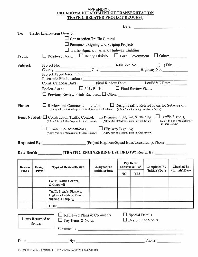
APPENDIX 6

OKLAHOMA DEPARTMENT OF TRANSPORTATIONPROJECT SUBMISSION LETTER
Office Engineer Use Only(Revised May 3, 2012)
To Office Engineer DivisionDate
From
Project Engineer/Project Manager Submitting Division
Subject
County & Route Project Number JP No.
Scheduled Letting Submission: G 90 Day G 60 Day (as approved)
G Emergency (as approved)
G Non-Federal Aid
G Federal Aid / Not onFHWA oversight list
G Federal Aid / On FHWAoversight list
Description (e.g. Grade, Drain, Surface)
Road Closure (check one)? QYes Q No
Location of Project
Environmental Clearance: G CE G EA Date of Evaluation/Re-evaluation ___________
404 PermitRailroadNPDES-NOIOther Permits/Agreements
G Attached, Date Approved ____________ G Pending G Not ApplicableG Attached G Not ApplicableG Attached G Not Applicable(see instructions) ____________________________________________________________________________________________________________________________________________________
Right-of-Way Certification Type G C1 G C2 G C3 Date _____________ G Not Applicable
Utilities Utilities Clear G Yes G No If “No”, expected out date: _____________ G Not Applicable
Contract Time __________ or Complete by Date ____________________ Estimate $ _____________
Flex Start G Yes (number of months ___ ) G No If “No”, Why not? QC/QA Minimum Bid(s)Bridge ________________
Roadway ______________
Total _________________
G Not Applicable
Extension of Notice to Proceed (Traffic Projects) G 90 Day G 120 Day G N/A
Delayed Work Order G No G YesIf “Yes”, reason for delay?
Special Provisions - The following job specific special provisions are needed in addition to the general special provisionslisted on the attached sheet (e.g. A+B Bidding, Lane Rental, Incentive/Disincentive).
List Tied Jobs (if applicable). Please circle Optional or MandatoryCounty Project Number JP No.
cc: Federal Highway AdministrationPrograms Division
APPENDIX 7

OKLAHOMA DEPARTMENT OF TRANSPORTATIONPROJECT SUBMISSION LETTER
Revised March 1, 2012
INSTRUCTIONS ON FILLING OUT PROJECT SUBMISSION LETTER:
Date - Indicate the month, day, and year the project is submitted (signed in) to Office Engineer.
Project Engineer/Project Manager - Fill in the name of the individual responsible for the overall submittalof the project. This must be an ODOT employee. Submission by Consultants will not be accepted. This couldbe the lead engineer, the project manager, or the principal designer, but this will be the person first calledshould there be a problem with the PS&E submittal.
Submitting Division - Fill in the name of the Division where the individual responsible for the overallsubmittal of the project works (e.g. Bridge, Roadway, Traffic, Local Government, Maintenance, etc.)
Route & County - Fill in the highway number and county in which the construction of the project occurs.In the case of multiple routes along the same corridor adhere to the following hierarchy in ascending numericalorder: U.S. Highways, State Highways, Local Roads. This information should agree with JPINFO.
Project Number - Fill in each project number listed on the title sheet of the plans. Verify that this matchesthe program information.
JP No. - Fill in each JP number listed on the title sheet of the plans. Verify that this matches JPINFO.
Scheduled Letting - Fill in the month that the project is to be let. Programs Division (JPINFO) should agreewith this date.
Submission - The standard project submission is 90 days before its scheduled letting. Any projects turnedafter the 90 day period are considered late and must be cleared with Office Engineer prior to submitting theproject. Projects which are not approved for 60 day submittal will not be accepted as such and will need toslide to a future letting. Emergency projects are only those deemed as such by Senior Staff members.
Federal ParticipationIndicate the type of federal participation (if any) associated with the project:
- Non-Federal Aid - no federal money is being used to fund the project.- Federal Aid/Not on FHWA oversight list - federal money is being used on some or all of the
funding for the project, but the project is not on the FHWA oversight list.- Federal Aid/On FHWA oversight list - federal money is being used on some or all of the funding
for the project, and the project is on the FHWA oversight list. Oversight projects are typically
designated with an “(” in JPINFO.
Description - Briefly list the categories of construction for the project (e.g. Grade, Drain, Surface & Bridge,Traffic Signal and Intersection Modification, etc.). Description of work type should match what is shown onthe Title Sheet of the plans, and what is shown in JPINFO.
Location of Project - Describe in detail where the project is located. In listing the location, the project’sbeginning and ending should be clearly identifiable on an Oklahoma state map (e.g. US 270 from US 412 inElmwood, extending north 2.65 miles).
APPENDIX 7

OKLAHOMA DEPARTMENT OF TRANSPORTATIONPROJECT SUBMISSION LETTER
Revised March 1, 2012
Environmental Clearance - If applicable, include the project’s environmental clearance document from theODOT Environmental Programs Division with the submission. Indicate on the submission letter the categoryof the clearance granted (CE or EA) and give the date of clearance. If the environmental document has beenre-evaluated please list the re-evaluation date also. This information can be obtained on the IMS or fromEnvironmental Programs Division.
404 Permit (also known as the Corp. Of Engineers Permit) - Multiple 404 Permits may exist for one project(e.g. one independent permit for a bridge and one independent permit for a separate RCB structure). Includeall 404 Permits applicable to the project.
Railroad Agreement - Include copies of all railroad agreements associated with the project. Contact RailPrograms Division for assistance.
NOI (Notice of Intent) - Any project with one acre or more of ground disturbing activities must have a DEQNotice of Intent. If applicable, include this notice with the submittal. Any NPDES provisions incorporatedin the plans (i.e. Stormwater Pollution Prevention (SWPPP) plan sheets) should be reviewed by the ODOTStormwater Manager in Environmental Programs Division.
Other Permits/Agreements - Some infrequently used permits/agreements that are encountered in highwayconstruction include Coast Guard, Tribal Agreements, FAA Notices (FAA), Hazardous Waste, OklahomaWater Resources Board (OWRB), and Municipal Agreements.
- Coast Guard Permits are required to construct or modify a bridge or causeway over a U.S.navigable waterway. The legal definition of navigable waterway is defined in 33 CFR 2.05-25.
- Oklahoma Water Resources Board (OWRB) - If it is determined that an Oklahoma WaterResources Board Permit is required, include a copy of the permit with the submittal. Copies of theletter stating the permit is not required do not need to be submitted with the project.
- FAA Notice (Airports) - The Contractor may be required to file FAA Form 7460 if any equipmentused in construction (such as a temporary crane) exceeds the height of an imaginary surfaceextending outward and upward at 100:1 from the nearest point of the nearest runway. Requestspecial provision 107-12, Federal Aviation Regulations, from Office Engineer Division. Completethe provision by filling in the required information, and return it with your project submittal. SeeFAA Form 7460-1, Notice of Proposed Construction or Alteration, for further guidance.
Right-of-Way - With the exception of right-of-way clearance contracts, every federally funded project musthave a right-of-way certification regardless of whether or not there is any additional right-of-way acquired.The FHWA will not authorize the use of federal funds for construction without a right-of-way certification.Since federal funds may be used in any phase of a project, Right-of-Way & Utilities Division usually suppliesa right-of-way certification on most projects regardless of funding source for construction. Indicate on thesubmission letter the type of certification granted (e.g. C1, C2, or C3) and give the date of clearance. ContactRight-of-Way & Utilities Division for assistance.
Utilities - Projects without right-of-way acquisition may still have utility relocation issues. If applicable,include the project’s Utility Relocation Information letter from the ODOT Right-of-Way Division’s UtilitiesBranch. Indicate the status of the utilities being relocated. Contact Right-of-Way Division for assistance.
APPENDIX 7

OKLAHOMA DEPARTMENT OF TRANSPORTATIONPROJECT SUBMISSION LETTER
Revised March 1, 2012
Contract Time or Complete by Date - Indicate the number of days determined to complete the constructionof the project, or indicate the date that the construction needs to be completed (but not both). The designershould complete a construction CPM or other approved method to determine contract time. Contact PhilLoafman, Project Scheduling Coordinator, for assistance.
Flex Start - Office Engineer typically sets a standard flex start date of about four (4) months from the LetDate. The Contractor has the “flexibility” to begin construction anytime after the Notice to Proceed, but beforethe flex start date. If you want something other than the standard flex start date, or you don’t want a flex startdate at all, please make note of such on the submission letter.
Extension of Notice to Proceed - This extension is typically only used with signal projects. By extendingthe Notice to Proceed date, it allows the Contractor to either wait to begin construction, or suspend contracttime when it is necessary to delay the project to allow for the fabrication of manufactured traffic control items.When applicable, extension time should be either 90 days or 120 days and should be indicated on the form.
Delayed Work Order - A delayed work order allows the project to be let, but prevents the Contractor frombeginning construction until a specified time, normally within two to three months of the letting. If the workorder needs to be delayed more than 3 months you should really consider programming the project for a laterletting.
Estimate - Provide the estimate as generated by the Proposal and Estimates System (PES). This is the totalamount including all parts of the project but does not include the 6% E & C.
QC/QA Minimum Bid(s) - List the amount of the minimum bid for Quality Control for insertion into SpecialProvision 648-1QA. Please round to the nearest hundred dollars, or nearest thousand for larger projects. Forguidance on QC/QA minimum bids see the memo distributed by Bill Gamel dated September 5, 2003,“Estimated Costs for Contractor Quality Control (QC) Activities.”
Special Provisions - A list of the general special provisions can be viewed and downloaded from the intranet.Special provisions required for your project should be indicated on this list and attached to your submissionletter. Please use the latest list of general special provisions provided on the intranet. If your project requiresjob specific special provisions that are not shown on the list, then give their description here. Unless you havehand-written a new special provision or modified an existing provision, please do not submit copies of the jobspecific special provisions since Office Engineer Division has no way of determining if what you submit isthe latest version. Asking for it on the submittal letter will suffice.
Tied Jobs - Please list all tied jobs and indicate whether they are to be mandatorily tied or optionally tied.Tied projects need to be submitted at the same time. If they are mandatorily tied, please make the necessaryadjustments to the pay items, such as carrying Mobilization or Field Office on only one of the projects.
APPENDIX 7

ODOT Special Provisions to the 2009 ODOT Standard SpecificationsApril 25, 2014
Special Provisions marked “Sample” or “Project Specific” must receive approval from Office Engineer Division.
Spec. No. Special Provision Use . . .
G 102-4A + B Bidding
(Traditional Bid + Incentive/Disincentive Payment)At the discretion of the designer and/or field.
G 103-1 Bonding Requirements On all right-of-way clearance projects.
G 104-1 Railroad FlaggingWhen the project has RR R-O-W, and
flagging is paid separately.
G 104-2 Railroad FlaggingWhen the project has RR R-O-W, and
flagging is paid under other items of work.
G 107-8 Legal Relations and Responsibility to Public (Railroad Insurance)Anytime RR R-O-W is involved (Rail
Programs Division should be consulted).
G 107-12 Federal Aviation Regulations When construction is near an airport.
G 108-1 Progress and Prosecution for Right-of-Way Clearance Contracts On all right-of-way clearance projects.
G 108-2Administration and Extension of Contract Time (Winter Time
Suspension)
When construction is expected to occur
between December 21 and February 15 .st th
G 108-5 Prosecution Progress (90 Days)When contract time may be suspended for the
fabrication of traffic items.
G 108-6 Prosecution Progress (120 Days)When contract time may be suspended for the
fabrication of traffic items.
G 108-23 Flexible Notice to ProceedAt the discretion of the designer and/or field.
Used to delay the work order.
G 108-27 Delayed Notice to ProceedTo prevent construction from beginning
before a specified date.
G 108-81 Disincentive for Exposed Cold-Milled Pavement When cold-milling asphalt driving surfaces.
G 108-182 Subletting of Contract (70%)
When the Prime Contractor is unable to
perform 50% or more of the contract work
due to the nature of the construction activities.
G 109-3 Price Adjustment for Fuel
On projects with a duration around 180
calendar days, and moving at least 50,000 CY
of combined excavation, borrow, and/or
embankment.
G 109-7 Price Adjustment for Asphalt BinderOn all AC paving projects (Do not use on
AC/PC alternate projects).
G 110-1 General Provisions for Use of Electronic Data
When the Department is providing electronic
design data to the Contractor for the purposes
of bidding and/or construction using
Automated Machine Guidance (AMG)
technology.
G 201-1 Eastern Red Cedar EradicationTo encourage the removal of Red Cedar trees
within the project right-of-way.
G 202-2 Osage Nation Mineral Reservation Sandy Soil Mining Permit
When excavating borrow material within, or
transporting borrow material out of Osage
county.
G 221-1 Temporary Fiber LogsWhen fiber logs are used as part of the
SWPPP.
G 246-2 Geogrid Earth ReinforcementWhen placing geogrid under an embankment
not under the roadway.
G 303-1 Aggregate Base
When aggregate base is being used as a
component of the typical section, and will be
allowed to be mixed on site.
G 303-2 Aggregate Base (Plant Mixed)
When aggregate base is being used as a
component of the typical section, and is
required to be plant mixed, and not mixed on
site.
G 317-8 Cement Treated BaseWhen a cementitious additive is to be used to
treat the subgrade of the paving section.
G 325-1 Moisture Barrier MembraneOn all projects using Moisture Barrier
Membrane.
APPENDIX 7

ODOT Special Provisions to the 2009 ODOT Standard SpecificationsApril 25, 2014
Spec. No. Special Provision Use . . .
Special Provisions marked “Sample” or “Project Specific” must receive approval from Office Engineer Division.
G 407-2 Bonded Hot Mix Asphalt
When paying for Polymer Modified Cationic
Rapid Set-1s (PMCRS-1s) instead of tack
coat.
G 407-3 Trackless Tack EmulsionWhen paying for Trackless Tack instead of
tack coat. Use with Special Provision 708-25.
G 410-1Milled Hot Recycling of Bituminous Material (Partial Depth)
2”+ Surface Recycling
When paying for Hot-In Place Recycled
Asphalt
G 411-3QAQuality Control and Acceptance Procedures for Plant Mix Asphalt
Concrete Pavement
With Special Provisions 643-6QA and
648-1QA when paying the Contractor for
quality control of asphalt pavement.
G 411-12 Longitudinal Joint Density On Asphalt Concrete Pavement On all AC paving projects.
G 411-13 Warm Mix AsphaltOn all Superpave projects; with Special
Provision 708-22
G 411-14 Asphalt Safety Edge
On asphalt highway construction (permanent
or temporary) when the following conditions
exists: the roadway is an open section, the
increase in pavement thickness is 2" or
greater, and the paved shoulder width is 4 feet
or less.
G 411-15 Rich Intermediate Layer (RIL)
As directed by the Pavement Design
Engineer, and/or as specified by the typical
section depicted in the plans.
G 411-16 Hot Mix Asphalt (Lime)
With Special Provision 708-27, when
hydrated lime or commercial lime slurry is
allowed as an anti-stripping agent.
G 411-17 Compaction of Hot Mix Asphalt On all AC paving projects.
G 411-18 Intelligent Compaction of AsphaltAs requested by the Field Division on asphalt
paving projects.
G 414-2QA Quality Control & Acceptance Procedures
With Special Provisions 643-6QA and
648-1QA when paying the Contractor for
quality control of concrete pavement.
G 414-17 Longitudinal FinishUpon Department approval of longitudinal
tining for the project.
G 415-1 Bituminous (Fiber Fill) Crack SealingWhen specifying a bituminous sealant which
contains fibers.
G 430-2QA Pavement and Bridge Deck Smoothness
When establishing pay adjustment factors for
quality of pavement or bridge deck
smoothness (Zero Blanking Band).
G 435-3 Fiber Reinforced, Bonded Portland Cement Concrete Overlay
When placing a fiber reinforced, bonded PCC
pavement overlay on an existing PCC
pavement.
G 504-1 Bridge Decks, Approaches, Rails and Parapets When constructing modular expansion joints.
G 504-2 Finger Type Expansion DeviceWhen constructing finger type expansion
devices.
G 504-6 Rail, Parapets, and Curbs
When the Contractor is allowed to place rail,
parapets, and/or curbs using slip form
methods.
G 504-7 Bridge Deck Finish on County Bridges On all county bridge deck projects.
G 507-1 Bearing AssembliesWith Special Provision 733-1, in all projects
that call for bearing assemblies.
G 513-1 Anodes When using anodes as part of the deck repair.
G 516-1 Pulse-Echo Testing of Drilled ShaftsWhen low strain impact integrity testing is
desired.
G 516-3 Drilled Shaft Foundations When constructing drilled shafts.
G 524-3 Fiber Reinforced Polymer Material
When structural strengthening using fiber
reinforced polymer composite wrap is
desired.
APPENDIX 7

ODOT Special Provisions to the 2009 ODOT Standard SpecificationsApril 25, 2014
Spec. No. Special Provision Use . . .
Special Provisions marked “Sample” or “Project Specific” must receive approval from Office Engineer Division.
G 535-1 Surface Applied Penetrating Corrosion Inhibitors
When the corrosion inhibitor is intended to
treat reinforcing steel 1 to 3 inches beneath
concrete surfaces which have been
contaminated with chlorides and may not be
exposed at the time of treating.
G 619-4 Plugging and Abandonment of Oil WellsTo specify the location and condition of each
well.
G 619-5 Oil Field Equipment RemovalTo specify the location and condition of oil
field equipment to be removed.
G 643-6QA Contractor’s Quality Control
With Special Provision 648-1QA, and Special
Provisions 411-3QA, 414-2QA, and/or
504-4QA when paying the Contractor for
quality control.
G 648-1QA Payment for Contractor’s Quality Control
With Special Provision 643-6QA, and Special
Provisions 411-3QA and/or 414-2QA when
paying the Contractor for quality control. The
amount entered in the Engineer’s Estimate
should be 1.2 times the amount calculated.
G 656-4 American Burying Beetle (ABB)When construction involves earth disturbing
activities in ABB sensitive areas.
G 701-14 Optimized Gradation for Portland Cement Concrete Pavement On all PC paving projects.
G 708-21 Reclaimed Asphalt Pavement and Shingles
Upon Department approval of the use of
recycled asphalt pavement and/or shingles on
the project.
G 708-22 Warm Mix Asphalt Material Requirements
With Special Provision 411-13, when warm
mix asphalt is allowed in the pavement
design; typically all AC paving projects.
G 708-23 Hamburg Rut Testing of Hot Mix Asphalt On all asphalt paving projects.
G 708-24Performance-Graded Asphalt Binder Using Multiple Stress Creep
Recovery (MSCR) Test
When Rich Intermediate Layer is specified for
the project; with Special Provision 411-15.
G 708-25 Material Requirements for Trackless Tack Emulsion With Special Provision 407-3.
G 708-26 Plant Mix Bituminous Bases and Surfaces (Superpave)
On projects with an asphalt pay item for
Superpave (S2-S6), OGBB, PFC, OGFSC,
SMA, and/or RBL.
G 708-27 Lime for Asphalt Mixtures
With Special Provision 411-16, when
hydrated lime or commercial lime slurry is
allowed as an anti-stripping agent.
G 708-28 Multiple Stress Creep Recovery (MSCR) Testing On all PC paving projects.
G 711-1 Permanent Pavement Marking TapeWith 857(D), “Non-Removable Pavement
Marking Tape,” pay items.
G 724-1 Bridge Bearing Structural Steel In all projects that call for bearing assemblies.
G 726-1 Structural Steel Plate Pipe, Pipe Arches, and Arches On projects using flexible conduits.
G 733-1 Elastomeric Bearing PadsWith Special Provision 507-1, in all projects
that call for bearing assemblies.
G 737-2 Anti-Graffiti Coating SystemsWhen applying anti-graffiti stain to new or
existing concrete surfaces.
G 809-1 Bridge Navigation Lighting When paying for Bridge Navigation Lighting.
G 823-1 Temporary Traffic SignalsWhen using portable traffic signals as part of
the traffic control plan.
G 855-7 Traffic Stripe (Plastic)In all projects calling for plastic traffic stripe,
arrows, words, or symbols.
G 856-1 Traffic Stripe (Multi-Polymer)In all projects calling for multi-polymer traffic
stripe, arrows, words, or symbols.
G 857-2 Construction Zone Pavement Markings On all projects requiring stripe removal.
G 877-1 Portable Longitudinal BarrierWhen providing, placing, and/or relocating
portable longitudinal barriers.
APPENDIX 7

ODOT Special Provisions to the 2009 ODOT Standard SpecificationsApril 25, 2014
Spec. No. Special Provision Use . . .
Special Provisions marked “Sample” or “Project Specific” must receive approval from Office Engineer Division.
G 880-1 Plastic DrumsWhen using or allowing plastic drums as part
of the traffic control.
G 880-6 Temporary Roadway Lighting AssemblyWhen paying for temporary roadway lighting
assemblies.
G 882-2Portable Automated Real-Time Work Zone Information System
(Smart Work Zone)On projects utilizing Smart Work Zone.
APPENDIX 7

APPENDIX 8

APPENDIX 8

APPENDIX 9

APPENDIX 9

APPENDIX 10
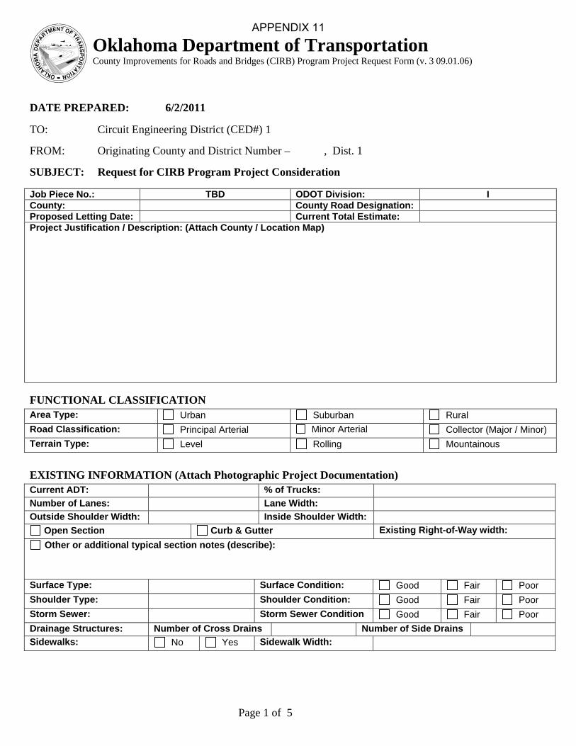
Page 1 of 5
Oklahoma Department of Transportation County Improvements for Roads and Bridges (CIRB) Program Project Request Form (v. 3 09.01.06)
DATE PREPARED: 6/2/2011 TO: Circuit Engineering District (CED#) 1 FROM: Originating County and District Number – , Dist. 1 SUBJECT: Request for CIRB Program Project Consideration Job Piece No.: TBD ODOT Division: ICounty: County Road Designation: Proposed Letting Date: Current Total Estimate: Project Justification / Description: (Attach County / Location Map) FUNCTIONAL CLASSIFICATION Area Type: Urban Suburban Rural
Road Classification: Principal Arterial Minor Arterial Collector (Major / Minor)
Terrain Type: Level Rolling Mountainous
EXISTING INFORMATION (Attach Photographic Project Documentation) Current ADT: % of Trucks:
Number of Lanes: Lane Width:
Outside Shoulder Width: Inside Shoulder Width:
Open Section Curb & Gutter Existing Right-of-Way width:
Other or additional typical section notes (describe):
Surface Type: Surface Condition: Good Fair Poor
Shoulder Type: Shoulder Condition: Good Fair Poor
Storm Sewer: Storm Sewer Condition Good Fair Poor
Drainage Structures: Number of Cross Drains Number of Side Drains
Sidewalks: No Yes Sidewalk Width:
APPENDIX 11
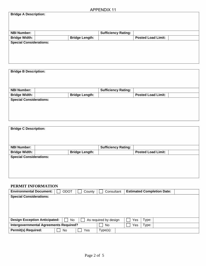
Page 2 of 5
Bridge A Description:
NBI Number: Sufficiency Rating:
Bridge Width: Bridge Length: Posted Load Limit:
Special Considerations:
Bridge B Description:
NBI Number: Sufficiency Rating:
Bridge Width: Bridge Length: Posted Load Limit:
Special Considerations:
Bridge C Description:
NBI Number: Sufficiency Rating:
Bridge Width: Bridge Length: Posted Load Limit:
Special Considerations:
PERMIT INFORMATION Environmental Document: ODOT County Consultant Estimated Completion Date:
Special Considerations:
Design Exception Anticipated: No As required by design Yes Type:
Intergovernmental Agreements Required? No Yes Type:
Permit(s) Required: No Yes Type(s):
APPENDIX 11

Page 3 of 5
PROPOSED SCOPE Proposed Project Termini Description: Beginning of Project: End of Project: Limits of Survey:
Proposed Typical Section Description:
Number of Lanes: Lane Width:
Outside Shoulder Width: Inside Shoulder Width:
Open Section Curb & Gutter Right-of-Way, Proposed width:
Other or additional typical section notes (describe):
Pavement Type: Shoulder Type:
Overlay: No Yes Thickness: Coldmill: No Yes Thickness:
Storm Sewer: No Yes Sidewalks: No Yes Sidewalk Width:
Proposed Bridge A Description:
Bridge Width: Bridge Length: Approach Length:
Proposed Bridge B Description:
Bridge Width: Bridge Length: Approach Length:
Proposed Bridge C Description:
Bridge Width: Bridge Length: Approach Length:
Proposed Drainage Structures Description:
CGSP, Number RCP, Number Roadway Size RCB, Number
APPENDIX 11
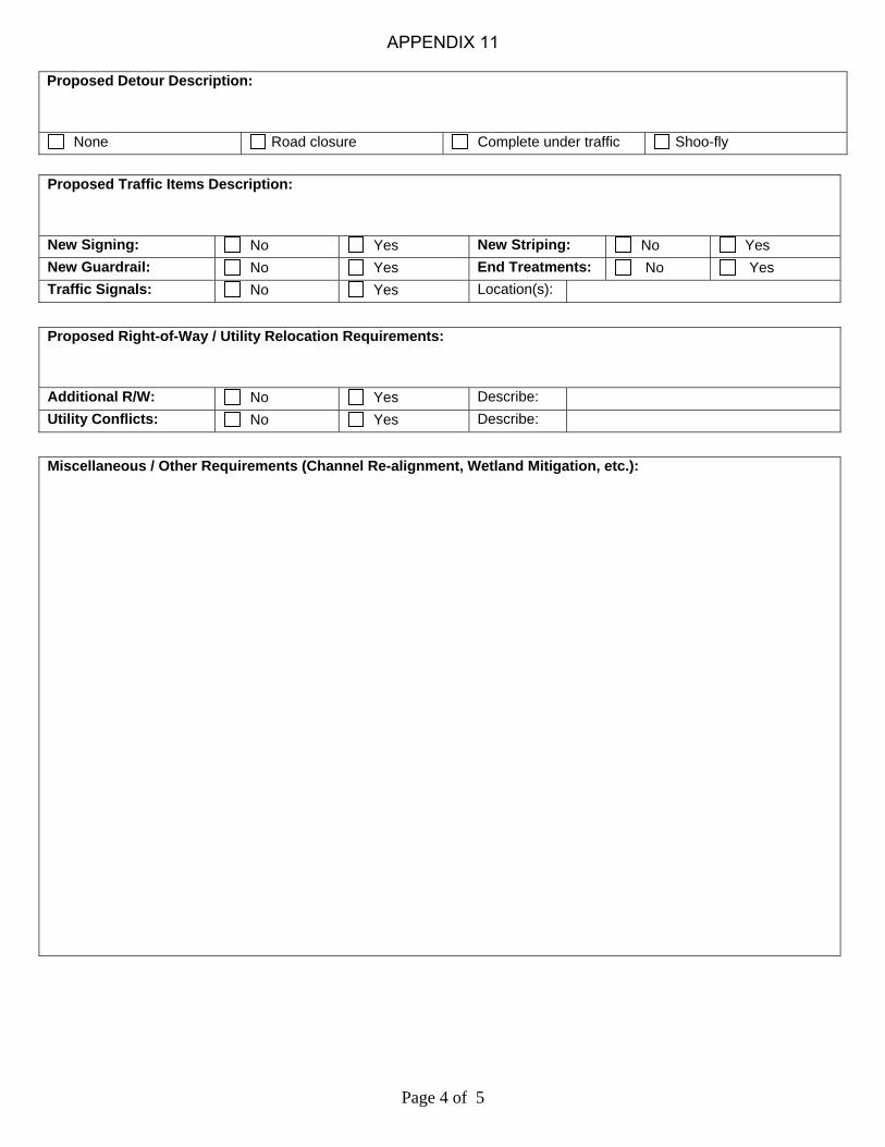
Page 4 of 5
Proposed Detour Description:
None Road closure Complete under traffic Shoo-fly
Proposed Traffic Items Description:
New Signing: No Yes New Striping: No Yes
New Guardrail: No Yes End Treatments: No Yes
Traffic Signals: No Yes Location(s):
Proposed Right-of-Way / Utility Relocation Requirements:
Additional R/W: No Yes Describe:
Utility Conflicts: No Yes Describe:
Miscellaneous / Other Requirements (Channel Re-alignment, Wetland Mitigation, etc.):
APPENDIX 11

Page 5 of 5
SCOPING ESTIMATE Category Description Estimated Cost Comments
Environmental Clearance $
ROW / Utility Coordination $
Design Engineering $
Construction Engineering / Inspection $
Sub Total Project Services $
Right-of-Way Acquisition $
Utility Relocation $
Sub Total RW / UT $
Roadway $
Bridge $
Drainage Structures $
Erosion Control $
Traffic Control $
Signing and Striping $
Traffic Signals $
Mobilization $
Staking $
Sub Total Construction $
Miscellaneous / Contingencies $
$
$
$
$
Total Project Estimate $
CIRB Funding Request $
Other Funding Participation $
ATTACHMENT LIST (Check as applicable): County / Location Map
Aerial Photography
Photographic Project Documentation
Accident Data Sheets
Certified Traffic Counts
Bridge Inspection Reports
Plans
Other (Describe):
APPENDIX 11

Effective 9/15/09 REV.9/9/09 Page 1 of 3
Local Government NEPA Study Checklist ________________________________________________ Introduction The purpose of this checklist is to ensure that a consistent level of information is provided to the Environmental Programs Division for the initiation of NEPA studies. This is intended to expedite the field review of proposed projects, minimize requests for additional information, and reduce the incidence of repeated field investigations or follow-up interagency consultation. Study requests which do not contain ALL the information or attachments identified on this checklist will be returned, with an explanation of what is needed before NEPA clearance can begin. The effective start date for the NEPA process is when all required information has been received by the Environmental Programs Division. Please submit the completed form with study footprint/plans and other supporting documents to the Assistant Division Engineer, Environmental Programs Division through Local Government Division. THIS INFORMATION NEEDS TO BE SUBMITTED FOR ALL PROJECTS REGARDLESS OF WHETHER NEPA IS BEING DONE IN-HOUSE OR BY A CONSULTANT HIRED BY THE CITY/COUNTY. I. Project Information The following information must be present: Federal Aid Project No: State Job Piece No: County(ies): County Road No. or City Street Name: Project Description from JPINFO: Anticipated Let Date: II. Funding Information This information is needed to determine if the project needs NEPA. If the project currently has federal funds or has potential for federal funds in the future, a full NEPA document is needed. If the project requires a 404 permit only and the project is being let through ODOT, only the cultural resources, biological and hazardous waste studies will be done and no NEPA document will be prepared. If the project is let by County or City, the County/City will be responsible for the studies.
The Project currently has federal funds The Project has potential for future federal funds The Project does not have federal funds but will require a 404 permit and will be let by ODOT
II. Description of Existing facility (Roadway) If a roadway project, project description or plans must include the following: Existing No lanes Shoulders/type (Sod, Paved,etc) Existing sidewalks (Circle applicable ones) YES/NO LT/RT/BOTHSIDES Functional classification Traffic: Present ADT vpd Future ADT (20 year Projection) vpd III. Description of Existing facility (Bridge) If a bridge project, project description or plans must include the following: NBIS No.: Location No.: Existing Bridge Width: Name of water body or facility crossed (RR, etc): The bridge is currently (Check all applicable ones)
Load Posted Open to Traffic Closed to Traffic
IV Purpose & Need for the Project The reason why the project is needed (Check all that apply)
Infrastructure Deficiency (Structurally deficient bridge, Poor Pavement, etc.) Geometric Deficiency (Functionally obsolete or narrow bridge, Inadequate vertical clearance, Narrow
shoulders, sidewalks not meeting ADA requirements, etc.) Safety (Provide accident data and describe the feature contributing to accidents)
APPENDIX 12

Effective 9/15/09 REV.9/9/09 Page 2 of 3
Inadequate Capacity (Traffic volume exceeds existing capacity) Legislative Mandate (Provide copy of the mandate) Other (Economic development, Connectivity, Emergency Repair, etc. Describe).
For ER funded projects, please provide the description of event which qualified the project for ER funds: V Proposed Work The following must be indicated (Check all that apply)
Roadway Capacity Expansion(from 2 lanes to 4 or 6 lanes) New or offset alignment Add/improve shoulders Overlay/Pavement repair Vertical/horizontal curve corrections Signalization Auxiliary/Turn lanes Sidewalks Bridge replacement. Bridge rehabilitation Other (Describe)
VI. Description of Proposed Improvement Work Proposed Typical No of Lanes Width of Driving Lanes ft Type of Driving Surface (Paved, Gravel, etc.) Width of Shoulder ft Type of Shoulder (Paved, Gravel, Sod, etc.) Proposed Bridge Proposed Structure (Span, RCB, etc.) Proposed Bridge Width ft Project Description PROVIDE A BRIEF DECRIPTION OF THE PROPOSED WORK (eg. Adding shoulders & turn lanes from Sec Line EW 65 to EW 66 on NS 467, Bridge replacement on EW 67 over Coon Creek, Reconstruction of Rock Creek Road from 2 to 4lane section from 24th Street to 36th Street, etc.) VII. Type of Detour The following must be indicated (Check one)
None, road closed Road closed, traffic detoured on existing roads Shoofly requiring permanent or temporary new R/W (INDICATE WHETHER SHOOFLY IS LOCATED
EAST/WEST/NORTH/SOUTH of Existing Bridge) Keep existing facility open (INDICATE WHETHER OFFSET IS TO EAST/WEST/NORTH/SOUTH of
EXISTING ALIGNMENT) VIII. Location Map
PROVIDE A LOCATION MAP. It can be a Section of County Map or Plan cover sheet, or equivalent showing location of project with respect to identified county roads, towns, features, and legal locations (township, range, sections) IX. Detailed Project Footprint Map (Can be one of the following):
Set of preliminary or P-I-H plans – Include Title, Typical, Plan & Profile sheets, General Bridge Plan sheet, and Cross Sections. Plans should show existing facility and proposed improvements, existing and proposed new R/W, and any temporary R/W expected for shoofly detours or channel work.OR
Preliminary study area based on reasonable estimate of proposed/anticipated new/temporary R/W and the proposed typical section including any sidewalks and bridge width. The project study footprint should be drawn to scale on a suitably enlarged USGS 7.5 minute quadrangle or a an excellent-quality aerial photograph with a minimum 400:1 scale. Scale and quality must be adequate to
APPENDIX 12

Effective 9/15/09 REV.9/9/09 Page 3 of 3
allow field personnel to easily correlate the project area to existing facility, adjacent landforms and structures. For some issues, preliminary design/R/W plans will be necessary to determine effects and will be requested as soon as this becomes apparent. X. Ground Disturbance, Right of Way & Relocations/Structure removals (check all applicable ones)
Involves ground disturbance outside of existing pavement. New/temporary R/W required Project will require relocations/demolitions of adjacent buildings (show on attached map or plans) Project will not require relocations/demolitions
XI. Public Involvement (attach required correspondence(s))
For ALL projects with new permanent or temporary R/W, attach a letter from the County Commissioners or the City that all property owners in the study area have been notified of the proposed project and are aware that ODOT specialists will be accessing their property to perform follow up studies.
For URBAN capacity expansion projects which would normally require a public meeting or notice, attach a letter indicating the Local Authority has already, or intends to, conduct a public involvement program. XII. Noise (check if project is in an urban/suburban area and involves capacity expansion)
Design Traffic Data which includes the current and projected future AADT, K (DHV/AADT-two way), T (% medium trucks of DHV), T (% medium trucks of AADT), T3 (% heavy trucks of AADT) and design speed. XIII. Section 4(f) and 6(f) Properties
None known in area Yes. If any known public parks, recreation areas, and wildlife/waterfowl refuges are present, show on
attached quads or aerials XIV. Historic Bridges Is the bridge listed as historic (NRHP eligible) in the 2007 Spans of Time (Can be found at http://www.okladot.state.ok.us/hqdiv/p-r-div/spansoftime/pdfs/survey-phase1.pdf) ?
No Yes. If yes, provide the information required to start the Section 4(f) process as per the requirements listed in the Section 4(f) memo from ODOT Cultural Resource Specialist (Please check with Environmental Programs Division for the latest version). XV. Traffic Impact or Alternate Studies
Attach available traffic impact studies for urban capacity expansion projects. Attach available alternative analysis for projects on new alignments.
XVI. For urban projects
The project is located within the ACOG, INCOG or Lawton Metropolitan Area The project is included in the Long Range Plan for the City or ACOG/INCOG/Lawton Metropolitan Area The project is included in the TIP for the ACOG/INCOG/Lawton Metropolitan Area The project is NOT located within the ACOG, INCOG or Lawton Metropolitan Area
XVII. For projects with existing or proposed sidewalks
The project is located on the City’s Master Plan for Pedestrian trails Other needs for sidewalk (such as school, parks, Transit stops, etc. Describe)
ENVIRONMENTAL REVIEW CANNOT BEGIN UNTIL ALL NECESSARY INFORMATION IS PROVIDED.
APPENDIX 12

3/18/2013
Instructions and Guidance for the Regulatory Provisions Checklist for Non-FHWA Funded Projects
Projects which are State or County funded and not funded with any Federal Highway Administration (FHWA) funds, or involve any FHWA approvals do not require a NEPA document approved by FHWA. However, there are numerous State and Federal laws and permits that may apply. The permits and provisions that may be stipulated as part of the environmental review are part of the oversight required for ODOT to follow during the construction phase of the projects. If applicable, these permits and provisions are required before ODOT can place a project on a bid letting, and are obligations of any project sponsor regardless of the letting or contracting process used. In order to assist the Counties in completion of the Checklist for Environmental review, the following information and guidance is provided on the standard environmental reviews and permits required for environmental compliance on transportation projects.
1. A Section 404 Clean Water Act Permit is required from the US Army Corps of Engineers (USACE) for any projects involving temporary or permanent fill in jurisdictional waters or wetlands (http://www.swt.usace.army.mil/Missions/Regulatory.aspx ). A 401 water quality certification is required from Oklahoma Department of Environmental Quality (DEQ) to accompany the 404 Permit. There are 3 types of permits, Nationwide Permits, General Permits (for which standard 401 Certifications have been issued by DEQ), and Individual Permits, which require a separate 401 certification from DEQ. A professional trained in wetlands delineation should review the project to determine if any wetlands will be impacted. The project’s design engineer can review the USGS 7.5 minute Quadrangle map for “blue line” streams, review the project locale for bed and bank indicators of an Ordinary High Water Mark (OHWM), and review the project design for excavation, and/or fill, both permanent (like piers, rip rap, or RCB’s) and temporary (like contractor work roads) to determine if a 404 permit and the required support studies are necessary. In order to be covered by and compliant with a 404 permit, a cultural resources professional who meets or exceeds the Secretary of Interior Standards for archeology or architectural history as defined in 36 CFR 61 (http://www.nps.gov/history/local-law/arch_stnds_9.htm) must review the project to determine if there is an effect on any properties eligible for or listed on the Nation Register of Historic Places. If so, a preconstruction notice and cultural resources documentation must be sent to the US Army Corps of Engineers Tulsa District for their use to complete the USACE’s Section 106 Consultation Requirement. Additionally, the USACE must be notified through a preconstruction notice if any listed species or its designated critical habitat might be affected or is in the vicinity of the project. Information regarding this project review process is listed next.
2. The procedures and process to conduct a review of a project’s potential impacts on
federally listed threatened and endangered species can be found at http://www.fws.gov/southwest/es/oklahoma/OKESFO%20Permit%20Home.htm. Follow
APPENDIX 13
1

3/18/2013
the project review steps for “Projects without a Federal Nexus”.
(A) If your ESA section 7 determination for any species is “may affect, likely to adversely affect” or “not likely to adversely affect/modify” or for critical habitat is “likely to adversely modify," submit the project review package to USFWS for review under Section 9 of the ESA. Complete and print the online project review request (PDF) and submit along with your entire project review package.
B) If your ESA section 7 determination for each species and critical habitat is “no effect,” you may print off the project review package to include in your files for compliance under Section 9 of the ESA. No further coordination with USFWS is necessary.
Note: If a 404 permit is required for the project, this is a Federal Nexus. If the Project Review meets the conditions under (A), a Preconstruction Notice and this project review documentation must be sent to the US Army Corps of Engineers Tulsa District for their use to complete the USACE’s Section 7 Consultation Requirement under the Endangered Species Act.
3. The Bald and Golden Eagle Protection Act (BGEPA) prohibits any actions which disturb/agitate an eagle to the degree that causes or is likely to (1) cause injury, (2) interfere with breeding, feeding or sheltering behavior, or (3) nest abandonment. It is recommended that a professional wildlife biologist to review the proposed action and action area to ensure that the action will not violate the BGEPA. Generally, activities farther than 66o feet from a nest are not restricted. More information on the BEGPA can be found at http://www.fws.gov/migratorybirds/BaldEagle.htm .
4. The Migratory Bird Treaty Act prohibits the taking, killing, possession, transportation, and importation of migratory birds, their eggs, parts, and nests except as authorized under a valid permit (50 CFR 21.11). Cliff and Barn Swallows frequently nest on transportation structures. It is recommended that a professional wildlife biologist to review the proposed action and action area to ensure that the action will not violate the MBTA, or the project is planned in such a way to avoid the active nesting season of the swallows. This is typically achieved through plan notes and scheduling. More information on the MBTA can be found at http://www.fws.gov/laws/lawsdigest/migtrea.html .
5. To manage environmental risk and liability associated with industrial or hazardous wastes, and to protect public health and workers’ health and safety, an Initial Site Assessment, which consists of an environmental database search, along with a field visit to verify the conditions is recommended. The work generally consists of the following:
A. Identification of known or potential hazardous waste sites located in the proximity of the study area (using ASTM E1527-05 radius guidelines): This consists of a database search of both the federal and state environmental records.
B. Identification of Above Ground Storage Tanks (AST), Underground Storage
Tanks (UST), Leaking Underground Storage Tanks (LUST) Sites and oil wells
APPENDIX 13
2

3/18/2013
located within 1/8th of a mile of the study area: This consists of a file review from the Oklahoma Corporation Commission (contact the appropriate District Office) for any past or present Oil and Gas activity – including salt water disposal. This includes any information regarding the location of drilled wells, records of completion and plugging, field inspection reports, reported leaks, spills or violations of any kind.
C. Identification of any current and abandoned coal mines within the study area.
This information can be found from historic aerial photos and topographical maps.
D. Field visit to verify and supplement the above information.
Findings from this assessment may include avoidance plan notes, or identification of a known environmental concern that needs to be properly managed prior to or during construction.
6. Archeological sites and unmarked human burial sites are protected by the Oklahoma Antiquities Law and the Burial Desecration Law. Even if all the work is done within the existing right-of-way, there is potential for archeological sites or burial sites within existing right-of-way. To ensure compliance with these State Laws, a file search is recommended to identify potential archeological sites, cemeteries, and other historic properties within or immediately adjacent to the project area. The County can request the following cultural resource information located within the study area from ODOT Cultural Resources Program. The request should include the location map, and an aerial or USGS topographic map with the study limits on a 1”=400’ scale. The County should allow 30 days to obtain the information for projects less than 1 mile long and 60 days for longer projects. The information includes:
A. Archaeological Sites a) Prehistoric and historic archaeological sites recorded with the
Office of the Oklahoma Archaeological Survey (OAS). b) Early historic buildings or other resources identified on
Government Land Office (GLO) maps c) Other previously identified cultural resource site.
B. Historic Cemeteries
C. National Register of Historic Places (NRHP) properties
Buildings, structures, or districts that have been determined eligible or formally listed on the NRHP that are within or immediately adjacent to the study limits.
Note: All historic properties identified during this process shall be shown on study maps for internal use only. The public disclosure of the location of some types of historic properties is a violation of Federal laws and regulations.
APPENDIX 13
3

3/18/2013
7. Projects on or adjacent to Oklahoma’s Scenic Rivers must be coordinated with Oklahoma
Scenic Rivers Commission (OSRC), as specified in Title 82 §1452. This includes the following rivers:
a. Flint Creek and the Illinois River above the confluence of the Barren Fork Creek in Cherokee, Adair and Delaware Counties;
b. Barren Fork Creek in Adair and Cherokee Counties from the present alignment of Highway 59 West to the Illinois River;
c. Upper Mountain Fork River above the 600-foot elevation level of Broken Bow Reservoir in McCurtain and LeFlore Counties, and portions of
d. Big Lee's Creek, sometimes referred to as Lee Creek, located in Sequoyah County, above the 420-foot MSL elevation, excluding that portion necessary for a dam to be built in the State of Arkansas with a crest elevation of no more than the 420-foot MSL elevation; and
e. Little Lee's Creek, sometimes referred to as Little Lee Creek, located in Adair and Sequoyah Counties, beginning approximately four (4) miles east-southeast of Stilwell, Oklahoma, and ending at its conjunction with Big Lee's Creek approximately two (2) miles southwest of Short, Oklahoma.
Comments from OSRC and the County’s response to the OSRC comments should be included in the project record.
8. A project that disturbs one acre or more requires an Oklahoma Department of Environmental Quality (DEQ) GENERAL PERMIT OKR10 - FOR STORM WATER DISCHARGES FROM CONSTRUCTION ACTIVITIES WITHIN THE STATE OF OKLAHOMA available at http://www.deq.state.ok.us/wqdnew/stormwater/OKR10Permit_2012_final%20Review_August.pdf . Please consult the general permit for specific requirements. This permit also has special requirements for discharges into impaired waters and any Oklahoma Sensitive Waters and Watersheds Harboring Endangered and Threatened Species and Their Critical Habitat of Concern. The following procedure is used to identify the impaired waters and sensitive waters.
A. Identification of any Oklahoma's 2010 303(d) list of impaired waters This information can be obtained from the Flex Viewer map located in the Oklahoma Department of Environmental Quality’s Website at http://www.deq.state.ok.us/mainlinks/gis/index.html B. Identification of any Oklahoma Sensitive Waters and Watersheds Harboring
Endangered and Threatened Species and Their Critical Habitat of Concern required for the Storm Water Permit Conditions.
This information can also be obtained from Appendix A of the GENERAL PERMIT OKR10 - FOR STORM WATER DISCHARGES FROM CONSTRUCTION ACTIVITIES WITHIN THE STATE OF OKLAHOMA available at http://www.deq.state.ok.us/wqdnew/stormwater/OKR10Permit_2012_final%20Review_August.pdf
APPENDIX 13
4

3/18/2013
9. The County will need to identify if there are any Airport/Airfield located within 4 miles
of this project. If so, the proposed action may require notifying the Federal Aviation Administration (FAA) of proposed construction via FAA Form 7460-1 prior to construction. If an FAA Permit is required, it must be included in the PS&E submittal to Office Engineers.
10. For projects that cross Traditionally Navigable Waters, a Section 10 Rivers and Harbors
Act of 1899 (RHA) permit is required from the Tulsa District Corps of Engineers. For more information see: http://www.usace.army.mil/Portals/2/docs/civilworks/regulatory/materials/rhsec10.pdf The list of these in waters in Oklahoma and maps are located at: http://www.swt.usace.army.mil/Missions/Regulatory/Section10Waters.aspx .
11. For bridge projects crossing or affecting navigable waters used for interstate commerce, a Section 9 U.S. Coast Guard Permit (USCG) may be required. The Coast Guard approves the location and clearances of bridges through the issuance of bridge permits or permit amendments, under the authority of the General Bridge Act of 1946, Section 9 of the Rivers and Harbors Act of 1899, and other statutes. This permit is required for new construction, reconstruction or modification of a bridge or causeway over certain waters of the United States. For more information go to: http://www.uscg.mil/hq/cg5/cg551/BPAG_Page.asp
Please be aware that any time a federal permit is required, the National Environmental Policy Act requirements of that federal agency will come to bear upon the project. This may affect the need for additional studies (Cultural Resources, Endangered Species, etc.) in order to receive the required permit.
APPENDIX 13
5

1
RESOLUTION NO. ______
BE IT RESOLVED BY THE BOARD OF COUNTY COMMISSIONERS OF <INSERT COUNTY NAME> COUNTY, OKLAHOMA:
THAT, WHEREAS it is in the best interest of <INSERT COUNTY NAME> County, to certify that no federal funding will be utilized in the execution of the project described as <INSERT PROJECT DESCRIPTION>, Project Number <INSERT PROJECT NUMBER>, State Job Piece Number <INSERT STATE J/P NUMBER>; and WHEREAS the Board of County Commissioners of <INSERT COUNTY NAME> County certifies that the regulatory provisions described on Page 2 of this Resolution have been addressed as indicated; and WHEREAS the Board of County Commissioners of <INSERT COUNTY NAME> County accepts and agrees that all costs associated with contractor delays or additional project costs that are incurred due the failure to secure a required permit(s) or non-compliance with permit requirements or regulatory provisions will be borne solely by the County; NOW, THEREFORE, it is hereby resolved that the Board of County Commissioners of <INSERT COUNTY NAME> County is hereby authorized and directed to execute and signify that the provisions have been met on behalf of <INSERT COUNTY NAME> County, and duly signed by the Board of County Commissioners of <INSERT COUNTY NAME> County this _____ day of ___________________, _________.
APPROVED AS TO FORM AND LEGALITY:
Board of County Commissioners County of <INSERT COUNTY NAME>:
District Attorney Date Chairman Date
ATTEST:
Member Date
County Clerk (Seal)
Member Date
APPENDIX 14

2
COUNTY: STATE JOB PIECE NO.: Date
Certified Not
Applicable Regulatory Provision Comment
The Project does not require any permanent or temporary fill or excavation activities in jurisdictional waters or wetlands of the US as determined by a qualified professional.
A 404 permit has been issued by the US Army Corps of Engineers, Tulsa District (COE), and any required consultation under Section 106 of the National Historic Preservation Act and the Endangered Species Act has been completed. The Commission acknowledges that the project must comply with the General and special conditions associated with the 404 Permit and/or DEQ 401 Water Quality Certification. Permit # ____________ is attached to this certification.
The County certifies that required coordination with the U.S. Fish and Wildlife Service (Service) under the Endangered Species Act of 1973 (16 U.S.C. 1531-1544, 87 Stat. 884), as amended (ESA); and additional review by the Service, if necessary, was completed. http://www.fws.gov/southwest/es/oklahoma/OKESFO%20Permit%20Home.htm)
The Project will not impact active Migratory Bird breeding areas and complies with the Bald and Golden Eagle Protection Act.
The Project was reviewed for industrial or hazardous waste/or Leaking Underground Storage Tank concerns that may impact public health, workers’ health and safety, project cost, or schedule.
The project will not affect any recorded archeological or burial sites in compliance with the Oklahoma Antiquities Law (Title 53 Chapter 20 § 361) and Burial Desecration Law (Title 21 Chapter 47 § 1168).
The project was developed in coordination with the Scenic Rivers Commission in accordance with Title 82 §1461 (Only for Flint Creek and the Illinois River above the confluence of the Barren Fork Creek in Cherokee, Adair and Delaware Counties; Barren Fork Creek in Adair and Cherokee Counties from the present alignment of Highway 59 West to the Illinois River; the Upper Mountain Fork River above the 600-foot elevation level of Broken Bow Reservoir in McCurtain and LeFlore Counties, and portions of Lee and Little Lee Creeks in Adair and Sequoyah Counties, as specified in Title 82 §1452.)
One (1) acre or more of total ground disturbance is anticipated by the construction of the project, a DEQ OKR010 Construction Stormwater Permit will be required.
Within 4 miles of a general aviation airport, FAA Permit (under conditions listed in FAA Form 7460-1) may be required.
Section 10 Permit for work in traditionally Navigable Waters (COE)
Section 9 Coast Guard Permit for work in navigable waters used or susceptible to use in their natural condition or by reasonable improvement as a means to transport interstate or foreign commerce
APPENDIX 14

PROJECT SUBMISSION TO RIGHT-OF-WAY DIVISION
Off System RW Submission Deliverables from Local Government Division
Typical R/W submission 1 set full size construction plans (title, typical & P & P) with parcels shown on P&Ps 2 set half size construction plans (title, typical & P & P) with parcels shown on P&Ps (one of these with cross sections) 1 set draft conveyance instruments “Right-of-Way plans” of the type done for state projects are not required if the parcels can be clearly depicted on the construction plans. For some urban projects it may be beneficial to produce them. If “right-of-way plans” are produced, then please supply the following 1 set full size right-of-way plans 1 set half size right-of-way plans 1 set half size construction plans (title, typical & P & P) with parcels shown on P&Ps (with cross sections) 1 set draft conveyance instruments If there is no new r/w or utility relocations please supply No new r/w & utility affidavit 1 set half size plans If there is no new r/w, but there will be utility relocations please supply No new R/W affidavit 1 set full size construction plans (title, typical & P & P) 2 set half size construction plans (title, typical & P & P) (one of these with cross sections)
NOTE: On all submissions, specify source of funds for right-of-way and utilities. (ie local, CIRB, federal earmark) If state or federal funds are to be used for right-of-way or utilities, a funding agreement must be in place prior to submitting R/W. For Revisions Send 1 full size revised sheet 2 half size revised sheets 1 copy any revised conveyance instruments List of changed/deleted/added parcels A cover memo is required for all submittals to RW Division including NEPA clearance date and type
APPENDIX 15