Okfuskee County Oklahoma Long Range Transportation Plan
49
Okfuskee County Oklahoma Long Range Transportation Plan LRTP 5/10/2017 CORTPO 2017-2040 Florence Hotel about 1907 Weleetka, Oklahoma
Transcript of Okfuskee County Oklahoma Long Range Transportation Plan

Okfuskee County Oklahoma Long Range Transportation Plan LRTP 5/10/2017 CORTPO 2017-2040
Florence Hotel about 1907
Weleetka, Oklahoma

Okfuskee County 2040 Long Range Transportation Plan
i
Produced by:
Central Oklahoma Regional
Transportation Planning Organization
CORTPO
400 North Bell
Shawnee, Oklahoma 74801
Phone (405) 273-6410 Fax (405) 273-3213
www.coedd.net
Publication of this document was financed in part by funds provided by the United States Department of Transportation; Federal Highway
Administration. The provision of Federal financial assistance should not be construed as denoting U.S. Government approval of plans,
policies, programs or projects contained herein.
The Central Oklahoma Regional Transportation Planning Organization (CORTPO) complies with all civil rights provisions of federal statues and related authorities that prohibit discrimination in programs and activities receiving federal financial assistance. Therefore, the CORTPO does not discriminate on the basis of race, sex, color, or national origin, religion or disability, in the admission, access to and treatment in CORTPO programs and activities, as well as the CORTPO hiring or employment practices. Complaints of alleged discrimination and inquiries regarding the CORTPO RTPO’s nondiscrimination policies may be directed to the RPO Planner, Title VI & Title II Coordinator, 400 North Bell, Shawnee,
and Ok 74801, (405) 273-6410 or the following email address:[email protected]

Okfuskee County 2040 Long Range Transportation Plan
ii
Okfuskee County Long Range Transportation Plan
2016-2040
CORTPO In cooperation with:
The County of Okfuskee The Oklahoma Department of Transportation (ODOT)
Federal Highway Administration (FHWA) The Central Oklahoma Economic Development District
(COEDD) Council of Government
The 2035 Long Range Transportation Plan (LRTP) was developed through a cooperative effort among CORTPO, member jurisdictions, the Oklahoma Association of Regional Councils (OARC), and the
Oklahoma Department of Transportation (ODOT).

Okfuskee County 2040 Long Range Transportation Plan
iii
CORTPO POLICY BOARD
Gary Gray, Hughes County Commissioner Ricky Taylor, Lincoln County Commissioner Max Henry, Okfuskee County Commissioner Kent Bradley, Payne County Commissioner Dale Carter, Pawnee County Commissioner Randy Thomas, Pottawatomie County Commissioner John Kirby, Seminole County Commissioner Pat Griggs, City of Wetumka, Hughes County Jim Greff, City of Prague, Lincoln County Carl Hensley, City of Yale, Payne County Jim Copeland, City of Okemah, Okfuskee County Elzie Smith, City of Cleveland, Pawnee County Jimmy Stokes, City of Tecumseh, Pottawatomie County Representative, City of Seminole, Seminole County Valarie Silvers, City of Stillwater, Payne County Jim Collard, Citizen Potawatomi Nation Matt Goodson, Circuit Engineering
CORTPO Technical Committee
Mickey White, Paden Dr. Francis Shelton, Mayor of Boley Bill Elliott, Okfuskee County EM Evelyn Atkinson, City of Okemah Ralena Haddox, City of Okemah Technical Advisors: Laura Chaney, ODOT Brayden Cale, ODOT Kevin Bloss ODOT Division 3 Jim Copeland, City of Okemah
PLANNING STAFF
Peter Seikel, COEDD Director Gail Thomas, CORTPO Staff Planner
Okfuskee County 2040 Long Range Transportation Plan
iv
CORTPO Mission; Vision
A mission and vision were adopted by CORTPO for the purposes of planning for a sustainable regional
transportation system.
A mission statement is a statement which is used as a way of communicating the purpose of the organization. A
vision statement tends to be an aspirational description of what an organization would like to achieve or
accomplish in the mid-term or long-term future. Together, these statements are intended to serve as clear
guides for choosing current and future courses of action.
Mission
To work with public and private partners to develop and maintain the appropriate systems necessary for a safe,
efficient, and convenient multi-modal transportation system that will effectively move people and goods on a
coordinated transportation network that will advance and secure the economic prosperity and social equity for
all residents, visitors, and businesses within the CORTPO region.
Vision
A comprehensive and coordinated multi-modal transportation environment based on the principles of inclusion,
communications and innovation that will have the flexibility to respond to new technologies and methodologies
to enhance the CORTPO region’s position in the regional, national, and international markets as well as provide
accessible and affordable transportation services and opportunities to all of the region’s current and future
residents.
The current level of federal, state and local funds
will be inadequate to ensure long term maintenance
of roads, sidewalks, transit, and rail

Okfuskee County 2040 Long Range Transportation Plan
v
Table of Contents
Contents
CORTPO MISSION; VISION ......................................................................................................................................... IV
Mission .............................................................................................................................................................. iv
Vision ................................................................................................................................................................. iv
TABLE OF CONTENTS .......................................................................................................................................... V
SUMMARY COMMENTS ..................................................................................................................................... 8
Funding .............................................................................................................................................................. 8
Sustainability ...................................................................................................................................................... 8
LRTP Updates ..................................................................................................................................................... 8
Data Sources ...................................................................................................................................................... 9
A Policy and Project Plan .................................................................................................................................... 9
Identified Project Locations .............................................................................................................................. 10
Rumble Strip Placement ................................................................................................................................... 10
CHAPTER 1: INTRODUCTION; KEY ISSUES & GOALS .......................................................................................... 11
Background Information .................................................................................................................................. 11
Okfuskee County .............................................................................................................................................. 12
Purpose of the Plan .......................................................................................................................................... 13
Fixing America’s Surface Transportation (FAST) Act ........................................................................................ 13
Requirements ................................................................................................................................................... 13
Planning Factors............................................................................................................................................... 13
Planning Factors 23CFR 450.306 ...................................................................................................................... 14
Key Issues, Trends and Challenges ................................................................................................................... 15
Concerns of the community ............................................................................................................................. 15
Challenges ........................................................................................................................................................ 16
OKFUSKEE COUNTY GOALS ......................................................................................................................................... 18
GOALS AND OBJECTIVES ............................................................................................................................................. 19
Goal 1– Maximize Finance & Funding .............................................................................................................. 19
Objectives ......................................................................................................................................................... 19
Goal 2 – Prioritize maintenance and preservation of existing infrastructure .................................................. 19
Objectives ......................................................................................................................................................... 19
Goal 3 – Enhance Economic Vitality ................................................................................................................. 19
Objectives: ........................................................................................................................................................ 19
Goal 4 – Improve Accessibility, Mobility, Connectivity ..................................................................................... 20
Objectives ......................................................................................................................................................... 20
Goal 5 – Increase Safety & Security ................................................................................................................. 20
Objectives: ........................................................................................................................................................ 20
CHAPTER 2: CURRENT CONDITIONS, NEEDS, AND FUNDED IMPROVEMENTS ................................................... 21
Okfuskee County .............................................................................................................................................. 21
Ecology ............................................................................................................................................................. 21
Economy ........................................................................................................................................................... 21

Okfuskee County 2040 Long Range Transportation Plan
vi
Places ............................................................................................................................................................... 21
Population ........................................................................................................................................................ 22
Households ....................................................................................................................................................... 22
Income.............................................................................................................................................................. 23
Dwelling Vacancy ............................................................................................................................................. 23
Registered Motor Vehicles ............................................................................................................................... 23
Zero-vehicle Households .................................................................................................................................. 23
Traffic Analysis Zones (TAZ) ............................................................................................................................. 24
Major Employers .............................................................................................................................................. 24
Commuter Statistics ......................................................................................................................................... 24
County and Community Development ............................................................................................................. 26
Physical Development Constraints, Development Conditions and Patterns .................................................... 28
Bicycle and Pedestrian Network ....................................................................................................................... 29
Public Transit .................................................................................................................................................... 29
Highways .......................................................................................................................................................... 29
Truck Freight .................................................................................................................................................... 29
Rail ................................................................................................................................................................... 30
Rail Freight ....................................................................................................................................................... 30
Aviation ............................................................................................................................................................ 30
Public Safety Issues .......................................................................................................................................... 31
Deteriorating Pavements and Deficient Bridges .............................................................................................. 32
Bridges ............................................................................................................................................................. 32
Structurally Deficient; Functionally Obsolete ................................................................................................... 32
CHAPTER 3: FUTURE CONDITIONS, NEEDS, & PLANNED IMPROVEMENTS ........................................................ 34
Population and Employment Projections ......................................................................................................... 34
Aging Population .............................................................................................................................................. 34
Employment projection .................................................................................................................................... 34
Projected Growth Areas and new Housing ...................................................................................................... 34
Highway improvements ................................................................................................................................... 34
Bike and Pedestrian Routes .............................................................................................................................. 34
Public Transportation ....................................................................................................................................... 35
Rail Improvements ........................................................................................................................................... 35
Projected Freight Routes .................................................................................................................................. 35
Aviation Review ................................................................................................................................................ 36
Funded Improvements; 8-year Plan ................................................................................................................. 36
County Improvements Roads & Bridges (CIRB) ............................................................................................... 37
CHAPTER 4: FINANCIAL SUMMARY.................................................................................................................. 38
Funding for Projects and Recommendations of the LRTP ................................................................................ 38
Funding Sources ............................................................................................................................................... 38
Rural Transit ..................................................................................................................................................... 38
Non-motorized Transportation ........................................................................................................................ 38
Tribal Transportation projects and funding ..................................................................................................... 39

Okfuskee County 2040 Long Range Transportation Plan
vii
CHAPTER 5: PUBLIC PARTICIPATION ................................................................................................................ 40
Public Participation Plan .................................................................................................................................. 40
Methods ........................................................................................................................................................... 40
Narrative Survey Results .................................................................................................................................. 40
Environmental Justice ...................................................................................................................................... 42
CHAPTER 6: THE TRANSPORTATION PLAN ....................................................................................................... 43
Comments Summary ........................................................................................................................................ 44
Community Survey project recommendations ................................................................................................. 44
STRATEGIES FOR IMPLEMENTATION: POLICY ................................................................................................................... 45
Strategies for Implementation: Activity & Projects .......................................................................................... 46
Map 1

Hughes County Long Range Transportation Plan2016-2040
Summary Comments
Transportation is fundamental to all aspects of community life. A healthy
community and economy must have a transportation system that is stable,
with sufficient funding for preservation, maintenance and needed
improvement of all modes over time. Economic development, access to
goods and services, housing, jobs, the economy and natural resource
management are all based on the transportation system. Together, these
factors determine the quality of life in a community.
The purpose of the transportation system is to move people and goods in the
safest and most efficient manner. Transportation must effectively allow
individuals to conduct their personal lives, and provide for the efficient
movement of goods to markets to support the county’s economic vitality.
Funding
The primary challenge to improving transportation in Okfuskee County is to
secure adequate funding. The current level of federal, state and local funds
will be inadequate to ensure long term maintenance of roads, rail, and
transit. For that reason, it will be necessary to find additional funding in
order to maintain or improve current service levels and accommodate the
needs of the residential and business communities over the period of this
Plan.
Sustainability
Long-term sustainability and resilience in transportation are needed to
ensure that people and the economy can continue to function in the event of
disaster or unpredictable future conditions. Near-total reliance on a single
mode of transportation may be an insufficient foundation for a secure and
healthy community.
“Sustainability” goals of the Long-Range Transportation Plan include
maintenance and preservation of the current system, enhanced economic
vitality, improved mobility, connectivity, safety and security. Preservation,
rehabilitation and enhanced access to rail are perceived as necessary to both
economic goals and long term community resilience.
LRTP Updates
The transportation policies and projects recommended in the LRTP are intended to be implemented over the
next two decades. Over the period of the LRTP, it will be necessary to update the demographics, refine the
policies and continue data collection and analysis. A comprehensive update should occur every five (5) years.
The Okfuskee County 2040
Long Range
Transportation Plan
(LRTP) is the first
transportation plan with a
focus on small
municipalities and
unincorporated portions
of Okfuskee County,
Oklahoma
The LRTP identifies
existing and projected
transportation
improvement needs and
includes an assessment of
the various modes of
travel, issues, trends and
challenges that may
influence transportation in
Okfuskee County over the
next few decades.
The plan was developed
through a cooperative
effort among CORTPO, the
member jurisdictions and
the Oklahoma Department
of Transportation (ODOT).
Okfuskee County 2040 Long Range Transportation Plan
9
Data Sources
Demographic and Employment data. The Decennial Census has long been the accepted standard for
demographic planning analysis. Due to the length of time since the 2010 Census, changes in Census Bureau
practices, and the limitations of the data collected, we must increasingly rely on American Community Survey
(ACS) data products published by the Census Bureau at one, three and five year intervals, in this case the 2011-
2015 ACS data.
Other Census products were employed in this report for analytic purposes, including Traffic Analysis Zone (TAZ)
data from Census Transportation Planning Products (CTPP), which sometimes carry a different date. An
additional source of employment data was the 2012 East Central Workforce Investment Area Profile and Report.
The ECWIA publications offer helpful labor force assessments and commute patterns.
Therefore, while all the data comes together to present a comprehensive picture of the demographic and
employment situation in Okfuskee County, we ask the reader to forgive slight inconsistencies in hard numbers.
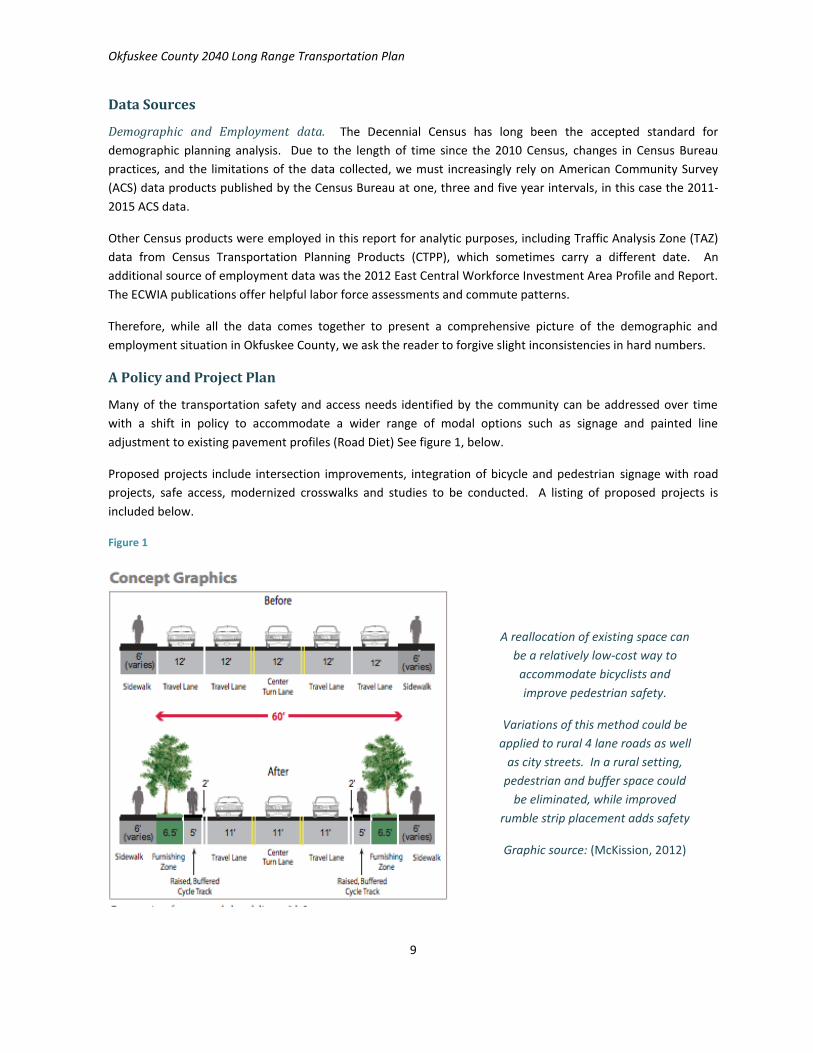
A Policy and Project Plan
Many of the transportation safety and access needs identified by the community can be addressed over time
with a shift in policy to accommodate a wider range of modal options such as signage and painted line
adjustment to existing pavement profiles (Road Diet) See figure 1, below.
Proposed projects include intersection improvements, integration of bicycle and pedestrian signage with road
projects, safe access, modernized crosswalks and studies to be conducted. A listing of proposed projects is
included below.
Figure 1
A reallocation of existing space can
be a relatively low-cost way to
accommodate bicyclists and
improve pedestrian safety.
Variations of this method could be
applied to rural 4 lane roads as well
as city streets. In a rural setting,
pedestrian and buffer space could
be eliminated, while improved
rumble strip placement adds safety
Graphic source: (McKission, 2012)

Okfuskee County 2040 Long Range Transportation Plan
10
Poor rumble strip placement
negatively impacts the utility of the
shoulder
Identified Project Locations
Community Comment Problem State Road
SH 27 underpass, under I-40 safety Too narrow for Peds and bikes SH 27 under I-40
Intersection of Woody Guthrie/Columbia St Problem intersection SH 27; 56; 62
Intersection of SH 62 & Boley Town exit Problem intersection SH 62
School crossing Date St and SH 27 Needs stoplight and/or crosswalk SH 27
I-40 ramps need stoplights (Okemah) Needs stoplight and/or crosswalk I-40 Ramp
Repave SH 56 thru town; Add crosswalks Surface repair & crosswalks SH 56
Add shoulders to the Highways Needs shoulders 2-lane no-shldr
SH 75 from Weleetka to I-40 Too narrow, needs shoulders SH 75
Bikes on SH 56; 27 & SH 9 Needs shoulders and signage SH 56; 27 & SH 9
Need an exit off I-40 at Mi 222, to hospital Improved access I-40
Road from Boley to Prague (SH 62) Maintenance & Preservation SH 62
SH 75 from Weleetka to I-40 Maintenance & Preservation SH 75
Section 26 on North side of 62 highway; dirt washed from the bridge
Maintenance & Preservation Bridge SH 62
Table 1
Rumble Strip Placement
In addition to providing enhanced safety at a relatively low cost, appropriate rumble strip placement adds
sustainability and resilience to the regional transportation system. FHWA has published guidelines for rumble
strip design. Placement on or near the right edgeline can provide additional seconds of warning to both drivers
and bicyclists traveling in the same direction that a vehicle has strayed over the edgeline. Proper placement of
rumble strips also provides a wider riding surface between the roadway and the unimproved roadside (ditch).
FHWA information and a graphic illustrating preferred placement of rumble strips is shown in Appendix 5.10.

Okfuskee County 2040 Long Range Transportation Plan
11
Chapter 1: Introduction; Key Issues & Goals
Background Information
REGIONAL TRANSPORTATION PLANNING ORGANIZATION
In June of 2006, Rural Planning Organizations of America (RPO America) was established. Rural Transportation
Planning Organizations facilitate local involvement in the statewide transportation planning process at the
regional level, provide technical assistance to local governments, and assist with public involvement in the
planning process and other tasks. Congress recognized the new national organization as “dedicated to
improving the planning and development of America’s rural transportation network.” The group supports the
coordination, management, and planning of national rural transportation systems, as well as the linking of rural
community economic development initiatives with state and local transportation programs.
The Oklahoma Department of Transportation worked with the Federal Highway Administration to allocate a
portion of the federal State Planning & Research (SPR) funding to the Oklahoma Association of Regional Councils
(OARC) to fund rural transportation planning projects. The Central Oklahoma Economic Development District
(COEDD) was selected to participate. Other participating Regional Councils of Governments are NODA, SWODA,
ASCOG and Grand Gateway
In October of 2009, the COEDD board created the Central Oklahoma Regional Transportation Planning
Organization (CORTPO) by Resolution #09-04. The CORTPO Region is composed of a seven county area, and
includes Hughes, Lincoln, Okfuskee, Payne, Pawnee, Pottawatomie, and Seminole Counties (Map 1). CORTPO
will develop transportation plans for each county, which will ultimately result in a Regional Plan. The region is
predominately rural, with the majority of the population being within the incorporated cities of Seminole,
Shawnee, Stillwater, and Tecumseh.
The development of this Long-Range Transportation Plan (LRTP) provides an opportunity for the community to
identify priorities for Okfuskee County in context of the greater CORTPO region.
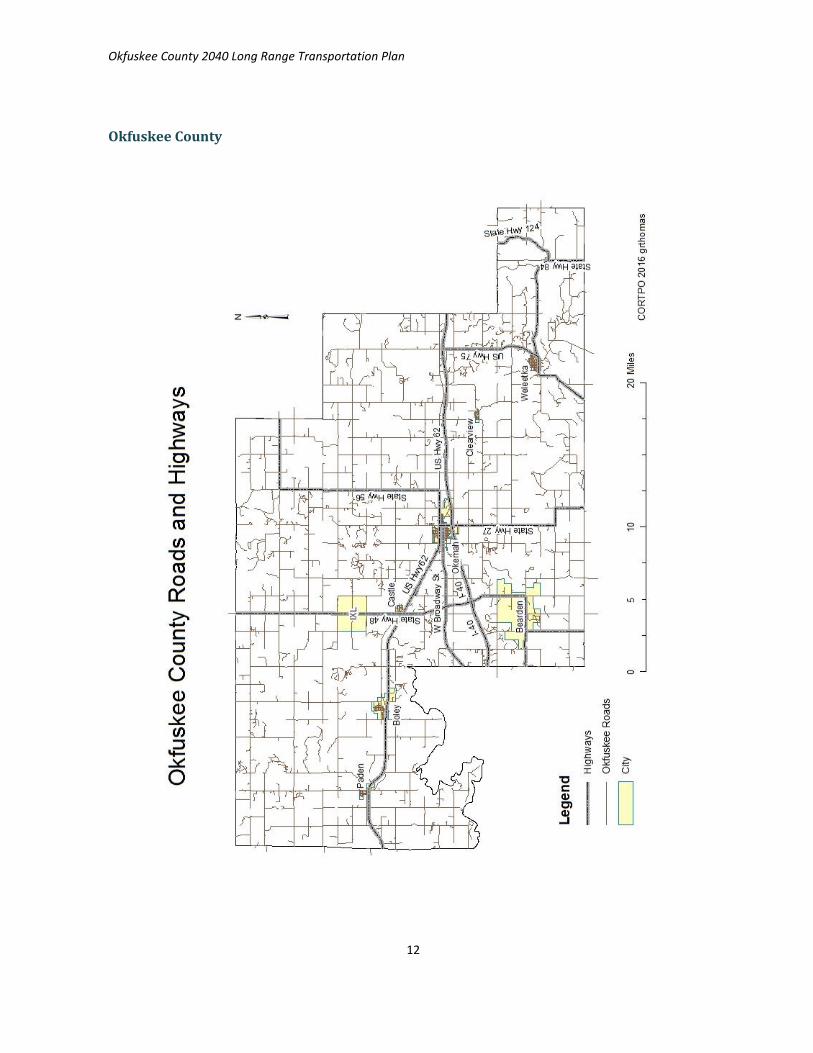
OKFUSKEE Major highways
Interstate 40
U.S. Highway 62
U.S. Highway 75
State Highway 48
State Highway 56
Okfuskee County 2040 Long Range Transportation Plan
12
Okfuskee County

Okfuskee County 2040 Long Range Transportation Plan
13
Purpose of the Plan
The Okfuskee County Long Range Transportation Plan (LRTP) may be used to assist the community in focusing
limited transportation funds on projects that provide the best return on investments, by developing realistic
goals based on analysis of data and input from the community. By establishing the year 2040 as the planning
horizon, the community is looking toward long range
strategies to accommodate community needs over a
significant period.
The transportation plan will provide a guide for the
development of a safer, more efficient transportation
network among population centers through both long-
term transportation system objectives and short-term
implementation of policies and projects. Realistic
assessment of short range steps toward long range goals
will support local fiscal planning and provide for long term
coordination with state or federally funded transportation
projects within the County.
Fixing America’s Surface Transportation (FAST) Act
On December 4, 2015, President Obama signed into law the Fixing America’s Surface Transportation Act, or
“FAST Act.” It is the first law enacted in over ten years that provides long-term funding certainty for surface
transportation, meaning States and local governments can move forward with critical transportation projects,
like new highways and transit lines, with the confidence that they will have a Federal partner over the long term.
More information about the FAST Act is available in Appendix 1.1
Requirements
The LRTP has been developed by CORTPO in cooperation with the federal, tribal, state, county, and member
governments, ODOT, FHWA and FTA. Federal requirements have been incorporated into the Okfuskee County
LRTP, some of which are reproduced below:
The transportation plan must
Address a twenty year planning horizon
Identify needed pedestrian walkway and bicycle facilities
Indicate, as appropriate, the transportation alternative activities within the area
Include a financial plan that demonstrates the consistency of proposed transportation investments
with sources of revenue already available
Planning Factors
The plan is intended to address the ten planning factors required by federal law 23 CFR 450.306 for the
transportation planning process listed in Table 2 on the following page.
Use the LRTP when:
Public repairs are planned, or
new development is proposed
Guiding Policy
Project List
Grant applications

Okfuskee County 2040 Long Range Transportation Plan
14
Planning Factors 23CFR 450.306
PLANNING FACTORS TO BE ADDRESSED IN NONMETROPOLITAN, METROPOLITAN
AND STATEWIDE TRANSPORTATION PLANNING:
1. Support the economic vitality of the United States, the States, nonmetropolitan areas, and metropolitan areas, especially by enabling global competitiveness, productivity, and efficiency.
2. Increase the safety of the transportation system for motorized and non-motorized users.
3. Increase the security of the transportation system for motorized and non-motorized users.
4. Increase accessibility and mobility of people and freight. 5. Protect and enhance the environment, promote energy conservation,
improve the quality of life, and promote consistency between transportation improvements and State and local planned growth and economic development patterns.
6. Enhance the integration and connectivity of the transportation system across and between modes, people and freight.
7. Promote efficient system management and operation. 8. Emphasize the preservation of the existing transportation system. 9. Improve the resiliency and reliability of the transportation system and reduce
or mitigate stormwater impacts of surface transportation 10. Enhance travel and tourism
Table 2

Okfuskee County 2040 Long Range Transportation Plan
15
Key Issues, Trends and Challenges
During the public participation process, the Okfuskee County community identified key issues, trends and
challenges that have an impact on the function of the transportation system.
Concerns of the community
Comments received during the public participation survey indicate that Transit is needed. Preservation of
existing infrastructure and road surface maintenance is a high priority in both the county road and city street
systems. Pedestrian routes to schools and shopping may be insufficient. There are few existing accommodations
for bicycle travel. Signage is perceived to be lacking or in need of repair.
Top Issues
Funding limitation. Revenues continue to be limited to meet transportation system needs,
while costs increase, especially for: County road maintenance, Transit, City street and sidewalk
maintenance, preservation and improvement, Bridge rehabilitation or reconstruction
Need for improved safety:
o Pedestrian access to common destinations and schools
o Increasing Bicycle traffic on rural roads
There is little resiliency and sustainability incorporated into the existing system
A need for improved: Local and regional transit, pedestrian, and bike accommodations,
signage, sidewalks, benches, bike racks;
Trends
Gradual population increase
An increase in the proportion of residents over age 65 is projected
Residents support local business and medical services
Decay of existing infrastructure among all modes of transportation
Increased Tribal influence on development and transportation in Oklahoma
A national and regional economic shift towards increased demand for recreational travel
amenities; Trails, sidewalks, bike racks, bike lanes
FHWA policy has placed greater emphasis on improving transportation for “traditionally
under-served” population groups such as:
o Non-drivers of any age, including the elderly, low-wage workers and zero-vehicle
households
o Bicycle and pedestrian users of the system

Okfuskee County 2040 Long Range Transportation Plan
16
Challenges
Funding
The primary challenge identified by this study is funding of all aspects of the transportation system. Revenue
has fallen behind the investment needed to preserve and maintain the current system, therefore, additional
funding will be needed to keep people and goods moving effectively over the next two decades. Increases in the
proportion of the population over age 65 can be expected to result in additional demand for transit. Regional
Rail service improvements would offer an alternative to trucked freight and reduce the wear on vulnerable state
and county roads. Funding for increased Transit, maintenance and preservation of the existing roads, bridges
and rail infrastructure must be the top priority of the long-range plan.
Maintenance and Preservation
COUNTY ROADS. The persistent challenge to the county road system is the
cost of road maintenance; the daily costs of keeping more than 800 miles of
roadway and signage in good condition.
SIDEWALKS AND PEDESTRIAN SAFETY. Sidewalks and proper crosswalks
throughout the region are absent or in a state of disrepair. The lack of safe
paths to shopping, school and recreation is a common safety issue. Some
Okfuskee County towns and cities have made efforts to improve pedestrian
conditions. These efforts should be continued and supported in every
population center.
RAIL. Some of the regional rail capacity has deteriorated to a point where the
infrastructure is nearly lost. A great deal of research has been completed that
demonstrates the value of rail infrastructure in central Oklahoma, and the direct
economic benefits of existing and potential rail restoration investment in
Okfuskee County and the CORTPO region. BNSF operates a rail line that passes
through Weleetka. The station is still listed on the BNSF website as active.
The following paragraph is excerpted from the Federal Highway Administration
document titled “Planning for Transportation in Rural Areas,” that are relevant
to Okfuskee County connections to the regional and national economy:
“Business decisions by rail companies have resulted in the abandonment of
many rural branch lines. The result has been loss of rail freight service to these
areas and increased trucking on the rural road system to compensate for this loss. Increased trucking on rural
roads ultimately increases road maintenance needs and reduces the financial capability of the rural area and
state to keep the roads in adequate condition. (FHWA PTRA, 2001)”
The reader is directed to the 2013 Oklahoma Rail Infrastructure Report Card; the 2012 Oklahoma Statewide
Freight and Passenger Rail Plan; current FHWA and ODOT policy, and other print and web resources.
General maintenance
and repairs are the key
factors in keeping
annual costs of road
work low. According to
the American
Association of State
Highway and
Transportation Officials
(AASHTO), every $1
spent to keep a road in
good condition avoids
$6-$14 needed later to
rebuild the same road
once it has deteriorated.

Okfuskee County 2040 Long Range Transportation Plan
17
Demographic Trends
STABLE POPULATION AND ECONOMY. Okfuskee County is forecast to have a relatively stable population
with a gradual increase over time. According to the public survey conducted in Okfuskee County, most people
work and shop within 30 miles of home.
AGING. The projected number of people over age 65 in 2040, is expected to grow. In 2015, Oklahoma was
home to more than 3.6 million people. Of these, more than 1 million (about 34 percent) were over age 50. In
2015, Okfuskee County, 16.7% of the population was over age 65, somewhat higher than the percentage for the
rest of the State (14.2%). The US Administration on Aging (AoA) Report projected that by 2030, the over-65
group will make up 24% of the population in the state (AoA, 2014). If the balance holds true, Okfuskee County
may expect an aging population in excess of 25% of population. For more information on changing
demographics in the county also see Appendix 3.2.
Projected trends: Aging population in Oklahoma
Year 2012 2020 2030
Age Group
0 to 19 27.70% 27.80% 27.80%
20 to 39 25.90% 25.00% 24.70%
40 to 59 26.40% 24.20% 23.10%
60+ 20.00% 23.10% 24.40%
Source: U.S. Census Bureau (AoA, 2014) Table 3
CULTURAL TRENDS AND PERCEPTIONS. “Quality of life” is an economic issue that impacts the long-term
social and fiscal health of a community. The availability of preferred educational, recreational and
transportation options has a direct impact on where individuals choose to invest valuable business and family
resources. Continuing efforts to develop the county as a great place to live and work is a fundamental
component of economic attraction, as is the physical appearance of the visible infrastructure.
Other challenges that were identified by this study:
There has been limited integration of alternative mode facilities, environmental or sustainable
transportation improvements within the current system
Safety and security for all legal road users has not been fully integrated into historic improvements
Improved integration of transportation goals with economic development goals could result in greater
efficiencies in fiscal investment
Barriers to accessibility and mobility for under-served segments of the community – including able-
bodied non-drivers – may have a negative impact on:
o the local economy (customer access, worker stability)
o perceptions of the quality of life available in Okfuskee County
o Community health, safety and welfare

Okfuskee County 2040 Long Range Transportation Plan
18
Goals, Objectives and Policies
The LRTP includes goals, objectives and policies to assist Okfuskee County in the planning and prioritization of
transportation system investments.
GOALS
The goals of the LRTP were developed from meetings held with the general public, key stakeholders, Technical
Committee members, Policy Board members and are based on the current planning guidelines published by the
primary funding agencies – the Federal Highway Administration (FHWA), and the Oklahoma Department of
Transportation (ODOT). We applied the acronym SMART as a template for development of the objectives.
OBJECTIVES
Objectives are specific, quantifiable steps towards the realization of community goals. Objectives should be
Specific and Measurable and are more focused; typically more tangible statements related to attaining the set
goals.
POLICIES
Policy statements and Action steps provide guidance for decisions that will help attain these goals and
objectives. They are Attainable and Relevant in the twenty-year Time frame. Policies included in the plan were
developed in coordination with member governments; partner agencies; technical committee and policy board
members and are based on the current planning policies of the FHWA and ODOT.
Okfuskee County Goals
Goals for the Okfuskee County LRTP were developed from comments received from the public and are based on
the ten planning factors required by federal law 23 CFR 450.306 for the transportation planning process. Table 4
identifies the goal categories for the LRTP. The full text of the goals, objectives and strategies developed for this
plan are outlined below.
Goal Categories
1. Maximize Access to Funding Provide a sound financial basis for the Transportation system
2. Prioritize Maintenance and Preservation
Maintain and preserve existing infrastructure and services
3. Enhance Economic Vitality Maintain and enhance movement of freight and other economic development activities; Improve quality of life
4. Improve Accessibility, Mobility and Connectivity
Improve accessibility and mobility of people and freight; Improve regional connectivity and continuity of roads, sidewalks, bike routes and rail
5. Increase Safety and Security Ensure high standards of safety in the transportation system, improve resilience for personal and economic security
Table 4

Okfuskee County 2040 Long Range Transportation Plan
19
Goals and Objectives
Goal 1– Maximize Finance & Funding
GOAL STATEMENT: A fiscally balanced and sustainable transportation system
Objectives
A. Consistent regional applications for all available transportation opportunities maximizes annual funding
B. Local agencies, municipalities, tribal governments, state officials and private interests effectively
collaborate in the pursuit and funding of transportation improvements
C. Expansion of transportation modes that utilize private funding or have a higher proportion of user-
borne costs, such as private roads and rail; fees for service
Goal 2 – Prioritize maintenance and preservation of existing infrastructure
GOAL STATEMENT: Preservation and maintenance of all components of the existing system will be prioritized
over new construction to serve residential and commercial development within the region.
Objectives
A. The current transportation system is maintained with stable funding
B. Regional pavements are preserved through growth of intermodal rail freight
C. New development is directed to appropriate roads and infrastructure
D. Private companies with heavy truck traffic contribute to maintenance of vulnerable county roads
Goal 3 – Enhance Economic Vitality
GOAL STATEMENT: An integrated, multimodal transportation system promotes quality of life and economic
development opportunities through enhancing the economic competitiveness of the region by improving access
to jobs, education services, encouraging healthy neighborhoods and supporting business access to markets.
Objectives:
A. Economic development is coordinated with strategic transportation investments
B. Employers have assurance that the labor force has reliable transportation options
C. Retail establishments are located within Town/City limits
D. Reliable access to shopping and services is realistic for all residents
E. Retail customers using all modes of travel are welcomed by Complete Streets
F. Tourism provides annual revenue dedicated to low cost transportation improvements

Okfuskee County 2040 Long Range Transportation Plan
20
Goal 4 – Improve Accessibility, Mobility, Connectivity
GOAL STATEMENT: Improve accessibility and mobility for Okfuskee County’s people and freight; Ensure
regional connectivity; Support multiple modes of transportation
Objectives
A. Funding is balanced among modes to ensure sustainable mobility solutions
B. Highway improvements are coordinated with other transit, bicycle and pedestrian projects and rail
facilities according to the policies of the 2015-2040 ODOT LRTP
C. Reliable access to the transportation system is ensured for disadvantaged persons
D. Transit is a preferred method of travel for a wider segment of the populace
E. Bike routes are indicated with signage for improved regional mobility
F. Park-and-ride lots are available in locations where potential ridership warrants
G. Planning efforts result in continuous bikeways throughout the multi-county region
H. Right of way (ROW) areas are preserved for transportation purposes; including abandoned, existing and
future road and railroad corridors
Goal 5 – Increase Safety & Security
GOAL STATEMENT: Safety: All modes of transportation will provide transportation opportunities that are safe.
Security: Identify and protect critical transportation infrastructure from both natural hazards and human threats;
incorporate strategies for improved resilience.
Objectives:
A. Areas with higher collision rates are monitored and improvements are implemented
B. Structurally deficient bridges are prioritized for repair or replacement
C. Local site development standards address safety for all legal road users
D. Bicyclists have improved safety in rural areas
E. Persons using handicap mobility vehicles have off road access to common destinations
F. Crosswalks have appropriate signage and visibility
G. A transportation system which is sustainable and resilient supports long term needs
H. Improved modal options reduce reliance on single-occupancy vehicles
See Chapter 1; Strategies for Implementation; Activity & Projects
Chapter 6, Recommendations; Implementation; Policies.
Policies Actions and Projects have been summarized into a single table for easy
reference in Appendix 6

Okfuskee County 2040 Long Range Transportation Plan
21
Chapter 2: Current Conditions, Needs, and Funded Improvements
This chapter provides an assessment of current conditions that relate to transportation in Okfuskee County.
Data and information included in this chapter were obtained from county, state and federal agencies or
institutions.
Okfuskee County
The following information is sourced from the Encyclopedia of Oklahoma History and Culture, by Linda Wilson:
The area now covered by Okfuskee County was occupied by the Quapaw and Osage tribes until 1825, when they
ceded the land to the United States government. After the Civil War, free African American Creek remained in
the area and founded all-black communities. These towns included Boley, Bookertee, Clearview, Chilesville, and
Rusk. Okfuskee, a Creek town, grew up around Samuel Checote's trading post after the Civil War. Okfuskee
County was created at statehood (1907) from the former Creek Nation, and Okemah was designated as the
county seat. Today, the County is entirely within the jurisdiction of the Muscogee Creek Nation. (Map,
Appendix 2.1.)
Oil and gas production began in the county in 1914, when the Prairie Oil and Gas Company completed a well
near Paden. Other wells followed elsewhere in the county, creating a population boom that peaked in 1930
(Wilson, 2009). According to the U.S. Census Bureau, the county has a total area of 629 square miles, of which
619 square miles is land and 10 square miles (1.6%) is water.
Ecology
The county lies within the Sandstone Hills physiographic region and the Cross Timbers ecological region. The
northeastern part is drained by the Deep Fork of the Canadian River, while the southern part is drained by the
North Canadian River.
Economy
Okfuskee County's historic economy has been based on the
petroleum industry, ranching and farming. In the early 1900s the
county had one-fourth of its surface covered with timber, and one-
half was under cultivation in the production of cotton, corn, oats,
hay, Kaffir corn (a predecessor of today's milo and grain sorghums),
and potatoes (Wilson, 2009).
Places
The county seat is Okemah. Other incorporated towns in the county
include Bearden, Boley, Castle, Clearview, IXL, Paden and Weleetka.
There are seven unincorporated communities; Last Chance, Mason,
Micawber, Morse, Okfuskee, Pharoah, and Welty.
Okfuskee County
Incorporated Municipalities
Population 2000 2010 Change
Bearden 140 133 -5%
Boley 1126 1184 5%
Castle 122 106 -13%
Clearview 56 48 -14%
IXL 59 51 -14%
Okemah 3038 3223 1%
Paden 446 461 3%
Weleetka 1014 998 -2% Table 5

Okfuskee County 2040 Long Range Transportation Plan
22
Population
As of the 2010 United States Census, there were 12,191 people residing in the county. The 2015 estimate is
12,248, consistent with gradual growth. In the county, the population was spread out with 24.6% under the age
of 18 and 16.3% who were 65 years of age or older. The median age was 40.5 years. The county enjoys a
relatively diverse population, with 64.4% of people identifying as White, 19.7% Native American, 8.3% Black or
African American, 0.2% Asian, 0.1% Pacific Islander and 6.5% of two or more races. 2.9% were Hispanic or Latino
(of any race). Therefore, Okfuskee County has more people who identify as Black and Native American, and
fewer Whites or Hispanics than does the state, in general.
2015 State of OK Okfuskee county
Race and Hispanic or Latino % %
Total population 100 100
One race 94.1 93.5
White 72.2 64.4
Black or African American 7.4 8.3
American Indian and Alaska Native 8.6 19.7
Two or More Races 5.9 6.5
Hispanic or Latino (of any race) 8.9 2.9
Table 6
(2015 US Census Data)
Households
There were 4,354 households, of which 29.2% had children under the age of 18 living with them, and 14.5% had
someone living alone who was 65 years of age or older. The average household size was 2.52. Eight percent of
the population in the county are housed in an institution; most are men at the John H. Lilley Correctional center
near Boley. There were 5,282 housing units, of which 928 are vacant (17.6) for a total of 4,354 occupied
dwelling units. Seventy-four percent 74.4% are owner occupied, 25.6% are rentals. Most vacant units are rental
properties. Okfuskee County Housing units Total: 5,282
Urban: 1,443 27%
Rural 3,839 73%
Occupied housing units 4,354 82%
Vacant housing units 928 18% Table 7
(2015 US Census Data)
Okfuskee County 2040 Long Range Transportation Plan
23
VEHICLES AVAILABLE
Occupied housing units 4354 # Hhd's # People
No vehicle 8% 327 833
Table 9
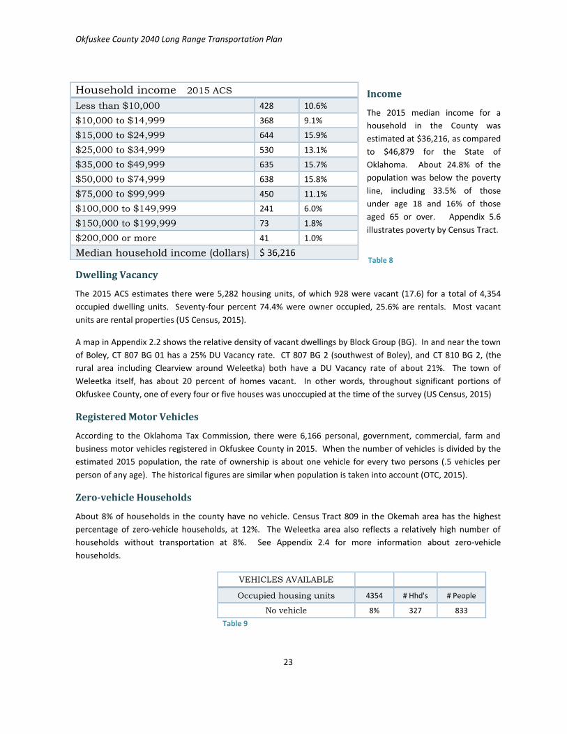
Income
The 2015 median income for a
household in the County was
estimated at $36,216, as compared
to $46,879 for the State of
Oklahoma. About 24.8% of the
population was below the poverty
line, including 33.5% of those
under age 18 and 16% of those
aged 65 or over. Appendix 5.6
illustrates poverty by Census Tract.
Dwelling Vacancy
The 2015 ACS estimates there were 5,282 housing units, of which 928 were vacant (17.6) for a total of 4,354
occupied dwelling units. Seventy-four percent 74.4% were owner occupied, 25.6% are rentals. Most vacant
units are rental properties (US Census, 2015).
A map in Appendix 2.2 shows the relative density of vacant dwellings by Block Group (BG). In and near the town
of Boley, CT 807 BG 01 has a 25% DU Vacancy rate. CT 807 BG 2 (southwest of Boley), and CT 810 BG 2, (the
rural area including Clearview around Weleetka) both have a DU Vacancy rate of about 21%. The town of
Weleetka itself, has about 20 percent of homes vacant. In other words, throughout significant portions of
Okfuskee County, one of every four or five houses was unoccupied at the time of the survey (US Census, 2015)
Registered Motor Vehicles
According to the Oklahoma Tax Commission, there were 6,166 personal, government, commercial, farm and
business motor vehicles registered in Okfuskee County in 2015. When the number of vehicles is divided by the
estimated 2015 population, the rate of ownership is about one vehicle for every two persons (.5 vehicles per
person of any age). The historical figures are similar when population is taken into account (OTC, 2015).
Zero-vehicle Households
About 8% of households in the county have no vehicle. Census Tract 809 in the Okemah area has the highest
percentage of zero-vehicle households, at 12%. The Weleetka area also reflects a relatively high number of
households without transportation at 8%. See Appendix 2.4 for more information about zero-vehicle
households.
Household income 2015 ACS
Less than $10,000 428 10.6%
$10,000 to $14,999 368 9.1%
$15,000 to $24,999 644 15.9%
$25,000 to $34,999 530 13.1%
$35,000 to $49,999 635 15.7%
$50,000 to $74,999 638 15.8%
$75,000 to $99,999 450 11.1%
$100,000 to $149,999 241 6.0%
$150,000 to $199,999 73 1.8%
$200,000 or more 41 1.0%
Median household income (dollars) $ 36,216 Table 8

Okfuskee County 2040 Long Range Transportation Plan
24
Traffic Analysis Zones (TAZ)
The Traffic Analysis Zone (TAZ) Program is used to produce Census
Transportation Planning Products (CTPP). TAZ data are based on the 2010
US Census and are designed to allow planning agencies access to specific
data for transportation system analysis and creation of geographic
information layers suitable for planning purposes.
CORTPO uses Traffic Analysis Zone (TAZ) boundaries in analysis of socio-
economic data. Geographically, the Census study area was subdivided into
five TAZ which (in Okfuskee County) were equivalent to the Census Tracts
(CT) (See Appendix 2.2) and numbered identically to the CT’s. One of the
tasks of this planning effort was to create more detailed TAZ, based on
census block data for the rural areas of the state. Census data is organized
by County, Census Tracts, Block Groups and the smallest units, Tabulation
blocks. Forty-two (42) TAZ were created based on block data, each with
populations numbering 200 to 400 people. See Appendix 2.3 for more
information.
Major Employers
Crop and cattle agriculture have long been important to the county
economy. Common agricultural products from the county today are sorghum, hay and cattle. Other crops have
been cotton, wheat, corn, oats, and soybeans. Small poultry and cattle operations are common. The primary
mode of transportation for shipping agricultural products into the national economy is by truck.
Okfuskee County is part of the East Central Workforce Investment Area (ECWIA). Most major employers are
located in or near the City of Okemah. The East Central Workforce Investment Area (ECWIA) monitors job data
for five counties: Hughes, Lincoln, Okfuskee, Pottawatomie, and Seminole counties. Okfuskee County represents
about 6.6% of ECWIA jobs.
Of nineteen top employers listed by the ECWIA, the largest employer is a prison, five are governmental bodies,
four are educational centers, and four are medical facilities. Two Casinos, two banks, a grocery store, and a
retail fast food restaurant all rank in the top nineteen with 25 to 50 employees each. (OKCOMM, 2011).
Therefore, it appears that the largest employers in the county are engaged in services for people, as opposed to
manufacturing or other industry, and much of the sales tax revenue is sourced from food sales and small retail
businesses of less than 25 employees each. See Table p. 27, below.
Commuter Statistics
According to the 2011 WIA Economic Profile, there are a significant number of people who commute to work.
For the most part, ECWIA workers live in the same county as their place of work. In Okfuskee County, 60% of
workers are employed within the county. About 13% commute to Pottawatomie, Lincoln, Seminole or Hughes
counties. Approximately 27% of working residents leave the ECWIA for employment; that percentage includes
workers commuting north or east, to neighboring counties. Of course, a number of workers also commute into
Okfuskee County from adjacent communities each day, resulting in a small net reduction in daytime population.
See Appendix 2.2 for more information.
Three hundred twenty-
seven (327) households in
the county have no
vehicle.
At an average household
size of 2.6 persons, that
means about
833 people have no
transportation at home
- uscensus ACS 2015

Okfuskee County 2040 Long Range Transportation Plan
25
Okfuskee County Major Employers
Department Of Corrections Boley 150-250 Government
Creek Nation Hospital Okemah 150-250 Medical
Okemah Public Schools Okemah 150-250 Education
Golden Pony Casino Okemah 100-150 Casino
Okfuskee County Okemah 50-100 Government
Muscogee Creek Nation/Casino Okemah 50-100 Tribal government/casino
Weleetka Public Schools Weleetka 50-100 Education
Okemah Care Center LLC Okemah 25-50 Sr. living center
Boley Residental Care Home Boley 25-50 Substance abuse treatment
City Of Okemah Okemah 25-50 Government
Paden Public Schools Paden 25-50 Education
Mason School District Mason 25-50 Education
Thlopthlocco Tribal Town Okemah 25-50 Tribal government
Stepping Stones Inc Boley 25-50 Medical
Okemah National Bank Okemah 25-50 Banking
Homeland Stores Okemah 25-50 Retail
Newton Investments Inc Okemah 25-50 Retail food
Citizens State Bank Okemah 25-50 Banking
Dept Of Human Services Okemah 25-50 Government
Table 10 (US Census Fact Finder, 2015)
Okemah Lake Recreation facilities
include: Tent and camper spaces,
14 hookups with
restrooms/showers, outdoor grills,
pavilions available for retreats and
family or church gatherings,
restrooms, a swimming area, a
playground for the kids, a boat dock
and boat ramps.

Okfuskee County 2040 Long Range Transportation Plan
26
County and Community Development
Changing land uses affect the flow of traffic throughout the community. Over recent decades, most residential
and industrial growth has occurred in and near incorporated municipalities. This is a preferred development
strategy which efficiently utilizes existing infrastructure.
Growth within the towns of Okemah and Weleetka is guided by Zoning. Okfuskee County itself has no zoning or
subdivision regulations; the county does regulate road standards for new development. Okemah is adjacent to
I-40, providing ready access for freight.
Some areas are common destinations that may generate additional demands on the transportation system.
Such activity-generators include grocery, retail, business and industrial sites, agencies, schools, universities, and
recreation centers. The destinations in the county that draw the most concentrated traffic are in Okemah; the
downtown, grocery and shopping strip. There is an industrial area on the east side of town.
In the aerial view of Okemah below, the light toned areas show the downtown area (which remains active) in
the picture center and the strip North and South along Woody Guthrie Street. This concentrated development
pattern is desirable to prevent infrastructure sprawl. However, sidewalks and crosswalks lack connectivity.
State Highway 27 (Woody Guthrie Street) passes through a school zone and an underpass, connecting to a
convenience store and Casino south of I-40. Pedestrians and persons using handicap-mobility vehicles must
cross through the narrow underpass to access the south part of the city. See photos page 27.
Light toned areas show commercial, retail and industrial structures and concentration of pavement

Okfuskee County 2040 Long Range Transportation Plan
27
PEDESTRIANS
“Pedestrian” is a term intended to include
both those who travel by walking and
people using wheelchairs or handicap-
mobility vehicles
Sidewalks lack connectivity along a commercial strip on State Highway 27, Okemah
Below: a narrow underpass places pedestrians in close proximity to vehicles. OK 27, on the south side of Okemah,
connects the main residential and shopping areas to convenience stores and casino under I-40
Okfuskee County 2040 Long Range Transportation Plan
28
Narrow passage
Physical Development Constraints, Development Conditions and Patterns
There are various factors that can affect whether a site is appropriate for development. Some of these
conditions may include the location of water and sewer infrastructure, existing roads buildings and, land
ownership and tribal jurisdictions, legally established rights of way,
floodplains, wetland areas, habitats or regulations.
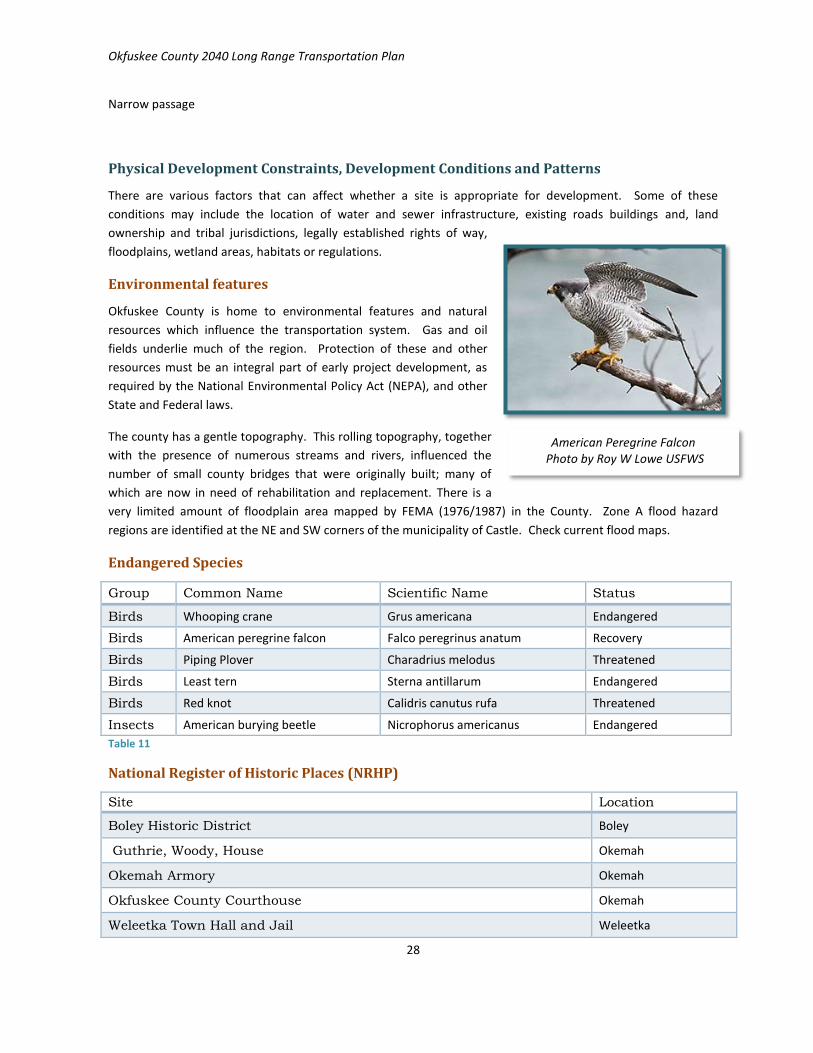
Environmental features
Okfuskee County is home to environmental features and natural
resources which influence the transportation system. Gas and oil
fields underlie much of the region. Protection of these and other
resources must be an integral part of early project development, as
required by the National Environmental Policy Act (NEPA), and other
State and Federal laws.
The county has a gentle topography. This rolling topography, together
with the presence of numerous streams and rivers, influenced the
number of small county bridges that were originally built; many of
which are now in need of rehabilitation and replacement. There is a
very limited amount of floodplain area mapped by FEMA (1976/1987) in the County. Zone A flood hazard
regions are identified at the NE and SW corners of the municipality of Castle. Check current flood maps.
Endangered Species
Group Common Name Scientific Name Status
Birds Whooping crane Grus americana Endangered
Birds American peregrine falcon Falco peregrinus anatum Recovery
Birds Piping Plover Charadrius melodus Threatened
Birds Least tern Sterna antillarum Endangered
Birds Red knot Calidris canutus rufa Threatened
Insects American burying beetle Nicrophorus americanus Endangered
Table 11
National Register of Historic Places (NRHP)
Site Location
Boley Historic District Boley
Guthrie, Woody, House Okemah
Okemah Armory Okemah
Okfuskee County Courthouse Okemah
Weleetka Town Hall and Jail Weleetka
American Peregrine Falcon Photo by Roy W Lowe USFWS

Okfuskee County 2040 Long Range Transportation Plan
29
Table 12
Bicycle and Pedestrian Network
The 2006-2010 American Community Survey showed that few people walked or rode bikes to work in Okfuskee
County. While the proportion of the pedestrian and biking public in addition to workers has not been
measured, it can be stated that those who prefer sustainable or healthy forms of transportation, low-income
workers, students and other diverse non-driver adults would benefit from increased safety.
Public Transit
Low population densities in the county and the distances between activity centers complicate the delivery of
public transportation in rural areas. There are activity generators including workplace, shopping or medical
destinations, which produce concentrations of transit need, where at least one end of a trip is concentrated
enough that public transit may be feasible. The challenge is to establish stable funding, design efficient routes
and schedule service such that the trip is attractive to the workers.
Ki Bois Area Transit (KATS) provides demand-response transit service for adults 18 years of age and older. The
transit program operates in Okfuskee County from 8:30 am to 4:00 pm Monday through Friday. The program
operates from schedules, and due to heavy demand, rides must be scheduled
well in advance of the need for service.
Highways
Interstate, US highways, State and county roads are the framework of
mobility. The location and condition of state highways in the county may
drive development decisions. Several two-lane no-shoulder roads in the
county are identified as locations for ODOT improvements over the next few
years. See Map Appendix 2.15. Most roads in Okfuskee County are two-lane
roads. Map 2: Okfuskee County Cities, Towns and Highways on Page 12
above, illustrates the location of local and state roads. Interstate highway I-
40 passes through the county. See Appendix 2.12 for Functional Classification
of roads; Appendix 2.13 shows Traffic counts.
Truck Freight
Reliable freight transportation enables connections among business and
markets in the County, in Oklahoma, the United States and the world
economy. According to the 2015 ODOT report titled Freight and Goods
Movement, freight activity has rebounded from an economic slump from
2008 to 2012, and is expected to continue to grow.
Highways are considered high volume truck corridors in locations where
roadways have consistent truck volumes at or above 5,000 vehicles per day,
or on facilities where truck traffic represents 40 percent or more of the total traffic. Interstate 40 is a high
volume truck route through Okfuskee County as identified by ODOT. State Highway 1 and SH 9 each carry
notable quantities of freight into, out of, and through Okfuskee County, as mapped by ODOT (ODOT FGM, 2015).
The 2012 ODOT
document Freight Flows
includes the following
comments about
trucked freight:
Almost two-thirds
(65%) of all trucks
traveling on the
Oklahoma highway
network have their
origin and destination
within the state.

Okfuskee County 2040 Long Range Transportation Plan
30
Rail
The location of rail facilities in the county may influence
development decisions. Connectivity of rail service in the CORTPO
region deteriorated after the peak of rail service in the early
twentieth century. In the last few decades, public and private rail
investments have been made to preserve lines and restore
service. See Appendix 2.9 for a map of railroad routes in Okfuskee
County. Burlington Northern-Santa Fe freight transport passes
through the southeast portion of the county. Additional
information is included in Appendix 2.8.
Rail Freight
Burlington Northern Santa Fe (BNSF) operates freight shipping in
Okfuskee County, passing through Weleetka. Freight movement
by rail reduces truck traffic on the state’s highways. One freight
train can carry the same tonnage of goods using less fuel, than
shipping by trucks. For that reason, shipping freight by rail also
reduces emissions per ton of freight.
Aviation
The county is home to Okemah Municipal Airport. The Creek
Nation Community Hospital operates a heliport for medical
emergencies. A Map in Appendix 2.9 shows Airport and Rail.
An operational BNSF freight route
passes through Okfuskee County as it
runs between Ada and Sapulpa
The orange line on the map indicates the operational BNSF line.

Okfuskee County 2040 Long Range Transportation Plan
31
Public Safety Issues
Transportation safety issues are based on a variety of factors, many of which cannot be addressed by local
transportation system planning, but are under ODOT jurisdiction. ODOT has collected extensive data and
identifies sites for improvements annually to improve safety conditions throughout the State.
The ODOT data in Table 2.1 depicts Okfuskee County Collision data from 2011 through 2015. There were a total
of 761 reported vehicle accidents of all types over the 5 year period between 2011 and 2015 (inclusive). The
number of all collisions per year has remained fairly steady since 2011 with a total of 156 crashes occurring in
2011, dropping to 135 in 2012, with 156 in 2013, 143 in 2014, and 171 in 2015.
In comparison, for the State of Oklahoma during this time period, total crashes declined by 14%, and fatal
crashes decreased by 14.5%. During the years 2011-2015, an average of two percent (2%) of Okfuskee County
accidents resulted in death. About 1% of all accidents statewide result in fatality. Sixteen (16) vehicle accidents
resulted in the deaths of 16 individuals in Okfuskee County over the five year period, 353 people were injured,
and 322 collisions caused property damage only.
Okfuskee County Collisions 2011-2015
Okfuskee County Collision data, by Year
Highway City Streets County Roads Total
Year Fat Inj PD Tot Fat Inj PD Tot Fat Inj PD Tot Fat Inj PD Tot
2011 3 38 58 99
4 17 21 1 17 18 36 4 59 93 156
2012 3 27 63 93
1 12 13
17 12 29 3 45 87 135
2013 2 36 83 121
2 5 7 2 16 10 28 4 54 98 156
2014 1 36 58 95
4 17 21 3 17 7 27 4 57 82 143
2015 1 39 86 126
2 15 17
11 17 28 1 52 118 171
Total 10 176 348 534 0 13 66 79 6 78 64 148 16 267 478 761
Table 13 Source ODOT 2015 The above information is for informational purposes only and use is restricted under 23 USC 409.
Most collisions and nearly all fatalities happen on highways in rural areas, including along I-40 (see Map 13,
Appendix 2). Of the 761 collisions that were analyzed for this plan, 534 (70%) were on highways. Nineteen
percent (148 collisions) occurred in rural non-highway areas; 10% (79) – including one fatality – were
documented on streets and highways within the city limits of Okemah; fifteen accidents (5%) occurred in Paden.
The remaining collisions happened within Boley, Castle or Weleetka, each recording three or four accidents over
a five year period.
More than 75% of collisions occurred during dry conditions; most happened during daylight hours in dry
conditions (47%). Accidents seem to be spread fairly evenly among the hours of the day with the exception of
peak traffic periods from 5 am to 8 am and from 4 pm to 6 pm. Friday was the most frequent day that accidents
occurred (18%), followed by Wednesday, Tuesday, then Saturday, Monday and Sunday. The fewest collisions
happened on Thursdays, at 12%, or 94 of all 761 accidents tracked.

Okfuskee County 2040 Long Range Transportation Plan
32
Causes
Many accidents have no specific cause noted (34%). The primary driver error identified was unsafe speed, the
cause of more than 18% of all collisions and 30% of fatalities. Following unsafe speed, about 15% of accidents
were caused by inattention; 7.4% were failure to yield; whereas drunk or impaired driving came in at 6.6% of all
causes of collision. Forty-four percent (7 of 16) of all fatal vehicle collisions were a result of collision with a fixed
object. Five (31%) fatalities occurred as a result of vehicle rollover.
Pedestrian; Bicycle
Of total collisions over the five year period, 2 of the persons killed and one injured were pedestrians. Only two
vehicle accidents involved bicyclists – one person was killed and one injured (.3% of total accidents).
Deteriorating Pavements and Deficient Bridges
Okfuskee County roads are rated as being in relatively poor condition. The Oklahoma DOT has assigned County
roads an average score of 110 on the International Roughness Index (2014), a measure of the pavement
performance standards for good and acceptable ride. A score below 95 is in the good category.
State transportation infrastructure investment did not increase between 1985 and 2005. According to the 2014
Update on Oklahoma Bridges and Highways published by ODOT, in 2005 highway pavements were deteriorating
at a rate beyond the available funding to repair, let alone reconstruct, and more than 1,500 of Oklahoma
highway bridges were structurally deficient or functionally obsolete (see Appendix C; Definitions).
The Oklahoma Legislature enacted legislation to begin to correct the problem. ODOT initiated a goal to have
near zero structurally deficient bridges in Oklahoma by 2020, and has replaced or rehabilitated more than 1,000
bridges since January 2006. All such bridges on State highways are targeted for repair and replacement by the
Oklahoma DOT over the next eight years. Therefore, much of the annual funding for road repairs and
improvements in the ODOT 8-year Plan (2015-2022) is necessarily dedicated to bridge work. See page 36,
below, for scheduled improvements in the ODOT 8-year Plan.
Bridges
Aging bridges are scattered throughout the
county. Structurally compromised bridges
may be weight restricted. Some bridges may
be structurally sound, but have narrow road
beds which are considered functionally
obsolete by modern standards.
The National Bridge Inventory tracks all bridges that are more than 20 feet long. The NBI database records a
total of 228 bridges in Okfuskee County. Of those, 114 are considered deficient or obsolete, most constructed
during the 1920’s and 1930’s. These bridges are identified and categorized by sufficiency rating in Appendix 3.8
Structurally Deficient; Functionally Obsolete
One hundred three (103) of Okfuskee County bridges are structurally deficient, 11 are functionally obsolete;
which can have a negative impact – not only on public resources and safety – but also on the development
potential of properties in the county. .
Okfuskee County Bridges on the NBI
Total Bridges # Structurally Deficient # Functionally Obsolete
228 103 11
Table 14

Okfuskee County 2040 Long Range Transportation Plan
33
A bridge is classified as structurally deficient if the deck, superstructure, substructure, or culvert is rated in
"poor" condition. A bridge can also be classified as structurally deficient if its load carrying capacity is
significantly below current design standards, or if a waterway frequently overtops the bridge during floods.
Functionally Deficient bridges have lane widths, shoulder widths, or vertical clearances that are not fully
functional to serve current traffic demand. While it is not unsafe for all vehicles, older design features cannot
adequately accommodate modern traffic volumes or vehicle sizes and weights.
In some cases, weight limits on county bridges may be too low to safely support
Fire response vehicles, resulting in a situation where trucks may have to be
indirectly routed in a fire emergency.
In the event of fire in a location that is not readily accessible to a fully loaded
water tanker, water may have to be shuttled across the bridge.
Structurally Deficient and Functionally Obsolete Bridge over Walnut Creek, Okfuskee County
Side View View from Road

Okfuskee County 2040 Long Range Transportation Plan
34
Chapter 3: Future Conditions, Needs, & Planned Improvements
Population and Employment Projections
US Census data indicate total population is expected to remain stable or slightly growing. Other demographic
factors remain stable.
Aging Population
The percentage of people in the general population from birth to adults age 44 has fallen, while the percentage
of population between 45 and 75 years of age increased significantly between the 2000 and 2010 Census.
While this change is not unexpected and is attributable to the aging status of people born during the post-WWII
population spike (Baby Boomers), this demographic group will likely include many additional non-drivers over
the next two decades. See Appendix 3.2.
Employment projection
The East Central WIA added +4,570 jobs between 2005 and 2010, growing by +7.1% over that time period.
ECWIA is projected to add jobs between 2010 and 2020. Agriculture leads expected job growth in Okfuskee
County, where farmers and ranchers are the fastest growing occupation, with farm managers and miscellaneous
agricultural workers also making the top ten.
Both collectively and individually, job growth for all five counties exceeded the state’s rate of job growth of
+6.0% between 2005 and 2010, with the lone exception being Okfuskee County. In Okfuskee County the net rate
of job growth was +1.5%. This was interpreted to indicate that while population in the county is stable, the rate
of job growth has remained positive. Therefore, the rate of employment was carried forward to project a
relatively stable employment situation through 2035.
Projected Growth Areas and new Housing
Residential, commercial and industrial growth is projected to continue to be concentrated in and near the Cities
of Okemah and Weleetka. Some smaller communities have set aside areas that are appropriate for Industrial
Park use. Each of these towns include housing which should be rehabilitated or demolished. Senior and Low-
income housing units would contribute to the vitality of these communities and meet the needs of retired
residents.
Highway improvements
Improvements planned for state roads in the county include upgrade of two-lane roads. ODOT has targeted
specific 2-lane roads for the addition of shoulders, to improve safety on these roads. A map illustrating the
location of these roads may be found in Appendix 2.15.
Bike and Pedestrian Routes
Pedestrian improvements have been initiated in the City of Okemah. The Town of Paden was awarded a TAP
grant in 2016 for construction and rehabilitation of sidewalks and trails. Anecdotally, the incidence of bicyclists
on both paved and gravel roads is increasing, consistent with national trends. There are no marked Bike routes
in the County, and currently, no such routes have been identified.

Okfuskee County 2040 Long Range Transportation Plan
35
Public Transportation
KATS transit consistently experiences high demand.
Survey results indicate regular riders of the transit service
are expressing a need for increased availability of trips,
shorter advance scheduling timelines and an option for
an interrupted trip (dropping a child off at day care on the
way to work). Transit systems may encounter increased
operational demand as the aging and low-income
populations continue to grow.
Rail Improvements
According to the 2010–2035 Oklahoma Statewide
Intermodal Plan, rail demand is expected to grow at a 0.9
percent annual rate from 2015 to 2035, with the largest
growth occurring on the Class I network in the center of
the State. The viability of the existing BNSF service
connecting Okfuskee County to the National Class I
system, may support the economic desirability of local
long-term rail improvements connecting freight to the
national system.
Projected increases in rail freight will influence the preservation, maintenance and restoration of the regional
rail infrastructure. Because public funding for transportation is so limited, it may be necessary to use
jurisdictional collaboration and private funding to stabilize and improve local railways.
Two at-grade Railroad crossings in Weleetka have been identified for improvement as part of a $100 million Rail
Crossings Safety Initiative was announced in 2014 by the State of Oklahoma and ODOT. These projects can
include improved signage and active warning systems such as flashing lights and gates that will lower to prevent
traffic from crossing when trains are present, and audible alert devices (ODOT, 2015).
Projected Freight Routes
The Federal Highway Administration‘s Office of Freight Management and Operations projects Oklahoma freight
tonnage to, from, within and through the state on all transportation modes to increase about 1.3% per year over
the 2015 to 2035 forecast period.
Highway freight tonnage is expected to increase its share of total freight tonnage from 51 percent in 2007 to 57
percent in 2035, driven mainly by strong growth in imports and exports. The State’s growth in exports is
expected to be concentrated in agricultural products, durable goods, and live animals. Freight tonnage is also
expected to grow fastest in areas of the State outside of the Oklahoma City and Tulsa Metropolitan Areas.
Annual truck traffic in Oklahoma on I-35, I-40, and I-44 is projected to grow at a 1.6-percent annual pace over
the 2015 to 2035 forecast period. By 2035, roughly 13,000 and 14,500 trucks per day are expected to use I-35
and I-40, respectively, throughout the State; and 8,500 trucks are expected to use I-44. This compares with
roughly 8,500, 9,500 and 5,300 vehicles in 2007. These forecasts further indicate an increase in truck traffic on
the smaller highways that connect with the interstate network as well (ODOT NHS, 2010).
Bicycle tourism is a growing segment of the economy
throughout the Midwest
“Gravel Grinders” is a local bike club whose members
enjoy long bicycle trips on regional gravel roads!

Okfuskee County 2040 Long Range Transportation Plan
36
Aviation Review
No airport improvements or expansions are planned at this time.
Funded Improvements; 8-year Plan
Funded improvements are projects that have ODOT and local funding commitments through the year 2018.
Projects included in the ODOT 8-year Construction Plan that are scheduled beyond a 3 or 4 year time frame are
subject to occasional reordering of priorities and funding has not been committed to those projects.

Okfuskee County 2040 Long Range Transportation Plan
37
County Improvements Roads & Bridges (CIRB)
Statewide, the CIRB 5 year plan includes replacement or rehabilitation of 439 County Bridges. This List includes
327 structurally deficient or functionally obsolete bridges. 52 Bridges in the CIRB plan are utilizing Recycled
Crosstown Bridge Beams. Approximately 875 miles of County Roads will also be improved.
County Improvements Roads and Bridges 2017-2020 Division 3 – Okfuskee
FY 2017
31151(06) CO BRGE
0.25 Mi RIGHT OF WAY
CO BR ON EW-113 OVER UNNAMED CREEK, 1.0 MILE EAST, 1.8 MILES NORTH AND 0.2 MILES WEST OF BEARDEN (ROW FOR J/P 31151(04))
$20,000 $20,000
31151(07) CO BRGE
0.25 Mi UTILITIES
CO BR ON EW-113 OVER UNNAMED CREEK, 1.0 MILE EAST, 1.8 MILES NORTH AND 0.2 MILES WEST OF BEARDEN (UTIL FOR J/P 31151(04))
$20,000 $20,000
FY 2018
30673(04) CO RD 7.00 Mi GRADE, DRAIN & SURFACE
GRADE, DRAIN AND SURFACE CO RD NS-377 BEG AT SH-56 EXTENDING NORTH 5.0 MILES TO EW-104 AND EW-102 BEG AT NS-377 EXTENDING EAST 2.0 MILES
$2,416,246 $2,416,246
31151(04) CO BRGE
0.25 Mi BRIDGE & APPROACHES
CO BR ON EW-113 OVER UNNAMED CREEK, 1.0 MILE EAST, 1.8 MILES NORTH AND 0.2 MILES WEST OF BEARDEN
$300,000 $300,000
FY 2019
30087(04) CO RD 5.00 Mi GRADE, DRAIN & SURFACE
CO RD, NS-383 BEG AT I-40 EXT SOUTH AND EAST TO NS-114 CLEARVIEW ROAD
$4,068,177 $4,068,177
FY 2020
No Projects scheduled in Okfuskee County FY 2020
Table 15
“The problems of 40 years of underfunding cannot be overcome in a few years,” said ODOT Executive Director
Mike Patterson. “ODOT is grateful to the Legislature and the public for investing in the system’s bridge needs.
Unfortunately, it will take a sustained effort to truly dig out of this hole and put Oklahoma back on track to
meets its citizens’ transportation needs.” (Hill, 2015)

Okfuskee County 2040 Long Range Transportation Plan
38
Chapter 4: Financial Summary
Funding for Projects and Recommendations of the LRTP
Funding of local transportation projects and programs is heavily influenced by State of Oklahoma’s annual
budget and federal funding. Transportation funding sources based on motor vehicle fuel taxes tend to fluctuate
with changes in fuel prices and fuel consumption. Instability in gas and oil revenues collected by the State has
contributed to the challenge of consistent investment in road surface maintenance and preservation. Modern
roads and bridges must be wider and carry more freight than the original design of a road, and therefore
rehabilitation or replacement becomes increasingly expensive.
Limited budgets and a focus on repairing structurally deficient bridges have diverted funds from pavement
maintenance. The number of structurally deficient highway bridges peaked at 1,168 in 2004. Due to increased
state funding since 2006, bridges were replaced at such a rate that by the end of the 2014 inspection season
that number had dropped to 372.
Therefore, coordination among federal, local, regional and statewide agencies in the development of
transportation initiatives will be necessary in order to accomplish needed improvements. New sources of
revenue may be required to meet gaps in services.
Funding Sources
Funding for highway improvements in Oklahoma comes primarily from two sources – the Federal Highway Trust
Fund and state funds. Oklahoma Department of Transportation (ODOT) provided $26 million of Surface
Transportation Program (STP) federal funds to the County Highway System. Oklahoma’s primary sources of
funding for road and bridge construction and maintenance are derived from fuel taxes and motor vehicle tax.
Appendix 4.1 provides more information about various transportation funding strategies.
In 1923, Oklahoma enacted its first State excise tax on motor fuels. The last increase was in 1987 and the tax is
currently 17 cents per gallon for gasoline; diesel is taxed at 14 cents. In addition, counties raise their own
revenue sources to supplement state and federal funding through local option sales taxes. Okfuskee County
collects a one-cent excise (sales) tax, the proceeds of which are deposited to the county revolving fund. Fifty-six
percent (56%) of the tax is allocated to maintenance, repair and improvement of county roads and bridges.
Rural Transit
The Federal Transit Authority allocates funds annually to the governor of each state, to provide funding for
public transportation projects serving areas that are outside of an urban boundary with a population of 50,000
or less. Tribal Transportation funding is a critical component of keeping transit available in the county and the
region.
Non-motorized Transportation
The Transportation Alternatives Program (TAP) was authorized under Section 1122 of Moving Ahead for
Progress in the 21st Century Act (MAP-21). TAP provides funding for programs and projects defined as
transportation alternatives, primarily bicycle and pedestrian infrastructure.

Okfuskee County 2040 Long Range Transportation Plan
39
Tribal Transportation projects and funding
Recognized tribal governments receive federal transportation funds and may also designate local funds for
transportation projects. Municipal and Tribal governments throughout the CORTPO region have been successful
in working together to achieve implementation of critical transportation improvements. The (TTP) Tribal
Transportation Program is the largest program in the Office of Federal Lands Highway. TTP is intended to
address transportation needs of Tribal governments throughout the United States. Okfuskee County is located
entirely within the Muskogee Creek Nation.

Okfuskee County 2040 Long Range Transportation Plan
40
Chapter 5: Public Participation
Public involvement is an integral part of the transportation process and is also a federal requirement, continued
as part of the legislation Fixing America’s Surface Transportation Act, or “FAST Act.” The Okfuskee County Long
Range Transportation Plan (LRTP) is the product of comprehensive study of data, community meetings, public
surveys and planning research. Together, these efforts provided an opportunity for local stakeholders to assess
the existing transportation system, consider needs, trends and alternatives, and identify specific priorities for
the county and region in the context of sound planning principles.
We include an assessment of the relative concentrations of identified populations such as low-income and zero-
vehicle households. Proposed construction projects must be evaluated to determine if they have
disproportional adverse effects on vulnerable populations. This concept is known as Environmental justice.
Additional information about community involvement in drafting this plan is available in Appendix 5.
Public Participation Plan
CORTPO is proactive in its efforts to communicate effectively with the public and has adopted a Public
Participation Plan (PPP) to ensure that local transportation planning provides opportunities for the public to take
an active role in the decision-making process and complies with the federal requirement for public involvement
and participation.
Methods
As part of the PPP, public meetings were held and newspaper press releases were issued for public outreach, to
involve interested parties in the early stages of the plan development. Notices of public meetings for the LRTP
were posted in accordance with Oklahoma Open Meetings Law After the draft LRTP was developed, CORTPO
hosted additional public meetings and provided a notice of availability for a 45-day public comment period
(Appendix 5.5; copy of public comment period notice). The final draft LRTP was presented to the CORTPO
Technical Committee for review and comment prior to recommendation to the CORTPO Policy Board for
adoption. Contact the CORTPO office or website for the full version of the PPP.
Surveys
To receive public comments by survey, we issued a press release, posted notices, published the survey on
CORTPO website, provided paper copies to local interest groups and distributed them throughout Okfuskee
County, the Towns of Paden, Boley, Clearview, Weleetka, City of Okemah, and community representatives on
the CORTPO Technical Committee. Surveys were collected from the public between January 10, 2017 and May
5, 2017. Thirty-two surveys were returned and tabulated. All public comments received have been included.
See Appendix 5.1 for survey instrument, response summary and public comments.
Narrative Survey Results
Three top concerns were identified during the process of public involvement. They are: Maintenance of
infrastructure, Improved Mobility (Transit and Pedestrian safety) and Economic Vitality. Road surface
maintenance and bridge integrity are considered most important for state and county roads, and city street
systems. Expanded transit and safer pedestrian routes and crosswalks are needed to access work, schools and
shopping. Economic vitality and transportation are viewed as mutually dependent. Signage is perceived to be
lacking or in need of repair. There are few existing accommodations for bicycle travel.

Okfuskee County 2040 Long Range Transportation Plan
41
Medical Travel
Many people are able to get primary medical care within 15 to 40 miles from home, in Okemah, Okmulgee,
Prague, Seminole or Shawnee, but that does represent a 30 to 80 mile round trip. A third of respondents must
travel to Oklahoma City for Medical care, often more than 150 miles round trip. Medical travel to OKC for
individuals varies from twice a week to 2 times per year among Okfuskee County respondents.
Work, Shopping, Other
Most respondents shop at local merchants most often (less than 30 miles from home) a 20 to 60 mile round trip.
The most frequent work and shopping destinations are Okemah, Prague, Shawnee and Oklahoma City. More
than half of respondents drive somewhere in a car alone every day (work, shopping, school). About a third of
respondents say that carpooling is common mode of travel. Few respondents report using transit services; one
respondent relies on a motorized wheelchair or scooter to access needed supplies or services in town.
Importance of transportation components
Road improvements and maintenance are viewed as the most important issues, followed by bridge
maintenance. Crosswalks, pedestrian safety and signage all rated as important concerns as well. Protecting the
environment ranked near the middle in importance, transit scored next, while bicycling and rail freight scored
much lower. All three modes (transit, bicycling and improved rail freight) could be viewed as environmentally
preferable to an individual vehicle strategy. This may indicate that bicycling and rail freight are seen as less
feasible than automobile travel.
Culturally, bicycling has been viewed as a relatively exotic method of travel in central Oklahoma. The proportion
of people engaging in bicycle recreational travel has been increasing in the region, consistent with a national
trend towards biking. While bicycle improvements scored lower than road maintenance and pedestrian
improvements, the higher priorities of general road safety (adding shoulders and improved signage) will support
an increase in bicycling as a viable and sustainable strategy for both travel and recreational purposes.
Anecdotally, bicycling was seen as being tied to economic vitality, tourism and perceived quality of life available
in the county, but may be viewed as a luxury in terms of
funding.
Priority for consideration
Economic development ranked as the top priority for
transportation improvements. This seems practical when
sales tax revenues and jobs are the revenue foundations for
local municipal functions.
Pedestrian safety was the second priority, followed by
more travel choices (transit) and reducing environmental
impacts.

Okfuskee County 2040 Long Range Transportation Plan
42
Environmental Justice
Public involvement in development of the Plan must comply with Presidential Executive Order 12898,
Environmental Justice. The Federal Highway Administration (FHWA) also follows federal policy to ensure
federally funded activities (including planning, through implementation) do not have a disproportionate adverse
effect on disadvantaged populations.
Poverty rates as defined by the U.S. Census Bureau ACS 2011-2015 were identified in Okfuskee County. About
18.8% of families and 24.8% of individuals were living below the poverty line. The LRTP process identified
additional environmental justice (EJ) populations through a comparison of the racial and ethnic composition of
the county by Census area. A greater percentage of minority populations do seem to be correlated with higher
density of poverty in the county. This information is further illustrated in Appendix 5.10.

Okfuskee County 2040 Long Range Transportation Plan
43
Chapter 6: The Transportation Plan
The recommendations of projects, plans, policies and studies were developed as a result of the review of
demographics, growth, activity generators, transportation infrastructure, survey information and comments of
the community. Research is included in the plan that will provide information and data to support achievement
of the goals. The goals, objectives, and recommendations of this plan can be used as guidelines for
improvement to the county and region’s multimodal transportation system over a long period of time.
With regard to Federally-funded projects, the Okfuskee County LRTP is fiscally balanced in that the total project
costs do not exceed the anticipated Federal funds. This assumes that Congress, at a minimum, will fund the most
conservative of the Federal reauthorization bills each cycle.
Clearview Road is slated for repairs on the 2019 CIRB plan. Five miles of road from the intersection of I-40, southeast to E114 must be rehabilitated, including
grade, drain and surface, at a cost of over $4 million. See Appendix 3.7 for a Table of other CIRB Projects

Okfuskee County 2040 Long Range Transportation Plan
44
LRTP Recommendations:
The goals and objectives in Chapter 1 of the Okfuskee County LRTP suggest strategies which consistently applied,
can be expected to bring the community vision to fruition. Those activities and policies have been organized
into a Table for handy reference below. The entire plan has been summarized into a comprehensive reference
Table shown in Appendix 6, The Plan.
CORTPO will continue to monitor potential funding sources as they become available, or as projects become
eligible. Over the life of the LRTP, Okfuskee County and CORTPO will expand on this effort by identifying
additional projects that are needed in the county and potential funding sources for those projects.
Comments Summary
The LRTP goals, objectives, policy and project suggestions are based on public comments. The largest number of
comments indicated a need for improved access and mobility specifically, additional transit, surface
maintenance and preservation of roads and bridges and improved safety for pedestrians. Specific locations
were noted where safety was a concern. Many of these locations are on State Highways. Those comments were
organized into Table 1, page 10, above. All comments received may be viewed in Appendix 5.5.
Community Survey project recommendations
There were several projects that were identified by the community during the planning process. Many
comments indicated a need for increased preservation and maintenance of existing road and street surfaces
throughout the county, and especially in small towns. Other projects suggested were crosswalks to improve
safety near schools and pedestrian improvements throughout the county. Rehabilitating the appearance of
public spaces and streets was suggested as pertinent to economic vitality and tourism. Improved bicycle safety
was of interest to the public.
Projects recommended in the LRTP are shown in Table 1 Chapter1. Potential funding may come from a single
source or multiple sources. Sources could include funding from entities such as EDA, USDA, REAP, CDBG,
Industrial Access, Lake Access, the Transportation Alternative Program (TAP) or the Tribal Transportation
Program (TTP). Additional sources of project support such as private investments, non-governmental grants and
others not listed may also be available. Successful projects are often the result of collaborative funding
strategies.
In Okfuskee County, and throughout the
CORTPO region, people using handicap-
mobility vehicles may be forced onto State
Highways when travelling from a
residential area to a grocery store or other
destination

Okfuskee County 2040 Long Range Transportation Plan
45
Strategies for implementation: Policy
Reference Policy Table:
Goal 1 Funding
1.1 Preservation of existing levels of service among all modes of travel is the first priority
1.2 Continue to expand Multi-jurisdictional collaboration
1.3 Allocate an annual portion of public employee labor to be used as in-kind funds for grants
Goal 2 Preservation & Maintenance
2.1 Coordinate with State and Federal agencies to stabilize funding; ensure that current levels of service on
roads, rail and transit systems, do not fail
2.2 Consistent investment in alternative modes to improve resilience
2.3 Use public-private agreements to maintain vulnerable county roads
Goal 3 Economic Vitality
3.1 Support facilities and services that enable non-drivers to access typical destinations
3.2 Coordinate economic development with long-term regional connectivity and sustainability
Goal 4 Accessibility; Mobility; Connectivity
4.1 Recognize and respond to opportunities to include pedestrian and bicycle infrastructure on or adjacent to
state routes
4.2 Choose transit when possible to support sustainability
4.3 Integrate alternative transportation solutions into all new developments
Goal5 Safety& Security
5.1 Well lighted facilities for automobile parking areas, bicycle and pedestrian facilities
5.2 Promote the use of alternative modes of transportation to reduce dependency on single-occupancy
vehicles;
5.3 Incorporate sustainability and resiliency into annual transportation projects to mitigate the economic
impacts of unpredictable events
Table 16

Okfuskee County 2040 Long Range Transportation Plan
46
Strategies for Implementation: Activity & Projects
Project activity Tables:
Goal 1 Funding
A.1.1 Monitor and apply for all available transportation grant opportunities each year
A.1.2 Engage in long term Fiscal Planning to balance long-term transportation needs with
sustainable solutions
A.1.3 Explore and implement alternative funding opportunities used in other jurisdictions
Goal 2 Preservation & Maintenance
A.2.1 Identify preferred development corridors and plan for preservation; Map
A.2.2 Evaluate and post weight limits on roads
A.2.3 Develop long-term strategies in coordination with waste disposal and oil field
companies to fund
Goal 3 Economic Vitality
A.3.1 Publish a County map showing the location of existing infrastructure appropriate for
residential and industrial development
A.3.2 Develop a prioritized plan for sidewalks and bicycle routes
A.3.3 Encourage Tourism with highway signage; earmark revenue for transportation
Goal 4 Accessibility; Mobility; Connectivity
A.4.1 Identify and minimize transportation barriers for non-drivers
A.4.2 Designate specific areas as Park-and-Ride lots for commuters
A.4.3 Develop a proposed Bike route map with a focus on regional connectivity
A.4.4 Add signage to direct Bike and Pedestrian travelers to preferred routes
A.4.5 Plan and implement walkways and bike facilities in small town areas
A.4.6 Evaluate existing town sidewalks and pursue rehabilitation
A.4.7 Appoint an individual to act as a Railroad contact to improve industrial access to rail
and facilitate the mobility of freight
Table 17
Projects, Continued . . .

Okfuskee County 2040 Long Range Transportation Plan
47
Goal 5 Safety & Security
A.5.1 Prioritize bridge improvements where weight limits are too low for emergency vehicle
response;
A.5.2 Map appropriate routes for tanker response according to bridge sufficiency ratings
(see Appendix 3.8)
A.5.3 Improved signage: alert motor vehicles to watch for bikes on the road
A.5.4 Evaluate and prioritize crosswalks for improvement
A.5.5 Place rumble strips appropriately for enhanced safety between motorized vehicles and
bikes using the shoulder in accordance with FHWA standards (see Appendix 5.10)
A.5.6 Use signage to alert motorists to the possible presence of bicycles on the road
A.5.7 Evaluate and prioritize underpasses and overpasses for low-cost improvements for
non-motor vehicle travel safety
A.5.8 Incorporate sustainability and resiliency into transportation system projects to
mitigate the economic impacts of unpredictable events
The Okfuskee County LRTP 2040 is organized in a Summary Reference Table format with policy
and action steps are shown together the goals and objectives for the convenience of the reader, in
Appendix 6.1
The CORTPO Staff appreciates the invaluable contributions offered by the citizens of Okfuskee County in the
development of this comprehensive Transportation policy plan.

Hughes County Long Range Transportation Plan2016-2040