Ohio Mussel Survey Protocol - United States Army
45
1 Ohio Mussel Survey Protocol April 2016 Ohio Department of Natural Resources (ODNR), Division of Wildlife and U.S. Fish and Wildlife Service (USFWS), Ohio Ecological Services Field Office Introduction All native mussels are protected in the State of Ohio (Section 1533.324 of the Ohio Revised Code). In addition, ten federally listed species occur in the State and are protected by the Endangered Species Act (87 Stat. 884, as amended; 16 U.S.C. 1531 et seq.). Impacts to State and federally protected mussels and their habitats should be avoided and minimized to the maximum extent practicable. If impacts cannot be avoided, all streams which contain mussels or potential mussel habitat must be surveyed prior to any proposed stream disturbance. When any survey criteria cannot be met, additional consultation with the appropriate State or Federal agency will be required. As a general reference for mussels in Ohio, please refer to The Freshwater Mussels of Ohio (Watters et al. 2009). As such, the protocols herein are designed to determine the presence or probable absence of federally listed mussel species (FLS) as well as provide for the protection of all native mussels within Ohio. Furthermore, this protocol will help assess the size of mussel populations within the project area. These protocols were developed to provide standardized guidance to project applicants about acceptable survey methods and levels of effort for a variety of common project types. These protocols are adapted for Ohio from “West Virginia Mussel Survey Protocols, April 2015, by Clayton et al.” These protocols are generally applicable to all rivers, streams, and Lake Erie that may harbor mussels. This protocol is divided into four sections: A) General Guidelines, B) Stream Group-specific Considerations, C) Relocations, and D) Project-specific Considerations. A) General Guidelines Stream Classification: Survey protocols in this document are based, in part, on stream size and the potential presence of FLS. Accordingly, for purposes of determining survey effort and protocols, Ohio streams have been divided into the five categories listed below (Appendix A). Appendix A will be updated as new location and mussel data information becomes available so please check the ODNR Division of Wildlife website for the latest information http://wildlife.ohiodnr.gov/licenses-and-permits/specialty-licenses-permits
Transcript of Ohio Mussel Survey Protocol - United States Army

1
Ohio Mussel Survey Protocol
April 2016
Ohio Department of Natural Resources (ODNR), Division of Wildlife and
U.S. Fish and Wildlife Service (USFWS), Ohio Ecological Services Field Office Introduction All native mussels are protected in the State of Ohio (Section 1533.324 of the Ohio Revised Code). In addition, ten federally listed species occur in the State and are protected by the Endangered Species Act (87 Stat. 884, as amended; 16 U.S.C. 1531 et seq.). Impacts to State and federally protected mussels and their habitats should be avoided and minimized to the maximum extent practicable. If impacts cannot be avoided, all streams which contain mussels or potential mussel habitat must be surveyed prior to any proposed stream disturbance. When any survey criteria cannot be met, additional consultation with the appropriate State or Federal agency will be required. As a general reference for mussels in Ohio, please refer to The Freshwater Mussels of Ohio (Watters et al. 2009). As such, the protocols herein are designed to determine the presence or probable absence of federally listed mussel species (FLS) as well as provide for the protection of all native mussels within Ohio. Furthermore, this protocol will help assess the size of mussel populations within the project area. These protocols were developed to provide standardized guidance to project applicants about acceptable survey methods and levels of effort for a variety of common project types. These protocols are adapted for Ohio from “West Virginia Mussel Survey Protocols, April 2015, by Clayton et al.” These protocols are generally applicable to all rivers, streams, and Lake Erie that may harbor mussels. This protocol is divided into four sections: A) General Guidelines, B) Stream Group-specific Considerations, C) Relocations, and D) Project-specific Considerations.
A) General Guidelines Stream Classification: Survey protocols in this document are based, in part, on stream size and the potential presence of FLS. Accordingly, for purposes of determining survey effort and protocols, Ohio streams have been divided into the five categories listed below (Appendix A). Appendix A will be updated as new location and mussel data information becomes available so please check the ODNR Division of Wildlife website for the latest information http://wildlife.ohiodnr.gov/licenses-and-permits/specialty-licenses-permits

2
Unlisted: Streams not listed in Appendix A with watersheds >10 mi2 with the potential for mussels but FLS not expected.
Group 1: Small to mid-sized streams, FLS not expected.
Group 2: Small to mid-sized streams, FLS expected.
Group 3: Large Rivers, FLS not expected.
Group 4: Large Rivers, FLS expected. Reconnaissance of Group 1 streams and Unlisted streams with a drainage area over 10 mi2 may be assessed using the Reconnaissance Survey for Unionid Mussels (Appendix B) to determine if mussels are present. The results of the reconnaissance survey will be sent to the ODNR Division of Wildlife Contact (Appendix C). The mussel habitat assessment using the Ohio Mussel Habitat Assessment Form must be conducted by someone that has met the minimum qualifications as described in Appendix D. If after review by ODNR it is determined that mussels are not present in the study area, then no mussel survey will be required. If it is determined that mussels are present, then the Ohio Mussel Survey Protocol will be followed. You may forgo a reconnaissance survey and conduct a full mussel survey as described below if desired. All Group 2, 3, and 4 streams require a mussel survey as described below. See USGS site for watershed size tool: http://water.usgs.gov/osw/streamstats/ohio.html Project Justification: Various laws, regulations, and policies require that impacts to aquatic resources, including freshwater mussels and endangered species, be avoided and minimized to the maximum extent practicable. For example, Clean Water Act 404(b)(1) Guidelines state that “no discharge of dredged or fill material shall be permitted if there is a practicable alternative to the proposed discharge which would have less adverse impact on the aquatic ecosystem.” The Guidelines further specify that the evaluation of practicable alternatives should include alternative construction methods that do not involve dredge or fill material into waters of the U.S. and alternative locations including “areas not presently owned by the project proponent but which could reasonably be obtained, utilized, expanded or managed in order to fulfill the basic purpose of the proposed activity” (§ 230.10 (a)(2)). The General Conditions that apply to all nationwide permits in Ohio also specify that “no activity may occur in areas of concentrated shellfish populations,” unless the activity is related to various shellfish harvesting or restoration activities. The Endangered Species Act, through the section 7 consultation process, requires that Federal agencies and their permit applicants consult with the USFWS to identify and implement measures to avoid or minimize adverse effects to listed species, prior to issuing any permits for the incidental take of listed species.
Project proponents can frequently save time and money, and avoid delays in their project permitting by developing project alternatives early in their planning process. In addition, during previous project consultations involving impacts to mussel populations, the USFWS and ODNR have found that practicable alternatives to avoid and minimize impacts can be developed for almost all projects.
Avoidance: Accordingly, to ensure that projects are implemented in a manner consistent with these regulations and to minimize project delays, all survey proposals submitted to the USFWS and ODNR should include evidence that avoidance is not possible and also address potential alternatives. Survey permits may not be approved if the applicant does not provide adequate justification that instream impacts cannot be avoided. Discussion of alternatives and how

3
impacts will be avoided and minimized shall be included in the scope of work if the applicant wishes to proceed directly from a Phase 1 to a Phase 2 survey.
Alternative Construction Methods: Projects should first be designed to avoid and minimize impacts to waters of the U.S. including impacts to streams containing mussel populations. For example, where possible, road crossings should be designed to completely span streams containing mussels. Routes for pipelines should be designed to avoid crossing streams containing mussels and minimize the number of stream crossings.
Activities such as pipeline/waterline crossings shall address alternative methods such as horizontal directional drilling (HDD). Using HDD practices shall be the first priority over open trenching to avoid impacts to mussels and avoid habitat degradation and fragmentation. A response plan for an inadvertent release shall be provided along with a notation on the potential for such an event. If HDD are not being proposed, documentation as to why this alternative is not practicable should be provided. This documentation should include detailed information on project constraints, and engineering and/or geologic evaluations sufficient to justify why this construction method cannot be implemented or would have a high likelihood of failure.
Alternative Locations: Moving project locations slightly upstream or downstream or making minor modifications to project designs is often sufficient to avoid and minimize impacts to mussel populations including endangered species and may allow projects to proceed with minimal delays. Any project that has potential alternative locations for activities (example bridge alignments, pipeline crossings) should include surveys for alternative locations. We recommend a phased approach to prioritize sites with follow-up surveys within the least impacting project site selected. All proposals shall include surveys areas large enough to include all alternative locations. Surveyor Qualifications: For Group 1 and Group 3 streams, surveyors must pass the Standardized Freshwater Mussel Identification Test (Appendix E) administered by The Ohio State University’s Museum of Biological Diversity (Contact in Appendix C) and have the minimum qualifications described in Appendix D. A Federal permit from the USFWS is required to conduct surveys in streams that may harbor FLS (Groups 2 and 4). Prior Notification: Even though standardized protocols are established, survey plans must be provided to appropriate State (all streams) and Federal (Group 2 and Group 4 streams) agencies. This is to ensure that the appropriate protocol is being applied for the given stream type and construction activity and to allow time for agency staff to review existing data from the proposed survey area and work with the applicant to design the appropriate survey extent as described below. Appropriate State and Federal agencies shall be notified at least 15 days prior to the time the actual survey will occur, and be given at least 30 days to review survey results prior to the anticipated start of any construction activities. State and Federal contact information is provided in Appendix C. Activities to be conducted in Group 2 or Group 4 streams must have received written concurrence from the USFWS prior to conducting any project activities including surveys, relocations and/or construction activities.

4
Survey Season: The survey season is from May 1 to October 1. Requests to conduct surveys outside this time period will be reviewed on a case-by-case basis, and will be approved only under extenuating circumstances. Approval must be obtained from the appropriate State and/or Federal agencies prior to conducting the work, and may require a revised protocol. Workable flow requirements: If the area cannot be effectively surveyed under existing flow conditions then the survey must be re-scheduled. Any variance must be approved by the appropriate State and Federal agencies. Visibility requirements: Visual or surface searches must have a minimum visibility of one-half meter (approx. 20 inches), with or without lights at depth of survey. When recording visibility along with other data, report the actual visibility rather than just noting that it met the minimum requirement. If suitable visibility is not present at the intended time of survey, then the survey must be re-scheduled, or a different protocol must be employed in consultation with the appropriate State and Federal agencies (Example, more extensive quantitative surveys with excavations may be required). If the normal flow conditions offer low visibility, the visibility requirement may be lifted in consultation with the appropriate State or Federal agency. Data Longevity: Survey data will be considered valid for five years from the date of the survey. Areas that have been dredged within the previous five year period do not need to be resurveyed unless the area is to be expanded or moved. Minimum Data Requirement: See Appendix F for a checklist of data that must be included in the survey report. Data must also be reported electronically in accordance with your State and Federal permits and any site specific authorization conditions. Vouchered specimens should be sent to the Museum of Biological Diversity at The Ohio State University, 1315 Kinnear Rd., Columbus, OH 43212.
Survey Area: The survey extent shall include the area of direct impact
(ADI) and all applicable buffers upstream (US), downstream (DS), and
laterally (LT), as indicated in Appendix G. If the project may affect
stream hydrology, such as hydropower projects or installation of in-
stream structures, the area of hydrologic impact shall be included in
the ADI. Hydraulic modeling may be required to determine the extent
of hydraulic changes. If modeling is not conducted prior to surveying,
the survey shall extend at least 1.6km (1mi) downstream. Additional
surveys may be required if subsequent modeling determines
hydraulic changes will extend farther downstream. Likewise, the
mixing zone of an outfall shall be included within the ADI. The LB
applies to the length of the ADI. Where a project does not span the
width of the stream, the survey widths of the US Buffer and the DS
Buffer shall be equal to the width of the ADI and associated LB
(example at right).

5
Survey Techniques: With the exception of streams with watersheds < 2590ha (10 mi2) above ADI, all streams require mussel surveys of the ADI and all buffers US, DS, and LT, if applicable unless the results of the Reconnaissance Survey for Unionid Mussels (Appendix B) indicates that mussels are not present in Unlisted and Group 1 streams.
Visual or Surface Searches include moving cobble and woody debris; hand sweeping away silt, sand and/or small detritus; and disturbing/probing the upper 5 cm (2 in) of substrate in order to better view the mussels which may be there. A minimum rate of 20 minutes per 100m2 of visual searching shall be expended in each segment of heterogeneous substrate. If mussels are found, an additional 30 minutes of visual searching shall be expended per 100m2.
Timed Search Surveys consist of visually searching throughout a larger defined area (such as ADI, US buffer, DS buffer, and LT buffer or mussel concentration) for 20 minutes per 100m2. If mussels are found, then 30 additional minutes of visual searching shall be expended per 100m2. This type of search can be used in Group 1 streams to determine if mussels are present and to define the limits of a mussel concentration or generate a species richness curve in Group 2 and 4 streams. At a minimum, data shall be provided for each area separately.
Transect Surveys are required for Group 2 (greater that 20m wide), 3 and 4 streams unless conducting a complete coverage survey using cells (described below). Transects shall be established throughout the proposed site perpendicular to the river. Each transect will be sub-divided into 10m segments for Group 3 and 4 streams and 5m segments for Group 2 streams. Along each transect, surveyors shall visually search an area 1m wide for mussels at a minimum search rate of 1 minute/m2 in heterogeneous substrates. If using transects, a Phase 1 survey for Group 2 and 4 streams must include a timed search survey for development of a species richness curve as previously discussed. All data is recorded separately for each segment and defined area (i.e., ADI, US buffer, DS buffer, and LT buffer).
Cells may be used in lieu of transects and are encouraged except in those areas with extensive ADI and buffer areas. In these large areas, the mussel concentrations are best delineated using transects. The establishment of cells is more appropriate for small to mid-sized Group 2 streams, and is required on Group 2 streams 20m wide or less. Rather than transects spaced throughout each of the three designated areas, each area would be divided into a series of cells in which each would be surveyed. Maximum acceptable cell size is 100m2, with the dimensions determined by the surveyor based on the stream channel morphology. Minimum level of search effort per cell shall be 20 minutes per 100m2. If any mussels are found, an additional 30 minutes per cell is required; equivalent to a total search rate of 0.5 minutes/m2. All data is recorded separately for each cell and defined area (i.e., ADI, US buffer, DS buffer, and LT buffer).
Quantitative Samples are required as part of Phase 2 surveys on Group 2 streams within the salvage zone only. These samples shall consist of 0.25m2 systematic quadrats using the three random start methodology as described by Smith et al. (2001). Substrate shall be excavated

6
to a depth of 15cm (6in) or hardpan. The material shall be collected and taken to the surface and sorted, removing all live and dead shell material.
Species Richness Curves shall be developed in addition to transect surveys for all streams listed as Groups 2 and 4. Surveys using cells do not need to conduct additional timed search surveys for development of a curve as the entire area has already been searched. The searches for curve development should be limited to the area of mussel concentrations (as determined in previous surveys). A sufficient number of searches should be conducted (typically 5 to 10 minute increments) such that a plateau is reached on a plot of cumulative number of individuals (x-axis) vs. cumulative number of species (y-axis). Searches shall be conducted until at least 6 samples are collected with the addition of no new species. If permission was received to conduct a Phase 2 at the same time as a Phase 1 then the qualitative sampling should be completed after the quantitative sampling. Conducting qualitative sampling first could impact the results of the quantitative sampling. A chart depicting the curve and associated regression line should be provided. The number of individuals required to be collected for recovery of an additional species should be calculated. In the example below, a total 352 individuals comprised 19 species. Using the regression formula, it would take a total of 611 individuals to find one additional species.
Mussel Processing: In each segment or cell, any mussels observed will be bagged and brought to the surface for further processing and positive identification, unless the appropriate State and Federal agency representative both agree to allow some mussel identification to occur at the survey depth. However, any species which may resemble a FLS must be brought to the surface for positive identification. Mussels should be kept in water at all times, except for the brief period that they need to be out of the water to be measured or photographed, but no longer than 1 minute at a time. Mussels observed along the transect or within a cell will be recorded as occurring in a particular segment or cell. Appropriate information describing the depth and habitat conditions along each transect and within each cell, such as depositional areas, silt, mud, detritus, hard-pan, sand, and scoured areas where mussels cannot burrow, gravel, cobble, etc., shall be recorded for each segment or cell.
Y
X

7
Moving Transect is a method used for mussel salvage whereby a defined section is cleared, and then the line is moved to define a new area for clearing. For example, a 1m area upstream of an established transect line is marked off, searched and mussels salvaged. A minimum effort of 0.5 minute/m2 is required per pass if mussels are observed. Successive passes are to be made through the area until two or fewer mussels or less than 5 percent of the original number of mussels observed on the first pass is recovered on the last pass. Once the area is cleared, the transect is moved upstream in 1m increments, and the new areas are cleared sequentially. The process is repeated until the entire salvage area is cleared of mussels.
Mussel Concentrations and Potential FLS: Failure to detect FLS during a survey does not confirm their absence. In Group 2 and Group 4 streams, the detection of a mussel concentration and/or diverse mussel bed during Phase 1 surveys (as described below) indicates that FLS may be present. See specific survey protocols below for Group 2 and Group 4 streams for criteria that demonstrate a mussel concentration or diverse bed for these stream types. When an initial survey finds a diverse bed/mussel concentration, thus indicating possible presence of FLS, the project proponent should, wherever possible, develop/modify project plans to avoid impacts to mussels. If impact avoidance is not possible, the project proponent should submit justification for this determination to ODNR and USFWS. If avoidance is not possible, the project proponent must then submit a quantitative survey (i.e., Phase 2 survey, described below) proposal to ODNR and USFWS for approval. The project proponent must receive approval for the Phase 2 survey before work may begin.
Note: In some instances, the project proponent may anticipate the presence of a diverse bed/mussel concentration prior to conducting Phase 1 surveys, and impact avoidance may not be possible. In these cases, a justification of non-avoidance and a Phase 2 survey proposal may be submitted concurrently with a Phase 1 proposal. Alternatively, a Phase 2 survey may be conducted in lieu of a Phase 1 survey if sufficient justification of why the proposed project cannot be modified to avoid stream impacts has been provided to ODNR and USFWS.
B) Stream Group-specific Considerations: Group 1 Streams: Timed visual search surveys are acceptable. At a minimum, data shall be reported for each area (ADI, US buffer, DS buffer, and LT buffer) separately. It is preferred that relocations (see Relocation section below) occur at time of initial survey so that mussels are not disturbed twice. If FLS are found during the survey, relocation activities must stop, and USFWS contacted for guidance on how to proceed (see Relocation section C, below). Group 2 Streams: Phase 1: A Phase 1 survey consists of a visual search of 1m wide transects, spaced a maximum of 10 m apart or a visual search by cells. If the stream width is 20m or less, the survey design shall consist of complete cell coverage. For streams greater than 20m wide, the preferred

8
survey method is by cells; however, transects may be used to delineate the habitats that require further survey effort by cells. Data is recorded by 5m segments along each transect or by cell position. If one or both of the following triggers are met, FLS may be present, and the project proponent shall either (1) avoid impacts to mussels or, (2) if avoidance is not possible, conduct a Phase 2 survey in the area(s) where trigger(s) are met, to determine whether FLS are present:
Mussel density of 0.5/m2 within any 5m segment along each transect or within any area of a cell and/or
Observation of at least two species, live or fresh dead, not listed in Appendix H.
Phase 2: If a trigger is met and avoidance is not an option, then a Phase 2 survey shall be conducted within the salvage zone as described in Appendix G. The objective of Phase 2 is to collect sufficient data to determine if FLS are present within the mussel concentration defined in Phase 1. The Phase 2 survey for a Group 2 stream consists of a quantitative survey using excavations as described by Smith (2001). This survey shall be conducted using the three random start methodology throughout the area meeting the trigger criteria within the salvage zone areas connected by similar habitat plus a 10m buffer surrounding it. Multiple areas may be surveyed only if they are separated by more than 20m of dissimilar habitat or unsuitable habitat. The number of quantitative samples to be collected shall be calculated at the rate of 1 quadrat per 5m of transects or 1 quadrat per 5m2 cell area. The boundary of the Phase 2 should not exceed the salvage area.
If qualitative surveys for species richness curve development were not conducted during Phase 1, they must be conducted as part of the Phase 2.
Group 3 streams: Survey of Group 3 streams may consist of transects or timed searches and buffers vary by project type, as indicated in Appendix G. When using cells in lieu of transects, timed search surveys are conducted for each area (ADI, US buffer, DS buffer, and LT buffer) shall be conducted at a minimum. The survey design shall consist of transects, 1m in width, spaced no more than 100m apart, placed perpendicular to stream flow or cells not to exceed 100m2 in size. Data shall be compiled for each of the survey areas (US buffer, DS buffer, LT buffer, and ADI) separately. Record data by 10m segment along the transect or by cell position. Relocation (see Relocation section C, below) is preferred to occur at time of initial survey, provided no FLS are found. If FLS are found during the survey, relocation activities must stop, and USFWS contacted for guidance on how to proceed (see Relocation section C, below). Group 4 streams: Phase 1: The objective of Phase 1 is to determine if a diverse mussel community is present and to delineate the area(s) with a mussel concentration. The survey design shall consist of transects, 1m in width, spaced no more than 50m apart, placed perpendicular to stream flow or cells not to exceed 100m2 in size. If transect spacing is greater than 10m and no mussels are observed in two adjacent transects, with at least one of the transects containing apparent suitable mussel habitat, then a qualitative search for a minimum of 10 minutes must occur between the two transects in the area of suitable mussel habitat. If any live and/or fresh dead
9
mussels are found between the two transects during the search, then an additional transect will be placed there and a search conducted as previously described. Data shall be compiled separately for each survey area (ADI, US Buffer, DS Buffer, and LT Buffer). Record data by 10m segment along the transect or by cell position. If a trigger is met (see below) and avoidance is not an option, then a Phase 2 survey shall be conducted. If the entire area was surveyed during Phase 1 using cells, a Phase 2 survey is not required. Survey results that trigger avoidance or a Phase 2 survey include:
5 individuals/10m segment in any area of the survey and/or
Presence of at least three species not listed in Appendix H along any one transect or within a qualitative survey conducted between transects.
Phase 2: The objective of Phase 2 is to collect sufficient data to determine if FLS are likely to be present within the mussel concentration defined in Phase 1. A Phase 2 survey shall consist of additional transects placed between the original surveyed transects within the targeted area. The targeted area is defined as an area encompassing all triggered areas connected by similar habitat plus a 10m buffer surrounding it. The boundary of the Phase 2 area should not exceed the Phase 1 area. C) Mussel Relocations All native mussels are protected within the state of Ohio and if avoidance options are exhausted, mussels must be relocated from the ADI and appropriate buffer areas (Salvage Zone – Appendix G). No mussels are to be moved without prior authorization from appropriate State and/or Federal authorities. If mussels are assumed to be present at a Group 1 or Group 3 stream that will be impacted, a relocation plan can be developed without a mussel survey through coordination with the state regulatory agency (Appendix C). Coordination with the USFWS must occur prior to any relocation efforts on Group 2 and Group 4 streams. Relocation of any federally listed mussels will require formal consultation. This consultation process requires that the project applicant develop a Biological Assessment (BA) that quantifies the potential impacts to the species and that an incidental take authorization is issued by the USFWS prior to conducting any activities that could adversely affect these species. This process may take up to 135 days from the time that a completed BA is submitted to the USFWS. Impacts to federally listed mussel species and their habitats must be avoided and minimized to the maximum extent practicable. Additional conservation measures above and beyond relocations may be required if the proposed project may adversely affect federally listed species. 1. For Group 2 and Group 4 streams, relocations shall not be conducted until a review of
findings by the USFWS has been conducted and approved. On Group 1 and 3 streams, prior approval by the ODNR to relocate at time of initial survey may be granted.
2. Multiple passes shall be made through the area until two or fewer mussels or less than 5 percent of the number collected on the original pass is recovered on the final pass.
3. Relocation effort shall be systematically conducted by a “moving transect” or establishing cells not to exceed 100m2.
4. Relocation efforts shall meet the same standards as surveys (i.e. visibility requirements, workable streamflow conditions, and mussel survey period).

10
5. Relocation sites shall be located upstream (preferred) in an area of equal or better habitat, or to an approved relocation site in a discrete area recommended by the ODNR and USFWS. At a minimum, conduct a 15 minute qualitative survey of the relocation site and note all observations of resident mussels. These shall be reported, including coordinates in decimal degrees, to the responsible agency (ODNR for all mussels, USFWS for FLS). If relocation efforts are likely to occur, mussel surveyors may scope out potential relocation sites during the initial Phase I or Phase 2 survey. Survey proposals should include any potential scoping activities for suitable relocation sites.
6. If any FLS are found during relocation efforts for projects where no FLS were found during previous survey efforts, and no incidental take authorization from the USFWS has been received, then relocation efforts must be stopped and the USFWS should be immediately contacted.
7. Relocations may only be conducted during the mussel survey season (May 1 – October 1), unless a variance is approved by the appropriate resource agencies. Relocations for Group 2 and 4 systems shall be done within the same field season as the expected in-stream activities, or if activities are to be conducted before June 15, relocations may be conducted in the previous field season. If relocation activities occur during the previous field season, additional effort may be required just prior to construction activities depending on the results of earlier relocation efforts. For Group 1 and 3 systems, relocations are good for two field seasons.
Salvage zones vary by stream Group and project type, and are listed in Appendix G. On streams with FLS, consultation with the USFWS must occur prior to any relocation. This formal consultation process requires that the Federal action agency (or project applicant on behalf of the Federal agency) develop a Biological Assessment (BA) that quantifies the potential impacts to the species and that an incidental take authorization is issued by the USFWS prior to conducting any activities that could adversely affect these species. This process may take up to 135 days from the time that a completed BA is submitted to the USFWS by the Federal action agency. Impacts to federally listed mussel species and their habitats must be avoided and minimized to the extent practicable. D) Project-specific Considerations In addition to survey and relocation criteria described above, the following criteria apply to the project types. The specific layout of buffer zones and survey areas, organized by stream group and potential project type are available in Appendix G. These project types and special considerations are discussed in more detail below. Dredging in Group 3 and Group 4 streams: If less than five years has elapsed since the last dredging and if there will be no expansion or movement of the dredged area then no additional surveys are required. If more than 5 years has elapsed or the previously dredged area is being expanded or moved, mussel surveys shall be required. For Group 4 streams only, mussel beds shall be protected during dredging activities by a buffer of 500m US, 150m DS and 150m LT (Note: This protection buffer should not be confused with the survey area buffers in Appendix G). Instream disposal of dredge material is not covered under these buffers and will require additional coordination with the ODNR and USFWS.

11
Linear Projects in Group 3 and Group 4 streams (e.g., barge loading facility with mooring structures): If the location of new mooring structures are known, transects shall bisect these locations or be placed as close to them as possible. If structures are 50m apart, transects shall be placed 50m apart, not to exceed maximum transect spacing for Group 3 (100m) and Group 4 (50m) streams. Log Jam Removal: For log jam removals, a mussel survey and relocation is not required if the heavy equipment is used outside the stream channel or if hand removal is used. Dam Removal: For dam removals on Group 1 and 3 streams, mussel surveys will not be required prior to removal. While the dam is breached and the dam pool is lowered, we request that sufficient staffing is available to recover stranded mussels. If multiple teams are used in the rescue operation, at least one qualified malacologist (Group 1 and 3 systems - Appendix D) should be present as a team leader. Others on the rescue team do not have to be a qualified malacologist but will be briefed by the team leader on what to look for and how to handle stranded mussels. If a mussel survey is conducted in project area and the entire dam pool prior to dam removal and no mussels are found then no relocation will be necessary when the dam is removed. All recovered mussels should be recorded and moved to an appropriate relocation site as described in Section C. Group 2 and 4 systems will be handled on a case-by-case basis. Discharge Outfalls: Depending on discharge composition of outfall, relocation of mussels from the mixing zone may be required. HDD: If the impacts to the stream channel are minimized through the use of HDD technology then a mussel survey is not required. When HDD or other sub-surface installation techniques are utilized on Group 2 and 4 streams or on any Scenic River as defined by the ODNR Division of Watercraft then sufficient geotechnical data should be developed for all proposed stream and river crossing sites showing the soils, geology and stratification of the proposed crossing locations. Such data can be extremely important to facilitate successful subsurface crossings, especially in areas where rivers flow through glaciated regions of the state and have channels and river valleys composed of predominately unconsolidated glacial materials (sand, gravel, cobble and boulder mix). Such stream/river beds can be highly susceptible to frac-outs, upward migration and discharge of drilling fluids as well as stream/river bed subsidence. In such areas sufficient geotechnical analysis should be performed so as to identify a possible confining layer (bedrock, clay, etc.) that may limit the upward migration of drilling fluids thus reducing the risk of frac-outs. All geotechnical data and the Frac-Out Contingency plan should be sent to the appropriate contact (Appendix C). Please contact the appropriate agencies if there is an accidental stream bed disturbance during HDD operations.
Bridge Projects: For Group 2, 3, and 4 streams, a minimum of three transects shall be surveyed within the ADI (Note: hydrologic changes can occur with bridge and causeway construction, demolition, and design. The area of hydrologic change shall be considered as potential impact area, and therefore included in the ADI). Relocations are allowed at the time of the survey on Group 1 and 3 streams. For new bridges, initial surveys shall include all areas that can be used for alternative construction sites. If the project is confined to the channel edge (ex. encasing piers and abutment work) then the mussel survey/relocation will also be confined to the channel edge.

12
Waterline/Pipeline and other Corridor Disturbances: Three timed search surveys, one search for each area (ADI, US buffer and DS buffer) shall be conducted at a minimum. Data shall be recorded separately for surveys within the DS buffer, ADI, and US buffer. A minimum of three transects shall be surveyed within the ADI. One of these three should occur exactly where the proposed corridor construction (i.e. pipeline) will cross the stream. Projecting Dike Structures (Group 3 and 4 streams only, finger dikes, zipper dikes, not parallel to shore): If trigger is reached, as previously identified, on a Group 4 stream, then a Phase 2 survey is required. Shoreline Protection (example rip-rap, gabion baskets, longitudinal dikes, etc.): For Groups 1 streams, and when using cells in lieu of transects for Group 3 streams, timed search surveys are conducted in each area (ADI, US buffer, DS buffer, and LT Buffer) shall be conducted at a minimum. Please refer to Appendix G for ADI, US buffer, LT buffer, and DS buffer for Group 2 and 4 streams. Non-Commercial Docks in Group 3 and 4 streams do not require a mussel survey as long as they meet the following criteria: 1. Do not extend riverward more than 10m from low water mark (water’s edge), 2. Do not contain any fill material other than pilings or post, and any shoreline protection
material such as riprap, is only placed above the low water mark, 3. Contain 4 or fewer pilings or posts that have a combined area less than 1m2, 4. Are less than 10m (32.8ft) in length, 5. If within 500m (1,640ft) of an island, must receive clearance from USFWS. References
Smith, D. R., R. F. Villella, and D. P. Lemarié. 2001. Survey protocol for assessment of endangered freshwater mussels in the Allegheny River. J. N. Am. Benthol. Soc 20(1):118-132. Clayton, J.L, B. Douglas, and P. Morrison. 2015. West Virginia Mussel Survey Protocols, April, 2015. Unpublished document. Watters, G., M. Hoggarth, and D. Stansbery. 2009. The Freshwater Mussels of Ohio. The Ohio State Press.

County Stream Group
Adams Beasley Fork (Ohio Brush Creek) 1
Adams Cedar Fork (Scioto Brush Creek) 1
Adams Cherry Fork 1
Adams Crooked Creek (Ohio Brush Creek) 1
Adams East Fork Eagle Creek (Eagle Creek) 1
Adams Lick Fork (Ohio Brush Creek) 1
Adams Middle Branch (Mill Creek) 1
Adams Middle Fork (Ohio Brush Creek) 1
Adams Ohio Brush Creek 1
Adams Ohio River 4
Adams Rogers Run 1
Adams Scioto Brush Creek 2
Adams South Fork Scioto Brush Creek 2
Adams West Fork Ohio Brush Creek 1
Allen Auglaize River 1
Allen Buck Run 1
Allen Camp Creek 1
Allen Hog Creek 1
Allen Jennings Creek 1
Allen Little Hog Creek 1
Allen Miami-Erie Canal 1
Allen Pike Run 1
Allen Ottawa River 1
Allen Wrestle Creek 1
Allen Riley Creek 1
Ashland Black Fork Mohican River 1
Ashland Buck Creek 1
Ashland Clear Fork Mohican River 1
Ashland Jamison Creek 1
Ashland Jerome Fork 1
Ashland Lake Fork Mohican River 1
Ashland Mohican River 1
Ashland Muddy Fork Mohican River 1
Ashland Vermilion River 1
Ashland West Fork (East Branch Black River) 1
Ashtabula Ashtabula River 1
Ashtabula Coffee Creek 1
Ashtabula Conneaut Creek 1
Ashtabula Cowles Creek 1
Ashtabula Grand River 2
Ashtabula Lake Erie 1
Ashtabula Mill Creek 1
Ashtabula Phelps Creek 1
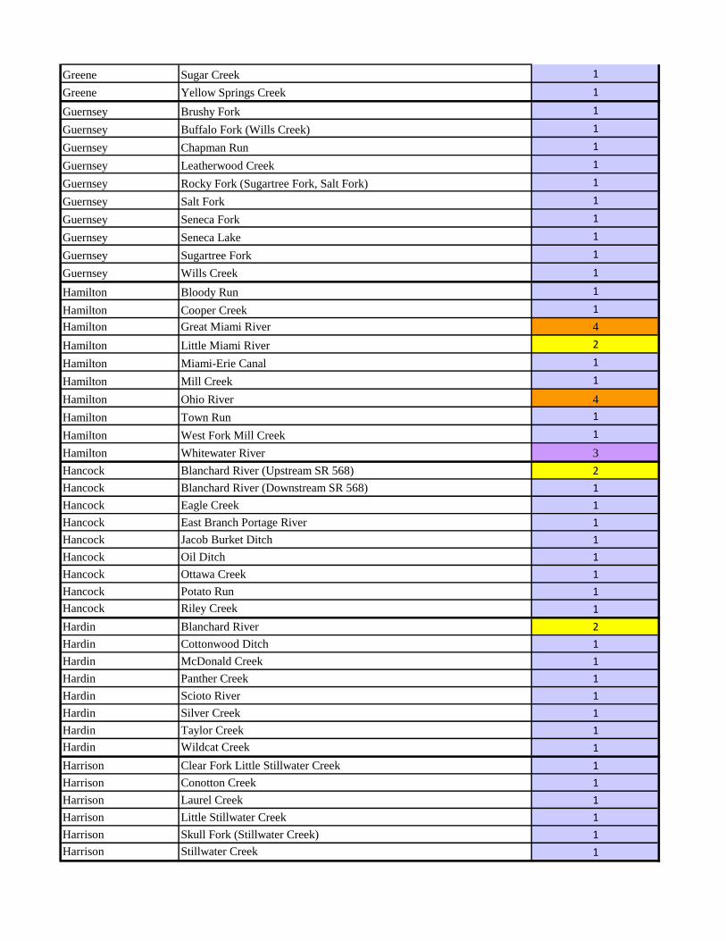
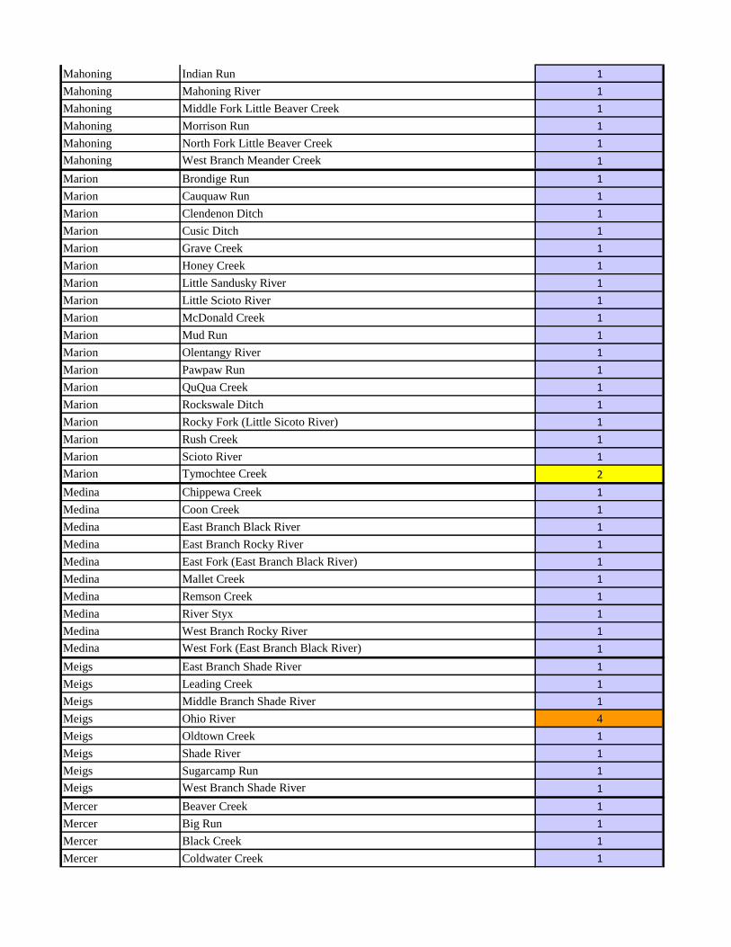
Appendix A: Ohio Mussel Stream List - 4/15/2016

Ashtabula Pymatuning Creek 2
Ashtabula Rock Creek 1
Ashtabula West Branch Ashtabula River 1
Athens East Branch Shade River 1
Athens Federal Creek 1
Athens Hocking River 1
Athens Long Run 1
Athens Margaret Creek 1
Athens McDougall Branch 1
Athens Middle Branch Shade River 1
Athens Mud Fork 1
Athens Ohio River 4
Athens Sharps Fork 1
Athens Strouds Run 1
Athens Sugar Creek 1
Athens Sunday Creek 1
Auglaize Auglaize River 1
Auglaize Clear Creek 1
Auglaize Koop Creek (aka Kopp Creek) 1
Auglaize Miami-Erie Canal 1
Auglaize St. Marys River 1
Auglaize Twomile Creek 1
Belmont Captina Creek 1
Belmont Stillwater Creek 1
Belmont Ohio River 3
Brown Cloverlick Creek 1
Brown Eagle Creek 1
Brown East Fork Little Miami River 2
Brown East Fork White Oak Creek 1
Brown Fivemile Creek 1
Brown Honey Run 1
Brown Indian Creek 1
Brown Ohio River 4
Brown Solomon Run 1
Brown Sterling Run 1
Brown West Fork Eagle Creek 1
Brown West Fork Ohio Brush Creek 1
Brown White Oak Creek 1
Butler Dicks Creek 1
Butler Fourmile Creek 1
Butler Great Miami River 4
Butler Millers Creek 1
Butler Sevenmile Creek 1
Carroll Conotton Creek 1

Carroll Indian Fork 1
Carroll Still Fork 1
Carroll Sandy Creek 1
Champaign Kings Creek 1
Champaign Little Darby Creek 1
Champaign Macochee Ditch 1
Champaign Mad River 1
Champaign Mosquito Creek 1
Champaign Pleasant Run 1
Champaign Proctor Run 1
Champaign Spain Creek 1
Champaign Treacle Creek 1
Clark Beaver Creek 1
Clark Buck Creek 1
Clark Little Miami River 2
Clark Mad River 1
Clark Medway Creek 1
Clark North Fork Deer Creek 1
Clark North Fork Little Miami River 1
Clermont Cloverlick Creek 1
Clermont East Fork Little Miami River 2
Clermont Indian Creek 1
Clermont Little Miami River 2
Clermont O'Bannon Creek 1
Clermont Ohio River 4
Clermont Poplar Creek 1
Clermont Stonelick Creek 1
Clermont Ten Mile Creek 1
Clinton Anderson Fork (Caesar Creek) 1
Clinton Caesar Creek 1
Clinton Cowan Creek 1
Clinton East Fork Little Miami River 1
Clinton Grassy Branch 1
Clinton Little East Fork 1
Clinton Todd Fork (Little Miami River) 1
Clinton West Branch Rattlesnake Creek 1
Clinton West Fork of East Fork (East Fork Little Miami River) 1
Columbiana Beaver Run 1
Columbiana Bull Creek 1
Columbiana Brush Creek 1
Columbiana Cold Run 1
Columbiana East Fork Stateline Creek 1
Columbiana Little Beaver Creek 1
Columbiana Little Bull Creek 1

Columbiana Mahoning River 1
Columbiana Middle Fork Little Beaver Creek 1
Columbiana North Fork Little Beaver Creek 1
Columbiana Ohio River 3
Columbiana Patterson Creek 1
Columbiana Sandy Creek 1
Columbiana West Fork Little Beaver Creek 1
Coshocton Killbuck Creek 2
Coshocton Kokosing River 1
Coshocton Little Wakatomika Creek 1
Coshocton Mohican River 1
Coshocton Muskingum River 4
Coshocton Trib. to Tuscarawas R. (RM 3.78) 1
Coshocton Tuscarawas River 3
Coshocton Walhonding River 2
Coshocton Wills Creek 1
Crawford Broken Sword Creek 1
Crawford Buckeye Creek 1
Crawford Little Scioto River 1
Crawford Mud Run 1
Crawford Olentangy River 1
Crawford Sandusky River 1
Crawford Shumaker Ditch 1
Cuyahoga Big Creek 1
Cuyahoga Chagrin River 1
Cuyahoga Chippewa Creek 1
Cuyahoga Cuyahoga River 3
Cuyahoga Doan Brook 1
Cuyahoga East Branch Rocky River 1
Cuyahoga Lake Erie 3
Cuyahoga Ohio and Erie Canal 1
Cuyahoga Rocky River 1
Cuyahoga Sagamore Creek 1
Cuyahoga Sulphur Spring Brook 1
Cuyahoga Tinkers Creek 1
Cuyahoga West Branch Rocky River 1
Darke Boyd Creek 1
Darke Dismal Creek 1
Darke Dividing Branch 1
Darke Grays Branch 1
Darke Greenville Creek 1
Darke Indian Creek 1
Darke Millers Fork 1
Darke Mississinewa River 1

Darke Mud Creek 1
Darke North Fork Stillwater River 1
Darke South Fork Stillwater River 1
Darke Stillwater River 2
Darke Swamp Creek 1
Defiance Auglaize River 1
Defiance Big Run 1
Defiance Gordon Creek 1
Defiance Lick Creek 1
Defiance Lost Creek 1
Defiance Maumee River 3
Defiance Miami-Erie Canal 1
Defiance Middle Fork Gordon Creek 1
Defiance Mud Creek 1
Defiance North Powell Creek 1
Defiance Powell Creek 1
Defiance South Fork Gordon Creek 1
Defiance St. Joseph River 2
Defiance Sulphur Creek 1
Defiance Tiffin River 1
Delaware Alum Creek 1
Delaware Bartholomew Run 1
Delaware Big Run 1
Delaware Big Walnut Creek 1
Delaware Blues Creek 1
Delaware Bokes Creek 1
Delaware Brondige Run 1
Delaware Culver Creek 1
Delaware Delaware Run 1
Delaware Duncan Run 1
Delaware Fulton Creek 1
Delaware Kebler Run 1
Delaware Long Run 1
Delaware Mill Creek 2
Delaware North Fork Rattlesnake Creek 1
Delaware Olentangy River 2
Delaware Ottawa Creek 1
Delaware Perfect Creek 1
Delaware Scioto River 1
Delaware Smith Run 1
Delaware South Fork Rattlesnake Creek 1
Delaware Sugar Creek 1
Delaware Turkey Run 1
Delaware West Branch Alum Creek 1
Delaware Whetstone Creek 1

Erie Chappel Creek 1
Erie Huron River 1
Erie Lake Erie 3
Erie Sugar Creek 1
Erie Old Woman Creek 1
Erie Plum Brook 1
Erie Rattlesnake Creek 1
Erie Sandusky Bay 3
Erie Sawmill Creek 1
Erie Vermilion River 1
Fairfield Arney Run 1
Fairfield Baldwin Run 1
Fairfield Blacklick Creek 1
Fairfield Clear Creek 1
Fairfield Dunkle Run 1
Fairfield Hocking River 1
Fairfield Hunters Run 1
Fairfield Little Rush Creek 1
Fairfield Pawpaw Creek 1
Fairfield Pleasant Run 1
Fairfield Rush Creek 1
Fairfield Sand Run 1
Fairfield South Fork Licking River 1
Fairfield Sycamore Creek 1
Fairfield Walnut Creek 1
Fayette Compton Creek 1
Fayette Crooked Creek 1
Fayette Deer Creek 1
Fayette East Fork Paint Creek 1
Fayette Lees Creek 1
Fayette Mills Branch 1
Fayette North Fork Paint Creek 1
Fayette Paint Creek 1
Fayette Rattlesnake Creek 1
Fayette Sugar Creek 1
Fayette Thompson Creek 1
Fayette West Branch Rattlesnake Creek 1
Fayette Wabash Creek 1
Franklin Alum Creek 1
Franklin Big Darby Creek 2
Franklin Big Run 1
Franklin Big Walnut Creek 1
Franklin Blacklick Creek 1
Franklin Clover Groff Ditch 1
Franklin Georges Creek 1

Franklin Grant Run 1
Franklin Hamilton Ditch 1
Franklin Hellbranch Run 1
Franklin Little Darby Creek 2
Franklin Ohio and Erie Canal 1
Franklin Olentangy River 1
Franklin Plum Run 1
Franklin Rocky Fork (Big Walnut Creek) 1
Franklin Scioto Big Run 1
Franklin Scioto River 4
Franklin Sugar Run 1
Franklin Walnut Creek 1
Fulton Bad Creek 1
Fulton Swan Creek 2
Fulton Tiffin River 1
Gallia Barren Creek 1
Gallia Black Fork (Symmes Creek) 1
Gallia Camp Creek 1
Gallia Chickamauga Creek 1
Gallia Dirtyface Creek 1
Gallia Little Chickamauga Creek 1
Gallia Ohio River 4
Gallia Raccoon Creek 1
Gallia Symmes Creek 1
Geauga Black Brook 1
Geauga Bridge Creek 1
Geauga Chagrin River 1
Geauga Cuyahoga River 1
Geauga East Branch Cuyahoga River 1
Geauga Grand River 1
Geauga Griswold Creek 1
Geauga South Branch Phelps Creek 1
Geauga Spring Brook 1
Geauga West Branch Cuyahoga River 1
Greene Anderson Fork (Caesar Creek) 1
Greene Caesar Creek 1
Greene Hebble Creek 1
Greene Little Miami River 2
Greene Mad River 1
Greene Massies Creek 1
Greene North Branch Caesar Creek 1
Greene North Fork Massies Creek 1
Greene South Branch Caesar Creek 1
Greene South Fork Massies Creek 1
Greene Sugar Creek 1
Greene Yellow Springs Creek 1
Guernsey Brushy Fork 1
Guernsey Buffalo Fork (Wills Creek) 1
Guernsey Chapman Run 1
Guernsey Leatherwood Creek 1
Guernsey Rocky Fork (Sugartree Fork, Salt Fork) 1
Guernsey Salt Fork 1
Guernsey Seneca Fork 1
Guernsey Seneca Lake 1
Guernsey Sugartree Fork 1
Guernsey Wills Creek 1
Hamilton Bloody Run 1
Hamilton Cooper Creek 1
Hamilton Great Miami River 4
Hamilton Little Miami River 2
Hamilton Miami-Erie Canal 1
Hamilton Mill Creek 1
Hamilton Ohio River 4
Hamilton Town Run 1
Hamilton West Fork Mill Creek 1
Hamilton Whitewater River 3
Hancock Blanchard River (Upstream SR 568) 2
Hancock Blanchard River (Downstream SR 568) 1
Hancock Eagle Creek 1
Hancock East Branch Portage River 1
Hancock Jacob Burket Ditch 1
Hancock Oil Ditch 1
Hancock Ottawa Creek 1
Hancock Potato Run 1
Hancock Riley Creek 1
Hardin Blanchard River 2
Hardin Cottonwood Ditch 1
Hardin McDonald Creek 1
Hardin Panther Creek 1
Hardin Scioto River 1
Hardin Silver Creek 1
Hardin Taylor Creek 1
Hardin Wildcat Creek 1
Harrison Clear Fork Little Stillwater Creek 1
Harrison Conotton Creek 1
Harrison Laurel Creek 1
Harrison Little Stillwater Creek 1
Harrison Skull Fork (Stillwater Creek) 1
Harrison Stillwater Creek 1

Henry Bad Creek 1
Henry Brubaker Creek 1
Henry Maumee River 3
Henry Miami-Erie Canal 1
Henry North Turkeyfoot Creek 1
Henry South Turkeyfoot Creek 1
Highland Baker Fork (Ohio Brush Creek) 1
Highland Clear Creek 1
Highland Dodson Creek 1
Highland East Fork Little Miami River 1
Highland East Fork White Oak Creek 1
Highland Middle Fork Lees Creek 1
Highland Lees Creek 1
Highland North Fork White Oak Creek 1
Highland Ohio Brush Creek 1
Highland Paint Creek 1
Highland Rattlesnake Creek 1
Highland Rock Lick 1
Highland Rocky Fork (Paint Creek) 1
Highland South Fork (Rocky Fork, Paint Creek) 1
Highland South Fork Lees Creek 1
Highland Turtle Creek 1
Hocking Clear Creek 1
Hocking Hocking River 1
Hocking Kitchen Run 1
Hocking Little Monday Creek 1
Hocking Monday Creek 1
Hocking Pine Creek 1
Hocking Rush Creek 1
Hocking Salt Creek 1
Hocking Sand Run 1
Hocking Scott Creek 1
Holmes Killbuck Creek 1
Holmes Lake Fork Mohican River 1
Holmes Mohican River 1
Huron Cole Creek 1
Huron East Branch Huron River 1
Huron East Branch Vermilion River 1
Huron Honey Creek 1
Huron Marsh Run 1
Huron Southwest Branch Vermilion River 1
Huron Vermilion River 1
Huron West Branch Huron River 1
Jackson Buckeye Creek 1
Jackson Little Salt Creek 1
Jackson Little Scioto River 1

Jackson Pigeon Creek 1
Jackson Sugarcamp Creek 1
Jackson Symmes Creek 1
Jefferson Cross Creek 1
Jefferson Brush Creek 1
Jefferson Ohio River 3
Jefferson Short Creek 1
Jefferson Yellow Creek 1
Knox East Branch of North Branch (Kokosing River) 1
Knox Indianfield Run 1
Knox Kokosing River 1
Knox Mohican River 1
Knox North Branch Kokosing River 1
Knox North Fork Licking River 1
Knox Otter Fork Licking River 1
Knox Sycamore Creek 1
Knox Vance Creek 1
Lake Chagrin River 3
Lake Chagrin River Estuary Channels 1
Lake Grand River 2
Lake Lake Erie 3
Lake Marsh Creek 1
Lake Mill Creek 1
Lawrence Buffalo Creek (Symmes Creek) 1
Lawrence Caulley Creek 1
Lawrence Indian Guyan Creek 1
Lawrence Johns Creek 1
Lawrence Ohio River 4
Lawrence Pine Creek 1
Lawrence Storms Creek 1
Lawrence Symmes Creek 1
Licking Beaver Run 1
Licking Dutch Fork Licking River 1
Licking East Fork Rattlesnake Creek 1
Licking Lake Fork Licking River 1
Licking Licking River 1
Licking Lobdell Creek 1
Licking North Fork Licking River 1
Licking Otter Fork Licking River 1
Licking Quarry Run 1
Licking Raccoon Creek 1
Licking Rocky Fork (Licking River) 1
Licking South Fork Licking River 1
Licking Wilkins Run 1
Logan Big Darby Creek 1
Logan Bokes Creek 1

Logan Flat Branch (Big Darby Creek) 1
Logan Great Miami River 2
Logan Hefflefinger Ditch 1
Logan Macochee Creek 1
Logan Mill Creek 1
Logan Muchinippi Creek 1
Logan Otter Creek 1
Logan Rush Creek 1
Logan Stony Creek 1
Lorain Charlemont Creek 1
Lorain East Branch Black River 1
Lorain East Branch Vermilion River 1
Lorain Lake Erie 3
Lorain Plum Creek 1
Lorain Vermilion River 3
Lorain Wellington Creek 1
Lorain West Branch Black River 1
Lorain West Branch Rocky River 1
Lucas Blystone Ditch 1
Lucas Cedar Creek 1
Lucas Driftmeyer Ditch 1
Lucas Duck Creek 1
Lucas Lake Erie 3
Lucas Maumee River 3
Lucas Miami-Erie Canal 1
Lucas Ottawa River 3
Lucas Otter Creek 1
Lucas Swan Creek (Upstream of RM 4.3) 2
Lucas Swan Creek (RM 4.3 to mouth) 1
Lucas Ten Mile Creek 1
Lucas Williams Ditch 1
Madison Barren Creek 1
Madison Big Darby Creek 2
Madison Bradford Creek 1
Madison Deer Creek 1
Madison Glade Run 1
Madison Little Darby Creek 2
Madison North Fork Deer Creek 1
Madison North Fork Paint Creek 1
Madison Oak Run 1
Madison Paint Creek 1
Madison Phifer Ditch 1
Madison South Fork Bradford Creek 1
Madison Spring Fork (Little Darby Creek) 1
Madison Sugar Run 1
Madison Walnut Run 1
Mahoning Indian Run 1
Mahoning Mahoning River 1
Mahoning Middle Fork Little Beaver Creek 1
Mahoning Morrison Run 1
Mahoning North Fork Little Beaver Creek 1
Mahoning West Branch Meander Creek 1
Marion Brondige Run 1
Marion Cauquaw Run 1
Marion Clendenon Ditch 1
Marion Cusic Ditch 1
Marion Grave Creek 1
Marion Honey Creek 1
Marion Little Sandusky River 1
Marion Little Scioto River 1
Marion McDonald Creek 1
Marion Mud Run 1
Marion Olentangy River 1
Marion Pawpaw Run 1
Marion QuQua Creek 1
Marion Rockswale Ditch 1
Marion Rocky Fork (Little Sicoto River) 1
Marion Rush Creek 1
Marion Scioto River 1
Marion Tymochtee Creek 2
Medina Chippewa Creek 1
Medina Coon Creek 1
Medina East Branch Black River 1
Medina East Branch Rocky River 1
Medina East Fork (East Branch Black River) 1
Medina Mallet Creek 1
Medina Remson Creek 1
Medina River Styx 1
Medina West Branch Rocky River 1
Medina West Fork (East Branch Black River) 1
Meigs East Branch Shade River 1
Meigs Leading Creek 1
Meigs Middle Branch Shade River 1
Meigs Ohio River 4
Meigs Oldtown Creek 1
Meigs Shade River 1
Meigs Sugarcamp Run 1
Meigs West Branch Shade River 1
Mercer Beaver Creek 1
Mercer Big Run 1
Mercer Black Creek 1
Mercer Coldwater Creek 1

Mercer St. Mary's River 1
Mercer Twelvemile Creek 1
Mercer Wabash River 1
Miami Great Miami River 2
Miami Greenville Creek 1
Miami Honey Creek 1
Miami Little Painter Creek 1
Miami Lost Creek 1
Miami Miami-Erie Canal 1
Miami Mill Creek 1
Miami Spring Creek 1
Miami Stillwater River 2
Miami Trotters Creek 1
Monroe Clear Fork (Little Muskingum River) 1
Monroe Cranenest Fork (Little Muskingum River) 1
Monroe Little Muskingum River 1
Monroe Ohio River 3
Monroe Sunfish Creek 1
Monroe Witten Fork 1
Montgomery Drylick Run 1
Montgomery Great Miami River 3
Montgomery Holes Creek 1
Montgomery Mad River 1
Montgomery Stillwater River 2
Montgomery Toms Run 1
Montgomery Twin Creek 1
Montgomery Wolf Creek 1
Morgan Dyes Fork (Meigs Creek) 1
Morgan East Branch Sunday Creek 1
Morgan Little Wolf Creek 1
Morgan Mans Fork 1
Morgan Meigs Creek 1
Morgan Muskingum River 4
Morgan Olive Green Creek 1
Morgan West Branch Wolf Creek 1
Morrow Alum Creek 1
Morrow Big Walnut Creek 1
Morrow Bunker Run 1
Morrow Flat Run 1
Morrow Kokosing River 1
Morrow Mill Creek 1
Morrow Shaw Creek 1
Morrow West Branch Alum Creek 1
Morrow Whetstone Creek 1
Muskingum Bartlett Run 1
Muskingum Licking River 1

Muskingum Meigs Creek 1
Muskingum Miller Creek 1
Muskingum Muskingum River 4
Muskingum Salt Creek 1
Muskingum Wakatomika Creek 1
Muskingum White Eyes Creek 1
Noble Barnes Run 1
Noble Beaver Creek 1
Noble Buffalo Creek 1
Noble East Fork Duck Creek 1
Noble Olive Green Creek 1
Noble Rannells Creek 1
Noble Seneca Fork 1
Noble Seneca Lake 1
Noble South Fork (Seneca Fork) 1
Noble West Fork Duck Creek 1
Noble Wolf Run 1
Ottawa Lake Erie 3
Ottawa Crane Creek 1
Ottawa Magee Marsh 1
Ottawa Portage River 3
Ottawa Sandusky Bay 1
Ottawa Sugar Creek 1
Ottawa Toussaint Creek 1
Ottawa Toussaint River 1
Ottawa Turtle Creek 1
Paulding Auglaize River 1
Paulding Blue Creek 1
Paulding Flatrock Creek 1
Paulding Gordon Creek 1
Paulding Hoaglin Creek 1
Paulding Little Auglaize River 1
Paulding Marie Delarme Creek 1
Paulding Maumee River 3
Paulding Middle Creek 1
Paulding North Creek 1
Paulding Prairie Creek 1
Paulding South Creek 1
Paulding Zielke Ditch 1
Paulding Zuber Cutoff 1
Perry Center Branch Rush Creek 1
Perry Coal Brook 1
Perry Dotson Creek 1
Perry Jonathan Creek 1
Perry Little Rush Creek 1
Perry Sunday Creek 1

Pickaway Big Darby Creek 2
Pickaway Big Walnut Creek 1
Pickaway Deer Creek 1
Pickaway Dry Run 1
Pickaway Greenbrier Creek 1
Pickaway Hargus Creek 1
Pickaway Lick Run 1
Pickaway Ohio and Erie Canal 1
Pickaway Opossum Run 1
Pickaway Peters Run 1
Pickaway Salt Creek 1
Pickaway Scioto River 4
Pickaway Scippo Creek 1
Pickaway Slate Run 1
Pickaway Turkey Run 1
Pickaway Walnut Creek 1
Pickaway Yellowbud Creek 1
Pike Beaver Creek 1
Pike Morgan Fork (Sunfish Creek) 1
Pike Ohio and Erie Canal 1
Pike Scioto River 4
Pike Sunfish Creek 1
Portage Aurora Branch (Chagrin River) 1
Portage Breakneck Creek 1
Portage Cuyahoga River 1
Portage Eagle Creek 1
Portage Hinckley Creek 1
Portage Mahoning River 1
Portage Plum Creek 1
Portage Sand Creek 1
Portage Tinkers Creek 1
Portage Trib. to Cuyahoga R. (RM 63.82) 1
Preble Millers Fork 1
Preble Sevenmile Creek 1
Preble Twin Creek 1
Putnam Auglaize River 1
Putnam Blanchard River 1
Putnam Jennings Creek 1
Putnam Little Auglaize River 1
Putnam North Powell Creek 1
Putnam Ottawa River 1
Putnam Plum Creek 1
Putnam Riley Creek 1
Richland Black Fork Mohican River 1
Richland Cedar Fork (Clear Fork Mohican River) 1
Richland Clear Fork Mohican River 1

Richland Rocky Fork Mohican River 1
Ross Buckskin Creek 1
Ross Compton Creek 1
Ross Deer Creek 1
Ross Little Salt Creek 1
Ross Middle Fork Salt Creek 1
Ross North Fork Paint Creek 1
Ross Paint Creek 1
Ross Poe Run 1
Ross Salt Creek 2
Ross Scioto River 4
Ross Walnut Creek 1
Ross Yellowbud Creek 1
Sandusky Green Creek 1
Sandusky Gries Ditch 1
Sandusky Lake Erie 3
Sandusky Little Muddy Creek 1
Sandusky Muddy Creek 1
Sandusky Muskellunge Creek 1
Sandusky Portage River 1
Sandusky Raccoon Creek 1
Sandusky Sandusky Bay 1
Sandusky Sandusky River 1
Sandusky Sugar Creek 1
Sandusky Wolf Creek 1
Scioto Hales Creek 1
Scioto Little Scioto River 1
Scioto Ohio River 4
Scioto Pine Creek 1
Scioto Rocky Fork Little Scioto River 1
Scioto Scioto Brush Creek 2
Scioto Scioto River 4
Scioto South Fork Scioto Brush Creek 2
Scioto Turkey Creek 1
Seneca Beaver Creek 1
Seneca Honey Creek 1
Seneca Morrison Creek 1
Seneca Sandusky River 1
Seneca Sugar Creek 1
Seneca Wolf Creek 1
Shelby Great Miami River 2
Shelby Loramie Creek 1
Shelby Nine Mile Creek 1
Shelby Tawawa Creek 1
Shelby Turtle Creek 1
Stark Deer Creek 1

Stark East Branch Nimishillen Creek 1
Stark Mahoning River 1
Stark Middle Branch Nimishillen Creek 1
Stark Nimishillen Creek 1
Stark Sandy Creek 1
Stark Swartz Ditch 1
Stark Tuscarawas River 1
Stark West Sippo Creek 1
Summit Brandywine Creek 1
Summit Cuyahoga River 1
Summit Furnace Run 1
Summit Haskell Run 1
Summit Metzgers Ditch 1
Summit Ohio and Erie Canal 1
Summit Tuscarawas River 1
Summit Yellow Creek 1
Trumbull Baughman Creek 1
Trumbull Eagle Creek 1
Trumbull Grand River 1
Trumbull Little Yankee Creek 1
Trumbull Mahoning River 1
Trumbull Pymatuning Creek 2
Trumbull West Branch Mahoning River 1
Tuscarawas Buckhorn Creek 1
Tuscarawas Dunlap Creek 1
Tuscarawas Goettge Run 1
Tuscarawas Little Stillwater Creek 1
Tuscarawas Ohio and Erie Canal 1
Tuscarawas Sandy Creek 1
Tuscarawas Stillwater Creek 1
Tuscarawas Sugar Creek 1
Tuscarawas Tuscarawas River 1
Union Big Darby Creek 2
Union Blues Creek 1
Union Bokes Creek 1
Union Buck Run 1
Union Flat Branch (Big Darby Creek) 1
Union Fulton Creek 1
Union Little Darby Creek 2
Union Mill Creek 2
Union North Branch Crosses Run 1
Union Powderlick Run 1
Union Robinsons Run 1
Union Rush Creek 1
Union Spain Creek 1
Union Sugar Run 1

Union Treacle Creek 2
Van Wert Jennings Creek 1
Van Wert Little Auglaize River 1
Van Wert St. Marys River 1
Van Wert Town Creek 1
Vinton Little Raccoon Creek 1
Vinton Middle Fork Salt Creek 1
Vinton Pigeon Creek 1
Vinton Raccoon Creek 1
Vinton Salt Creek 1
Warren Caesar Creek 1
Warren Clear Creek 1
Warren Flat Fork (Caesar Creek) 1
Warren Great Miami River 2
Warren Little Miami River 2
Warren Millers Creek 1
Warren North Branch Dicks Creek 1
Warren Simpson Creek 1
Warren Todd Fork (Little Miami River) 1
Warren Turtle Creek 1
Warren Twin Creek 1
Washington Archers Fork 1
Washington Danas Run 1
Washington Davis Creek 1
Washington Duck Creek 1
Washington East Branch Little Hocking River 1
Washington East Fork Duck Creek 1
Washington Little Hocking River 1
Washington Little Muskingum River 1
Washington Muskingum River 4
Washington Ohio River 4
Washington Olive Green Creek 1
Washington West Branch Little Hocking River 1
Washington West Branch Wolf Creek 1
Washington West Fork Duck Creek 1
Washington Whipple Run 1
Washington Wolf Creek 1
Wayne Chippewa Creek 1
Wayne Killbuck Creek 1
Wayne Little Killbuck Creek 1
Wayne Muddy Fork Mohican River 1
Wayne Shreve Creek 1
Wayne Steele Ditch 1
Wayne Sugar Creek 1
Williams Bear Creek 1
Williams Beaver Creek 1

Williams Brush Creek 1
Williams Clear Fork St. Joseph River 1
Williams Eagle Creek 1
Williams East Branch St. Joseph River 1
Williams Fish Creek 2
Williams Mill Creek 1
Williams Mill Stream Drain 1
Williams Nettle Creek 1
Williams Prairie Creek 1
Williams Silver Creek 1
Williams St. Joseph River 2
Williams Tiffin River 1
Williams West Branch St. Joseph River 2
Wood Beaver Creek 1
Wood Dry Creek 1
Wood Maumee River 3
Wood Miami-Erie Canal 1
Wood Middle Branch Portage River 1
Wood Needles Creek 1
Wood North Branch Portage River 1
Wood Portage River 1
Wood Rader Creek 1
Wood Rocky Ford 1
Wood South Branch Portage River 1
Wood Tontogany Creek 1
Wyandot Broken Sword Creek 1
Wyandot Little Sandusky River 1
Wyandot Little Tymochtee Creek 1
Wyandot Negro Run 1
Wyandot Potato Run 1
Wyandot Sandusky River 1
Wyandot Sycamore Creek 1
Wyandot Tymochtee Creek 2
Wyandot Warpole Creek 1

Ohio Mussel Habitat Assessment Form
Project Information
Methods
Habitat Description of Survey Area
Project Name:
County: Township:
Latitude (DD.DDDD): Longitude (DD.DDDD):
Stream Name: Group # (From Appendix A):
Name of Surveyor(s):
Qualification of Surveyor(s): ☐ USFWS Approved ☐ ODNR Approved ☐ Aquatic Biologist (minimum)
Date of Survey: Distance Surveyed (ft.):
Total Survey Time (min. x people): Scientific Collector’s Permit Number(s):
Note any deviations from the Ohio Mussel Habitat Assessment Methods :
Drainage Area at Survey Location (mi2): Water Temp. (
oF): Air Temp. (
oF):
Substrate Types (include %):
☐ Boulder ☐ Gravel ☐ Bedrock ☐ Detritus ☐ Silt
☐Cobble ☐ Sand ☐ Hardpan ☐ Muck ☐ Artificial
Water Level: ☐ High ☐ Up ☐ Normal ☐ Low ☐Dry/Interstitial
Visibility: ☐ 0-15 cm ☐ 15-30 cm ☐ 30-50 cm ☐ >50 cm ☐ Visible to Bottom
Average Depth (cm): Riffle Run Pool
Max Depth (cm): Riffle Run Pool

Results
Evidence of Mussels: Presence of fresh dead mussel shells and living mussels will trigger a full mussel survey
☐ None
☐ Mussel Shell Only - Subfossil
☐ Mussel Shell Only - Weathered Dead
☐ Mussel Shell Only - Fresh Dead
☐ Living Mussels
Site Sketch. Approximate numbers and locations of shells and live mussels. Include species list if possible.
Required Attachments 1) Location Map and 2) Photo Log

Appendix B: Reconnaissance Survey for Unionid Mussels
Objective: To determine the presence or absence of unionid mussels within a project area that will require in-stream work on a Group 1 stream or on streams which the watershed area above the impact point is 2590 ha (10 mi2) or larger that contain suitable mussel habitat that are not listed as a mussel stream by USFWS and ODNR.
Limitations: This protocol is to be used on small wade-able streams that are not known to contain federally listed species, including streams on the Group 1 list in the Ohio Mussel Survey Protocol (ODNR 2015) or unlisted streams over 10 square miles with suitable mussel habitat. Survey work must be conducted during the warm months from May 1 to October 1, unless prior approval is granted. Water levels at the site must be normal or below normal, and water clarity must be good. All stream substrates within the survey reach must be visible and able to be surveyed. Streams that are very deep, consistently turbid, or with other issues that preclude searching the stream bottom throughout the survey reach cannot be surveyed using this protocol and a State and/or Federally permitted malacologist should survey the site using the Group 1 stream timed search protocol as outlined in the Ohio Mussel Survey Protocol.
The biologists conducting the surveys must have the qualifications stated in Appendix D and should possess a state scientific collector’s permit.
Survey Area: The entire area under the existing structure, the area where the proposed structure will be placed (if different), and a buffer area beginning 400 feet downstream of the downstream edge of the existing or proposed structure to 200 feet upstream of the upstream edge of the existing or proposed structure (whichever is the larger survey area) should be surveyed. If the biologist feels that additional buffer is necessary to adequately assess the area for mussels, then the additional area should be searched. If weathered dead shells are observed but no live mussels are found during the upstream and downstream search, an additional 20 minutes should be dedicated to a search of the salvage zone.
A larger buffer area for these surveys is necessary as the surveyor is using only visual methods to determine if mussels are present, and some mussels in an area may not be visible above the stream-bed surface. The longer search area increases the likelihood that mussels will be observed if present in the area.
Methods: Beginning at the downstream end of the buffer zone, the stream substrates, stream banks, and gravel bars should be visually searched for evidence of shells, shell fragments, or live mussels. All stream habitats (not just suitable habitats) must be visually inspected, but special attention should be paid to heterogeneous substrates where living mussels may be difficult to see (e.g. sand and gravel interspersed with cobbles). Mussel viewing tubes or glass-bottom buckets may be used during the survey to aid in viewing the substrates. Live mussels should not be removed from the substrate for identification unless the surveyor is qualified to survey 1 – 4 systems as specified in Appendix D. The site should be searched for at least 60 minutes for smaller streams (10-100) square miles, or 90 minutes for larger streams (above 100 square miles), unless evidence of a mussel population is found. Once the presence of live mussels or fresh dead shells is confirmed, the survey does not have to continue. If only weathered dead shells or shell fragments are observed, the entire survey time (either 60 or 90 minutes based on stream size) should be used and an additional 20 minutes should be dedicated to a search of the salvage zone to determine if mussels are still present within the survey area. No species list will be generated from these surveys, unless the surveyor is qualified to survey 1 – 4 systems as specified in

Appendix D. Representative photos of the survey area, and shell material observed and live mussels (in-situ) should be taken.
Reporting: In the Ohio Mussel Habitat Assessment Form, the surveyor will fill out the top portion of the Unionid Mussel table. Representative photos of the stream, stream habitats/substrates, and shells/live mussels will be included in the project photo log. The Additional Information box will include the following information:
1. Total length of survey area (including area directly under the existing and proposed structures, if different and buffers)
2. A brief description of the search methods used at the site. 3. A habitat description including substrate types, average water depths, stream development
(riffle/run/pool), and any obvious pollution or stream stability issues. 4. Approximate numbers and location(s) of shells and live mussels (include species list if biologist
has identification expertise). Additional Survey Requirements: The presence of fresh dead mussel shells and live mussels will trigger a mussel survey by a qualified surveyor as described in the Ohio Mussel Survey Protocol.

Appendix C: Contact information for State and Federal agencies
State Of Ohio Contact
John Navarro Ohio Department of Natural Resources Division of Wildlife 2045 Morse Road, G-3 Columbus, Ohio 43229-6693 (614) 265-6346 [email protected]
U.S. Fish and Wildlife Service Contact
Angela Boyer U.S. Fish and Wildlife Service Ecological Services 4625 Morse Road, Suite 104 Columbus, Ohio 43230 (614) 416-8993, ext.22 [email protected]
The Ohio State University Contact
G. Thomas Watters, PhD The Ohio State University Museum of Biological Diversity 1315 Kinnear Road Columbus, OH 43212 USA 614-292-6170 [email protected]

Appendix D: Minimum Qualifications for Mussel Reconnaissance and Surveys
To work with mussels in Ohio there are three levels of minimum qualifications required based on location and survey type. Satisfaction of a higher qualification level allows the surveyor to work at the lower levels. Work at all three levels require an Ohio Scientific Collectors Permit from the Division of Wildlife. The three levels of qualification are as follows: 1) Survey of Group 2 and 4 Systems: The minimum qualifications to survey Group 2 and 4
streams, which are likely to have federally listed mussels present, is a federal permit from the USFWS. For information on the requirements for a federal permit, reference the USFWS contact in Appendix C.
2) Survey of Group 1 and 3 Systems: The minimum qualifications to survey Group 1 and 3
systems, which are not likely to have federally listed mussels present, are based upon knowledge of and experience in the performance of mussel surveys.
Survey Experience: Surveyors must have at least two (2) years of field experience in a position including direct responsibility for and participation in conducting mussel surveys. Proficient in Identification: Surveyors must have passed the Standardized Freshwater Mussel Identification Test (Appendix E). Education: Surveyors must have a Bachelor of Science degree in biology, environmental science, natural resources or related field with at least three 3-hour courses from or related to those in the following list: Aquatic ecology, Fisheries, Hydrology, Aquatic Entomology, Limnology, Ichthyology, and Plant Taxonomy. Qualifying Experience: In lieu of the educational experience listed above, surveyors must have a minimum of four years of experience in a position including direct responsibility for and participation in conducting surveys for and documenting aquatic fauna and flora is required.
3) Reconnaissance of Group 1 Systems: Reconnaissance surveys are used to determine if a full
mussel survey is required. For reconnaissance of Group 1 streams (or on streams which the watershed is >10 mi2) to determine if mussels are present, the surveyor must satisfy the educational or qualifying experience listed above.
Submittal Requirements for category 2 and 3 listed above:
Resumes and, if applicable, curricula vitae.
A list of each individual's academic coursework related to aquatic ecology or evidence of qualifying experience surveying for and documenting aquatic fauna and flora.
Please send your qualifications to the Division of Wildlife contact in Appendix C.

Appendix E: Standardized Freshwater Mussel Identification Test Anyone wanting to conduct mussel surveys in Ohio will need to have passed the mussel identification test or have a valid Federal permit. Passing the Ohio test allows you to survey Group 1 and 3 systems, while having a Federal permit allows you to survey all four groups. Anyone with a valid Federal permit is welcome, but will not be required, to take the mussel identification test. Tests are administered by appointment only and at the discretion of the OSU Division of Molluscs. All efforts will be made to accommodate testing dates. Please call (614) 292-6170 to make your appointment. Three tests are available, so please specify which test you wish to take when making your appointment. The list of taxa on the test is available by request at [email protected] or [email protected]. Records of who passed the test will be maintained by the ODNR Division of Wildlife. Specific test information:
1. Three test are available: State-wide (60 species), Ohio River drainage (56 species), Lake Erie drainages (40 species).
2. The test will be given between 8 AM and 4 PM, Monday through Friday by appointment only.
3. The test will be given at the Museum of Biological Diversity (The Ohio State University, 1315 Kinnear Rd., Columbus, OH 43212).
4. Daily parking passes are available for participants for $6 (cash only). 5. The test is “open book” so you may bring any outside sources to the test. 6. The test must be completed in three (3) hours. 7. Only one person may take the test at a time. 8. You may return to any previous specimens as needed. 9. Feel free to ask questions. 10. You may retake the test as many times as necessary, but the entire test must be retaken
each time. You must allow at least one (1) day in between attempts. 11. Passing grade:
100% of federal T & E species
80% of Ohio T & E species
80% of entire test.

APPENDIX F: Report Checklist
INTRODUCTION:
Description of the stream and watershed including:
Name (if stream is named)
Receiving waters of surveyed stream
Location , including:
Coordinates – at center of ADI
River mile (if available)
Township (if applicable)
County
Drainage area at survey site
Summary of any water quality data or previous mussel survey reports near the area of impact (OEPA
Aquatic Life Use designation)
Surrounding land use
METHODS:
Personnel
Date(s) of survey
Area surveyed, including:
Description of survey/buffer areas (e.g., length, bank-to-bank)
Coordinates of survey/buffer areas (ADI, US, DS)
Map delineating survey/buffer areas (ADI, US, DS, LT). Map can be included within text or in Figures &
Tables section.
Survey method, including:
Type of mussel survey completed (e.g. Phase I, Phase II, Timed Visual Search)
Length and spacing of transects or size of the cells
Time searched
Method of detection (e.g. SCUBA, view bucket, quadrats)
Whether or not banks were searched for shells
Trigger – for Phase II studies
Description of additional transects (for Phase II studies), including coordinates and delineated map
Mussel handling and processing procedures
Quality Control Procedures (Includes taking representative photos of each species and video of any
questionable specimens)
RESULTS:
Habitat Assessment within each transect, cell, or timed search area, including:
Substrate composition (include information about the stability of the substrates)
In-stream features (e.g. channel alterations, impoundments)
Average stream depth
Visibility (say what the visibility was, not just that it met the minimum requirements)
Water temperature
Suitable habitats within the area of the survey
Photos of stream and substrate

An overview of the results, including:
Number of individuals found
Number of species found
Any notable species found
A description of the results from Phase I and Phase II separately
Tables of results, including (either within text or attached in Appendix):
Species data for each transect and/or cell
Relative abundance
Condition (living/fresh dead/weathered/subfossil)
Sex of individuals if determinable
Morphometric data (optional if not required by permit or site-specific authorization)
MUSSEL RELOCATION (This is required for all relocations; however, additional information may be required for
Group 2 and 4 systems where federal species may be encountered. For these situations, follow all requirements in
the project specific Biological Opinion):
Relocation site, including:
Location (coordinates at center)
Map delineating area. Map can be included within text or in Figures & Tables section.
Results of required 15-minute qualitative survey (provide coordinates in decimal degrees)
Method of salvaging mussels from survey area
CONCLUSION:
Summary of findings, and conclusions
REFERENCES:
Include citations for any literature cited within the text of the report (e.g. Smith et al., for excavation
methods)
FIGURES & TABLES:
If not provided in text, provide a separate section for Figures (including maps and aerial photos showing
extent of survey) and Tables (transect and quadrat data, morphometric data)
APPENDICES:
Photos of stream and substrates
Representative photos of each mussel species found
Video of questionable species
Raw Data Sheets
Copy of State and/or Federal permits
Site-specific authorization from USFWS For Group 2 and Group 4 stream surveys

Appendix G. Summary of survey area buffer distances, salvage area
buffer distances, and maximum transect spacing
(Survey extent shall include the area of direct impact (ADI) and all applicable buffers. After
demonstrating need and receiving approval, mussels may be relocated from Salvage Area. Salvage Area
includes the ADI and all applicable buffers. Units are in meters.)
Survey Area Buffers (in addition to ADI)
Salvage Area Buffers (in addition to ADI)
Maximum Transect Spacing
US DS LT US & LT DS
Group 4 Potential Phase 2 Surveys Required
Dredging 150 500 150 10 10 50c
Linear Projects
Maintenance at Existing Facility
25 25 25 5 10 50a,c
New Facility or Expansion Downstream
150 500 150 5 10 50a,c
Expansion Upstream
150 150 150 5 10 50a,c
Other Projects (Hydropower, dam removal, etc.)
Project Specific 100c
Bridge Projects 50 100 BB 5 10 10
Waterline/Pipeline Corridor Disturbances
50 100 BB 5 10 10
Shoreline Protection 10 10 10 5 10 50
Bridge Projects 50 100 BB 5 10 10
Projecting Dike Structures (i.e., not parallel to shore)
10 20 10 5 10 TS
Outfalls 10 MZ + 100 10 PS PSc
Non-Commercial Docks No Survey Required (see criteria on p. 9)
Group 3
Relocation at time of survey if approved
Dredging (Sand and Gravel) 150 500 150 10 50c
Dredging (Maintenance) 50 150 50 10 50c
Linear Projects 25 25 25 5 10 50a
Other Projects (Hydropower, dam removal, etc.)
Project Specific 100
Bridge Projects 10 25 BB 5 10 TS

Waterline/Pipeline Corridor Disturbances
10 25 BB 5 10 TS
Shoreline Protection 10 10 10 5 10 TS
Projecting Dike Structures (i.e., not parallel to shore)
10 20 10 5 10 TS
Outfalls 10 MZ + 20 10 PS
Non-Commercial Docks No Survey Required (see criteria on p. 9)
Group 2 Potential Phase 2 Surveys Required
Other Projects (Hydropower, dam removal, etc.)
Project Specific 10
Bridge Projects 50 100 BB 5b 10 10
Waterline/Pipeline Corridor Disturbances
50 100 BB 5 10 10
Shoreline Protection 10 10 10 5 10 10
Outfalls 10 MZ + 20 10 PS 10
Group 1 Relocation at time of survey if approved
Other Projects (Hydropower, dam removal, etc.)
Project Specific TS or 10
Bridge Projects 10 25 BB 5b 10 TS
Waterline/Pipeline Corridor Disturbances
10 25 BB 5 TS
Shoreline Protection 10 10 10 5 10 10
a - transects should be placed to bisect instream structures b - 10 m buffer to clear around culverted causeways c - A minimum of 500 m of transects shall be surveyed TS - Qualitative Timed Search Surveys permitted PS - Project Specific BB - Bank to Bank MZ - Mixing Zone US - Upstream LT - Lateral DS - Downstream

1
Appendix H. Species marked with an “X” should be excluded when defining a diverse mussel bed that may include FLS.
(These species are not used because of their general habitat preference and their common occurrence in silt and sand, and because they are not typically associated with the current list of FLS in Ohio.)
Species Stream Group 2 Stream Group 4
Anodonta suborbiculata X
Anodontoides ferussacianus X X
Lampsilis radiata luteola (=siliquoidea) X X
Lasmigona complanata X X
Leptodea fragilis X
Potamilus ohiensis X
Potamilus alatus X
Pyganodon grandis X X
Strophitus undulatus X X
Utterbackia imbecillis X X

presence with a pre-determined probability (with excavation)Uses a simple formulae to determine area that needs to be searched to detect species presence with a pre-determined probability.The formulae is Prob(species detection) = 1-exp(-a*b*m), where b is search efficiency or detectability and m is species density.
Input density, search efficiency, and search area or prob of spp detection
Density or
no. per m2
(m)
Search
efficiency
(b)
Search
area (m2)
Prob of
species
detection
Density or
no. per m2
(m)
Search
efficiency
(b)
Search
area (m2)
Prob of
species
detection0.01 0.1 450 0.362372 0.01 0.4 301 0.70.01 0.6 450 0.932794 0.01 0.8 288 0.9
"=1-EXP(-A10*B10*C10)" "=-LN(1-J10)/(G10*H10)"
Input study area and abundance instead of density
Study Area
(sq m) Abundance
Search
efficiency
(b)
Search
area (m2)
Prob of
species
detection
Study Area
(sq m) Abundance
Search
efficiency
(b)
Search
area (m2)
Prob of
species
detection4500 45 0.4 495 0.861931 4500 45 0.4 301 0.74500 45 0.6 450 0.932794 4500 45 0.4 576 0.9
"=1-EXP(-(B18/A18)*C18*D18)" "=-LN(1-K18)/((H18/G18)*I18)"
Appendix I: Formulae to determine area that needs to be searched to detect species
Solve for Prob of spp detection Solve for Search area (sq m)
Solve for Prob of spp detection Solve for Search area (sq m)

Appendix J: Identification of Mussel Shell Weathering
Objective: It is important to recognize that the weathering process is a continuum and cannot always be assigned to one of the three categories below. Weathering depends on where the shell has been since the animal died. Shells exposed to the sun and elements may weather much faster than a shell buried in a river bank. Shells in collections may be in great condition for hundreds of years. For this reason it is difficult to say with any certainty how long a shell has been dead.
Fresh Dead Periostracum (outer layer) of shells not faded or peeling. Inner layer still with mother-of-pearl sheen, not flaking or infused with green algae.
Weathered dead Periostracum faded or discolored, often peeling and brittle. Inner layer no longer lustrous, often dull silver or faded, may be infused with green algae.
Subfossil Shell chalky, brittle. Periostracum usually absent. Inner layer faded, may be flaking off in layers.