OFR 2004-7, A Self-Guided Tour of the Geology of the...
13
A Self-Guided Tour of the Geology of the Columbia River Gorge— Portland Airport to Skamania Lodge, Stevenson, Washington by David K. Norman and Jaretta M. Roloff WASHINGTON DIVISION OF GEOLOGY AND EARTH RESOURCES Open File Report 2004-7 March 2004 N A T U R A L R E S O U R C E S trip location
-
Upload
truongkiet -
Category
Documents
-
view
216 -
download
2
Transcript of OFR 2004-7, A Self-Guided Tour of the Geology of the...

A Self-Guided Tour of theGeology of the
Columbia River Gorge—Portland Airport to
Skamania Lodge,Stevenson, Washington
by David K. Norman andJaretta M. Roloff
WASHINGTONDIVISION OF GEOLOGY
AND EARTH RESOURCES
Open File Report 2004-7March 2004
NA
TU
RA
LR
ES
OU
RC
ES
triplocation

DISCLAIMER
Neither the State of Washington, nor any agency thereof, nor any of their em-ployees, makes any warranty, express or implied, or assumes any legal liabilityor responsibility for the accuracy, completeness, or usefulness of any informa-tion, apparatus, product, or process disclosed, or represents that its use wouldnot infringe privately owned rights. Reference herein to any specific commercialproduct, process, or service by trade name, trademark, manufacturer, or other-wise, does not necessarily constitute or imply its endorsement, recommendation,or favoring by the State of Washington or any agency thereof. The views andopinions of authors expressed herein do not necessarily state or reflect those ofthe State of Washington or any agency thereof.
WASHINGTON DEPARTMENT OF NATURAL RESOURCES
Doug Sutherland—Commissioner of Public Lands
DIVISION OF GEOLOGY AND EARTH RESOURCES
Ron Teissere—State GeologistDavid K. Norman—Assistant State Geologist
Washington Department of Natural ResourcesDivision of Geology and Earth ResourcesPO Box 47007Olympia, WA 98504-7007Phone: 360-902-1450Fax: 360-902-1785E-mail: [email protected]: http://www.dnr.wa.gov/geology/
Cover photo: Looking east up the Columbia River Gorge from the Women’sForum Overlook. Crown Point and its Vista House are visible on top of the cliffon the right side of the river. I-84 runs below. Cape Horn is the sheer section ofcliffs slightly upriver and across from Crown Point.
Published in the United States of America

A Self-Guided Tour of theGeology of the
Columbia River Gorge—Portland Airport to
Skamania Lodge,Stevenson, Washington
by David K. Norman andJaretta M. Roloff
WASHINGTONDIVISION OF GEOLOGY
AND EARTH RESOURCES
Open File Report 2004-7March 2004
Po
rtla
nd
Inte
rna
tio
na
lA
irp
ort
(V1)
(V3)
Sto
p1
Sto
p2
Mo
un
tH
oo
d
River
Be
aco
nR
ock
Casc
ad
eL
ock
s
Sand
y
River
Gre
sha
m
La
ke
Osw
ego
Wa
sho
ug
alWash
ougal
No
rth
Bon
nev
ille
Sk
am
an
ia
Eagle
CreekBridge
ofth
eG
ods
(toll
$1.0
0)
Bul
l
Run
Riv
er
Bull
Run
Res
ervo
ir
Pe
pp
er
Mo
un
tain
La
rch
Mo
un
tain
Cro
wn
Po
int
Bo
nn
evill
eD
am
Ste
ven
son
Will
amet
te
River
Port
lan
d
Va
nco
uv
er14
20
5
84
30
GO
RG
E
SC
EN
ICA
RE
A
500
50
3
30
26
5
Ca
ma
sC
ap
eH
orn
NA
T’L
Ta
ble
Mo
un
tain
Tro
utd
ale
Col
umbi
a
Riv
er
Mo
un
tZ
ion
Mu
ltn
om
ah
Fa
lls(V
2)
(Sk
am
an
iaL
od
ge)
(V4)
Mo
un
tA
da
ms
Mo
un
tS
t.H
ele
ns
ex
it2
2
Do
dso
n
Co
rbet
t
Bo
rin
g
Mo
un
tTa
bo
rK
elly
Butte
Ro
cky
Butte
ex
it2
5e
xit
18
ex
it3
1
CO
LU
MB
IAR
IVE
Re
xit
35
ex
it4
1
ex
it4
4
12
2°
45
°30
�
Fig
ure
1.
Lo
ca
tio
nm
ap
.
ii

A Self-Guided Tour of the Geology of theColumbia River Gorge—Portland Airportto Skamania Lodge, Stevenson, Washington
Prepared for the Association of American State Geologists96th Annual Meeting, June 13–16, 2004
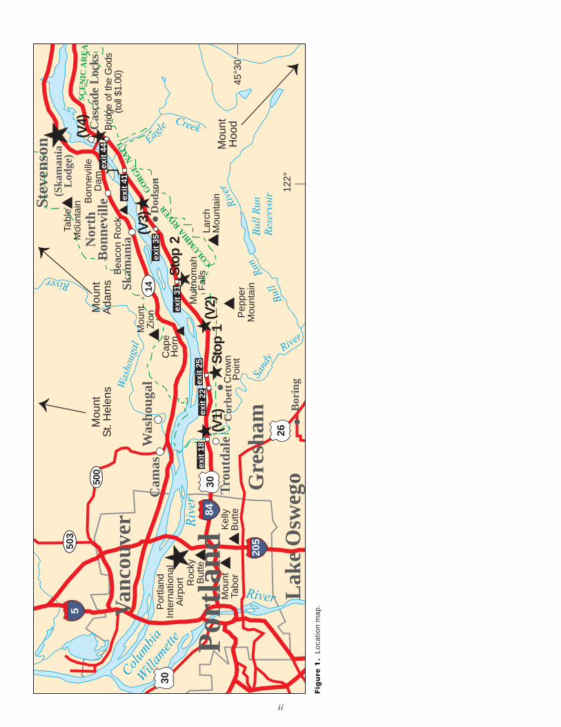
General Directions from the Airport to SkamaniaLodge (N45°41�12.8� W121°54�21.5�) (Distance ap-proximately 42 miles): Leave the airport via I-205South. Exit to Interstate 84 East (toward The Dalles)(Fig. 1). Continue east on I-84 until the Cascade Locks/Bridge of the Gods/Stevenson exit (44). Take theBridge of the Gods over the Columbia River ($1.00toll), then turn right (east) onto Highway 14. Travel ashort distance (1.5 mi from the Bridge of the Gods tomilepost 43 of Highway 14). Turn left onto Rock CreekDrive. Proceed 0.2 mi to the entrance to SkamaniaLodge (on the left).
WASHINGTON STATE GEOLOGY
Washington is uniquely positioned for the study of thegeologic and structural setting of western North Amer-ica. To the south in Oregon and Nevada, extensionalfeatures predominate as reflected by basin-and-rangeterrain. To the east, the Rocky Mountains influence thegeology of Idaho. To the north, western British Colum-bia is characterized by a massive coastal crystallinebelt and remnants of the geologic continent Wrangel-lia. All of these major crustal features of the adjacentregions terminate in or near Washington. The state’suniqueness is further enhanced by three major geologicconditions. First, Washington is impacted by crustaltectonics as the oceanic Juan de Fuca plate is beingsubducted under the North American continent (Fig.2). Second, the Columbia Basin (Fig. 3) in Washingtonand adjacent Oregon was subjected to great outpour-ings of basalt. Third, alpine and continental glaciationand glacial floods have created spectacular landformsin the North Cascades, Puget Sound, and the Chan-neled Scablands.
Washington’s geology is highly diverse. Rocks ofPrecambrian age, as well as units from every geologicperiod, Cambrian to Quaternary, are represented. Thestate has been subject to continental collisions, meta-morphism, intrusion of igneous rocks, volcanism,mountain-building episodes, erosion, glaciation, andmassive flooding events. This diversity has a strong in-fluence on soil productivity, location of mineral depos-its, scenic grandeur, and even the climate. (Modifiedfrom the USGS/Cascades Volcano Observatory web-site at http://vulcan.wr.usgs.gov.)
The Columbia River
The Columbia River pours more water into the PacificOcean than any other river in North or South America.In its 1270-mi (2045-km) course to the Pacific Ocean,
1
2 4 6
JUAN DE
OLYMPICMOUNTAINS
CA
SC
AD
ER
AN
GE
?
75 91 3123
FUCA PLATE
age of sea floor in m.y.
PACIFIC PLATE
MountSt. Helens
Mount Adams
MountRainier
Mount Baker
GlacierPeak
MountGaribaldi
CANADA
U.S.
fracturezone
Juan
de
Fuca
Rid
ge
convergence
zone
Olympia
Seattle
NO
RTH
AM
ER
ICA
N
PLA
TEJUAN
DE FUCAPLATE
spre
adin
gzo
ne
Yakima
mélange
PA
CIF
ICP
LA
TE
fore–arcfaults and
folds
NORTHAMERICAN
PLATEMANTLE
bouyant magma (mainly basalt) risesto form new ocean crust
partial melting of subducting ocean crust forms magma(mainly andesite) that fuels Cascade Range volcanoes
Figure 2. A diagrammatic cross section through the Juan de Fuca spreadingridge and the Cascadia subduction zone (the area from the convergence zoneeast to where the Juan de Fuca plate sinks beneath the North American plate),showing the magnetic orientation of the sea floor recorded at the Juan de Fucaspreading ridge. Darker stripes in the cross section of the sea floor indicate timeswhen rock was created with a magnetic orientation of north. Notice that the age ofthe ocean floor is progressively older with distance from the spreading zone. Thepattern of ages approximately parallels the ridge on both sides. Mélange is a jum-bled mixture of continental shelf blocks and oceanic sediments that is faulted andsheared at shallow depths in the subduction zone. Fore-arc folds and faults occurin a zone of crustal deformation between the subducting sea floor and the volcanicarc. Redrawn from Foxworthy and Hill (1982), Uyeda (1978), and Pringle (2002).
COLUMBIABASIN
BLUEMOUNTAINS
CA
SCA
DE
RA
NG
EOLYMPICMOUNTAINS
WILLAPAHILLS
PORTLANDBASIN
PUGETLOWLAND
OKANOGAN HIGHLANDS
YAKIMAFOLD BELT
PALOUSESLOPE
NORTH EASTWEST
SOUTH
Spokane
Pullman
Lewiston
Seattle
Portland
0
0 50
50
150 km
100 mi
100
Figure 3. The physiographic provinces and subprovinces of Washington State.Subprovinces are separated by a dashed line. The Columbia River Basalt Groupunderlies the Columbia Basin, part of the Portland Basin, and part of the WillapaHills, as well as adjacent areas of Oregon and Idaho.

2 OPEN FILE REPORT 2004-7
Col
umbi
aR
iver
Yaki
ma
Riv
erC
olum
bia
Riv
er
Cow
litz
Riv
er
Colu
mbia
R.
Spoka
ne
R.
ColumbiaRiver
PA C I F I C O C E A N
Gla
cial
Lake
Mis
soula
Cla
rk
Fork
R.
Cle
arw
ater
Riv
er
Snak
e
Riv
er
Columbia
River
Gla
cial
Lake
Spoka
ne
Snake
River
OR
EG
ON
Ever
ett
SE
AT
TL
E
TA
CO
MA
Oly
mp
ia
Yak
ima
Pu
llm
an
Wall
aW
all
a
Ric
hla
nd
Pasc
o
Ken
new
ick
Wen
atc
hee
Mose
sL
ak
e
MO
NTA
NA
Dru
mm
on
d
BITTERROOTRANGE
Mis
sou
la
Darb
y
RO
CK
Y
MO
UN
T AI N
SIC
ED
AM
Per
ma
Lew
isto
n
IDA
HO
SP
OK
AN
E
49
°
PO
RT
LA
ND
Mo
un
tA
da
ms
Mo
un
tS
t.H
ele
ns
Mo
un
tR
ain
ierM
ou
nt
Ba
ke
r
Gla
cie
rP
ea
k
Mo
un
tH
oo
d
CO
RD
ILL
ER
AN
ICE
SH
EE
T
Mo
un
tJe
ffe
rso
n
OL
YM
PIC
MO
UN
TA
INS
C A S C A D ER A N G E
CH
AN
NE
LE
D
SC
AB
LA
ND
S
PA
SC
OB
AS
IN
Wa
llula
Ga
p
Th
eD
all
es
Hood
Riv
er
Sk
am
an
iaL
od
ge
Prie
st
Ra
pid
sD
am
Gra
nd
Co
ule
eD
am
McN
ary
Da
m
Jo
hn
Da
yD
am
Th
eD
alle
sD
am
Bo
nn
evill
eD
am
Hig
hla
nd
Butte
Tro
utd
ale
MISSIONRANGE
EX
PL
AN
AT
ION
La
rch
Mo
un
tain
117
o125°
46
o
CA
NA
DA
USA
US
A
CA
NA
DA
02
04
06
0m
i
Colu
mbia
Riv
erB
asal
tG
roup
Are
asc
oure
dby
Mis
soula
floods
Gla
cial
Lak
es
Ice-
cover
edL
akes
Fig
ure
4.
Th
ep
rob
ab
lee
xte
nt
of
the
Co
rdille
ran
ice
sh
ee
t,ic
e-d
am
me
dg
lacia
lla
ke
s,
Mis
so
ula
flo
od
s,
an
dC
olu
mb
iaR
ive
rB
asa
ltG
rou
p.
Th
efa
ilu
reo
fth
eic
ed
am
of
the
Cla
rkF
ork
Riv
er
inw
este
rnM
on
tan
are
lea
se
da
20
00
ft(6
00
m)
wa
llo
fw
ate
rth
atru
sh
ed
acro
ss
ea
ste
rnW
ash
ing
ton
ag
ain
an
da
ga
in,e
rod
ing
ase
rie
so
fin
tert
win
ing
ca
nyo
ns
ca
lle
dco
ule
es.T
his
are
ais
kn
ow
na
sth
eC
ha
nn
ele
dS
ca
bla
nd
s.T
he
va
rio
us
flo
od
pa
thw
ays
co
nve
rge
din
the
Pa
sco
Ba
sin
,w
he
reth
ere
wa
sa
na
rro
we
xit
for
the
wa
ters
—W
allu
laG
ap
.T
he
na
rro
wn
ess
ofth
eg
ap
ca
use
dth
efl
oo
d-
wa
ters
tob
ack
up
an
dfo
rma
12
00
-ft
(36
5-m
)-d
ee
pla
ke
co
ve
rin
go
ve
r3
50
0m
i2(9
00
0km
2).
Se
ve
ralo
the
rte
mp
ora
ryla
ke
sw
ere
cre
ate
db
ysim
ila
re
ve
nts
ne
ar
Th
eD
alle
sa
nd
Po
rtla
nd
,O
re.
(Mo
dif
ied
fro
mW
ait
t,1
98
5,
an
dW
eis
an
dN
ew
ma
n,
19
89
.E
xte
nt
of
the
Co
lum
bia
Riv
er
Ba
sa
ltG
rou
pfr
om
Re
ide
la
nd
oth
ers
,1
99
4.)

the Columbia flows through four moun-tain ranges—the Rockies, Selkirks, Cas-cades, and coastal mountains—anddrains 258,000 mi2 (670,000 km2). Themain stem of the Columbia rises in Co-lumbia Lake on the west slope of theRocky Mountains in Canada. Its largesttributary, the Snake River, travels 1038mi (1670 km) from its source in Yellow-stone National Park in Wyoming beforejoining the Columbia.
The Columbia River Gorge is a spec-tacular canyon cutting through the Cas-cade Range. The Gorge is 80 mi (130km) long and up to 4000 ft (1200 m)deep, with the north canyon walls inWashington State and the south canyonwalls in Oregon State. The gorge is theonly near sea-level passage through theCascades.
When Lewis and Clark explored theregion in the early 19th century, huge numbers of salmon re-turned to spawn every year. “The multitudes of this fish are al-most inconceivable,” Clark wrote in the autumn of 1805. At thattime, the Columbia and its tributaries provided 12,935 mi(20,800 km) of pristine river habitat. (Modified from a U.S.Army Corps of Engineers information brochure)
Columbia River Basalt Group
The Columbia River Basalt Group (CRBG)(Fig. 4) is the princi-pal rock unit in the gorge. The CRBG is a series of basalt flows(flood or fissure basalts) that were erupted between 17 millionand 6 million years ago during the Miocene. The flows origi-nated from northwest-striking feeder dikes in eastern Washing-ton and Oregon and spread westward across the Columbia Basin(Figs. 3 and 4). Most of the lava flooded out in the first 1.5 mil-lion years—an extraordinarily short time for such an outpouringof molten rock. It is difficult to conceive of the enormity of theseeruptions. Basaltic lava erupts at no less than about 1100°C. Ba-salt is a very fluid lava; it is likely that tongues of lava advancedat an average of 3 mi/hr (5 km/hr). Whatever topography waspresent prior to the CRBG eruptions was buried and smoothedover by flow upon flow of lava. More than 300 high-volume in-dividual lava flows have been identified, along with countlesssmaller flows. Numerous linear vents, some over 100 mi (150km) long, show where lava erupted near the eastern edge of theColumbia Basin, but older vents were probably buried byyounger flows. (From the USGS/Cascades Volcano Observa-tory website.)
The flows now cover approximately 105,000 mi2 (272,000km2) and total about 41,830 mi3 (175,000 km3) of basalt (Tolanand others, 1989). On the basis of geophysical evidence, the ba-salts are known to reach a maximum thickness of 16,000 ft(5000 m) in the Pasco Basin. Twenty-one of these flows pouredthrough the Gorge, forming layers of rock up to 2000 ft (600 m)thick. The CRBG is divided into five formations, but only three,the Grande Ronde, Wanapum, and Saddle Mountains Basalts,are exposed in the tour area.
Geologists distinguish the various flows of the CRBG by ex-amining their physical features, geochemistry, and paleomag-netism (Swanson and others, 1979a,b). Chemical compositionand paleomagnetic data have proven to be the most reliable cri-teria for flow identification and correlation.
Glacial Floods
Quaternary deposits in the gorge are those of the cataclysmicMissoula (or Spokane) floods. The Cordilleran ice sheet fromCanada advanced several times during the Pleistocene and cov-ered parts of Washington, Idaho, and Montana. The ice formeddams on the Clark Fork River on the Idaho–Montana border andcreated glacial Lake Missoula (Pardee, 1910)(Fig. 4). The lakecovered 3000 mi2 (7800 km2) of western Montana and held 600mi3 (2500 km3) of water (Carson and Pogue, 1996).
The ice dams failed repeatedly releasing gigantic glacialfloods that swept across northern Idaho, through the SpokaneValley, southwestward across eastern Washington, and downthe Columbia River Gorge enroute to the Pacific Ocean (Carsonand Pogue, 1996). The Missoula floods are the largest knownfloods on Earth in the last two million years; the flow of waterwas ten times the combined flow of all the rivers of the world. Ineastern Washington, the floods created the Channeled Scab-lands, an area studied by J Harlen Bretz in the 1920s. Bretz wasthe first person to describe these gigantic glacial floods.
The flood crest at Wallula Gap on the Columbia River at theWashington–Oregon border was about 1200 ft (365 m) as evi-denced by glacial erratics that were left stranded on the hillside.The water poured down the Columbia Gorge and widened thevalley by cleaning off all the soil and talus up to 1000 ft (300 m)elevation as far as The Dalles, Oregon. By the time it reachedCrown Point, the surface of the last flood had dropped to about600 ft (180 m) elevation (Allen, 1979).
There may have been more than 40 major glacial floods(Waitt, 1980) recorded by bedded slack water deposits (rhythm-ites). The average interval between Missoula floods was about30 years (Waitt and others, 1994). The last flood occurred13,000 years ago.
SELF-GUIDING TOUR
The Portland Area
Metropolitan Portland sits on part of a Plio-Pleistocene volcanicfield. The Boring Lava includes at least 32 and possibly 50 cin-der cones and small shield volcanoes lying within a radius of13 mi (21 km) of Kelly Butte. The volcanoes were probably ac-tive from at least 2.7 million to less than 500,000 years ago.
Northwest of the town of Boring, 20 eruptive centers areconcentrated within about a 39 mi2 (100 km2) area. Vents in the
GEOLOGY OF THE COLUMBIA RIVER GORGE, OREGON AND WASHINGTON 3
Figure 5. Mount Hood as seen from Highway 14 near Camas, Wash. View to the southeast.

east part of this cluster average less than1.6 mi (2.6 km) in diameter and 1090 ft(333 m) in height above their bases.Lavas from Highland Butte and LarchMountain shield volcanoes (Fig. 4) formgently sloping plains covering manytens of square miles. Well logs indicatethat in most places, except near vents,Boring lava is between 100 and 200 ft(30–60 m) thick.
Partial summit craters remain only atBobs Hill, 20.5 mi (33 km) northeast ofPortland, and at a low cone enclosing alake (Battleground Lake) north of Bat-tleground, Wash., 20.5 mi (33 km) northof Portland. Most other volcanoes stillhave a low cone shape and are mantledwith loess above 400 ft (122 m) eleva-tion. Below this they were scoured bythe Missoula floods about 13,000 to15,000 years ago.
Boring Lava is characteristically alight-gray olivine basalt. A specimenfrom Rocky Butte is predominantly lab-radorite, with phenocrysts of olivine,mostly altered to iddingsite. The volca-noes locally contain scoria, cinders,tuff, tuff breccia, and ash. Weatheringmay extend to depths of 25 ft (8 m) ormore, the upper 5 to 15 ft (2–5 m) com-monly being a red clayey soil.
The best and most accessible expo-sure is the cross section of the cindercone in Mount Tabor Park. Numerousquartzite-pebble xenoliths from the un-derlying Mio-Pliocene Troutdale grav-els that make up the bulk of Mount Ta-bor have been found in the cinders here.The best view of the volcanic field isfrom the summit in Rocky Butte Parkwhere massive cliffs of flood-scouredlava form the northeast face of the butte.(Modified from the USGS/Cascades Vol-cano Observatory website.)
As you leave the Portland area, youmay be able to catch a glimpse of MountHood (Fig. 5) to the east and Mount St.Helens to the north if it is a clear day.
VIEWPOINT 1 from I-84: Crossingthe Sandy River(Not a stop)
At Exit 18 (Lewis and Clark State Parkand Sandy River) Mount Hood is thenearest active Cascades volcano to the Columbia River Gorge,sitting about 30 mi (50 km) south of the Gorge between Trout-dale and Hood River (Fig. 4). The Sandy River originates onMount Hood and drains into the Columbia River.
The Sandy River and several of its tributaries have beeninundated by numerous lahars over the past 1800 years. Theselahars have resulted both from collapse of Mount Hood’s south-west flank and from dome-collapse pyroclastic flows fromCrater Rock lava dome. Later remobilization of the pyroclastic
deposits occurred during periods of high precipitation. Laharsattained depths of 30 to 40 ft (9–12 m) above the modern valleyfloor in the Sandy River valley and the deposits reached the Co-lumbia River, a distance of over 55 mi (90 km) (Cameron andPringle, 1987; Scott and others, 1997).
In 1805, Lewis and Clark named the Sandy River “Quick-sand River” in recognition of the 4-mi (6.5-km)-wide saturatedbar of remobilized lahar at the mouth of the river (Cameron andPringle, 1986). The lahar forced the Columbia River channel to
4 OPEN FILE REPORT 2004-7
Figure 6. Looking east from I-84 toward Rooster Rock (just to the left of center) and Crown Point(upper right) with its vista house.
Figure 7. Cape Horn as seen from exit 28 on I-84 on the Oregon side of the Columbia. The capeis the part of these steep cliffs that juts out into the river.

the north at the mouth of the Sandy River, a situation that mostlikely will be repeated during future volcanic-eruption-inducedsedimentation (Wang and others, 2002).
Side Trip: Optional Waterfall Loop
If you are planning to take the Waterfall Loop on the HistoricColumbia River Highway (U.S. 30), leave I-84 at exit 22(Corbett). You will be able to see Crown Point and RoosterRock from the top of the Gorge (cover photo). The loop returnsto I-84 at exit 35 (Dodson).
STOP 1: View of Crown Point and Rooster Rock
Take exit 25 to Rooster Rock State Park, cross I-84, turn left,and follow the road to the end of the west parking lot, near therestrooms, and proceed on to the boat landing. There is a $3.00fee to actually enter the park.
Crown Point (Fig. 6) is a remnant of a thick intracanyon flow ofthe Priest Rapids Member of the Wanapum Basalt of the CRBG(Tolan and others, 1984) that filled an early ancestral canyon ofColumbia River to a total thickness of nearly 700 ft (200 m). Inthe face of the bluff, the lower 130 ft (40 m) of the fill is palago-nite tuff, carried westward and foreset bedded by the ancestralColumbia River. Lava then advanced onto the hyaloclastic fill,piling up quickly in a series of flows to a thickness of 555 ft (170m). The entire thickness of lava congealed as one cooling unitwith an 80-ft (25-m) basal colonnade and a very thick (475 ft)hackly entablature (Waters, 1973).
Rooster Rock (Fig. 6) is a landslide of a portion of the CrownPoint intracanyon fill. You can see the scar where the slide camefrom on the cliff above. Note the rotated-bedded palagonitecapped by fan-jointed columns and hackly entablature in theslide. Several jumbled blocks are present. Rooster Rock itself isa spire from the entablature (Waters, 1973).
Return to I-84 and continue east. High bluffs of ColumbiaRiver basalt on the right are unconformably overlain by Trout-dale gravels, which are capped in turn by olivine basalt flowsfrom Larch and Pepper Mountains (Fig. 1).
VIEWPOINT 2 from I-84: Cape Horn(Not a stop)
Across the river on the Washington side at Cape Horn (Fig. 7)flows of the Grande Ronde Basalt of the CRBG form steep cliffsthat make an excellent stratigraphic marker. Troutdale gravelscap the basalt unconformably and are overlain in turn by lavasof the small Mount Zion olivine basalt shield (Waters, 1973).
STOP 2: Multnomah Falls(If you are going to make one stop, this is it.)
Take exit 31 to your LEFT to Multnomah Falls (Fig. 8). Parkand head toward the old 1925 lodge and visitor center. Mult-nomah Falls is the second-highest year-round waterfall in thenation. It consists of an upper and lower falls over basalt cliffs.The 620-ft (189-m) waterfall is fed by natural springs and melt-ing snows from Larch Mountain to the south. You can hike up awinding path and view the falls from a bridge. You can also hiketo the top of the falls and see where it all begins.
On September 4, 1995, at approximately 5:30 p.m., rocksfrom the face of upper Multnomah Falls broke loose andsmashed down in the upper plunge pool. The upper falls are 541ft (165 m) high. According to the USDA Forest Service, the dis-
lodged rock had approximate dimensions of 40 by 20 by 6 ft (12by 6 by 2 m) and fell a distance of 225 ft (69 m). The jointedbasalt block did not remain intact but, for the most part, shat-tered. Twenty people who were standing on the 70-ft (21-m)-high bridge received minor injuries from being hit by flyingpebble-size debris. The upper plunge pool is now permanentlyclosed for public-safety reasons. In addition, landslide aware-ness signs have been erected in response to this event (Wang andothers, 2002).
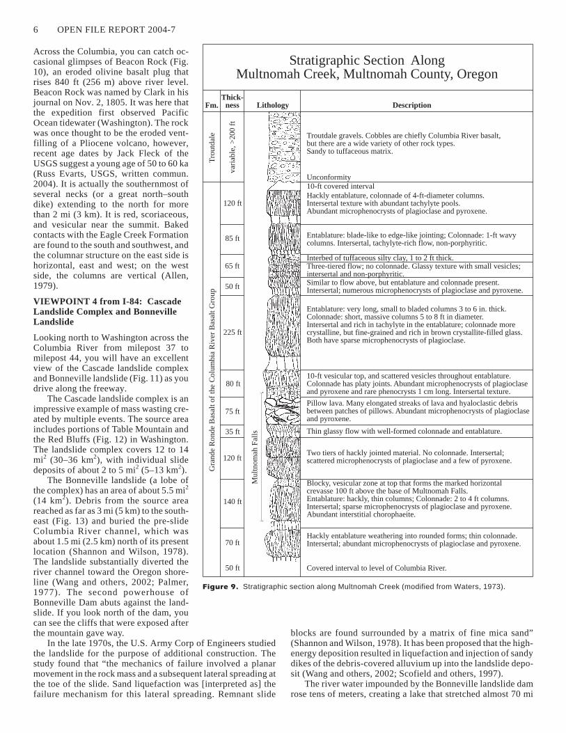
Eleven flows of the Grande Ronde Basalt of the CRBG areexposed along Multnomah Creek (Fig. 9). Six of these flowscrop out from the Columbia River to the top of the upper falls;the rest are exposed upstream of the two falls you see here. Notethe pillow sequence near the lip of the upper falls.
Observations of waterfalls over Columbia River basalt (M.H. Beeson, unpub. data, 1978) have shown that falls often occurwhere flows are flat lying or dipping upstream. This conditionallows blocks produced by vertical joints to remain stable untilsupport is withdrawn by erosion of softer interflow material atthe base of individual flows. The rate of erosion of interflowareas probably largely controls the rate of retreat of the falls.Two falls were produced here because of a more easily erodedzone at the base of the upper falls. The amphitheater-shaped val-leys common to many of the falls within the Gorge are due to thefreeze–thaw action of water from the splash mist that has pene-trated the joints (Tolan and others, 1984).
VIEWPOINT 3 from I-84:Beacon Rock
GEOLOGY OF THE COLUMBIA RIVER GORGE, OREGON AND WASHINGTON 5
Figure 8. Multnomah Falls.
Across the Columbia, you can catch oc-casional glimpses of Beacon Rock (Fig.10), an eroded olivine basalt plug thatrises 840 ft (256 m) above river level.Beacon Rock was named by Clark in hisjournal on Nov. 2, 1805. It was here thatthe expedition first observed PacificOcean tidewater (Washington). The rockwas once thought to be the eroded vent-filling of a Pliocene volcano, however,recent age dates by Jack Fleck of theUSGS suggest a young age of 50 to 60 ka(Russ Evarts, USGS, written commun.2004). It is actually the southernmost ofseveral necks (or a great north–southdike) extending to the north for morethan 2 mi (3 km). It is red, scoriaceous,and vesicular near the summit. Bakedcontacts with the Eagle Creek Formationare found to the south and southwest, andthe columnar structure on the east side ishorizontal, east and west; on the westside, the columns are vertical (Allen,1979).
VIEWPOINT 4 from I-84: CascadeLandslide Complex and BonnevilleLandslide
Looking north to Washington across theColumbia River from milepost 37 tomilepost 44, you will have an excellentview of the Cascade landslide complexand Bonneville landslide (Fig. 11) as youdrive along the freeway.
The Cascade landslide complex is animpressive example of mass wasting cre-ated by multiple events. The source areaincludes portions of Table Mountain andthe Red Bluffs (Fig. 12) in Washington.The landslide complex covers 12 to 14mi2 (30–36 km2), with individual slidedeposits of about 2 to 5 mi2 (5–13 km2).
The Bonneville landslide (a lobe ofthe complex) has an area of about 5.5 mi2
(14 km2). Debris from the source areareached as far as 3 mi (5 km) to the south-east (Fig. 13) and buried the pre-slideColumbia River channel, which wasabout 1.5 mi (2.5 km) north of its presentlocation (Shannon and Wilson, 1978).The landslide substantially diverted theriver channel toward the Oregon shore-line (Wang and others, 2002; Palmer,1977). The second powerhouse ofBonneville Dam abuts against the land-slide. If you look north of the dam, youcan see the cliffs that were exposed afterthe mountain gave way.
In the late 1970s, the U.S. Army Corp of Engineers studiedthe landslide for the purpose of additional construction. Thestudy found that “the mechanics of failure involved a planarmovement in the rock mass and a subsequent lateral spreading atthe toe of the slide. Sand liquefaction was [interpreted as] thefailure mechanism for this lateral spreading. Remnant slide
blocks are found surrounded by a matrix of fine mica sand”(Shannon and Wilson, 1978). It has been proposed that the high-energy deposition resulted in liquefaction and injection of sandydikes of the debris-covered alluvium up into the landslide depo-sit (Wang and others, 2002; Scofield and others, 1997).
The river water impounded by the Bonneville landslide damrose tens of meters, creating a lake that stretched almost 70 mi
6 OPEN FILE REPORT 2004-7
Tro
utd
ale
Fm.
Gra
nde
Ronde
Bas
altof
the
Colu
mbia
Riv
erB
asal
tG
roup
Thick-ness Lithology Description
Stratigraphic Section AlongMultnomah Creek, Multnomah County, Oregon
var
iable
,>
200
ft
120 ft
85 ft
65 ft
50 ft
225 ft
80 ft
75 ft
35 ft
120 ft
Mult
nom
ahF
alls
140 ft
70 ft
50 ft Covered interval to level of Columbia River.
Troutdale gravels. Cobbles are chiefly Columbia River basalt,but there are a wide variety of other rock types.Sandy to tuffaceous matrix.
Unconformity10-ft covered interval
Hackly entablature, colonnade of 4-ft-diameter columns.Intersertal texture with abundant tachylyte pools.Abundant microphenocrysts of plagioclase and pyroxene.
Entablature: blade-like to edge-like jointing; Colonnade: 1-ft wavycolumns. Intersertal, tachylyte-rich flow, non-porphyritic.
Interbed of tuffaceous silty clay, 1 to 2 ft thick.Three-tiered flow; no colonnade. Glassy texture with small vesicles;intersertal and non-porphyritic.Similar to flow above, but entablature and colonnade present.Intersertal; numerous microphenocrysts of plagioclase and pyroxene.
Entablature: very long, small to bladed columns 3 to 6 in. thick.Colonnade: short, massive columns 5 to 8 ft in diameter.Intersertal and rich in tachylyte in the entablature; colonnade morecrystalline, but fine-grained and rich in brown crystallite-filled glass.Both have sparse microphenocrysts of plagioclase.
10-ft vesicular top, and scattered vesicles throughout entablature.Colonnade has platy joints. Abundant microphenocrysts of plagioclaseand pyroxene and rare phenocrysts 1 cm long. Intersertal texture.
Pillow lava. Many elongated streaks of lava and hyaloclastic debrisbetween patches of pillows. Abundant microphenocrysts of plagioclaseand pyroxene.
Thin glassy flow with well-formed colonnade and entablature.
Two tiers of hackly jointed material. No colonnade. Intersertal;scattered microphenocrysts of plagioclase and a few of pyroxene.
Blocky, vesicular zone at top that forms the marked horizontalcrevasse 100 ft above the base of Multnomah Falls.Entablature: hackly, thin columns; Colonnade: 2 to 4 ft columns.Intersertal; sparse microphenocrysts of plagioclase and pyroxene.Abundant interstitial chorophaeite.
Hackly entablature weathering into rounded forms; thin colonnade.Intersertal; abundant microphenocrysts of plagioclase and pyroxene.
Figure 9. Stratigraphic section along Multnomah Creek (modified from Waters, 1973).

(113 km)(up to the present-day John Day Dam).After a few months, the Columbia rose highenough to wash through the southern side of thelandslide creating a flood of water that was 100 ft(30 m) deep at Troutdale (Scofield and others,1997). Afterwards, things returned to normal, ex-cept that the river was displaced a mile to thesouth and the Cascade Rapids had formed.
Evidence for the landslide dam includes sub-merged tree stumps observed upstream (Law-rence, 1937; Lawrence and Lawrence, 1958).Evidence for catastrophic flooding from thebreach has been observed downstream near themouth of the Sandy River and at other locations(O’Connor and others, 1996; Lunney and Taylor,2000). The Cascade Rapids, which developedfrom the breaching of the landslide dam, andthe submerged forests were later inundated bythe reservoir from the 1938 Bonneville Dam(Schuster and Pringle, 2002).
Although the slide complex has been exten-sively studied, the exact age of the slide remainsa controversy. An 1830s account of an early Na-tive American legend describes the Cascade Rap-ids as follows: “The Indians say those falls arenot ancient, and that their fathers voyaged with-out obstruction in their canoes as far as TheDalles. They also assert that the river wasdammed up at this place, which caused the watersto rise to a great height far above and that aftercutting a passage through the impeding massdown to its present bed, those rapids first madetheir appearance” (Lawrence, 1937). Anotherversion tells of the sons of Old Coyote, Wy’east(Mount Hood) and Pahto (Mount Adams), aspowerful braves both in love with a maiden(Mount St. Helens). Because they crossed the“Bridge of the Gods” to fight over their love forher, Old Coyote collapsed the land bridge to keephis sons from fighting.
This “Bridge of the Gods” landslide dam wasformed by the Bonneville landslide, which is the youngest andlargest of four portions of the Cascade landslide complex. Re-cent radiocarbon studies indicate a calendar age of some timeduring the 15th century for this landslide (Pat Pringle, Wash.Divn. of Geology and Earth Resources, oral commun., 2004).
Take exit 44 toward CASCADE LOCKS/STEVENSON.
Turn onto BRIDGE OF THE GODS and cross the ColumbiaRiver into Washington State.
This a toll bridge and you will need $1.00 both ways.
GEOLOGY OF THE COLUMBIA RIVER GORGE, OREGON AND WASHINGTON 7
Figure 10. Beacon Rock (front) and Hamilton
Mountain (background) on the Washington State side
of the Columbia River.
Figure 11. Aerial-oblique photo of the Bonneville
landslide. View is to the northeast with Mount Adams
volcano in the distance. The Bonneville Dam and pow-
erhouses (lower left) and the “Bridge of the Gods”
highway (far right) flank the landslide. (Photo courtesy
of Derek Cornforth.)
Figure 12. Bonneville landslide (wooded area) as
seen from Cascade Locks. Table Mountain (3417 ft/
1042 m) is on the left and Greenleaf Peak (3422 ft/
1043 m) is on the right. Red Bluffs is the scarp area
just below Greenleaf Peak. The Bridge of the Gods is
just out of camera view to the left, and Skamania
Lodge is just out of camera view to the right.

This steel bridge was named for the“Bridge of the Gods” landslide dam.
At the junction with State Route 14,turn right (east) and travel 1.5 mi.
You are now skirting the toe of the Cas-cade landslide complex. Note the hum-mocky ground and the jumble of rocksfrom different formations in the slide.As you pass Ashes Lake (Fig. 13), youhave a good view of the cliffs formingthe scarp at the head of the landslide.
Immediately after entering Stevensoncity limits, turn left onto Rock CreekDrive and go 0.2 mi to the entrance toSkamania Lodge.
You have arrived at Skamania Lodge,Washington. Skamania Lodge wasconstructed on the eastern edge of thelarge Cascade landslide complex, whichis generally considered to be stableground. The lodge provides an excellentview of the river, the gorge, and thelandslides.
REFERENCES
Allen, J. E., 1979, The magnificent gate-way—A layman’s guide to the geologyof the Columbia River gorge: TimberPress [Forest Grove, Ore.] Scenic Tripsto the Northwest’s Geologic Past 1,144 p.
Cameron, K. A.; Pringle, P. T., 1986, Post-glacial lahars of the Sandy River basin,Mount Hood, Oregon: Northwest Sci-ence, v. 60, no.4, p. 225-237.
Cameron, K. A.; Pringle, P. T., 1987, A de-tailed chronology of the most recentmajor eruptive period at Mount Hood,Oregon: Geological Society of AmericaBulletin, v. 99, no. 6, p. 845-851.
Carson, R. J.; Pogue, K. R., 1996, Flood ba-salts and glacier floods—Roadside ge-ology of parts of Walla Walla, Franklin,and Columbia Counties, Washington:Washington Division of Geology andEarth Resources Information Circular90, 47 p.
Foxworthy, B. L.; Hill, Mary, 1982, Vol-canic eruptions of 1980 at Mount St. Helens—The first 100 days:U.S. Geological Survey Professional Paper 1249, 125 p.
Hill, R. L., 1999, repr. 2001, A new look at an old landslide—Radio-carbon dates indicate the Bonneville landslide may be far youngerthan thought: Washington Geology, v. 29, no. 1/2, p. 35-38.[http://www.wa.gov/dnr/htdocs/ger/pdf/1news01.pdf]
Lawrence, D. B., 1937, Drowned forests of the Columbia River gorge:Geological Society of the Oregon Country Geological News Let-ter, v. 3, no. 8, p. 78-83.
Lawrence, D. B.; Lawrence, E. G., 1958, Bridge of the Gods legend—Its origin, history, and dating: Mazama, v. 40, no. 13, p. 33-41.
Lunney, Meghan; Taylor, J. M., 2000, Analysis of probable Bridge ofthe Gods landslide dam outburst sediments in the lower ColumbiaRiver basin [abstract]: Geological Society of America Abstractswith Programs, v. 32, no. 6, p. A-26.
O’Connor, J. E.; Pierson, T. C.; Turner, Daniel; Atwater, B. F.;
Pringle, P. T., 1996, An exceptionally large Columbia River flood
between 500 and 600 years ago—Breaching of the Bridge-of-the-
Gods landslide? [abstract]: Geological Society of America Ab-
stracts with Programs, v. 28, no. 5, p. 97.
Palmer, L. A., 1977, Large landslides of the Columbia River gorge,
Oregon and Washington. In Coates, D. R., editor, Landslides:
Geological Society of America Reviews in Engineering Geology,
v. III, p. 69-83.
8 OPEN FILE REPORT 2004-7
1000
250
500
250
1000
250750
500
250
250
500
500
750
750
500
750
1000
CascadeLocks
BonnevilleDam
TableMtn
Red
Bluffs
Stevenson
WaunaLake
SKAM
ANIA
CO
MU
LT
NO
MA
HC
O
HO
OD
RIV
ER
CO
Columbia R.
Red Bluffs landslide
Ca
rpe
nte
rsL
ak
e
lan
dslid
e second powerhouse(built in 1978)
Moseley
Lakes
landslide
Bridge ofthe Gods
Bonneville
landslid
e
14
WASH
ING
TON
OREG
ON
C
P L E
A S C AD
E
S
DN
LA
SL
I DE
CO M
X
contour interval 50 m
AshesLake
8484
A
B
Table Mountain
Columbia River Basalt Group
volcanic breccia, conglomerate,and sandstone
landslide debris WaunaLake
ColumbiaRiver
old channel ofColumbia R.
tuffaceous sandstone, siltstone,claystone, and conglomerate
A
B
??
SkamaniaLodge
GreenleafPeak
0 2 mi
0 3 km
1
1 2
122º
45º40¢
0
1 2 km
1 mi
0
Figure 13. Approximate boundary of the Bonneville landslide within the Cascades landslidecomplex, dashed where approximate maximum extent inferred (after Schuster and Pringle, 2002);simplified cross section (A–B) through the Bonneville landslide from Table Mountain to the south-ern shore of the Columbia River (after U.S. Army Engineer District, 1976).
Pardee, J. T., 1910, The glacial Lake Missoula: Journal of Geology,v. 18, p. 376-386.
Pringle, P. T., 2002, Roadside geology of Mount St. Helens NationalVolcanic Monument and vicinity; rev. ed.: Washington Divisionof Geology and Earth Resources Information Circular 88, rev. ed.,122 p.
Reidel, S. P.; Tolan, T. L.; Beeson, M. H., 1994, Factors that influ-enced the eruptive and emplacement histories of flood basaltflows—A field guide to selected vents and flows of the ColumbiaRiver Basalt Group. In Swanson, D. A.; Haugerud, R. A., editors,Geologic field trips in the Pacific Northwest: University of Wash-ington Department of Geological Sciences, v. 1, p. 1B 1 - 1B 18.
Sager, J. W., 1989, Bonneville Dam. In Galster, R. W., chairman, En-gineering geology in Washington: Washington Division of Geol-ogy and Earth Resources Bulletin 78, v. I, p. 337-346.
Schuster, R. L.; Pringle, P. T., 2002, Engineering history and impactsof the Bonneville landslide, Columbia River gorge, Washington-Oregon, USA. In Rybar, Jan; Stemberk, Joseph; Wagner, Peter,editors, Landslides—Proceedings of the First European Confer-ence on Landslides: A. A. Balkema, p. 689-699.
Scofield, D. H.; Harvey, A. F.; Burns, S. F., 1997, Engineering geol-
ogy of the Columbia River gorge—Association of Engineering
Geologists 40th Annual Meeting field trip: Association of Engi-
neering Geologists, 27 p.
Scott, W. E.; Pierson, T. C.; Schilling, S. P.; Costa, J. E.; Gardner, C.A.; Vallance, J. W.; Major, J. J., 1997, Volcano hazards in theMount Hood region, Oregon: U.S. Geological Survey Open-FileReport 97-89, 14 p., 1 plate. [http://vulcan.wr.usgs.gov/Volcanoes/Hood/Hazards/OFR97-89/framework.html]
Suchanek, Ron, 1974, The Columbia River gorge—The story of theriver and the rocks: Ore Bin, v. 36, no. 12, p. 197-214.
Swanson, D. A.; Anderson, J. L.; Bentley, R. D.; Camp, V. E.;Gardner, J. N.; Wright, T. L., 1979a, Reconnaissance geologicmap of the Columbia River Basalt Group in eastern Washingtonand northern Idaho: U.S. Geological Survey Open-File Report79-1363, 12 sheets, 26 p. text.
Swanson, D. A.; Wright, T. L.; Hooper, P. R.; Bentley, R. D., 1979b,Revisions in stratigraphic nomenclature of the Columbia RiverBasalt Group: U.S. Geological Survey Bulletin 1457-G, 59 p., 1plate.
Tolan, T. L.; Beeson, M. H.; Vogt, B. F., 1984, Exploring the Neo-gene history of the Columbia River—Discussion and geologicfield trip guide to the Columbia River gorge; Part II, Road log andcomments: Oregon Geology, v. 46, no. 9, p. 103-112.
Tolan, T. L.; Reidel, S. P., compilers, 1989, Structure map of a por-tion of the Columbia River flood-basalt province. In Reidel, S. P.;Hooper, P. R., editors, Volcanism and tectonism in the ColumbiaRiver flood-basalt province: Geological Society of America Spe-cial Paper 239, plate, scale 1:500,000.
Tolan, T. L.; Reidel, S. P.; Beeson, M. H.; Anderson, J. L.; Fecht, K.R.; Swanson, D. A., 1989, Revisions to the estimates of the arealextent and volume of the Columbia River Basalt Group. In Reidel,S. P.; Hooper, P. R., editors, Volcanism and tectonism in the Co-lumbia River flood-basalt province: Geological Society of Amer-ica Special Paper 239, p. 1-20.
U.S. Army Corps of Engineers, 1976, Bonneville dam—Second pow-erhouse; Design memorandum no. 7, Supplement no. 5, HamiltonCreek bridge and west highway underpass tunnel: U.S. ArmyCorps of Engineers, 4 p., 5 plates.
U.S. Army Corps of Engineers, 1976, Columbia River basin, Oregon-Washington, Bonneville lock and dam; 2nd powerhouse railroadtunnel, design memorandum no. 7, supplement no. 4: U.S. ArmyCorps of Engineers, 1 v.
Uyeda, Seiya, 1978, The new view of the Earth— Moving continentsand moving oceans: W. H. Freeman and Company, 217 p.
Waitt, R. B., Jr., 1980, About forty last-glacial Lake Missoulajokulhlaups through southern Washington: Journal of Geology,v. 88, no. 6, p. 653-679.
Waitt, R. B., Jr., 1985, Case for periodic, colossal jokulhlaups fromPleistocene glacial Lake Missoula: Geological Society of Amer-ica Bulletin, v. 96, no. 10, p. 1271-1286.
Waitt, R. B.; O’Connor, J. E.; Benito, Gerardo, 1994, Scores of gigan-tic, successively smaller Lake Missoula floods through Chan-neled Scabland and Columbia valley. In Swanson, D. A.;Haugerud, R. A., editors, Geologic field trips in the Pacific North-west: University of Washington Department of Geological Sci-ences, v. 1, p. 1K 1 - 1K 88.
Wang, Yumei; Hofmeister, R. J.; McConnell, Vicki; Burns, S. F.;Pringle, P. T., 2002, Columbia River gorge landslides—Field tripguidebook for the National Academies: [Privately published bythe authors], 22 p.
Waters, A. C., 1973, The Columbia River gorge—Basalt stratigraphy,ancient lava dams, and landslide dams. In Beaulieu, J. D., Geolog-ic field trips in northern Oregon and southern Washington: Ore-gon Department of Geology and Mineral Industries Bulletin 77,p. 133-162.
Weis, P. L.; Newman, W. L., 1989, The channeled scablands of east-ern Washington—The geologic story of the Spokane flood; 2nded.: Eastern Washington University Press, 24 p. �
GEOLOGY OF THE COLUMBIA RIVER GORGE, OREGON AND WASHINGTON 9